Planning Board Draft January 2022
←
→
Page content transcription
If your browser does not render page correctly, please read the page content below
Planning Board Draft
                     January 2022

                                    1
     Montgomeryplanning.org
ABSTRACT
Corridor Forward: The I-270 Transit Plan contains an examination of and recommendations for a transit
network, which includes both a near-term network of dedicated bus lanes and a long-term
recommendation for an extension of Metrorail’s Red Line. The near-term network of dedicated bus lanes
builds on existing master planned projects, including the MD 355 and Veirs Mill Road Bus Rapid Transit (BRT)
projects to create a transit network that serves communities and employment centers along the I-270
corridor. Corridor Forward re-envisions the master planned Corridor Cities Transitway as a network of
dedicated bus lanes, which connect the I-270 corridor communities to the county’s existing and planned
rapid transit network.

Corridor Forward is a functional master plan that looks ahead 25 years from the date of adoption. The Plan’s
first priority is the immediate implementation of the MD 355 BRT and Veirs Mill Road BRT. The Plan’s second
priority is the Corridor Connectors, and the third priority is the Red Line Extension. Incremental
implementation of the Corridor Connectors and pursuit of actions to advance the Red Line Extension are
envisioned over the Plan’s horizon.

This Functional Master Plan is an amendment to the 2013 Countywide Transit Corridors Functional Master
Plan and the 2018 Master Plan of Highways and Transitways. It also amends The General Plan (On Wedges
and Corridors) for the Physical Development of the Maryland-Washington Regional District in Montgomery and
Prince George’s Counties, as amended; the 1989 Germantown Master Plan; 1994 Clarksburg Master Plan and
Hyattstown Special Study Area, as amended; 2009 Germantown Employment Area Sector Plan; 2010 Great
Seneca Science Corridor Master Plan, as amended; 2014 10 Mile Creek Area Limited Amendment Clarksburg
Master Plan and Hyattstown Special Study Area; 2016 Montgomery Village Master Plan; 2019 MARC Rail
Communities Sector Plan; and 2021 Shady Grove Sector Plan Minor Master Plan Amendment.

Source of Copies
The Maryland-National Capital Park and Planning Commission
2425 Reedie Drive, 14th Floor, Wheaton MD 20902
Online at montgomeryplanning.org/corridorforward

The Maryland-National Capital Park and Planning Commission
The Maryland-National Capital Park and Planning Commission (M-NCPPC) is a bi-county agency created by the General
Assembly of Maryland in 1927. The Commission’s geographic authority extends to the great majority of Montgomery and
Prince George’s Counties; the Maryland-Washington Regional District (M-NCPPC planning jurisdiction) comprises 1,001
square miles, while the Metropolitan District (parks) comprises 919 square miles, in the two counties.

The Commission is charged with preparing, adopting, and amending or extending The General Plan (On Wedges and
Corridors) for the Physical Development of the Maryland-Washington Regional District in Montgomery and Prince George’s
Counties. The Commission operates in each county through Planning Boards appointed by those county governments. The
Planning Boards are responsible for all local plans, zoning amendments, subdivision regulations and administration of
parks.

The M-NCPPC encourages the involvement and participation of individuals with disabilities and its facilities are accessible.
For assistance with special needs (e.g., large print materials, listening devices, sign language interpretation, etc.), please
contact the M-NCPPC Montgomery County Commissioners Office by telephone 301-495-4605 or by email at
mcpchair@mncppc-mc.org. Maryland residents can also use the free Maryland Relay Service for assistance with calls to or
from hearing or speech impaired persons; for information, go to www.mdrelay.org/ or call 866-269-9006.
                                                                                                                                 2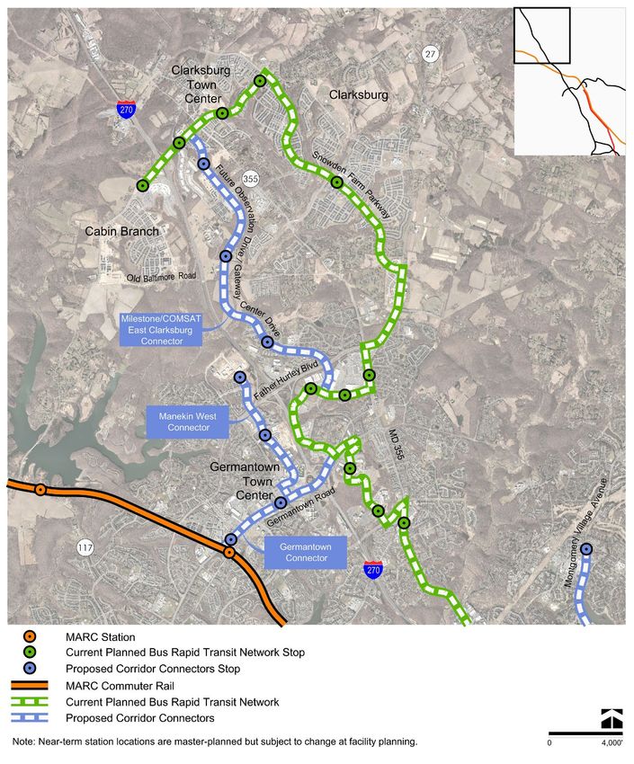
TABLE OF
CONTENTS
Front Matter ................................................................................................................... 5
  About the Plan .................................................................................................................................... 5
  Corridor Forward in Context .............................................................................................................. 5
  How to Read this Text......................................................................................................................... 6
Chapter 1 – Executive Summary ....................................................................................... 7
  The Proposed Network....................................................................................................................... 7
  Additional Recommendations ......................................................................................................... 10
Chapter 2 - Premise ....................................................................................................... 14
  Yesterday’s Transit Vision Stuck in Today’s Gridlock ..................................................................... 14
  The Purpose and Process of Corridor Forward ............................................................................... 15
  All Aboard…But To and From Where? ............................................................................................. 15
  Transit Values and Metrics ............................................................................................................... 16
Chapter 3 – Options Inventory........................................................................................ 18
  When Everything is a Priority… ....................................................................................................... 18
  Initial Menu – Transit Options Inventory ......................................................................................... 19
  Other Modes...................................................................................................................................... 21
  Curated Menu of Transit Options for Study..................................................................................... 21
Chapter 4 – Initial Evaluation ......................................................................................... 23
  The Approach.................................................................................................................................... 23
  Purple Line Extension ....................................................................................................................... 24
  Enhanced MARC Rail......................................................................................................................... 25
  Frederick Rail Connection ................................................................................................................ 27
  Corridor Cities Transitway (CCT)...................................................................................................... 28
  Managed Lanes Enhanced Commuter Bus...................................................................................... 30
  Red Line Extension ........................................................................................................................... 31
  Performance Outcomes ................................................................................................................... 32
Chapter 5 – Proposed Transit Network ............................................................................ 33
  Transit Network – Near-Term Dedicated Bus Lanes ....................................................................... 34
  The Regional Benefits of Proposed Connectors.............................................................................. 43
  Roadway and Transitway Recommendations ................................................................................ 44
  Proposed Transit Network –Long-Term Recommendation ........................................................... 48
Chapter 6 – Implementation Strategies........................................................................... 53
  Prioritization of Proposed Transit Network – Near-Term Dedicated Bus Lanes .......................... 54
  Advancing the Near-Term Dedicated Bus Lanes ............................................................................. 56
  Advancing the Long-Term Vision of the Recommended Network ................................................. 57
Chapter 7 – Conclusion .................................................................................................. 59

                                                                                                                                                          3
LIST OF TABLES
Table 1 – Recommendation Structure ................................................................................................................................ 10
Table 2 – Summary of Recommendations .......................................................................................................................... 11
Table 3 – Corridor Forward Goal and Values ....................................................................................................................... 16
Table 4 – Initial Menu of Transit Options ............................................................................................................................. 20
Table 5 – Initial Evaluation (2045)........................................................................................................................................ 24
Table 6 – Purple Line Extension Recommendations .......................................................................................................... 25
Table 7 – Enhanced MARC Rail Recommendations ............................................................................................................ 27
Table 8 – Frederick Rail Connection Recommendation ..................................................................................................... 28
Table 9 – Master Planned CCT Purposes and Barriers ........................................................................................................ 29
Table 10 – Managed Lanes Enhanced Commuter Bus Recommendation ......................................................................... 31
Table 11 – The Proposed Transit Network Recommendation............................................................................................ 33
Table 12 – North Bethesda Transitway Recommendation ................................................................................................. 34
Table 13 – Great Seneca Transit Network Recommendation............................................................................................. 44
Table 14 – Roadway and Transitway Recommendations ................................................................................................... 45
Table 15 – Advisory Only - Roadway and Transitway Recommendations within Municipal Bounds ............................... 47
Table 16 – Recommendations to Support Transit Access and Connectivity ..................................................................... 52
Table 17 – Recommendations for Efficient and Effective Implementation ....................................................................... 53
Table 18 – Recommendations to Enhance Transit’s Competitiveness .............................................................................. 54
LIST OF FIGURES
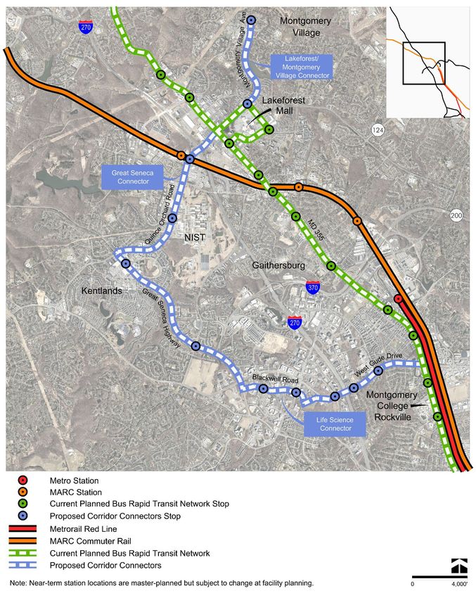
Figure 1 – Complete Proposed Network................................................................................................................................ 9
Figure 2 – Dedicated Bus Lanes Network, including Proposed Corridor Connectors ....................................................... 36
Figure 3 – Germantown and Clarksburg Dedicated Bus Lanes, Including Proposed Corridor Connectors...................... 38
Figure 4 – Life Sciences Connector ...................................................................................................................................... 40
Figure 5 – Lakeforest/Montgomery Village Connector, shown with the Great Seneca and Life Sciences Connectors .... 42
Figure 6 – Long-Term Vision................................................................................................................................................. 50
4
FRONT MATTER

ABOUT THE PLAN
Corridor Forward: The I-270 Transit Plan was added to Montgomery Planning’s work program at the request
of the County Council in spring 2019. The purpose of the Plan is to understand which of the numerous
corridor-serving transit options in the public sphere—including those that are master planned, studied by
others, or frequently requested—warrant pursuit when funding opportunities become available. Which
corridor-serving transit options support equitable access and sustainable growth as well as further the
county’s economic competitiveness? And which complement each other, creating an efficient, achievable,
and appropriately scaled transit network? Some options offer complementary benefits, while others offer
redundancy. Some options offer significant up-front costs in return for significant benefits, while others
offer both modest gains and modest costs. Which should move forward?

Today, the large list of corridor-serving transit options continues to grow, creating a challenge for
implementation. The county has master plans that recommend beneficial projects, which each remain at
various stages of study or design. As the public waits for these projects to advance, advocates have
requested, suggested, and innovated new potential transit options to fill existing gaps. While these new
options add to the rich dialogue about what the I-270 corridor’s transit-oriented future could be, they also
make it more challenging to understand where focus and resources should be directed. Corridor Forward
aims to advance transit beyond talk and into action by developing a lasting, achievable transit vision for the
I-270 corridor. The Plan employs a scenario-planning approach to help decisionmakers understand the
different purposes, benefits, constraints and costs of various transit options, how components of different
options can fit together to create a complementary transit network, and the potential order of
implementation for the recommended network.

CORRIDOR FORWARD IN CONTEXT
Corridor Forward was added to Montgomery Planning’s work program against the backdrop of the State of
Maryland’s Managed Lanes highway expansion efforts and increasing development demand for life
sciences uses in the county’s midcounty region. In spring 2019, the Maryland Department of
Transportation’s State Highway Administration (MDOT SHA) had yet to release its Draft Environmental
Impact Statement (DEIS) for its I-270 and I-495 Managed Lanes National Environmental Policy Act
(NEPA) Study, which evaluated the potential to add additional high-occupancy toll lanes on portions of I-
495 and I-270 through a public-private partnership (P3). At the time, regional stakeholders wondered if
and how transit could be supported by the proposed P3 given that the state had already eliminated various
transit options, including heavy rail, light rail, bus rapid transit (BRT), and bus-only managed lanes, from its
Alternatives Analysis (AA).

Separately, the staging provisions in the 2010 Great Seneca Science Corridor Master Plan (GSSC Master Plan)
were restricting property owners interested in constructing life sciences uses from moving projects forward.
The largest staging hurdle in the 2010 GSSC Master Plan—construction funding for phase one of the Corridor
Cities Transitway (CCT)—had no funding in the state’s FY 2020 Consolidated Transportation Program

                                                                                                               5
(CTP), suggesting the state would provide no further financial support for the transit project. The
Montgomery County Council reacted by requesting an amendment to the Plan’s staging provisions, which
resulted in the 2021 Great Seneca Science Corridor Minor Master Plan Amendment. Decisions about the CCT,
however, were to be informed by Council’s review of Corridor Forward, necessitating a comprehensive plan
amendment of the GSSC area after Corridor Forward’s approval and adoption.

Montgomery Planning initiated Corridor Forward in spring 2020, just as the COVID-19 pandemic emerged.
The pandemic, paired with increased financial support for the bio-technology industry, stimulated already
strong interest in life sciences development. Development pressure for life sciences uses increased as bio-
technology operations large and small worked to advance pandemic-related ventures. Transit use in the
pandemic, however, declined. Many transit-riding employees were either required to or chose to work from
home, resulting in reduced ridership and, in turn, service cuts. Reports about individuals impacted by
transit service cuts permeated local and national media streams, increasing the public’s awareness of just
how many individuals—including essential workers—depend on transit.

At the time of this writing, transit operators have begun restoring service, riders are returning, and the state
has indicated that the Managed Lanes project will provide financial support for transit. While reestablishing
normalcy may take time, many acknowledge that a return to business as usual may not be sufficient for the
county based on its goals for economic health, community equity and environmental resilience. Providing
high-quality transit along the I-270 corridor—if paired with the appropriate policies—will better position the
I-270 corridor and the county to achieve the county’s established policy goals.

The development of Corridor Forward also coincided with an update to the county’s general plan, referred
to as Thrive Montgomery 2050, which provides broad policy guidance and a framework for decisions about
land use, transportation, and related issues under local government influence. The policies and practices in
the Planning Board Draft of Thrive Montgomery 2050 seek to achieve three overarching objectives: economic
competitiveness, racial and social equity, and environmental resilience. The policy guidance and
overarching objectives of the Planning Board Draft of Thrive Montgomery 2050 informed the development of
Corridor Forward.

HOW TO READ THIS TEXT
Items defined in the glossary located within the Plan’s appendices are shown in bold blue typeface when
first mentioned in the Plan.

                                                                                                               6
CHAPTER 1 – EXECUTIVE SUMMARY
In 1961, the Washington National Pike, now known as Interstate 270, was envisioned as a transit corridor – a
vision further embraced by Montgomery County’s 1964 General Plan and reaffirmed through decades of
master plans. While many corridor residents and employees use and enjoy existing transit services along the
corridor today, a vision to serve the I-270 corridor with transit requires recommitment. Key midcounty and
upcounty transit connections need to be established to link the corridor cities of Gaithersburg,
Germantown, and Clarksburg to the county’s high-quality transit network. Transit access to neighboring
Frederick and Fairfax counties could also be improved to be more frequent, direct, and competitive.

Policymakers and the public have offered numerous transit options that could satisfy these needs, but with
so many options to consider, there is no shared perspective about which potential transit projects have the
most merit and where to focus resources. Planned concepts, like the Corridor Cities Transitway (CCT), have
partially advanced without full investment by stakeholders and funding partners, inviting the opportunity
for numerous adjustments, revisions, and delays. Additionally, the county’s historical growth policies, which
prioritized automobile travel, have ensured convenience for drivers, but have overshadowed the
implementation of high-quality transit. While most stakeholders agree that serving the I-270 corridor with
transit is a priority, it is unclear what this means or how it will be achieved.

In response, Corridor Forward: The I-270 Transit Plan offers a refocused vision for the corridor. It proposes a
transit network, which includes a near-term recommendation for dedicated bus lanes and a long-term
recommendation for an extension of Metrorail’s Red Line. The near-term network of dedicated bus lanes,
referred to as the Corridor Connectors, builds on existing master-planned projects, including the MD 355
and Veirs Mill Road Bus Rapid Transit (BRT) projects, to create a transit network that serves communities
and employment centers along the I-270 corridor. This Plan reenvisions the master-planned CCT as the
Corridor Connectors, a network of more buildable dedicated bus lanes, which connect I-270 corridor
communities to the county’s existing and planned rapid transit network.

The proposed transit network was determined through an iterative planning process, which began with the
identification of general stakeholder values and priorities pertaining to transit, as well as an inventory and
initial evaluation of potential transit options. Next, metrics were developed to consider the cumulative
benefits, costs, and risks of six compelling transit options retained for detailed analysis. Based on
performance, implementation, and policy considerations, components of three of the six transit options
were combined and subsequently evaluated to develop the proposed transit network.

THE PROPOSED NETWORK

Near-Term Dedicated Bus Lanes
This Plan recommends the MD 355 BRT and Veirs Mill Road BRT as the most crucial first steps in improving
transit accessibility along the I-270 corridor. Following implementation of these services, the Plan
recommends new dedicated bus lanes, referred to as the Corridor Connectors, to connect key activity and
employment centers to the county’s primary north-south rapid transit lines, as well as Metrorail and the
MARC Rail Brunswick Line.
                                                                                                              7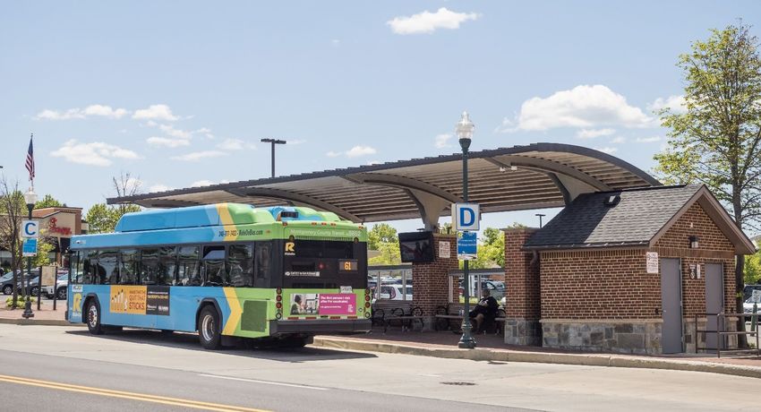
The complete proposed transit network, with additional dedicated bus lanes beyond the MD 355 and Veirs
Mill Road BRT services, is shown in Figure 1. This network augments the planned BRT routes in midcounty
and upcounty to maximize connectivity, reduce implementation obstacles, and unlock multiple
community-serving service patterns. The proposed transit network’s dedicated bus lanes can serve as
individual dedicated bus lanes (if implemented in a piecemeal fashion following the MD 355 and Veirs Mill
Road BRTs) and as a network, providing significantly improved transit connectivity for communities in the
midcounty and upcounty once they are fully constructed. Corridor Forward shifts the focus from single
branded services, like the CCT, to a flexible network of dedicated bus lanes that can support multiple
routing patterns. Dedicated bus lanes do not need to be restricted to a single purpose or route, and the
county does not need to wait to fund the full system to advance components of the proposed Connectors.

The Plan’s ultimate success is demonstrated through implementation of the proposed transit network. As
the network may be implemented incrementally, Corridor Forward suggests priorities for the order of
implementation, as well as strategies to advance implementation. The Plan’s highest priorities for
implementation are the MD 355 and Veirs Mill Road BRT services, followed by the Corridor Connectors in the
following order:

   •   The Germantown and Life Sciences Connectors
   •   The Lakeforest/Montgomery Village Connector
   •   The Great Seneca Connector
   •   The Manekin West Connector
   •   The Milestone/COMSAT East Clarksburg Connector

Long-Term Extension of the Red Line
In addition to the Corridor Connectors, the proposed transit network also includes a recommendation for a
long-term extension of the Washington Metropolitan Area Transit Authority’s (WMATA) Metrorail Red Line to
Germantown Town Center. This long-term extension is ambitious due to the additional detailed analysis
required, the magnitude of coordination, and the work that must be done within the core of the existing
Metrorail system, all of which must be addressed prior to advancing the recommendation. This Plan
identifies several specific factors that require coordination for the long-term extension to advance.

                                                                                                            8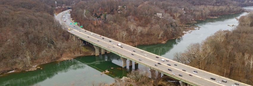
Figure 1 – Complete Proposed Network

                                       9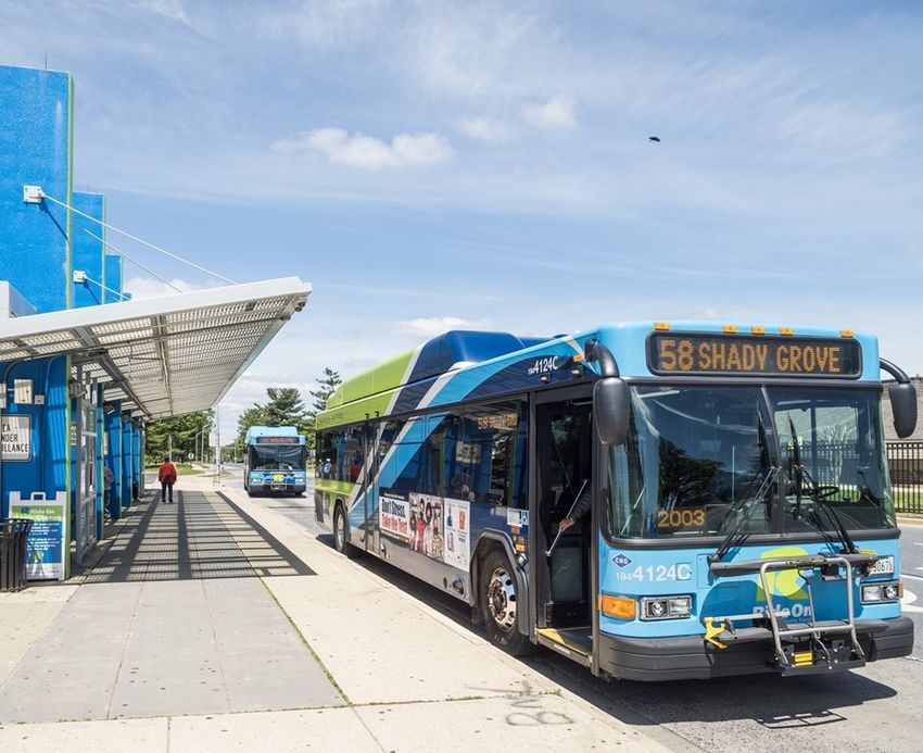
ADDITIONAL RECOMMENDATIONS
Beyond the proposed network, Corridor Forward offers additional recommendations that support the
proposed transit network and strengthen the potential to advance local and regional transit connectivity.
County actions accompany each of these recommendations, which are organized by priority and
champion—meaning which jurisdiction(s) would likely take the lead on advancing a recommendation given
the anticipated benefits. Table 1 explains how recommendations are organized. Table 2 provides the
complete set of recommendations that strengthen the proposed network and support regional
connectivity.

Advancing the I-270 corridor’s transit future is possible. Renewing the county’s commitment to transit will
require embracing policy trade-offs that ensure our transit investments result in efficient and competitive
service. If the county intends to achieve its economic, equity, and climate goals, priorities must be clear and
intentional.

Table 1 – Recommendation Structure
                                                         Priority
       Primary Recommendation                  Supporting Recommendation                 Future Need or Consideration

 Primary recommendations are the
                                           Supporting recommendations                Future needs or considerations are
 Plan’s foundational recommendations.
                                           strengthen the advancement and            recommendations that, while lower in
 These recommendations represent the
                                           quality of the Plan’s primary             priority, support long-term regional
 Plan’s ultimate vision for Corridor
                                           recommendations.                          connectivity.
 accessibility.
                                                        Champion
          Montgomery County                    Shared by County and Others                     Primarily Others

 Montgomery County government is the       Multiple parties within the region,       Montgomery County government can
 lead agency responsible for advancing a   including Montgomery County               cooperate and support the
 recommendation, and the county’s          government, are necessary to advance a    advancement of a recommendation, but
 constituents stand the most to gain       recommendation. Benefits are relatively   the lead stakeholder is not Montgomery
 from a recommendation’s                   distributed across various regional       County government. Montgomery
 advancement.                              stakeholders.                             County’s constituents stand to gain
                                                                                     from the recommendation, but benefits
                                                                                     may be greater for other parties.

                                                                                                                            10
Table 2 – Summary of Recommendations1, 2
Recommendation Priority Champion
A. Implement the network of dedicated bus lanes in the midcounty and upcounty, beginning
with the MD 355 BRT and Veirs Mill Road BRT followed by the Corridor Connectors.
In the long-term, work with local, state, and regional partners to advance the
recommendation for a Red Line Extension to Germantown Town Center. (Refer to Table 11,
Chapter 5.)
B. Convert existing general-purpose travel lanes to dedicated transit lanes on targeted streets
to maximize person throughput and improve the relative travel time competitiveness and
convenience of transit, including—but not limited to—the streets detailed in the right-of-
way table (Table 14). (Refer to Table 18, Chapter 6.)
C. Develop a new multimodal transit hub near the intersection of MD 124 and the CSX tracks as
part of implementation of the Red Line Extension. (Refer to Table 16, Chapter 5.)
D. Prioritize the provision of dedicated transit lanes and spaces for walking, bicycling and
other micromobility modes over auto capacity to maximize person throughput and improve
the relative travel time competitiveness and convenience of transit. (Refer to Table 18,
Chapter 6.)
E. Ensure safe and efficient access to planned transit stops for pedestrians, bicyclists, and
other micromobility modes. (Refer to Table 16, Chapter 5.)
F. Update relevant land use plans and guidelines to support master-planned transit facilities.
(Refer to Table 16, Chapter 5.)
G. Support the Great Seneca Transit Network. (Refer to Table 13, Chapter 5.)
H. Continue state-provided commuter bus service on I-270, making use of the Corridor
Connectors when diverting to bus stations in Montgomery County’s population and
employment centers via the Corridor Connectors. (Refer to Table 10, Chapter 4.)
11Recommendation Priority Champion
I. Maximize the travel potential of dedicated bus lanes. (Refer to Table 17, Chapter 6.)
J. Where beneficial and/or necessary, support the incremental implementation of dedicated
bus lanes. (Refer to Table 17, Chapter 6.)
K. Support the North Bethesda Transitway alignment as master-planned. (Refer to Chapter 5.)
L. Study extensions of the Purple Line to understand if and where extension(s) of the county’s
light rail service may be warranted. (Refer to Chapter 4.)
M. Support the long-term potential of the Maryland Transit Administration MARC Rail
Brunswick Line. (Refer to Table 7, Chapter 4.)
N. Promote strategic and equitable MARC Rail access by supporting new stations. (Refer to
Table 7, Chapter 4.)
O. Design and construct the American Legion Bridge to support rail transit. (Refer to Table 6,
Chapter 4.)
P. Explore a direct transit connection between the recommended WMATA Metrorail Red Line
terminus and Frederick County. (Refer to Table 8, Chapter 4.)
1
The order of the recommendations presented in the table is not intended to suggest a rank of importance. The priority column should be used
to understand the importance of each recommendation relative to other recommendations.
2
Some recommendations contained in this Plan could require inter-jurisdictional cooperation, as the boundaries of that portion of the Regional
District within Montgomery County are prescribed in the Land Use Article of the Annotated Code of Maryland.
While this Plan focuses on infrastructure and not operational improvements, it also supports two additional
key services as noted in recommendations G and H. First, the Plan supports the implementation of the Great
12Seneca Transit Network, prioritizing investments that increase frequencies and provide meaningful travel
time benefits for transit users. This network, proposed by the Montgomery County Department of
Transportation (MCDOT), envisions a series of new local bus routes serving the Great Seneca vicinity. These
routes are enhanced with operational improvements such as transit signal priority, queue jumps, and
express bus lanes. Second, the Corridor Connectors can be used by commuter bus services to support off-
highway diversions to key points of demand. In this regard, the proposed infrastructure becomes
multifunctional. Also, while not studied extensively in this Plan, recommendation K discusses continued
support for the North Bethesda Transitway.
Corridor Forward extensively studied MARC Rail Enhancements as contemplated in the Maryland Transit
Administration’s (MTA) MARC Cornerstone Plan (2018). Recommendations M and N call for continued
support of the long-term potential of MARC Rail. This plan maintains the recommendation to obtain right-
of-way for additional mainline track during the development process and advocates for already master-
planned stations at Shady Grove and White Flint.
13CHAPTER 2 - PREMISE
YESTERDAY’S TRANSIT VISION STUCK IN TODAY’S GRIDLOCK
In 1961, the National Capital Planning Commission and the National Capital Regional Planning Commission
jointly released A Policies Plan for the Year 2000. To avoid urban sprawl, the document proposed a “concert
of policies” for the capital region that focused growth along radial corridors extending from Washington,
DC. In support of this vision, the document offered two specific transportation policies:
• Limit expansions of the freeway system beyond what was planned; and
• Promote greater reliance on transit.
Montgomery County embraced the vision of the 1961 A Policies Plan for the Year 2000 and adopted the 1964
General Plan, known as the Wedges and Corridors Plan, to establish development policies that aligned with
the regional planning framework, specifically focusing growth within new corridor cities supported by rapid
transit. The vision for corridor-focused, transit-oriented development has endured in subsequently adopted
master plans, sector plans, and functional plans, and was reaffirmed in the Planning Board Draft of Thrive
Montgomery 2050. These plans were successful in directing growth and development to the corridor cities,
including Gaithersburg, Germantown, and Clarksburg, but the transit vision of these plans has yet not been
fully achieved.
Today, corridor residents and employees traveling between various points of demand in Montgomery
County, Frederick County, Northern Virginia, and Washington, DC, enjoy access to the WMATA Metrorail
system, which is one of the nation’s premier urban transportation systems, as well as the MARC Brunswick
Line, which leverages private infrastructure to improve public accessibility for the region primarily during
the rush hour. Residents and employees also enjoy access to established regional and local bus services
provided by WMATA, the Maryland Transit Administration (MTA), and Montgomery County’s Ride On.
While constructing and operating these services is no small feat, the Wedges and Corridors Plan
recommended connecting its planned corridor cities by a large high-frequency rapid transit network
separated from traffic. But today, the MARC Brunswick Line mainly provides rush hour service to
Gaithersburg and Germantown, and high-frequency, premium transit service provided by WMATA’s
Metrorail terminates midcounty at Shady Grove. While rapid transit connections to Clarksburg are planned,
they are not yet implemented. Transit connectivity among the corridor cities and neighboring jurisdictions
is limited and inefficient.
The long-planned transit vision for the I-270 corridor remains relevant, but it is stuck in gridlock. The I-270
corridor experiences more than twice as many automobile commuters every morning compared to transit
riders, and traffic congestion on our roadway network has—and continues to—intensify. Jobs located within
the I-270 corridor’s activity centers are, on average, 80 percent more accessible by car than by transit,
assuming a 45-minute commute.
14There is no single reason that the county’s transit infrastructure did not keep pace with its physical growth,
but stakeholder and public coordination during the development of Corridor Forward illuminated three key
themes, addressed in various chapters and recommendations of the Plan:
• There are many corridor-serving transit options in the public sphere, but to date, there is no
consensus about which combination of options has the greatest merit, making it challenging to
effectively focus resources and planning. This topic is addressed in Chapters 3 and 4.
• Planned concepts are often advanced without strategic or flexible implementation strategies,
inviting opportunities for perpetual tweaks and reenvisioning. This topic is addressed in the
narrative of Chapter 5 and recommendations of Chapter 6.
• Historically, the county’s policies supported convenient automobile travel without a comparable
emphasis on implementing high-quality transit. Commitment is required to not only implement
transit but ensure that it is successful and competitive with driving. This topic is addressed
throughout the Plan’s recommendations, but significant focus is provided on this issue in the
recommendations in Chapter 6.
THE PURPOSE AND PROCESS OF CORRIDOR FORWARD
Corridor Forward addresses these themes by:
• Inventorying various corridor-serving transit options circulating in the public sphere;
• Narrowing the larger menu of options to six transit options retained for detailed analysis;
• Comparing the combined benefits, challenges, and risks of the retained transit options;
• Recommending a transit infrastructure network based on strategic, financial, economic, and
implementation performance as well as policy considerations;
• Supporting a recommendation for a new long-term transit option with significant merit; and
• Developing strategies for implementation that prioritize components of the transit network.
Corridor Forward also offers recommendations that support the transit network and strengthen the
potential for future cooperation with neighboring jurisdictions.
ALL ABOARD…BUT TO AND FROM WHERE?
Spanning from Frederick County to Fairfax County, the I-270 corridor serves a range of trips. While
approximately 61 percent of Montgomery County residents work within Montgomery County itself, many
Montgomery County residents travel to Washington, DC, and other locations across the region, such as
Prince George’s County, Fairfax County and Arlington County.
People traveling along the corridor typically do not travel directly from end to end. In fact, only four percent
of commuters from Frederick County commute to Fairfax County, and less than one percent of commuters
from Fairfax County commute to Frederick County.
Simply put, there is not significant travel demand for trips between the perceived “ends” of the corridor.
Most travelers are moving to and from corridor communities and employment centers that are less distant.
15For example, a greater number of afternoon peak hour trips are made between Frederick County and
Germantown (approximately 4,000) than Frederick County and Bethesda/Chevy Chase (approximately
1,000). For this reason, the Plan identifies key potential service areas where corridor communities could be
better integrated into and supported by the county’s planned and existing high-quality transit network:
1. Upcounty and points north, including Germantown, Clarksburg, and Frederick County
2. The heart of midcounty, including Montgomery Village, Great Seneca, and Gaithersburg
3. Northern Virginia, including Tysons
Chapter 3 inventories local and regionally-oriented transit options that serve these three areas—which have
different geographic spans, characteristics, and needs. Chapter 3 also justifies why a comparative analysis is
appropriate despite these areas’ differing characteristics and needs.
TRANSIT VALUES AND METRICS
The Corridor Forward planning process included the identification of stakeholders’ values and priorities
pertaining to transit, which were used to develop metrics that highlight the benefits and drawbacks
associated with different transit options. Corridor Forward solicited feedback on values and priorities from
various agencies, jurisdictions, stakeholders, and the community through meetings and a Transit Values
Questionnaire, which was widely advertised and promoted (more information provided in the Plan’s
Community Outreach Appendix). This feedback, paired with values identified through the outreach and
engagement process for Thrive Montgomery 2050, resulted in a single Plan goal that reaffirms the values of
the county’s general plan update effort, shown in Table 3.
Table 3 – Corridor Forward Goal and Values
Corridor Forward Goal:
Advance a transit network that:
Serves high-demand origin and destination pairs, balancing the costs of implementation
with projected benefits. Transit should serve existing and future mobility needs, providing a
safe, comfortable, and convenient transportation option for people traveling to work or
Strategic Connections
school, running errands, or making other types of trips. While many transit options may be
attractive, one must consider what may be feasible given financial, political, and geographic
constraints.
Enables existing development and master-planned communities to realize their potential
as livable and economically vibrant places. To stay economically competitive in the region,
Economic Health
Montgomery County needs to ensure it provides accessible, high-quality transit to all residents
and to people commuting within and to Montgomery County.
Aligns with the county’s social equity goals and principles. Transit provides mobility
options for those who may not be able to afford a personal vehicle, ride-hailing services, or
Community Equity
anticipated autonomous subscription-based mobility services. Transit can and should serve
all populations—not just the privileged.
Operates sustainably and reduces negative environmental impacts. Montgomery County
aims to reduce greenhouse gas emissions 80% by 2027 and 100% by 2035. Transportation
plays a critical role in achieving this environmental goal with transportation-related emissions
currently accounting for over 40% of the greenhouse gas emissions in Montgomery County. All
Environmental Resilience
things being equal (i.e., assuming energy is generated by the same source and transit and
personal vehicles are serving the same number of passengers), transit is a more sustainable,
less energy-intensive transportation mode that can help the county meet its environmental
goals.
16Beyond the values encompassed by the Plan’s broad goal, implementation and practical costs were
reoccurring themes among stakeholders and the public. With consultant support, Montgomery Planning
developed a series of metrics to capture both strategic values-based benefits and practical considerations.
The complete list of comparative metrics depicts a holistic picture of planning-level costs, benefits, and
risks across four dimensions:
• Strategic Dimension: How does an option or network scenario broadly support county and regional
policies and goals, including the values addressed in Corridor Forward’s goal? Example metrics:
increase in job access for Equity Focus Area communities; reduction in greenhouse gas emissions; new
systemwide transit trips.
• Financial Dimension: What are the financial impacts of each corridor option and network scenario?
Example metrics: capital and operating costs based on national benchmarks; planning-level land
acquisition costs.
• Economic Dimension: What is the societal value of each option and network scenario? Example
metrics: monetized value of reduced collisions and improved health.
• Implementation Dimension: What risks are associated with the delivery and operations of each
option and network scenario? Example metrics: operating model risks and potential historic and
environmental impact risks.
17CHAPTER 3 – OPTIONS INVENTORY
WHEN EVERYTHING IS A PRIORITY…
Several corridor-serving transit options have emerged over the years, each with their own merit, spanning
various geographic extents and fulfilling different needs. For example, enhanced MARC Brunswick Line
service supports several communities between Frederick and Washington, DC, while the Corridor Cities
Transitway (CCT) serves more targeted midcounty and upcounty geographies. Because there is no single
planned service that can meet all existing and future needs, it is important to consider the benefits, costs,
and risks of each option to inform county priorities.
Some may suggest that evaluating transit options serving different markets is an exercise with little value,
as doing so does not yield a direct comparison: “It is simply comparing apples and oranges.” But there are
occasions when one peers into the fruit basket only to be greeted by apples and oranges, each vying for
attention, and a choice needs to be made about where to take the first bite.
Also, if each transit option can significantly improve corridor access and livability, why not simply
recommend them all? This approach is not advisable for several reasons. First, it is not financially realistic to
expect that the public sector can construct and operate every option inventoried. Recommendations in
county functional plans also have the weight of policy intent. Recommending transit options that would
garner minimal implementation interest following Plan approval could degrade public faith in long-range
planning. Next, some options include overlapping service areas. While some redundancy can be beneficial
for reliability purposes, too much redundancy is an inefficient use of limited resources. Finally—and perhaps
most importantly—the overall benefits of some options may exceed others. Prioritizing and recommending
the best options helps focus limited time, energy, and resources.
Montgomery Planning developed an initial menu of transit options in the public sphere and performed a
preliminary off-model assessment of these options to identify candidates that warranted more detailed
analyses. A description of that assessment can be found under the Curated Menu of Transit Options for Study
header. The Plan’s initial menu of options is summarized in Table 4 and described in greater detail in the
Plan’s Appendix. The Plan’s Appendix (Appendix 2 – Options & Pre-Screening Analysis) also contains
supplementary information about the characteristics of associated transit modes, which are briefly defined
below.
• Bus Rapid Transit: a bus that primarily travels in dedicated lanes or guideways, which allow the bus
to run uninhibited by traffic; additional amenities can include at-grade boarding, off-board fare
collection, and distinct high-quality infrastructure and branding.
• Commuter Rail: a passenger train service that connects centralized points of demand with outlying
areas; other typical characteristics include station-to-station based fares, greater distances between
stops, and the potential to purchase multiple trips as a package.
18• Metrorail: an electric rail passenger service typically used to support high volumes in urban areas;
other typical characteristics include high-platform loading, high frequencies of service, and higher
acceleration speeds compared to other modes.
• Light Rail Transit: a passenger train service that is typically electric used to support greater
separation between stops than Metrorail but closer separation than commuter rail; other
characteristics include the ability operate at grade on-street or off-street (although service is
segregated from other traffic).
• Monorail: an electric vehicle passenger service running on a single beam or guideway that is
typically elevated on columns; other typical characteristics include high frequencies, and in the U.S.,
shorter spans of operation.
• Commuter Bus: a regional bus service that primarily supports connections between outlying areas
and centralized points of demand; other typical characteristics include limited stops, significant
distances between stops, and the ability to purchase multiple trips as a package.
Each of the modes listed above, as well as local bus, has a role to play in serving a hierarchy of mobility
needs. This hierarchy is defined by two spectrums:
• Access-efficiency spectrum: Some modes typically provide frequent and closely spaced stops,
while others offer more limited stop opportunities. Modes that typically provide a significant number
of stops offer greater accessibility to riders by providing more opportunities for convenient
boardings and alightings at points of demand. Modes that limit stops to only the most significant
points of demand provide greater efficiency to riders by reducing travel times.
• Span of service spectrum: Some modes typically provide greater spans of service, traversing
regions rather than localities. Other modes provide more locally-focused service.
At one extreme, modes like commuter rail tend to span greater distances, have fewer stops, and can
sometimes depend on first- and last-mile supplementary services like local bus transit or park and ride.
Modes like commuter bus are similar but offer the flexibility to accommodate better access (i.e., a greater
number of stops), typically near initial or terminal points of demand; however, these buses typically do not
have the advantage of running in dedicated service and are thus less efficient. On the other extreme, local
buses typically provide a greater number of stops (i.e., more access) but are less efficient. This mode
typically follows shorter routing patterns. Metrorail and BRT modes fall somewhere in the middle of the
access/efficiency and span of service spectrums. In the United States, monorail and light rail systems tend
to balance access and efficiency and provide more urban-oriented service; however, beyond the United
States these modes have been employed in regional contexts as well.
INITIAL MENU – TRANSIT OPTIONS INVENTORY
Table 4 summarizes the options inventoried by Corridor Forward. For additional context on these options,
please refer to the Plan’s Appendix.
19Table 4 – Initial Menu of Transit Options
Primary/General
Service From To
Option Name Mode Corridor Notes
Type (North) (South)
Alignment
MD 355, with
Assumed as constructed
Bus Rapid Snowden Farm
MD 355 BRT Local Clarksburg Bethesda in all Plan technical
Transit alignment north
work
of Germantown
Assumed as constructed
Veirs Mill Road Bus Rapid Rockville
Veirs Mill Road Local Wheaton in all Plan technical
BRT Transit Town Center
work
MD 187 or Master-Planned, but not
North Bethesda Bus Rapid Tuckerman White Flint or assumed as constructed
Local Rock Spring
Transitway Transit Lane/Rock Spring Grosvenor in any Plan technical
Drive work1
Tysons-Rock
Old Georgetown Could potentially
Spring North Local-
Bus Rapid Road & I-495 operate as a service leg
Bethesda Regional Rock Spring Tysons
Transit /American Legion of the North Bethesda
Transitway Hybrid
Bridge Transitway
Extension
Great Seneca/ Included as designed in
Corridor Cities
Bus Rapid Germantown/ the MTA 2017
Transitway Phase Local Clarksburg Shady Grove
Transit Clarksburg Environmental
1&2
Roadways Assessment (EA)
15-minute headways
during rush hour and
Enhanced MARC Commuter Frederick/ Union
CSX Rail Corridor Regional additional stop
Rail Rail Martinsburg Station
locations at White Flint
and Shady Grove
Limited Service frequencies
Red Line Germantown
Metrorail CSX Rail Corridor Stop Local Shady Grove assumed to match
Extension Town Center
Service existing levels
Capital Crescent
Trail/River Service frequencies
Purple Line Light Rail Bethesda
Road/I-495/ Regional Tysons assumed to match
Extension Transit Station
American Legion planned levels
Bridge
Could potentially
I-270 Corridor Light Rail
I-270 Regional Gaithersburg Bethesda connect to Purple Line
Light Rail Transit
infrastructure
Frederick-Shady Downtown Assumes MDOT Monorail
Monorail/
Grove Rail I-270 Regional Frederick Shady Grove Feasibility Study
Light Rail
Connection Vicinity alignment
Silver Spring;
Managed Lanes Enhanced Downtown Includes three variants
Downtown
Enhanced Commuter I-270 & I-495 Regional Frederick with different southern
Bethesda; or
Commuter Bus Bus Vicinity termini
Tysons
1
Similar to the Corridor Cities Transitway, the North Bethesda Transitway is in the National Capital Region Transportation Planning Board’s
(TPB) Constrained Long-Range Plan, but it was not included as background in any Plan technical work because an associated extension was
under consideration for isolated detailed analysis. Ultimately, the extension option was not retained for detailed analysis and the North
Bethesda Transitway was not included in the Plan’s technical work.
20OTHER MODES
During the Plan’s development, stakeholders requested an examination of maglev and Personal Rapid
Transit (PRT) technologies. Maglev trains—or magnetic levitation trains—use magnetic force for propulsion.
These trains can run as monorails or can run on two rails. Currently, the top speed of an operating maglev
train is approximately 270 miles per hour. The high speeds and costs associated with maglev suggest it is
most appropriate for limited-stop service between locations with significant housing and employment
density. As of this writing, there are no maglev trains operating in the United States and the Federal Railroad
Administration (FRA) has paused its review of a proposal to connect Washington, DC, and Baltimore by
maglev with one intermediary stop at Baltimore-Washington International Airport.
PRT cars, sometimes referred to as pods, are driverless vehicles that run on a series of dedicated
guideways—either rail beams, rail tracks, or separated roadways. Existing systems typically seat between
three and six passengers per vehicle, although the oldest—and only—PRT system in the United States
located in Morgantown, WV can seat up to 20 passengers per car. While PRT systems feature defined
stations like other forms of transit, they generally offer point-to-point services without intermediary stops.
Should these two modes be of interest to future Planning Boards and Councils, specialized and third-party
expertise will be needed to assess the viability of these systems, their benefits, their costs, and their typical
applications. As stated, the premise of Corridor Forward is to inventory and prioritize existing options in the
public sphere, including modes that exist in county-approved plans, modes considered in ongoing work by
Montgomery County and the State of Maryland, and modes that have been widely and successfully
implemented in transit systems across the nation.
CURATED MENU OF TRANSIT OPTIONS FOR STUDY
Corridor Forward employed a pre-screening analysis to identify and advance six options from the initial
menu for more detailed analysis. The pre-screening method posed five questions that could be answered
with off-model tools and data to assess, at a preliminary level, each option’s potential:
• Are anticipated travel times between key destinations served by the option competitive with driving
and other transit modes based on an off-model assessment?
• How many people will have walking, transit, or driving access to the option’s conceptual station
locations?
• How many jobs are located within walking distance or transfer transit trip from the option’s
preliminary stations?
• Does the option serve planned growth?
• Are the option’s proposed stations accessible by walking, transit, or driving access to communities in
the county with recognized equity needs?
Generally, the rail options performed better in the pre-screening analysis at providing competitive travel
times and the two “Bethesda to Tysons” options performed poorly regarding serving communities with a
greater need for equitable access to transit and jobs. To account for differences in geographic span, the pre-
screening analysis identified top performing options across varying degrees of quality and geographic
21coverage to provide a refined menu. Per Planning Board direction, the top performing options advanced for
further analysis were:
• Enhanced MARC Rail Service
• Red Line Extension to Germantown Town Center
• Corridor Cities Transitway
• Purple Line Extension to Tysons
• Frederick-Shady Grove Rail Connection
• Managed Lanes Enhanced Commuter Bus - Tysons Terminus
Corridor Forward recognizes that the MD 355 BRT and Veirs Mill Road BRT are high priority projects and
recommends that these projects should be implemented as soon as possible. For this reason, Corridor
Forward assumes both projects are constructed and existing in the Plan’s detailed analysis.
Two services were eliminated from the initial menu: Rock Spring-to-Tysons BRT Connection and I-270 Light
Rail. The latter option included segments that overlap both existing WMATA Metrorail Red Line and MARC
Rail service and performed poorly in pre-screening due to these redundancies. The Tysons-Rock Spring
North Bethesda Transitway Extension option was outperformed slightly by the Purple Line Extension and
significantly by the highway-running Managed Lanes Enhanced Commuter Bus option, which serves more
communities. As such, it did not advance. The North Bethesda Transitway did not advance as Montgomery
Planning did not envision changes to the service. While it was not included as background in the Plan’s
technical work, the Plan supports the North Bethesda Transitway as master-planned (discussed further in
Chapter 5).
22You can also read