Broomhaugh and Riding Neighbourhood Plan 2023 - 2036 Submission Draft - January 2023
←
→
Page content transcription
If your browser does not render page correctly, please read the page content below
Broomhaugh and Riding Neighbourhood Plan
              2023 - 2036
             Submission Draft
                January 2023
Broomhaugh and Riding Neighbourhood Plan: Pre-Submission Draft (January 2023)

Contents
     Foreword                                                                  x

  1. Introduction                                                              x
     Background to neighbourhood planning                                      x
     Planning context                                                          x
     Background to the Broomhaugh and Riding Neighbourhood Plan                x

     Next steps                                                                x
  2. Background to Broomhaugh and Riding Parish                                x
     A brief history of the parish                                             x
     Population and housing                                                    x
     Employment                                                                x
     Access to services and facilities                                         x
     Natural, historic and built environment                                   x
     Key issues for our neighbourhood plan                                     x

  3. Vision and objectives                                                     x
     Vision                                                                    x
     Objectives                                                                x

  4. Planning policies                                                         x
     Introduction                                                              x
     Sustainable development and climate change                                x
        Zero carbon parish                                                     x
        Sustainable location of new development                                x
        Sustainable construction                                               x
        Standalone renewable energy proposals                                  x
        Electric vehicles                                                      x
     The built, historic & natural environment and our thriving community      x
        Design                                                                 x
        Heritage                                                               x
        Natural environment                                                    x
        Local green space                                                      x
        Protected open space                                                   x
        Homes                                                                  x
        Services and facilities                                                x
        Local economy                                                          x
        Accessibility                                                          x
        Sustainable transport                                                  x

  5. Community actions                                                         x
        Introduction                                                           x
        Built environment                                                      x
        Natural environment                                                    x
        Dark skies                                                             x

                                                                                   2|P age
Broomhaugh and Riding Neighbourhood Plan: Pre-Submission Draft (January 2023)

  Transport                                                              x
  Sustainable development and climate change                             x
  Health and wellbeing                                                   x
  Local economy                                                          x

Acknowledgements                                                         x

Appendix 1: Summary of the natural environment of the parish             x
Appendix 2: Designated heritage assets within the parish                 x

                                                                             3|P age
Broomhaugh and Riding Neighbourhood Plan: Pre-Submission Draft (January 2023)

Foreword
The Broomhaugh and Riding Neighbourhood plan sets out a vision, objectives and policies for our
neighbourhood area for the period to 2036. It builds on the parish survey of 2021 and addresses the
challenges and opportunities we face as a community in terms of sustainability and climate change,
protecting and enhancing our natural environment, ensuring continuation and improvement of our
facilities and services, includes accessibility and transport and a commitment to provide housing to
achieve a more balanced demographic. Once approved by the community and adopted by
Northumberland County Council it will become a formal part of planning policy for our parish.

However, the plan is more than a planning document as it includes a set of community actions that sit
alongside the policies and reflect issues identified by local residents during the consultation work for
the plan.

The previous Broomhaugh and Riding Parish Plan (2002) resulted in real practical action including, for
example, traffic safety measures (though it has taken until this year for the pedestrian crossing on the
main road to be installed); the Mill pond work has been started with a view to creating an improved
amenity area, particularly for schoolchildren; heritage trail boards have been installed; and the station
improved visually with flower tubs and the rail company restored the footbridge. We hope that many
of you will get involved in turning our new community actions into reality too.

On behalf of the parish council, I would like to thank the members of the steering group who have led
the development of the plan. I would also like to thank the residents of our parish who have attended
meetings, completed surveys and made sure that their views are incorporated in the plan.

The parish council fully endorses the Neighbourhood Plan – we hope you can too.

Christine Howe
Chair Broomhaugh and Riding Parish Council

                                                                                             4|P age
Broomhaugh and Riding Neighbourhood Plan: Pre-Submission Draft (January 2023)

1. Introduction

      Background to neighbourhood planning
1.1   Neighbourhood planning is a right for communities introduced through the Localism Act 2011.
      Neighbourhood plans are community-led, prepared by parish councils and in areas without
      parish councils they are prepared by neighbourhood fora. Broomhaugh and Riding Parish
      Council is responsible for the preparation of this plan. Neighbourhood plans set out guidance
      on how new development will be managed. They do this by creating land use ‘planning policies’.
      Plans can deal with a wide range of issues like housing, employment, heritage and transport. In
      some cases, they may only focus on one or two issues that are of particular importance in a
      local area. Policies within neighbourhood plans cannot block development or support less than
      already committed in the statutory development plan. What they can do is shape where that
      development will go and what it will look like.

1.2   Neighbourhood plans can also cover issues which are not related to the use and development
      of land. They can provide a useful document in which a parish council can establish priorities
      for action to improve their area. These are often referred to as ‘community actions’ (section 5
      of this plan includes the community actions which apply to our parish). However, the main
      purpose of a neighbourhood plan is to set policies for the use and development of land.

1.3   Once a neighbourhood plan has been examined by an independent examiner, agreed at the
      referendum stage by the local community and ‘made’ (brought into legal force) by the local
      planning authority, it becomes part of the statutory development plan. Planning law requires
      that planning applications are determined in accordance with the development plan, unless
      material planning considerations indicate otherwise.

      Planning context
1.4   As they are part of the development plan, neighbourhood plans must be prepared in accordance
      with legal requirements. The way in which neighbourhood plans are prepared and the policies
      they contain are tested by an independent examiner who assesses whether the plan meets the
      ‘basic conditions’ to ensure they are legally compliant. Neighbourhood plans must:
          • Have regard to national planning policy and guidance;
          • Be in general conformity with the strategic policies of the development plan;
          • Contribute to the achievement of sustainable development; and
          • Be compatible with legal obligations.

      National planning policy and guidance
1.5   National planning policy and guidance is set out in the National Planning Policy Framework
      (NPPF) and National Planning Practice Guidance (NPPG) respectively.

      Development plan
1.6   The development plan for Broomhaugh and Riding Parish comprises the Northumberland Local
      Plan which was adopted by the Northumberland County Council (NCC) in March 2022. The
      Broomhaugh and Riding Neighbourhood Plan (‘the plan’) has been informed by the planning
      policies contained within the local plan and its evidence base.

      Sustainable development
1.7   The purpose of the planning system is to help achieve sustainable development as defined by
      the NPPF. This specifies that the presumption in favour of sustainable development should be

                                                                                         5|P age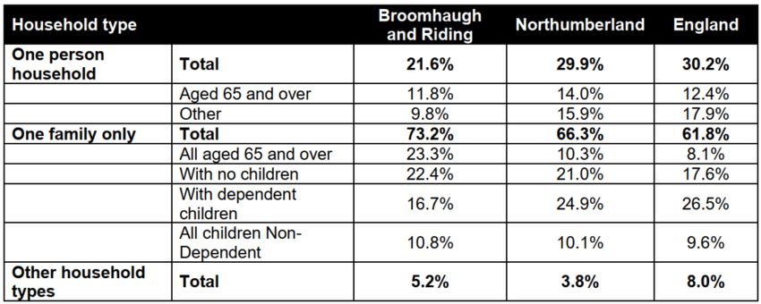
Broomhaugh and Riding Neighbourhood Plan: Pre-Submission Draft (January 2023)
the basis for every plan and every planning decision. In brief, ‘sustainable development’ is about
growth which delivers economic, environmental and social progress for this and future
generations. The basic conditions statement, that accompanies this submission plan, explains
how the implementation of the plan is expected to contribute to sustainable development.
Legal obligations
1.8 Neighbourhood plans must be compatible with legal obligations, specifically strategic
environmental assessment (SEA) regulations and habitats regulations, through an appropriate
assessment (AA). The SEA is a way of ensuring that the environmental implications of policies
are taken into account before plans are brought into force. The AA process aims to ensure that
the plan will not result in significant damage to internationally important nature conservation
sites.
1.9 NCC provided a screening opinion on whether a SEA and/ or AA was required for the plan. The
conclusion of the screening opinion for the SEA was that based on the characteristics of the
draft neighbourhood plan and the area characteristics, in the opinion of NCC, the plan is unlikely
to have significant effects on the environment and SEA is therefore not required. The HRA
screening opinion was that the draft plan would not have a likely significant effect on European
Sites within 10km of the plan boundary, either alone or in combination.
Background to the Broomhaugh and Riding Neighbourhood Plan
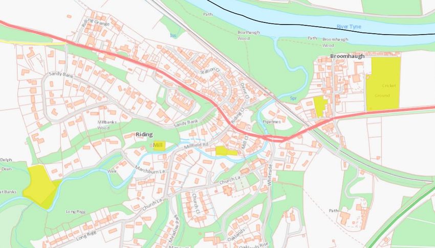
1.10 Broomhaugh and Riding Parish (figure 1) was designated as a neighbourhood area, for the
purposes of neighbourhood planning, on 21 October 2020. Following the area designation, the
parish council established six working groups and a steering group to lead the plan preparation
process. The steering group has seven members, a mixture of parish councillors and local
residents.
Figure 1: Neighbourhood area
6|P age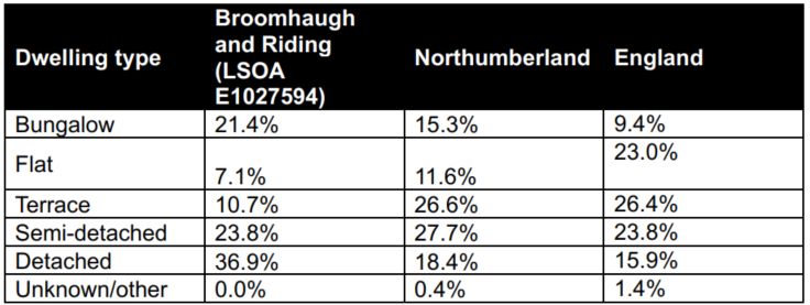
Broomhaugh and Riding Neighbourhood Plan: Pre-Submission Draft (January 2023)

1.11 To inform the preparation of the neighbourhood plan two early engagement activities have
     taken place:
       •     Parish residents survey – January and February 2021;
       •     Engagement on vision and objectives as well as possible themes for planning policies
             and community actions during November and December 2021. The local community
             were asked to provide feedback on the outcome of the work of the six working groups.

1.12 The early engagement and evidence work informed the preparation of a pre-submission draft
     neighbourhood plan, which was subject to consultation for six weeks between 1 November and
     13 December 2022. This submission draft plan is the result of the engagement and evidence
     work. It identifies:
      • The context in which the plan has been prepared – an overview of Broomhaugh and Riding
          Parish, the opportunities and challenges for the plan to address;
      • A positive vision and objectives for the future of the parish;
      • How the vision and objectives of the plan will be delivered through planning policies i.e.
          the policies that will be used to determine planning applications within the plan area –
          providing a framework for sustainable development; and
      • How the vision and objectives of the plan will be delivered through community actions
          i.e. measures which are intended to encourage action and influence decisions taken by
          relevant bodies.

1.13 The period covered by the plan is to 2036. This aligns with the Northumberland Local Plan (local
     plan). During this period, the effectiveness of the policies within the neighbourhood plan and
     the delivery of the community actions will be monitored. The plan will be reviewed and updated
     where required. This submission plan is a revised version of the pre-submission draft plan
     (November 2022). It has been amended to take account of the comments received. A
     consultation statement has been prepared which sets out how engagement has informed the
     preparation of the plan. This, alongside the background information and evidence documents
     that have informed the preparation of the plan, are available online at
     www.ridingmill.org/neighbourhood-plan/

      Next steps
1.14 The plan must be subject to independent examination to ensure the legal requirements of plan
     preparation have been met. NCC will arrange the appointment of an independent examiner
     and for this submission draft plan to be available for consultation for a period of at least six
     weeks. It is expected that the examination will be conducted by way of written representations.
     The examiner may choose to include a public session to inform their report, but this is not a
     requirement.

1.15 Once completed, the examiners report will be published by NCC. The report must contain one
     of three recommendations:
           • Proceed to referendum without modifications;
           • Proceed to referendum with minor modifications; or
           • Not proceed to referendum.

                                                                                          7|P age
Broomhaugh and Riding Neighbourhood Plan: Pre-Submission Draft (January 2023)

2. Background to Broomhaugh and Riding Parish
      A brief history of the parish
2.1   Riding Mill stands on the south bank of the Tyne sixteen miles west of Newcastle and five east
      of Hexham. In its present form the village is really a Victorian creation, incorporating the ancient
      hamlets of Broomhaugh and Riding, on the east and west banks of the March Burn, which flows
      from the south-west to join the river.

2.2   Prehistoric man was clearly active in the well-wooded and fertile middle Tyne valley, and the
      Romans settled hereabouts as well, having built a major wall a few miles to the north with its
      major supply-base at Corbridge, only three miles to the west. Their road from Corbridge to York
      – Dere Street – passes through the village; it can be traced as a grassy bank in the fields to the
      west and is still there as a road to the east. The so-called ‘Roman Bridge’ across the March Burn
      is really a 16th or 17th centuries packhorse bridge, although there was probably a real Roman
      one nearby. The oldest visible feature near the village is the Norman motte-and-bailey castle
      of Styford on the north bank of the river, now just a grassy hump, but once the power base of
      the Barony of Bolbec. As the centuries passed the earthwork castle seems to have been
      replaced by Styford Hall quarter of a mile to the east; the village of Styford grew up on the low-
      lying land near the Hall.

2.3   Meanwhile, on the south bank, the hamlets of Broomhaugh and Riding developed during the
      medieval period, not the happiest of times – there were periodic visits by Scots who had
      unfortunate incendiary tendencies. Even after the Union of the Crowns brought peace between
      the nations in 1603, local lawlessness and family feuds continued. Bastle houses – thick-walled
      defensible farmhouses in which the owner lived on the first floor – are testimony to this period.
      Two survive in Broomhaugh – Broomhaugh Farmhouse and Stable End – and the oldest part of
      the Dower House in Riding is probably one as well. The Manor House is also of 17th-century
      origin, and the Wellington Inn – once the Riding House – is dated 1660 and was built by Thomas
      Errington (although its doorhead initials of ‘T.E’ were later altered to T.B.’). It became notorious
      a few years later as the claimed meeting places of covens of witches – a lurid account of their
      meetings was given at the Morpeth Quarter Sessions in 1673, but the accused ladies were
      apparently acquitted. The building was altered and enlarged in the 18th and 19th century; its
      original windows have lost their mullions, but two good 17th-century fireplaces survive on the
      first floor. Little survives of the complex of farm buildings on the north, which had a gingang or
      horse-engine house. Riding Farm, at the west end of the village, retains a fine example. The
      Mill that gave its name to the village faces the Inn; there was a corn mill here since at least the
      medieval period but the present building, converted into a house in 1972, is of late 18th or early
      19th century date.

2.4   The great flood of 1771 seems to have destroyed the village of Styford; its inhabitants probably
      moved to Broomhaugh, set more safely on higher ground on the opposite bank of the Tyne
      beyond a ford, which finally fell out of use when the construction of the modern pumping
      station a few hundred yards downstream raised the level of the river by a couple of feet. The
      village street of Broomhaugh was once known as ‘Styford Street’ and retains some attractive
      old buildings. Outside Broomhaugh Farmhouse is a whalebone arch erected by a 19th-century
      mariner; over the road is the 1860 manse that went with the former Baptist chapel, whilst
      further south older cottages remodelled as stables for Broomhaugh, now houses again, face the
      brick Ford Terrace of 1907 and then, beyond a footpath representing the old east-west road on
      this side of the valley, Yew Tree Cottage facing the Methodist Chapel has its doorhead dated
      1699 with the initials M.V. and T.V. – the ‘V’ is actually the ‘U’ of Usher. The Ushers were a
      Baptist family; when one of their babies died in 1708 it was refused burial at the then-parish

                                                                                              8|P age
Broomhaugh and Riding Neighbourhood Plan: Pre-Submission Draft (January 2023)
church of St Andrew, at Bywell. As nonconformists of the time tended to do, the Ushers
responded by opening a burial ground on their own property, opposite their house. A chapel
was eventually built on it in 1843, being transferred to its present Methodist congregation in
1965.
2.5 What made Riding Mill the village it is today was the coming of the railway with the Newcastle
to Carlisle line, the first coast-to-coast connection in the world. Riding Mill Station opened in
1835, and the original building still stands; the road bridge a little further east is of the same
date. Commuting into Newcastle began early; the houses of Hollin Hill Terrace, built in 1864,
would not be out of place in Jesmond; thanks to the train, the town had come to the country.
And thus, came about the late-19th and 20th century growth of the village, and the linking
together of the old hamlets in a new settlement – steadily growing from c 150 souls in the mid-
19th century to c450 in 1901 and c 900 today – that takes its name from the Mill.
2.6 Riding and Broomhaugh used to be in the parish of St Andrew’s Church at Bywell, three miles
downriver. The Anglican church of St James was only built as a chapel-of-ease to Bywell in 1868;
as the village and its congregation grew a rather more spacious transept and chancel were
added eleven years later. In the trees on the hill above the church is Oaklands built in 1860 by
Thomas Wilson, a playful Gothic house that seems to have been the prototype for the grander
Shotley Hall (Shotley Bridge) also built by Wilson three years later. At the east end of the village
are also two slightly later Victorian houses in a more Italianate style, Broomhaugh House (later
a hotel, but now an engineering business, Osbit) and Underwood (now Wentworth Grange
residential home).
Population and housing
2.7 The 2011 census illustrates that the parish had a population of 966 residents, the 2019 ONS
estimated identifies and increase to 979. Figure 2 illustrates that, in 2011 the parish had a large
population between the ages of 45-84, higher than Northumberland and England. The parish
also had a low percentage of residents between the ages of 0-15, 16-24 and 25-44 compared
to Northumberland and England.
Broomhaugh and Riding Mill
Northumberland
England
Figure 2: Age structure - 2011 census
9|P ageBroomhaugh and Riding Neighbourhood Plan: Pre-Submission Draft (January 2023)
2.8 Table 1 illustrates that the parish has a higher percentage of family households and a lower
proportion of one person households than Northumberland and England, with notably more
households aged all over 65, and fewer families with dependent children.
Table 1: Household composition (2011 census)
2.9 Table 2 illustrates that the parish has a high percentage of detached homes and bungalows in
comparison to Northumberland and England, as well as a low percentage of flats and terraced
homes. This reflects the 2011 census information.
Table 2: Accommodation type (VOA 2020)
2.10 With regard to the size of properties, table 3 illustrates that the parish has a low number of one
and two bedroom homes and a high level of four or more bedroom homes, compared to
Northumberland and England.
Table 3: Dwelling size (bedrooms) (VOA 2020)
10 | P a g eBroomhaugh and Riding Neighbourhood Plan: Pre-Submission Draft (January 2023)
2.11 Most of the housing stock is contained within older properties and is thus energy inefficient. To
put this in context, in 2019, the parish consumed almost 1.5GWh of electrical energy 1 (resulting
in c. 460 tonnes CO22 ) though this is low compared to the gas consumption which, in 2018, was
just over 9GWh3 (equivalent to c. 1,660 tonnes CO24 ). This cannot be addressed solely through
planning policies, but they have a role to play. These will be addressed, in so far as we are able,
by community actions.
2.12 The parish survey identified that 54% of those who responded are retired, with 11% of
respondents identified as self-employed, a high proportion of whom work from home. More
people are also working from home because of COVID-19. The result of this will be an increase
in pressure on overall energy consumption within the parish.
Employment
2.13 The 2011 census identified that 65% of the population of
the parish was economically active, with 29% employed
full time, 18% self employed, and 14% employed part
time. Some of the 35% of the parish who were
economically inactive, but more than a quarter (27%)
were retired. Less than 2% described themselves as
unemployed. This profile was reflected in the parish
survey, undertaken in early 2021, in which 55% of
respondents were retired, 28% employed and 11% were
self-employed (and many of them work from home). The
proportion of older people is expected to continue rising (from 25% being 65 or over in 2001,
to 35% in 2011 and 38% in 2019). Given more than half the population in 2011 had level 4
qualifications and above, there is little pressure to create employment in the parish.
2.14 There is only one significant employer in the parish, Osbit, which works in subsea engineering
and offshore technology, employing around 60 highly skilled people. Other employers in the
parish include Wentworth Grange Care Home, High Plains Equestrian Centre, Shepherds Dene
Retreat and the agricultural industry. In addition, there are seven houses registered as self-
catering holiday lets (although it is not clear if they are being let), two offices, two workshops,
a public house and two shops (although one of the shops is currently unavailable).
Access to services and facilities
2.15 There are a number of important services and
facilities within the parish, including allotments, tennis club,
sports club, millennium hall, parish hall, station coffee house,
pub, outdoor pre-school, primary school, play area and places of
worship. However, the village lacks a number of important
services and facilities, including a doctor’s surgery, dentist and
pharmacy.
1
https://www.gov.uk/government/statistics/postcode-level-electricity-statistics-2019-experimental
2
National Statistics (2021) 2020 UK greenhouse gas emissions (https://iga.fyi/co2a ) and
carbonindependent.org (https://iga.fyi/co2c)
3
www.gov.uk/government/statistics/postcode-level-gas-statistics-2018-experimental
4
See carbonindependent.org (https://iga.fyi/co2c)
11 | P a g eBroomhaugh and Riding Neighbourhood Plan: Pre-Submission Draft (January 2023)
2.16 The parish is served by the Riding Mill train station which is on the Newcastle-Carlisle Line. It is
connected to Newcastle and the A1 by a number of roads including the A695 which passes
through the village, the A68 and the A69. There is a half-hourly bus service linking the village
to Hexham and Newcastle. The parish is within 20 minutes’ drive of Newcastle International
Airport.
Natural, historic and built environment
Natural environment
2.17 The parish supports a fantastic range of species and habitats. It is underlain by sedimentary
carboniferous rocks, comprising a repetitive succession of limestones, sandstones and shales.
The parish rises to 160m in the south at Eastwoodhouse Fell and its lowest point is around 20m
above sea level as the Tyne exits on the eastern boundary. It is a rural parish dominated by
farmland with blocks of plantation forestry and scattered smaller fragments of other habitats
such as ancient woodland, species-rich grassland, heathland, and various wetlands. The River
Tyne forms the northern boundary of the parish, while the March Burn (the Tyne’s main
tributary in the parish), broadly bisects the parish south-west to north-east.
2.18 The parish spans two landscape national character areas: the Tyne Gap and Hadrian’s Wall
National Character Area5 to the north and the North Pennines National Character Area 6 to the
south. The parish only has one designated local wildlife site – part of the Tyne River, Corbridge
– Stocksfield Local Wildlife Site (LWS). However, it is a large and important one, encompassing
the entire River Tyne corridor as it meanders across the parish. Tree cover in the parish is
estimated at only 18% which is well below the European average of 37% and world average of
30%, however it is more than the UK estimate of 13%. Feedback from the local community
identifies the importance of the green agenda and tree planting has an important role in carbon
capture.
2.19 Appendix 1 provides further details on the rich natural environment of the parish and this is
summarised in table 4 and figure 3.
Table 4 - natural environment features
Feature Comments
Tyne River, The only designated LWS within the parish. The River Tyne and its
Cobridge – fringing woodlands support a wide range of species and provide a
Stocksfield Local significant wildlife corridor across the parish. Although not part of the
Wildlife Site LWS, the adjacent farmland provides important additional habitat that
(LWS) supports this wildlife interest, since the wooded riparian strip is relatively
narrow along much of its length.
March Burn The March Burn, together with its streamside woodlands and grasslands,
corridor forms a diverse chain of wildlife rich habitats crossing the western half of
the parish. The adjacent farmland provides important additional habitat
that supports this wildlife interest.
Ancient The woodland upstream of the weir at the end of Marchburn Lane is the
woodlands main block of ancient woodland in the parish. It supports a rich ground
flora as well as a diverse assemblage of breeding birds. The narrow strip
of woodland alongside the Lonnen leading from Church Lane to High
Plains also supports a rich ancient woodland flora.
5
http://publications.naturalengland.org.uk/publication/6734181715410944?category=587130
6
http://publications.naturalengland.org.uk/publication/5682293?category=587130
12 | P a g eBroomhaugh and Riding Neighbourhood Plan: Pre-Submission Draft (January 2023)
There are also large areas of ancent replanted woodland along the March
Burn and in the east of the parish in the Shilford Woods. These still retain
areas of species-rich ground flora and their wildlife interest could be
enhanced by sympathetic woodland management. They provide exciting
opportunities for restoration to native broadleaved woodland.
Heathland The plantations to the west of High Plains Farm stand above an extensive
area of heathland. This understorey of heathland is contiguous with the
open area of heath just over the parish boundary on Eastwoodhouse Fell,
which in turn links to heathy habitats in Healey and beyond. The
heathland understorey has survived under the plantations because they
are predominantly of Scots Pine, which casts a lighter shade than other
conifer species so it is important not to re-stock the plantations with
species that will damage the wildlife interest. There is a fantastic
opportunity for heathland restoration in this area.
Species-rich There is not a large area of species-rich grassland in the parish, but the
grasslands remaining areas are very significant. Important areas of grassland
remain at South Close Field and further west along the March Burn,
above Broomhaugh First School playground and in the graveyards at St
James’ Church. The road verges throughout the parish provide a
significant resource of unimproved grassland. These small and
fragmented remnants of grassland would benefit from expansion and
linking.
Breeding waders The parish retains a small population of breeding lapwing and curlew.
Recent breeding locations are High Plains Farm (lapwing, curlew), High
Shilford Farm area (lapwing, curlew), the grassland above Oaklands Rise
(lapwing) and the fields around the Broomhaugh roundabout (lapwing).
In addition, woodcock breed in the woodlands around the parish.
Farmland birds The farmland throughout the parish still supports an important
assemblage of breeding birds including yellowhammer, skylark, meadow
pipit, house and tree sparrow, reed bunting, yellow wagtail, grey
partridge, whitethroat, bullfinch and swallow. This interest extends into
the village which supports a thriving tree sparrow population
Swifts The village supports an important breeding population of swifts.
Footpaths A network of footpaths provide access to the parish. Important routes
that are regularly used and that benefit from a rich natural environment
are:
• Along the River Tyne
• Around the Weir/Marchburn woods
• Lonnen above Long Rigg leading to High Plains, the ‘Blue Bridge’
and Broomleyfell Plantation and Eastwoodhouse Fell
• High Shilford Farm and the Shiflord/’Pit’ woods
• The ‘old A68’ / Whiteside Bank
• Around Wentworth Grange
• Out to the Broomhaugh roundabout
13 | P a g eBroomhaugh and Riding Neighbourhood Plan: Pre-Submission Draft (January 2023)
Figure 3: Natural environment
14 | P a g eBroomhaugh and Riding Neighbourhood Plan: Pre-Submission Draft (January 2023)
Historic environment
2.20 The historic assets are an important part of its character. There are 35 listed buildings all of
which are grade II (see appendix 2). There are currently 56 entries on the Northumberland
Historic Environment Record7 listed for Broomhaugh and Riding Parish. Entries include
boundary stones, trackways and roads, mileposts and houses. Not all non-designated heritage
assets are included, and further entries could be added in future as a result of further research.
Key issues for our plan
2.21 The feedback from the parish survey and evidence work has identified the following key issues
for the plan – these are not listed in priority order:
• Addressing sustainability and climate change – reducing the carbon footprint of the
parish;
• Having a diverse and balanced population;
• Protecting rural footpaths, green spaces and the natural environment;
• Impact of traffic in the village;
• Light pollution and litter;
• Enhancement of community facilities;
• Need for sustainable, affordable and energy efficient housing;
• Importance of good design in new development.
2.22 These issues have informed the vision and objectives for the plan.
7
https://www.heritagegateway.org.uk/gateway/default.aspx
15 | P a g eBroomhaugh and Riding Neighbourhood Plan: Pre-Submission Draft (January 2023)
3. Vision and objectives
Vision
3.1 The vision sets out what the Broomhaugh and Riding Neighbourhood Plan intends to achieve
over the plan period to 2036. It informs all the plan objectives, draft planning policies and
community actions:
“Making the most of our heritage, connectivity and rural environment, we aspire to
become a more balanced, diverse and sustainable community.”
Objectives
3.2 To deliver the vision, seven objectives have been developed. These clearly relate to the issues
identified through early engagement with the local community and other stakeholders, as well
as the evidence base supporting the plan. The draft planning policies and community actions
contained within the plan, should deliver the objectives.
Objective 1 – Built environment:
To ensure that the built environment respects and protects our heritage whilst delivering a
balanced provision of housing, reflecting the demographic of the parish and meeting the
design policy and zero carbon targets;
Objective 2 – Natural environment:
To maintain and enhance a thriving natural environment that can be enjoyed by residents of
the parish both now and in the future.
Objective 3 – Dark skies:
To preserve the dark skies of the parish for both residents and wildlife, reducing light pollution
where possible to do so whilst maintaining a safe and hospitable environment.
Objective 4 – Transport:
To become a more attractive place to live and visit through better connections to different
modes of public transport and easier to navigate as a pedestrian and cyclist with improved
wayfinding.
Objective 5 – Climate change and energy:
To work towards becoming a ‘zero carbon’ village by 2035;
Objective 6 – Health and wellbeing:
To provide a lovely and friendly environment in which to live, providing residents of all ages
with the opportunity to engage in a wide range of leisure and recreational activities for the
benefit of their health and wellbeing;
Objective 7 – Local economy:
To recognise the growth in home working and to ensure that local services meet the
requirements of those choosing to spend more time working from home.
3.3 The draft planning policies and community actions contained within the plan will deliver the
objectives.
16 | P a g eBroomhaugh and Riding Neighbourhood Plan: Pre-Submission Draft (January 2023)
4. Planning policies
Introduction
4.1 This section of the plan sets out the planning policies which will deliver the vision and objectives.
It is not necessary for the neighbourhood plan to repeat policies contained within the local plan.
Where it is considered that the matter is fully addressed by a local plan policy and that there is
no specific parish detail to add, this is explained.
Sustainable development and climate change
Zero carbon parish
4.2 The NPPF explains that the purpose of the planning system is to contribute to the achievement
of sustainable development8. It highlights three overarching objectives, economic, social and
environmental, which are interdependent and need to be pursued in mutually supportive
ways9. The NPPF therefore includes a presumption in favour of sustainable development 10. This
presumption is repeated within the Northumberland Local Plan (policy STP2).
4.3 The requirement for the planning system to meet the challenges of climate change is also clearly
explained within the NPPF11. It stresses the need to shape places in ways which contribute to
radical reductions in greenhouse gas emissions, minimise vulnerability and improve resilience;
encourage the reuse of existing resources; and support renewable and low carbon energy.
Planning policies are therefore required to take a proactive approach to mitigating and adapting
to climate change, including considering the long-term implications of flood risk.
4.4 Broomhaugh and Riding Parish has the same challenges faced by other rural communities,
including enforced car dependence and a lack of footpaths and cycle paths, especially to
neighbouring towns and villages.
4.5 Local plan policy STP4 requires new development to mitigate climate change and contribute to
meeting nationally binding targets to reduce greenhouse gas emissions. It includes several
criteria that must be considered as part of the assessment of planning applications, including:
• Through the location, layout, and pattern of development, reducing the need to travel for
both people and goods and also, encouraging sustainable modes of transport;
• Development should be designed to reduce energy consumption;
• Incorporation of decentralised, renewable, and low carbon energy;
• The re-use of existing buildings and materials;
• Incorporation of multi-functional green infrastructure which can provide carbon storage
and environments that encourage walking and cycling;
• Protecting and enhancing habitats that provide important carbon sinks; and
• Incorporate electric vehicle charging facilities.
4.6 Furthermore, local plan policy STP4 requires new development to support adaptation to climate
change, be resilient to it and not make neighbouring areas more susceptible to its negative
impacts. The policy includes the following requirements for new developments:
• Incorporation of design features to provide resilience to climate change;
8
Paragraph 7
9
Paragraph 8
10
Paragraph 11
11
Section 14
17 | P a g eBroomhaugh and Riding Neighbourhood Plan: Pre-Submission Draft (January 2023)
• Designed to reduce demand on water resources;
• Take into account the risk of flooding and coastal change;
• Incorporation of sustainable drainage systems, to minimise and control surface water run-
off;
• Incorporation of multi-functional green infrastructure, where feasible.
Alongside managing development which requires planning permission the parish council have
identified several community actions regarding reducing energy use, renewable energy
schemes and compensating for carbon emissions in other ways (see section 5).
Sustainable location of new development
4.7 The NPPF identifies that planning policies and decisions should avoid the development of
isolated homes in the open countryside, unless specific criteria are met12, which is also reflected
within local plan policy STP1. The local plan seeks to focus new development within sustainable
locations. It includes a settlement hierarchy (policy STP1), which identifies that most
development across the county will take place within main towns and service centres. Riding
Mill and Broomhaugh together are identified as a service village, which is expected to provide
a proportionate level of housing and be a focus for investment in the wider rural area. This level
of development is intended to support the provision and retention of local retail, services, and
facilities. In the interests of clarity, the neighbourhood plan refers to the whole settlement as
Riding Mill.
4.8 The local plan defines a Green Belt inset boundary for Riding Mill and supports sustainable
development within the inset boundary (figure 4). Land outside the boundary is Green Belt.
The NPPF attaches great importance to the Green Belt, with the fundamental aim of it being to
prevent urban sprawl by keeping land permanently open 13. The purposes of the Green Belt are
defined in the NPPF and repeated in local plan policy STP7. Policy STP8 sets out how proposals
for development in the Green Belt will be assessed.
Figure 4: Extract from local plan policies map
showing the Green Belt inset boundary
12
Paragraph 80
13
Section 13
18 | P a g eBroomhaugh and Riding Neighbourhood Plan: Pre-Submission Draft (January 2023)
4.9 As the local plan does not identify a requirement for the Green Belt boundary to be amended,
it is not possible for the neighbourhood plan to amend the inset boundary. The management
of development within the Green Belt is clearly set out within the local plan and national policy,
it is therefore not necessary to repeat this within the neighbourhood plan.
Sustainable construction
4.10 National planning policy identifies that new development should be planned for in ways that
can help reduce greenhouse gas emissions14. The government currently uses energy
performance certificates as a means of assessing energy efficiency of premises. Whilst these
do have their shortcomings, they do provide a way to compare the energy efficiency of
residences and settlements. Category ‘A’ represents the highest level of energy efficiency and
therefore the lowest running costs. Each letter represents a spread of numbers, A is 92-100,
with 100 being the highest efficiency and the lowest carbon emissions. The average score for a
house in Riding Mill is 54, compared to the national average of 60 – although it is estimated that
there is the potential to reach an average of 75.
4.11 Homes within the parish therefore need to become much more energy efficient, through
insulation and reducing the emissions from energy, by making greater use of alternatives to gas
boilers.
4.12 The local plan explains that consideration of how to minimise demand on resources, such as
energy and water, should take place as part of the design process. Policy QOP5 includes several
criteria against which new development will be assessed:
• Incorporating passive design measures which respond to existing and anticipated climatic
conditions and improve the efficiency of heating, cooling, ventilation, and lighting;
• Prioritising the use of locally sourced, recycled and energy efficient building materials;
• Incorporating or connecting to small-scale renewable and low carbon energy systems
which contribute towards the supply of energy to the development;
• Connecting to an existing or approved district energy scheme where viable;
• Facilitating the efficient use of water;
• Incorporating measures to reduce waste generated during construction and ensuring
there is appropriate provision for recyclable and non-recyclable waste;
• Minimising vulnerability to flooding;
• Providing flexibility to allow for future modification, refurbishment and retrofitting.
4.13 Policy BR1 provides a positive commitment to embedding carbon reduction in new
development, supporting the delivery of plan objectives 1, 2 and 5.
Policy BR1: Embedding energy efficiency and renewable energy
All developments which embed a commitment to sustainable design and construction will be
supported, subject to compliance with other relevant policies in the development plan,
particularly those which reduce carbon emissions from both the supply chain and the use of
the proposed development. Proposals should be supported by sufficient information to
demonstrate how, where appropriate, they:
a. Incorporate passive design measures to improve the efficiency of heating, cooling,
ventilation and lighting including through orienting principal rooms to take account of
14
Paragraph 154
19 | P a g eBroomhaugh and Riding Neighbourhood Plan: Pre-Submission Draft (January 2023)
future climate change, with passive solar gain, ventilation and energy efficiency
maximised;
b. Include measures to reduce waste generated during construction and ensure there is
appropriate storage space and segregation facilities for recyclable and non-recyclable
waste;
c. Ensure that energy and water efficiency measures are incorporated into the
development;
d. Incorporate, as far as possible, on-site energy generation from renewable sources; and
e. Reduce energy demands of historic buildings. The installation of energy saving
measures and the appropriate use of micro-renewables will be supported where it
does not result in harm to the significance of a heritage asset.
Standalone renewable energy proposals
4.14 The NPPF seeks to increase the use and supply of renewable and low carbon energy and heat 15.
The local plan includes two key policies regarding renewable energy. Policy REN1 supports
proposals for renewable and low carbon energy development, particularly those which are
community led. It identifies criteria against which applications must be considered, including
the impact on landscape character; internationally, nationally and locally designated nature
conservation and geological sites and features, including protected habitats and species;
international, national and locally designated heritage assets, as well as non-designated
heritage assets; air, ground and surface water quality; hydrology, water supply and flood risk;
the highway network, including rights of way; amenity; the openness of the Green Belt; and
aviation safety. Policy REN2 defines when onshore wind development will be supported.
4.15 It is considered that local plan policies, alongside the NPPF provide an appropriate policy
framework which would support the delivery of renewable energy proposals.
Electric vehicles
4.16 Electric and ultra-low emission vehicles have an important role in reducing greenhouse gas
emissions. Planning permission is not required for the installation of a wall mounted electric
vehicle charging point, provided the area is lawfully used for off street parking. Local plan policy
STP4 provides support for the incorporation of electric vehicle charging facilities within new
developments.
The built, historic & natural environment and our thriving community
Design
4.17 Good design is a key aspect of sustainable development. It creates better places in which people
live and work. It is fundamental to what the planning and development process should deliver
and ensures that new development contributes positively to the local environment and
therefore, enhances the quality of life for residents.
4.18 The NPPF highlights the importance the government attaches to good design and the important
role that neighbourhood plans16 can play in identifying the special qualities of each area and
explaining how this should be reflected in new development. In addition, the national design
15
Paragraph 155
16
Paragraph 127
20 | P a g eBroomhaugh and Riding Neighbourhood Plan: Pre-Submission Draft (January 2023)
guide17, which forms part of national planning practice guidance, sets out the characteristics of
well-designed places and demonstrates what good design means in practice. The national
model design code provides further detailed guidance to promote successful design. There are
several good practice guidance documents that can help inform the design of development,
such as Building for a Healthy Life18, which is a government endorsed industry standard for well-
designed homes and neighbourhoods. Local communities, local authorities and developers are
encouraged to use it to guide discussions about creating good places to live.
4.19 As part of the preparation of the plan, the steering group identified what good design means in
the parish. This is captured within policy BR2. Policy BR2 will support the delivery of all the
plan objectives.
Policy BR2: Design
1. Development should conserve and enhance local distinctiveness by demonstrating high
quality design by:
a. Respecting and understanding the scale and character of existing and surrounding
buildings, without the need for replication. Innovative design is encouraged and
welcomed alongside the conservation of historic character;
b. Sustaining and enhancing the significance of heritage assets, including that generated
by the relationship with their setting;
c. Respecting the spacing and size of plots when considering additional dwellings within
existing curtilages, respecting existing sight lines, arrangements of front gardens,
walls, railings or hedges;
d. Using good quality materials that complement the existing palette. Recyclable and
reused materials are encouraged alongside the preference for materials that are
appropriate to the local area;
e. Adopting the principles of sustainable urban drainage;
f. To minimise both the likelihood of and fear of crime;
g. Creating a safe, accessible and well-connected environment that meets the needs of
its users;
h. Innovating to achieve low carbon sustainable design. This should be through fabric
first principles of insulation, renewable energy sources and correct orientation of new
development;
i. Providing sufficient external amenity space, appropriately sited refuse and recycling
storage and car and bicycle parking to meet the needs of the development and ensure
a high quality and well managed streetscape;
j. Ensuring the development would not prejudice the amenity of its future occupiers or
that of adjacent properties in terms of overshadowing, loss of light, dominance, loss
of privacy, noise or general disturbance;
k. Being designed to enable charging of plug-in and other ultra-low emission vehicles in
safe, accessible and convenient locations;
l. Placing emphasis on the impact of development on the landscape, in the context of
the green nature of the parish, seeking to retain and increase tree and shrub cover
and meadows, considering their value as wildlife habitats and through landscaping
schemes associated with development proposals;
m. Incorporates measures to support species and habitats, such as artificial nest sites for
17
https://www.gov.uk/government/publications/national-design-guide
18
https://www.housinglin.org.uk/_assets/Resources/Housing/OtherOrganisation/Building-for-a-Healthy-Life-
July-2020.pdf
21 | P a g eBroomhaugh and Riding Neighbourhood Plan: Pre-Submission Draft (January 2023)
Swifts;
n. Retaining views that contribute to the settlement and landscape character;
o. Encouraging cycling, walking and other forms of sustainable travel;
p. Ensuring that lighting associated with the development would not have a significant
effect on residential amenity or wildlife;
q. Ensuring the development would not result in unacceptable levels of noise, air or
water pollution.
2. Where a design and access statement is required as part of a planning application, this
must demonstrate how the proposal has responded to the above as an integral part of the
design process.
Heritage
4.20 Heritage assets can either be designated or non-designated.
Designated assets have statutory status and include listed
buildings and conservation areas. A non-designated asset is a
building, monument, site, place, area or landscape having a
degree of heritage significance meriting consideration in
planning decisions, but which does not meet the criteria for
designated heritage assets.
4.21 The NPPF defines a heritage asset as: ‘A building, monument, site, place, area or landscape
identified as having a degree of significance meriting consideration in planning decisions,
because of its heritage interest. It includes designated heritage assets and assets identified by
the local planning authority (including local listing).’
4.22 Heritage assets are an irreplaceable resource and the NPPF requires them to be conserved in a
manner appropriate to their significance 19. Also, that planning decisions affecting a heritage
asset are required to be based on a sound understanding of the significance of the asset and
the impact of the proposal on that significance. Local plan policy ENV7 provides protection to
designated and non-designated assets across Northumberland, the significance of which could
be affected by new development. It is not necessary to repeat this protection within the
neighbourhood plan.
Natural environment
4.23 The parish survey found that the natural
environment was one of the most valued
aspects of the parish for residents. The
local plan includes policies to ensure the
protection and enhancement of the natural
environment, particularly policies ENV1,
ENV2 and ENV3. Policy ENV1 requires the
character and significance of the distinctive
and valued natural environment to be
conserved, protected, and enhanced.
Policy ENV2 defines criteria against which planning applications will be considered to ensure
they minimise their impact and secure a net gain for biodiversity. Policy ENV3 requires the
conservation and enhancement of the landscape of the county. Given the rich natural
19
Section 16
22 | P a g eBroomhaugh and Riding Neighbourhood Plan: Pre-Submission Draft (January 2023)
environment of the parish (described in section 2), policy BR3 seeks to ensure the important
characteristics are conserved and enhanced through the planning process. Policy BR3 will
support the delivery of plan objective 2.
Policy BR3: Natural environment
1. The following areas, features and species, form an important part of the natural
environment of the parish:
a. Tyne River, Corbridge – Stocksfield Local Wildlife Site;
b. March Burn Corridor;
c. Ancient woodlands;
d. Heathland;
e. Species- rich grasslands;
f. Breeding waders;
g. Farmland birds;
h. Swifts;
i. Footpaths.
2. Development should protect and enhance the rich natural environment of the parish by
seeking to ensure no loss or significant harm to sites of biodiversity value, such as priority
habitats, protected and priority species and their habitats and corridors that connect sites
and species. Support will be given to proposals which promote the conservation of priority
habitats and species and the protection and recovery of protected species.
3. Proposals should demonstrate how a measurable net gain for biodiversity, calculated in
accordance with the latest government policy and advice, will be secured.
4. Development schemes should embed proposals which enhance existing natural features
and increase biodiversity within the wider site where appropriate and provide habitat for
wildlife within the built environment, such as artificial nesting or roosting sites.
5. To protect water dependent protected and priority species, developments on or near
watercourses, drains, ponds or wetlands need to consider these species. Key
habitats/areas should be buffered from built development to maintain corridors and allow
for species dispersal.
Local green space
4.24 Green spaces are a vital part of a vibrant and healthy community and are of great importance
to the character and identity of a place. They are valued for a wide range of reasons including
visual amenity; historic significance; recreational value; tranquillity; and richness of wildlife.
Uncontrolled changes to green spaces can irrevocably alter their special character or intrinsic
value.
4.25 The NPPF enables neighbourhood plans to designate areas of local green space for special
protection, thereby preventing development on these sites other than in very special
circumstances20. These spaces do not need to be publicly accessible but must be in reasonably
close proximity to the community they serve as well as being demonstrably special to them,
20
Paragraphs 101-102
23 | P a g eBroomhaugh and Riding Neighbourhood Plan: Pre-Submission Draft (January 2023)
holding a particular local significance. The designation cannot be applied to an extensive tract
of land.
4.26 The sites listed in policy BR4 and shown on the policies map are proposed to be designated as
local green spaces as they meet the criteria set out within national policy and guidance. A local
green space background paper21 has been prepared to outline the reasons why the sites are of
particular importance to the local community and to explain the process that led to their
proposed designation. Policy BR4 will support the delivery of plan objectives 1, 2 and 6.
Policy BR4: Local green space
The following areas, as defined on the policies map, are designated as local green space which
will be protected from development in a manner consistent with the protection of land within
the Green Belt:
LGS01 The Spinney
LGS02 Land to the west and east of Wentworth Grange
LGS03 Land to the east of East View
LGS04 Old trackway off Long Rigg
LGS05 Woodland to the south of playpark
LGS06 A695 road verge to Broomhaugh roundabout
LGS07 Grass and woodland adjacent to tennis court and clubhouse
LGS08 Marchburn Woods/ Mill Pond
LGS09 Parish Hall Grassland
LGS10 Grassed area of Marchburn Lane.
Protected open space
4.27 There are many areas of open space which are valued for their local amenity value and for
formal and informal recreational purposes, but which do not meet the detailed allocation
criteria for designation as local green space.
4.28 Following an assessment of the green spaces within the parish it was concluded that there was
not a need to identify further protected open space in addition to those allocated within the
local plan (see figure 5).
21
Available on the parish council website https://ridingmill.org/neighbourhood-plan/
24 | P a g eBroomhaugh and Riding Neighbourhood Plan: Pre-Submission Draft (January 2023)
Figure 5: Protected open space within the local plan
Homes
4.29 The NPPF highlights the government’s objective of significantly boosting the supply of homes 22.
Neighbourhood plans have an important role in supporting the delivery of the number, type
and mix of homes that are required in the area. They must support the strategic development
needs that are set out in local plans and not promote less development. The NPPF also
highlights that neighbourhood planning groups should consider opportunities for allocating
sites for housing in their area 23.
4.30 Local plan policy HOU3 identifies housing requirements for neighbourhood areas. There is no
allocation for Broomhaugh and Riding Parish. Since 2016 there have been only three housing
completions with planning permission for an additional 11 dwellings. The parish survey asked
the local community questions about housing needs. The main reason people identified as
wanting to move home was to live independently, mainly from people growing up and leaving
the family home. However, homes being too large, unsuitable or too small were also identified
as reasons.
Figure 6: Village survey - reasons people were looking to move home
4.31 Most of those who responded to the survey were in favour of most types of housing, although
the most opposition was to the building of larger detached houses. Comments included a desire
for housing specifically designed for older people and for those that would attract families with
young children. Several respondents stressed the need for sustainable housing, affordable
housing, and energy efficient housing. A small number indicated that they did not support the
22
Paragraph 60
23
Paragraph 70
25 | P a g eBroomhaugh and Riding Neighbourhood Plan: Pre-Submission Draft (January 2023)
provision of additional housing.
4.32 To inform the housing policies within the neighbourhood plan, the parish council commissioned
AECOM, through the government’s technical support programme, to undertake a housing
needs assessment24. The assessment considered the needs for different housing sizes and
tenures, affordability issues and whether there was a need for the provision of specialist
housing for older people. Key issues identified in the assessment are:
• The parish has a notably higher proportion of homeowners and an especially lower
proportion of social rented households than the county and England. The proportion of
owed properties is 85% which is 20 percentage points greater than both the
Northumberland and England averages;
• The proportion of social rented properties is relatively low at 3%, which is almost 16
percentage points below the Northumberland and England average;
• The proportion of private rented households are also underrepresented at 9.3%
compared to 13% in Northumberland and 17% in England;
• Between 2001 and 2011 home ownership increased by 20%;
• The income required to buy an average market home for sale is more than would be
expected to be available to those on average household incomes. The income required
to buy an average entry-level home is also more than average;
• The parish has a high potential demand for both affordable homes to rent and buy – it is
estimated that to 2036 there is a need for 7 affordable homes to rent and 26 to buy;
• There is a high proportion of properties with four or more bedrooms (40%, compared to
18% in Northumberland and 15% in England) and a low number of smaller one and two
bedroom properties (25%, compared to 39% in Northumberland and 40% in England);
• In terms of demographics, the parish has a large percentage of the population between
the ages of 45-84, higher than in Northumberland and England. It also has the lowest
percentage of residents below the age of 25, while England has the highest percentage
in this group;
• There are fewer one person households (22%) and more family households (73%) than
Northumberland (30% and 66%). It has more families aged 65 and over (23%) than
Northumberland (10%);
• The results of the life-stage modelling exercise indicates that by 2036 there is a need to
increase the proportion of smaller, one and two bedroom homes;
• No need for specialist accommodation was identified to be provided within the parish.
In accordance with local plan policy, Corbridge was identified as accommodating
specialist housing need arising from the area.
4.33 Whilst there is no requirement identified within the local plan for additional housing to be
delivered within the parish, the HNA and feedback from the parish survey provide compelling
evidence that there is a need for further housing to support the sustainability of the local
community. As a result, the steering group undertook a site assessment process which
considered potential housing sites across the parish. The housing background paper provides
full details of the assessment process25.
4.34 The site assessment process considered 18 sites, out of which three sites were identified as
being suitable for housing development: land south east of Manor House, Riding Farm and land
east of Broomhaugh Cottage. Following the consultation on the pre-submission draft plan,
planning permission was granted in December 2022 for housing development on the Riding
24
Available on the parish council website https://ridingmill.org/neighbourhood-plan/
25
Available on the parish council website https://ridingmill.org/neighbourhood-plan/
26 | P a g eYou can also read