OSTENDE AND ARRIGUNAGA BEACHES, TWO DIFFERENT INTERVENTIONS AND SUBSEQUENT GEOMORPHOLOGICAL CHANGES IN NORTHERN SPAIN: AN APPROPRIATE POLICY TO ...
←
→
Page content transcription
If your browser does not render page correctly, please read the page content below
25

Revista de la Sociedad Geológica de España 34 (1)
ISSN (versión impresa): 0214-2708
ISSN (Internet): 2255-1379

       OSTENDE AND ARRIGUNAGA BEACHES, TWO
      DIFFERENT INTERVENTIONS AND SUBSEQUENT
      GEOMORPHOLOGICAL CHANGES IN NORTHERN
      SPAIN: AN APPROPRIATE POLICY TO FOLLOW?
Las playas de Ostende y Arrigunaga, dos intervenciones diferentes y cambios geomorfológicos sufridos en el norte de
                                    España:¿una apropiada política a seguir?

                                                          Javier Elorza

      Departamento de Mineralogía y Petrología. Universidad del País Vasco UPV/EHU, Apdo. 644, 48080 Bilbao.
                                            josejavier.elorza@ehu.eus

                   Abstract: The small towns of the Basque-Cantabrian coast (Spain) suffer from strong
                   demographic pressure in summer time that has made it necessary to develop new beach
                   areas suitable for bathing. In 1991 in Castro Urdiales (Cantabria), gravel was dumped in
                   Urdiales cove (350,000 m3) to create the Ostende artificial beach. In Getxo (Bizkaia), the
                   regeneration of Arrigunaga urban beach involved a complex intervention between 1995 and
                   1999, with the construction of groynes, the removal of sands and conglomerates of cemented
                   cast iron slag (beachrock), the subsequent deposition of natural bioclastic sand (213,000
                   m3) and the complete urbanization of the beach. Several decades having now elapsed, the
                   present work analyses how the two interventions have evolved, whether the migration of
                   sand-gravel, with losses and accumulations in different areas, poses a risk for the proper
                   use of the beaches, and whether the groynes meet their original objectives and maintain
                   themselves despite the numerous sea storms to which they are subject. As a new feature,
                   the rapid formation of new geomorphological aquafact structures on the rocky protrusions
                   generated by the mechanical abrasion of water/sand-gravel. Finally, the question is raised
                   whether this type of intervention is appropriate in the current context of environmental
                   conservation.

                   Keywords: coastal dynamics, beach regeneration, blast furnace slag, beachrock, aquafacts,
                   Basque-Cantabrian coast.

                   Resumen: El bienestar económico producido en el último tercio del siglo XX lleva consigo
                   el disfrute, en la época estival, de una segunda vivienda situada en la costa. Las pequeñas
                   localidades costeras sufren una fuerte presión demográfica que obliga a acondicionar
                   nuevos espacios de esparcimiento playeros. En Castro Urdiales (Cantabria) en 1991 se
                   realizó un vertido de gravilla (350.000 m3) en la Ensenada de Urdiales, para pasar a
                   convertirse en la playa artificial de Ostende. En Getxo (Bizkaia), la regeneración de la
                   playa urbana de Arrigunaga conllevó una intervención compleja entre los años 1995 y
                   1999, con la construcción de espigones, retirada de arenas y conglomerados de escorias de
                   fundición cementados (beachrock), el vertido de arena bioclástica natural (213.000 m3) y la
                   completa urbanización de la playa. Una vez que han pasado varias décadas, en este trabajo
                   se analiza cómo han evolucionado ambas intervenciones, si la migración de la arena-
                   gravilla, con pérdidas y acumulaciones en diferentes zonas, supone un riesgo para el pleno
                   uso de las playas, y si los espigones cumplen los objetivos iniciales y se mantienen a pesar

                                                                      Revista de la Sociedad Geológica de España, 34 (1), 2021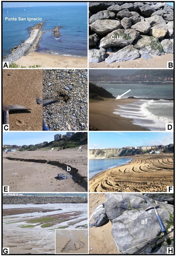
26            OSTENDE AND ARRIGUNAGA BEACHES, TWO DIFFERENT INTERVENTIONS IN NORTHERN SPAIN

               de los numerosos temporales marítimos sufridos. Como novedad, se constata la rápida
               formación de acuafactos como nuevas estructuras geomorfológicas sobre las protusiones
               rocosas por la abrasión mecánica de agua/arena-gravilla. Por último, surge la pregunta
               sobre si este tipo de intervención resulta adecuado en el actual contexto de conservación
               ambiental.

               Palabras clave: dinámica costera, regeneración de playas, escorias alto horno, beachrock,
               acuafactos, costa Vasco-Cantábrica.

               Elorza, J., 2021. Ostende and Arrigunaga beaches, two different interventions and subsequent
               geomorphological changes in northern Spain: An appropriate policy to follow? Revista de la
               Sociedad Geológica de España, 34 (1): 25-35.

Introduction

    The last third of the 20th cen-
tury saw a certain economic boom
in Basque society, which allowed
the most fortunate to acquire a se-
cond residence in small coastal
towns along the Basque-Cantabrian
coast (Bizkaia, Cantabria) (Fig. 1A).
This led to a major increase in po-
pulation in these small towns during
the summer period, with the conse-
quent demand for public assistance
services and recreational spaces. In
this sense, according to 2019 data,
the municipality of Castro Urdiales
(Cantabria) went from a stable cen-
sus population of 32,069 inhabitants
to more than 70,000 inhabitants du-
ring the summer season, whereas in
the municipality of Getxo (Bizkaia)
the population surveyed in 2019 rea-
ched 79,946 inhabitants.
    One of the most frequently re-
quested services during the summer
season was for new beaches to be
developed as recreation areas, for-
cing the responsible administra-
tions (municipal, provincial, and
the Coastal Demarcation Office) to
coordinate and undertake specific
projects to satisfy the growing de-
mand. In 1991, the municipality of
Castro Urdiales undertake a work
on the Urdiales cove, initially wi-
thout sand and with a small marsh
area, that was to become the so-ca- Fig. 1.- A: Geographical location of the Ostende artificial beach (Castro Urdiales, Cantabria)
lled artificial beach of Ostende and the Arrigunaga beach (Getxo, Bizkaia) along the Basque-Cantabrian coast. *(b) Location
(around 750 m in length, Fig. 1B). of the Abra-Ciervana buoy. B: View from the northern part of the current Ostende artificial
                                         beach (750 m in length), showing the tracks from the mechanical levelling that is carried out
In the municipality of Getxo, by
                                         daily. C: General view of the current Arrigunaga beach from its western part (630 m in length).
contrast, the work was undertaken
on the Arrigunaga urban beach (around 630 m in length, the area, with the construction of three groynes and a lar-
Fig. 1C) that due to its deep anthropic footprint was prac- ge breakwater (associated with Punta San Ignacio). It was
tically in disuse and was not recommended for bathing. completed in 1999 with the addition of bioclastic natural
This situation was mended by a complex intervention in sand to the beach.

      Revista de la Sociedad Geológica de España, 34 (1), 2021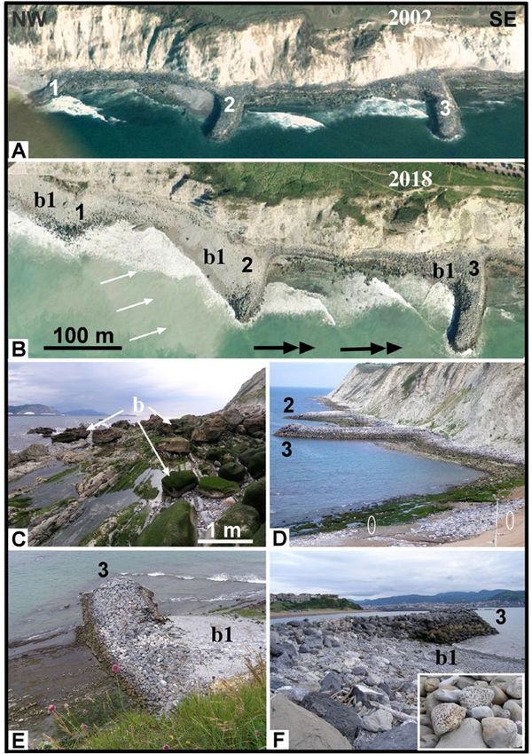
J. Elorza                                                              27

    More than two decades after these interventions (30                  rocky protrusions and in the breakwater blocks that stand
and 21 years, respectively), it seems appropriate to review              out in the foreshore.
how the processes of coastal dynamics have acted upon
them. In this sense, this study aims to inquire whether the              Geological context            and     characteristics      of    the
behaviour has been as theoretically predicted or whether                 interventions
there have been substantial changes in the profiles of each
beach. The loss and/or migration of the sands concentra-                 Ostende beach (Urdiales Cove)
ted in certain areas may have modified the expected beach
half-life. As regards the groynes and the breakwater built                   The Ostende artificial beach (43º 23’ 21” N and 3º
on Arrigunaga beach, the question is whether they have                   13’ 33” W, Fig. 1A) belongs to the municipality of Cas-
been effective or been overcome by the coastal dynamics.                 tro Urdiales (Cantabria). From a geological point of view,
Additionally, this study also deals with how the interaction             the beach substrate is composed of limestones from the
of tides and sediments has promoted an abrasive process                  so-called “Planar-parallel limestone of the Urdiales Cove
producing new geomorphological structures in the natural                 Formation” (Rosales, 1995, 1999). Dated to the lower Al-
                                                                                               bian, it is composed of 200 m-thick
                                                                                               rhythmic alternations of marls,
                                                                                               marly limestones and limestones
                                                                                               in decimetre-thick beds. Rosales
                                                                                               (1995) suggested that this formation
                                                                                               belongs to a hemipelagic platform
                                                                                               related to the distal part of a carbo-
                                                                                               nate ramp-type shelf. Westwards the
                                                                                               unit grades laterally to shallow shelf
                                                                                               limestones (Oriñon Limestone For-
                                                                                               mation).
                                                                                                   Refurbishment works were ca-
                                                                                               rried out in a short period of time
                                                                                               (from 29/12/1988 to 02/01/1991)
                                                                                               and consisted of the modification of
                                                                                               Urdiales cove by the deposition and
                                                                                               levelling of crushed gravel (6-8 mm
                                                                                               in diameter) along a coastal strip
                                                                                               around 750 m in length, using a to-
                                                                                               tal volume of 330,580 m3 to this end
                                                                                               (data provided by the Cantabrian
                                                                                               Coastal Demarcation Office) (Figs.
                                                                                               1B, 2A-C). Currently, the sediments
                                                                                               found on the artificial beach corres-
                                                                                               pond to two types: a) a minor part
                                                                                               of fine-medium bioclastic natural
                                                                                               sands (0.2-0.3 mm) typical of the
                                                                                               beaches of the Cantabrian coast; and
                                                                                               b) a majority of limestone gravels
                                                                                               (6-8 mm) that corresponds to the
                                                                                               artificial crushed deposit, extracted
                                                                                               from the Santullán quarry, current-
                                                                                               ly showing a clear increase in the
                                                                                               roundness index (Figs. 2D-F).

                                                                                                    Arrigunaga beach

                                                                                                        Three sectors bounded by faults
                                                                                                    can be distinguished in the cliffs
Fig. 2.- Ostende beach, Castro Urdiales. A: Aerial view of Urdiales cove, dating from 1965.
                                                                                                    bordering the Arrigunaga beach
B: Aerial image similar to the previous one, taken in 2015, with evidence of the sand-gravel
spill creating the recreation area (750 m in length). C: Current picture of the artificial beach
                                                                                                    (43º 21’ 22.0” N and 3º 01’ 10.00”
from the southeast, where the protrusions of Urgonian limestone can be observed. D: Detail          W, Fig. 1A), Getxo (Bizkaia) (Ro-
of the fine bioclastic sands that make up a small part of the sandbank. E-F: Appearance of          dríguez-Lázaro et al., 1989). The
the artificial angular gravels (E), now notably rounded (F) by the abrasive effect exerted over     northeastern sector comprises tur-
three decades. Marker and coin are 2 cm and 2.2 cm in diameter, respectively.                       bidite sediments that belong to the

                                                                               Revista de la Sociedad Geológica de España, 34 (1), 2021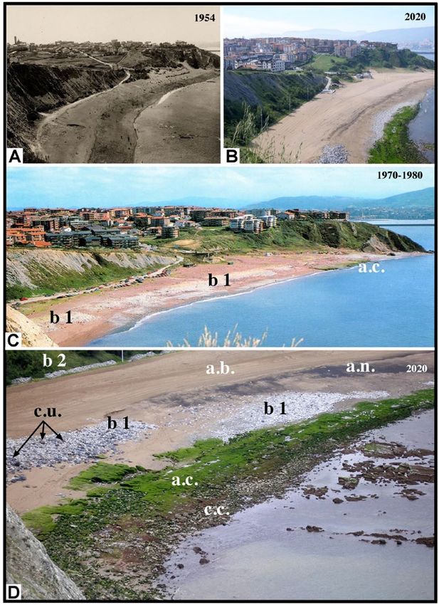
28           OSTENDE AND ARRIGUNAGA BEACHES, TWO DIFFERENT INTERVENTIONS IN NORTHERN SPAIN

middle Eocene and consist of an alternation of calcarenites a family beach with limited use, little recommended for
and coarse calcisiltites with marls. The central sector, in bathing owing to the polluted waters from its confluence
mechanical contact (thrust sheet) with the former sedi- with the still untreated freshwaters of the Nervión River
ments of lower-middle Maastrichtian age crop out, being (Figs. 1A, 3A). Notably, most of the industries located on
predominantly composed of marls and marly limestones the estuary dumped their waste into this river without prior
without calcarenitic beds. The macro-palaeontological treatment. Coastal drift, wave currents and storm waves led
content includes ichnofossils, internal moulds of inocera- to the accumulation of part of this industrial discharge in
mids and ammonoid impressions. These materials form a the eastern area of the Nervión river mouth, specifically on
small synclinal structure in mechanical contact to the west Arrigunaga, Azkorri and Barinatxe beaches, in addition to
with sediments from the middle Eo-
cene to the lower Eocene. The out-
crops at the centre of the cliff are
mostly marls, except at some points
where turbidite beds with nummu-
litid fossils occur. Further west, the
Algorta-Azkorri sandstones crop
out significantly; these rocks are
quartz-feldspathic turbidites (Payros
et al., 2006, 2009). Ostracod asso-
ciations indicating increasingly
deep marine depositional environ-
ments from the Maastrichtian to the
middle Eocene (Rodríguez-Lázaro
et al., 1989).
     The Arrigunaga beach can be
classified morphodynamically as re-
flective to intermediate depending
on the season of the year, as well as
corresponding to the approximately
marginal beach type (Gutiérrez Elor-
za, 2008), within the Abra Bay (Fig.
1A). This beach has gone through di-
fferent phases of use throughout the
20th century. As a place name in Bas-
que, “Arrigunaga” denotes a place of
stones (“arrigun-aga”) (Goikoetxea
Araluce, 1984), as it is graphically
reflected in a nautical chart entitled
“Plano de la Barra de Bilbao (1806)”
(Martin-Merás and Rivera, 1990),
which reveals that the present-day
Arrigunaga beach consisted of cob-
bles-boulders. This situation changed
when a major accumulation of coarse
sand, granules, pebbles and cobbles
(1 mm-120 mm in diameter) was
deposited on the beach. These new
sediments, which were poorly sorted,
came from industrial waste (mainly Fig. 3.- Arrigunaga beach, Getxo. A: General view of the beach from around 1954. B:
slag from an iron blast furnace) and Current picture with an orientation similar to the previous one (630 m in length). C: Image
were discharged onto the coastal pla- from about 1970-1980, where turbidite blocks (b1) and cemented sands (a.c.) are present
tform by the blast furnace company as a beachrock. Note the general reddish colour of the sands. D: Detail of the current beach
“Altos Hornos de Vizcaya” between where boulders (c.c.) and cemented sands (a.c.) from the discharge of slag into the sea by the
1902 and 1966, with a calculated vo- iron blast furnace (Altos Hornos de Vizcaya) can be seen at low tide. The bioclastic sands
                                         (a.b.) collected by dredging are mixed with a fine metallic mineral component detached
lume of about 25 million tons (Aizpi-
                                         from the blast furnace slag, producing the blackened appearance of the sands (a.n.). The
ri, 1983; Astibia, 2012; Pujalte et al., natural accumulation of turbidite blocks (b1) is evident; these come from the cliff along
2015).                                   with other blocks of Urgonian limestone (c.u.) eroded from the groynes. Recently, some
      In a first phase, between the of these boulders (b2) have been mechanically transported and accumulated at the contact
years 1940-1960, Arrigunaga was between the high backshore and the cliff.

      Revista de la Sociedad Geológica de España, 34 (1), 2021
J. Elorza                                                              29

other cliff areas such as Tunelboka (Fig. 1A). Its rapid, in    now providing a 630 m-long beach suitable for swimming,
situ, cementation caused the formation of large, sub-hori-      with a surface area greater than 51,000 m2 at low tide and
zontal sediment beds that reached variable thicknesses of       35,000 m2 at high tide (data obtained from Bizkaia Provin-
3-9 m with parallel and cross stratifications with a slight     cial Council). Arrigunaga beach has been frequently used
inclination towards the sea (García-Garmilla, 1990). Aerial     since its establishment until the present day, although it has
photos from 1956-57 (http://centrodedescargas.cnig.es/          undergone modifications that will be further commented
CentroDescargas/index.jsp#) show the presence of these          below (Figs. 3B, D).
cemented beds at their maximum development. They are
regarded as a beachrock formed on temperate shorelines,         Effects of the deposits and new geoforms
where the basal part is mostly conglomeratic, meanwhile
very coarse sandstones dominate the upper part. Their de-       Ostende artificial beach, 30 years later
trital components of anthropogenic origin are considered
as human ichnofossils of the so called Anthropocene time            The most notable geomorphological changes that can
period (Astibia, 2012). Subsequent works have analysed          be observed in the Ostende beach are the following.
their benthic foraminiferal associations (Martínez García           (a) It can be currently considered as a pocket beach
et al., 2013), their geomorphological evolution (Pujalte et     (Davies, 1980) limited by headlands of compact Urgonian
al., 2015) and their geochemical composition (Arrieta et        limestones, where theoretically the volume of sediment re-
al., 2011; Iturregui et al., 2014; Arrieta et al., 2017).
                                                                mains constant. The beach has maintained itself, despite
     A second phase began between the years 1972-75 with
                                                                not receiving new contributions of natural, bioclastic or
the construction of the Punta Lucero dyke-dock (2,750 m
                                                                river sands from longshore drift currents. However, the
long) and the unfinished Punta Galea dyke (projected len-
                                                                action of the tides (mesotidal, i.e., 2-5 m) and storm wa-
gth of 3,400 m; 250 m completed), which modified the
usual coastal current regime and led to an intense erosive
activity that dismantled the beachrock in the most heavily                     Abra-Ciervana buoy (2001-2020)
eroded areas. This erosive activity, together with the cessa-          Months      Hmax. Tp. Dir. Year Day Hour
tion of industrial discharges in 1966, is confirmed by aerial          January      11.9    9.1 346 2003 31    6
orthophotos dating from 1983 onwards. Nevertheless, the                February      9.5   10.0 340 2005 14    0
Arrigunaga beach continued to deteriorate, and was not                  March        9.3   16.6 333 2008 11    2
recommended for swimming and/or sunbathing (Fig. 3C).                    April       7.1   14.3 334 2012 18   18
     The third phase corresponds to its regeneration. This               May         6.7   13.3 336 2004 5    11
phase began in 1995, when an attempt to control the lands-               June        4.9   8.00 348 2010 16   15
lides off the Punta Galea cliff was made by building a ba-               July        5.0   10.1 334 2001 18   19
                                                                        August       5.0   10.0 338 2007 21    6
rrier of three groynes to prevent the migration of blocks
                                                                      September      6.1   13.4 330 2017 12    0
and gravel towards the beach (Losada and Medina, 1993).
                                                                       October       6.3    8.7 356 2012 27   20
These groynes were built with large limestone blocks
                                                                      November       8.4   11.1 333 2009 8    11
(Urgonian facies, Aptian-Albian), being the closest to the            December       8.8   14.3 334 2007 10    2
beach the longest one (80 m long), followed 200 m away                Hmax: Maximum Wave Height (meters)
by another groyne (60 m long), and finishing 190 m away               Tp: Peak Period (seconds)
with the shortest one (50 m long). Due to their location,             Dir: Peak Direction, "coming from"(degrees)
these groynes are faced to the usual northwesterly stor-                       Abra-Ciervana buoy (2001-2020)
ms from the sea that directly impacting on them. The data              Months Hs Max. Tp. Dir. Year Day Hour
collected by the Abra-Ciervana buoy installed very close               January      5.5    12.5 333 2005 18   21
to the cliff (Fig. 1A) provide the average values of maxi-             February     5.4    14.3 336 2013 6    21
mum wave height, significant wave height, peak period                   March       6.7    16.6 333 2008 11    2
and average peak direction on a monthly basis during the                 April      4.8    14.3 334 2012 18   18
time series from 2001 to 2020 (Table 1; data obtained at                 May        4.7    12.5 333 2004 5    10
Puertos del Estado; www.puertos.es/en-us/oceanografia/                   June       2.7    8.00 346 2010 16   18
Pages/portus.aspx).                                                      July       3.0    11.1 331 2001 18   17
     It was from 1998 that the recovery project of the beach            August      3.1     9.1 342 2007 21    7
itself was undertaken, with the removal of the cemented               September     3.5    11.7 333 2017 11   22
cast slag blocks (16,000 m3) and their replacement by bio-             October      3.5     9.5 335 2003 23   15
                                                                      November      5.1    14.3 331 2010 9     9
clastic sands (213,000 m3) composed of bivalve remains,
                                                                      December      6.0    16.6 342 2007 10    1
echinoderms, calcareous algae, and fragments of quartz
                                                                      Hs: Significant Wave Height (meters)
and feldspars, from a sandbar near the small town of Bakio            Tp: Peak Period (seconds)
(43º 26’ 40.18” N; 2º 48’ 37” W). These sands were extrac-            Dir: Peak Direction, "coming from" (degrees)
ted at a depth of more than 20 m by means of several suc-       Table 1.- Monthly mean values of maximum wave height,
tion dredgers (Iria Flavia and Atlántida Primera dredgers).     significant wave height, peak period, and average peak direction
The intervention was completed with the urbanization of         during the period 2001-2020, at the Abra-Ciervena buoy (Puertos
the beach and the creation of the corresponding accesses,       del Estado).

                                                                      Revista de la Sociedad Geológica de España, 34 (1), 2021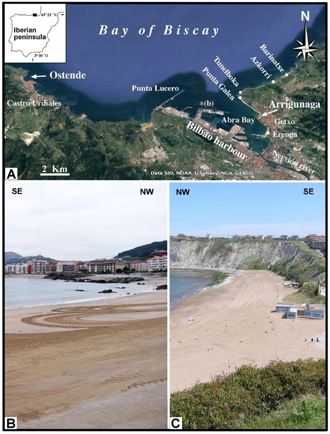
30            OSTENDE AND ARRIGUNAGA BEACHES, TWO DIFFERENT INTERVENTIONS IN NORTHERN SPAIN

                                                                      phologies and wide grooves are characteristic, as well as
                                                                      bows perpendicular to the direction of the waves (Figs. 4B,
                                                                      5A-B).
                                                                          (e) Taken into account the time elapsed, analysis of the-
                                                                      se geoforms makes it possible to establish the approxima-
                                                                      te speed of reduction undergone by the protrusions due to
                                                                      mechanical abrasion. Our estimation was that the alveoli
                                                                      initially formed by echinoderms, calcareous algae activity
                                                                      (Fig. 5A) have been lowered by 1-2 cm, so the abrasion
                                                                      rate may be between 0.3-0.6 mm/year (Elorza and Higue-
                                                                      ra-Ruiz, 2016).

                                                                      Regenerated Arrigunaga beach, 20 years later

                                                                          The most relevant geomorphological modifications at
                                                                      the Arrigunaga beach are as follows.
                                                                          (a) In the eastern part of the beach, a marked loss of
                                                                      the bioclastic sand provided during the intervention carried
                                                                      out in 1999 and an accumulation of boulder blocks (0.5-1
                                                                      m3) from different sources occurred. The turbidite blocks
                                                                      (b1) of light grey tones coming from the cliff are associa-
                                                                      ted with the notable presence of blocks of darker tones of
                                                                      Urgonian limestone (c.u.), originally from the partially dis-
                                                                      mantled groynes (Figs. 3 B-D).

Fig. 4.- Ostende beach, Castro Urdiales. A: Low tide view, with the
formation of return channels or rill marks. B: Outcrop belonging
to the “Planar-parallel limestone of the Urdiales Cove Formation”
(lower Albian), affected by water/sand-gravel abrasion, which
originates marine aquafacts (af). The marker is 13 cm in length.

ves causes a significant accumulation of gravel-sand in the
high backshore, with a variable steep slope depending on
the area (> 10º) as far as the foreshore. Thus, it can be con-
sidered as a reflective-type beach, although it may become
intermediate-type at quiet times, depending on the season
(Figs. 2B-C). Continuous levelling out with machinery
makes the slope reduced, and small return channels or rill
marks start to develop when water pouring from the water
table at low tide conditions (Fig. 4A).
     (b) By contrast with the much finer bioclastic sands
(Fig. 2D), the higher index of roundness (rounded/we-
ll-rounded) and low sphericity of the angular gravels, ar-
tificially dumped on the cove, compared to the original
deposits are particularly noteworthy (Figs. 2E-F).
     (c) After 30 years, the permanence of the beach is en-
sured, if considering that the average life of a regenerated
beach is measured by the time that elapses from the in-
tervention to the loss of at least 50% of the volume of the
beach (Leonard et al., 1990).
     (d) The current morphology of the beach preserves a              Fig. 5.- Ostende beach, Castro Urdiales. A: View of a black
                                                                      limestone protrusion intensely affected by basal abrasion,
significant number of limestone (Urgonian facies) protru-
                                                                      showing a strong polish and wet luster, already above small
sions in the foreshore zone, which favours the generation             alveoli formed by bioerosion (echinoderms, calcareous algae,
of new geoforms considered marine aquafacts (af), already             limpets, sea acorns). B: Detail of wide grooves and fine keels
mentioned by Elorza and Higuera-Ruiz (2016). Strongly                 morphologies characteristic of aquafacts. Hammer and marker
polished surfaces with vertical zoning and fine keel mor-             are 28 cm and 13 cm in length, respectively.

      Revista de la Sociedad Geológica de España, 34 (1), 2021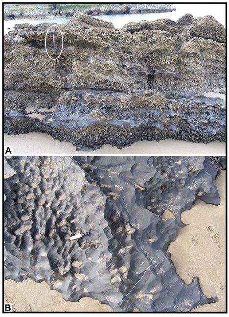
J. Elorza                                                              31

    (b) The three groynes (1, 2 and 3) built in the eastern with a trend to accumulate in the upper backshore zone,
zone in 1995 were affected by waves impact in a few years covering the entire urbanized area showing a steep, but va-
(Fig. 6A), and since 2018 the aerial photographic eviden- riable slope depending on the section (≈ 20º, 3 m high, 75
ce of their destruction is conclusive. Furthermore, in the m long) as far as the foreshore. Daily mechanical levelling
distal groyne 1 an erosive action (flanking effect) in the (Fig. 7F) mitigates the steep slope produced by tides and
leeward area is a recognizable case of “terminal groyne sy- storms. As a result of sand movements, blackened sandy
ndrome” (Valsamidis and Reeve, 2020), which reaches the areas appear occasionally due to the mixing of bioclastic
beach itself (Figs. 6B, D). Currently,
the presence of large immobile tur-
bidite blocks (b), is noticeable over
the abrasion platform (Fig. 6C). The
longest, terminal groyne of 80 me-
tres (groyne 3) has kept in good con-
dition, whereas the smallest (groyne
1) of 50 m is practically dismantled.
The intermediate groyne (groyne
2) is being overcome in the wind-
ward zone by an accumulation of
boulder blocks (b1) from the nearby
cliff (Figs. 6B, D-F, 7A-B). The ac-
cumulation of turbidite blocks (b1)
of considerable sizes (50-100 cm
by 20-40 cm) is notable in groynes
2 and 3; these were colonized long
time ago by lithophagous bivalves,
mainly Lithophaga lithophaga (Fig.
6F). Lithophagous bivalves are
long-lived and can reach ages of up
to 50 years (Peharda et al., 2015), so
continued stability is required in the
shoreface. This suggests that there
has been a reactivation of the near-
shore currents energy since 1975,
favoured by the storms that moved
these blocks from the quiet shorefa-
ce zone, fostering the colonization
and development of the bivalves,
towards the foreshore and backshore
zones. Finally, just in this final area
of the cliff-beach, in relation with a
regional major fault (Rodríguez-Lá-
zaro et al., 1989), continuous loose-
ning of sharp-edged blocks (b) oc-
curs from the cliff (Fig. 7C).
     (c) The loss of sand also reveals
the presence of sub-horizontal bea-
chrock slag beds, which were not
removed during the intervention Fig. 6.- Arrigunaga beach, Getxo. A: Aerial view of the Punta Galea cliff in 2002, with
and are now colonized by green al- the three groynes (1, 2 and 3) built in 1995, slightly affected on their windward sides by
gal mats. The beds mainly consist of the impact of the tidal and storm waves. B: Approximately the same aerial view obtained
slag from the iron blast furnace, and in 2018. Fallen down blocks from the cliff (b1), are destroying groynes 1 and 2, filling
carbonate turbidite blocks, but they the inter-groyne areas, mainly in the leeward zones. Groyne 3 is the least affected groyne,
never contain blocks of the Urgo- although the intense erosion of the cliff is visible in its leeward area. White arrows mark
nian limestone used in the 1995 in- the usual NW direction of the waves. Black arrows indicate the longshore drift current
                                         along the beach. C: Accumulation of large, recently eroded, angular turbidite blocks (b) on
tervention. The beacrock unconfor- the abrasion platform. D: Lateral view of groynes 2 and 3 and the eastern part of the beach
mably overlie the marine abrasion at low tide. White ellipses show human beings for scale. E: View of groyne 3, showing
platform (Figs. 3D, 7D-F).               the windward accumulation of rounded turbidite blocks (b1) and how they bypass the
    (d) Sandy sediments stay in the highest part of the groyne. F: Detail of the windward area of groyne 3 with blocks partially
central area of the beach, although covering the groyne, with an inset of the boulders with lithophagous bivalves.

                                                                         Revista de la Sociedad Geológica de España, 34 (1), 2021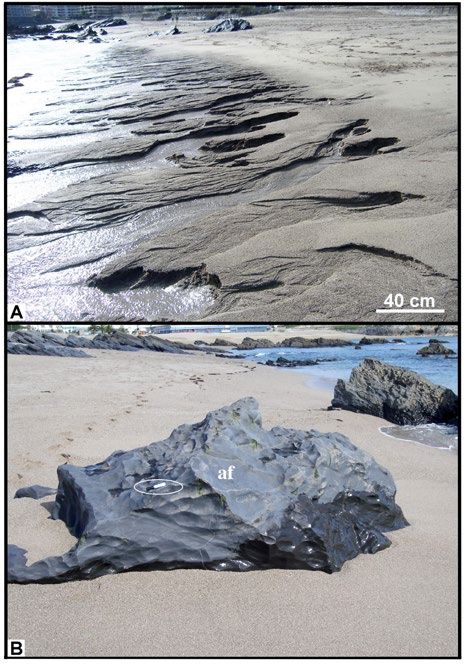
32 OSTENDE AND ARRIGUNAGA BEACHES, TWO DIFFERENT INTERVENTIONS IN NORTHERN SPAIN
sand with fine remains of dark minerals segregated from paration (Fig. 7H). This latter mineral is characteristic of
the slag (Figs. 3D, 7G-H). The composition of these sands, high temperatures (> 570 ºC) in a reducing environment
determined by DRX analysis, corresponds to quartz (SiO2), of anthropogenic slag, meteorites and basalts (Cornell and
calcite (CaCO3), magnetite (Fe3O4), goethite (FeOOH) and Schwertmann, 2003; Gil et al., 2008).
haematite (Fe2O3). Opaque ores such as magnetite, hae- (e) In the western zone, the breakwater (210 m) built
matite and wüstite (FeO) can be observed by magnetic se- perpendicular to the beach line and associated with the
thick-bedded turbidite cliffs of the
Algorta-Azkorri sandstones main-
tains the large blocks of Urgonian
limestone (c.u.) stable, without pro-
ducing any modification in its struc-
ture (Figs. 8A-B).
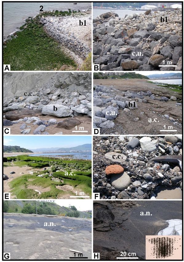
(f) The sediment in the foreshore
zone of the western area ranges from
sand to gravel (Fig. 8C), whereas in
the backshore zone the accumula-
tion of sand is more noticeable (>
3-4 m), almost totally covering the
existing protrusions of siliciclastic
turbidite sandstones (Algorta-Azko-
rri sandstones) (Fig. 8D). There are
ascending-dune deposits (climbing
dunes) of finer grain-size sands (0.1-
0.2 mm), which adapt to the rocky
slope of the cliff (Fig. 8E). The slope
increasing in the shoreface zone (>
10º) is daily mechanically levelled
(Fig. 8F) and it is noteworthy the
presence at low tide of small return
channels due to the outflow from the
water table at the contact with the
abrasion platform (Fig. 8G).
(g) As stable morphological
structures, the incipient polishing
of the initially irregular and rough
surface is detected in some blocks
of the breakwater. This polishing
leads to the consequent formation
of aquafacts (af), despite the fact
that their orientation does not offer
favourable conditions for intense
abrasion (Figs. 8H).
Suggested measures as conclusions
On the Ostende beach, more
Fig. 7.- Arrigunaga beach, Getxo. A: View of groyne 2, with a large number of turbidite intense levelling activity seems ne-
blocks (b1) from the cliff that goes beyond the groyne. On the leeward side, the large number cessary to mitigate the steep slopes
of blocks covered with green algal mats is indicative of their lack of movement as they are (> 10º) that are established between
protected from the waves impact. B: Detail of the leeward area with small, light colour, the shoreface zone and the high bac-
rounded turbidite blocks (b1) over the large, darker, blocks of Urgonian limestone (c.u.). kshore zone. Taking into account
Trunk remains are also deposited. C: Marly limestone blocks (b), eroded from the cliff; the the established half-life values for
lack of resistant turbidite beds causes them to decompose easily over time. D: Blocks of a standard beach, the permanence
turbidite beds, already rounded (b1), from the cliff mixed with blocks of darker Urgonian
of this sandy-gravel artificial beach
limestone (c.u.) detached from the groyne. These loose blocks overlay the cemented sands
(a.c.) from the blast furnace slag. E: General appearance at low tide of the cemented sands
is assured for a long period of time.
(a.c.), now colonized by green algal mats. F: Rounded cemented blocks (c.c.) such as bricks, The continuous and rapid abrasion
slag and limestones. G: View of the bioclastic sands mixed with metallic particles, eroded of the gravel will produce greater
from the slag, producing an overall dark effect (a.n.). H: Detail of the black sands (a.n.) of roundness and a decrease in its gra-
metallic composition (magnetite, haematite and wüstite) with magnetic properties. in-size, improving the recreational
Revista de la Sociedad Geológica de España, 34 (1), 2021J. Elorza 33
quality of the beach. In our opinion, the intervention ca- ter in response to water/sand-gravel abrasion during storms
rried out in 1990 has maintained itself and meets the social (Fig. 8H). This complex intervention seems to have been
and recreational objectives for which it was conceived. successful for the purposes originally pursued as recreation
The Arrigunaga beach poses a more complex problem areas recommended for bathing, but a continuous mainte-
due to the continued contribution of the Punta Galea cliff nance is required to avoid the dismantling of the groynes.
blocks to the northeastern part of the beach. If the inten- Once the evolution of these two beaches is known, the
tion is to maintain the entire useful surface of the beach as question is whether this type of regeneration is appropriate
a recreational area, the question is
whether it is advisable to remove
the still-existing cemented conglo-
merate-sand bed fragments (bea-
chrock), given their very high he-
ritage value as a geological witness
of the Industrial Revolution in nor-
thern Spain (Astibia, 2012). The
large, well-rounded blocks that ac-
cumulate in the eastern zone can be
redistributed in the upper backsho-
re zone (b2), a task already started
in 2020 (Fig. 3D). The progressive
erosion of groynes 1 and 2, indica-
tive of the impact of storm waves
and the high block accumulation
from nearby cliffs, suggests the
need to reinforce and periodically
maintain these groynes, evaluating
the possible incorporation of larger
blocks among the current ones. For
these future maintenance interven-
tions, the monthly mean values of
the maximum wave height (5-12
m), the peak period (9-16 seconds)
and the peak direction “coming
from” (330-356 degrees) provi-
ded by the Abra-Ciervana buoy
during the years 2001-2020 (Table
1), may help to design the most
appropriate action. Also, an upda-
ted study of the coastal currents is
required to adjust the spacing and
length of the groynes in order to
avoid the flanking effect. The pre-
sence of turbidite blocks colonized
by lithophagous bivalves, mostly
Lithophaga lithophaga, confirms
the idea that marine currents have
been reactivated and have changed
in direction since 1975. Regarding
sand movements, it seems that the Fig. 8.- Arrigunaga beach, Getxo. A: View of the Punta de San Ignacio breakwater associated
mechanical levelling that is carried with large turbidite beds, in the western part of the beach. B: View of the large Urgonian
out on a daily basis is not enough limestone breakwater blocks (c.u.), preserved since they were built, without further modification
to maintain the beach profile (Fig. by storms. C: Bioclastic sand added to the beach in 1999 and round-edged gravel from the
8F). The continuous levelling of natural cliff. D: Northwestern storm waves generate cup shapes on the beach; the white arrow
the profiles in the central and wes- points to partially covered protrusions. E: View of a small berm (b) after a spring tide, the
climbing dunes are visible in the distance, marked by the white arrows. F: Daily mechanical
tern zones is a weak response to levelling mitigates the steep slope of the beach. G: Southwestern foreshore zone with the
the natural movements of the sand, presence of an erosion surface made up of thin folded beds from the lower Eocene sediments.
with slopes between 10-15º. There Inset shows a detail of return channels or rill marks. H: Urgonian limestone breakwater blocks
is an incipient formation of aqua- showing the onset of aquafacts (af) formation due to abrasion by sand-loaded waves. The luster
facts in the blocks of the breakwa- and smooth polishing surface is characteristic. The hammer for scale is 32 cm in length.
Revista de la Sociedad Geológica de España, 34 (1), 202134 OSTENDE AND ARRIGUNAGA BEACHES, TWO DIFFERENT INTERVENTIONS IN NORTHERN SPAIN
on the Basque-Cantabrian coast, where the need for beach Arrieta, N., Iturregui, A., Martínez-Arkarazo, I., Murelaga, X.,
areas is still high, particularly in the vicinity of large urban Baceta, J.I., de Diego, A., Olazabal, M.A., Madariaga, J.M.,
cities (Pilkey and Cooper, 2014). It is beyond the scope of 2017. Characterization of ferruginous cements related with
weathering of slag in a temperate anthropogenic beachrock.
the present work to give a conclusive answer that allows
Science of The Total Environment, 581-582: 49-65.
the most suitable policy to be decided upon both cases
Astibia, H., 2012. Tunelboka y Gorrondatxe (Getxo, Bizkaia), fó-
(MOPU, 1985, 1991; Canteras et al., 1995; París Solas et siles humanos para el Antropoceno. In: Euskonews 640, 1–11.
al., 1995). However, with a full knowledge of the environ- http://www.euskonews.com/0640zbk/gaia64002es.html [Con-
mental impacts that may occur (Finkl and Walker, 2005), sultado 3/05/2021].
these actions may be acceptable if all the requirements Canteras, J.C., Pérez, L., Cantera, E., Soler, M., Carralimos, C.I.,
stipulated both in the European Legislation (85/377/EEC) 1995. Impacto ambiental de regeneración de playas: La Playa
and at a national level (Royal Legislative Decree 1302/86, de Poniente (Gijón). Ingeniería del Agua, 2 (Num. Extraor-
evaluation of environmental impact; Royal Decree dinario): 223-243.
Cornell, R.M., Schwertmann, U., 2003. The iron oxides: struc-
1131/88, regulation for the execution of Royal Legislative
ture, properties, reactions, occurrences and uses. John Wiley
Decree 1302/86) are fulfilled. In addition, the currently in and Sons, 188p.
force new Spanish Coastal Law (i.e., “Ley 2/2013, de 29 Davies, J.L., 1980. Geographical Variation in Coastal Develop-
de mayo, de protección y uso sostenible del litoral y de mo- ment. Longman, London, 212 p.
dificación de la Ley 22/1988, de 28 de Julio, de Costas”), Elorza, J., Higuera-Ruiz, R., 2016. Abrasión mecánica
published in May 2013, involves the first major change in (ventifactos, acuafactos) sobre calizas-dolomías urgonianas
the last 25 years since the previous 1988 Spanish Coastal de la costa oriental cántabra: Precisiones sobre su edad.
Law (Negro et al., 2014). Revista de la Sociedad Geológica de España, 29 (2): 3-22.
Finkl, C.W., Walker, H.J., 2005. Beach Nourisment. In: Enci-
The most obvious benefits may be to reduce the high
clopedia of Coastal Science, (M.L. Schwartz, Ed). Springer,
occupation of traditional beaches as well as to have well
Dordrecht, 147-161.
known spaces for their recent interventions. These places García-Garmilla, F., 1990. Diagénesis de las arenitas: ejemplos
function as open laboratories where it is possible to com- del Cretácico, Terciario y Cuaternario de la zona de Bilbao.
pare the response of coastal dynamics in the face of the Kobie (Serie Ciencias Naturales), Diputación Foral de Viz-
climate change that is already threatening the coastal and caya, 19: 85-103.
populated areas. Gil, P.P., Yusta, I., Orue-Etxebarria, X., Herrero, J.M., Baceta,
J.I., Artaraz, J., Madina, E., Mintegui, J.M., 2008. Caracter-
Acknowledgements and funding ización Mineralógica y Química de Escorias de Ferrerías de
Monte (“haizeolas”) en el Entorno de Galdakao (Vizcaya).
Macla, 9: 117-118.
The present study has been funded by the Universidad Goikoetexea Araluce, N., 1984. Toponimia Euskara. Kobie (Serie
del País Vasco/Euskal Herriko Unibertsitatea (UPV/EHU, Etnografía). Diputación Foral de Vizcaya, l: 79-141.
research group GIU18/16317/05) and by the Elorza Foun- Gutiérrez Elorza, M., 2008. Geomorfología. Pearson Prentice
dation. The paper greatly benefited from constructive re- Hall, Madrid, 920 p.
views of J. García-Hidalgo (Universidad de Alcalá) and an Iturregui, A., Arrieta, N., Baceta, J.I., Murelaga, X., Olazabal, M.A.,
anonymous referee and the journal editor N. López-Gon- Martínez-Arkarazo, I., Madariaga, J.M., 2014. The relevance of
zález for their critical and constructive comments which the analytical methodology in the geochemical study of beachrock
greatly improved the final manuscript. We sincerely appre- outcrops: Arrigunaga beach inside the Nerbioi-Ibaizabal estuary
(Getxo, Basque Country). Analytical Methods, 6 (20): 8247-8257.
ciate the information provided by A.H. Molpeceres Atucha
Leonard, L.A., Clayton, T., Pilkey, D.H., 1990. An analysis of
of the Department of Sustainability and the Natural En- beach design parameters on US east coast barrier islands.
vironment (Bizkaia Provincial Council). We acknowledge Journal of Coastal Research, 6: 15-36.
M.C. Galván (Archive of the Castro Urdiales Town Hall) Losada, M.A., Medina R., 1993. Estudio de la playa de Arrigu-
and J.L. Tejerina (Cantabrian Coastal Demarcation Office) naga. Situación actual y alternativas de regeneración. Fun-
for the information provided on the Ensenada de Urdia- dación Torres Quevedo. Universidad de Cantabria, 72 p.
les-Playa de Ostende. To José Fernández from “Canteras Martín-Merás, L., Rivera, B., 1990. Catálogo de cartografía
de Santullán”. To A. Uriarte (AZTI) and A. Franco (EVE) histórica de España del Museo Naval. Museo Naval-
Ministerio de Defensa. Madrid, 435 p.
for the general information. We are also grateful to Rupert
Martínez García, B., Pascual, A., Baceta, J.I., Murelaga, X., 2013.
Glasgow for improving the English text. Estudio de los foraminíferos bentónicos del “beach-rock” de
Azkorri (Getxo, Bizkaia). Geogaceta, 53: 29-32.
References MOPU, 1985. Política de costas: plan de actuaciones 1983-1990.
Documentos del Ministerio de Obras Públicas y Urbanismo.
Aizpiri, F., 1983. Cementación por vertidos industriales en playas Servicio de Publicaciones, Secretaría General Técnica, Ma-
de Vizcaya. Universidad del País Vasco/Euskal Herriko drid, 209 p.
Unibertsitatea, unpublished, 35 p. MOPU, 1991. Actuaciones en la costa. Dirección General de
Arrieta, N., Goienaga, N., Martínez-Arkarazo, I., Murelaga, X., Puertos y Costas. Servicio de Publicaciones, Secretaría Gen-
Baceta, J.I., Sarmiento, A., Madariaga, J.M., 2011. Beachrock eral Técnica, Madrid, 307 p.
formation in temperate coastlines: Examples in sand-gravel Negro, V., López-Gutiérrez, J., Esteban, M.D., Matutano, E.C.,
beaches adjacent to the Nerbioi-Ibaizabal Estuary (Bilbao, Bay 2014. An analysis of recent changes in Spanish Coastal Law.
of Biscay, North of Spain). Spectrochimica Acta A, 80: 55-65. Journal of Coastal Research (Special Issue), 70, 448-453.
Revista de la Sociedad Geológica de España, 34 (1), 2021J. Elorza 35
París Solas, C., Wibbelink, H., Basabe Criado, J.M., 1995. Con- cementadas del “Antropoceno” de Bizkaia, País Vasco: ori-
strucción de playas. Experiencias en España. In: Proyectos y gen y degradación. Geogaceta, 57: 123-126.
Construcción de playas artificiales y regeneración de playas. Rodríguez-Lázaro, J., Elorza, J., Orue-Etxebarria, X., Aguirre, J.,
Ingeniería del Agua, 2 (Num. Extraordinario): 167-180. 1989. Materiales de edad maastrichtiense en la serie eocénica
Payros, A., Orue-Etxebarria, X., Pujalte, V., 2006. Covarying sedimen- de flanco-SW del Sinclinorio de Bizkaia (Arrigunaga, N de
tary and biotic fluctuations in Lower-Middle Eocene Pyrenean Bilbao). Kobie, 18: 105-114.
deep-sea deposits: palaeoenvironmental implications. Palaeoge- Rosales, I., 1995. La Plataforma carbonatada de Castro Urdia-
ography, Palaeoclimatology, Palaeoecology, 234: 258-276. les (Aptiense-Albiense, Cantabria). Tesis Doctoral, Univ. del
Payros, A., Orue-Etxebarria, X., Bernaola, G., Apellaniz, E., Di- País Vasco, 496 p.
narès-Turell, J., Tosquella, J., Caballero, F., 2009. Character- Rosales, I., 1999. Controls on carbonate-platform evolution on
ization and astronomically calibrated age of the first occur- active fault blocks: The Lower Cretaceous Castro Urdiales
rence of Turborotalia frondosa in the Gorrondatxe section, a Platform (Aptian-Albian, Northern Spain). Journal of Sedi-
prospective Lutetian GSSP: implications for the Eocene time mentary Research, 69: 447-465.
scale. Lethaia, 42: 255-264. Valsamidis, A., Reeve, D.E., 2020. A new approach to analytical
Peharda, M., Puljas, S., Chauvaud, L., Schöne, B.R., Ezgeta-Bal- modelling of groyne fields. Continental Shelf Research, 211:
ic, D., Thébault, J., 2015. Growth and longevity of Lithopha- 104288.
ga lithophaga: what can we learn from shell structure and sta-
ble isotope composition? Marine Biology, 162: 1531-1540.
Pilkey, O.H., Cooper, J.A.G., 2014. The last beach. Duke Univer- MANUSCRITO RECIBIDO EL: 01-02-2021
sity Press. Durham and London, 211 p. RECIBIDA LA REVISIÓN EL: 19-04-2021
Pujalte, V., Astibia, H., Aizpiri, F., Payros, A., 2015. Las playas ACEPTADO EL MANUSCRITO REVISADO EL: 13-05-2021
Revista de la Sociedad Geológica de España, 34 (1), 2021You can also read