OPEN SPACES IN MANP PARISHES - (January 2021) - STEERING GROUP WORKING DOCUMENTS
←
→
Page content transcription
If your browser does not render page correctly, please read the page content below
OPEN SPACES IN MANP PARISHES

 STEERING GROUP WORKING DOCUMENTS
   (covering, MARL15, MARL16, MARL17, MARL18)

(January 2021)
CONTENTS

1. Open Spaces in MANP Area

2. Open Space Lists (MARL 15, 16, 17 and 18. Also
   connectivity between open spaces)

3. Technical information to support MARL18

4. Needs of Local Sports Organisations

5. Chopping Knife Lane (current open space referred to in the
   draft Site Assessments Report as Further Land off Elcot
   Lane)

(ALL INCLUDED HERE AS SEPARATE DOCUMENTS WITH
            DIFFERENT PAGE NUMBERS)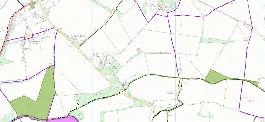
Open Spaces in MANP Area – Regulation 14
MANP Policies 16 and 17 and other valued spaces with existing protection
This document has been produced as part of the Marlborough Area Neighbourhood Plan (MANP) to list:-
Open Green Spaces (to protect from inappropriate development) – MANP Policy 16
Valued Community Open Spaces (to protect from inappropriate development) – MANP Policy 17
Valued Green Spaces with Existing Protection.
Please note that Valued Green Spaces with Existing Protection are already afforded a high level of protection and are therefore not included
in the Marlborough Area Neighbourhood Plan. They are listed below but do not appear on any of the Policy maps.
This document also:-
Updates the Wiltshire Open Spaces and Play Area Study (2014 -2026) by identifying and describing all the present green spaces for
the MANP
Describes Open Spaces in accordance with WC’s Open Spaces Policy
Applies the NPPF Criteria for assessing Local Green Spaces (paragraphs 99 and 100)
National Planning Policy Framework (2019) Guide Lines
Para 99 - The designation of land as Local Green Space through local and neighbourhood plans allows communities to identify and protect green areas of
particular importance to them. Designating land as Local Green Space should be consistent with the local planning of sustainable development and
complement investment in sufficient homes, jobs and other essential services. Local Green Spaces should only be designated when a plan is prepared or
updated and be capable of enduring beyond the end of the plan period.
Para 100 - The Local Green Space designation should only be used where the green space is:
a) In reasonably close proximity to the community it serves;
Susanne Harris 20/01/2021 – Description of Open Spaces in MANP Area – Regulation 14 Page 1
b) Demonstrably special to a local community and holds a particular local significance, for example because of its beauty, historic significance,
recreational value (including as a playing field), tranquillity or richness of its wildlife;
c) Local in character and is not an extensive tract of land.
Using NPPF guidance and additional notes from the Blandford +Neighbourhood Plan Local Green Spaces Study 2019 the following tests have been applied
to all the green spaces identified in the Marlborough Neighbourhood Plan Area. This gives evidence that protection is needed from future development as
they are valued by the local community for promote social interaction, are safe and accessible, enable and support healthy lifestyles and provide social,
recreational and cultural facilities for the community.
National Planning Policy Framework (2019) Guide Lines and Blandford +Neighbourhood Plan Local Green Spaces Study (2019):
Test One
Is the site free of planning permission?
Test 2
Is the site reasonably close to the community it serves?
Test 3
Is the site local in character and not greater than five hectares?
Test 4 (Blandford + study)
Is the site demonstrably special to the local community judged on the following criteria:-
Beauty – This relates to the visual attractiveness and aesthetic value of the site, and its contribution to the streetscape, landscape, character or
setting of a settlement. To qualify, the site should contribute significantly to local character, for example by defining a sense of place, or by helping
to define the physical form of a settlement
Historic significance – This relates to the historic importance a site holds for the local community. This could be because it contributes to the setting
of a heritage asset or some other locally valued landmark. It might be because the site holds cultural associations which are of particular
Susanne Harris 20/01/2021 – Description of Open Spaces in MANP Area – Regulation 14 Page 2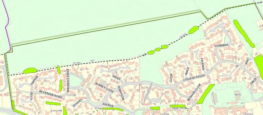
significance to the local community. Where the site is already protected by a designation (e.g. AONB), consideration should be given as to whether
any additional benefit would result from designation as Local Green Space
Recreational value – Sites would need to hold local significance for recreation and be important to the community for a particular recreation activity
or range of activities. These could be formal or informal activities
Tranquillity – In order to qualify, the site would need to be viewed by local people as important for the tranquillity it provided, offering a place for
reflection and peaceful enjoyment
Richness of wildlife – A site would need to be locally significant for wildlife in a way that could be demonstrated. It might, for example, be home to
species or habitats of principal importance, veteran trees, or locally characteristic plants and animals such as mistletoe. (continued)
Where the site is already protected by a designation (e.g. SSSI), consideration should be given as to whether any additional benefit would result from
designation as Local Green Space.
Other reason – Sites might be special and locally significant for reasons other than those identified above. For example, a site might make a particular
contribution to defining the individual character of a settlement, or it might be an asset of community
Key:
Protecting Local Green Spaces Pages 4 to 9
Protecting Valued Community Open Spaces Pages 10 to 16
Valued Spaces with existing protection Page 17
MRA Marlborough Recorded Areas
MM Map Measurement
Susanne Harris 20/01/2021 – Description of Open Spaces in MANP Area – Regulation 14 Page 3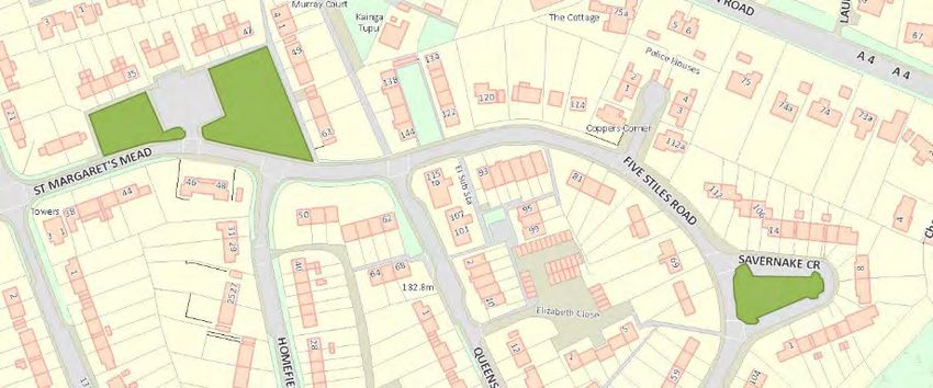
Policy MARL16: Protecting Local Green Spaces Details
Area Description 1 Owner Hectares NPPF Criteria for assessing Local Green Spaces 2
Test 1 Test 2 Test 3 Test 4
No Planning Close to Less 5 hectares & Special Value to Community
Community local in character
1. Cooper’s Meadow Park and MTC Park 0.8835
recreation MRA Beauty
Adjacent to Marlborough Town Centre ground Play Park History
and major car park - an attractive water combined 0.0319 Water meadow
meadow with a riverside walk with park MRA Recreation
benches and sheep grazing throughout Photograph Children’s play area
the summer. number Riverside park
Picnic area
Medium sized play area with play Tranquillity
equipment for young children. Quiet space in centre of
(Recently updated). town
Wildlife
River and meadow
environment
bees
Other
Sheep grazing
2. Salisbury Road Recreation Park and MTC 1.6128
Ground recreation Whole area Recreational value
ground (MRA) Bowls Club
Susanne Harris 20/01/2021 – Description of Open Spaces in MANP Area – Regulation 14 Page 4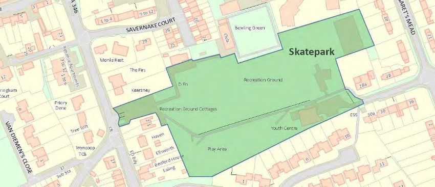
Area                        Description 1   Owner   Hectares        NPPF Criteria for assessing Local Green Spaces 2
                                                                                   Test 1       Test 2          Test 3                   Test 4
                                                                                 No Planning    Close to   Less 5 hectares &    Special Value to Community
                                                                                               Community   local in character
To the south east of Marlborough Town         combined Play                                                                     Youth and Community
Centre, Salisbury Road Recreation             space                                                                             Centre
ground is a large park with recreational      (Children)                                                                        Children’s Play Area
facilities and a full sized football pitch.                                                                                     Skate Park
                                                                                                                                Mini and full sized
Previous lack of mini football pitches                                                                                          football pitches
for younger players partially addressed                                                                                         MUGA
by overlaying or mini pitches across
existing adult pitch.

Toilets and changing facilities for                                                                                             Also is the base for MTC
Marlborough Youth Football Club are                                                                                             Estate Management
accessible at Youth and Community                                                                                               resources
Centre.

A wide range of play equipment is
available for toddlers and juniors.
Some of the equipment is suitable for
older children to use as fitness
equipment.

There is also a bowls club sited within
the recreation ground.

A rare facility of a skateboard park for
older children and teenagers is situated
near to the Youth and (continued)
Community Centre.

N.B. No planning at present but
possible car park extension in the

Susanne Harris 20/01/2021 – Description of Open Spaces in MANP Area – Regulation 14                                                                Page 5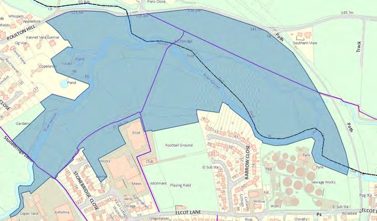
Area Description 1 Owner Hectares NPPF Criteria for assessing Local Green Spaces 2
Test 1 Test 2 Test 3 Test 4
No Planning Close to Less 5 hectares & Special Value to Community
Community local in character
future
3. Victorian Cemetery Churchyards MTC 0.9877
and Cemeteries (MRA) Beauty
A conservation project situated Trees, some flora and
amongst the mature trees of the fauna
Victorian Cemetery, dating from c 1853. History
War graves, communal
There are a range of funereal graves of work house
monuments – some elaborate and incumbents, memorial
some simple – showing historic links to stones, foundations of
local families and businesses and chapel
reflecting the use of nearby buildings Tranquillity
such as the workhouse and St Luke’s Yes
Children’s Hospital. Wildlife
Trees, wildflowers, birds
Rich in history, flora and fauna this
example of a Wiltshire Living
Churchyard is maintained by a
voluntary group – Friends of Victorian
Cemetery – which includes Town
Councillors and local people.
4. Jubilee Field at Manton Park and In trust to 0.7301
recreation MTC MRA Beauty
Owned by Marlborough Town Council, ground Trees, stream
Susanne Harris 20/01/2021 – Description of Open Spaces in MANP Area – Regulation 14 Page 6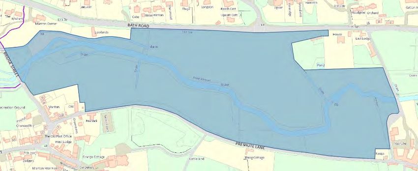
Area Description 1 Owner Hectares NPPF Criteria for assessing Local Green Spaces 2
Test 1 Test 2 Test 3 Test 4
No Planning Close to Less 5 hectares & Special Value to Community
Community local in character
the field is an open space including an combined Rec sig
informal football pitch and games area Children’s playground,
and frequently used by dog walkers and Muga, riverside walk to
people accessing a right of way. right of way, local
school football area
It has park benches and trees and Tranquillity
children are able to access the River yes
Kennet which forms the north
boundary. There is a small, enclosed
play area consisting of swings, a slide
and a climbing frame.
The field is often used by the local
primary school and by parents and
children after school. (An upgrade of
play equipment is planned).
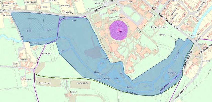
5. Priory Gardens Amenity Green MTC 0.8289
Space (Public MRA Beauty
A garden with public access, given to Open Space) Large garden with trees
the town in 1930, with benches, picnic (some TPO) and mixed
tables, large lawns and floral displays. boarders of shrubs and
flowers
With the River Kennet running along its History
edge - a quiet retreat from the bustle of Part of Priory House
the High Street. Rec sig
Riverside walk,
Benches and seats ,
Large grassed area used
for concerts
Tranquillity
Yes
Susanne Harris 20/01/2021 – Description of Open Spaces in MANP Area – Regulation 14 Page 7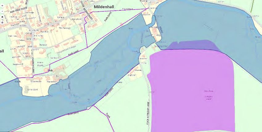
Area Description 1 Owner Hectares NPPF Criteria for assessing Local Green Spaces 2
Test 1 Test 2 Test 3 Test 4
No Planning Close to Less 5 hectares & Special Value to Community
Community local in character
6. Wye House Gardens and Play Play space WC and 0.2308
Area (Children) leased to (MRA) Beauty
MTC Kept garden
Small play area with equipment, for Rec sig
young children and an enclosed garden Children’s Play Area
and a pond. Tranquillity
Pond, trees, seating
Wildlife
Pond life, birds,
7. Land at College Fields/Barton Public Open WC 1.7616
Park Space Rec sig
(MRA) Used by dog walkers and
Susanne Harris 20/01/2021 – Description of Open Spaces in MANP Area – Regulation 14 Page 8Area Description 1 Owner Hectares NPPF Criteria for assessing Local Green Spaces 2
Test 1 Test 2 Test 3 Test 4
No Planning Close to Less 5 hectares & Special Value to Community
Community local in character
A grassed area used for walking and children – limited
playing informal games recreational use.
(near Betjeman Road)
MANP recognise that
G11 the local community has
recreational needs.
8. The Green Amenity Green MTC West
Space (Public 0.2010 Beauty
Green open space with benches and Open Space East Green open space, row
surrounded by a variety of listed 0.1418 of lime trees,
buildings. MM surrounded by listed
buildings
An avenue of lime trees dating from History
1840. Building foundations
underneath, possibly
Area used for dog walking, picnicking, the site of original town
etc.
Policy MARL17: Protecting Valued
Community Open Spaces
Susanne Harris 20/01/2021 – Description of Open Spaces in MANP Area – Regulation 14 Page 9Area Description 1 Owner Hectares NPPF Criteria for assessing Local Green Spaces 2
Test 1 Test 2 Test 3 Test 4
No Planning Close to Less 5 hectares & Special Value to Community
Community local in character
1. Orchard Road Play Area Play space MTC 0.0192
(Children) MRA Recreation
Recently updated small play area with Children’s Play Area
equipment suitable for young children.
2. Land at St Margaret’s Mead Amenity Green MTC 0.0825
Space (Public MMG17A Recreation
Opposite shop – West side Open Space
Open space since estate
built in early 1950’s
3. Land at St Margaret’s Mead Amenity Green MTC 0.1856
Space (Public MM G17B Recreation
Opposite shop – East side Open Space
Open space since estate
built in early 1950’s
4. Land at St Margaret’s Mead Amenity Green MTC 0.684
Space (Public MM G17C Recreation
Savernake Crescent Open Space
Open space since estate
built in early 1950’s
5. St John’s Park Play Area Play space 0.2388
(Children) MM G20 Recreation
Small area for young children with play
Susanne Harris 20/01/2021 – Description of Open Spaces in MANP Area – Regulation 14 Page 10Area Description 1 Owner Hectares NPPF Criteria for assessing Local Green Spaces 2
Test 1 Test 2 Test 3 Test 4
No Planning Close to Less 5 hectares & Special Value to Community
Community local in character
equipment Children’s Play Area
6. Plume of Feather’s Lane Garden MTC 0.1137
Garden MRA Beauty
Garden
Private garden, owned by Marlborough Rec sig
Town Council. A Mental Well-Being Charity Use
support amenity garden also used by Tranquillity
local primary school. Yes
Wildlife
Not generally open to the public Garden Birds
although sometimes used by local Insects
people.
7. Tinpit - land containing Amenity Green MTC 0.1952
Scheduled Ancient Monument Space (Public MRA On edge Beauty
G25 Open Space) of town Views of Rabley Wood
Susanne Harris 20/01/2021 – Description of Open Spaces in MANP Area – Regulation 14 Page 11Area Description 1 Owner Hectares NPPF Criteria for assessing Local Green Spaces 2
Test 1 Test 2 Test 3 Test 4
No Planning Close to Less 5 hectares & Special Value to Community
Community local in character
A green space on the north east of but Water meadow of the
town, with the River Og running accessible river Og
through it - there's a path to allow the History
public to access the river and Scheduled Monument
a scheduled ancient Tranquillity
monument adjacent to the site. yes
Wildlife
The monument of the Medieval period Water meadow
was a fish pond used to provide fresh environment
fish for the inhabitants of Marlborough
Castle. An earthen dam, sometimes
called a bay, was raised across the Og
to make a long narrow lake, which
extended north to Bay Bridge.
http://www.marlboroughhistorysociety
.co.uk
The dam north of the River Og is extant
whereas south of the river it is no
longer visible.
8. Mildenhall - Play Area Play Space MPC 0.1952
(Children) MM G25 Recreation
Small play area with play equipment for Only children’s play area
young children in Minal
9. Kennet Place - Waterside Community tbc
Garden Space Beauty
Garden Garden in a riverside
Susanne Harris 20/01/2021 – Description of Open Spaces in MANP Area – Regulation 14 Page 12Area Description 1 Owner Hectares NPPF Criteria for assessing Local Green Spaces 2
Test 1 Test 2 Test 3 Test 4
No Planning Close to Less 5 hectares & Special Value to Community
Community local in character
A community garden on the bank of the setting
river Kennet. Developed and Constructed and
maintained by volunteers and enjoyed cared for by
by local people and visitors. local residents
for use and
valued by the
community
tbc
10. Land at College Fields/Barton Public Open
Park Space Recreation
Informal recreation area
Bensen Close used by the community
A grassed area used for walking and
playing informal games
Public Open tbc
11. Land at College Fields/Barton Space
Park Recreation
Informal recreation area
Macneice Drive used by the community
A grassed area used for walking and
playing informal games
Public Open tbc
12. Land at College Fields/Barton Space
Park Recreation
Informal recreation area
Susanne Harris 20/01/2021 – Description of Open Spaces in MANP Area – Regulation 14 Page 13Area Description 1 Owner Hectares NPPF Criteria for assessing Local Green Spaces 2
Test 1 Test 2 Test 3 Test 4
No Planning Close to Less 5 hectares & Special Value to Community
Community local in character
Hawkins Meadow used by the community
A grassed area used for walking and
playing informal games
13. Bath Road Triangle Public Open MTC tbc
Space with
Small piece of land off Bath Road west bench and Beauty
of College Water Meadow (near attractive views History
Memorial Hall) grassed and with seat of Marlborough College water meadow
College and historic buildings
(Memorial Hall,
Chapel, Arch,
Field House)
14. Minal – Land North of St John Public Open Minal 0.5900
The Baptist Church Space Parish MM Tranquillity
(with Scheduled Ancient Monument) Council History
Public access with Right
of Way and access to
Church from field and
Scheduled Ancient
Monument (Possibly
Ditch and Bank)
15. Maurice Way Green – Parcel 1 Public Open SPC(tbc) tbc
Space Recreation
Informal recreation area
used by the community
Susanne Harris 20/01/2021 – Description of Open Spaces in MANP Area – Regulation 14 Page 14Area Description 1 Owner Hectares NPPF Criteria for assessing Local Green Spaces 2
Test 1 Test 2 Test 3 Test 4
No Planning Close to Less 5 hectares & Special Value to Community
Community local in character
16. Maurice Way Green – Parcel 2 Public Open SPC(tbc) tbc
Space Recreation
Informal recreation area
used by the community
17. Land at Cadley Open Space SPC(tbc) tbc
On the western side of the A346 from Adjacent to History
Cadley Garage to Dobie and Wyatt’s Savernake Informal recreation area
Forest and used by the community
setting for
cottages and
significant
house
18. The Pound, Manton Anomaly - Map MTC(tbc) tbc
Rough grassed area with historic does not match
significance status (used for penning with Kennet History
escaped animals while awaiting District Council
collection by their owners) Conservation
Located between Odd Fellows Arms Area Map which
Public house garden and carpark and shows this as to
Jubilee Field Play area. the side of
Map no. G12 but not marked up or ‘Emily’s Cottage’
measured
19. Manton Green Public Open MTC(tbc) tbc
Space
Small grasses History
area with seat Original centre of village
Susanne Harris 20/01/2021 – Description of Open Spaces in MANP Area – Regulation 14 Page 15Area Description 1 Owner Hectares NPPF Criteria for assessing Local Green Spaces 2
Test 1 Test 2 Test 3 Test 4
No Planning Close to Less 5 hectares & Special Value to Community
Community local in character
and notice Tranquillity
Map no. G12 but not marked up or board. Good A small quiet oasis
measured (LB) views of original
centre of village
with associated
cottages and
community
buildings
20. War Memorial, London Road 1st World War MTC tbc
Memorial with
garden History
Contributes to the
setting significant older
buildings including
previous farmhouse
Susanne Harris 20/01/2021 – Description of Open Spaces in MANP Area – Regulation 14 Page 16(Continued) List of Green Spaces with existing protection Common Elcot Lane Village Green Stone Bridge Lane Water Meadows Stone Bridge Lane Nature Reserve Stone Bridge Lane Allotments Elcot Lane Allotments St John’s Close Allotments St Mary’s Church Yard, Marlborough St Peter’s and St Paul’s Church Yard, Marlborough St Mary’s Church Yard, Minal Minal Cricket Pitch Marlborough Cricket Pitch (Behind Savernake Hospital) Susanne Harris 20/01/2021 – Description of Open Spaces in MANP Area – Regulation 14 Page 17
Open Space Lists
Protecting Valued Community Spaces (MA17)
   1. Orchard Road Play Area (between Orchard Road & Upper Churchfields following line
      of MARL30 footpath).

                                   Orchard Road Play Area

   2. Small Pieces of Land at St. Margaret’s Mead
        a. East of car park opposite local shop
        b. West of car park opposite local shop
        c. Savernake Crescent

                                    St. Margaret’s Mead

   3. St. John’s Park Play Area (adjacent to White Horse Road).

                                   St. John’s Park Play area

   4. Plume of Feathers Garden.

Page 1 of 16
Plume of Feathers Garden
5. Tin Pit, land next to the River Og – Scheduled Monument
Tin Pit
6. Mildenhall (Minal) Play Area (between Thicketts Road & Old Ford Cottage).
Mildenhall (Minal) Play Area
7. Kennet Place Waterside Garden (on corner adjacent to former rope works).
Kennet Place Waterside Garden
Page 2 of 168. Small pieces of Land at College Fields / Barton Park
a. Betjeman Road
Betjeman Road
b. MacNeice Drive
MacNeice Drive
c. Hawkins Meadow
Hawkins Meadow
9. Small piece of Land next to the A4 at Manton (Bath Road Triangle).
Bath Road Triangle
10. Land North of Minal Church (Monument)
Page 3 of 1611. Maurice Way Green spaces (to north of Savernake Hospital)
a. End of Maurice Way – southern spur.
b. End of Maurice Way – northern spur.
Maurice Way Green spaces
12. Cadley – Wooded strip of land paralleling the western side of the A346 road through
Savernake Forest. Stretching from land opposite Salisbury Road Lodge
(Marlborough/Savernake parish boundary) southeast to Leigh Hill
(Savernake/Burbage parish boundary)
13. Pound at Manton
14. Manton Green
15. London Road War Memorial
Page 4 of 16Policy MARL 16 Protecting Local Green Spaces
1. Cooper’s Meadow
Cooper’s Meadow
2. Salisbury Road Recreation Ground.
Salisbury Road Recreation Ground
3. The Victorian Cemetery.
The Victorian Cemetery
4. Jubilee Field, Manton.
Manton Jubilee Field
Page 5 of 165. Priory Gardens.
Priory Gardens
6. Wye House Garden and Play Area
Wye House Garden
7. Land at College Fields / Barton Park.
College Fields - Barton Park
8. The Green, Marlborough.
The Green
Page 6 of 16Policy 18 – Conserving Scenic Beauty of the AONB
Policy 18 Conserving the Scenic Beauty of the AONB
1. Marlborough Downs and The Common
2. Savernake Forest and Plateau
3. Kennet Valley and Og Valley:
a. North & South of the River Kennet at Manton.
Water Meadow at Manton
b. North and South of the River Kennet at Preshute Lane.
Water Meadow at Preshute Lane
c. West of the River Og from Marlborough to Bay Bridges.
North
Central South
Og Water Meadows from Bay Bridges to Kennet River
Page 7 of 16d. Stonebridge Lane Water Meadows.
Water Meadows at Stonebridge Lane
Page 8 of 16e. North and South of the River Kennet between Marlborough and Mildenhall
parish boundary at Axford.
Water Meadow between Marlborough & Mildenhall (West)
Water Meadow at Mildenhall (Centre)
1Water Meadow between Mildenhall & Stitchcombe (East)
Page 9 of 16f. North and South of the River Kennet at Treacle Bolly.
Water Meadow at Treacle Bolly
4. Three Cornered Meadow – Land to south of London Road & to southeast of cycle
path
5. Savernake Forest Northern Escarpment – North-West facing continuous escarpment
from Pantawick along edge of Savernake Plateau to Mildenhall/Axford parish
boundary at Stitchcombe.
N.B. Insert Granham Hill to Manton Grange Escarpment + map.
Page 10 of 16Savernake Parish Valued Landscapes.
6. Furze Coppice, Savernake parish. South of A345 at Clench Common)
7. Withy Copse, Savernake parish. North of Martinsell Hill & Square Plantation,
bounded by footpaths SAVE31, SAVE30 & PEWS69.
8. Brick Hill Copse, Savernake parish. North of Mud Lane (footpath WRVI3).
Mildenhall Parish Valued Landscapes.
9. Rabley Wood, Mildenhall parish. Next to Rabley Barn.
10. Poulton Spinney, Mildenhall parish. West of Poultry House & Rabley Hill. Southwest
of Rabley Wood.
11. Lopthorn Copse, Mildenhall parish. West of footpath MILD3.
12. Well Ground Copse, Mildenhall parish. South of Dean Lane (MILD6).
13. Sound Copse, Mildenhall parish. To southeast of Mere Farm, north of footpath
MILD6, to west of Mildenhall parish boundary.
14. Thicket Copse, Mildenhall parish. North of Thicketts Road & east of footpath MILD10.
15. Upper Thicket Copse, Mildenhall parish. North of Thicket Copse & east of footpath
MILD10.
16. East Croft Coppice, Mildenhall parish. North of London Road A4, west of parish
boundary & footpath MILD16.
17. Oxleaze Copse, Mildenhall parish. North of footpath MILD15, west of MILD16.
18. Folly Copse, Mildenhall parish. South of footpath MILD14, west of MILD17 (Cock-a-
Troop Lane)
Land with Existing Protections (part of MA14)
1. Stonebridge Lane Allotments.
2. Elcot Lane Allotments.
3. St John’s Close Allotments and Community Space.
4. St Mary’s Church Yard.
5. St Peter’s Church Yard.
6. St John the Baptist Churchyard, Mildenhall.
7. St George’s Churchyard, Preshute.
Page 11 of 168. Elcot Lane Village Green.
9. Mildenhall – Cricket Pitch.
10. Savernake – Marlborough Cricket Ground.
11. Marlborough College Sports Fields (between Barton Dene [Marl43] & Hyde Lane
[Marl5] / Leaze Road [Marl7].
12. Marlborough College Tennis Courts / Playing Fields South of Treacle Bolly [Marl33] &
east of footpath Marl37.
13. St John’s Academy Sports Field to southeast of Granham Hill.
14. Marlborough Town Football Club Pitch at Elcot Lane.
MA15 – Protecting and Improving Green Infrastructure
This policy explores the connectivity between our open spaces, in the form of footpaths and
cycle ways and identifies where there are missing links that would benefit the community if
added. It also explores the important wildlife corridors between our green spaces that are to
be protected.
During future developments the MANP recommends that the opportunity should be taken to
promote sustainable movement and ecological connectivity through the town and
neighbouring parishes to assist in mitigating climate change and provide safer, less polluted
walking and cycling routes.
The following possible routes have been identified:
1. River pathway from Stonebridge Lane to Kelham Gardens, south-east of Rawlings
Well.
This would enable pedestrians and cyclists to access the town centre from the east of
the town (and further afield via the Marlborough to Chiseldon Railway Path) to Wye
House away from air pollution and other dangers from traffic on the A4.
Page 12 of 162. Extension of the Marlborough to Chiseldon Railway Path from its present termination
point at Queensway to Salisbury Road Business Park.
The extension would deliver safe cycling and walking access to business and shops and
potentially a safer route for students attending St John’s Academy.
3. Path following southern edge of Marlborough to Mildenhall Road.
To facilitate safe walking and cycling between Mildenhall to the centre of Marlborough
Town, local schools and other facilities a suitable pathway is needed from the road
bridge over the Marlborough to Chiseldon Railway Path west to the river bridge at
Poulton. This has a 60 mph speed limit.
Page 13 of 16Important Wildlife Corridors
1. River Kennet
2. River Og
3. Western boundary of Marlborough – Line of Beech hedging from Downs Lane south
to Bath Road.
4. Northern boundary of Marlborough - Hedged Bridleway & line of mature mixed
woodland running from Manton across the northern edge of Land at College
Fields/Barton Park to Barton Dene.
5. Marlborough to Pewsey Bee Road (Granham Hill to Pewsey Road)
6. Marlborough to Beckhampton Bee Road (Bath Road at Manton)
7. Banks next to cycle path (Chiseldon & Marlborough Railway Path)
a. London Road via Stone Bridge Lane to Poulton Hill (Marlborough to
Mildenhall Road)
b. Poulton Hill to Mildenhall Parish boundary.
Page 14 of 168. Tree line from “Marlborough Railway Tunnel County Wildlife Site Bat Habitat” to
Savernake Forest (Salisbury Hill).
9. Banks next to Marlborough to Mildenhall footpath MILD25.
10. Tree Sparrow Corridor to the north of Frees Avenue (Rockley Road) to Preshute
parish boundary.
Rockley Road Tree Sparrow Corridor
Page 15 of 16Notes: 1) All public rights of way, notified tracks, & position measurements have been determined using the Wiltshire Council Planning Explorer: http://wiltscouncil.maps.arcgis.com/apps/webappviewer/index.html?id=74a353612a934b d48fee1f2bc564cdd8 2) All designated rights of way have been determined using the Wiltshire Council Rights-of- Way Explorer: http://wiltscouncil.maps.arcgis.com/apps/webappviewer/index.html?id=43d5a86a545046 b2b59fd7dd49d89d22 To re-centre both apps from County Hall to Marlborough, click on the bookmarks icon , scroll down to Marlborough & click on the displayed link. 3) Lists within this document are not exhaustive. 4) Boundaries & borders shown in this document are approximate. 5) Land identified as “Water Meadow” covers areas greater than the water meadows themselves. Professional advice regarding water meadow habitat should be referred to for any detailed assessment. 6) Land identified as the Northern Escarpment to the Savernake Forest is approximate & will be more extensive than that shown. Page 16 of 16
Marlborough Area Neighbourhood Plan

Technical information to support Policy 18: Conserving the Scenic Beauty of
the AONB
MANP policy MARL 18: Conserving the Scenic Beauty of the AONB seeks to prevent harmful
development proposals outside the defined Marlborough development boundary including:

       the Northwest facing escarpment from Pantawick along the edge of the plateau to the
       Mildenhall and Axford parish boundary at Stitchcombe including Three Cornered Meadow

       the North facing escarpment from Granham Hill to the settlement boundary at West
       Manton.

The north-west and north facing escarpment, from Pantawick in the west to the Mildenhall and
Axford parish boundary at Stitchcombe in the east, defines the edge of the Savernake plateau and
Forest and provides a natural and historic southern landscape setting for Marlborough and
Mildenhall. This land which rises steeply above the River Kennet Valley is a continuous green
elevated sweep forming a natural divide between the developed settlements of Marlborough and
Mildenhall and the ancient Savernake Forest. This escarpment is within the North Wessex Downs
Area of Outstanding Nature Beauty adjoining the World Heritage Site of Avebury and other historic
sites. Although the whole escarpment is afforded protection through its AONB status (see appendix
1), one section has already been offered for possible development involving land known locally as
Three Cornered Meadow. This meadow is part of the section of the escarpment that runs from the
A346 in the west at Postern Hill to the A4 in the east and provides a natural buffer between
Savernake Forest and the southern edge of the built environment of Marlborough.

A second north facing escarpment, from Granham Hill (A345 Pewsey Road) to the settlement
boundary at West Manton, is also part of the North Wessex Downs AONB and closer to the wider
setting of the Avebury World Heritage Site. At its eastern end the escarpment is the southern
landscape setting for the Marlborough College grounds with the Marlborough Mound which is an
important archaeological monument together with listed buildings and gardens.

Both escarpments are important parts of the green infrastructure of the MANP area and provide
public access to a biodiverse and historic landscape and recreational opportunities from its many
footpaths, bridleways and rights of way. The Pantawick to Stitchcombe escarpment is about 2.5
miles in length and the escarpment from Granham Hill to the Settlement boundary at West Manton
is just over a mile.

This report seeks to provide technical evidence to support the MANP Policy MARL18 to prevent
undesirable development on valued green spaces and preserve both escarpments from

Susanne Harris 23/11/2020 – Seagate – MANP – Reg 14 - Technical Information to support
Policy 18                                                                           Page 1
development that will damage the landscape settings of Marlborough, the villages of Mildenhall and
Manton, Savernake Forest, Marlborough College and the wider landscape setting of the World
Heritage Site of Avebury.
The main problem encountered by development on the North Wessex Downs AONB is illustrated by
the current Marleberg Grange development, to the west of the A346 at Postern Hill, on the lower
flank of the Pantawick to Stitchcombe escarpment at this location. Planning guidance keeps the
roof line below the 160m AOD Contour and the existing 20 metre wide southern tree belt protects
views from the north, north- west and west viewpoints. The land on the edge of the escarpment
from Pantawick to Stitchcombe, specifically east of the A346, is narrower and steeper than that at
the Marleberg Grange development and as a result is more visible in the AONB landscape from the
north, north- west and east of Marlborough. The land on which the Salisbury Road Business Park is
built, to the north of the escarpment, has been lowered during development and the roof lines of
the buildings are more in line with the 150m AOB Contour and as such the development does not
encroach on the escarpment and is not visible from the northern aspects of the town.
This report will present technical evidence arising from:
• the Wiltshire Council Strategic Planning Report for Marleberg Grange
(https://unidoc.wiltshire.gov.uk/UniDoc/Document/File/MTUvMDIwMjYvT1VULDY5MzU4N
Q==)
• the North Wessex Downs AONB 2019–2024 Management Plan
• comments and guidance from other stakeholders
• Stonehenge and Avebury WHS Management Plan 2015 (part 2)
• Wiltshire Council Core Strategy
In the Wiltshire Council Report to the Strategic Planning Committee dated 10th February 2016 -
Land West of Salisbury Road, Marlborough (Marleberg Grange) Wiltshire - paragraph 9.1 Principle
of Development (Page 9) sets out the intention to:
Create development that relates well to the town, ensuring minimal impact upon
Marlborough’s rich built, historic and landscape assets (WCS, p248).
Within the same document (page 11) under Landscaping & Visual Impact the following is recorded:
The supporting text to Core Policy 51 highlights that when determining proposals in AONBs
great weight will have to be given to conserving the landscape and scenic beauty in
accordance with paragraphs 115 and 116 of the NPPF. The NPPF states that AONBs have the
highest status of protection in relation to landscape and scenic beauty and the presumption
in favour of sustainable development does not apply within these areas’. Paragraph 116
outlines that ‘planning permission should be refused for major developments in these areas
except in exceptional circumstances and where it can be demonstrated they are in the public
interest.
The document continues ‘The Council’s Landscape and Design Officer carried out a detailed
assessment of the proposed development and originally objected to the application’. It was noted
Susanne Harris 23/11/2020 – Seagate – MANP – Reg 14 - Technical Information to support
Policy 18 Page 2that ‘the application proposes the introduction of built development which is located too far up the
southern slope of the application site’s western field. The resulting landscape and visual effects are
considered to generate unacceptable and unnecessary harm to landscape character and visual
receptors within the nationally designated North Wessex Downs AONB’.
Insert map of both escarpments showing 150m AOD Contour.
The North Wessex Downs AONB Unit also objected to the original plans for the proposed
development on the grounds that ‘it would fail to conserve and enhance the natural beauty of this
nationally protected landscape, contrary to the purposes for which the area is designated and the
statutory duty of regard placed upon the local planning authority under s. 85 of the Countryside and
Rights of Way Act 2000’. This view was also shared by Natural England who considered that ‘the
proposed development would have a significant adverse effect on the AONB’. …
In response to these objections a section of the proposed development on the land that rises to the
south in the west of the site was removed to ensure that it did not exceed the 160m AOD contour,
this being the elevation ‘at which glimpsed or partial views of buildings could otherwise have been
possible from a number of viewpoints’.
In the same Wiltshire Council report for Marleberg Grange (page 12) it states:
Based on the information submitted it is considered that a suitably worded planning
condition stating that built development must not exceed ‘the existing 160m AOD contour’
in line with the submitted ‘Vertical and horizontal landscape parameters plan’ (Fig. 7) &
‘Land Use and Building Height Parameters Plan’ (Fig. 8) should prove effective in minimising
and controlling the visual impacts of the proposed development within any subsequent
detailed ‘Reserved Matters’ application proposal. This combined with the addition of the 20
metre wide southern tree belt and other ecological parameters will both constrain and
restrict built development further south.
These revisions and additions to the application proposal should give the Council the
necessary comfort and control to ensure that development will not result in harm to wider
landscape character or be visible from important visual receptors. The revised masterplan
layout (Fig. 3) also increases the stand-off to Savernake Forest, which better conserves the
visual and physical setting to the forest and removes the urban influence of new built form
on the higher land from longer distance visual receptors i.e. Marlborough Common (north),
from further afield (north–west) and also from the college road junction (west).
The AONB Unit’s response is detailed in page 13:
The AONB unit accepts that the revised proposals would reduce the likely impact compared
with the earlier submission, however they feel that “the landscape justification for the
revised proposals remains fundamentally flawed because it implies that localised impact on
landscape character and special qualities is not significant if (as is claimed) development
does not compromise the wider landscape. Every part of the AONB enjoys the same
protected status. Inevitably, development of the allocated site will result in major negative
impact on the designated landscape. The objective should be to confine this visual impact to
as small a part of the AONB as possible. The key to this is heights, and specifically the
contours above which development will or will not be visible from a wider area”. It is
Susanne Harris 23/11/2020 – Seagate – MANP – Reg 14 - Technical Information to support
Policy 18 Page 3therefore recommended that any development and associated lighting should not extend
beyond the 150m AOD contour line as development above is “very likely to give rise to
unacceptable impacts on the wider protected landscape”.
The AONB Unit submitted this strong objection to the Marleberg Grange development:
‘ …. extending the proposed built development edge south of the 150m contour will
adversely affect the rural elevated character of the AONB southern valley slopes and setting
to the forest and undermine the enclosed and otherwise self contained nature of this
allocated development site’.
In page 18 of the same report to the Strategic Planning Committee Historic England responded:
Historic England identified the key heritage assets which the development (Marleberg
Grange) may affect within their consultation response which included the Marlborough
town centre and the Conservation Area, Tottenham House and Savernake Forest (a Grade II*
registered Historic Park and Garden). Historic England concluded that “the impacts of this
development on the registered Park of Savernake Forest will have some impact on its
setting, this is borne out by the proximity of the development to the edge of the Forest and
how this is read in distant views from the hills on the north side of the town. The impact will
be particularly exaggerated at night when the night glow from the additional lights in this
part of the landscape will impact upon the dark skies that surround the Park and contribute
to its rural setting.”
The green infrastructure and rich natural environment of the area is of great value. The Kennet
Local Plan is still influential today and has been adopted into the Wiltshire Core Strategy which is
now part of the developing Wiltshire Local Plan. The Kennet Local Plan Marlborough Central Area
Map shows part of the escarpment in question to be:
• An area of minimum change and Landscape Setting (NR 10)
• Site of Special Scientific Interest (NR2)
• Area of High Ecological Value (NR3)
The Pantawick to Stitchcombe escarpment is also part of the landscape setting of Savernake Forest
and therefore the setting of the registered Historic Park and Garden of Tottenham House.
The European Landscape Convention promotes landscape protection. It states:
The principal pressure on the landscape arising from new development is erosion of the
separate identity, character, visual and functional amenity of settlements and their setting,
and impacts on the open countryside. Another challenge is to allow for appropriate
development while having full regard to the conservation and enhancement objectives of
the most highly valued landscapes including the Areas of Outstanding Natural Beauty……….
and Avebury World Heritage Site (WHS).
Susanne Harris 23/11/2020 – Seagate – MANP – Reg 14 - Technical Information to support
Policy 18 Page 4Whilst not within the specific World Heritage Site of Avebury, areas of the North Wessex Downs
including both escarpments are part of the continuous and indivisible landscape of the WHS. It can
be seen from as far away as Overton Hill (five miles away) and Oldbury Castle (nine miles away).
Any development here would infringe on the long view from those sites and continue the built
environment of Marlborough into an area that can be seen for many miles and from local vista
views within the town itself.
The Wiltshire Council Core Strategy - strategic Objective 5 - encourages the protection and
enhancement of the natural, historic and built environment.
Ecological Constraints Notes from Wiltshire Council’s Economic Development and Planning
Department includes:
Land south of London Road (Three Cornered Meadow) would likely not be developable,
since it lies mainly within Postern Hill Chalk County Wildlife Site and loss of this local wildlife
site would be contrary to Wiltshire core Policy 50.
To summarise, this report presents strong evidence that any development on the escarpments will
cause loss of community amenity value and visual harm to:
• Savernake Forest
• the Historic Park and Garden of Tottenham House
• the landscape setting of Marlborough College including the Marlborough Mound, Park and
Garden of special historic value and listed buildings
• the Marlborough and Manton Conservation Areas
• the small village status of Manton and Mildenhall
• the environmentally sensitive areas of SSSI, Minimum Change and High Ecological Value
• the County Wildlife Site status, historic and archaeological sites
• the wider North Wessex Downs Area of Natural Beauty and the landscape setting of
Avebury WHS.
Consequently, it is proposed that the Marlborough Area Neighbourhood Plan Policy MARL 18 should
state that:
No built development should exceed the 150 metre AOD contour on both the north and
northwest facing escarpment from Pantawick in the west to the Mildenhall and Axford parish
boundary at Stitchcombe in the east and the north facing escarpment from Granham Hill in the
east to the settlement boundary at West Manton in the west.
Susanne Harris 23/11/2020 – Seagate – MANP – Reg 14 - Technical Information to support
Policy 18 Page 5Appendix
National Planning Policy Framework - policy on AONBs
115. Great weight should be given to conserving landscape and scenic beauty in National Parks, the
Broads and Areas of Outstanding Natural Beauty, which have the highest status of protection in
relation to landscape and scenic beauty. The conservation of wildlife and cultural heritage are
important considerations in all these areas, and should be given great weight in National Parks and
the Broads.
116. Planning permission should be refused for major developments in these designated areas
except in exceptional circumstances and where it can be demonstrated they are in the public
interest. Consideration of such applications should include an assessment of:
• the need for the development, including in terms of any national considerations, and the
impact of permitting it, or refusing it, upon the local economy;
• the cost of, and scope for, developing elsewhere outside the designated area, or meeting
the need for it in some other way; and
• any detrimental effect on the environment, the landscape and recreational opportunities,
and the extent to which that could be moderated.
Susanne Harris 23/11/2020 – Seagate – MANP – Reg 14 - Technical Information to support
Policy 18 Page 6Marlborough Area Neighbourhood Plan
Needs of Local Sports Organisations
Aim: To establish the needs of local Sports organisations with the intention of consolidating and
improve local sports facilities – identifying opportunities for co-location or new location of facilities.
Introduction
Sports and physical activities play an important role in the promotion of physical and mental health
and social well-being of the whole community. National and Local Government policies encourage
participation in physical activity to promote healthy lifestyle choices for all ages.
To this end the Revised National Planning Policy Framework, 2018 (section 91 Promoting Healthy
and Safe Communities) states:
Planning policies and decisions should aim to achieve healthy, inclusive and safe places
which enable and support healthy lifestyles, especially where this would address identified
local health and well-being needs – for example through the provision of safe and accessible
green infrastructure, sports facilities, local shops, access to healthier food, allotments and
layouts that encourage walking and cycling.
Section 92 continues: ‘to provide the social, recreational and cultural facilities and services the
community needs, planning policies and decisions should:
a) plan positively for the provision and use of shared spaces, community facilities (such as local
shops, meeting places, sports venues, open space, cultural buildings, public houses and
places of worship) and other local services to enhance the sustainability of communities and
residential environments;
b) take into account and support the delivery of local strategies to improve health, social and
cultural well-being for all sections of the community;
c) guard against the unnecessary loss of valued facilities and services, particularly where this
would reduce the community’s ability to meet its day-to-day needs’.
Feedback from the Marlborough Area Neighbourhood Plan Consultation Events and individual
consultations with local sports organisations have contributed to the identification of needs
highlighted within this report. Consideration is also given to the Wiltshire Playing Pitches Strategy
(WPPS).
Susanne Harris 09/10/20 Seagate Design and Environmental Local Sporting Facilities Page 1Feedback from Public Consultation Events
Five public consultation events were held at Marlborough, Manton Fest (Music Festival in Preshute
Parish), Manton Village, Minal Parish and Savernake Parish which constitute the area covered in the
Marlborough Area Neighbourhood Plan (MANP). Comments recorded from these events included
concerns that sporting facilities in the MANP area were not adequate or diverse enough for present
needs.
MANP Consultations with Sports Organisations and Identified Needs
As with many towns and villages, sporting facilities in the MANP Area have developed piecemeal
over many decades and are presently situated on fragmented sites that include schools,
Marlborough Town Football Club, The Common, The Recreation Ground, Elcot Lane Village Green,
Savernake Cricket Pitch and Minal Sports Ground.
The feedback received from individual sports organisations are considered below and are grouped
under the locations that host their activities.
The Common
Marlborough Golf Club has its club house and part of its golf course sited on The Common which is
owned by Marlborough Town Council. The remainder of the golf course is sited on land owned by
the Golf Club.
Marlborough Tennis Club has recently re-located to a new site adjacent to Port Hill with six all-
weather courts, 4 with lighting and a small pavilion. They are sharing club house facilities with
Marlborough Golf Club to whom they are adjacent and from whom they lease the land where their
courts are situated. In the future they may be looking to share and upgrade facilities at the Golf
Club.
Marlborough Rugby Club (MRC) has had disjointed facilities over the decades with playing pitches,
changing rooms and meeting spaces in different locations. Before acquiring their present facilities
where the Club could ‘play, change and entertain all in one place’ (Marlborough Rugby Club website)
the Club played matches on the Common and used ex Grammar School facilities at Elcot Lane for
training and as a club house. The Club eventually gained permission to build a club house next to
the Common in 1990 and achieved this in 2000.
As the Rugby Club has recently gained promotion there is a demand for higher specification facilities.
The Club currently (at the time of writing) has 14 teams which includes 2 senior teams, 6 junior
teams from under 18’s to under 12’s and 6 mini teams from under 11’s to under 6’s with
approximately 300 children playing rugby alongside the adult teams.
They now consider their facilities to be inadequate as:
• parking is limited
• changing and showering facilities are insufficient
Susanne Harris 09/10/20 Seagate Design and Environmental Local Sporting Facilities Page 2• the land between the Club House and the pitches is separated by Free’s Avenue (a child has
been seriously injured in a Road Traffic Collision)
• rules around using common land means that equipment cannot be permanent
• pitches cannot be enclosed and therefore there are dog fouling issues.
Identified Needs for MRC
The pitches are in a poor condition, there is no flood lighting and changing rooms are inadequate.
The club has improved its league position and this requires better facilities.
Would like a stadium in or near Marlborough - conference and club house
Willing to share facilities with other groups, e.g. Marlborough Cricket Club
Marlborough Youth Football Club (MYFC)is the newest of the two football clubs within the town
and was formed in 2009. It has three sections:
1. Mixed Team (boys and girls)
2. Angels Team (all girls)
3. Walking Football Team.
They have around 460 children playing football with 14 teams ranging from under 5’s to under 18’s.
They currently play on pitches that are fragmented across numerous venues. Some of the pitches
are on the Common adjacent to the Rugby Club pitches. Other pitches and training grounds include
Elcot Lane Village Green, Salisbury Road Recreation Ground, Marlborough College (Astro Turf pitch
for winter training) the College Water Meadow Pitch. More recently MYFC are using two pitches at
Marlborough Cricket Club Grounds and another pitch at Minal Cricket Ground.
They have similar problems to the Rugby Club with:
• road safety issues when using the Common pitches
• they have no club house of their own
• pitches and training grounds are spread across many sites
• changing, toilet and showering facilities are insufficient or non-existent on some sites
• rules around using common land means that equipment cannot be permanent
• pitches cannot be enclosed and therefore there are dog fouling issues.
Identified Needs for MYFC
To establish either a single site venue for the whole club with clubhouse, changing
facilities, parking, kitchen, storage etc or a double venue site, split between the junior
and senior sections with amenities as above. They would wish to have a pitch for each
age group size between U5 and U18. This does not allowing for training. The pitches
would require 5 acres.
Susanne Harris 09/10/20 Seagate Design and Environmental Local Sporting Facilities Page 3Other sites within the town
Marlborough Town Football Club (MTFC), founded in 1871, has been playing at its Elcot Lane
ground since 1904. The facilities consist of a large football pitch and a substantial club house with
showers, changing facilities, an entertainment facility including a bar and a large hall and a car park.
It is adjacent to a water meadow, the Elcot Lane Village Green and Barrow Close residential area.
MTFC has one large pitch and a narrow area of ground for training.
MTFC had 5 teams as follows at the time of writing:-
1. First Team – adult males – Wiltshire Senior League - Premier Division
2. Reserves – adult males – Swindon and District Football League – Division 4
3. Athletico – Swindon Sunday League – Division 4
4. Ladies – Wiltshire County Women and Girls – Premier Division
5. Under 17/18’s – Youth Football League – Division 3.
MTFC have difficulties in the following areas:-
• Following the formation of the MYFC there are few young players feeding into the MTFC
teams
• To satisfy their existing needs and attract younger players MTFC wish to create additional
playing facilities
Identified Needs for MTFC
Use of additional land to provide training area and additional pitch
Elcot Lane Village Green is a former school playing field with Village Green Status and is owned by
Marlborough Town Council including a small pavilion which has been adapted into a boxing club.
The field is used on a regular basis by MYFC for training purposes and the junior football pitch is used
by MYFC for matches at the weekends. The Village Green is an unenclosed space and is accessed by
the general public for recreation and walking and as an informal Multiple Use Games Area (MUGA).
The Recreation Ground has a full sized football pitch which has recently been marked as 2 mini
pitches and is used by MYFC. The local Youth and Community Centre is located on this site and the
Council has recently given permission for teams to use the changing and toilet facilities there.
A small piece of land is available for development for other leisure activities.
Marlborough Cricket Club (MCC) has its main pitch in Savernake Forest on Forest Hill, east of
Marlborough. They share a club house with Marlborough Hockey Club who now plays at
Marlborough College. MCC also uses Minal Cricket Pitch for training. They would like to re-develop
their club house and other indoor facilities to provide female changing facilities and disabled access
to facilitate a wider variety of users. They also would like to build an indoor training facility at the
ground.
Susanne Harris 09/10/20 Seagate Design and Environmental Local Sporting Facilities Page 4Identified Needs for MCC
Ability to lease privately owned piece of ground adjacent to the existing pitches and club
facilities
Marlborough Hockey Club
Although the Hockey Club shares the clubhouse with MCC at Savernake they do not use it as they
play on pitches at Marlborough College.
Minal Cricket Club
Minal village has a large playing field, owned by the Gale Trust, which until recently was used by the
Minal Cricket Club whose membership numbers have declined. Following local concern about the
future of the sports field a new committee has been formed with the aim of retaining this valuable
14 acre field for sport and recreation in the future. The field us used by Marlborough Cricket Club
for training.
The Wiltshire Playing Pitches Strategy Action Plan (part 1) Strategic Recommendation 2 states:
In that, in the short term, Planning Policies should be developed for the conservation
and maintenance of playing pitches which should then be included in the Local
Development Plan
St John’s School (Excalibur Academy)
Within the school grounds are located two football pitches and two rugby pitches. The School also
has a large multi-sports hall. These facilities are hired to local clubs within the community.
Planning permission is being sought for two outdoor weather games courts and an additional sports
hall with changing rooms. These facilities will be available to local sports groups and community
groups for out of school hours. This will be in daylight hours only as the facilities are located close to
a sensitive ecology site.
The College
A number of local sporting organisations utilise facilities owned by Marlborough College who have
stated that their facilities are at full capacity. With the recent opening of an additional Girls’
Boarding House there is now a requirement for the College to provide further sporting facilities
which may result in external sports clubs needing to seek alternative grounds in the future and
thereby cause additional pressure on existing sports grounds in the town and neighbouring villages.
Susanne Harris 09/10/20 Seagate Design and Environmental Local Sporting Facilities Page 5You can also read