New hydrogeological results on the Groundwater Dependent Ecosystem of the Pilato Lake (Sibillini Mts, Central Italy) Nuovi risultati idrogeologici ...
←
→
Page content transcription
If your browser does not render page correctly, please read the page content below
DOI 10.7343/as-2022-551 2022-AS40-551: 27 - 35
journal homepage: https://www.acquesotterranee.net/
New hydrogeological results on the Groundwater Dependent Ecosystem of the Pilato
Lake (Sibillini Mts, Central Italy)
Nuovi risultati idrogeologici sull’ecosistema dipendente dalle acque sotterranee del Lago di Pilato
(Monti Sibillini, Italia centrale)
Lucio Martarellia , Rossella Maria Gafàa, Francesco La Vignaa, Gennaro Maria Montia, Angelantonio Silvia
a Servizio Geologico d’Italia - ISPRA - Via V. Brancati, 48 - 00154 - Roma - Italy - email: lucio.martarelli@isprambiente.it
ARTICLE INFO
Riassunto
Ubicato a circa 1950 metri di quota in un circo glaciale del Monte Vettore (Parco Nazionale dei
Ricevuto/Received: 4 February 2022
Monti Sibillini - Italia Centrale), il Lago di Pilato è uno dei pochissimi specchi d’acqua glaciali
Accettato/Accepted: 28 March 2022
Pubblicato online/Published online: presenti nell’Appennino. Il Lago di Pilato, data la presenza endemica del crostaceo Chirocephalus
30 March 2022 marchesonii, nel passato è stato studiato prettamente da un punto di vista biologico; scarse sono
Handling Editor: invece le informazioni idrogeologiche su questo ecosistema acquatico.
Emma Petrella Per investigare il prosciugamento totale del lago nelle recenti estati 2017, 2019 e 2020, è stato
ricostruito l’abbassamento stagionale dei livelli del lago negli anni 2010, 2012 e 2014-2020. È
Publication note:
This contribution has been selected risultato che, negli anni del pre-sisma, lo svuotamento del lago era avvenuto più lentamente
from Flowpath 2021 congress held in rispetto al periodo post-sisma. È quindi verosimile che lo scuotimento sismico abbia indotto
Naples 1-3 December 2021 un incremento della permeabilità, e conseguentemente della velocità di infiltrazione delle acque
attraverso i depositi superficiali (detritici e glaciali) e/o del substrato calcareo alla base del lago.
È pertanto possibile supporre nei prossimi anni più frequenti episodi di essiccamento del bacino
Citation: lacustre.
Martarelli L, Gafà RM, La Vigna Il modello idrogeologico concettuale dell’area di studio mostra che il processo di riempimento
F, Monti GM, Silvi A (2022) New
hydrogeological results on the del lago è governato dalle precipitazioni nevose e piovose. È stata stimata la temperatura
Groundwater Dependent Ecosystem of dell’aria nel periodo 2017-2020 ed i suoi effetti sull’evaporazione dallo specchio lacustre e
the Pilato Lake (Sibillini Mts, Central sull’evapotraspirazione reale. Inoltre, è stata anche calcolata l’infiltrazione attraverso i sedimenti
Italy). Acque Sotterranee - Italian di base del bacino del lago. L’area della superficie bagnata e le variazioni di volume idrico nel
Journal of Groundwater, 11(1), 27 - 35
https://doi.org/10.7343/as-2022-551 tempo ed anche la permeabilità d’insieme dei sedimenti di base a sostegno del bacino lacustre
sono state calcolate.
Correspondence to:
Lucio Martarelli
lucio.martarelli@isprambiente.it
Abstract
Keywords: Hydrogeology, Ground- Located at an altitude of about 1950 m a.s.l. in a glacial cirque of Mount Vettore (Monti Sibillini
water dependent ecosystem (GDE), Pi-
lato Lake, Sibillini Mts, Central Italy.
National Park - Central Italy), Pilato Lake is one of the few glacial lakes existing in the Apennines.
Due to the endemic presence of the crustaceous Chirocephalus marchesonii, the Pilato Lake was in the
past mainly studied from the biological viewpoint, but hydrogeological information on this groundwater
Parole chiave: Idrogeologia,
Ecosistema acquatico (GDE), Lago dependent ecosystem is scarce.
di Pilato, Monti Sibillini, Italia Furthermore, for investigating the lake drying in the recent 2017, 2019 and 2020 summers, the seasonal
centrale. lowering of lake levels during 2010, 2012 and 2014-2020 was reconstructed. It resulted that in the pre-
seismic years, the lake emptying was slower than in the post-seismic time. It is then supposed that seismic
quaking induced an increase in permeability and, consequently, increased infiltration velocity through the
lake sustaining surficial (detrital and glacial) and/or bedrock deposits towards the subsurface. More frequent
summer dryings of the lake are then supposed for the next future.
The hydrogeological conceptual model of the study area showed that the refilling process of the lake is driven
by snow and rain precipitations. The air temperatures during 2017-2020 and their effects on evaporation
from lake and on actual evapotranspiration were estimated. The infiltration through sustaining sediments
Copyright: © 2022 by the authors. was calculated and the estimation with time of lake wet surface and lake volume variations, and then bulk
License Associazione Acque Sotterranee. permeability of sustaining sediments, were evaluated as well.
This is an open access article
under the CC BY-NC-ND license:
http://creativecommons.org/licenses/by-
nc-nd/4.0/
27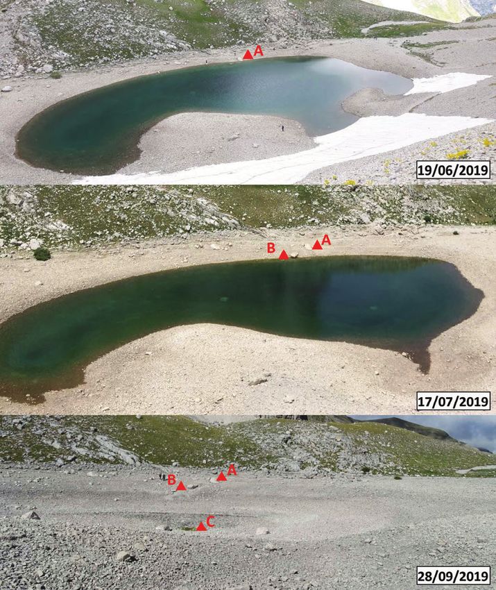
DOI 10.7343/as-2022-551 Acque Sotterranee - Italian Journal of Groundwater 2022-AS40-551: 27 - 35
Introduction of summer period in the last years.
Mountain regions are of special importance for global Multidisciplinary survey activities were conducted since
environmental and climate change research. Due to the 2018 in order to evaluate the effects induced on the Pilato
strong altitudinal gradients, many mountain areas provide Lake GDE by the Central Italy 2016-2017 seismic sequence
unique opportunities to detect and analyse global change (Martarelli et al. 2019). In fact, the site has been hit by the
processes and phenomena (Becker and Bugmann 2001). In earthquakes of the cited seismic sequence, but rockfall
this context, mountain lakes are often located in protected landslides from slopes were observed as the only local manifest
natural areas, a feature that leads to their role as guards of seismic-induced effect. Geomorphological evidence of surface
global environmental change. Despite variations in latitude, faulting was not observed in the lake area, while on the external
mountain lakes share many features, including their location western side of the Mt Vettore range there is a faulting surface
in catchments with steep topographic gradients, cold recognizable as the cropping out evidence of the fault system
temperatures, high incident solar and ultraviolet radiation, of Mt Vettore - Mt Bove (Testa et al. 2019), which has been
and prolonged ice and snow cover (Moser et al. 2019). inferred as responsible for the main shock of the cited seismic
Mountain lakes are usually relatively small, located in events (Gori et al. 2018). Thus, the study site is within the
sparsely vegetated catchments and exposed to extreme epicentral area of the 2016-2017 seismic sequence.
climates. Most of them are of glacial origin and range from The importance of hydrogeological surveys for the
a few samples in small mountain regions to many thousands characterization of GDEs and for raising the awareness on
in Arctic and sub-Arctic lands. These lakes are not relevant environmental and climate change impacts on such kind of
from the water reserve point of view, due to their usual GDEs was experienced and pointed out.
limited water volume and small hydrographic catchments
with respect to lake volume. They tend to be sometimes
in correspondence of headwaters, far from populated areas,
experiencing minimal or no direct human impact in their
catchments (Catalán et al. 2009).
Several studies have shown that groundwater can play an
important role in the water balances of such lakes (Hauer
et al. 1997; Hayashi and Rosenberry 2002; Barnett et al.
2005). However, a number of uncertainties remain, including
whether substantial groundwater exchange is common or
rare, what types of interactions may occur, and what are
the important factors affecting groundwater exchange. This
understanding is important for predictions of hydrology,
water chemistry and ecology patterns and interactions in the
headwaters of mountain watersheds (Roy and Hayashi 2008).
Lakes in mountainous areas are of special interest in
environmental studies. Mountain areas often have rocky
bedrock, with thin soils and sparse vegetation, which
together give rise to surface water with low ionic strength.
Such waters are particularly sensitive to inputs of atmospheric
pollutants and to changes in climate. Mountain lakes are in
general much less influenced by disturbance by local pollution
from agriculture and wastewater. Therefore, they are good
early warning indicators for monitoring more widespread
environmental changes (Brit and Wright 1998).
Located at an altitude of about 1950 meters in a glacial
cirque of Mount Vettore (Monti Sibillini National Park
- Central Italy), Pilato Lake is one of the few glacial lakes
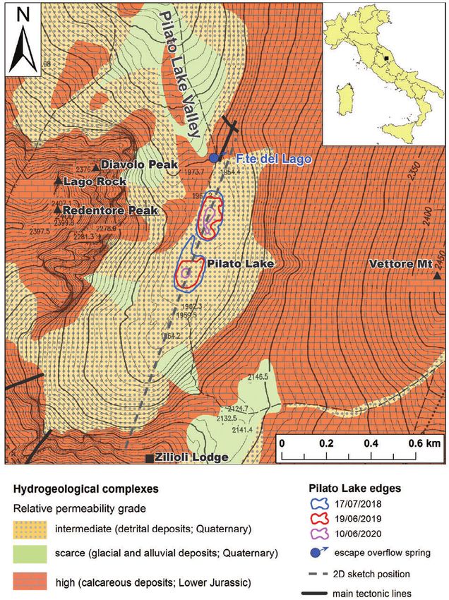
existing in the Apennines. Due to the endemic presence of the Fig. 1 - Hydrogeological simplified sketch map of the Pilato Lake area (modified from
Martarelli et al. 2019). The location of 2D hydrogeological sketch (reported in Fig. 4)
crustaceous Chirocephalus marchesonii (Ruffo and Visentini is here shown. Inset map shows study area location in the Italian context. Geographical
1957), the Pilato Lake (Fig. 1) was in the past mainly coordinates of the NW and SE edges of the figure are lat.42.830°, long.17.253° and
studied from the biological viewpoint, but hydrogeological lat.42.817°, long.13.275°, respectively.
information on the area of this groundwater dependent Fig. 1 - Carta idrogeologica semplificata dell’area del Lago di Pilato (modificato
da Martarelli et al. 2019). È qui riportata anche la traccia dello schema 2D di
ecosystem (GDE) was never collected before Martarelli et al.
Figura 4. Nell’inserto a piccola scala è inoltre indicata l’ubicazione dell’area
2019. The ongoing activities presented in this work are aimed di studio nell’ambito del territorio italiano. Le coordinate geografiche degli
to contribute to fill this gap and to evaluate the causes for the spigoli NW e SE della figura sono, rispettivamente, lat.42.830°, long.17.253°
more frequent occurrences of drying out of the lake at the end e lat.42.817°, long.13.275°.
28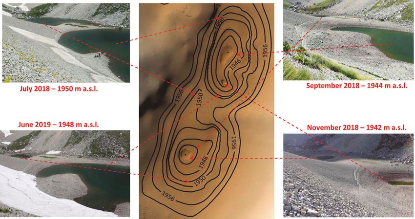
Acque Sotterranee - Italian Journal of Groundwater 2022-AS40-551: 27 - 35                                             DOI 10.7343/as-2022-551

Geological, structural and hydrogeological settings                            the lake’s waters (temperature; specific electrical conductivity,
   The Sibillini Mts area is in the central sector of the Apennine             EC; pH; obtained in situ by a multi-parametric analysis device).
Belt and consists of a Meso-Cenozoic thrust and fold structure                    Climatic characterization by analysis of available
formed during Upper Miocene-Quaternary. It is composed                         meteoclimatic long-term datasets (from 2002 to 2020) at
of a Triassic-Miocene pre-orogenic sedimentary succession                      selected stations located at Montemonaco, Monte Prata and
thrust on Mio-Pliocene syn-orogenic sediments featured                         Monte Bove Sud (precipitation - also snow, at the stations
by variable facies typologies and thickness values. The pre-                   equipped with snow-gauges - and temperature; data after
orogenic succession occurring in the study area is included                    Regione Marche 2021) and estimation of water loss through
in the Umbro-Marchean Apennine and is characterized by a                       evaporation from lake surface (according to Visentini 1937;
marine carbonate shelf domain of Lower Jurassic age thrust                     Dragoni and Valigi 1994) were performed. Among the former
on Middle Liassic-Lower Miocene stratified marine pelagic                      meteoclimatic stations, Monte Prata is the best representing
sediments (2500-3000 m of total thickness) (Boni et al. 2010;                  station with respect to Pilato Lake area geo-orographical
Pierantoni et al. 2013; Viaroli et al. 2021).                                  features (e.g., site elevation and exposition). Unfortunately,
   As concerns the groundwater resource scenario, the Sibillini                the meteoric annual mean precipitation data calculated at
Mts fissured and subordinately karstified carbonate ridge hosts                Monte Prata station (but the same is for other local stations
main aquifers feeding perennial springs having, in general, a                  located at high elevation) appear to be underestimated (about
constant flow rate and located at the margins of those aquifers                900 mm/yr) when compared with the realistic expected
(e.g., Amoruso et al. 2014; Fiorillo et al. 2015; Fronzi et al.                meteoric precipitation corresponding to its altitude and with
2020, Di Matteo et al. 2020). The Mio-Pliocene syn-orogenic                    respect to other local meteoclimatic stations distributed from
silico-clastic sediments act as an aquitard (Petitta et al. 2011;              about 400 to 1400 m a.s.l.. This is likely due to instrumental
Barberio et al. 2017; Petitta et al. 2018). The calcareous                     measurement errors induced by the heated rain gauges used
fissured and karstified lithotypes display a high effective                    in these stations for snowfall evaluation, which may cause up
infiltration grade (from 500 to 700 and up to 900 mm/yr)                       to 66% of unmeasured snow amounts, due to strong wind and
and in total feed a groundwater yield of about 300 m3/s (Boni                  other accidents during measurements (Lendvai et al. 2015). To
et al. 1986, 2010; Barberio et al. 2017; Petitta et al. 2018).                 obtain a whole rain and snow more realistic mean value at
   The complex tectonic processes occurred in the study area                   Pilato Lake area, the local elevation-precipitation correlation
induced the differentiation of the Sibillini Mts ridge in several              line was drawn on the basis of local meteoclimatic stations
hydrogeological units (Boni et al. 2010; Mastrorillo and                       data (the obtained reference equation is P=0.48·EL+790,
Petitta 2014; Fronzi et al. 2020; Nanni et al. 2020; Viaroli et                where P is precipitation and EL is elevation) and the local
al. 2021); in particular, the Pilato Lake area (Fig.1) has been                precipitation value was estimated (about 1700 mm/yr during
included within the Vettore-Sibilla-Castel Manardo Mts Unit.                   2017-2020). The accuracy problems with snowfall data are
According to the previously cited literature and to the outcomes               further emphasized when considering the monthly scale.
of the present study, the terrains cropping out in the Pilato                  Then, a combined discussion of air temperature (that are
Lake area may be grouped in the following hydrogeological                      featured by quite good time series) and precipitation data at
complexes (from bottom to top; Fig. 1): (i) basal calcareous                   monthly scale was considered as inappropriate. Furthermore,
complex, high relative permeability grade, Lower Jurassic,                     the Monte Prata station (data from 2002 to 2020) was selected
it hosts the Basal Calcareous Aquifer; (ii) alluvial deposit                   for carrying out a non-parametric Mann-Kendall test (Kendall
complex, scarce relative permeability grade, Quaternary; (iii)                 et al. 1983; Sneyers 1990), to evidence any possible statistical
glacial deposit complex, scarce relative permeability grade,                   trend only for air temperature time series.
Quaternary, it generally acts as an aquiclude/aquitard; (iv)                      Drone photogrammetry, obtained by Martarelli et al. 2019
detrital deposit complex, intermediate relative permeability                   using a Phantom 4 drone (according to Niedzielski 2019
grade, Quaternary, it may host subordinate aquifers.                           method) allowed the reconstruction of the bathymetry of the
   Detrital and glacial deposits constitute the sediments                      basin for water volume calculation.
sustaining the Pilato Lake ponds (Martarelli et al. 2019).                        Geophysical surveys performed by Martarelli et al.
                                                                               2019 consisted in active seismic surface-waves and ground
Methods                                                                        probing radar methods (according to Dal Moro 2015 and
  The survey methods used during the 2018-2020 monitoring                      Lin and Ashlok 2016 approach) and were finalized to subsoil
activities for verifying the effects induced by the Central Italy              characterization in terms of estimate of thickness of loose
2016-2017 seismic sequence on the Pilato Lake GDE (Martarelli                  debris deposits over the bedrock.
et al. 2019) are briefly described as follows. Hydrogeological                    Historical time series of the lake levels are not available.
surveys were performed for about two hydrological years                        Therefore, for investigating the lake drying out events
on monthly or bimonthly steps and included assessment                          occurred in the recent 2017, 2019 and 2020 summers, the lake
of variations of the lake level by lake edge differential GPS                  level lowering sequences during 2010, 2012 and 2014-2020
surveys (by a station equipped with a controller/receiver                      seasons were reconstructed by collection and interpretation
geosystem adopting rapid-static coordinate acquisition and                     of historical pictures available at different websites in the
post-processing methods) and chemical-physical parameters of                   internet. The water level positions taken from those pictures

                                                                                                                                           29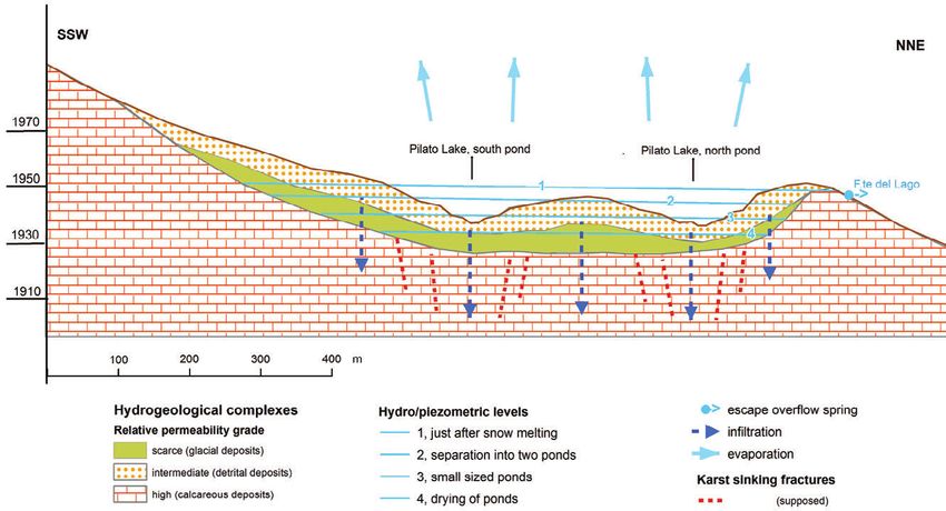
DOI 10.7343/as-2022-551                                                                        Acque Sotterranee - Italian Journal of Groundwater 2022-AS40-551: 27 - 35

                                                                                           were referred to the elevation values quoted according to
                                                                                           selected control points (Fig. 2). Yearly plots of these level
                                                                                           variations were obtained and discussed.
                                                                                             The bulk permeability (K) of sustaining sediments was
                                                                                           as well valuated by the application of equation K=ΔV/(A∙Δt),
                                                                                           considering the estimation with time (Δt) of wet lake surface
                                                                                           (A) and water lake volume variations (ΔV). The two latter
                                                                                           parameters were calculated using GIS spatial analyst tools
                                                                                           (DEM elaboration with 0.1 m resolution and volumetric and
                                                                                           area calculations), considering the performed reconstruction
                                                                                           of the bathymetry of the lake basin.

                                                                                           Results and discussion
                                                                                             Drone flight, elevation contour lines of topographic maps
                                                                                           and GPS surveys of elevation of lake borders with time allowed
                                                                                           a reconstruction of the lake basin bathymetry (Fig. 3) that
                                                                                           supported, in turn, the calculation of the sizes and volumes
                                                                                           of the water basin at different hydrological conditions and the
                                                                                           estimate of evaporation from the lake surface.
                                                                                             Geophysical surveys previously performed in the Pilato
                                                                                           Lake area (Martarelli et al. 2019) lead to infer a maximum
                                                                                           estimated thickness of debris deposits (detrital and glacial
                                                                                           sediments on top of calcareous bedrock is about 10-15 m in
                                                                                           correspondence of topographical highs and 25-30 m at the
Fig. 2 - Example of reconstruction of lake levels with time from pictures in different     middle points of minimum elevation of the two main ponds
dates of 2019. The lake level positions were referred to control points with quoted        featuring the lake bathymetry).
elevation values a.s.l. (red triangles marked with capital letters: A = 1947 m; B =          The physical-chemical characteristics of the lake waters
1946 m; C = 1940 m).
Fig. 2 - Esempio di ricostruzione dei livelli del lago nel tempo da foto scattate          are here reported as reference ranges (T=12-13°C, with a very
in differenti date del 2019. Le posizioni dei livelli del lago sono state riferite alle    marked seasonal variation; pH=8-9; EC=60-125 µS/cm) and
quote s.l.m. rilevate in alcuni punti di controllo (triangoli rossi contrassegnati
da lettere maiuscole: A = 1947 m; B = 1946 m; C = 1940 m).

Fig. 3 - Reconstruction of the Pilato Lake basin bathymetry (central picture) drawn by combined information obtained from drone flight, elevation contour lines of topographic maps
and GPS surveys of elevation of lake borders with time and implemented by DEM elaboration (resolution 0.1 m). Some lake pictures and the reference water level elevation a.s.l. are
also reported. In all pictures, the basin shown in the right-bottom corners is the northern pond of the Lake, while that in the left-top corners is the southern one.
Fig. 3 - Ricostruzione della batimetria del bacino del Lago di Pilato tracciata da informazioni comparate ottenute da volo di droni, traccia di isoipse di mappe
topografiche e rilievo GPS della quota del livello del lago nel tempo e realizzata tramite elaborazione di un DEM (risoluzione 0,1 m). Sono riportate anche alcune
foto del lago e le relative quote del livello idrico. In tutte le foto, il bacino visibile nell’angolo a destra in basso è la depressione settentrionale del lago, mentre il
bacino nell’angolo a sinistra in alto è quella meridionale.

30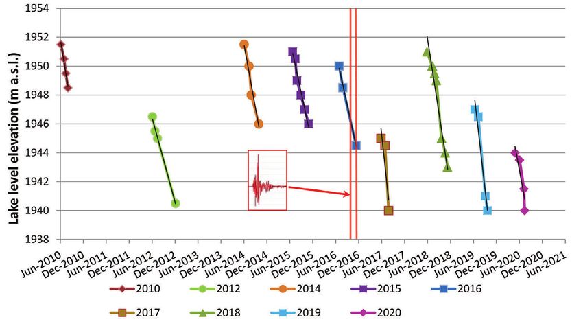
Acque Sotterranee - Italian Journal of Groundwater 2022-AS40-551: 27 - 35                                                        DOI 10.7343/as-2022-551

                                                                                                                 Fig. 4 - 2D sketch of the hydrogeological asset
                                                                                                                 of the Pilato Lake area (modified from Martarelli
                                                                                                                 et al. 2019). Thickness of detrital and glacial
                                                                                                                 deposits (about 15-25 m in total) and hydro/
                                                                                                                 piezometric level variations (about 20 m in total
                                                                                                                 from 1. to 4. position) are shown. Sketch location
                                                                                                                 is displayed in Figure 1.

                                                                                                                 Fig. 4 - Schema idrogeologico 2D dell’area
                                                                                                                 del Lago di Pilato (modificato da Martarelli
                                                                                                                 et al. 2019). Gli spessori dei depositi detritici
                                                                                                                 e glaciali (circa 15-25 m in totale) e le
                                                                                                                 variazioni dei livelli idro/piezometrici (circa
                                                                                                                 20 m in totale dalla posizione 1. alla 4.)
                                                                                                                 sono stati riportati. La traccia dello schema è
                                                                                                                 presente in Figura 1.

are consistent with those of stagnant and slightly oxygenated                    The persistence of the snowpack, especially in the spring
waters during summer-autumn low water conditions (during                       and early-summer seasons, ensures a continuous recharge of
the winter-spring season it is not possible to approach the                    the lake’s waters which assures that the waters do not drain
lake due to presence of snow and related avalanche hazard)                     completely at the end of the summer season. Therefore, this
and with prevailing provenance of the lake’s recharge by snow                  circumstance is crucial to avoid the complete disappearance of
melting and precipitation (Martarelli et al. 2019). A complete                 the lake (Martarelli et al. 2019). The mean air temperatures in
dataset of these data will be available in the future.                         the years 2017, 2019 and 2020 (about 7 °C) were higher than
   The surveys of the lake margins evidenced that the                          the annual mean value (about 6°C) and the highest within
maximum potential lake water levels, when the lake basin is                    the 2002-2020 period (Fig. 5), thus likely leading to early
potentially totally filled after the complete melting of snow,                 melting of the snowpack and a high evaporation rate from
is about 1960 m a.s.l. Furthermore, the minimum value of                       the lake surface, both contributing to the complete drainage
elevation of the lake bathymetry is about 1940 m a.s.l.. In                    of Pilato Lake.
particularly dry years, as occurred in 2017, 2019 and 2020,                      More in detail, the air temperatures during 2017-2020
the two ponds in which the lake separated in late summer                       (mean value within these four years is about 7°C) and their
dried out (Fig. 4; Martarelli et al. 2019).                                    effects on evaporation from the lake (E, range of values
   The whole of the surveyed hydrogeological results achieved                  obtained for the former four years is about 910-1080 mm/yr;
in this research and in a related previous study (Martarelli                   Visentini 1937 method; annual base equation E=90·Ta+300,
et al. 2019) allowed confirming the reconstruction of the                      for elevations >500 m a.s.l.) and on actual evapotranspiration
hydrogeological conceptual model for the Pilato Lake area                      (ET, corresponding range of values is about 450-480 mm/yr;
(Fig. 4). The initial water overflow through the Fonte del Lago                Turc 1961 method) were estimated. Finally, the mean value
spring (elevation about 1948 m a.s.l.), the evaporation from
the lake surface and the drainage process through the scarce
permeability glacial deposits towards the Basal Calcareous
Aquifer hosted at lower elevations within the calcareous
deposits are responsible for the progressive lowering of the
lake level.
   On the other side, as concerns the refilling process of the
lake, the hydrogeological conceptual model of the study area
showed that the stock up of lake water is driven by snow and
rain precipitations (P; annual estimated average is 1700 mm/
yr). From the meteoclimatic point of view, the non-parametric
Mann-Kendall test (Kendall et al. 1983; Sneyers 1990) carried
out on the mean air temperature time series of the Monte
                                                                               Fig. 5 - Plot of mean air temperature with time at the Monte Prata meteoclimatic
Prata gauging station evidenced major trends of general time                   station. Annual mean temperature and annual mean temperature trend are also shown.
tendency to temperature increase in February (trend value of                   In 2017, 2019 and 2020, the mean temperatures were the highest among the values
Mann-Kendall Test Z = 2.05; Sen’s slope estimate = 0.213),                     calculated during 2002-2020.
April (Test Z = 2.05; Sen’s slope = 0.151) and August (Test Z                  Fig. 5 - Diagramma delle temperature medie dell’aria rispetto al tempo nella
= 1.89; Sen’s slope = 0.161), also shown on the annual mean                    stazione meteoclimatica di Monte Prata. Sono state anche riportate la media
                                                                               annua delle temperature ed il trend delle temperature medie. Negli anni 2017,
temperature values (Test Z = 2.38; Sen’s slope = 0.060), as is                 2019 e 2020 le temperature medie sono state le più elevate tra i valori calcolati
evidenced by the regression line in Fig. 5.                                    nel periodo 2002-2020.

                                                                                                                                                            31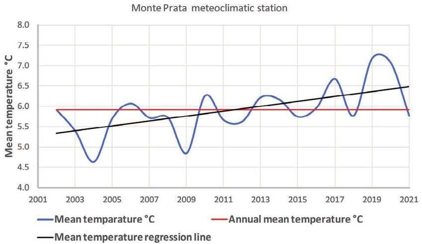
DOI 10.7343/as-2022-551                                                                       Acque Sotterranee - Italian Journal of Groundwater 2022-AS40-551: 27 - 35

of infiltration (I) through sustaining sediments within the                               Tab. 3 - Yearly values of regression line slope of lake level lowering measurements (see
same period was calculated using the hydrogeological budget                               Fig. 6).
equation I=P-R-ET-E and, considering the former estimated                                 Tab. 3 - Valori annuali della pendenza della retta di regressione dei livelli del lago
                                                                                          (vedi Fig. 6).
values and the negligible runoff value (R; e.g. Boni et al.
1986) in the relatively permeable calcareous deposits around                                                                    Reference
                                                                                             Year         Slope      R2                                     Statistics
the lake area, it resulted in a range of values obtained for the                                                                period
former four years of about 140-340 mm/yr (Tab. 1).                                           2010        -0.054      0.985      Jun-Aug               Period 2010-2016
  The contours of bathymetric isolines of the lake area,                                     2012        -0.032      0.997      Jun-Dec           mean         min         max
Tab. 1 - Range of values of the parameters of hydrogeological budget in the Pilato Lake      2014        -0.048      0.954      Jun-Oct          -0.044       -0.054      -0.032
GDE area within the 2017-2020 period.                                                        2015        -0.040      0.971      Jun-Nov
Tab. 1 - Intervallo dei valori degli elementi del bilancio idrogeologico nell’area           2016        -0.045      0.999      Jul-Nov
del GDE del Lago di Pilato nel periodo 2017-2020.

                         Parameter                               Value (mm/yr)               2017        -0.081      0.802      Jun-Aug               Period 2017-2021
 Rainfall and snowfall                         (P)                     1700                  2018        -0.057      0.957      Jun-Nov           mean         min         max
 Evaporation                                                                                 2019        -0.073      0.965      Jun-Sep          -0.066       -0.081      -0.051
                                                                    910÷1080
 (Visentini method)                           (E)
                                                                                            2020         -0.051      0.879      May-Jul
 Actual evapotranspiration [1]
                                                                    450÷480
 (Turc method)                                (ET)
 Runoff                                        (R)                  negligible            This is also true for the 2018, year with relatively abundant
                                                                                          precipitation and moderate temperature, demonstrating that
 Net effective infiltration                 (I=P-E-ET-R)             140÷340
                                                                                          the only meteoclimatic issues may not fully explain the
 [1] Mean temperature within the 2017-2020 period is about 7°C                            process. Probably, the acquisition of data in the next years
obtained by drone flights, elevation contour lines of                                     may be crucial for improving the understanding of the process
topographic maps and monthly/bimonthly GPS surveys of                                     itself. The quite insignificant overlapping of minimum and
elevation of lake borders were recently refined and allowed                               maximum ranges of slope values for both the 2010-2016
the estimation with time (Δt) of lake wet surface (A) and lake                            and 2017-2020 periods and the good R2 coefficient values
volume variations (ΔV), and then bulk permeability (K=ΔV/                                 of regression lines (varying from 0.802 and 0.999) support
A∙Δt) of sustaining sediments was as well valuated (10-6÷10-7                             the previous reported considerations (Tab. 3). It is then likely
m/s; Tab. 2). This is substantially in accordance with a grain                            that seismic quaking induced increasing permeability and,
size lab test carried out within the present study on a sample                            consequently, infiltration velocity through the lake sustaining
of the sediment beneath the lake. The test certified that the                             surficial (detrital and glacial) and/or bedrock deposits towards
terrain is gravelly-silty sand (sand 44.5%, gravel 25.8%, silt                            the subsurface. More frequent summer dryings of the lake
25.5, clay 4.2%), then likely ascribable to a similar expected                            are then conceivable for next years. After an accurate reading
permeability value range (e.g. Tomlinson 2015).                                           of Fig. 6 it is also possible to stress that a lake level elevation
   During the surveys at the Pilato Lake area, geomorphological                           value lower than about 1947 m a.s.l. on the May-June period
                                                                                          of each reference year represents a warning threshold for a
Tab. 2 - Evaluation of bulk permeability of Pilato Lake sustaining sediments.             probable late summer drying of the lake.
Tab. 2 - Stima della permeabilità d’insieme dei sedimenti che sostengono il
Lago di Pilato.
                                                                                          Conclusions
                   Parameter                               Value (mm/yr)
                                                                                            The research activities are still in progress and to date we
  Lake volume variations             (ΔV)               17.000-37.000 m3
                                                                                          can propose the results of this new step of discussion.
  Reference lake wet surface          (A)               10.000-28.000 m2                    The lake level from its maximum flooded elevation in May-
                                                            50-70 days                    June (completion of snow melting; the maximum potential
  Time span                            (Δt)
                                                     (4.320.000-6.048.000 s)              morphological level at 1960 m a.s.l.) fell down with time due
  Bulk permeability           (K=ΔV/(A∙Δt))            8.6∙10-7÷1.0∙10-7 m/s              to evaporation and infiltration through the glacial deposits in
                                                                                          the subsoil, reaching down a seasonal low level in late summer.
evidence of co-seismic ruptures was not observed, but only                                Finally, in particularly arid years, the lake may dry out (the
boulders detached from the surrounding slopes were found                                  minimum possible level at ponds bottom about 1940 m a.s.l.).
throughout the study area (Martarelli et al. 2019). In any                                  For investigating the lake drying in the recent 2017, 2019
case, for investigating the lake drying in the recent 2017,                               and 2020 summers, the seasonal lowering of lake levels
2019 and 2020 summers, the seasonal lowering of lake                                      during 2010, 2012 and 2014-2020 was reconstructed. It is
levels during 2010, 2012 and 2014-2020 was reconstructed                                  then supposed that seismic quaking induced an increase in
(Fig. 6). It resulted (Tab. 3) that in the pre-seismic years 2010-                        permeability and, consequently, infiltration velocity through
2016 the lake emptying was slower (mean value 0.044 m/d)                                  the lake sustaining detrital and glacial and/or bedrock deposits
than in the post-seismic time 2017-2020 (mean 0.066 m/d).                                 towards the subsurface. More frequent summer dryings of the

32
Acque Sotterranee - Italian Journal of Groundwater 2022-AS40-551: 27 - 35 DOI 10.7343/as-2022-551
Fig. 6 - Yearly lake level lowering during 2010, 2012 and 2014-2020. The regression line equations of each annual series are shown. A lake level elevation value lower than
about 1947 m a.s.l. on the May-June period of each reference year represents a warning threshold for a probable late summer drying of the lake. The vertical red lines represent the
main events of the 2016 seismic sequence.
Fig. 6 - Diminuzione dei livelli del lago negli anni 2010, 2012 e 2014-2020. Sono riportate le equazioni delle rette di regressione di ciascuna serie annuale.
Quote del livello del lago minori di circa 1947 m s.l.m. nei mesi di maggio-giugno di ogni anno di riferimento rappresentano il livello di allerta per il probabile
essiccamento del lago durante la stagione estiva. Le linee rosse verticali rappresentano i principali eventi della sequenza sismica 2016.
lake are then conceivable in next years. A lake level elevation Competing interest
value lower than about 1947 m a.s.l. on May-June period of The authors declare no competing interest.
each reference year represents a warning threshold for the
Acknowledgements
probable late summer drying of the lake.
The Ente Parco Nazionale dei Monti Sibillini is warmly thanked for the
Further investigation in the study area will include: support and provided authorization to field surveys at the Pilato Lake.
i) installation of data-loggers for surveying over time water Two anonymous referees are kindly acknowledged for their useful
levels in the two ponds of the lake, ii) in depth analyses of long- comments and suggestions.
term meteoclimatic data and estimate of evaporation from
the lake surface, iii) a more detailed drone photogrammetric Author contributions
survey, iv) a more accurate calculation of the hydrogeological All authors contributed to data collection, data processing, results
budget of the Pilato Lake basin, v) the implementation of a interpretation, writing, review and editing of the manuscript. All
authors have read and agreed to the published version of the manuscript.
numerical model.
Even if at a preliminary stage, the activities presented in
Additional information
this work contributed not only to a better comprehension of Supplementary information is available for this paper at
the Pilato Lake GDE, but they could also be a contribution for https://doi.org/10.7343/as-2022-551
implementing the limited literature on the topic of mountain Reprint and permission information are available writing to
lakes and the knowledge of the hydrogeological processes acquesotterranee@anipapozzi.it
Publisher’s note Associazione Acque Sotterranee remains neutral with regard
involving them. to jurisdictional claims in published maps and institutional affiliations.
33DOI 10.7343/as-2022-551 Acque Sotterranee - Italian Journal of Groundwater 2022-AS40-551: 27 - 35
REFERENCES Hauer FR, Baron JS, Campbell DH, Fausch KD, Hostetler SW,
Amoruso A, Crescentini L, Martino S, Petitta M, Tallini M (2014) Leavesley GH, Leavitt PR, Mcknight DM, Stanford JA (1997)
Correlation between groundwater flow and deformation in the Assessment of climate change and freshwater ecosystems of the
fractured carbonate Gran Sasso aquifer (INFN underground Rocky Mountains, USA and Canada. Hydrological Processes
laboratories Central Italy). Water Resource Research 50(6):4858- 11:903-924.
4876. (https://doi.org/10.1002/2013wr014491) Hayashi M, Rosenberry DO (2002) Effects of ground water exchange
Barberio MD, Barbieri M, Billi A, Doglioni C, Petitta M (2017) on the hydrology and ecology of surface water. Ground Water
Hydrogeochemical changes before and during the 2016 Amatrice- 40(3):309-316.
Norcia seismic sequence (Central Italy). Scientific Reports 7:11735. Kendall M, Stuart A, Ord JK (1983) The advanced theory of statistics.
https://doi.org/10.1038/s41598-017-11990-811735. Volume 3, Charles Griffin and Company, London.
Barnett TP, Adam JC, Lettenmaier DP. 2005. Potential impacts of a Lendvai A, Ranzi R, Peretti G, Berbenni F, Praolini A, Urbani S (2015)
warning climate on water availability in snow-dominated regions, Misura delle precipitazioni nevose mediante i pluviometri. Stima
Nature 438(17):303-309. degli errori sistematici e correzione delle serie storiche “Snowfall
Becker A, Bugmann H (2001) Global change and mountain regions— measurements by rain gauges. Systematic errors estimation and time
an IGBP initiative for collaborative research. In Global Change and series corrections”. Neve e Valanghe, Rivista AINEVA 84:12-21.
Protected Areas (pp. 3-9). Springer, Dordrecht. Lin S, Ashlock JC (2016) Surface-wave testing of soil sites using
Boni C, Baldoni T, Banzato F, Cascone D, Petitta M (2010) multichannel simulation with one-receiver. Soil Dynamics and
Hydrogeological study for identification, characterization and Earthquake Engineering 87:82-92. https://doi.org/10.1016/j.
management of groundwater resources in the Sibillini Mountains soildyn.2016.04.013
National Park (central Italy). Italian Journal of Engineering Martarelli L, Gafà RM, Guarino PM, Monti GM, Puzzilli LM, Silvi A
Geology and Environment 2:21-39. (https://doi.org/10.4408/ (2019) The Pilato Lake (Sibillini Mts., Central Italy): first results of
ijege.2010-02.o-02) a study on the supposed variations of its hydrogeological conditions
Boni C, Bono P, Capelli G (1986) Schema idrogeologico dell’Italia induced by the seismic sequence 2016-2017. Italian Journal of
Centrale “Hydrogeological Sketch Map of Central Italy”. Memorie Groundwater 8(4):7-12.
Società Geologica d’Italia 35:991-1012. Mastrorillo L, Petitta M (2014) Hydrogeological conceptual model of
Brit LS, Wright RF (1998) Mountain Lakes; Sensitivity to Acid the upper Chienti river basin aquifers (Umbria-Marche Apennines).
Deposition and Global Climate Change. Ambio 27(4), 280–286. Italian Journal of Geoscience 133(3):396–408. https://doi.
http://www.jstor.org/stable/4314736. org/10.3301/IJG.2014.12
Catalán J, Curtis CJ, Kernan M (2009) Remote European mountain Moser KA, Baron JS, Brahney J, Oleksy IA, Saros JE, Hundey EJ, Sadro
lake ecosystems: regionalisation and ecological status. Freshwater S, Kopáček J, Sommaruga R, Kainz MJ, Strecker AL, Chandra S,
Biology 54(12):2419-2432. Walters DM, Preston DL, Michelutti N, Lepori F, Spaulding SA,
Dal Moro G (2015) Surface Wave Analysis for Near Surface Christianson KR, Melack JM, Smol JP (2019) Mountain lakes: Eyes
Applications. Elsevier 244 pp. https://doi.org/10.1016/B978-0-12- on global environmental change. Global and Planetary Change
800770-9.18001-X 178:77-95.
Di Matteo L, Dragoni W, Azzaro S, Pauselli C, Porreca M, Bellina Nanni T, Vivalda PM, Palpacelli S, Marcellini M, Tazioli A (2020)
G, Cardaci W (2020) Effects of earthquakes on the discharge of Groundwater circulation and earthquake-related changes in
groundwater system: The case of the 2016 seismic sequence in the hydrogeological karst environments: a case study of the Sibillini
Central Apennines, Italy. Journal of Hydrology 583:124509. https:// Mountains (central Italy) involving artificial tracers. Hydrogeology
doi.org/10.1016/j.jhydrol.2019.124509 Journal 28:2409–2428. https://doi.org/10.1007/s10040-020-
Dragoni W, Valigi D (1994) Contributo alla stima dell’evaporazione 02207-w
dalle superfici liquide nell’Italia Centrale “Contribution to the Niedzielski T (Ed.) (2019) Application of Unmanned Aerial Vehicles in
estimate of the evaporation from the bodies of water of the Central Geosciences. Birkhauser Base, Springer 250 pp.
Italy”. Geologica Romana 30:151-158. Petitta M, Mastrorillo L, Preziosi E, Banzato F, Barberio MD, Billi
Fiorillo F, Petitta M, Preziosi E, Rusi S, Esposito L, Tallini M (2015) A, Cambi C, De Luca G, Di Carlo G, Di Curzio D, Di Salvo C,
Long-term trend and fluctuations of karst spring discharge in a Nanni T, Palpacelli S, Rusi S, Saroli M, Tallini M, Tazioli A,
Mediterranean area (central-southern Italy). Environmental Earth Valigi D, Vivalda P, Doglioni C (2018) Water-table and discharge
Sciences 74(1):153–172. https://doi.org/10.1007/s12665-014-3946-6 changes associated with the 2016–2017 seismic sequence in central
Fronzi D, Banzato F, Caliro S, Cambi C, Cardellini C, Checcucci R, Italy: hydrogeological data and a conceptual model for fractured
Mastrotrillo L, Mirabella F, Petitta M, Valigi D, Tazioli A (2020) carbonate aquifers. Hydrogeological Journal 26:1009-1026. https://
Preliminary results on the response of some springs of the Sibillini doi.org/10.1007/s10040-017-1717-7
Mountains area to the 2016-2017 seismic sequence. Italian Journal Petitta M, Primavera P, Tuccimei P, Aravena R (2011) Interaction
of Groundwater 9(1):19-25. https://doi.org/10.7343/as-2020-450 between deep and shallow groundwater systems in areas affected
Gori S, Falcucci E, Galadini F, Zimmaro P, Pizzi A, Kayen RE, Lingwall by quaternary tectonics (central Italy): a geochemical and isotope
BN, Moro M, Saroli M, Fubelli G, Di Domenica A, Stewart JP approach. Environmental Earth Science 63:11–30.
(2018) Surface Faulting Caused by the 2016 Central Italy Seismic Pierantoni P, Deiana G, Galdenzi S (2013) Stratigraphic and structural
Sequence: Field Mapping and LiDAR/UAV Imaging. Earthquake features of the Sibillini mountains (Umbria-Marche Apennines,
Spectra 34(4):1585-1610. doi:10.1193/111417EQS236MR Italy). Italian Journal of Geosciences 132(3):497-520.
34Acque Sotterranee - Italian Journal of Groundwater 2022-AS40-551: 27 - 35 DOI 10.7343/as-2022-551
Regione Marche (2021) Servizio di Protezione Civile - Sistema
Informativo Regionale Meteo-Idro-Pluviometrico “Marche Region
- Civil Protection Service - Meteo-Hydro-Pluviometric Regional
Information System”. https://www.regione.marche.it/Regione-
Utile/Protezione-Civile/Progetti-e-Pubblicazioni/Meteo. Visited
May 2021.
Roy JW, Hayashi M (2008) Groundwater exchange with two small
alpine lakes in the Canadian Rockies. Hydrological Processes
22:2838-2846. https://doi.org/10.1002/hyp.6995
Ruffo S, Visentini G (1957) Una nuova specie di Fillopode Anostraco
dei Monti Sibillini (Chirocephalus marchesonii n. sp.) “A new
species of Anostracus Phillopod of the Sibillini Mts (Chirocephalus
marchesonii n. sp.)”. Memorie Museo Civico di Storia Naturale,
Verona 6:1-8
Sneyers R (1990) On the statistical analysis of series of observations.
Technical Note N.143, World Meteorological Organization,
Geneva, Switzerland.
Testa A, Boncio P, Di Donato M, Mataloni G, Brozzetti F, Cirillo D
(2019) Mapping the geology of the 2016 Central Italy earthquake
fault (Mt. Vettore–Mt. Bove fault, Sibillini Mts.): geological details
on the Cupi-Ussita and Mt. Bove-Mt. Porche segments and overall
pattern of coseismic surface faulting. Geological Field Trips and
Maps 11. ISSN:2038-4947 (http://gftm.socgeol.it/)
Tomlinson MJ (2015) Swiss Standard SN 670 010b: Characteristic
Coefficient of Soils. Association of Swiss Road and Traffic Engineers,
Zurich. In: Foundation Design and Construction, 7th edn, Pitman,
London.
Turc L (1961) Estimation of irrigation water requirements, potential
evapotranspiration: a simple climate formula evolved up to date.
Annual of Agronomy 12:13-49.
Viaroli S, Mirabella F, Mastrorillo L, Angelini S, Valigi D (2021)
Fractured carbonate aquifers of Sibillini Mts. (Central Italy).
Journal of Maps 17(2):140-149.
Visentini M (1937) L’evaporazione dagli specchi liquidi “The
evaporation from bodies of water”. Memorie e Studi Idrografici.
Servizio Idrografico, Publication N.2, Istituto Poligrafico dello
Stato, 9, Rome.
35You can also read


