More than heavy rain turning into fast-flowing water - a landscape perspective on the 2021 Eifel floods - NHESS
←
→
Page content transcription
If your browser does not render page correctly, please read the page content below
Nat. Hazards Earth Syst. Sci., 22, 1845–1856, 2022
https://doi.org/10.5194/nhess-22-1845-2022
© Author(s) 2022. This work is distributed under
the Creative Commons Attribution 4.0 License.

More than heavy rain turning into fast-flowing water
– a landscape perspective on the 2021 Eifel floods
Michael Dietze1,2 , Rainer Bell3 , Ugur Ozturk4,5 , Kristen L. Cook5 , Christoff Andermann1 , Alexander R. Beer6 ,
Bodo Damm7 , Ana Lucia6 , Felix S. Fauer8 , Katrin M. Nissen8 , Tobias Sieg4 , and Annegret H. Thieken4
1 Section  4.6 Geomorphology, GFZ German Research Centre for Geosciences,
Telegrafenberg F427, 14473 Potsdam, Germany
2 Faculty of Geoscience and Geography, University of Göttingen,

Goldschmidtstraße 5, 37077 Göttingen, Germany
3 Department of Geography, University of Bonn, Meckenheimer Allee 166, 53115 Bonn, Germany
4 Institute of Environmental Science and Geography, University of Potsdam,

Karl-Liebknecht-Str. 24–25, 14476 Potsdam, Germany
5 Section 2.6 Seismic Hazard and Risk Dynamics, GFZ German Research Centre for Geosciences,

Telegrafenberg F427, 14473 Potsdam, Germany
6 Department of Geosciences, University of Tübingen, Schnarrenbergstr. 94–96, 72076 Tübingen, Germany
7 Department II – Applied Physical Geography, University of Vechta, Universitätsstraße 5, 49377 Vechta, Germany
8 Institute of Meteorology, Freie Universität Berlin, Carl-Heinrich-Becker-Weg 6–10, 12165 Berlin, Germany

Correspondence: Michael Dietze (mdietze@gfz-potsdam.de)

Received: 16 February 2022 – Discussion started: 18 February 2022
Revised: 24 April 2022 – Accepted: 27 April 2022 – Published: 2 June 2022

Abstract. Rapidly evolving floods are rare but powerful           land use, and emerging process connections and feedbacks as
drivers of landscape reorganisation that have severe and long-    critical non-hydrological dimensions of the flood. With this
lasting impacts on both the functions of a landscape’s sub-       landscape scale perspective, we develop requirements for im-
systems and the affected society. The July 2021 flood that        proved future event anticipation, mitigation, and fundamental
particularly hit several river catchments of the Eifel region     system understanding.
in western Germany and Belgium was a drastic example.
While media and scientists highlighted the meteorological
and hydrological aspects of this flood, it was not just the
rising water levels in the main valleys that posed a hazard,      1   Introduction
caused damage, and drove environmental reorganisation. In-
stead, the concurrent coupling of landscape elements and the      The 14–15 July 2021 flood in western Germany as well as
wood, sediment, and debris carried by the fast-flowing wa-        parts of Belgium and the Netherlands revealed the unpre-
ter made this flood so devastating and difficult to predict.      paredness of societies, policymakers, and scientists across
Because more intense floods are able to interact with more        many dimensions. The anticipated precipitation amounts had
landscape components, they at times reveal rare non-linear        been communicated several days ahead; hydrological mod-
feedbacks, which may be hidden during smaller events due          els and numerous stream gauges were in place; and informa-
to their high thresholds of initiation. Here, we briefly review   tion chains and authority responsibilities were implemented.
the boundary conditions of the 14–15 July 2021 flood and          Yet the flood, which hit several catchments that originate
discuss the emerging features that made this event differ-        in the Eifel (Fig 1), developed into a massive hazard event
ent from previous floods. We identify hillslope processes, as-    that propagated downstream for long distances and persisted
pects of debris mobilisation, the legacy of sustained human       for many hours. Meanwhile, and evident from media reports
                                                                  focussing on the preceding rain event and the evolution of

Published by Copernicus Publications on behalf of the European Geosciences Union.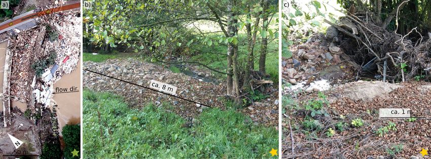
1846                                                                                                M. Dietze et al.: Eifel floods

the flood, mitigation efforts remained insufficient; the ac-       susceptibility to gravitational mass movement in this land-
tual flood wave was underpredicted; and emergency activi-          scape, except for steep landforms that predominantly result
ties failed to prevent a disaster that led to 184 fatalities and   from man-made construction (e.g. road escarpments, waste
2 missing persons (as of 24 November 2021) in Germany              dumps, open-pit mining; cf. Fig 1). Both regions hold a long
alone (Thieken et al., 2021). This unexpectedly high toll is       legacy of human land use.
the highest in Germany for the past 6 decades.                        Although the official data collection on economic flood
   The meteorological driver of the crisis was a cyclone           impacts in Germany’s federal states of North Rhine-
named “Bernd” (Schneider and Gebauer, 2021). It travelled          Westphalia and Rhineland-Palatinate is ongoing; current es-
from the North Atlantic via France towards central Europe.         timates point to EUR 33 billion in damage to private house-
Over western Germany, its propagation speed was slowed             holds, infrastructure, forestry, and agriculture as well as viti-
down by an anticyclone over eastern Europe, causing al-            culture enterprises (Fekete and Sandholz, 2021). In Germany,
most stationary precipitation over the Eifel region from 12        the Ahr valley was hit hardest: 62 out of 75 bridges were de-
to 15 July, releasing 115 mm rain in 72 h on average in            stroyed, and almost all wineries were heavily affected (BMI,
for example the Ahr catchment (Junghänel et al., 2021),            2021). In Rhineland-Palatinate at least 65 000 people were
with a maximum value of 157 mm on 14 July at the DWD               directly affected by the event. A total of 135 people lost their
(Deutscher Wetterdienst) station Köln-Stammheim. The soils         lives; at least 766 people were injured; and 2 are still missing
in the entire region were already mostly saturated due to fre-     (Schmid-Johannsen et al., 2021). However, societal impacts
quent previous rain events, which is expressed by an average       occurred not only during the event itself. Months later, in-
free storage capacity < 70 mm within the soils’ top 60 cm as       ner cities remain severely damaged, and commercial and gas-
well as an average soil field capacity of 80 %–100 % (DWD-         tronomy businesses are still heavily disrupted. Their reopen-
Agrowetter, 2022). The meteorological situation was prop-          ing depends on the timely and simultaneous restoration of
erly forecasted days in advance by several weather predic-         key infrastructure like electricity, telecommunications, wa-
tion models (DWD, 2021; Schneider and Gebauer, 2021).              ter, and sewage. Disruption also affects schools and childcare
The discrepancy between the accuracy of the meteorological         facilities in some places, putting another burden on affected
forecasts and the shortcomings of flood hazard forecasting         families. Physiological illnesses as well as psychological im-
and communication reveals some of the challenges involved          pacts on people who lost their homes, relatives, and friends
in anticipating the impacts of extreme events.                     during the flood represent a long-term legacy of the flood
   The next element of the evolutionary trajectory of the cri-     event beyond the areas actually impacted by the flood. For-
sis was the surface runoff of excess rainfall that was not able    mer floods in Germany revealed that a devastating experience
to infiltrate into the ground and hence triggered several non-     preoccupied affected people for years (Thieken et al., 2016).
linear processes, positive feedbacks, and process connections      Therefore, socio-psychological support is a key to recovery.
(Dietze and Ozturk, 2021). Altogether, these dynamics am-             Based on empirical field studies during, immediately af-
plified the impact of the flood on the landscape, particularly     ter, and over several weeks after the flood, we propose four
in the anthropogenic realm. To understand these dynamics,          critical non-hydraulic dimensions of flood-related processes.
it is necessary to first examine the different landscape ele-      We present examples for each of these dimensions and dis-
ments activated by the event and then to explore their modes       cuss consequences of their interaction. These representative
of interplay. The flood hit several European countries. In Ger-    case studies form the basis of our synthesis of requirements
many particularly, it impacted two geomorphically distinct         to improve mitigation efforts for future events.
regions: the Eifel with the Ahr valley to the south and the
Lower Rhine Bay with the Erft catchment to the north. The
Eifel is a typical low mountain range with steep, deeply in-       2   Method overview
cised valleys (see Fig. 1 for the slope signature). These val-
leys cut through numerous Paleozoic lithologies with varying       In this text, we decisively pursue a descriptive approach, fo-
degrees of fracturing, crack orientation, and ground perme-        cussing on generalised implications of systematic findings
ability, which impose a pronounced predisposition to grav-         during field mapping campaigns carried out early after the
itational mass movement (Damm et al., 2010). In general,           flood event. There are several reasons for this approach. The
hillslopes are covered by Pleistocene, 1–3 m thick periglacial     amount and quality of data during the flood, such as gauge
cover beds that are largely unstable due to the specific grain-    data, satellite imagery, and on-site instrumental data, are lim-
size distribution, sensitive to water supply, and frequently       ited due to abundant cloud cover. Likewise, post-flood re-
incorporated in landslides (Bell, 2007; Damm et al., 2013).        mote sensing data (BBK-DLR, 2022) is available for the
Rockfall-dominated cliffs are developed on steep slopes. In        main valley sections but not for headwater systems, where
contrast, the Lower Rhine Bay region including the Erft            the flood gained its momentum and non-linearity (Dietze and
catchment is an area of subsidence with smooth topogra-            Ozturk, 2021). Finally, model results that are currently pro-
phy, filled by highly permeable Cenozoic sediments with a          duced do not capture the non-hydrodynamic dimension of
widespread cover of Quaternary loess deposits. There is no         the flood, while high-resolution 3D terrain information, es-

Nat. Hazards Earth Syst. Sci., 22, 1845–1856, 2022                                 https://doi.org/10.5194/nhess-22-1845-2022
M. Dietze et al.: Eifel floods 1847
from months before the event (BBK-DLR, 2022). However,
the availability and format of the data (web service) only al-
lowed for non-quantified, descriptive studies.
Core information about the flood event is based on exten-
sive and multi-temporal field mapping campaigns through-
out the wider Eifel region, decisively including headwater
regions and their coupling with tributaries of the Ahr River.
Surveys of flood water marks, erosional features along chan-
nels and hillslopes, deposited sediment bodies caused by
ponding and hydrodynamic ejection of bed material, and
large woody debris accumulations were carried out 1 d after
the flood and repeatedly within 2–3 weeks and 2–4 months.
Surveys included the documentation of the type of feature
as denoted above, information on the location and size, and
a description of the geomorphic process regime responsible
for its creation. The material presented in this text is limited
to representative examples because a quantitative regionali-
sation needs to be based on post-event high-resolution terrain
information (see above).
3 Flood dimensions and emerging aspects
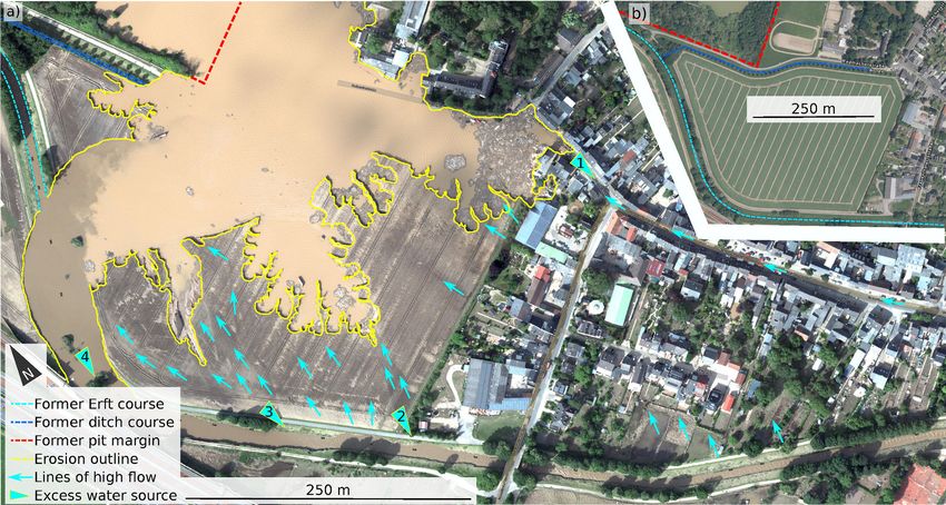
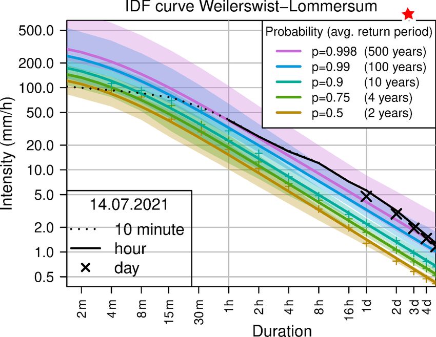
Figure 1. Map of the affected area with 3 d precipitation accumu- 3.1 Hydrometeorological dimension
lated for 12–15 July 2021 from RADOLAN data (Radargestützte
Niederschlagsanalyse und -vorhersage; CDC, 2022). Stars indicate According to Fig. 1 based on radar and station observa-
locations of pictures of other figures in this article. Light-blue lines tions (RADOLAN data set; Weigl and Winterrath, 2009) the
depict rivers of special interest mentioned in the text. Background precipitation amount for the 72 h period of 12–15 July at
map shows two of the most affected river systems, Erft and Ahr Weilerswist-Lommersum is similar to the amount observed
(line width indicating stream order), on top of a hillshade and slope in Blessem (Fig. 1). Moreover, the time series at the selected
map. Inset shows the location of the map within Germany. station is sufficiently long for the calculation of robust IDF
curves (daily precipitation is available since 1905, as well as
hourly precipitation since 2004). The analysis confirms the
unusual extreme character of the precipitation amounts dur-
sential for quantitative evaluation of erosion and deposition ing the July event (black lines and crosses in Fig. 2). Sub-
patterns, is currently still being produced (Bell et al., 2022; daily as well as daily and multi-day amounts exceeded the
Wenzel et al., 2022). values corresponding to a 500-year return period determined
Nevertheless, we are able to constrain the antecedent con- under the assumption of stationary climate conditions.
ditions; driver mechanisms; and, to some extent, the im-
pacts of the flood event based on instrumental data. Spa- 3.2 Hillslope dimension
tially resolved precipitation information (Weigl and Winter-
rath, 2009; CDC, 2022) such as 1 km2 gridded hourly data In typical scenarios, hillslope runoff delivers unconcentrated
is stacked as 72 h sums throughout the main event dura- Hortonian or saturation overland flow to the streams, where
tion (12–15 July 2021). In addition, instrumental station data discharge can accumulate and build up deeper and faster
(CDC, 2022) of representative sites were used to characterise hydrographs. For the July 2021 flood, during post-event
the severity of the rain event. We fitted intensity–duration– mapping campaigns we witnessed several occasions where
frequency (IDF) curves to historical annual maximum pre- ephemeral headwater drainages had turned into streams, con-
cipitation measurements. The IDF model was fitted with veying overland flow some decimetres deep (Fig. 3a). These
the extended consistent quantile estimation method (Fauer local phenomena allowed overland flow velocity to increase
et al., 2021) and evaluated for the DWD station Weilerswist- by 1 to 2 orders of magnitude (Dietze and Ozturk, 2021),
Lommersum (Fig. 2). which was further amplified by the effects of infrastructure
Flood-affected areas and the surface change due to erosion (see Sect. 2.3), such as forest tracks with rain ditches running
and deposition of sediment and large woody debris were in- alongside. While the tracks perpendicular to slope aspect
spected by analysing aerial RGB (red–green–blue) imagery. were extensive runoff collectors (evidenced by systematic
The material was collected 1 d after the flood and allowed high water marks throughout mapped regions), the ditches ef-
for a comparison of emerging surface features with imagery ficiently conveyed collected water to release spots that acted
https://doi.org/10.5194/nhess-22-1845-2022 Nat. Hazards Earth Syst. Sci., 22, 1845–1856, 2022
1848                                                                                                     M. Dietze et al.: Eifel floods

                                                                       able to enter a debris flow channel, ultimately triggering this
                                                                       mass-wasting process. In most cases there were ditch-lined
                                                                       roads that collected and delivered the water. In addition to ex-
                                                                       cess water, the investigated debris flows had at least one loca-
                                                                       tion in their contributing area that served as a massive source
                                                                       of mobile material. For example, the debris flow in Fig. 3c
                                                                       mobilised large amounts of material downstream of a 4–5 m
                                                                       high knickpoint, which formed by the overflow of a manu-
                                                                       factured forest track crossing the channel. This artificial dam
                                                                       had a 50 cm drainage tube that quickly got clogged, causing
                                                                       backfilling and finally overtopping by the flood water. The
                                                                       high energy release at the resulting waterfall base caused
                                                                       erosion of the surrounding slope sections and the channel
                                                                       bed, sourcing rock material and trees into the debris channel
                                                                       and then into the main channel, the Trierbach, downstream
                                                                       (Fig. 1). Evidently, there were several previous debris flow
                                                                       deposits visible in the eroded bank of the Trierbach, indicat-
Figure 2. IDF curve for the weather station Weilerswist-
                                                                       ing that the entering debris channel had been active several
Lommersum. Observations of 14 July precipitation are added in
black based on different measurement intervals. Coloured lines de-
                                                                       times in the past.
pict different non-exceedance probabilities; respective shadings in-      The landsliding component of hillslope material contribu-
dicate 90 % confidence intervals.                                      tion had a series of triggers, mechanisms, and time lags to
                                                                       the precipitation phase. Post-flood mapping revealed numer-
                                                                       ous shallow landslides that were not related to fluvial un-
as new gully heads (based on freshly developed erosional               dercutting as a trigger but were located on steep concave
features). Once such gullies had formed, it is physically plau-        slope sections, hence at preferentially wetter slope positions
sible that a positive feedback loop was implemented (Molina            (Giuseppe et al., 2021). This suggests that their activity was
et al., 2009; Anderson and Anderson, 2010), leading to in-             triggered by excess precipitation before and during the rain-
creasingly faster and more erosive discharge towards the val-          fall event. These features typically had a spatial extent of a
ley bottoms. Hence, during the flood, concurrent landscape             few to a few tens of metres and were in most cases not con-
reorganisation, namely gullying by a concentration of over-            nected to a channel. In contrast, there were also numerous
land flow amplified by infrastructure, most likely played a            river banks on the outer side of river bends that showed sig-
key role in changing the drainage efficiency. This spatial             nificant undercutting and, consequently, slope failures (Oz-
feedback is not accounted for in commonly applied hydraulic            turk et al., 2018). These well-connected landscape elements
models.                                                                were able to deliver sediment and woody debris directly
   Hillslopes contributed material not only through uncon-             to the channel (Fig. 4a). Such slope instabilities ranged in
centrated overland flow and focussed fluvial processes but             length from a few metres to features that have affected sig-
also via gravitational mass wasting, most importantly in the           nificant parts of valley hillslopes. In some cases, entire hill-
form of debris flows and shallow and deep-seated landslides.           slopes with older instabilities were undercut (Fig. 3d) and
During field mapping campaigns immediately after the event,            might become reactivated subsequently. One such example
we documented numerous debris flows emerging from hill-                of a river meander bend is depicted in Fig. 4b, where a 100 m
slopes. These debris flows altered the hillslopes by erosion of        long and 16 m high rock face was stripped of its debris apron
soil and vegetation and severely impacted the channels that            as the Ahr River level rose by about 5 m above the current
drain the valleys. They injected coarse particles and woody            water level (cf. the flood impact scar in Fig. 4b). Subsequent
debris into the channels, which had a series of consequences.          visits to the site revealed traces of slope movement, such as
In many cases, the channel thalweg was displaced, or the en-           extending cracks in a paved road crossing just above the rock
tire trunk river was relocated within the flood plain; the local       slope. It is unclear how increased soil moisture during the
gradient was changed; and in some cases the entire flow was            winter period (Dietze et al., 2020) will affect the transient
blocked at least temporarily (Fig. 3b). These abrupt changes           activity of this rock slide. Hence, further close monitoring of
have follow-on effects on channel morphology, for exam-                the slope instability is required to anticipate its failure and the
ple bed armouring due to sediment sizes exceeding transport            potential for subsequent blockage effects on the Ahr River.
capacity, and the excavation of the bed including bedrock
downstream, with enhanced capacity of future bedload trans-            3.3   Debris mobilisation
port and potential knickpoint migration upstream (Berger
et al., 2011; Hu et al., 2021). Most of the mapped debris              Large woody debris played a critical role in rendering the
flow source points were locations where excess water was               flood non-linear and difficult to predict, from small headwa-

Nat. Hazards Earth Syst. Sci., 22, 1845–1856, 2022                                     https://doi.org/10.5194/nhess-22-1845-2022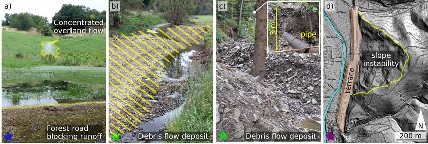
M. Dietze et al.: Eifel floods                                                                                                             1849

Figure 3. Landscape features emerging from the flood. For locations of these pictures, see star signatures in Fig. 1. (a) Focussed discharge
along the hillslope causing deep and fast flow and thus efficient drainage in the background. However, the provided water is not routed
downslope in the foreground but ponded by infrastructure and released at selected spots with increased erosive stream power. (b) Deposition
area of the debris flow shown in panel (c), injecting massive debris into the main channel (Trierbach), temporally blocking the stream and
causing severe reorganisation of the hydraulic geometry. (c) Lateral deposits of the debris flow at the end of the valley-confined section. Inset
shows upstream knickpoint formed by overspill and erosion of clogged drainage pipe (50 cm diameter). (d) Old slope instability (yellow line)
above a 20 m high engineered terrace with industrial infrastructure on it. The terrace just east of the town of Antweiler had been undercut by
the Ahr River during the flood.

ter channels down to the main streams. Tree logs could have                backwater effects (Fig. 5a). As a consequence, upstream wa-
been recruited from forest-covered hillslopes with abundant                ter levels rose, and the inundated areas grew until the obstacle
dead wood due to the drought years of 2018 to 2020 (van der                was either bypassed, overtopped, or destroyed. In the former
Wiel et al., 2021). However, apart from the linear erosive                 case, the bypass location experienced increased flow veloc-
features described in Sect. 2.2, there was limited field ev-               ity and thus bed shear stress, resulting in focussed erosion.
idence of systematic unconcentrated overland flow on hill-                 The latter effect has the potential to generate a pulse of wa-
slopes, and in no occasion did this point to potential flow                ter travelling downstream like an outburst flood. Given the
depths necessary to entrain logs (Baudrick and Grant, 2000)                presence of many such obstacles along the course of the Ahr
and route them through a maze of standing trees. The re-                   valley (62 out of 75 bridges destroyed) and most likely other
cruitment of large woody debris from riparian zones, where                 streams draining the Eifel, the failure of obstacles most likely
lateral erosion impacted former tree habitats (green line sig-             contributed to non-linear, pulsed hydrograph behaviour, as
nature in Fig. 3a), is thus much more likely. Aerial imagery               partly confirmed by affected people and experienced during
collected along main rivers 1 d after the flood (BBK-DLR,                  earlier floods (Roggenkamp and Herget, 2022). However, the
2022) shows substantial removal of trees along the Ahr River               large spacing, insufficient time resolution (15 min sampling
and other floodplains. Nevertheless, a quantitative survey of              interval), and eventual failure of existing stream gauges pre-
the dead-wood delivery capability of the forested hillslopes               vent us from resolving this conceptualised hydrograph be-
and riparian zones still needs to be conducted. Ideally, such              haviour and its resulting inundation and shear stress pulses.
a survey would be based on high-resolution point cloud data,               The traces of these clogs are visible both in the main val-
for example from dedicated airborne laser scan missions.                   leys (BBK-DLR, 2022) and in headwater regions, where we
Understanding the relative importance and pattern of differ-               were able to map numerous blockages of first-order streams,
ent sources of large woody debris is important not only for                either at anthropogenic structures (bridges, water passages,
restoration efforts in the flood-affected areas but also for mit-          fences) or at narrows formed by riparian trees (Fig. 5b). In
igating future flood hazards (Lucia et al., 2018). In a preven-            many reaches, these blockages were formed at a spacing of a
tive manner, especially given the likely increase in extreme               few tens of metres, ponding backwater due to accumulation
events (IPCC, 2021), the general impact of large woody de-                 of organic fine material (Schalko et al., 2018) and implying
bris on central European landscape dynamics and the suscep-                significant effects already at very small contributing areas.
tibility of different tree species should be investigated.                 The propagation of non-linear flow effects from small creeks
   The subsequent transport of large woody debris through                  to and throughout the trunk river of a catchment is a crucial
the river channels had a series of effects (Jochner et al., 2015;          step to take for successful future flood impact anticipation.
Okamoto et al., 2020). In the main streams, clogging of ob-                   A further important effect of large woody debris, espe-
stacles, mostly bridges, resulted in temporary ponding and                 cially in headwater regions, was the role in ejected coarse

https://doi.org/10.5194/nhess-22-1845-2022                                         Nat. Hazards Earth Syst. Sci., 22, 1845–1856, 2022
1850 M. Dietze et al.: Eifel floods
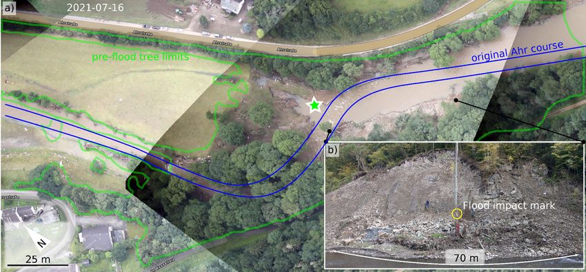
Figure 4. Debris mobilisation features in the Ahr valley near Müsch (cf. Fig. 1). Aerial image (BBK-DLR, 2022) taken 1 d after the flood.
The light-green outline depicts the tree limit before the flood. Blues lines illustrate the pre-flood course of the Ahr River. (b) View from the
green star in panel (a) towards the eroded right bank, which had activated a 16 m high rockslide (persons for scale). Note flood impact mark
on a remaining tree at 5 m above current water level. Please note that the date format used in this figure is year-month-day.
inorganic debris from the stream bed (Fig. 4b) onto the flood- observed systematic changes in fluvial erosion features along
plain. Also fine material was deposited in front of woody de- small headwater channels. Forest-covered floodplains with
bris obstacles (Fig. 5c) and clogged anthropogenic structures, strong erosional features were connected to virtually unaf-
such as bridges. This readily available fine material is now a fected grassland sections, and intact slopes suddenly showed
temporary source for increased fluvial sediment flux. Hence, linearly incised sections without a plausible contributing
even low-intensity floods will be able to carry comparably area. In most of these cases, however, we were able to iden-
high concentrations of sediment particles. In contrast, the tify artificial subsurface drainage systems, often visible as
ejected coarse bed particles are currently removed from the fragments of drainage pipes. Not surprisingly, according to
fluvial domain until future bank erosion (or human land use interviews with residents, systematic tile drainage is a com-
practice) reincorporates them to the channel. Debris also re- mon practice in the area to improve grassland quality or sim-
sulted in permanent alterations to stream courses, due to lat- ply to manage the wastewater of dispersed houses. The con-
eral and vertical erosion, and in some steep channel reaches sequences during the July flood were either an increased dis-
even led to incision into the underlying weathered bedrock as charge contribution where tile drainage remained intact or in-
mapped out systematically in headwater reaches. This again jection of excess water into the ground where drainage pipes
resulted in undercutting of the banks and local landslides. eventually filled up with debris and were clogged. In the for-
The spatial reorganisation of sediment in the fluvial domain mer case, the hydrological flashiness of the landscape in-
as well as overall changes in river geometry and bed proper- creased, while in the latter case the result was an elevated sus-
ties – from small creeks a few kilometres past the watershed ceptibility of hillslopes to failures and incision. Such failures
to major rivers like the Ahr – inevitably caused a transient in may be local effects, but the increased flashiness had an ex-
the catchment reaction to future floods. ternal effect by increasing the rapid build-up of flood waves
in subsequent channels. Since many of the tile drainage and
3.4 Anthropogenic dimension wastewater systems are several decades old and not necessar-
ily documented, including their effects in runoff models will
The flood happened in a cultural landscape with a long be a challenging though necessary future task.
legacy of human land use. Accordingly, there were typical Both regions, the Ahr valley and Lower Rhine Bay, hold a
primary effects of land use, particularly surface features on long legacy of human land use that influence the susceptibil-
flood dynamics such as an increased and accelerated sur- ity to gravitational mass movements. According to the Ger-
face runoff on cultivated hillslopes (Bronstert et al., 2020), man landslide database (Damm and Klose, 2015) the pro-
some of which are already mentioned above (e.g. Figs. 2a, nounced susceptibility to mass movements in the Ahr val-
4a; clogged structures, shallow landslides due to undercut, ley is exemplified by 49 database records from the middle
or oversteepened slopes). During our mapping campaign, we
Nat. Hazards Earth Syst. Sci., 22, 1845–1856, 2022 https://doi.org/10.5194/nhess-22-1845-2022M. Dietze et al.: Eifel floods 1851 Figure 5. Effects of large woody debris. For locations on wider map see stars in Fig. 1. Pair of clogged bridges near Altenahr, bypassed along the left and right bank. Note the bipartition of the collected debris with woody material caught by the downstream road bridge and anthropogenic debris collected later by the upstream railway bridge. Note two remaining standing trees in the river depicting the width of the Ahr River before the flood. Aerial image by BBK-DLR (2022). (b) Huhnenbach near Aremberg about 2 km from its source (see Fig. 1). Note clogging by woody debris at riparian trees and the resulting ejection of coarse bed material out of the channel. (c) Another clogging of the Huhnenbach some 20 m upstream of panel (b), with both ejected coarse debris and deposition of fine sediments in front of the obstacle. and lower valley sections over about the last 70 years. The level, respectively (Thieken et al., 2022). The Ahr valley records document a preference for fall processes (73 % of the experienced larger events in the more distant past, such as events), in general consisting of rockfalls and boulder falls 1804 (Roggenkamp and Herget, 2022). However, the settle- of low magnitude. Sliding processes amount to 27 %. Inad- ment and land use structure was significantly different from equate land management as a mass-wasting driver or trig- 2021, which makes comparisons of comparably large but ger is conservatively estimated to explain almost 20 % of all temporally more distant events challenging. In addition to cases (Damm and Klose, 2015). In contrast, the Lower Rhine inundation depths, high flow velocities and resulting dam- Bay is virtually not susceptible to gravitational mass wast- age due to impacting debris, undermining of paved surfaces ing, except for artificially oversteepened landforms. Over the and souring of foundations were reported frequently for these last 130 years, only 26 events were documented (Damm and valley-confined flood events (Laudan et al., 2017), processes Klose, 2015), all of them exclusively located in engineered specifically harmful to critical road infrastructure (Kreibich landscape parts such as slope cuts, hillside fillings, road em- et al., 2002). At downstream reaches, water levels became bankments, waste dumps, open-pit mining, and river man- elevated by deposited debris that reduced accommodation agement activities. Triggers of the few large-magnitude pro- space. None of these processes and damage mechanisms are cesses (collectively linked to open-pit mining sites) were pre- included in common damage models (Laudan et al., 2017). dominantly the direct intervention related to mining and the Likewise, without their inclusion, identification of affected intrusion of external water into the pits, caused by heavy rain- buildings by automatic flood mapping routines (e.g. CEMS, fall or flooding. Hence, direct links of flood magnitude to 2022) remains incomplete and requires tedious and time- mass-wasting activity are convoluted with land use practice consuming manual data collection to derive a proper damage and thus hard to disentangle, at least for past events. estimate. In the Ahr valley, CEMS identified around 5000 af- The unprecedented economic damage of more than fected residential buildings, while an overlay of the recon- EUR 30 billion was most likely caused not only by the ex- structed water mask and an OpenStreetMap data set identi- tent of the affected area (see Sect. 2.1) but also by the ve- fied about 7000 buildings. This estimate of 7000 buildings is locity of the water flow and the combined impact of water, likely to be too low, as the water masks usually do not map wood, and debris on buildings and infrastructure. Field in- the rapid surface runoff, which could also lead to structural spection revealed inundation depths at buildings of several damage of buildings. Hence, the development of concepts metres affecting not only cellars and ground floors but also and readily applicable tools to reliably estimate the damage the first floor of many houses (e.g. Roggenkamp and Her- particularly to infrastructure is an important emerging goal. get, 2022, and own mapping efforts). Previous major floods The high death toll along the Ahr River could however not in the Ahr valley, Germany, namely 2006 and 2013, also just be related to the shortcomings of damage estimates dis- caused inundation damage. However, those previous water cussed above. A further effect was the general underestima- levels rose on average to 0.83 and 0.46 m above the ground tion of the flood magnitude by locals due to an anticipation https://doi.org/10.5194/nhess-22-1845-2022 Nat. Hazards Earth Syst. Sci., 22, 1845–1856, 2022
1852                                                                                                M. Dietze et al.: Eifel floods

legacy. During the 2016 flood in the Ahr valley, discharge          gap through which the water could enter the pit. As the flow
was estimated to resemble a 100-year event (Demuth et al.,          path gradient changed from less than 1 to about 20◦ down
2022). In 2021, residents tended to recall that past event and      the pit slope, the shear stress increased by 2 orders of magni-
the way they coped with it. Since the 2021 event was con-           tude (Anderson and Anderson, 2010). This high shear stress,
siderably higher and accompanied by geomorphic processes,           combined with the high erodibility of the underlying mate-
this ultimately led to an underestimation of its impact. An         rial (a thin loess cover on tertiary Rhine gravel), resulted in
online survey that was conducted from August to October             extremely rapid erosion and the development of an erosional
2021 in the affected areas (Thieken et al., 2022) revealed          margin (yellow line in Fig. 5) that cut backwards by about
that based on the warnings just 14.8 % of 856 warned resi-          250 m within a few hours. The final shape of the erosional
dents anticipated massive damage and life-threatening situ-         margin shows four discrete tongues of enhanced slope re-
ations (assessed on a Likert scale from 1 to 6). In addition,       treat (cf. numbered triangles in Fig. 6), which correspond to
public authorities, particularly in the district of Ahrweiler,      the main sources of excess water: the road and drainage pipes
evacuated very late in the evening when the water had al-           running through the town of Blessem (triangle 1); two over-
ready flooded houses. Hence, many residents endured this            flow spots of the Erft River across the field at the edge of
threatening flood situation on the roofs of their buildings (or     the town (triangles 2 and 3); and ultimately, the river Erft
drowned).                                                           itself (triangle 4), which routed its whole discharge into the
                                                                    eroded gravel pit. This led to rapid inundation of the pit, mas-
3.5    Interactions and process connections                         sive deposition of > 450 000 m3 of material, enhanced lateral
                                                                    erosion along the (new) outer bank of the diverted river, and
Landscape elements and process domains are typically                significant depth erosion not only of the new course of the
linked by the river network that drains them. Hence, changes        Erft River but also in its old bed, forming a knickzone and
in equilibrium processes such as sediment fluxes into a river,      resulting in a bed elevation lowering of 1.4–1.8 m.
ponding, or advancing flood waves can be seen as input sig-            Despite initial media reports of a landslide (i.e. a gravi-
nals that are transmitted downstream while becoming modu-           tational mass-wasting process) happening near Blessem, all
lated in their response. The magnitude and filter function of       evidence rather implies that it actually was a process driven
this modulation can be so strong that the initial input signal is   by flowing water. That process in turn was the result of a lo-
no longer discernible; it gets shredded (Jerolmack and Paola,       cal process connection mechanism: backward erosion of the
2010). One example of this concept, namely the change of            gravel pit margin. At the same time, the mechanism was also
the flood’s hydrograph by cascades of clogged bridges, has          controlled by emerging feedbacks, i.e. the reduction in back-
been described in Sect. 2.3. Nevertheless, the modulated re-        ward erosion by cessation of overbank discharge through
sponse (here the modulated flood wave) still severely impacts       base level lowering of the Erft River as it flowed into the
downstream reaches – and sometimes even upstream reaches.           gravel pit. Hence, what happened in Blessem is an example
We follow this concept of signal shredding during landscape         of how geomorphic processes first amplified and later coun-
interaction through connection mechanisms in the Erft catch-        teracted the impact of a hydrological extreme event.
ment (Fig. 1).                                                         At a larger scale, the Blessem site was almost subject to
   At a comparably small scale, the town of Blessem on the          another process connection case, which would have deliv-
Erft River was subject to such an emerging landscape con-           ered a further significant wave of water. Through the Erft,
nectivity case. The excess rainwater of Blessem was col-            Swist, and Schießbach rivers, the town is connected to the
lected and channelised in pipes below the main road (Frauen-        Steinbach reservoir some 30 km upstream (Fig. 1). The 12 m
thaler Straße, then passed to Radmacherstraße). These pipes         high earth dam of that reservoir was severely dissected by
ended in a drainage ditch at the western town limit that routed     sustained crown overspill for several hours during the flood
the water towards the Erft River (Fig. 6b), passing by a gravel     event. Gullies of 10 m width and up to 4 m depth formed
pit that was protected by a rampart a few metres high. Dur-         over a length of about 100 m (quantified by UAV-based – un-
ing the flood, overbank discharge of the Erft River moved           manned aerial vehicle – structure-from-motion topographic
water across the main streets of Blessem (light-blue arrows         data). If the Steinbach reservoir dam had failed, another
in Fig. 6) and not only injected excess discharge into the          1.2 × 10⁶ m3 of water would have moved downstream, most
drainage pipes but also ran as overland flow along the streets.     likely refuelling the erosion processes in Blessem with an-
In addition, Erft overbank discharge was routed over a field        other new flood wave all along the river’s course from the
west of the town, towards the drainage ditch already carrying       reservoir.
the town’s excess water. Whether that excess water caused
overspilling of the 2 m deep drainage ditch or if the addi-
tional water inflow from the field caused the overspill cannot      4   Challenges and future needs
be resolved here. Regardless, the ditch overtopped and dis-
charge followed the line of steepest descent into the gravel        A particular phenomenon of the July 2021 flood was the
pit, whose protection rampart was not fully closed but had a        widespread activity of mostly small features that ultimately

Nat. Hazards Earth Syst. Sci., 22, 1845–1856, 2022                                 https://doi.org/10.5194/nhess-22-1845-2022
M. Dietze et al.: Eifel floods 1853 Figure 6. Aerial image (BBK-DLR, 2022) of the town of Blessem. (a) Situation shortly after the flood event, with annotated features. The top-right inset (b) shows conditions before the flood. The break in slope along the margin of a gravel pit (red dashed line) had started to erode towards the town by fluvial erosion (yellow line) that formed three individual clusters. The erosion was fuelled by overbank discharge of the Erft River, evading the town of Blessem and moving down the main street, as well as water flowing over the field west of the town margin, following the line of steepest descent. Water flow directions are indicated by blue arrows where visible from aerial imagery. The four numbered blue triangles depict sites of increased water input towards the pit. added up to unexpectedly large effects in the main valleys of provide close-range forecasting of potentially inundated ar- the Ahr and Erft rivers. There was not one dominating fac- eas, it is as important to develop and implement methods to tor that can explain the event magnitude but rather the inter- forecast potential effects driven by overland flow and stream action of many seemingly unrelated effects, a situation that discharge. These include outlining potentially unstable hill- needs to be considered jointly and conceptualised and imple- slopes, riverbed changes, cascading effects, and landscape mented in predictive models as well as upcoming mitigation connectivity effects. Connectivity effects do not necessar- strategies. Some of these isolated effects were straightfor- ily need to be restricted to gravel pits and upstream water ward to detect and can be implemented in future strategies, reservoirs, as revealed here. More likely are far-reaching ef- such as insufficiently designed bridges or protective dams. fects, for example triggered by blocked tunnels, undermined Other effects are inherently difficult to identify and even bridges, valley-damming mass-wasting deposits, and channel harder to conceptualise and ultimately implement into mod- straightening that swiftly initiate long-lasting effects. els and risk management strategies. Examples of the latter Upcoming fundamental research needs to quantify the category are tile drainage systems of unknown extent and ca- severity and modes of landscape reorganisation as well as pacity or injected versus ejected volumes of sediment. These constrain the duration of the transient that is now dominat- latter effects could, however, be incorporated to the models ing the functional relationships of the affected regions. Key via Monte Carlo simulations, e.g. considering the full range elements of these functional relationships are the reorgani- of potential sediment budget, to at least quantify within the sation of the hydraulic geometry, the fluvial and sediment uncertainties bounds of the model estimates. coupling between channels and adjacent hillslopes, and land These emerging effects rendered the flood an extreme use and settlement planning. Approaching all these ques- beyond the hydrological scope. Hence, this underlines the tions crucially depends on dedicated, high-resolution, and need for a cross-topic consideration of its internal and ex- continuous empirical data from distributed field instrumen- ternal drivers, its effects, and its internal feedbacks. This tation (also properly operating during future extreme events) touches especially on the non-hydrological processes and in close junction with metrics of societal activities. The 2021 their representation in posterior models, future predictions, flood clearly demonstrated a flaw in classic flood sensing ap- and concepts as well as hazard zone definitions, in addition proaches: collection of just a single metric, water level, by to the fruitful efforts already emerging from the hydrolog- gauges at a few spots along the main stream that overall were ical realm. For example, while it is evidently important to destroyed significantly before peak discharge had arrived. To https://doi.org/10.5194/nhess-22-1845-2022 Nat. Hazards Earth Syst. Sci., 22, 1845–1856, 2022
1854 M. Dietze et al.: Eifel floods
overcome this systematic shortcoming, other systems need to tion and Research) project ClimXtreme (grant nos. 01LP1903A/K
be implemented that are able to collect distributed multivari- and 01LP1902H). The publication was supported within the fund-
ate data at high temporal resolution and that are not endan- ing programme “Open-Access-Publikationskosten” of the Deutsche
gered by hostile flood conditions. For example, at scales from Forschungsgemeinschaft (DFG, German Research Foundation;
global to small catchments, seismic networks from Ekström project no. 491075472).
and Stark (2013), Cook et al. (2021), and Walter et al. (2017)
have proven to deliver near-real-time information that allow
Financial support. This research has been supported by the
for the detection, location, and description of catastrophic
Helmholtz-Zentrum Potsdam – Deutsches GeoForschungsZentrum
mass-wasting events. Instead of just the main channel, such
GFZ (HART EifelfloodS), the Deutsche Forschungsgemeinschaft
high-quality flood-related process information should also be (grant no. GRK 2043/3), and the Bundesministerium für Bildung
available for headwater regions, where the 2021 flood gained und Forschung (grant nos. 01LP1903A/K and 01LP1902H).
its momentum and non-linearity.
Headwater regions are also the areas where proper flood The article processing charges for this open-access
risk reduction actions can be implemented. The German Fed- publication were covered by the Helmholtz Centre Potsdam –
eral Water Act allows the federal states to identify flood gen- GFZ German Research Centre for Geosciences.
erating areas which are areas that tend to quickly produce
surface runoff. Land management can be regulated in such
statutory areas to prevent further deterioration of the infil- Review statement. This paper was edited by Olga Petrucci and re-
tration capacities of soils. Currently, only the Free State of viewed by three anonymous referees.
Saxony makes use of this option. Besides land management
planning and engineering solutions, flood risk reduction de-
cisively needs to consider the sensitisation of citizens to over-
come the anticipation bias due to the legacy of experienced References
events of lower magnitude of less non-linear effects.
Anderson, R. and Anderson, S.: Geomorphology: The Mechan-
ics and Chemistry of Landscapes, Cambridge University Press,
Data availability. All data used in this article are freely available ISBN-10 0521519780, 2010.
in the references denoted in the text. Baudrick, C. and Grant, G.: When do logs move in rivers, Water
Resour. Res., 36, 571–583, 2000.
BBK-DLR: Bundesamt für Bevölkerungsschutz und Katastrophen-
hilfe, Deutsches Institut für Luft- und Raumfahrt, https://arcgis.
Author contributions. MD and UO conceptualised the article and
bbk.itzbund.de/arcgis/apps/webappviewer/index.html?id=
collected field data. MD, RB, KLC, CA, ARB, AL, and AHT con-
30835aae740e46a59df390eb6192c3bb¢er=6.672,50.903,
tributed to the field survey and mapping efforts. BD contributed the
last access: 11 February 2022.
landslide database analysis. FSF, KMN, TS, and AHT performed
Bell, F.: Environmental and engineering Geology, Whittles Pub.
and evaluated climatic and hydraulic risk and damage analysis. All
Ltd., ISBN-10 1849951241, 2007.
authors contributed equally to the preparation and writing of the
Bell, R., Dietze, M., Thieken, A., Cook, K., Andermann, C.,
manuscript.
Beer, A., Vela, A. L., Ries, J. B., Brell, M., Eltner, A., Roess-
ner, S., Schrott, L., Iserloh, T., Seeger, M., and Öztürk, U.:
More than just fast flowing water: the landscape impact of
Competing interests. The contact author has declared that neither the July 2021 west Germany flood, EGU General Assem-
they nor their co-authors have any competing interests. bly 2022, Vienna, Austria, 23–27 May 2022, EGU22-11641,
https://doi.org/10.5194/egusphere-egu22-11641, 2022.
Berger, C., McArdell, B. W., and Schlunegger, F.: Sediment trans-
Disclaimer. Publisher’s note: Copernicus Publications remains fer patterns at the Illgraben catchment, Switzerland: Implications
neutral with regard to jurisdictional claims in published maps and for the time scales of debris flow activities, Geomorphology,
institutional affiliations. 125, 421–432, https://doi.org/10.1016/j.geomorph.2010.10.019,
2011.
Bronstert, A., Crisologo, I., Heistermann, M., Ozturk, U., Vogel, K.,
Acknowledgements. This research was supported by the HART and Wendi, D.: Flash-Floods: More Often, More Severe, More
(Hazard and Risk Team) action of Eifel Flood Event 2021 funded Damaging? An Analysis of Hydro-geo-environmental Condi-
by the Helmholtz Centre Potsdam – GFZ German Research Cen- tions and Anthropogenic Impacts, in: The Oxford Handbook
tre for Geosciences and the DFG (German Research Founda- of Innovation, edited by: Leal Filho, W., Nagy, G., Borga,
tion) Research Training Group NatRiskChange – Natural Haz- M., Chávez Muñoz, P., and Magnuszewski, A., 9–12, Springer,
ards and Risks in a Changing World (grant no. GRK 2043/3). Cham, https://doi.org/10.1007/978-3-030-37425-9_12, 2020.
Katrin M. Nissen, Felix S. Fauer, and Bodo Damm received CDC: Climate Data Centre of the German Weather Bureau, https:
funding from the BMBF (German Federal Ministry of Educa- //www.dwd.de/DE/klimaumwelt/cdc/cdc_node.html, last access:
11 February 2022.
Nat. Hazards Earth Syst. Sci., 22, 1845–1856, 2022 https://doi.org/10.5194/nhess-22-1845-2022M. Dietze et al.: Eifel floods 1855 CEMS: European Emergeny Management Service, https: the Sixth Assessment Report of the Intergovernmental Panel on //emergency.copernicus.eu/, last access: 11 February 2022. Climate Change, edited by: Masson-Delmotte, V., Zhai, P., Pi- Cook, K., Rekapalli, R., Dietze, M., Pilz, M., Cesca, S., Pur- rani, A., Connors, S. L., Péan, C., Berger, S., Caud, N., Chen, nachandra, R., Srinagesh, D., Paul, H., Metz, M., Dahm, T., Y., Goldfarb, L., Gomis, M. I., Huang, M., Leitzell, K., Lon- Mandal, P., Suresh, G., Cotton, F., Tiwari, V., and Hovius, noy, E., Matthews, J. B. R., Maycock, T. K., Waterfield, T., N.: Detection and potential early warning of catastrophic flow Yelekçi, O., Yu, R., and Zhou, B., Cambridge University Press, events with regional seismic networks, Science, 374, 87–92, Cambridge, United Kingdom and New York, NY, USA, 3−-32, https://doi.org/10.1126/science.abj1227, 2021. https://doi.org/10.1017/9781009157896.001, 2021. Damm, B. and Klose, M.: The landslide database for Germany: Jerolmack, D. and Paola, C.: Shredding of environmental sig- Closing the gap at national level, Geomorphology, 249, 82–93, nals by sediment transport, Geophys. Res. Lett., 37, L19401, 2015. https://doi.org/10.1029/2010GL044638, 2010. Damm, B., Becht, M., Varga, K., and Heckmann, T.: Relevance Jochner, M., Turowski, J. M., Badoux, A., Stoffel, M., and Rickli, of tectonic and structural parameters in Triassic bedrock for- C.: The role of log jams and exceptional flood events in mobiliz- mations to landslide susceptibility in Quaternary hillslope sed- ing coarse particulate organic matter in a steep headwater stream, iments, Quatern. Int., 222, 143–153, 2010. Earth Surf. Dynam., 3, 311–320, https://doi.org/10.5194/esurf-3- Damm, B., Terhorst, B., and Ottner, F.: Geotechnical properties of 311-2015, 2015. periglacial cover beds, in: Mid-Latitude Slope Deposits, edited Junghänel, T., Bissolli, P., Daßler, J., Fleckenstein, R., Imbery, by: Kleber, A. and Terhorst, B., 153–170, Developments of Sed- F., Janssen, W., Kaspar, F., Lengfeld, K., Leppelt, T., Rauthe- imentology, ISBN 978-0-444-53118-6, 2013. Schöch, M., Roeck, M., Walawender, E., and Weigl, E.: Hydro- Demuth, N., Gerlach, N., van der Heijden, S., and Johst, M.: klimatologische Einordnung der Stark- und Dauerniederschläge Starkregen und Hochwasser in Rheinland-Pfalz im Mai/Juni in Teilen Deutschlands im Zusammenhang mit dem Tiefdruck- 2016, http://www.hochwasser-rlp.de/publikationen/bericht_ gebiet “Bernd” vom 12 bis 19 Juli 2021, Report DWD German starkregen_hochwasser_juni2016.pdf, last access: 11 February Weather Bureau, 2021 (in German). 2022 (in German). Kreibich, H., Thieken, A. H., Grunenberg, H., Ullrich, K., Dietze, M. and Ozturk, U.: A flood of disaster re- and Sommer, T.: Extent, perception and mitigation of dam- sponse challenges, Science, 373, 1317–1318, age due to high groundwater levels in the city of Dres- https://doi.org/10.1126/science.abm0617, 2021. den, Germany, Nat. Hazards Earth Syst. Sci., 9, 1247–1258, Dietze, M., Cook, K., Illien, L., Rach, O., Puffpaff, S., Sto- https://doi.org/10.5194/nhess-9-1247-2009, 2009. dian, I., and Hovius, N.: Impact of nested moisture cycles on Laudan, J., Rözer, V., Sieg, T., Vogel, K., and Thieken, A. H.: Dam- cliff coast failure revealed by multi-seasonal seismic and topo- age assessment in Braunsbach 2016: data collection and analy- graphic surveys, J. Geophys. Res.-Earth, 125, e2019JF005487, sis for an improved understanding of damaging processes dur- https://doi.org/10.1029/2019JF005487, 2020. ing flash floods, Nat. Hazards Earth Syst. Sci., 17, 2163–2179, DWD: https://www.dwd.de/DE/presse/pressemitteilungen/DE/ https://doi.org/10.5194/nhess-17-2163-2017, 2017. 2021/Downloads/20210825_warnchronologie.pdf? (last access: Lucia, A., Schweintek, M., Eberle, J., and Zarfl, C.: Plan- 11 February 2022), 2021. form changes and large wood dynamics in two tor- DWD-Agrowetter: https://www.dwd.de/EN/specialusers/ rents during a severe flash flood in Braunsbach, Ger- agriculture/agriculture_node.html, last access: 11 Febru- many 2016, Sci. Total Environ., 640–641, 315–326, ary 2022. https://doi.org/10.1016/j.scitotenv.2018.05.186, 2018. Ekström, G. and Stark, C. P.: Simple Scaling of Catas- Molina, A., Govers, G., Van den Putte, A., Poesen, J., and Vanacker, trophic Landslide Dynamics, Science, 339, 1416–1419, V.: Assessing the reduction of the hydrological connectivity of https://doi.org/10.1126/science.1232887, 2013. gully systems through vegetation restoration: field experiments Fauer, F. S., Ulrich, J., Jurado, O. E., and Rust, H. W.: Flexi- and numerical modelling, Hydrol. Earth Syst. Sci., 13, 1823– ble and consistent quantile estimation for intensity–duration– 1836, https://doi.org/10.5194/hess-13-1823-2009, 2009. frequency curves, Hydrol. Earth Syst. Sci., 25, 6479–6494, Okamoto, T., Takebayashi, H., Sanjou, M., Suzuki, R., and Toda, https://doi.org/10.5194/hess-25-6479-2021, 2021. K.: Log jam formation at bridges and the effect on floodplain Fekete, A. and Sandholz, S.: Here Comes the Flood, but flow: A flume experiment, J. Flood Risk Manag., 13, e12562, Not Failure? Lessons to Learn after the Heavy Rain https://doi.org/10.1111/jfr3.12562, 2020. and Pluvial Floods in Germany 2021, Water, 13, 3016, Ozturk, U., Wendi, D., Crisologo, I., Riemer, A., Agarwal, A., Vo- https://doi.org/10.3390/w13213016, 2021. gel, K., López-Tarazón, J., and Korup, O.: Rare flash floods and Giuseppe, F., Simoni, S., Godt, J. W., Lu, N., and Rigon, R.: Ge- debris flows in southern Germany, Sci. Total Environ., 626, 941– omorphological control on variably saturated hillslope hydrol- 952, https://doi.org/10.1016/j.scitotenv.2018.01.172, 2018. ogy and slope instability, Water Res. Resour., 52, 4590–4607, Roggenkamp, T. and Herget, J.: Hochwasser der Ahr im Juli 2021 https://doi.org/10.1002/2015WR017626, 2021. – Abflussabschätzung und Einordnung, Hydrologische Notizen, Hu, X., Zhou, L., Liu, W., Wang, H., and Cui, L.: Geomorphic 66, 40–49, 2022. effect of debris-flow sediments on the Min River, Wenchuan Schalko, I., Schmoker, L., Weitbrecht, V., and Boes, R.: Back- Earthquake region, western China, J. Mt. Sci., 18, 2427–2440, water Rise due to Large Wood Accumulations, J. Hydraul. https://doi.org/10.1007/s11629-021-6816-1, 2021. Eng., 144, 04018056, https://doi.org/10.1061/(ASCE)HY.1943- IPCC: Summary for Policymakers, in: Climate Change 2021: The 7900.0001501, 2018. Physical Science Basis. Contribution of Working Group I to https://doi.org/10.5194/nhess-22-1845-2022 Nat. Hazards Earth Syst. Sci., 22, 1845–1856, 2022
1856                                                                                                     M. Dietze et al.: Eifel floods

Schmid-Johannsen, J., Lang, U., and Heiliger, N.: SWR-                 Thieken, A. H., Bubeck, P., Heidenreich, A., von Keyserlingk, J.,
  Datenanalyse zur Flutkatastrophe an der Ahr, SWR Ak-                   Dillenardt, L., and Otto, A.: Performance of the flood warning
  tuell, 24 November 2021, https://www.swr.de/swraktuell/                system in Germany in July 2021 – insights from affected resi-
  rheinland-pfalz/flut-in-ahrweiler-so-gross-ist-der-schaden-104.        dents, EGUsphere [preprint], https://doi.org/10.5194/egusphere-
  html (last access: 11 February 2022), 2021.                            2022-244, 2022.
Schneider, D. and Gebauer, P.: Die Flutkatastrophe im Juli 2021 in     van der Wiel, K., Lenderink, G., and de Vries, H.: Physical story-
  Mitteleuropa aus meteorologischer Sicht, Beiträge zur Berliner         lines of future European drought events like 2018 based on en-
  Wetterkarte, Verein Berliner Wetterkarte e.V. zur Förderung der        semble climate modelling, Weather and Climate Extremes, 33,
  meteorologischen Wissenschaft, Berlin, Germany, 2021.                  100350, https://doi.org/10.1016/j.wace.2021.100350, 2021.
Thieken, A. H., Bessel, T., Kienzler, S., Kreibich, H., Müller,        Walter, F., Burtin, A., McArdell, B. W., Hovius, N., Weder, B., and
  M., Pisi, S., and Schröter, K.: The flood of June 2013 in Ger-         Turowski, J. M.: Testing seismic amplitude source location for
  many: how much do we know about its impacts?, Nat. Hazards             fast debris-flow detection at Illgraben, Switzerland, Nat. Hazards
  Earth Syst. Sci., 16, 1519–1540, https://doi.org/10.5194/nhess-        Earth Syst. Sci., 17, 939–955, https://doi.org/10.5194/nhess-17-
  16-1519-2016, 2016.                                                    939-2017, 2017.
Thieken, A., Kemter, M., Vorogushyn, S., Berghäuser, L., Sieg, T.,     Weigl, E. and Winterrath, T.: Radargestützte Niederschlagsanalyse
  Natho, S., Mohor, G., Petrow, T., Merz, B., and Bronstert, A.: Ex-     und -vorhersage (RADOLAN, RADVOR-OP), promet, 35, 78–
  treme Hochwasser bleiben trotz integriertem Risikomanagement           86, 2009.
  eine Herausforderung, https://www.uni-potsdam.de/fileadmin/          Wenzel, T., Bell, R., Dietze, M., Schrott, L., Beer, A., Braun, A.,
  projects/extrass/Flut2021_StatementThiekenEtAl.pdf (last ac-           and Fernandez-Steeger, T.: Hillslope failure due to stream un-
  cess: 11 February 2022), 2021.                                         dercutting: The 2021 flood event in the Ahr-valley and resulting
Thieken, A. H., Samprogna Mohor, G., Kreibich, H., and Müller,           mass movements – a multi-method approach, EGU General As-
  M.: Compound inland flood events: different pathways, differ-          sembly 2022, Vienna, Austria, 23–27 May 2022, EGU22-7116,
  ent impacts and different coping options, Nat. Hazards Earth           https://doi.org/10.5194/egusphere-egu22-7116, 2022.
  Syst. Sci., 22, 165–185, https://doi.org/10.5194/nhess-22-165-
  2022, 2022.

Nat. Hazards Earth Syst. Sci., 22, 1845–1856, 2022                                     https://doi.org/10.5194/nhess-22-1845-2022
You can also read