Merrimon Avenue Assessment & Advocacy Opportunities
←
→
Page content transcription
If your browser does not render page correctly, please read the page content below
Follow this project on the
                                                                         Asheville on Bikes Website

Merrimon Avenue Assessment
 & Advocacy Opportunities
  More Information: https://ashevilleonbikes.com/merrimon-4-3-road-reconfiguration-resource-page

                                         February 2022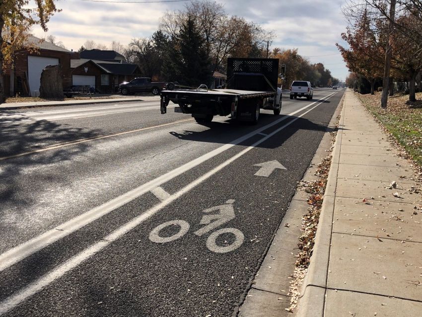
Asheville on Bikes—Merrimon Avenue Assessment                                                            February 2022

The reconfiguration of Merrimon Avenue from a four-lane street to a three-lane street with bike lanes is
supported by more than 15 years of City, MPO, and NCDOT plans and policies. It is also supported by
published design guidance and policies from the Federal Highway Administration and AASHTO.

  City of Asheville                                              NCDOT

       ✓          Complete Streets Policy (2012)                     ✓    Mission (Current)

       ✓          Comprehensive Bicycle Plan (2008)                  ✓    Complete Streets Policy (2009, 2019)

       ✓          Asheville in Motion (2016)
                                                                     ✓
                                                                          Complete Streets Planning & Design
                                                                          Guidelines (2012)
       ✓          Comprehensive Plan (2018)
                                                                     ✓    Roadway Design Manual (2021)

  French Broad River MPO                                             ✓    Context Sensitive Solutions (2003)

       ✓          Complete Streets Policy (2013)                     ✓    Vision Zero Policy (2015)

       ✓          Comprehensive Transportation Plan (2008)           ✓    WalkBikeNC Plan (2013)

       ✓          Metropolitan Transportation Plan (2020)
                                                                     ✓    Transportation-Health Policy (2012)

       ✓          Congestion Management Process (2018)
                                                                     ✓    Executive Order 246

  Federal Highway Administration                                     ✓    AECOM Traffic Study (2021)

       ✓          Safe Systems / Vision Zero
                                                                 AASHTO
       ✓          Bikeway Selection Guide
                                                                     ✓    Green Book
       ✓          Bike/Ped Design Flexibility Policy
                                                                          A Guide to Achieving Flexibility
                                                                     ✓    in Highway Design
       ✓          Road Diet Informational Guide

                                                             2
Asheville on Bikes—Merrimon Avenue Assessment                                             February 2022

                                            Key Talking Points
 Use “Road Reconfiguration” instead of “Road Diet.” This helps to better frame the purpose of the
project. Using “Road Diet” leads to a greater sense that motorists are having something taken from
    them versus having a road reconfigured to improve the operations and safety of the street.

    Highlight that the Merrimon Avenue reconfiguration is supported by more than 15 years of
transportation planning and policies, not only by the City of Asheville, but also by the French Broad
             River MPO, the MPO’s Board of elected officials, and NCDOT Division 13.

          Despite growth in areas to the north of the Merrimon Avenue Corridor—Woodfin,
               Weaverville, north Asheville—the route has experienced no increase in
                                      traffic volumes since 2000.

         There is ample support in national design guidance from the Federal Highway
   Administration and AASHTO for the reconfiguration of Merrimon Avenue, as well as within
NCDOT’s Roadway Design Manual. Speed management techniques should be applied to the design
                given it is infeasible for Merrimon to have separated bike lanes.

         There is no policy or standard dictating a level of motor vehicle traffic volumes at
  which a road reconfiguration cannot be one. Nor is there a policy or standard that dictates what
             level of motor level of service must be protected. There is only guidance,
         with FHWA noting that local agencies are free to make their own design decisions
                               based on community goals and context.

          Any road reconfiguration should come with improved traffic signal functions to
       interconnect signals, provide signal pre-emption for emergency services, time of day
 signal operations, installation of loop detection for bicyclists in the bike lanes, and “rest in walk”
 phasing for pedestrians crossing side streets. Retiming signals pre-construction should be done to
                             get motorist accustomed to the new timing.

      The City of Asheville should adopt policies to ensure that land use development along
 Merrimon Avenue results in dedication of additional right-of-way and roadway improvements to
   create: Buffered sidewalks, concrete gutter exclusive of bike lane width, bus pullouts, and
                                    consolidation of driveways.

  The City must ensure development along the corridor has site designs, densities, and uses that
 promote the multimodal vision for Merrimon so there is not future pressure to add motor vehicle
lanes. (e.g. Patton Avenue “urban village” at the old Kmart that is now going to be a typical Ingles)
                                                    3
Asheville on Bikes—Merrimon Avenue Assessment February 2022
Merrimon Avenue Context
Merrimon Avenue is a north-south arterial street that cuts through the heart
of north Asheville neighborhoods. Today, it is configured primarily as a four-
lane road with sidewalks and no bike lanes. It is a public street with the road-
way segments between the curbs managed by the North Carolina Department
of Transportation; the City of Asheville is legally required by NCDOT policy to
manage the sidewalks. Merrimon is designated as US Highway 25, which is a
relic of the function the route served prior to construction of nearby Future I-
26.
The appearance of the corridor indicates that past efforts to maximize motor
vehicle throughput have pushed the sidewalks to the minimum widths, with
no buffer from the street. Historical images from nearly 100 years ago (right)
show streetcar tracks running down Merrimon, a testament to its historic role Merrimon Avenue near Chestnut, circa 1925.
in better serving modes other than motor vehicle traffic. Source: E.M. Ball Collection, UNC Asheville
The result is a corridor that doesn’t work well for any road user, including motorists. The Federal Highway Administration high-
lights the safety issues prevalent with four-lane streets like Merrimon and supports reconfiguration to a three-lane street due to
these safety and operational factors:
• Four-lane undivided highways experience relatively high crash frequencies — especially as traffic volumes and turning move-
ments increase over time — resulting in conflicts between high-speed through traffic, left-turning vehicles and other road us-
ers. FHWA has deemed Road Diets a proven safety countermeasure and promotes them as a safety-focused design alternative
to a traditional four-lane, undivided roadway (1).
Four-lane streets that lack a center turn lane, like Merrimon Avenue, are referred to by FHWA as “de facto three-lane roadway...
where left-turning vehicles along the existing four-lane undivided roadway have resulted in the majority of the through traffic us-
ing the outside lanes.” (2)
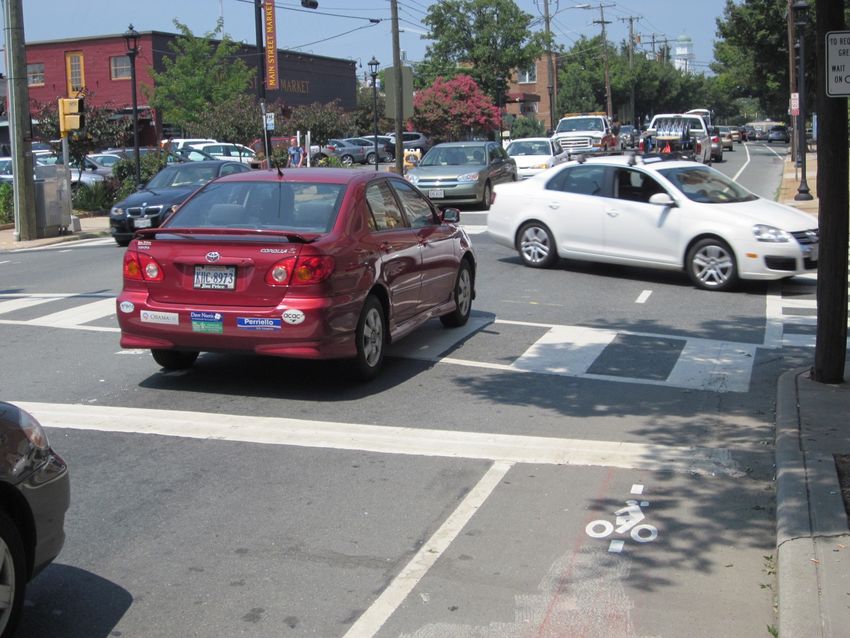
Figure 1: Proposed Roadway Reconfiguration of Merrimon Avenue
4
Asheville on Bikes—Merrimon Avenue Assessment                                                                             February 2022

By reconfiguring Merrimon Avenue to provide a two-way left turn lane, it has the potential to provide for better traffic flow and
decrease motor vehicle crashes. The added safety benefits of a roadway reconfiguration mean the fourth lane can be reallocated
to use as a lane for people who bike, which provides greater separation for pedestrians from motor vehicle traffic.

City of Asheville Supporting Actions
Complete Streets Policy. In 2012 the City of Asheville adopted its Complete Streets policy. That policy states the city “desires that
all users of our transportation system are able to travel safely and conveniently along and across all streets and roadways within
the public right-of-way in Asheville.” Further statements in the policy support the need for bicyclists of all ages and abilities to be
accommodated. It also notes that with increased congestion comes a need to provide options for people to use modes of trans-
portation other than the automobile. The policy references the City’s Comprehensive Bicycle Plan.

Comprehensive Bicycle Plan. The City’s support for bike lanes on Merrimon Avenue dates back 15 years to the start of the Com-
prehensive Bicycle Plan, which was adopted in February 2008 (4). The steering committee for the plan consisted of representa-
tives from the City, French Broad River MPO, NCDOT Division 13, and the NC Board of Transportation Bicycle Representative for
Divisions 13 and 14. This plan, which was funded and endorsed by NCDOT, states this:

•    “The primary goal of this Plan is to provide transportation alternatives and to enhance quality of life by creating continuous
     linear bicycle connections, providing bicycle facilities for the full range of users, and increasing safety and mobility of bicyclists
     in Asheville.” (page 4)

The proposed reconfiguration of Merrimon Avenue supports this vision. The Plan designates Merrimon Avenue for a “lane diet”
for much of its length. This stemmed from online input from 800 survey respondents where Merrimon was highlighted as a route
in need of improvements for people who bike. In that plan, a lane diet was noted as a restriping of roadways to narrow motor
vehicle travel lanes in order to add bike lanes. Merrimon is noted in the plan as being in most need of a climbing lane for bicyclists
in uphill stretches and posed as having some type of shared lane applications elsewhere.

Asheville in Motion. Adopted in 2016 and developed with participation from NCDOT Division 13, the Asheville in Motion (AIM)
plan sought to integrate the City’s past transportation efforts into a single document. Merrimon is designated to have bike lanes
as part of the city’s proposed system of secondary bicycle routes. It is also shown to be a corridor for premium bus services. These
designations indicate the City views Merrimon as a street that serves transportation functions beyond motor vehicle speed and
volume, as its City Connector designation suggests. This supports reconfiguring it to serve other modes more safely and conven-
iently than it does in its current configuration. (5)

Figure 2: Merrimon Avenue identified as City Connector in Asheville in Motion Plan.

                                                                     5
Asheville on Bikes—Merrimon Avenue Assessment                                                                        February 2022

Comprehensive Plan. The City’s Comprehensive Plan (6) echoes the goals and objectives of the Asheville in Motion Plan, with nota-
ble sections on increasing access to safe bicycling and making streets walkable. Its vision states:
• Transportation and Accessibility: Whether you drive a car, take the bus, ride a bike or walk, getting around Asheville is easy.
     Public transportation is widespread, frequent, and reliable. Sidewalks, greenways, and bike facilities get us where we want to
     go safely and keep us active and healthy. It is easy to live in Asheville without a car and still enjoy economic, academic, and
     social success. (page 59)

Page 151 of the Themes document notes: “Where feasible, the preferred method is to provide buffered bike lanes or, bike facilities
physically separated from vehicular traffic...Identify and pursue major corridor-level retrofits and upgrades for bicycle infrastruc-
ture and connectivity.”

FBRMPO Supporting Actions
The French Broad River MPO is the federally-designated transportation planning organization for the Asheville region. Much like
the City’s planning efforts, FBRMPO’s plans also provide ample support for the roadway reconfiguration of Merrimon.

Complete Streets Policy. Adopted in February 2013, the MPO’s policy states, “FBRMPO will seek incorporation of the Complete
Streets concept and policy into the development of all transportation infrastructure within the region at all phases of their develop-
ment, including planning, scoping, design approvals, implementation, and performance monitoring.” It also states the MPO pur-
pose with regard to the City’s plans and NCDOT’s Complete Streets policy:
• “To act in concurrence with North Carolina Department of Transportation Complete Streets Policy and any locally-adopted
    Complete Streets policies and transit, bicycle and pedestrian plans.” (7)

Comprehensive Transportation Plan. The 2008 CTP set forth many of the current efforts for the FBRMPO with its designation of
Merrimon Avenue as “Needs Improvement” from a bicycling perspective (page 55; Figure 3). The plan notes Merrimon Avenue as a
lower priority when it comes to motorist-based highway investments (page 87; 2-3), denoting it may need spot intersection im-
provements such as turn lanes. (8)

Metropolitan Transportation Plan 2045. The MTP includes a Horizon Year 2040 project that specifically denotes application of a
road reconfiguration on Merrimon Avenue, with an estimated cost of $10.89 million (page 89). This is consistent with the goals of
the MTP, including the first goal listed in the MTP to “Improve Multimodal Transportation” through improving “bicycle and pedes-
trian safety,” increasing “utilization of other modes,” and improving “multimodal network connectivity.” The second goal is to
Figure 3: FBRMPO Comprehensive Transportation Plan Bicycle Map

                                                                  6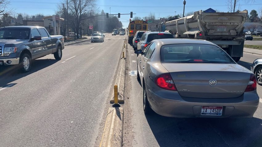
Asheville on Bikes—Merrimon Avenue Assessment                                                                      February 2022

“improve safety.” (page 20). Specifically, the FBRMPO MTP outlines objectives that support the Merrimon Avenue reconfiguration:
        • Increase the miles of bicycle infrastructure to make bicycling a safer, more attractive way of making trips.
        • Increase the number of trips made by transit, biking, and walking.
        • Improve first/last mile connections for transit users.
        • Improve connectivity of pedestrian and bicycle infrastructure. (9)

Congestion Management Process. The Vision for this 2018 plan states, “The FBRMPO will promote a safe and efficient transporta-
tion system that increases transportation options and enhances the environment and livability of the region through a well-
integrated roadway, transit, rail, pedestrian, and bicycle network.” It also states the MPO desires to “Improve multi-modal and non
-motorized transportation options” and “Improve safety on surface streets and highways.”

That bicycle network element is supported for Merrimon Avenue, as shown in Figure 4. It denotes Merrimon should have improved
bicycle and pedestrian infrastructure and crossings, and should have a relaxed Level of Service consideration in order to achieve
this. The CMP mirrors the CTP with Merrimon, showing spot operational improvements (e.g. turn lanes) for vehicle traffic. (11)

NCDOT Supporting Actions
As noted above, NCDOT Division 13 staff and its then-NCDOT Board of Transportation Bicycle Committee representative for Divi-
sion 13 and 14, participated in the process to designate Merrimon for a road reconfiguration project in the City’s Comprehensive
Bicycle Plan. That plan was reviewed and formally endorsed by NCDOT’s Division of Bicycle and Pedestrian Transportation. NCDOT
has also been involved on the other supporting actions and plans from the City and FBRMPO. The Merrimon Avenue reconfigura-
tion is fully supported by both these past actions and the following policies and plans endorsed by NCDOT.

Mission. NCDOT’s mission is: Connecting people, products and places safely and efficiently with customer focus, accountability and
environmental sensitivity to enhance the economy and vitality of North Carolina.” With a focus on people instead of automobiles,
Figure 4: FBRMPO Congestion Management Process Corridor Profile for Merrimon Avenue

                                                                 7
Asheville on Bikes—Merrimon Avenue Assessment                                                                           February 2022

as well as understanding people who bike need to get places safely and efficiently, the Merrimon project fits within its mission.

Context Sensitive Solutions. In the early 2000s, NCDOT embarked on what became a predecessor to current Complete Streets and
Vision Zero/Safe Systems strategies. The effort known as Context Sensitive Solutions (CSS) or Context Sensitive Design. The purpose
of NCDOT’s Context Sensitive Solutions (CSS) Goals and Working Guidelines stated it was to:
• “Provide a framework to implement the Context Sensitive Solutions training with the ultimate goal of an infrastructure that
     provides safe and effective transportation while preserving and enhancing where possible the natural and human environ-
     ment.” (12, page 1)

Further, it supports the process used to reach the recommendation for a Merrimon reconfiguration, most notably the stated values
of the City of Asheville and FBRMPO:
• “NCDOT employees will be the focal point for the human environment needs as we provide transportation infrastructure to
     our customers. We will solicit input from all stakeholders in every way needed to ensure all relevant needs are addressed and
     answers are provided to the suggestions and questions. Seeking first to understand the values and interests of the communi-
     ties and genuinely evaluating the input prior to pre-judging their responses.” (12, page 1-2)

Finally, NCDOT notes in its CSS Goals and Working Guidelines that the agency would (emphasis added): “Understand how to use
the AASHTO Design Guide and its fullest range of options to achieve maximum flexibility in design.” This concept of flexibility is
noted in the section on FHWA support.

Complete Streets. Originally adopted in 2009 and updated in 2019, NCDOT’s Complete Streets policy aspires to create conditions
where the agency provides facilities for all users of all ages and abilities on the state’s routes. The primary language from that poli-
cy is shown below in Figure 5. (13)

The accompanying Complete Streets Planning and Design Guidelines (14) from 2012 supports road reconfigurations through:

Figure 5: NCDOT’s Complete Streets Policy

                                                                   8
Asheville on Bikes—Merrimon Avenue Assessment                                                                       February 2022

•   Street conversions or road diets by restriping     Figure 5: Road Diets Profiled for NCDOT’s Complete Streets Effort
    and reassigning lanes (page 142)
•   Pavement restriping (similar to maintenance
    projects): Convert streets or use road diets to
    provide a full bike lane; Reduce lane widths to
    provide a full bike lane. (page 144)

On its Complete Streets website, NCDOT showcases
other road reconfiguration projects implemented in
North Carolina (Figure 5). This includes the East
Boulevard Road Diet in Charlotte, which has similar
characteristics to what is proposed on Merrimon (see
page 30).

The illustrative street cross sections in the NCDOT
Complete Streets Planning and Design Guidelines         https://www.completestreetsnc.org/project-examples/
bolster support of what is proposed for specific design elements on Merrimon Avenue. The overall guide includes several design
treatments, including bike lanes and 10-ft wide motor vehicle lanes as suitable design options for avenues (Figure 6 below; page
75).

Roadway Design Manual. NCDOT updated its roadway design manual in 2021. Chapter 4 of that manual addresses Cross Section
Elements and provides design support for both what is proposed by the City and NCDOT on Merrimon, as well as support for con-
sideration of the additional cross section features recommended in this assessment for AOB. Specifically:

•   4.3 Lane Widths (page 4-1): Lane widths for arterials range from 10 to 12 feet. On high speed, free flowing urban arterials, 12-
    foot lanes are preferred. When truck and bus traffic is low and speed is less than 35 mph, 10-foot lane widths may be used.

•   4.15.3 Bicycle Lanes (page 4-33): Desirable width – 6 to 7 feet, especially adjacent to on-street parking; Minimum width – 5
    feet, not inclusive of gutter pan.

Figure 6: NCDOT Complete Streets Planning and Design Guidelines, Urban/Suburban Avenue

                                                                 9
Asheville on Bikes—Merrimon Avenue Assessment February 2022
• 4.15.4 Buffered Bicycle Lanes (page 4-33): A buffered bicycle lane is a Figure 7: Section from WalkBikeNC Design Guidance
bicycle lane separated from the adjacent traffic lane and parking by
longitudinal pavement markings. The buffer area might include chev-
ron or diagonal markings, typically at least 2 feet wide. Use this type
of facility when a separated bicycle lane is desired but not feasible.
(15)
Vision Zero. The 2019 Complete Streets Policy update includes a refer-
ence to Vision Zero, which is a policy NCDOT adopted in 2015. It states,
“The Vision Zero strategy establishes a long-term vision of zero fatalities
on North Carolina roadways through sustained efforts in engineering,
enforcement, education, emergency response, and public policy.” (16)
In 2020, nearly 17% of traffic deaths in North Carolina were someone
who was walking or bicycling (17). Strategies like those proposed for
Merrimon would address some of the key causes of these deaths, which
are shown in nationwide research to be: The speed of a motorist, lack of
dedicated facilities, lack of protected facilities, and lack of safe crossings.
FHWA has pivoted from using the term Vision Zero and now uses Safe
Systems (see page 11) to showcase these needed safety interventions set
forth in NCDOT’s Vision Zero policy.
Walk Bike NC. The statewide bicycle and pedestrian plan was adopted by
the NCDOT Board of Transportation in December 2013. Called WalkBikeNC,
the plan “lays out a framework for improving bicycle and pedestrian trans-
portation as a means to enhance mobility, safety, personal health, the
economy, and the environment.” The plan includes sections on these vari-
ous topics and references prevailing federal pedestrian and bicyclist design
guidance in place at the time of adoption. The plan include a design toolbox
with road reconfigurations mentioned as a way to decrease crossing dis-
tances on roadways for pedestrians. This is most notable in terms of access-
ing transit and being able to more safely cross a street.
The environment chapter of WalkBikeNC acknowledges the benefits of in-
creased walking and bicycling in terms of reducing greenhouse gas emis-
sions. (18)
Transportation-Health Policy. In 2012, the NCDOT Board adopted a Transportation-Public Health Policy (19), which is referenced in
the WalkBikeNC plan. This policy acknowledges “Inactivity among North Carolinians has contributed to higher rates of chronic dis-
eases, lower levels of overall health and well-being, and therefore higher health care costs. It then states:
• The North Carolina Department of Transportation may have opportunities to support positive health outcomes by considering
public health implications in our decision-making across all transportation modes, programs, policies, projects, and services,
and through all stages of the life of a transportation project from planning to project development, construction, operations,
and maintenance. Specifically, we can consider:
A multi-modal transportation system to provide access to and options for customers of all abilities and capabilities;
The safety for all users and all modes of transportation; and
The potential for the transportation system to support human health.
Executive Order 246, Greenhouse Gases, & Climate Science Report. On January 7, 2022, NC Governor Roy Cooper signed this ex-
ecutive order stating the 2020 North Carolina Climate Science Report “found that adverse impacts of climate change in North Caro-
lina threaten human health, the State’s economy, and our quality of life.” That Executive Order also states, “, all North Carolinians,
10Asheville on Bikes—Merrimon Avenue Assessment February 2022
irrespective of economic status, cultural heritage, race, religion, or zip code, have the right to enjoy a sustainable environment with
clean air, clean water, and clean soil and that is free from environmental injustice.” This aligns with the environmental themes
adopted within WalkBikeNC.
The Merrimon reconfiguration supports these statements, as well as the order for NCDOT to develop a Clean Transportation Plan
that shall address (emphasis added):
• Increased availability, sales, and usage of ZEVs to levels beyond current market projections; reductions in vehicle miles trav-
eled; investment in clean transportation infrastructure; equitable access to clean mobility options; increased availability of
non-vehicle transportation modes; a transition to zero- and low-emission fuels; and other relevant topics. (20)
Federal Highway Administration Supporting Actions
FHWA provides substantial guidance and support for roadway reconfigurations like the one proposed for Merrimon Avenue. FHWA
does this through endorsement of various design guides and policies that collectively support efforts such as Vision Zero (Safe Sys-
tems), NCDOT’s Context Sensitive Solutions, Complete Streets, and other published policies. This section provides a summary of
those policies and design guides.
Vision Zero/Safe Systems. The United States leads the world’s wealthy nations in traffic deaths. The emerging science is showing
that these are the results of a lack of system-level efforts to reduce deaths. For roadway design, it means understanding that hu-
mans make mistakes when driving, walking, or bicycling. Too many of today’s streets, Merrimon included, are engineered so that
the slightest mistake can result in a road user’s death. The Yvonne Coleman death while walking across Merrimon showcases this.
Regardless of the type of mistake made by the victim or the driver, FHWA’s Zero Deaths and Safe System approach is founded:
• “The principles that humans make mistakes and that human bodies have limited ability to tolerate crash impacts. In a Safe Sys-
tem, those mistakes should never lead to death. Applying the Safe System approach involves anticipating human mistakes by
designing and managing road infrastructure to keep the risk of a mistake low; and when a mistake leads to a crash, the impact
on the human body doesn’t result in a fatality or serious injury. Road design and management should encourage safe speeds
and manipulate appropriate crash angles to reduce injury severity.” (21)
Merrimon’s current design means that the mistakes that people make when using it have a higher likelihood of resulting in a death
or disabling injury. A bicyclist attempting to use the route may be sharing a lane with a much faster and larger motor vehicle. A
slight move or fall by the bicyclist or a veering out of the adjacent lane by a motorist could result in death. Ms. Coleman’s death
could have been mitigated with more frequent and safer crossings, as well as safer speeds along Merrimon.
Bicycle and Pedestrian Facility Design Flexibility. The approved set of guides adopted by FHWA support the Safe System approach,
including several national design guides for bicyclist and pedestrian facility design. On August 20, 2013, FHWA issued a memoran-
dum titled “Bicycle and Pedestrian Facility Design Flexibility.” In it, they endorse several publications from AASHTO, NACTO, and
ITE, stating “FHWA supports the use of these resources to further develop nonmotorized transportation networks, particularly in
urban areas.” It cites a 2010 USDOT policy statement that aligns with many of the same themes highlighted in NCDOT’s adopted
policies and guides:
• “DOT encourages transportation agencies to go beyond the minimum requirements, and proactively provide convenient, safe,
and context-sensitive facilities that foster increased use by bicyclists and pedestrians of all ages and abilities, and utilize univer-
sal design characteristics when appropriate." (22)
Road Diet Informational Guide. Contrary to popular belief, there is no FHWA policy or standard by which a road reconfiguration
should be considered or determined infeasible. Oftentimes, opponents of road diet/road reconfigurations cites motor vehicle
traffic thresholds to make a case against reconfiguring 4 lanes to become 3 lanes.
FHWA Road Diet Information Guide, Section 3.3.5—Average Daily Traffic, states:
• “The ADT provides a good first approximation on whether or not to consider a Road Diet conversion. If the ADT is near the up-
per limits of the study volumes, practitioners should conduct further analysis to determine its operational feasibility. This
would include looking at peak hour volumes by direction and considering other factors such as signal spacing, turning volumes
at intersections, and other access points. Each practitioner should use engineering judgment to decide how much analysis is
11Asheville on Bikes—Merrimon Avenue Assessment February 2022
necessary and take examples from this report as a guide. A 2011 Kentucky study showed Road Diets could work up to an
ADT of 23,000 vehicles per day (vpd). In 2006, Gates, et al. suggested a maximum ADT of between 15,000 and 17,500 vpd.
Knapp, Giese, and Lee have documented Road Diets with ADTs ranging from 8,500 to 24,000 vpd. The FHWA advises that
roadways with ADT of 20,000 vpd or less may be good candidates for a Road Diet and should be evaluated for feasibil-
ity...Road Diet projects have been completed on roadways with relatively high traffic volumes in urban areas or near larger
cities with satisfactory results.”
Further, FHWA’s guide dispels another myth that preserving some level of motorist level of service is a safety measures, which it is
not. Section 3.3.3 on Level of Service (LOS) states: “Level of Service (LOS) is a qualitative measure of traffic conditions using a quan-
titative stratification of a performance measure or measures.”
FHWA includes a section in this guide on Quality of Service factors when evaluating pedestrian and bicyclist experience on a route
that is reconfigured.
• Pedestrian LOS scores are likely to improve due to the lane reduction, speed reduction, and the reallocation of traveled way
width to bicycle lanes and on-street parking.
• Bicycle LOS scores will improve as a result of some of the same factors, as well as the addition of a bicycle lane.
• Applying a Road Diet configuration on a corridor with frequent signalized intersections will have a larger impact on auto-
mobile operations than it would on a corridor with more infrequent signal spacing. Frequently spaced signals are more likely
to have queued traffic back up into adjacent signals' effective areas, causing congestion issues at multiple intersections. In
some cases this impact can be mitigated by optimizing the signal timing and coordinating between signals. The arterial auto-
mobile LOS will provide a more accurate view of conditions when there are longer distances between signalized intersections
or only unsignalized intersections in the corridor.
Section 3.4.1 addresses Bicycle Considerations, most notably:
• “Whether or not there is existing activity, demand for a bicycle facility should be estimated. In cases where there are already
bicycle facilities, a Road Diet may be an opportunity to further enhance the comfort of bicyclists by adding buffer space or
converting a standard bicycle lane to a protected bicycle lane. Adding buffers may have additional benefits to other users as
well. For instance, where the goal is to lower speeds, adding buffers to narrow travel lanes may accomplish that, which
would be a benefit to pedestrians as well as bicyclists.” (23)
AASHTO’s A Guide for Achieving Flexibility in Highway Design. These statements from FHWA’s Road Diet Information Guide are
consistent with another federally-endorsed design guide, AASHTO’s Achieving Flexibility in Highway Design. It was developed in
the early 2000s as agencies like NCDOT were pursuing their Context-Sensitive Solutions efforts. (24)
Regarding concern over modeled level of service in 2045 on the Merrimon Avenue AECOM study, the flexibility guide states in Sec-
tion 1.4.5 on Level of Service:
• “The AASHTO Green Book and many agencies provide general guidelines on design level of service for different condi-
tions...Failure to achieve a level of service indicated in [the Green Book LOS table] does not constitute a non-standard de-
sign decision. Indeed, it is common practice in major metropolitan areas to routinely design for a certain levels of congestion
(level of service D or E)...The Green Book includes discussion of the implications of and recommendations for designing for
congestion, thus implying recognition of the practical problems associated with always providing a certain minimum level of
service.”
Regarding the 10-ft wide travel lanes proposed on Merrimon, AASHTO supports this in its flexibility guide, specifically in Section
3.6.1 on Lane Widths:
• “In urban areas...narrower lane widths may be appropriate. For such locations, space is limited and lower speeds may be
desired. Narrower lane widths for urban streets lessen pedestrian crossing distances...and enable the development of left-
turn lanes for safety. Lesser widths also encourage lower speeds...In considering the use of narrower lanes, however, de-
signers should recognize that narrow travel lanes reduce vehicle separation from other vehicles and bicyclists.” (page 64)
12Asheville on Bikes—Merrimon Avenue Assessment February 2022
• “There is less direct evidence of a safety benefit associated with incrementally wider lanes in urban areas.” (page 64)
Section 3.6.1.2 highlights the flexibility in the AASHTO Green Book, which is used extensively by agencies like NCDOT to develop
their own design manuals. It states:
• “The AASHTO Green Book recognizes the need for flexibility and provides that flexibility, citing how lane widths can be tai-
lored, to a degree, to fit the particular environment in which the roadway functions...The discussion of lane width in the
AASHTO Green Book for urban areas also reflects a high degree of flexibility. It is noted that lane widths ‘may vary from 10
to 12 ft for arterials.” (page 65)
Finally, in terms of design speed for a future Merrimon reconfiguration, the AASHTO Flexibility Guide states: “Given the historic
equating of design speed with design quality, the notion of designing a high quality, low speed road is counter-intuitive to some
highway engineers. Yet it is in many cases the appropriate solution to a sensitive neighborhood or other street design problem.
Context-sensitive solutions for the urban environment often Figure 8: AASHTO Green Book Section on Target Speed
involved creating a safe roadway environment in which the
drives is encouraged by the roadway’s features and the sur-
rounding area to operate at low speeds.” (page 19)
AASHTO Green Book. The concept of designing for a low speed
environment is bolstered in the latest edition of the AASHTO
Green Book, published in 2018. Section 2.3.6.3 on Design
Speed includes the statement in Figure 8 on Target Speed. That
is what is attempting to be achieved with the Merrimon reconfiguration. (25)
FHWA Bikeway Selection Guide. FHWA published this guide in 2019 to “help transportation practitioners consider and make in-
formed trade-off decisions relating to the selection of bikeway types.” It applies Safe System concepts pertaining to helping guard
against fatal consequences of human error and contains guidance on the traffic conditions that should guide designers in deter-
mining the most appropriate type of bikeway on a particular street. Figure 9 shows the differences between a shared lane like
Merrimon has today versus the proposed bike lanes that would come with a reconfiguration. It supports design treatments that
Figure 9: FHWA Bikeway Selection Guide
https://safety.fhwa.dot.gov/ped_bike/tools_solve/docs/fhwasa18077.pdf
13Asheville on Bikes—Merrimon Avenue Assessment February 2022
make the target speed of Merrimon one that is low to increase comfort. Unprotected bike lanes have a moderate effect on safety
since an error by a motorist means they can easily encroach upon the bike lanes. (26)
Figure 10 is a key element of that Bikeway Selection Guide. The matrix represents the preferred bikeway type for urban, urban
core, suburban, and rural town contexts. The X-axis is where vehicle speeds are plotted against daily traffic volumes on the Y-axis.
Merrimon Avenue is literally “off the charts” when it comes to where it would plot on this map. Traffic volumes are in excess of
18,500 all along the route, which places the recommended bicycle facility in the category of a separated bike lane. The posted
speed limit along Merrimon is 35 mph from I-240 to the north project limits, which also places it squarely in the category for war-
ranting a separated bike lane.
These results showcase the justification for these key findings for the City and NCDOT to consider:
• Shared Lanes (current): Merrimon’s current status clearly justifies some type of dedicated bike lane. Shared lanes are not
sufficient from either a volume or a speed perspective.
• Standard Bike Lanes (proposed), like shown in the City and NCDOT proposed design, are not sufficient from a volume and
speed perspective. Designing for a target speed of 30 mph would allow the standard bike lanes to be considered borderline if
volumes were not a factor.
• Buffered and Protected Bike Lane (preferred): The cross sections proposed on pages 23-24 show how to accommodate a buff-
ered and (somewhat) protected bike lane in 40-ft, 44-ft, and 48-ft curb-to-curb cross sections along Merrimon. These should
Figure 10: FHWA Bicycle Facility Selection Matrix with Merrimon Posted Speed & Volume
2020 counts: 18,500 north of W.T. Weaver; 2018 counts: 24,000 north
of I-240, 21,500 north of Chestnut, 22,500 north of Edgewood
Source: Federal Highway Administration Bikeway Selection Guide
14Asheville on Bikes—Merrimon Avenue Assessment February 2022
be considered in the design along with a target speed of 30 mph or less. This will help maximize usability of the corridor and
maximize safety given the route’s current constraints. (26)
Function & Safety
This section includes an evaluation of the Merrimon Avenue Road Diet Traffic Capacity Analysis conducted by NCDOT in 2021, as
well as other background data and factors to consider. The NCDOT traffic capacity analysis for
Merrimon Avenue evaluates conditions for motorists with no analysis of conditions for other
users of the corridor.
Due to this omission of non-motorized analysis, this section also includes use of a Level of
Traffic Stress tool that is recommended in the ITE Trip Generation Manual as being a more
applicable method than bicyclist and pedestrian level of service methods contained in the
Highway Capacity Manual methods and software utilized by NCDOT on the traffic capacity
analysis.
NCDOT/AECOM Traffic Study. The northbound and southbound level of service results of the
study were the focus of this assessment since they represent the conditions for motorists
using Merrimon. East-west movements calculated in this study are for the side streets that
intersect Merrimon and provide relatively minor function in the overall system (with the ex-
ception of W.T. Weaver Blvd). A level of service on these intersecting streets is likely more
related to traffic signal timing preferences to prioritize movement on Merrimon. (27)
An indicator of this can be traced through the different alternatives for the Merrimon at Shopping Center Dwy/Ottari Road inter-
section. Westbound Left/Through/Right is modeled to be LOS E in 2019 and in every 2045 scenario evaluated (e.g. that congestion
is not related to any road reconfiguration option).
If there is an interest to mitigate modeled congestion on these east-west legs, additional lanes may be added to them to allow for
right or left turns. This may occur through requirements placed on redevelopment of the properties. However, such a requirement
was not placed upon the Harris Teeter and Trader Joe’s developments at Chestnut, which suggests neither NCDOT nor the City of
Asheville were concerned with level of service on these east-west routes. Therefore, it is not a reason to suggest today that a road
reconfiguration not be considered due to those same concerns.
Some notable elements of Merrimon’s southbound and northbound trips are contained below where they are modeled to be at
LOS E or F under any modeled scenario.
• 2019—Merrimon, southbound and northbound trips
Level of Service E or F: Northbound and Southbound at I-240 ramps (PM peak only); Southbound left turns at Coloni-
al/Gracelyn.
• 2045—Merrimon, No Build, southbound and northbound trips
Level of Service E or F: Northbound and Southbound at I-240 ramps.
• 2045—Merrimon, Build Alternative 1 (Road Diet), southbound and northbound trips
Level of Service E or F: Northbound and Southbound at I-240 ramps; Southbound left at Colonial/Gracelyn; South-
bound left at Osborne/Beaverdam;
• 2045—Merrimon, Build Alternative 2 (Broadway connector; No Road Diet), southbound and northbound trips
Level of Service E or F: Northbound left at Shopping Center Driveway (Harris Teeter); Southbound left at Colonial/
Gracelyn.
• 2045—Merrimon, Build Alternative 3 (Broadway connector; With Road Diet), southbound and northbound trips
Level of Service E or F: Southbound left at Chestnut; Southbound left at Hillside (AM peak only); Northbound left and
Southbound through/right at Weaver; Southbound left at Colonia/Gracelyn; Southbound left at Osborne/Beaverdam
(PM peak)
15Asheville on Bikes—Merrimon Avenue Assessment February 2022
Figure 10: FHWA Bicycle Facility Selection Matrix with Merrimon Posted Speed & Volume
Therefore, this assessment’s findings are consistent with the City and NCDOT recommendations:
• The proposed road reconfiguration is not a major influence on motorized traffic level of service under either scenario.
• Additionally, any modeled changes to traffic on Charlotte Street due to people choosing it over Merrimon is negligible (see
Figure 10, next page).
Traffic Counts—Historic vs. Projected. There is even greater cause for optimism for those concerned with traffic forecasts and
projected delays along Merrimon in the future—with or without a road reconfiguration. Figure 11 plots NCDOT traffic counts and
the AECOM traffic study for Merrimon at a location just north of W.T. Weaver Boulevard. Despite traffic counts that show volumes
are steady or declining on Merrimon, the traffic forecast to 2045 still shows growth if Merrimon remains in its current configura-
tion. It is not explained in the traffic study how 20 years worth of data showing a downward trend line in traffic could result in a 20
Figure 11: Merrimon Traffic Volumes: 2000-2020 Actual vs. 2020-2045 Forecast
16Asheville on Bikes—Merrimon Avenue Assessment February 2022
-year growth forecast showing a 28.5% increase in traffic over a trend that shows volumes around 21,000 and maintaining. The
modeled volumes in the AECOM study show 2045 volumes of close to 24,500.
This is likely the result of simply plugging in FBRMPO growth assumptions without verification of that growth or if it can even occur.
The likely reason for Merrimon maintaining traffic volumes around 21,000 for the last 20 years is that the corridor has reached a
functional capacity, which reflects reality more than a modeled demand represented in the AECOM study.
Weaverville/Woodfin Growth. The traffic volumes remaining relatively constant along Merrimon have occurred while there has
been notable growth in Woodfin and Weaverville. From 2000 through 2020, the combined populations of Woodfin and Weaver-
ville grew by 28%, or nearly 2,400 people to 10,900. Despite that growth, as well as growth in other Census tracts in unincorpo-
rated Buncombe County north of Asheville, the traffic volumes on Merrimon have remained close to 21,000. (Figure 12)
This supports the theory that Merrimon has reached a functional capacity and that people are either finding other routes to get to
Asheville or bypassing the City altogether for jobs and shopping elsewhere along the I-26 corridor.
Either way, claims that Merrimon must remain in its current status or be widened to accommodate more traffic based on projected
growth in Woodfin and Weaverville is not supported by history.
National Highway System Designation & NCDOT Priorities. Figure 13 on the following page shows the area of north Asheville from
NCDOT’s online map of National Highway System (NHS) routes. Despite being designated as US Highway 25, Merrimon is not part
of the NHS. Interstates 26, 240 and 40 are part of the NHS as are Patton Avenue. Instead of Merrimon, Broadway is instead desig-
nated as the route from Future I-26 to I-240, where it then transitions to US 25 south of I-240 and continues through downtown to
McDowell Street and to the south. NHS routes are typically subject to greater scrutiny by Federal Highway Administration when it
comes to things like vehicle throughput and level of service due to their role in the greater transportation system for the country.
Since Merrimon is no longer part of the NHS, there is little justification to preserve it for current or future vehicle throughput, al-
Figure 12: Growth & Traffic—Woodfind & Weaverville Population vs. Merrimon Traffic Counts
17Asheville on Bikes—Merrimon Avenue Assessment February 2022
lowing the City of Asheville to realize its vision for Merrimon. Figure 13: NCDOT National Highway System Map of Asheville Area
Adding to this lessened importance is NCDOT’s offering to the
City of Asheville to have the City assume responsibilities for all
facets of Merrimon, not just its sidewalks. If Merrimon were a
corridor of strategic statewide significance, then it stands to
reason that NCDOT would not have been so willing to give the
corridor to the City of Asheville. Unfortunately, the state of
North Carolina does not provides cities with ample tools and
funding opportunities to take routes that are burdensome to
NCDOT and transition them to local control. The NHS status of
Merrimon should be confirmed through the City, NCDOT, and
FBRMPO.
Multimodal LOS Analysis. Neither pedestrian nor bicyclist level
of service analysis was performed as part of NCDOT’s traffic
capacity analysis. The Highway Capacity Manual software used
by firms like AECOM often include modules that use the same
motorize traffic inputs, combined with observable in-the-field
features or proposed designs, to help generate a level of service
score for pedestrians, bicyclists, and transit riders.
It is unclear why NCDOT chose to not conduct this multimodal
LOS analysis alongside its motorized traffic analysis.
The City of Asheville did perform a bicyclist level of service anal- Also: https://www.fhwa.dot.gov/planning/national_highway_system/nhs_maps/
ysis, which is shown in Figure 14. It shows that the existing con- north_carolina/index.cfm
Figure 14: City of Asheville Bicycle LOS for Merrimon
18Asheville on Bikes—Merrimon Avenue Assessment February 2022
ditions along Merrimon are at a LOS D for people who bike, which aligns with a low compatibility score for people wishing to go by
bike. The proposal to add unbuffered, unprotected bike lanes improves that compatibility to LOS C.
There are limitations to the existing LOS methods for bicyclists and critics will cite that it is developed around a single type of bicy-
clist and does not account for people who may be less confident bicyclists.
Level of Traffic Stress. Due to the limitations of level of service methods for pedestrians and
bicyclists, the ITE Multimodal Transportation Impact Analysis for Site Development (MTIA)
publication recommends Level of Traffic Stress (LTS) as a better measure. The outcomes of a
LTS analysis are more easily interpreted by the public and relatable to bicyclists.
Figure 15 illustrates the concept of LTS as it relates to on-street facilities. A rating of LTS 4
(highest stress) means a route lacks bicycle lanes on a busy street, like with Merrimon. It is
shown to be uncomfortable for most riders. A route with LTS 3 is similar to what is proposed
on Merrimon with paint-only bike lanes and is shown to be comfortable for confident bicy-
clists with increasing stress for most.
A route with LTS 2, like could occur on Merrimon with buffered bike lanes, some type of ver-
tical protection, and designing it for a target speed of 25 mph to 30 mph, would mean it is
comfortable for most adults. A completely separated facility is LTS 1 (lowest stress) and is
comfortable for all riders. LTS 1 is not likely attainable on Merrimon under any scenario.
Like with the bicycle LOS performed by the City that shows a change of one grade from LOS
D to LOS C with the paint-only bike lanes, the LTS improvement is one grade from LTS 4 to
LTS 3.
Figure 16 on the following page is a series of LTS measures generated by Alta Planning + De-
sign for the Ada County Highway District in Boise, Idaho. It shows the deeper relationships between how to measure LTS as it re-
Figure 15: Level of Traffic Stress (LTS)
Source: Alta Planning + Design
19Asheville on Bikes—Merrimon Avenue Assessment February 2022
Figure 16: Level of Traffic Stress (LTS), Adapted by Alta Planning + Design for Ada County Highway District
20Asheville on Bikes—Merrimon Avenue Assessment February 2022
lates to number of lanes and speed. Another LTS measure for bicyclists is having to cross routes like Merrimon to reach their desti-
nations. This LTS measure should be incorporated into the design to determine the best crossing treatments.
Additionally, the tables at the bottom of Figure 16 are LTS for pedestrians. The current sidewalks along Merrimon would place it in
a range of LTS 4 under current conditions with the road reconfiguration moving it to LTS 3 due to a reduction in vehicle lanes. Pro-
ject design should target LTS 2 or better, recognizing some improvements may have to occur through future redevelopment.
Cross Section Options for Merrimon
The FHWA Bikeway Selection Guide, referenced earlier, provides some diagrams on what types of facilities bicyclists will use and it
indicates that paint-only bike lanes are desirable to a relatively small percentage of riders. Figure 17 shows that bike lanes or buff-
ered bike lanes without protection will likely appeal to less than 10% of bicyclists. Creating a separated or protected bike lane has
the most opportunity to see widespread change. NCDOT cites this guide for use as part of its Roadway Design Manual (15).
Given that, the realities of Merrimon Avenue are the corridor is largely built out from a land use perspective and any changes in the
existing cross section, in terms of curb to curb space, would need to occur as properties redevelop. Moving curbing can be expen-
sive due to impacts to stormwater conveyance. The cross sections on the following pages reflect the possibilities to deviate from
Figure 17: Which Facilities Will Make Riders Feel Safer
21Asheville on Bikes—Merrimon Avenue Assessment February 2022
the proposed cross section (see Figure 1 on page 4) to help improve LTS
and take advantage of locations where the curb to curb section is great-
er than 40 feet in width.
Curb and Gutter. First, a concrete gutter pan must never be counted as
bike lane width. The seam between asphalt and concrete at these loca-
tions creates unsafe conditions for bicyclists to navigate. The AASHTO
Green Book notes that “a gutter of contrasting color or texture (black
asphalt vs gray concrete) should not be considered part of the traveled
way.” NCDOT’s Complete Streets Planning and Design Guidelines in-
clude footnotes in the cross sections that state:
• “The gutter pan is not considered part of the lane width or the No gutter and street is almost level with the sidewalk.
bicycle lane width.” (14)
The application of concrete gutters along Merrimon is inconsistent due
to the piecemeal development that has occurred over several decades.
The southern portions of the corridor under assessment have asphalt
paved to the edge of the curb with no concrete gutter.
The images at right show the varying types of curbing present, even in
short segments along Merrimon. Over time, repaving of Merrimon has
also caused the roadway surface to be almost flush with the sidewalk in
some areas, with little recognizable curbing. Given the scope of the Mer-
rimon reconfiguration, the corridor is not likely to see a broad rebuild of
the curbside environment to add continuous gutters. Gutter starts and stops within the same block.
In theory, even when there is no gutter pan, with asphalt placed right
up to the curb, the outside foot or so tends to act as a gutter pan for
stormwater flows during rain events. Given Asheville’s frequent rain fall,
it would be advised that Asheville on Bikes to go out during rain events
to take images and videos of how water flows adjacent to the curb
when there is no gutter pan. The flow of water adjacent to the curb
must be considered if the bike lane is to be usable in year-round condi-
tions. Leaving only 4 feet of width in the bike lane immediately adjacent
to 10 ft wide travel lanes can pose some conflict for all road users.
Conceptual Cross Sections. All of this necessitates a very careful design
process when determining dimensions for travel lanes and bike lanes
Gutter exists where recent development has rebuilt the
within the corridor. The cross sections are developed based on three
street frontage.
common widths along the corridor: 40 feet, 44 feet, and 48 feet. Any
other sections can be adjusted from these.
NCDOT and City should be commended for developing conceptual cross The gutter is not usable
sections for a 40-ft wide road surface that includes 10-foot travel lanes. space for bicyclists and
While consistent with the AASHTO Green Book recommended widths for bike lanes should not be
arterials, it is not a common practice, even among the most progressive designed to include the
cities and highway agencies. The reason for this is that wider vehicles, gutter in the width calcu-
such as transit buses, firetrucks, and delivery vehicles, may have side lations.
mirrors that overhang the lane lines in 10-foot lanes.
Bike lanes of 5 ft, especially where there is no gutter pan, are also con-
sidered a minimum width due to lack of shy distance from the curbing,
the speed of adjacent vehicles, and traffic volumes. Placing minimum travel lane
22Asheville on Bikes—Merrimon Avenue Assessment February 2022
Figure 18: NCDOT Express Design Concept Cross Section
widths adjacent to minimum bike lanes in this situ-
ation is something that should be carefully consid-
ered.
The typical sections included in NCDOT’s 2019 ex-
press design concepts show the typical 40 foot sec-
tion, noting:
• “Existing pavement width varies between 40’-
44’. Locations with increased existing pavement
could use 11’ lanes or alternative pedestrian
and bicycle accommodations.” (28; see Figure
18)
It is important to advocate that the final design
cross sections follow a method of determining how the addi-
tional width beyond 40 feet is allocated. Figure 19: Buffered Bike Lane next to 10-ft wide Travel Lanes
As noted, the 10 foot wide lanes are notable and should be
commended. Typically, the center turn lanes are the first place
traffic engineers would prioritize adding width and that is rea-
sonable on the Merrimon project.
However, after a center turn lane is made 11 feet in width, the
next priority should be the bike lane and creation of a buffer
between the outside travel lanes and the bike lanes. Figure 19
shows a 5 foot wide bike lane adjacent to a 10 foot wide travel
lane on a heavily-traveled truck route that serves a landfill. The
1-foot wide painted buffer acts as a type of “neutral zone” to
create shy distance from bicyclists and adjacent motorist. It
also allows the vehicles that need additional space for mirrors
Figure 20: Optional Cross Section with 40’ from curb to curb
23Asheville on Bikes—Merrimon Avenue Assessment February 2022
Figure 21: Hard Line Delineators
to have them overhang this space without allocating additional lane
space to the majority of vehicles that don’t need lanes wider than 10
feet.
Figure 20 shows how this same concept could be applied to the ex-
USE THESE
isting 40 foot cross section proposed by the City and NCDOT. Note, this
may not be advisable if there is no gutter pan. A painted buffer would
allow installation of some type of hard line delineator (see Figure 21)
to provide some vertical presence between the travel lanes and bike
lanes, which could increase safety and comfort for a wider variety of
bicyclists.
The options for hard line delineators vary in terms of cost and durabil-
ity. The ones shown in the top image of Figure 21 have a harder plastic
base and tubular markers that are on a pivot. The harder base pro-
vides more protection for bicyclists as they are harder to overtake
than the ones in the bottom images. The tubular markers on a pivot
NOT THESE
allow them to bounce back more easily than the ones in the bottom
image that are easily ripped out of the base when hit. Concrete curb-
ing could be installed in these painted buffers to bolster the level of
protection.
The frequency of driveway cuts along Merrimon could make these
more challenging to implement, which is why the next section recom-
mends the City and NCDOT work to consolidate driveways as part of
the project or as properties redevelop.
Designers may have concerns over hard line delineators adjacent to 10
foot wide travel lanes and 5 foot or 4 foot bike lanes, which may be OR USE
valid when there are such constraints. Therefore, it may be worth pi-
CONCRETE
loting them to see how well they perform. Concrete curbing is often-
times used as a hard line delineator to protect motorists from other CURBING
Figure 22: Optional Cross Section with 40’ from curb to curb
24You can also read