MEASURING AND SHAPING THE LATE MEDIEVAL CITY: MATHEMATICAL DESCRIPTIONS OF CITY WALLS IN FLORENCE AND MILAN - RCIN
←
→
Page content transcription
If your browser does not render page correctly, please read the page content below
Kwartalnik Historyczny
                                                                    Vol. CXXVI, 2019
                                                           Eng.-Language Edition no. 3, pp. 5–42
                                                                    PL ISSN 0023-5903

ANNA POMIERNY-WĄSIŃSKA
https://orcid.org/0000-0002-9957-3698
The Tadeusz Manteuffel Institute of History
of the Polish Academy of Sciences, Warsaw

   MEASURING AND SHAPING THE LATE MEDIEVAL CITY:
     MATHEMATICAL DESCRIPTIONS OF CITY WALLS
              IN FLORENCE AND MILAN*

A b s t r a c t: The article presents the use of mathematical tools (both calculation and ge-
ometry) in the perception of late medieval urban space. For this purpose, two descriptions
of city walls of the late medieval Italian city have been compared. The first describes the
city walls of Florence, and originates from Giovanni Villani’s Nuova Cronica; the second
pertains to the fortifications of Milan, and originates from the much less known Cronica
extravagans by Galvano Fiamma. Both authors used data from measurements and knowl-
edge of the principles of geometry to illustrate the splendour of their respective cities and
to help readers visualize them.
K e y w o r d s: urban form, city walls, late medieval urban chronicles, description of
cities, perception of urban space.

                                      I
The characteristics of city walls constituted one of the basic and indispens-
able elements of medieval descriptions and laudes civitatum.1 Fortifications
     * The article was written as part of the project ‘Urban Space of Late Medieval

Florence: Representations and Perception’ (no. 2014/15/N/HS3/01768) financed by
the National Science Centre (NCN) of Poland; a much shorter version of this text with
some crucial differences was presented at the V Ciclo di Studi Medievali in Florence
(3–4 June 2019) and published in the conference proceedings. I would like to thank for
detailed suggestions Halina Manikowska and Zofia Anuszkiewicz as well as the anony-
mous reviewers of this text. I am also very grateful to Andrea Zorzi from University of
Florence, the staff of Biblioteca Nazionale di Firenze and Kunsthistorisches Institut in
Florenz for their help during my research.
     1 On the descriptiones urbium and laudes civitatum see Ernst Robert Curtius, Europe-

an Literature and the Latin Middle Ages, London, 1953, p. 157; John K. Hyde, ‘Medieval
Descriptions of Cities’, Bulletin of the John Rylands Library, 48, 1966, pp. 308–40; Gina Fa-
soli, La coscienza civica nei comuni italiani del Duecento, Todi, 1972, pp. 11–44; Carl Joa-
chim Classen, Die Stadt im Spiegel der Descriptiones und Laudes Urbium in der antiken und

                        http://dx.doi.org/10.12775/KH.2019.126.SI.1.01

                                   http://rcin.org.pl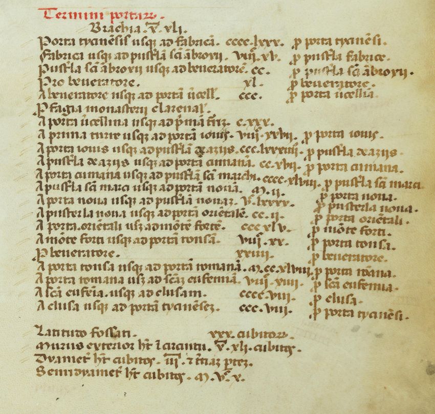
6                               Anna Pomierny-Wąsińska

played a decisive role in defining the city and its limits.2 Their image func-
tioned as a tool to imitate and resemble the Heavenly and Earthly
Jerusalem or Rome.3 The fortifications defined the boundaries of the reli-
gious community and, together with the nearby sacred places (loca sacra),
formed its defensive ring (murus protectionis). Their course was often
marked and commemorated in ritual processions performed to protect the
space inhabited by the urban community.4 Finally, the walls constituted
one of the most important communal goods (res publica) characterized by
utilitas publica — they belonged to the community as a whole and also set-
tled questions of membership in it.5
     The city gates were not only a link between those intra and extra mu-
ros, but also organized the space located inside the walls, establishing di-
visions into districts (portæ). Their physical location was also inextricably
related to the city centre and to the design of the pattern of the principal
streets. Due to their numerous functions, walls and gates were one of the
most important identifiers of specific places and provided a frame of ref-
erence for spatial orientation.
     The developing political and financial system in the late medieval
Italian city had a crucial role in controlling all activities involved in con-
structing city walls. The control and supervision covered, among other
things, concluding contracts for building individual sections of walls,6

mittelalterlichen Literatur bis zum Ende des Zwöelften Jahrhunderts, Hildesheim and New
York, 1980; Paolo Zanna, ‘Descriptiones urbium and Elegy in Latin and Vernaculars, in
the Early Middle Ages’, Studi Medievali, Ser. 3, 32, 1991, pp. 523–96; Elisa Occhipinti, ‘Im-
magini di città: Le laudes civitatum e le rappresentazioni dei centri urbani nell’Italia
settentrionale’, Società e storia, 14, 1991, pp. 23–52; Lucia Nuti, Cartografie senza le carte:
Lo spazio urbano descritto dal Medioevo al Rinascimento, Milan, 2008, pp. 36–54; 86–90;
Paul Oldfield, Urban Panegyric and the Transformation of the Medieval City, 1000–1300,
Oxford, 2019.
     2 Lucia Nuti, ‘Lo spazio urbano: realtà e rappresentazione’, in Arti e storia nel Me-

dioevo, ed. Enrico Castelnuovo and Giuseppe Sergi, 4 vols, Turin, 2002–04, vol. 1,
pp. 241–82.
     3 Chiara Frugoni, Una lontana città, Turin, 1983; Bianca Kühnel, From the Earthly to

the Heavenly Jerusalem: Representations of the Holy City in Christian Art of the First Millenni-
um, Rome, Freiburg and Vienna, 1987; Paul Zumthor, La Mésure du monde: Représenta-
tion de l’espace au Moyen Âge, Paris, 1993; Keith Lilley, City and Cosmos: The Medieval
World in Urban World, London, 2009.
     4 Silvia Mantini, ‘Un recinto di identificazione: le mura sacre della città’, Archivio

Storico Italiano, 153, 1995, pp. 211–61.
     5 Cf. Sara Menzinger, ‘Mura e identità civica in Italia e in Francia meridionale’, in

Cittadinanze medievali: Dinamiche di appartenenza a un corpo comunitario, ed. eadem,
Rome, 2017, pp. 65–111 (pp. 78–80).
     6 For the documentation containing contracts for the construction of sections of

the third ring of the Florentine walls, including gates, towers and sometimes their
sculptural decoration (which was, unfortunately, largely destroyed by the flood of

                                    http://rcin.org.pl
Measuring and Shaping the Late Medieval City 7
and making measurements,7 which was assigned to surveyors and the
master builders who accompanied them.8
Building fortifications was also one of the first impulses for the Ital-
ian communes to pursue the principle of proportionality in levying spe-
cial taxes from citizens who owned real estate in the city.9 For example,
in 1325, during the construction of the outermost ring of walls, which
continued for several decades, the Florentine authorities decided to im-
pose a special two-year property tax to help complete the construction
of fortifications in one of the districts.10 The amount depended mainly
on whether or not the property owned by a citizen had a façade looking
out onto one of the main streets of the city, and on the length of the
front wall of the building adjacent to the street. This regulation shows
the need for urban space to be rationalized by the use of measurement
tools due to the principle of just distribution of responsibilities for the
common good. Its effect was to ‘digitalize’ the city space, and to compile
measurement records and amounts of tax thus due.11 In the measuring
of urban space, the most important variable was the borderline between
1966, and for many years unavailable, but is now restored after conservation work),
see Florence, Archivio di Stato (hereinafter ASF), Capitani di Parte Guelfa, Numeri
Rossi 103.
7 For an earlier example of surveyor’s work in the construction of urban fortifi-
cations, although from another region of Europe (Flanders), see Lambert of Ardres,
Historia Comitum Ghisnensium, ed. Johannes Heller, in MGH SS, vol. 24, Hanover, 1878,
pp. 550–642 (p. 642).
8 For traces of measurements of the walls carried out in Florence, see ASF, Cor-
porazioni religiose soppresse dal governo francese 119, 607 (1323); 119, 839 (1323);
ASF, Corporazioni religiose soppresse da Pietro Leopoldo 508, 374 (1328); cf. Paula
Spilner, ‘Ut civitas amplietur: Studies in Florentine urban development, 1282–1400’,
PhD thesis, Columbia University, 1987, p. 208, n. 163; in smaller cities under Florentine
rule: ASF, Ufficiali delle Castella 11, c. 11v, 25r, 37r; see also: David Friedman, ‘Who De-
signed the Plan of the Florentine New Town of San Giovanni Valdarno (1299)’, Quader-
ni del Dipartimento Patrimonio Architettonico e Urbanistico, 37–40, 2009–10, pp. 21–34.
9 Regarding Italian and French cities, the most recent work on this subject is:
Menzinger, ‘Mura’, pp. 65–109.
10 ASF, Provvisioni Registri 22, fol. 39v (15 November 1325), see also: Carteggio in-
edito d’artisti dei secoli XIV, XV, XVI, ed. Giovanni Gaye, 3 vols, Florence, 1839–40, vol. 1,
p. 468; Franek Sznura, ‘Appunti sull’urbanistica fiorentina tra XIII e XIV secolo’, in Ar-
nolfo: Alle origini del Rinascimento fiorentino, ed. Lusanna E. Neri, Florence, 2005, pp. 86–97
(p. 89); for earlier examples of similar regulations in other cities, see Menzinger,
‘Mura’, pp. 67–68.
11 On ‘digitalization’ in the sense of ‘the transformation of forms or images into nu-
merical values’, see Emanuele Lugli, ‘A Mathematical Land: Measurements in Twelfth
and Thirteenth-Century Modena and the Po Valley’, in Was zählt: Ordnungsangebote, Ge-
brauchsformen und Erfahrungsmodalitäten des ‘numerus’ im Mittelalter, ed. Moritz Wedell,
Köln, 2012, pp. 275–93 (p. 292).
http://rcin.org.pl8 Anna Pomierny-Wąsińska
private and public space.12 These actions resulted in the compilation of
‘coded’ property maps, which not only included spatial information but
also categorized it, thereby valorizing the space, its elements and its
structures.
In essence, the system for supervising urban construction projects
and the search for a fair principle of participation in the financing of
public construction projects meant that the language of book-keeping
and measurement became tools commonly applied in describing urban
space. The fundamental example of its use is found in building regula-
tions.13 These regulations were known to the chroniclers, who used doc-
uments kept in municipal chancelleries. One should also not underesti-
mate the fact that the two key categories of rationalized description of
space — measurement and quantity — had long been present in Roman
catalogues and mirabilia, as well as in the descriptiones and laudes of oth-
er cities in late antiquity and the early Middle Ages.14 It was also for this
reason that late medieval chroniclers, familiar as they were with this
convention of describing urban space, so readily embraced and devel-
oped a numerical and measurement-based convention in their works.
The subject of the article is the analysis of the use of mathematical to-
ols in the literary descriptions of urbans space, conducted in relation to
selected passages of two historiographic sources. One text describes the
city walls of Florence, and originates from Giovanni Villani’s Nuova Croni-
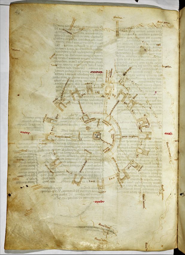
ca, while the other forms part of the much less studied Cronica extravagans
by Galvano Fiamma and describes the walls of Milan. Both works were
written in the 1330s and referred to fortifications built or reconstructed in
part during their authors’ lifetimes.15 Both authors used data from meas-
12 The most famous examples are libri terminorum from Bologna, that is, registers
of the boundaries between public and private space at key points of the city, see esp.
Jacques Heers, Espaces publics, espaces privés dans la ville: Le liber terminorum de Bologne
(1294), Paris, 1984; for more examples form Italian cities: Giampaolo Francesconi and
Francesco Salvestrini, ‘La scrittura del confine nell’Italia comunale: Modelli e funzio-
ni’, in Frontiers in the Middle Ages: Proceedings of the Third European Congress of Medieval
Studies, ed. Outi Merisalo, Louvain-la-Neuve, 2006, pp. 197–221.
13 Statuti urbanistici medievali di Lucca: Gli statuti delle vie e de’ pubblici di Lucca nei se-
coli XII–XIV: Curia del Fondaco: Statuto 1371, ed. Domenico Corsi, Venice, 1960; Guido
Pampaloni, Firenze al tempo di Dante: Documenti sull’urbanistica fiorentina, Rome, 1973;
Enrico Guidoni, Storia dell’urbanistica: Il Duecento, Rome, 1989, pp. 336–419.
14 See literature in n. 1, especially the work of Lucia Nuti, which emphasizes the
importance of the category of measure, and: Codice topografico della città di Roma, ed.
Roberto Valentini and Giuseppe Zucchetti, 4 vols, Rome, 1940–53, vol. 3, 1943,
pp. 77–110; Cristina Nardella, Il fascino di Roma nel Medioevo: Le ‘Meraviglie di Roma’ di
maestro Gregorio, Rome, 1997.
15 Giovanni Villani, Nuova Cronica, ed. Giuseppe Porta, 3 vols, Parma, 1990–91
http://rcin.org.plMeasuring and Shaping the Late Medieval City 9
urements of the walls in order to capture the size and magnificence of
their cities and by means of these data described the geometric features
of urban layouts to make it easier for the readers to visualize them.
II
Giovanni Villani described the outermost ring of the Florentine walls in
two chapters of Book 10 of his monumental Nuova Cronica.16 Unfortuna-
tely, this description often escapes researchers analysing the use of ac-
counting-related and quantitative tools in chronicles of late medieval cit-
ies. Their attention focuses primarily on the great numerical praise of
Florence relating to the years 1336–38, where Villani used quantities in his
description of the city’s citizens and their educational background, pro-
fessional groups, food production, buildings in and outside the city, and
so on.17 John Hyde, the author of a seminal study on the descriptions of
Italian cities, did not focus on the meaning or character of the description
of the walls analysed below; he rather vaguely justified its exclusion from
the numerical praise of the city saying that it was placed in an earlier part
of the chronicle.18 I find this explanation insufficient. The two fragments
(hereinafter Nuova cronica); La Cronaca estravagante di Galvano Fiamma, ed. Sante Am-
brogio Céngarle Parisi, Massimiliano David, intro. Paolo Chiesa, Milan, 2013 (hereinaf-
ter Cronica extravagans).
16 Nuova cronica, 10:256–57.
17 Ibid., 12:92–94; see Armando Sapori, ‘L’attendibilità di alcune testimonianze
cronistiche dell’economia medievale’, in idem, Studi di Storia economica medievale, Flor-
ence, 1940, pp. 127–35; Enrico Fiumi, ‘La demografia fiorentina nelle pagine di Giovan-
ni Villani’, Archivio Storico Italiano, 108, 1950, pp. 78–158; idem, ‘Economia e vita privata
dei fiorentini nelle rilevazioni statistiche di Giovanni Villani’, Archivio Storico Italiano,
111, 1953, pp. 207–41; Arsenio Frugoni, ‘G. Villani, Cronica, XI, 94’, Bullettino dell’Istituto
Storico Italiano per il Medioevo e Archivio Muratoriano, 77, 1965, pp. 229–55; cf. Edwin S.
Hunt, The Medieval Super-Companies: A Study of the Peruzzi Company of Florence, Cam-
bridge, 1994, pp. 268–71; these chapters of Villani’s chronicles are often compared
with the praise of Milan by Bonvesin de la Riva, in which quantity is the fundamental
category, Bonvesin de la Riva, Le meraviglie di Milano, ed. Paolo Chiesa, Milan, 2009
(hereinafter De magnalibus Mediolani).
18 Cf. Hyde, ‘Medieval Descriptions’, pp. 335–36; the mathematical character of the
description of the walls is not mentioned by Alexander Murray, Reason and Society in the
Middle Ages, Oxford, 1978, pp. 183–86; surprisingly, neither by Mantini, ‘Un recinto’ or
Charles T. Davis in ‘Topographical and Historical Propaganda in Early Florentine Chron-
icles and in Villani’, Medioevo e rinascimento, 2, 1988, pp. 33–51; Francesco Salvestrini
analyses it only in passing, idem, ‘Descrizioni e “laudes” a Firenze nel secolo XIV. Gio-
vanni Villani, la “Florentie urbis et reipublice descriptio”, Antonio Pucci, Lapo da Casti-
glionchio, Coluccio Salutati’, in Antica possessione con belli costumi, ed. Franek Sznura,
Florence, 2005, pp. 205–32 (p. 211). The state of research on Villani’s great description
of the walls has significantly changed in recent years owing to David Friedman, who
http://rcin.org.pl10 Anna Pomierny-Wąsińska
of the chronicle should not be linked, nor should they be treated as two
parts of the same praise of Florence. Nevertheless, both serve to create an
encomiastic image of the city and are proof of both authors’ adoption of
the same (that is, numerical) convention of describing the surroundings.
Giovanni Villani was a well-educated merchant;19 in the 1320s, he often
served as a member of the communal committees responsible for tax au-
dits and the management of municipal funds.20 For him, numbers and cal-
culations were the basic tools in understanding the quality of a thing or
issue in question, and therefore whenever he could make a reference to
a numerical value in his work he tried to do so.21 As shown by the numer-
ical praise of the city in Chapters 92–94 of Book 12, he did not refrain
from providing his own calculations and estimates; also, when not sure
about numbers or measures, he would simply leave a blank.22
It is worthwhile briefly characterizing the instances where Villani
used spatial measures. This will help to specify the areas in which meas-
uring was a useful tool in perceiving space, and a privileged feature of de-
scriptive cartography. The following analysis includes the presence of
units in Villani’s chronicle (the mile — miglia, the cubit — braccio or cubito,
and the measure — misura),23 but it is not my intention to identify his
sources of information. Villani used them primarily when he was design-
ing textual cartographies, discussing the location of a place based on the
distance from a chosen city (both in Tuscany and in faraway countries in
Europe and beyond).24 This use applies primarily to the mile, the largest,
supra-regional unit, which had been in use since Roman times.25 In many
of these cases, Villani was probably faithful to his sources and their con-
analysed in detail its characteristics and recognized its protocartographic features.
His article has been an important inspiration and a basis for the following considera-
tions: ‘Urban Design without Maps’, in Arnolfo’s Moment, ed. David FriedmanMargaret
Haines and Julian Gardner, Florence, 2009, pp. 161–81.
19 Ronald G. Witt, ‘What Did Giovannino Read and Write? Literacy in Early Renais-
sance Florence’, I Tatti studies, 6 1995, pp. 83–114; Franca Ragone, Giovanni Villani e i suoi
continuatori: La scrittura delle cronache a Firenze, Rome, 1998.
20 For the full curriculum of Villani’s offices, see Giovanni Aquilecchia, ‘Introdu-
zione’, in Cronica con le continuazioni di Matteo e Filippo, ed. idem, Turin, 1979, pp. X–XI.
21 Murray, Reason, p. 184.
22 Nuova cronica, 10:256–57; 13:46; cf. Arrigo Castellani, ‘Sulla tradizione della Nuo-
va cronica di Giovanni Villani’, Medioevo e rinascimento, 2, 1988, pp. 53–118 (p. 107).
23 Angelo Martini, Manuale di metrologia osia misure, pesi e monete, Turin, 1883,
pp. 206–11.
24 Nuova cronica, 2:1; 5:31; 7:6; 7:8; 7:46; 7:49; 8:7; 8:23; 8:28; 8:37; 8:87; 9:52; 12:26;
12:60; 13:84; 13:102; 13:111.
25 Villani uses the Roman mile when describing the borders of Tuscany: Nuova
cronica, 2:6; see also Odile Redon, ‘Une géographie de la Toscane chez un chroniqueur
du XIVe siècle, Giovanni Villani de Florence’, in eadem, Des forêts et des âmes: Espace et
http://rcin.org.plMeasuring and Shaping the Late Medieval City 11
ventional geographical descriptions.26 One of the most common situa-
tions where this unit was used was in reports from military operations
and descriptions of the movements of armies, which required an approxi-
mate image of the theatre of war to be portrayed, and the distances cov-
ered by troops to be estimated.27 For this type of textual cartography, the
category of distance was absolutely fundamental. In addition, it was remi-
niscent of the literary tradition of the Romans dealing with military cam-
paigns and the art of war. It is also worth noting here that, in this way,
Villani used the quintessential tool of travelling merchants to conjure an
idea of the world and its geographical description: merchants’ itineraries
providing information about the distances between successive points in
a journey.28
The above comments, however, do not exhaust all occurrences of
the mile in Nuova Cronica. It is also used in suburban areas as a category
for delimiting the legal boundaries that established restrictions and reg-
ulated the extent of granted privileges.29 The boundaries were based on
the centric principle, whereby the city was the centre of the territory in
question; from the centre of the city ran a radius defining the spaces
granted protection or privilege. For Villani, the concept of the mile was
so important in perceiving and determining the status of the territory
around the city that he devoted a separate chapter of his chronicle to
the place from which it was traditionally measured.30
Finally, in a few cases, the mile is used when the chronicler specifies
the length of the walls and tries to determine the size of the city described
by reference to its perimeter. This pertains not only to Florence,31 but also
to distant32 or ancient cities, biblical and mythical alike.33 With regard to
société dans la Toscane médiévale, ed. Laurence Moulinier-Brogi, Saint-Denis, 2008,
pp. 259–72.
26 On Villani’s sources, see Louis Green, Chronicle into History: An Essay on the Inter-
pretation of History in Florentine Fourteenth-Century Chronicles, New York, 1972, pp. 155–63;
Ragone, Giovanni Villani, pp. 13–21.
27 Nuova cronica, 8:49; 8:51; 8:70; 8:84; 8:87; 8:102; 8:117; 8:122; 8:124; 8:127; 8:140;
8:145; 9:55; 9:65; 9:78; 9:79; 9:119; 9:46; 9:48; 9:146; 9:175; 9:191; 10:296; 11:8; 11:49;
11:52; 11:153; 11:155; 11:211; 12:28; 12:52; 12:54; 12:64; 12:97; 12:131; 12:132; 12:140;
13:35; 13:59.
28 Cf. Alessandra Debanne, Lo Compasso de navegare, Brussels, 2011.
29 Nuova cronica, 4:3; 5:1; 6:13. This also applies to the rules of banishment from
the city: ibid., 10:219.
30 Villani points at the Florentine milliarium aureum, the statue of a lion next to
the Arno river flowing through the city, Nuova cronica, 5:33.
31 Ibid., 10:257.
32 Ibid., 9:58.
33 See the description of the Tower of Babel, ibid., 1:2; and of the walls of Troy,
ibid. 1:13.
http://rcin.org.pl12 Anna Pomierny-Wąsińska
ancient centres, measuring was a traditional and topical descriptive
tool: it helped in gaining an idea of the size of such places (be they fic-
tional or no longer existing) and invested them with a more real char-
acter, making it easier to conceptualize a representation of them.
Villani’s use of the cubit (braccio, braccio di calimala — approximately
58.3 cm, the basic unit of measure used in Florence) presents a separate is-
sue. The chronicler uses this particular unit when mentioning the number
and height of the towers belonging to the Guelphs and Ghibellines during
the struggles between them in the first half of the thirteenth century.34
Then, as the consequence, he also provides the figure of the maximum
height of a tower as stipulated by laws established by communal authori-
ties in the mid-thirteenth century. This remark, incidentally, is an exam-
ple of the use of measuring as a tool of control in Italian cities.35 Passages
such as these are particularly significant, emphasizing as they do the ver-
tical dimension of urban space — the height of the buildings and, conse-
quently, the cityscape as seen from afar. Villani himself draws attention to
this, when he writes about the supposed restoration of Florence by Charle-
magne: ‘within the little city there were in a short time more than 150
towers pertaining to citizens, and each one 120 cubits high, without count-
ing those pertaining to the city; and by reason of the height of the many
towers which then were in Florence, it is said, that it showed forth from
afar as the most beautiful and proudest city of its small size which could be
found.’36 Thus, the number of the towers and their height are here the fun-
damental categories used in shaping the image of the city in the past.
It can be hypothesized that the cubit served Villani to describe space
when he tried to create an image of the urban space and its buildings con-
trolled by the commune of Florence. These descriptions include references
to buildings or construction projects in Florence and in its outer territo-
ries.37 This is due to the sources used by the author, namely the documen-
34 Ibid., 6:9; 7:33; for other example of the height of city buildings, see ibid., 7:5.
35 Nuova cronica, 7:39 and Statuti della repubblica fiorentina, ed. Giuliano Pinto, Fran-
cesco Salvestrini and Andrea Zorzi, 2 vols, Florence, 1999, vol. 2: Statuto del podestà
dell’anno 1325, 4:41, p. 305; see also John M. Najemy, ‘Florentine Politics and Urban
Spaces’, in Renaissance Florence: A Social History, ed. Roger J. Crum, John T. Paoletti, New
York, 2006, pp. 19–54 (p. 24); Nuti, Cartografie, pp. 69–82; eadem, Lo spazio urbano,
pp. 260–63.
36 Nuova cronica, 4:3; Eng. transl. after: Villani’s Chronicle Being Selections from the
First Nine Books of the Croniche Fiorentine of Giovanni Villani, transl. Rose E. Selfe, ed. Phil-
ip H. Wicksteed, London, 1906, p. 67.
37 See also descriptions of the Roman parlagio in Florence, which were no longer
existent in Villani’s time: Nuova cronica, 1:36; of a Tuscan aqueduct: ibid., 2:1; of work
on the restoration of city bridges: ibid., 13:46.
http://rcin.org.plMeasuring and Shaping the Late Medieval City 13
tation produced by the commune and the legal regulations from which
Villani drew information for his chronicle, at times using them as a pre-
text for describing major urban projects. Measurement and calculation
are of fundamental importance in these sources due to the technical and
financial nature of their subject matter. It is also important that most of
these cases concern projects related to the construction of walls, that is,
the elements of public space which enjoyed particular protection under
municipal law.38
The cubit also appears several times in the chapter on the great flood
of 1333 in Florence.39 There, Villani describes in detail the water levels in
various parts of the city; the braccio is applied to identify the sections of
walls destroyed by the flood and the changes that had taken place in the
Arno riverbed. It is possible that some information contained in that chap-
ter was drawn from the documentation drafted by communal officials who
estimated the magnitude of damages. The flood of 1333 and its causes were
subject to detailed and long debates.40 Perhaps because of these heated dis-
cussions, Villani tried to make his description as rational and objective as
possible with regard to the losses sustained. In addition to that, as was the
case with buildings and urban layouts that were difficult to imagine on ac-
count of their sheer size, the chronicler undoubtedly referred to measure-
ments for rhetorical effect, and specifically to emphasize the scale of the
calamity.
III
The chapters of Nuova Cronica devoted to the outermost ring of walls
are exceptionally rich in numerical detail compared to all other parts of
the work.41 They were written in the 1330s42 and refer to the state of af-
fairs as of 1324, when the chronicler was the official responsible for their
38 Descriptions of erecting Florentine wall rings: ibid. 2:1; 10:10; 10:137; 10:256–57;
in a city subordinate to Florence: 13:82; cf. David Friedman, ‘The Porta A Faenza and
the Last Circle of the Walls of Florence’, in Essays Presented to Myron P. Gilmore, ed. Ser-
gio Bertelli and Gloria Ramakus, 2 vols, Florence, 1978, vol. 2, pp. 179–92.
39 Nuova cronica, 12:1; similarly in the case of descriptions of other natural disas-
ters: 12:22; 13:123.
40 Ibid., 2:2; on the subject of the flooding and accounts about it, see Gerrit J.
Schenk, ‘L’alluvione del 1333: Discorsi sopra un disastro naturale nella Firenze medie-
vale’, Medioevo e rinascimento, 21/n.s. 18, 2007, pp. 27–54; Francesco Salvestrini, ‘L’Arno
e l’alluvione fiorentina del 1333’, in Le calamità ambientali nel tardo medioevo europeo,
ed. Michael Matheus et al., Florence, 2010, pp. 231–56.
41 Nuova cronica, 10:256–57.
42 See Green, Chronicle, pp. 164–69.
http://rcin.org.pl14 Anna Pomierny-Wąsińska
construction.43 Villani emphasizes that exercising his official capacity he
ordered that detailed measurements of the walls should be made. He also
presents the reason for including information from this mensuratio in the
chronicle, that being to commemorate the magnitude of Florence and
present it in an accessible manner to readers from outside the city.44
This intention stems from the topical motivation of Villani in writ-
ing his chronicle and is also one of the characteristic features of laudes
civitatum. It is not without significance that in striving to achieve this
goal Villani chooses measurement as an aspect of description to facili-
tate the creation of an image of the city. The references to detailed
measurements contained in his work may also betray another of the
author’s motives, albeit not an openly stated one. In the early 1330s,
when serving as the treasurer of the construction of new walls, Gio-
vanni Villani was accused of embezzlement.45 The long and detailed de-
scription may be related to this accusation as an attempt to counter
these allegations and underline the author’s competence in his execu-
tion of his office.
When analysing the literary representation of space, it is worth noting
that Villani introduces elements characteristic of laudes civitatum into the
description of the Florentine walls, and that he structures these chapters
in keeping with the conventions of that literary genre. They fit into the tra-
ditionally included part devoted to presenting the location (locus et situs)
together with remarks concerning the fortifications (moenium).46 This is
also confirmed in the conclusion of the description, where the chronicler
marks the transition back to the principal matter of his work.47 In the final
43 On ufficiali delle mura, numbers, term and competence, see Statuti della repubblica
fiorentina, vol. 1: Statuto del capitano del popolo degli annni 1322–1325, 5:129, pp. 288–90; cf.
Spilner, Ut civitas, pp. 150–59. The documentation of the construction of the walls
mentions Villani as an official only once, just under 1324, see ASF, Capitani di Parte
Guelfa, Numeri Rossi 103, fol. 30. The chronicler also mentions the performance of the
function when describing earlier events from January 1322: Nuova cronica, 10:137. At
that time he was one of the priori, the highest ranking municipal officials, (15 Febru-
ary 1321–15 February 1322), new decisions regarding the walls were made during this
term. For the stages of building the fortifications, see Renzo Manetti, Maria Chiara
Pozzana, Firenze, le porte dell’ultima cerchia di mura, Florence, 1979, pp. 63–90; Spilner, Ut
civitas, pp. 116–50.
44 Nuova cronica, 10:256.
45 Researchers associate the crisis of his administrative and political career with
this event, see: Aquilecchia, ‘Introduzione’, pp. X–XI; Hunt, The Medieval Super-Compa-
nies, p. 269.
46 ‘De laudibus urbium’, in Rhetores Latini minores, ed. Carolus Halm, Leipzig, 1863,
pp. 587–88.
47 ‘Lasceremo omai del sito de la cittade di Firenze, ch’assai n’avemo detto, e tor-
neremo a nostra materia’, Nuova cronica, 10:257.
http://rcin.org.plMeasuring and Shaping the Late Medieval City 15
part one can also find other elements characteristic of the genre. They in-
clude selective and conventional enumeration of specific elements of the
urban space: in this case, references are made to the bridges on the Arno
River48 and the loca sacra which, according to Villani’s account, numbered
over a hundred (‘not including hospitals, churches and monasteries lo-
cated near the gates’).49
The above elements frame the image designed by Villani, although
the main part of his description comprises measurements of walls and
calculations carried out based upon them.50 Two elements — mensuratio
and laudatio — are complementary here and serve each other; laudatio
defines the framework of the description, while mensuratio is its content.
The first of two chapters dedicated to the walls is devoted to the charac-
teristics of walls on the northern side of the city (five out of six districts,
sestieri), and the second to the fortifications of the district south of the
river (Oltrarno). We are thus presented with two separate descriptions
and measurements, the author himself emphasizing that Oltrarno may
have been regarded as a city in its own right.51
Villani begins the first chapter from the easternmost point: a sixty-
-cubit-high tower built in the location designated for the construction of
the Ponte Reale.52 Then, he lists the next twelve sections, which in most
cases are marked by gates.53 While determining these points, he also in-
dicates the width and height of the buildings. Thus, the representation of
the city provided by Villani is not two-, but three-dimensional. While re-
ferring to the sections, the chronicler always specifies not only their ex-
tremities, but also the number of towers that formed part of the given
section. The enumeratio of these sections is listed in a continuous manner
and appears to have been copied from the accounting books. The phrases
specifying the distance — ‘from’ (da la porta) … ‘to’ (a la porta) … ‘is/meas-
ures’ … (si ha [misura]) — are characteristic of mensurationes, and there is
48 Villani lists four stone bridges, in order from east to west: Rubaconte, Vecchio,
Santa Trinita and de la Carraia. The chronicler also mentions the unbuilt, though
planned, easternmost Ponte Reale, cf. also ibid., 10:83. Significantly, Villani writes
about bridges as permanent elements of space, despite the destructions associated
with the 1333 flood; he writes these words, however, probably already after the flood,
as evidenced by the mention of the consequences of flooding in the Oltrarno district.
49 Nuova cronica, 10:257.
50 The numerical praise of the city in Book XII is also written into this frame-
work, ibid., 12:94.
51 Ibid., 10:257.
52 On Ponte Reale see above n. 48; in the municipal statutes it functions under the
name Pons Popularis, Statuti della repubblica fiorentina, vol. 1, 5:81, p. 261.
53 In two cases, these are large towers in walls, in one case — the Arno river, Nuo-
va cronica, 10:256.
http://rcin.org.pl16 Anna Pomierny-Wąsińska
no doubt that this part of the description was drawn from a document
certifying the mensuratio.
In the second part of the chapter, the author summarizes the measure-
ments and makes further calculations. He points out that the dimensions
mentioned earlier make it possible to determine the ‘space’ of districts lo-
cated north of the river.54 He sums up all the sections of the walls (7,700
cubits)55, gates (nine, including four main gates — porte mastre — and five
smaller ones known as postierle) and towers (forty-five).56 He also specifies
the distance between the two extremities of the fortifications (4,500 cubits
or 1.5 miles), although they did not constitute the city boundary. This re-
mark explains the legitimacy of including this piece of data, as it helps Vil-
lani describe the circular shape of the city. He does not use the term ‘dia-
meter’, but this term captures the role of that particular section. It is clear,
therefore, that Villani not only uses the language of measure to give an
idea of the size of the city, but also uses geometric imagination to verbally
represent its form. This is also confirmed by the detailed calculations car-
ried out by David Friedman.57 The image conjured up by the chronicler
consists in the description of the boundary (the sections of the walls) and
his attempt to determine the geometric data defining the form of the city
that would correspond to the archetypal circular representation.
The description of fortifications on the southern side of the river from
the next chapter (257) follows the same structure: Villani first gives a list
of sections and, afterwards, formulates certain conclusions. Some infor-
mation about this part of the city appears as early as in the first chapter of
the description concerned with the length of the section along the river.
The chronicler leaves a blank when referring to this section, but he points
out that it is shorter than the one on the other bank. This empty space
marks a significant difference in the character of the chapters. While the
first chapter, concerning the northern part of the city, presents orderly
arranged and detailed measurements, the other lacks information on the
number of towers and the specified sections are often longer than those
north of the river. This may be due to several factors. First of all, Villani
himself points out that the construction of the walls in the district of Ol-
54 ‘E così troviamo che ’l detto spazio de le cinque sestora de la città di Firenze,
a le nuove cerchia di mura, sono […],’ ibid.
55 Villani slightly rounds up the final result; according to my calculations, the to-
tal length of the sections is 7,696 cubits. Friedman gives a different number of 7,796
cubits. Interestingly, it appears that the figure 7,696 better reflects the calculations
carried out by Friedman with the use of Google Earth, emphasizing as they do the ac-
curacy of the measurements provided by Villani, cf. Friedman, ‘Urban Design’, p. 165.
56 Nuova cronica, 10:256.
57 Friedman, ‘Urban Design’, pp. 165–67.
http://rcin.org.plMeasuring and Shaping the Late Medieval City 17
trarno began in 1324: when he was the official responsible for that project
and had access to project documentation, the fortifications had not yet
been completed. Villani could not, therefore, avail himself of measure-
ments as detailed as those pertaining to the northern part of the city; he
could, however, have known the details of the project in progress, such as
the approximate length of the planned sections. What we also know is
that the task assigned to Villani in his official capacity was to supervise
the construction of the walls in the southern part of the city.58 The de-
scription itself, however, was created or reworked by the author after the
great flood of 1333,59 when the walls had already been largely completed
(although work on the remaining sections and the San Niccolò gate con-
tinued for almost two decades).60 It should also be noted that the southern
walls were built on undulating terrain. Therefore, the hilly character of
that district made it difficult to carry out systematic measurements; it was
also a much less developed and less urbanized periphery of the city com-
pared to parts adjacent to the walls in the northern part. This observation
is also confirmed by the fact that the chronicler describes the first part of
the Oltrarno wall in more detail (the section of wall leading from the west-
ern part of the city to the Boboli Gardens, where the wall turns towards
the hill), mentioning in the final part of the text that the walls at the gate
of San Niccolò were unfinished.61 Villani completes his survey in the place
where he began, that is, at the planned but never-built Ponte Reale.
Chapter 257 also includes a summary of the mensuratio. Villani pro-
vides the number of gates and again tries to determine the width of the
Arno River. He leaves a blank space to be filled with the total length of the
sections, but gives an approximate calculation in miles (5 miles). However,
this list is richer in detail than the one devoted to the northern part of the
city since its purpose is to summarize the descriptions of the walls on both
sides of the river. It also provides us with more detail about the represen-
tation produced by Villani and about the tools he used in the process.
Moreover, it is also in this chapter that the chronicler gives the following
figures: the width of the moat on either side of the Arno (35 and 30 cubits)
and the width of the streets around the fortifications (inside and outside
of the wall, 16 cubits); the thickness of the walls (3.5 and 3 cubits) and
58 The author emphasizes his own achievements (the erection of the gate and
tower at the Camaldoli church); elsewhere, he is critical of the construction of the
wall leading to Porta Romana, alluding that blame should be placed on the officials
responsible for that building project, Nuova cronica, 10:257.
59 Ibid.
60 Manetti, Pozzana, Firenze, pp. 89.
61 Nuova cronica, 10:257; see also Friedman, ‘Urban Design’, p. 165.
http://rcin.org.pl18 Anna Pomierny-Wąsińska
their height (20 cubits). Thus, we find here the characteristic, almost
topical elements of medieval descriptions of fortifications (moenium) —
their height and width — which emphasized their qualitas. However, the
data is much more detailed owing to the personal involvement of the
author in the project and to the documentation accessible to him, and
his merchantly meticulousness over numbers and measures.
This fragment of the chronicle concludes with two notes concerning
the walled enclosure.62 Villani uses there the verb girare and the nominal
derivative giro, both referring to the circle. The chronicler uses this term
also in his previous descriptions, which underlines the subconscious as-
sociation of the term with the ring of walls.63 This association functioned
on the level of language; when used on its own, void of geometric expla-
nations, it need not have indicated that the city was regular in shape.64 It
is also worth noting here that the term giro may also refer to walking
along the walls and carrying out the measurement of city boundaries.
Villani reconstructs the route, providing the lengths of the sections di-
vided by towers and gates, crosses the river by the Ponte alla Carraia and
walks into the other part of the city; there, his calculations become con-
fused since the hilly terrain is difficult to measure. Finally, he returns to
the place where he began. This description is of an extremely practical
value, because it illustrates that Villani clearly used the documentation
produced by surveyors and that he also availed himself of his own imagi-
nation, firmly based on his familiarity with the subject of the description.
This ‘experience of space’ is an extremely important element in shaping
the representations of urban space.
The figures above present only part of Villani’s calculations. When
writing about the walled enclosure, Villani gives the circumference as
14,250 cubits, which he then converts to miles (approximately 5, in keep-
ing with the local convention: 3,000 cubits = 1 mile).65 Having determined
62 ‘E tanto gira la cittade dentro, cioè le mura sanza i fossi e le vie di fuori […].
E così gira la nostra città di Firenze migliaia XIIII, e CCL braccia’, Nuova cronica, 10:257;
see also Dante Alighieri, Paradiso, c. 30:130: ‘vedi nostra città quant’ ella gira.’
63 Nuova cronica, 2:1; 4:2; 5:7; 8:145; 9:58; see also the description of Tuscany, ibid., 2:6.
64 Cf. Friedman, ‘Urban Design’, pp. 165–66; cf. also anonymous, Latin praise Flo-
rentie urbis descriptio, written at almost the same time as Villani’s Nuova Cronica, where
the vernacular term giro is used instead of the Latin circuitus, ‘Florentie Urbis et Rei-
publice Descriptioi, in Carl Frey, Die Loggia dei Lanzi zu Florenz, Berlin, 1885, pp. 119–123;
cf. Salvestrini, ‘Descrizioni’, pp. 212–19. All the quoted cases reinforce the belief that
the giro delle mura means, above all, the ring or circuit of the walls.
65 As noted by Friedman ‘a circle of 14,250 braccia around has a diameter of 4,534
braccia’ (‘Urban Design’, p. 166), which is in line with the conclusions presented in
Chap. 256. In the light of Friedman’s calculations, the walled circumference is approx-
imately 14,290 cubits.
http://rcin.org.plMeasuring and Shaping the Late Medieval City 19
the boundary of the city with a measure, he directs his attention towards
its interior and the fundamental principles of its layout. He emphasizes
that while measuring the walls he also ordered that a measurement be
made of the ‘cross of the city’ (croce de la detta città) that was marked by the
streets leading through the four most important gates: from east to west
(from the Santa Croce gate to the Prato gate, 4,350 cubits) and from north
to south (from the gate of San Gallo to the Porta Romana, 5,000 cubits).
Thus, Villani introduces yet another basic element in the description of
the city’s layout by identifying the two axes of the city corresponding to
cardo and decumanus as defined by the Romans.66 This is certainly an ap-
proximative and conventional approach, as the axes he points out do not
consist of equal or consistently oriented sections. This image is comple-
mented by the final element of the city’s form: the designation of its cen-
tre. The measurements quoted by Villani indicate that it was the Mercato
Vecchio, the forum of Florence in the Roman period and the most impor-
tant economic centre of the city in the Middle Ages. The author gives the
dimensions of the sections running from the four gates marking the cross
of the city to that central place, which also attests to the permanence of
Roman measuring tradition and practice.67 Having determined the mathe-
matical relationship between the city centre and its peripheries, Villani
also indicates a specific place which in his view is both the point of inter-
section between the two axes and the centre of the circle of fortifications.68
66 This is a consequence of systems created by ancient surveyors’ practices delim-
iting the boundaries of newly founded cities on the basis of two main axes, and the
close relationship between the manner of presenting the medieval city and Christian
cosmology, cf. Oswald A.W. Dilke, ‘Maps in the Treatises of Roman Land Surveyors’,
The Geographical Journal, 127, 1961, pp. 417–26; idem, ‘Maps in the Service of the State:
Roman Cartography to the End of Augustan Era’, in The History of Cartography, 6 vols,
Chicago, 1987–2019, vol. 1, ed. John B. Harley and David Woodward, pp. 201–11; Joseph
Rykwert, The Idea of a Town: The Anthropology of Urban Form in Rome, Italy and the Ancient
World, Cambridge, MA, 1988; for a survey of literature on ancient agrimensura, cf. Brian
Campbell, The Writings of the Roman Land Surveyors: Introduction, Text, Translation and
Commentary, London, 2000.
67 Villani gives the length of the three equal limbs of the cross (2,200 cubits), and
the length of the longer one leading from the Mercato Vecchio to the south (2,800 cu-
bits). Friedman acknowledges ‘an artificial symmetry that structures the internal
form of the city and by giving a rational dimension to the longer, southern limb they
[the figures] also impart a spiritually symbolic character to this particular cross’. It
seems to me that this reference to Christian symbolism is an overstatement; in my
opinion it is more important to emphasize the importance of creating a geometric
image of the city with its geometric centre and regular urban layout, cf. Friedman,
‘Urban Design’, p. 167.
68 ‘ ’l punto della croce e del centro del giro della cittade si ha in su la Calimala,
quasi ov’è oggi la casa de’ consoli dell’arte de la lana, ch’è tra Calimala e la piazza
e loggia d’Orto Sammichele.’ Nuova cronica, 10:257.
http://rcin.org.pl20 Anna Pomierny-Wąsińska
This indication marks the pivotal point of his geometrized and rational-
ized vision of space and appears alongside other elements characteristic of
laudes civitatum, namely a selective enumeratio of elements of space within
the walls, with which the description of the location of Florence ends.
The structure of both chapters reflects mensurationes, which primar-
ily included the measurement of all sides of the delimited area (usually
four sides, but this depended on the terrain, which was never defined by
referring to a specific geometrical figure) and, secondly, the calculations
of the size of the area in question. In the mensurationes related to sales or
taxes, spatial measurements were sometimes accompanied by the pro-
cedure known as estimationes, that is, valuations carried out by survey-
ors, accountants or other officials specially designated for this purpose.
Sources of this kind are rare, but are sometimes preserved in the docu-
mentation of individual building projects or in the archives of munici-
pal offices and church institutions.69 The exceptions are the libri termino-
rum70 and detailed tax documentation.71 The available sources usually
include information that the mensuratio had been made and paid for,
and the final calculations (the size of the area determined in the meas-
urement unit adopted by the city and the value of a given property).
Thus, Villani’s text proves to be even more important, enriching as it
does our knowledge from a small number of sources.
Retaining the structure of the measurement allowed Villani to sup-
ply numerical data and present their interpretation as an idealized im-
age of the city. In the summary of the first chapter, Villani presents
Florence built on the diameter of the circle marked by the river flow-
ing through the middle of the city; in the summary of the other chap-
ter, he refers to the image of the city functioning in culture, which was
based on a circle, a cross of streets, and a conspicuous centre. This ide-
alization should be treated as a way of perceiving space through geo-
metrization, making it easier to comprehend and refer to known ar-
chetypes.72 The pieces of information presented in the two chapters
69 For examples of mensurationes in the vernacular, see ASF, Corporazioni religiose
soppresse dal governo francese, serie 86: S. Maria degli Angeli, 64, fols 12r–16r,
17r–30v; ASF, Ospedale di San Matteo, 1, fols 15r–16r, 27r–28v.
70 Francesconi, Salvestrini, ‘La scrittura del confine’.
71 On measuring practices of land in the Middle Ages and mensurationes per-
formed for the fiscal needs: Arnelle Querrien, ‘Techniques et pratiques de la mesure
du sol’, in La terre: Connaissance, représentations, mesure au Moyen Âge, ed. Patrick Gautier
Dalché, Turnhout, 2013, pp. 625–72; De l’estime au cadastre en Europe: Le Moyen Âge,
ed. Albert Rigaudière, Paris, 2006.
72 Evgeny A. Zaitsev, ‘The Meaning of Early Medieval Geometry: From Euclid and
Surveyors’ Manuals to Christian Philosophy’, Isis, 90, 1999, pp. 522–55.
http://rcin.org.plMeasuring and Shaping the Late Medieval City 21
containing the description of walls complement one another in a strik-
ingly evident manner.
The use of written mensurationes is attested not only on the level of
the text’s structure, but also in the terminology used in it. Villani refers
several times to the concept of the border (frontiera) when writing about
a section of city walls. Summarizing the description of the northern part
of the city, he also uses the verb determinare,73 which should be associat-
ed with the Latin terminare, defining the basic activity of surveyors, that
is, setting boundary points and measuring the distance between them.
Together with the description of the city’s form, this particular element
of the lexical plane of the text confirms the importance of the tradition-
al art of measuring in conceptualizing urban space.
A specific feature of the language used by Villani is the expressions
characteristic of exercises in abacus schools, especially in parts in which
the chronicler presents a summary of measurements and ensuing calcu-
lations.74 In the discussed period, the language of mathematical proof was
still predominantly descriptive, lacking the symbols and signs known to
the modern reader; one of the superior features of that language was its
vernacular character. Textbooks of practical mathematics also, and fairly
often at that, included examples referring to buildings, that is, the heights
of towers, the distances between them, and so on.75 Interestingly, how-
ever, Villani does not use such terms as ‘radius’ and ‘diameter’ when indi-
cating the form of the city.
The measure and geometric characteristics of Villani’s descrip-
tion described above should be complemented with comments on is-
sues related to naming and the manner of orientation which enrich his
rationalized description of space. The function of boundary marks (ter-
mini) in this description is undoubtedly assigned to gates and towers.
The chronicler pays particular attention to their naming, often provid-
ing two names used at the time and their possible origin. These names
constitute here the basic elements of urban toponymy. In many cases,
73 ‘Avemo diterminata la città di qua dal fiume d’Arno’, Nuova cronica, 10:256.
74 ‘E così troviamo’; ‘la ritondità de la città e cricuito pigliamo solamente a la lati-
tudine’; ‘compitando la detta porta e la detta torre coll’altre.’; ‘quando fieno compiu-
te’, ibid., 10:256–57.
75 The prime example is the pioneering textbooks written by Leonardo da Pisa
(known as Fibonacci, active in the first half of the thirteenth century); for a list of
Italian abacus treatises, see Warren Van Egmond, Practical Mathematics in the Italian Re-
naissance: A Catalog of Italian Abbacus Manuscripts and Printed Books to 1600, Florence,
1981; on teaching practical mathematics, see Robert Black, Education and Society in
Florentine Tuscany, Teachers, Pupils and Schools, c. 1250–1500, Leiden and Boston, 2007.
http://rcin.org.pl22 Anna Pomierny-Wąsińska
while referring to a specific gate, Villani also determines the destina-
tion to which the respective road led.
However, this is not the only means of orientation and localization
used by Villani. The description of the walls in Nuova Cronica is largely in-
novative in the author’s use of the names of winds to determine their
course.76 What this means is that the list of sections does not consist only of
the names and measures, but also information about the point at which the
walls turn;77 ‘with what wind’ they run or to what wind they are exposed.
Villani does not use the mathematical concept of angle (in the chronicle he
does this only with regard to astronomical phenomena),78 which is not sur-
prising, since determining angles did not form part of surveying practice.
The sides of the delimited area were always determined by surveyors with
reference to the cardinal directions, although their names frequently de-
pended on practices adopted in the region.79 The use of names of winds
seems to be Villani’s original idea. That idea also makes it possible to estab-
lish a connection between his representations and a portolan chart, in
which the Rose of the Winds was used to present a meticulous outline of
sea shores to facilitate navigation.80 It may seem to the reader of Villani’s
account that his description of the walls was based on a similar method in
76 Cf. Friedman, ‘Urban Design’, pp. 167–68. The names of winds used by Villani
are: Mezzogiorno, Scirocco, Levante, Tramontana, Maestrale, Ponente; some of these names
were also used to describe the cardinal directions, see for example, Nuova cronica, 2:6.
77 Villani uses the words gombito/gomito (elbow, colloquially: a turn) or angolo (angle).
78 Nuova cronica, 2:13; 4:1; 12:2; 13:8; 13:41; 13:141. It is worth mentioning that the
terminology of winds also played an important role in orientation in the sky; Villani’s
proficiency in astrology was recently studied by Robert Hand, ‘Giovanni Villani and
the Great Conjunction of 1345’, in Astrologers and their Clients in Medieval and Early Mod-
ern Europe, ed. Wiebke Deimann and David Juste, Cologne, 2015, pp. 63–82.
79 In Florence, these were: oriens, meridies, occidens, septentrio; in Milan, they were
related to the time of day: a mane, a meridie, a sero, a monte. For examples from Flor-
ence see: Pampaloni, Firenze; for Milan: Paolo Grillo, ‘L’introduzione dell’estimo e la
politica fiscale del Comune di Milano alla metà del secolo XIII (1240–1260)’, in Politiche
finanziarie e fiscali nell’Italia settentrionale (secoli XIII–XV), ed. Patrizia Mainoni, Milan,
2001, pp. 26–27. The use of the cardinal directions was a distinct feature of measure-
ment description distinguishing it from the notarial description, where the sides
were identified by references to the identity of the owners of the neighbouring prop-
erty, although it has to be said that the measurement and notarial patterns of de-
scription were closely related, see Luciano Lagazzi, Segni sulla terra: Determinazione dei
confini e percezione dello spazio nell’alto Medioevo, Bologna, 1991.
80 Tony Campbell, ‘Portolan Charts from the Late Thirteenth Century to 1500’, in
The History of Cartography, vol. 1, pp. 371–463; Patrick Gautier Dalché, Carte marine et
portulan au XIIe siècle: Le ‘Liber de existencia riveriarum et forma maris nostri mediterranei’
(Pise, circa 1200), Rome, 1995. Victoria Morse, ‘The Role of Maps in Later Medieval Soci-
ety: Twelfth to Fourteenth Century’, in The History of Cartography, vol. 3, part 1, ed. Da-
vid Woodward, 2007, pp. 25–52.
http://rcin.org.plYou can also read