MARINE ZONES AND HABITATS IN IRELAND - Clean Coasts
←
→
Page content transcription
If your browser does not render page correctly, please read the page content below
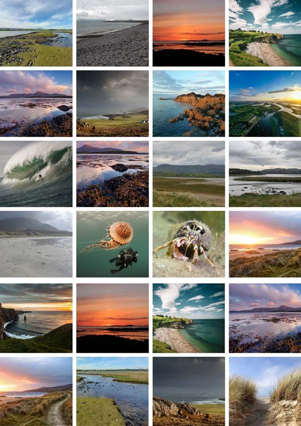
MARINE ZONES AND HABITATS IN IRELAND
Marine Zones & Habitats
Image by Maciej Staroniewicz
Our coastline and oceans are made up of many types of zones and habitats. The zone we are most likely to encounter
is the coastal zone, the area of transition between land and sea. Moving seaward past the coastal zone brings us to the
intertidal zone, this is the area of seashore between the high and low tide. From there past the low tide line out to the
continental shelf you will find the subtidal zone, and then you will encounter oceanic zones to the deepest parts of the
ocean.
Within these zones exists a myriad of habitats and fascinating species. These habitats are some of the most complex
and dynamic on earth and range from being fully emersed to fully submerged depending on their proximity to the
shoreline. The dynamic nature of the ocean means in order to survive, species must adapt to changing levels in light,
temperature, salinity, oxygen and pressure.
Let’s explore these zones and habitats a little further, from above the high tide line right out to the edge of the conti-
nental shelf. The following habitat classifications are based on ‘A Guide to Habitats in Ireland’ (Fossitt, 2000).
Coastal Zones Intertidal Zones
Subtidal Zones Marine Water Body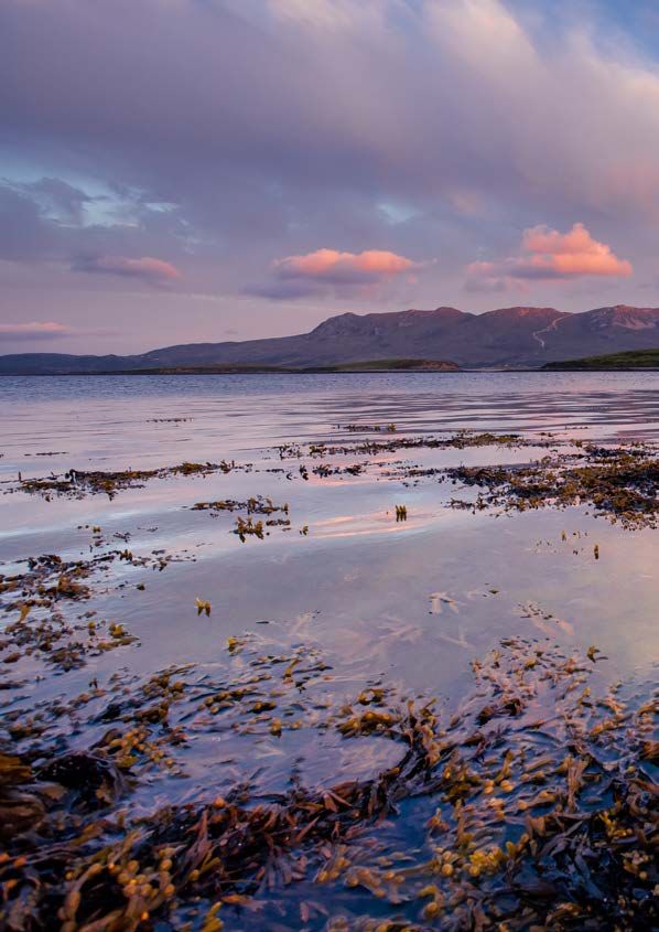
COASTAL ZONE
Coastal Zone
Image by Githin Tom Zachariah
Coastal Zones are transition zones between land and sea. The habitats in this zone are usually found above the high
tide line, however, sometimes they occur within the intertidal zone if terrestrial vegetation is present. These habitats
rely heavily on marine influences such as the salty sea air.
This zone is where most people interact with the ocean, it generates livelihoods and has a strong recreational value.
Visiting and living beside the coast can also have positive effects on general health, mental health and wellbeing.
However, the desire to visit, work and live in coastal areas puts incredible pressure on this environment. If care is not
taken to deal appropriately with these pressures, areas can become littered, polluted, eroded and result in a casualty
of over-development. We can all make a difference by learning about and looking after the coastal areas we love.
Habitats found in this zone include:
Dunes Machair Sea cliffs Salt Marsh Lagoons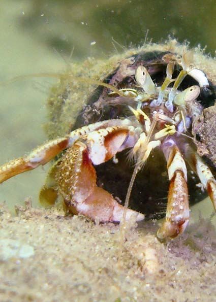
Coastal Zone Habitat
    S and D unes

                                                                         Ima ge by Edel Cunningham

Ireland’s sand dune systems have been developing for around 5,000 years. The sand originates from
glacial deposits that over time have been shaped by the tide and wind to create dunes. During this
cyclical process, sand is transferred between dunes, adjoining beaches and offshore sandbanks. This
process results in dynamic landforms that are continually changing through erosion and accretion.

Coastal Dunes also include important habitats for many rare plants, insects and ground nesting birds.
These habitats and species are protected by EU law under the Habitats and Birds Directives. Some of
these habitats are noted as priority habitats, meaning they are at risk of disappearing.

Dune Erosion
From a human perspective, dunes offer natural protection against high seas and storm surges. In
recent times erosion has accelerated due to factors relating to climate change, i.e., increased storm force
and rising sea levels. These events can cause sand to blow inland and result flooding if the dune area is
breached. Therefore, it is important to be aware of their fragility and ever-changing state if developing
beside them.

Our interaction with coastal dunes is also exacerbating erosion. One major issue is the removal of sand
from beaches. Coastal sand is, for the most part, a finite resource. Its depletion impedes on the
further development of dunes and nourishment of our beaches.

Other activities putting dune systems at risk are over-grazing, trampling, hard engineering and fires.

                    Ima ge by Ol ivia Jones                                Ima ge by Ol ivia Jones

         Embryonic dunes in Co. Donegal                       Trampled dunes caused by beach visitors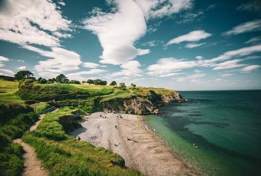
Coastal Zone Habitat
    S and D unes

                                                                       Ima ge by Edel Cunningham

Coastal Dunes contain important habitats for rare plants, insects and ground nesting birds that are
protected by EU law under the Habitats and Birds Directives.

A well-established dunes system should consist of the following habitats:

Embryonic Dunes are the early stages of dune development. They are formed when sand and
germinating plant seeds accumulate on drift debris along and above the hightide line.

Marram Dunes/Yellow Dunes are located behind embryonic dunes and are rarely ever submerged. The
name ‘marram dune’ comes from the presence of marram grass. This grass plays an important role in the
development of dunes systems. It anchors sand through its deep-rooted network, whilst also trapping
sand above, adding height to the dunes. Marram grass also acts as a shelter to areas behind it, allowing
other plants to colonise and take hold, forming fixed dunes.

Fixed Dunes/Grey Dunes are more stable than marram dunes. The presence of mosses and lichens give
good ground coverage helping to stabilise them, which in turn allows other plants and wildlife to take
hold.

Dune Grasslands occur when dunes are grazed.

Dune Slack can be found in the hollows and blowouts of dune systems. These areas are waterfilled due
to their proximity to groundwater level. However, they may dry up during the summer. They are very
diverse and nutrient-rich habitats.

Dune Scrub and Woodland occur when larger scrub and woodland species replace herbaceous plants.
This type of habitat is not very common in Ireland due to agricultural practices and amenity
development.
Coastal Zone Habitat
    Mac hair

                                                                           Ima ge by Ci an Walsh

Machair is a diverse and unique habitat found only along the west coast of Ireland and Scotland. In
Ireland, machair habitats can be found dotted along the coastline from Galway Bay up to Malin Head, Co.
Donegal, thriving in the cool, moist, and windy climates of these regions.

Machair is formed from calcareous, shell-rich sands blowing over low-lying coastal land. This combined
with the lands proximity to the water table results in species-rich grassy plains, with pockets of water.
These varying dry and wet conditions give rise to an abundance of plant life such as white and red clover,
wild thyme, cowslip and several types of rush. It is also home to lapwings, choughs, the small heath
butterfly and the endangered corncrake

Machair is listed as a priority habitat in Ireland, meaning it is at risk of disappearing. Human activity, such
as development and over-grazing, has accelerated its erosion resulting in its overall decline.

             Ima ge by Ol ivia Jones                                            Ima ge by MJ O'Ma hony

Cowslip on machair, Mullaghmore, Co. Sligo                               Chough on Machair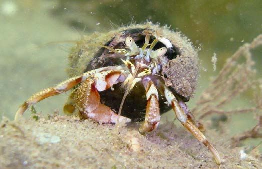
Coastal Zone Habitat
     S e a C liffs

                                                                          Ima ge by Darragh Gorman

Sea cliffs usually occur along shorelines where erosion is the dominant influence over deposition.
Coastal features such as headland are worn away by strong waves to produce steep slopes. These cliffs
can be categorised in 2 ways:

Rocky Sea Cliffs
Rocky sea cliffs typically rise over 5 meters high directly from the sea or along a narrow shoreline. To
be classified as a rocky cliff, there must be at least 50% of rock, however there may also be gravel and
loose soil found. A rocky cliff face may include features such as crevices, overhangs, and ledges.
These stable features support an abundance of wildlife, such as lichens which colonise most of the rocks.
A huge variety of coastal vegetation and seabirds also take advantage of the inaccessibility as a safe
place to breed.

Sedimentary Sea Cliffs
Sedimentary sea cliffs are over 3m high and made up of loosely compacted materials, such as mud,
sand, chalk and gravel. These materials may occur alone or as a mixture along with larger stones and
boulders. Sedimentary cliff faces appear almost vertical and are home to a variety of coastal plant life.
However, due to their unstable nature, they are easily eroded, and this may result in areas that
are totally void of vegetation.

In Ireland, sea cliffs are home to bird species such as, Fulmars, Northern Gannets, Peregrines and
Falcons and plants like Thrift, and Sea Astor.

                  Ima ge by MJ O' Ma hony                                      Ima ge by Ma rk Molly

               Fulmar on Sea Cliffs                        Gannet on Sea cliffs, Saltee Islands, Co Wexford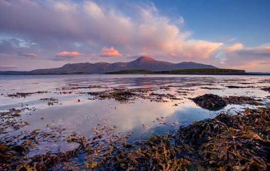
Coastal Zone Habitat
     S alt Marsh

                                                                            Ima ge by Ol ivia Jones

Salt marshes are vegetative wetland habitats found in sheltered coastal bays and estuaries. They generally
develop between the mid-neap, high spring tides levels, over waterlogged mud, sand, or peat.

The variation in tidal coverage results in two distinctive zones known as a lower salt marsh, covered twice
a day by the tide, and a n uppe r salt marsh which may only be covered a few times a month by a high tide.

This tidal variation also impacts salinity levels and exposure to the air, creating a variety of vegetative
habitats.

In Ireland, salt marshes are threatened by the grazing of livestock, trampling, car parking and invasive
species such as cordgrass and coastal development.

                Ima ge by Ol ivia Jones                                        Ima ge by Ol ivia Jones

             Salt marshes are home to many species of plants including Ragged robin and Scurvy grass
                                                                                                         Image by Mark Molly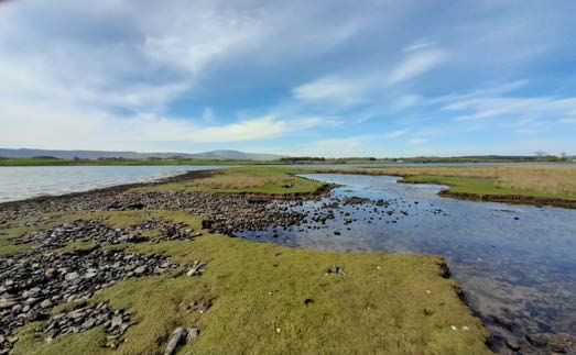
Coastal Zone Habitat
     L agoons

                                                                            Ima ge by Ol ivia Jones

Lagoons can be defined in many ways depending on what part of the world you live in. The EU’s
Habitats Directive define them as “areas of typically (but not exclusively) shallow, coastal saline water,
wholly or partially separated from the sea by sandbanks, shingle or less frequently, rocks or other hard
substrata. They retain a proportion of their water at low tide and may develop as brackish, fully saline
or hypersaline water bodies.”

Brackish water is a mix of seawater and fresh water. For a body of water to be classified as a lagoon
it must have a salinity concentration of more than 1%. This salinity content can vary greatly daily
and seasonally due to the weather and tides. Lagoons do not have a current, however, they are subject
to tidal influxes and surface water friction created by the wind.

There are roughly 90 identified coastal lagoons scattered along the coastline of Ireland. Due to
the increasing pressures lagoons face in Ireland and Europe they have been listed in Annex 1 of the
Habitats Directive as a priority habitat and have been flagged as ‘in special need of protection’.

The type of species found in lagoons depends on the saline content. The higher the salt content the
more marine species will be present, such as seaweeds.

                                                                            Ima ge by Ol ivia Jones

                                    Portavaud Saltmarsh Lagoon, Co. Sligo
INTERTIDAL ZONE - THE SEASHORE
Intertidal Zone - The Seashore
Image by Maciej Staroniewicz
The Intertidal (Littoral) Zone is the area of coastline located between the high and low tide. It is divided into 3 sections
known as:
The Upper Shore
This area of the intertidal zone is found high up on the shoreline and is only submerged during high tide. Consequently,
it can dry out on hot days and the species living here must be tough to withstand the ever-changing conditions. Com-
mon species found here include channeled wrack, barnacles and limpets.
The Middle Shore
This region of the intertidal zone is covered by the tide twice a day for equal amounts of time. You will find more spe-
cies here than the upper zone, including anemones, mussels and hermit crabs.
The Lower Shore
This area is only exposed during low tide, resulting in a more hospitable environment and a greater variety of species.
Here you will find, fish such as blennies, kelp forests, urchins and star fish.
In this zone, the tide comes in and goes out twice a day. The habitats found in this zone are classified by the material
the seashore is made up of, i.e rock or sediment. Wildlife here must show resilience and adapt to extreme changes in
temperature, light, salinity levels, weather conditions and the possibility of drying out.
Habitats found in this zone include:
Rocky shore Sand shore Shingle & Gravel Shore Mud shoreIntertidal Zone Habitat
R o cky S hores
Ima ge by Anna-Marie Fagan
The Rocky Shore gets its name from its rocky shoreland. The stability and shelter of this hard
substrate creates a safer environment for seashore communities to form. As a result, the rocky shore is
one of the most biodiverse habitats in the marine environment.
Although the rocky substrate offers shelter, the environment is also very dynamic. Due to its location in
the intertidal zone, the habitat is constantly changing from being submerged to being exposed. Exposure
can cause species to dry out in the sun, strong wave action can dislodge inhabitants from the rocks and
there are many intertidal predators on the lookout for their next meal.
In order to deal with these situations, many species have adapted to survive, including seaweeds
with anchoring holdfasts, cement fastened barnacles and the limpet with its large sucker foot that keeps
it held tightly to rocks, preventing drying out and dislodgment.
Rocky Shore Zone Species
Lyme grass, Thrift, Lichens
Splash Zone
Channeled wrack, Acorn barnacles,
Upper Shore Gut weed, Egg wrack(knotted Wrack)
Intertidal zone Middle Shore Limpets, Barnacles, Bladder wrack
Lower Shore Beadlet anemone, Dog whelk, Purple laver(Nori)
Subtidal Zone Blenny, Sea Hare, Dulse (Dilisk), Sugar Kelp
Rocky shore zones and common speciesIntertidal Zone Habitat
S and S hores
Ima ge by Ol ivia Jones
Sand shorelines are usually found in shallow bays and along the open coastline where the pull of the tide
and currents prevent silt from depositing. Sand particles can range from fine to course and may also
be exposed rock, small amounts of mud, gravel, loose pebble and shells present.
This type of habitat is fully covered at high tide and exposed at low tide. If the coastline is very exposed
lower levels of wildlife are found with sandhoppers being the most common species present. In
areas where Eelgrass grows the rate of biodiversity increases, creating habitats that act as a shelter and
nurseries for invertebrates and fish, a rich food source for birdlife.
Ima ge by Ol ivia Jones Ima ge by Ol ivia Jones
Downings beach, Co. Donegal Lugworms are a common site on our sand shores
Image by Mark MollyIntertidal Zone Habitat
S hingle and G ravel S hores
Ima ge by Ol ivia Jones
This intertidal habitat is found on shores that are fully to moderately exposed. The shoreline is made up
of course and loose gravel, pebbles and boulders. These shorelines are usually a result of a combination
of longshore drift deposition and onshore wave action. The material type and size can vary seasonally
with finer sediments often accumulating during calmer weather in the summer months.
In addition to significant amounts of materials, there is also substantial drying out in between tides. This
creates a dynamic and hostile environment where only a few species are found, typically in the form of
small crustaceans and oligochaete worms. Towards the upper strand where the environment is more
stable, you may find plant species such as sea beet, seakale and sea mayweed.
Ima ge by Ol ivia Jones
Gravel beach, Greenore, Co. Louth
Image by Mark MollyIntertidal Zone Habitat
M ud S hores/ M udflats
Ima ge by Ol ivia Jones
Mud shores are usually found in sheltered coastal areas that adjoin rivers and estuaries. These
shorelines are made up of very fine silt and clay sediment deposited by rivers. Although they are tidal,
they have reduced salinity levels due to the freshwater influx from rivers.
The habitat can appear mosaic-like at low tide with elevated mudflats crisscrossed by drainage
channels. Plant life on mud shores is low, however, it does support many invertebrate species such as
mud shrimp, cockles, mud snails and polychaetas worms. These species in turn attract wading birds such
as curlews, and oystercatchers. Many birds use these areas as a stop off to refuel on their way to
their destination.
Ima ge by Ol ivia Jones Ima ge by Ol ivia Jones
Mud Flats in Ballisodare Bay Widgeons are just some of the birdlife found on
mudflats Image by Mark MollySUBTIDAL ZONE
Subtidal Zone

                                                                                          Ima ge by Brian Torrmey

The Subtidal Zone is the area of seabed that extends seaward from the low tide mark out to the edge of the
continental shelf. It is also part of the benthic zone, which is another name for the entire ocean seabed. The
subtidal zone is always submerged underwater except for an area known as the subtidal fringe that is only
exposed during the lowest spring tides.

Subtidal habitats are primarily categorised by the seabed’s material:

Subtidal Rock habitats are made up of bedrock, accumulations of loose rock (boulders, cobbles and pebbles)
and peat substrate.

S ubtidal Sediment habitats are made of finer particles such as sand, shingle and mud.

These habitats are further categorised by the presence of algae, light levels and exposure to wave action
and tidal movement.

I n fralittoral Zone is the shallower light-filled waters where plant-life is common.

Circalittoral Zone commences as the seabed descends and light levels diminish. Plant life begins to decrease
and animal communities take over.

                 Ima ge by Mi ke Orth                                             Ima ge by Ivan Orth

         Top of the Pinnacle, Quilty, Co. Clare                S p ide r c rabs off The Saltee Islands, Co. We xford
MARINE WATER BODY
Marine Water Body
Image by Nigel Motye
A marine water body is the body of water located above the seabed. This zone begins past the low tide mark and
stretches right out to the deepest parts of the ocean, where it is also referred to as the Pelagic zone.
These vast blue spaces contain 97% of the world’s water and cover around 70% of the earth’s surface. This water is a
key component of the water cycle and when it warms up on the ocean’s surface it rises and can fall on land as rain or
snow where it further supports life there. Our ocean’s warm and cold currents also act as temperature control express-
ways and are important for the survival of many habitats and regions on earth.
The oceans also play vital role in climate regulation. They are one of the earth’s largest carbon sinks and are responsi-
ble for producing at least half of all the oxygen we breath. This process would not be possible without phytoplankton,
marine algae, plants and bacteria that take in carbon and release oxygen through a process known as photosynthesis.
Habitats found in this zone include:
Estuaries Sea Inlets & Bays Open Marine WatersMarine Water Body Habitat
E stuaries
Ima ge by Ma rc Jennings
An estuary is often described simply as ‘a partially enclosed body of water, where a river joins the sea’.
However, estuaries are really defined by their saltwater content. Only an inlet with a reduced salinity of <
30S can be classified as an estuary.
This happens when fresh river water and salty sea water are mixed by the ebb and flow of the tide, wave
action and the wind. This mix of salt and fresh water produces many complex sub-habitats including salt
marshes, swamps, and mud flats. The largest estuary in Ireland is located on the Shannon River.
Species found in estuaries include lugworms, horned wrack, curlews, grey seals, brent geese, mud
shrimp, herons and the European otter.
Ima ge by MJ O' Ma hony
Brent geese are common winter visitors to Irish estuaries
Ima ge by Anni Wilton Jones Ima ge by Ja mes Wellwood
Curlews can be found in estuaries during winter Heron are common resident in most Irish
estuariesMarine Water Body Habitat
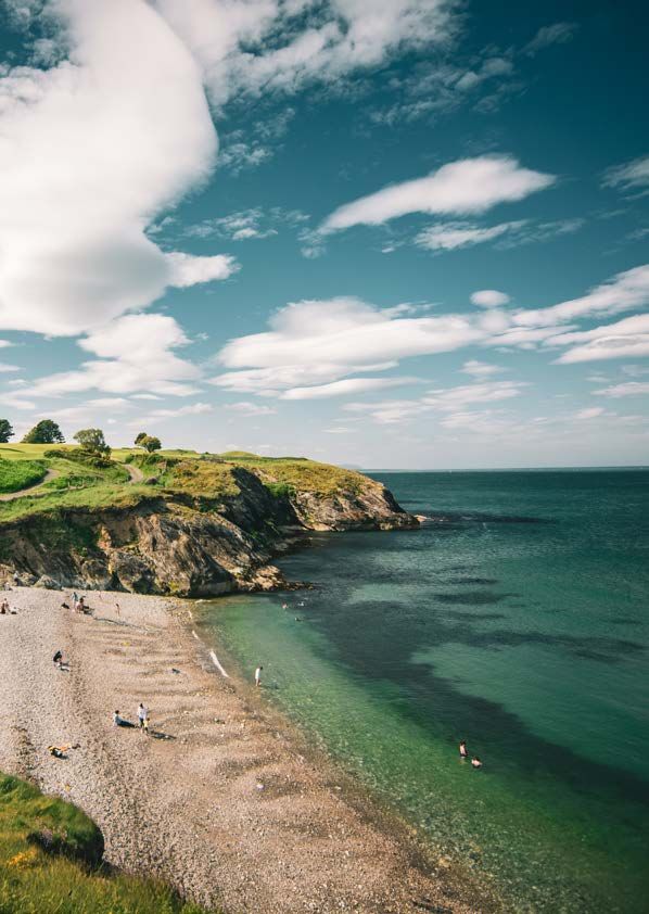
B ays and I nlets
Ima ge by Ol ivia Jones
Looking at a map of Ireland, you will see the coastline has quite an irregular shape, this is due to the
many inlets and bays found right around the coast. They range from tiny hidden coves to large bays like
Dingle and Dublin Bay. They can be found on exposed and sheltered coastlines stretching up to 2km
inland and are surrounded by at least 50% land. The water found in bays is typically salty seawater, with
little or no freshwater present. If freshwater is present from a source such as a river it can result in the
formation of an estuary in the upper region of a bay.
The seabed of bays and inlets also varies in composition depending on how exposed they are. In
sheltered bays you will find mudflats and sandflats and on more exposed coasts, courser material is
common. Bays with softer material usually support a great variety of life, with single and gravel bays
hosting less life. Many important species such as eel grass grow in bays along the Irish coastline. This is
an important keystone species, as it acts as a shelter and nursery for spawning fish and other wildlife.
Ima ge by Ja qui Ma ir Ima ge by Derek Lowry
Fanad head Dublin BayMarine Water Body Habitat
O pen Marine W ater
Ima ge by Ivan Donoghue
Open marine water habitats include coastal waters that are enclosed by less than 50% land and the
open sea. The habitat describes the body of water itself and not the seabed below, which is classified as
the benthic zone.
The characteristics of open marine water habitats vary. Shallower waters and waters near the ocean’s
surface have higher levels of light and are warmer compared to deeper regions of the ocean where light
diminishes, and pressure levels increase. These variabilities can influence the type of species you will find
from one regions of ocean to the next. Open marine water habitats are also the basis for marine food
webs with species ranging from microscopic organisms such as phytoplankton right up to the largest
mammal on earth, the elusive blue whale.
Other common animals found in the ocean are fish, squid, octopus, sharks, and marine mammals, all
these animals swim and spend much of their time in the open water.
Unfortunately, due to the amount of litter and waste entering our ocean, these habitats and species
are under threat. You can do your bit by organising a beach clean and saying no to unnecessary
packaging and single use plastic.
To find out more please visit cleancoasts.org
Ima ge by Ma rk N Thomas Ima ge by Ivan Donoghue
Horse mackerel off Tory Island Cuckoo WrasseYou can also read