Lines of Settlement: Lost Landscapes within Maps for Future Morphologies - MDPI
←
→
Page content transcription
If your browser does not render page correctly, please read the page content below
heritage

Article
Lines of Settlement: Lost Landscapes within Maps for
Future Morphologies
Paul Sanders * , Mirjana Lozanovska and Lana Van Galen

                                          School of Architecture and Built Environment, Deakin University, 1 Gheringhap Street,
                                          Geelong, VIC 3220, Australia; mirjana.lozanovska@deakin.edu.au (M.L.); lana.v@deakin.edu.au (L.V.G.)
                                          * Correspondence: paul.sanders@deakin.edu.au

                                          Abstract: The value of archival documents quite often extends beyond their original purpose, as
                                          evidence contained within these artefacts, whether written or drawn, can provide veracity for new
                                          lines of heritage inquiry. Many settlements in the ‘new world’ were set out by land surveyors
                                          whose drawings charted the accurate placement and alignment of new streets and block perimeters
                                          laid upon drawings of the extant topographical landscape features. The paper discusses three
                                          settlement maps of Melbourne, Australia, through the lens of Michel de Certeau’s idea that maps
                                          are an instrument of power are not just about recording; maps are actually about appropriating and
                                          producing regimes of place. In the Australian context, the settlement drawings, prepared under
                                          the direction of the colonial administration, inadvertently depicts Country that had been under the
                                          custodial care of the First Nations peoples for millennia, and through the intentions of the settlement
                                          maps about to be irrevocably disturbed, altered or destroyed. We raise the prospect that urban and
                                          landscape design can reflect on the ‘lost landscapes’ of cultural significance, and discuss new ways of
                                          interpreting representation through an approach of design reconciliation.


                                          Keywords: cultural heritage; mapping; surveying; indigenous place values; colonisation; Michel de
Citation: Sanders, P.; Lozanovska,
                                          Certeau; urban morphology; lost landscapes; design reparation
M.; Van Galen, L. Lines of Settlement:
Lost Landscapes within Maps for
Future Morphologies. Heritage 2021,
4, 1400–1414. https://doi.org/
                                          1. Introduction
10.3390/heritage4030077
                                                The objective of this paper is an examination of how the heritage context of colonial
Academic Editor: Éva Lovra                settlement can be re-evaluated through a contrary viewpoint to the conventional approach
                                          of urban morphology that seeks to understand urban development from its genesis, repre-
Received: 23 May 2021                     sented in archival survey maps as the starting point. Instead, we observe that these maps
Accepted: 19 July 2021                    are also evidence of an end point of a cultural landscape, an unintended artefact of this
Published: 23 July 2021                   particular heritage.
                                                Urban morphology is the study of the structure of a city’s form [1,2] from its ‘formation
Publisher’s Note: MDPI stays neutral      to subsequent transformations’ [3] (p. 3). The study of urban morphology is concerned
with regard to jurisdictional claims in   with the physical and spatial layout of urban structure and the processes that give rise
published maps and institutional affil-   to them [4]. Particular attention is given to the plots, blocks, streets, buildings and open
iations.                                  spaces which are all integral to the study of the ‘history evolutionary process’ of specific
                                          parts of a city under consideration [5] (p. 67). By recognising that ‘the past provides the key
                                          to the future . . . the spirit of a society is objectivated in the historico-geographical character
                                          of the urban landscape and becomes the genius loci’ [6] (p. 6).
Copyright: © 2021 by the authors.               There are several factors for the colonial settlement of Australia, from the earliest
Licensee MDPI, Basel, Switzerland.        British interests in the latter 1700s that led to the founding of Sydney, Hobart and Brisbane
This article is an open access article    as penal colonies and locations of defence. These were soon followed by Perth, Melbourne
distributed under the terms and           and Adelaide as new centres of free settlement, investment, speculation and trade [7]. At
conditions of the Creative Commons        the outset of each settlement, the colonial authorities relied heavily on the ingenuity of
Attribution (CC BY) license (https://
                                          the surveyors to assess the aspirations of the colonial authorities against the landscape
creativecommons.org/licenses/by/
                                          characteristics and attributes of the site under consideration to support the decision to
4.0/).

Heritage 2021, 4, 1400–1414. https://doi.org/10.3390/heritage4030077                                       https://www.mdpi.com/journal/heritage
Heritage 2021, 4 1401
establish each particular settlement. While the configuration of Sydney and Hobart aligned
to the topography and were somewhat loose in geometric pattern, the other major cities
were conceived as orthogonal street grids of varying proportions and allotment subdivision.
These schematic boundaries, once established and either sold at auction or designated for
public function, would maintain as the morphological template for future development.
Arnis Siksna undertook comparative analysis of the size of several Australian and American
city block formations, his study revealed that the relationship of ‘block size and form have
crucial and predictable effects on subsequent evolutionary patterns’ [8] (p. 24).
However, can there be other readings of survey and settlement maps of colonisation?
While these maps are in themselves heritage artefacts as historical archives, can they be
viewed as markers in a specific, dynamic, and even drastic time of change? Are these
maps instruments of the control and power that affected the change? Can we intriguingly
examine the mapped evidence from a perspective of its preceding time, as the end rather
than the starting point of built transformation, as a depiction of the ‘lost landscapes’ of
cultural significance?
2. Australian Aboriginal Country
Country is an Aboriginal Idea. It is an Idea that binds groupings of Aboriginal people
to the place of their ancestors, past, current and future. It understands that every moment
of the land, sea and sky, its particles, its prospects and its prompts, enables life [9].
Landscape is central to Aboriginal spiritual belief systems, and each area defined
by individual language groups is bound to deep understandings of how the physical
environment has been shaped, and individual and group responsibility for its custodianship
and protection [10]. Evidence suggests that humans first came to the region at least forty
thousand years ago [11]. From this time, Aboriginal people have lived in accord with the
ancient landscape and have adapted successfully to the varying weather conditions and
the enormous changes in the nature and extent of their territory. Five and a half thousand
years ago the water level in Port Phillip Bay was about two metres higher than at present.
Port Phillip Bay was a lot larger than it is now and much of what is now the inner city of
Melbourne was submerged under water. As the sea subsided to its current level, many
parts of these inner areas became boggy swamps [11].
The surface features of the Melbourne area we are most aware of today—the shape
of the bay, the vegetation and the course of the rivers, have all formed in the past five
thousand years. The surface features carry a number of traditional songlines—so named
because navigational instructions, geographic features and human-made route markers
were coded in song, sung by Aboriginal people as they travelled [11]. The tribes and
clans of the local Kulin Nation utilised these songlines to meet on occasions of plenty
in spring and late summer, and these areas served an extremely important purpose for
these meetings. Melbourne and its surrounds remain a junction for all the major songlines
heading north and west out of the city [12].
An old river red gum ‘scar’ tree, thought to be at least 300 years in age, with its deep,
elongated scar, remains a living, breathing representation of a time when the Wurundjeri
people freely exercised their way of life throughout the area. Uncle Bill Nicholson (a
Wurundjeri Elder) describes that ‘the tree was cut with a greenstone axe, quarried about
one hundred and twenty kilometres to the north of the site at a place called “Willamorin”—
“Home of the Axe”, a sacred ancestral place where axes have been quarried for tens of
thousands of years’ [12]. The large, long scar indicates that the bark taken would have
been fired into shape and used for a ‘koorong’ or canoe, a flat-based canoe which would
have been paddled out into the wetlands.
Wattle and gum trees also covered the area south of the Yarra River. Part of this forest
remained up to the 1860s but was lost as a result of the rapid growth of Melbourne, the
last remnant being the Corroboree Tree at St Kilda Junction. This tree stands just a few
kilometres from the city centre but is largely hidden from view despite the popularity of
walking trails. The corroboree tree—or ‘ngargee’ in the local Aboriginal language—holdsHeritage 2021, 4 1402
the life and memories of the things that went before it. It was the point where people joined
and moved through and celebrated the people of this land. According to Carolyn Briggs
(an elder of the Boon Wurrung people), for hundreds of years it was a meeting place for
boys who would then embark on initiation journeys. Women would also meet there before
heading to special places on the coast to learn birthing secrets [13].
These are some examples of the intricate network of landscape features that contribute
towards the manifestation of Country, where ‘everything is alive and everything is em-
bodied in relationships, whereby the past, present, and future are one, and where both
spiritual and physical worlds of Country interact’ [14] (p. 14).
3. Surveying for Settlement
Within a short space of time in the mid-1830s, British settlers had started to make
dramatic changes in the area which John Batman, one of the first pioneers who had
established a small holding on the banks of the Yarra Yarra River had called it ‘the place
for a village’ [11]. Trees were be chopped down for houses and fires. Animals and birds
were hunted for food in greater numbers than ever before. Crops were sown and sheep
and cattle grazed. Domestic cats and dogs escaped into the bush. Nothing would ever be
the same for the Aboriginal people of the Kulin Nations [11].
The attention of the colonial authorities was therefore drawn to the suitability of the
location for the establishment of a town, and procedures were initiated to affect formal
control of the area through a settlement survey and demarcation of streets and allotments
for imminent private sale [15]. However, historical accounts as to the exact attribution of the
official foundation of Melbourne has been the subject of some conjecture, with particular
reference to the two principal surveyors, Robert Russell and Robert Hoddle, whom were
consecutively engaged in the process of imposing its towns plan configuration.
Robert Russell, a ‘pioneer surveyor’, architect, and painter, had been appointed as
Assistant Surveyor in 1836 to measure and chart the Port Phillip Settlement (prior to the
naming of the Town of Melbourne). He was accompanied by two assistants Frederick
Robert D’Arcy and William Wedge Darke [15,16]. Russell was ’instructed to observe and
report upon all natural phenomena’ [16] (p. 9), and was in charge of the landscape features
survey (Figure 1) and undertook triangulation, with D’Arcy, an excellent draughtsman,
who drew the maps [15,17].
Greig suggests that despite the lack of any specific detailed instruction in the official
appointment letter from the Deputy Surveyor-General in Sydney that ordered the setting
out of a township as part of his survey, the intent of the party of three surveyors was surely
to ‘lay out a town’ to establish civil authority, in preparation for land sales [15] (p. 40).
Russell had been placed under the direct instructions of the police magistrate Captain
William Lonsdale, who understood the duties were for ‘immediate measurement of a
portion of the district, a survey for measurement of the lands’ [15] (p. 36). Furthermore, Sir
Richard Bourke (Governor General) had reported that the surveyors had been dispatched
to measure off sections and portions of the land for periodical sale [15] (p. 37).Heritage 2021, 4 1403
Figure 1. Map shewing the site of Melbourne and the position of the huts and buildings previous to the foundation of the
township by Sir Richard Bourke in 1837 [18].
The township had most likely been plotted out following the instruction of Londsdale
and under Russell’s supervision ‘on the very site occupied by the scattered huts formed the
‘un-named village’ of the original squatters’ [15] (p. 41). Russell much latter made claim
that he had made the survey of the site of Melbourne without official instruction [15] (p. 43).
The appearance of a dotted and numbered square grid on Russell’s feature map (Figure 1),
which had been sent to London to be lithographed, suggests a preliminary settlement
configuration based on his knowledge of the standard plan in the Sydney office for laying
out a new township, a copy of which he had in his possession [15] (p. 47) [17]. Critically,
the map is a record of detailed landscape features which are meticulously recorded from
which the following aspects are illustrated and written: Yarra Yarra River, Falls, Fresh Water
above the Falls, Batman Hill and Burial Hill (remains of early settlers and the site of a signal
station) [19] (p. 79), areas of Tea Tree Shrubs, Salt Lake, ‘Flat’ terrain, various tracks and
lightly wooded areas. Additionally, homesteads are drawn and labelled with the family
names of the settlers and officials [18].
The site for the town is on the banks of the Yarra Yarra River, a few kilometres upstream
from the large sheltered bay of Port Phillip. The advantages of this selected site were many.
In the 1830s and early 1840s, at the time of British arrival, the water of Birrarang (Yarra Yarra)
were home to fish of all sorts and even dolphins. The waters coursed through low, marshy
flats, densely grown with reeds and scrub, whilst on both sides of the river immense
cordons of she-oak, gums and wattles tree forests grew. Headed into the river from the bay,Heritage 2021, 4 1404
saltwater mangrove swamps once spread. Beyond this, stretching as far as the eye could
see, were rolling pastures covered with native grasses [20].
Four kilometres from the mouth, another river enters from the right. It is this river
that British settlers first called Freshwater, before being given the name Yarra Yarra, in the
mistaken belief that that was the name for the stream, in fact it was called Bay-ray-rung.
The river then curves around a once prominent hill that was to be known as Batman’s Hill.
This hill had a natural covering of she-oak and grass. About one and a half kilometres
further upstream, on the northern side were the tops of hills covered with gums [11]. East
of Batman’s Hill the river originally formed a natural basin, wide and deep, and become
known as ‘The Pond’. Immediately beyond the ‘The Pond’ was a set of rock falls consisting
of a row of basalt boulders (The Falls) which formed rapids and retarded the spread of
salt water further upstream. The Yarra Yarra River was therefore a freshwater stream
beyond this point. It was the main source of drinking water until it becomes polluted [20].
Generally, the original vegetation comprised of tall and mature eucalyptus on both sides.
In some areas there are trees that bear scars which show where bark has been removed by
the local Aboriginal people [11].
Progress of Russell’s work had been slow as he was hindered by several mitigating
factors. Despite these claims, there was doubt as to his ability and efficiency in the task,
and subsequently Bourke summoned from Sydney the Senior Surveyor Robert Hoddle to
accompany him on an official visit to the settlement in February 1837 [16,21], to directly
oversee the prompt implementation of a town layout. It is Bourke who officially confirmed
the suitability of the area selected by Batman and the other first settlers as siting for a new
town to which he named Melbourne [22] (p. 219) [23] (p. 94). ‘Hoddle was ordered to go
over afresh the ground already marked out by Russell’ [15] (p. 46), and lay out a central
grid [21] (p. 24). Bourke ‘fixed the limits of the town, and the direction of the streets’ [23]
(p. 89), to which he also affixed European names [17] (p. 56). Only the Yarra Yarra River
retained an Indigenous Australian reference on the official first map of Melbourne. It is
noted that Hoddle, overseeing the management of Melbourne’s immediate expansion,
named many early suburbs with local Indigenous Australian names, for example: Prahran,
Tukulreen, Jika Jika and Borondarra [23].
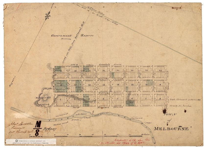
Therefore, as Melbourne’s first Surveyor general, Robert Hoddle confirmed the set-
tlement grid with the alignment of streets and subdivision of allotments within the street
blocks. The Melbourne layout is indeed unique mainly for ‘the “little” streets that were
placed between the city’s cross avenues to allow ease of rear access’ [7] (p. 18). Hoddle
authored a map ‘Town of Melbourne’ (dated 25 March 1837) for the intention of the first
land sales [17], which shows the positioning of the grids aligning with the reach of the
Yarra Yarra River and extremity of Salt Water terminating in the natural falls, and offset
from the protrusion of Batman’s Hill, from which there is a settling out line (Figure 2).
The river and hill are the only landscape features recorded on this map. The grid was
apparently ‘superimposed onto the land with no consideration for the natural features of
the site’ [7] (p. 11).Heritage 2021, 4 1405
Figure 2. Town of Melbourne [cartographic material]/Robert Hoddle, Surveyor, Port Phillip, 25 March 1837 [24]. According
to Selby [17] the map was drawn prior to receiving material from Russell; hence, it is void of the full landscape features
except for the inclusion of Batman’s Hill and ridgelines, Yarra Yarra River (indicating the position of the falls), scattered
settlers homesteads, and a few notations of vegetation.
Hoddle subsequently gained popular recognition and attribution for making the first
plan of Melbourne [17] with oversight to Russell’s earlier work perhaps as a consequence
for his perceived unsatisfactory progress [15]. The pervasive narrative being that Russell
had made a topographical features survey of the ‘ultimate site of Melbourne upon which
Hoddle subsequently drew the familiar grid plan’ [16] (p. 9), and whom designed the
layout of streets and allotments for the new town [17]. Hoddle’s letter (10 April 1837)
states ‘from Mr Russell I could only obtain a plan of the settlement executed by himself
and Mr D’Arcy on which I drew a plan of the town of Melbourne’ [17] (p. 57). Figure 3 is
the superimposition, Hoddle’s arrangement of named streets and numbered allotments
overlaid onto Russell’s landscape features survey.Heritage 2021, 4 1406
Figure 3. Town of Melbourne and Plan of the Settlement—Port Phillip. 1837. Part section. Public Records of Victoria—
Historic Plans Collection [25].
Despite this debate, our interest is in a reading of the two maps as being: Figure 1,
Russell’s map of extensive detail of landscape features, onto which the township is lightly
indicated, and, Figure 2, Hoddle’s map which conversely sets out a settlement geometry
in bold lines, with only Batman’s Hill and the Yarra Yarra River with Falls as topographic
features to aid the positioning of the grid. ‘The old falls on the Yarra really determined the
position of the city’ [15] (p. 47). Yet, these were to be the prominent landscape features
that would be expendable in the execution of infrastructural development of the fledgling
town. A further collective understanding of the three maps is that they can all be viewed
as instruments of power in the process of colonisation and dispossession, a theme which
will be explored further in the next section.
4. Unwitting Evidence within Maps as Instruments of Power
Michel de Certeau’s idea that maps are an instrument of power represents a very
important set of thoughts and way of thinking about maps that has subsequently been
taken up by architectural thinkers [26,27]. In his seminal work The Practice of Everyday Life,
de Certeau talks about maps as instruments of power because maps centre power in place
and implement a geometric schema for understanding space [28] (p. 124). Relating this
understanding to the context of maps during colonization makes evident that the survey
of the land was a way of appropriating the land. Speculation inherent in the map or plan
was perceived as a constructed future superimposed onto the existing land, altering both
its physical and socio-cultural topography [27]. The map materialises that speculation,
and makes it more real than perhaps the intention because the map draws the vision in
a pragmatic sense. The map thus pre-empts the change, alteration and transformationHeritage 2021, 4 1407
in relation to an existing reality. The map operates in a dual sense as projection of a yet
unrealized future and as a representation of existing realities, and the cartographic or visual
tools and methods tend to delineate what is drawn and what is not represented [29]. As a
method of a projected future on the surveyed environment the map surpasses the moment
of that reality and shapes forthcoming realities. Maps and cartography, like land surveys,
are not neutral.
The end result is a record of a spatial environment upon which is a manifestation of
time: time and the historical moment are frozen within the paradigm of a map, disclosing
a spatial environment distinct from the flow of time and a sense of the unknown of what
was to come. Colonial appropriation thus occurs across both space and time as axis but
also as intersecting forces. For example, a map may represent a grid (even though this
is something that does not yet exist in the early 1800s in Melbourne) but not necessarily
the pathways or sites of inhabitation of the Indigenous peoples. From this perspective we
can see that maps were integral to the larger scope of colonization as an appropriation
of territory and as selective representation of realities [27]. Maps delineated the spatial
order about the future of society. These were visions that projected onto particular sites
and both imagined and articulated a transformation of that site into place. The maps of
Russell and Hoddle actually determined a particular future for the site as a place for the
city of Melbourne.
De Certeau discusses maps as instruments of power that produce regimes of place.
Investment through the process of mapping and cartography constructs the place in
question into a node or centre, and this action is not neutral but a determined strategy of
colonial power. De Certeau connects spatial strategy, with maps and with place such that
these three elements go together, and are organized in such ways as centres of authority
and the law [28] (pp. 34–44). In that sense politics does not exist outside of maps, and
colonization cannot exist without mapping. The map is a critical instrument and a tool
deployed to deliver the strategies and processes. Important to de Certeau’s theory is the
contrasting of place and space. While the regimes of place are produced by maps and
strategy, and they become strategic places of authority and power, so place is linked to
authority power, law and strategy.
Space, in de Certeau’s theory, is a loosened activity. Space is not unmapped, but it is not
strategic to the map, and difficult to map, and historically it is much less mapped in official
documents [28] (pp. 115–120). For example, one can imagine a picture (drawings, paintings)
and this is also shown in early colonial photographs, of the co-existence of the Indigenous
people within the ‘places’ established in the early times of colonization [30]. They co-
existed within the places in a way that de Certeau calls tactic, whereby, the Indigenous
people navigated the then newly imposed spatial order of the place and the strategic order
of laws, boundaries and structures (Figure 4). Indigenous ‘tactical’ coexistence within
these regimes of place was not represented on the official maps, or was officially omitted
from the mapping of the place. Tactic is linked to what de Certeau defines as space,
spatial co-existences that are interwoven within place. From this perspective a tactic can
be considered ‘out of place,’ and that is exactly de Certeau’s point, that these are spatial
navigations within the regime of place which use that place differently to its intention.Heritage 2021, 4 1408
Figure 4. Melbourne from the falls, 30 June 1837 [31]. In this image, the ‘first picture of the settlement’ [16] (p. 8), Russell
depicts local Indigenous Australian inhabitants crossing the falls on the Yarra Yarra River, a significant landscape feature as
a natural bridge. Across the river are early settler huts and tents, in the distance are the native woodlands.
The intention of the colonisers’ settlement did not account for the co-existence, and in
addition, the customs and activities of the Indigenous people. On the one hand, maps are
instruments of power used to produce places that are strategic for the political intention
and agenda, and in this case settler colonization. On the other hand, activities that do
not fit into the scope or colonial vision of maps, and a regime of place as strategy, are
those tactics and spaces that are temporal ‘actions of the weak’ [28] (pp. xvii and 119).
Importantly, such tactics, de Certeau argues, can redefine place temporarily as a very
different space [28] (p. 37). This presents a potential of the spatial realm that is outside the
gaze and power of the regime of place. Within the first few years of settlement, Aboriginal
peoples were almost entirely displaced from the Melbourne area [22]. Nonetheless many
Indigenous communities and individuals also co-existed within the same spatial environ-
ments, navigating the implanted order, authority and strategy of the newly constructed
place. Therefore, ‘continuing aspects of Aboriginal cultures with expressions in values of
place have persisted . . . and evolved through many transformations and adaptions until
the present day’ [32] (p. 1).
Russell’s maps and painting represent the concerted efforts of a landscape surveyor to
record the extant condition around the site of colonial settlement. They are also artefacts of
historical time—capturing the ‘lie of the land’ as it was perceived and recorded by Russell
in 1837. In this sense, and for architectural historians/archaeologists, such documents can
serve as evidence for other readings of history making. Figure 4 depicts the Indigenous
people crossing the Yarra Yarra River at the point of the falls, continuing a time- honoured
act of daily life within the fledgling surroundings of occupation. Within a short space
of time, such landscape features will be irrevocably decimated in service of the rapidHeritage 2021, 4 1409
construction of colony. This painting is therefore a record of a ‘tactic’ in de Certeau’s sense
of the division between strategy and tactic. It captures firstly the extant co-existence of
Indigenous communities within the scope of colonizing instruments of documentation and
representation. Secondly, it illustrates a site that has been identified as significant for the
Indigenous communities of the Bun Wurrung and Woi Wurrung peoples of the area [11].
A third aspect is that it indicates that indigenous presence, both—the act of indigenous
people crossing and the site of the falls—co-exists as tactical non-strategic space within the
regime of place that materialised as the new grid of Melbourne.
Therefore, it is possible to compare the two maps allocated as Russell’s map against
Hoddle’s map (Figures 1 and 2) by identifying the prominent landscape features as a
significant part of Russell’s map that are suppressed within Hoddle’s, to the extent that
only the river and hill were recorded as a reference point for the positioning of the grid.
Russell’s map is an active intention and illustrates a comprehensive, observational and
detailed approach in its record of the existing terrain and vegetation as necessary for its
role in surveying the terrain for colonisation. Yet, it is an inadvertent record of Aboriginal
Country, an unwitting record of features of local places that (we now know) are significant
to Indigenous history and therefore critically evidence that it was un-ceded colonization,
and that the establishment of colony was not terra nullius, as was claimed by the colonisers.
Hoddle’s map is the intent and blueprint for radical change. Between the two maps is a
decision to omit these landscape sites in the transfer from an observational map of the land
(Russell’s map) to the next level of the map as strategy. It is one in a series of procedures
that determine the power and authority of the colony. Such map redrafting—and the
imprecision of the transfer—illustrates how the determinants of the making of the colony
are at work in this otherwise perceived empirical exercise. Maps are subjected to the
cartographer’s gaze, and what the cartographer wants to see, in addition to the strategic
and political objective. Hoddle’s map presents the erasure of sites of the land that belonged
to the inhabitants of the land, drafting a contract of ‘wishful’ but colonial determined terra
nullius. These maps were both created as instrument of power, but they can now be used
against their intention as historical artefacts, that open up a different lens on the history
of this place. We can now appraise the recorded lost landscape features, for example the
Yarra Yarra Falls and Batman’s Hill, evident in the archival settlement maps, and renew an
understanding of their original significance.
5. The Destruction of Cultural Heritage Places of Significance
Several known important sites of significance within the bounds of Melbourne’s
initial settlement were to be destroyed in the face of the expanding town. There was
little or no appreciation for cultural places, or the thought of preserving their inherent
landscape features. We highlight and discuss the two important landscape features that
were prominent in Hoddle’s survey (Figure 2), ‘that map of the allotments, with only
Batman’s Hill and the Yarra marked on it, is our first map’ [17] (p. 56).
5.1. Yarra Yarra Falls
In 1835, when Europeans settled at the site of what was to become Melbourne, there was a set
of rock falls across the Yarra River. These falls prevented salty, tidal water mixing with fresh river
water. Melbourne was chosen for settlement largely because fresh water could be obtained from the
Yarra above the falls [19] (p. 6).
The rocks presented a natural crossing for Aboriginal people of the area (see Figure 4),
and was a location of great importance, not only for its physical attribute as a natural bridge,
but it provided a place for local clans to meet for ‘law, social, and ceremonial purposes’ [33]
(p. 11). Immediately below the falls the salt water had opened up a wide and deep basin,
suitable for anchorage of settler ships (see Figures 1, 2 and 5). The rocky crossing was latter
dammed to improve the fresh water supply, but contributed to major flooding problem
and was subsequently blown up in 1860 to allow ships to navigate further up the river [33].
The location of the former falls is now the site of Queens Bridge.Heritage 2021, 4 1410
Figure 5. The City of Melbourne, Australia in 1885 [34]. Part detail. Batman’s Hill is prominent to the edge of the city grid.
Additionally, note that the falls are evident to the immediate left of the railway bridge, preventing the sailing ships from
further passage upstream.
5.2. Batman’s Hill
The hill adopted the name from John Batman who had arrived in 1835 as one of the
first pioneers [15] (Greig, 1919) to set up a ‘headquarters for exploiting the surrounding
land’ [7] (p. 11), and established a homestead and farm on the slopes of the hill. Batman had
claimed to have purchased the land from local Aboriginal people; however, the colonial
authorities considered the first settlers as illegal occupiers of Crown Land. Consequent to
the surveying and planning of Melbourne discussed earlier, Batman’s Hill was appropriated
for various civic functions, the house as a superintendent’s office, and as a grandstand
for horse races [7]. In 1847 a powder magazine was constructed on its western slope and
navigation beacons were erected to take advantage of the hill’s prominence [35].
A contract to excavate and remove Batman’s Hill was signed in November 1863 to
make way for a new railway station, and so the entire landscape feature, along with the
early settlement buildings were completely levelled. Figure 6 is a somewhat dramatic scene,
depicting the manual labour of the removal of the hill, possibly drawn as a record of colonial
advancement, but can now be viewed as evidence of a cultural landscape desecration.Heritage 2021, 4 1411
Figure 6. Removing the last of Batman’s Hill. Extract from Batman’s Hill—past and present [36].
6. Reparation through Design
We are becoming increasingly aware of the difficulty and continuing legacy of Aus-
tralia’s history as a settler society . . . [that] occurred with minimal understanding of our
environmental context and no knowledge of its prior occupation [37] (p. 29).
Australia, as is the case with other colonised countries, is still in the process of coming
to terms and re-examining the veracity of conventional accounts of its history, heritage and
culture. Until relatively recently knowledge of a ‘pre-European history and ecology has
been lacking’ [37] (p. 30). Acts of reconciliation have included various political statements
of recognition of past injustices and atrocities, in the form of formal apologies of the
national government to the Indigenous Australians. However, the design professions
and educational institutions have been slow to embrace momentum to affect significant
change in current practice. New paradigms have nonetheless been provoked by several of
Australia’s Indigenous architects.
Kevin O’Brien has developed a radical proposition called Finding Country that emerged
from his Masters of Philosophy thesis at the University of Queensland. A series of design
studios have subsequently been undertaken where project participants are asked to execute
the hypothetical removal of 50% of a selected urban grid. What follows is a contemplation
of not what has been removed, but what can now be seen, an engagement with ‘a palimpsest
to erase a certain part of the text of the city to reveal a presence that had been covered
over and ignored’ [38]. A negotiation is thus required with the lost landscapes of Country
before a new architectural insertion can be made. A tapestry map from a Finding Country
studio project was exhibited as a collateral event at the 2012 Venice Biennale, at which
O’Brien ceremonially burnt the drawing ‘in an act of symbolic renewal and as a statement
of positive intent’ [38] in homage to the customary burning of landscape by Aboriginal
people for renewed growth.
The Aboriginal map of Australia reveals a continent with many Countries and many
spaces. The prevailing spectrum of architectural positions, bookended by decorated sheds
and metaphysical decks, continues to bring Aboriginal Country into decline. If theHeritage 2021, 4 1412
opposite position is considered it is possible to find something lost. Cities historically
enter states of decline, frequently associated with some form of catastrophe. Others end in
a whimper. It is not unreasonable to imagine an opportunity for the recovery of Country
through decline [9].
Jefa Greenaway and colleagues Janet McGaw and Jillian Walliss have instigated
a creative research student project at the University of Melbourne that engages with
Indigenous place-making through three research methods of: Deep Listening, Mapping
Place and Time and Critical Spatial Practices [37]. The project re-examined Russell’s
1937 map (Figure 1), and identified the several important places of cultural significance,
including The Falls and Batman’s Hill. The outcome of the project was a number of creative
works that included a spatial performance called The Falls involving participants recreating
a waterfall by pouring bottled water from a bridge at the location, a temporal recreation
of the lost landscape feature. This work thus appropriates the maps as ‘informational
tools’ of significant landscape sites which it then re-performs towards a communicative
and community act, as a corporeal and signifying revision of historical erasure. Such use
of maps may join methods of oral histories, and further archival historical documents, to
build a very different map of the embedded memories of the sites the place of Melbourne.
O’Brien and Greenaway have been active in both private architectural practice while
also formally appointed within leading Australian universities to advance critical thinking,
research and teaching on the advancement of Indigenous agendas in architecture. Uni-
versities play a crucial role in accelerating awareness and change in society, in the context
of applied research into Indigenous environments. Paul Memmott as an anthropologist
and architect, for many decades has been instrumental in leading as Director The Abo-
riginal Environments Research Centre (AERC) at the University of Queensland [39]. The
centre has been responsible for extensive research projects and publication outputs. David
Jones and colleagues [14] have collated and published a comprehensive guide for tertiary
educators that sets out a carefully researched and informed overview that includes: an
understanding of Country, protocols for respectful engagement with Indigenous issues,
and introduction to Indigenous cultural heritage whereby ‘all tangible and intangible
aspects of a landscape may be important . . . as comprising their ‘living heritage’ whereby
the ‘spiritual relationship [with landscape] is an important aspect of Indigenous cultural
heritage’ [14] (p. 23).
7. Discussion
There can be multiple readings of the same document, but these readings may be
counter to each other and framed by a very different historiography. Survey maps were
deployed as instruments of power establishing strategic places in the formation of cities
such as Melbourne. The British olonial authority was made manifest in the projection of
the strategic place as the grid within the colonial settlement map. Importantly, the strategic
place is intrinsic to the map as a vision even prior to the actual laying out of the city. As
a drawing artefact, it also generates a colonial imaginary, a visual paradigm about that
site. One risk of visual documents is their reading as evidence, rather than as artefacts to
be subjected to analysis and interpretation, as this subsequently generates a retrospective
historical order that appropriate the colonial agenda as a neo-colonial historiography.
Further, visual documents including artistic paintings and drawings participate in the
processes of establishing place as a strategic centre. Such works need to also be subjected
to analytical enquiry in order to avoid the replication of colonial bias.
A further reading, is how topographic features maps unwittingly provide evidence of
the original cultural landscape that had the inescapable fate of destruction by virtue of the
morphological intent of the surveyor’s settlement configurations. Their lines of settlement
became lines of dispossession. The maps also can be read as tracing the existence and
livelihoods of Indigenous peoples alongside the strategic agenda for colonisation. The
maps featured in this paper illustrate sites that were, and are significant to the Indigenous
communities of the Bun Wurrung and Woi Wurrung peoples in the vicinity of Melbourne.Heritage 2021, 4 1413
In the 1800s these communities navigated within this new order, new authority, and new
law, by tactically using the interstitial spaces in this map, or by using them in an interstitial
way. De Certeau calls tactics those very activities which are temporal uses of places, and
this sense of how places may be extracted from their deployment as strategic creates the
spatial sense of place. This possibility and openness is defined by the term space, and in de
Certeau’s sense is in contradistinction to place [28].
8. Conclusions
We have established that in the process of surveying for colonial settlement, the maps
that were created in preparation for the establishment of new towns inadvertently depict
Indigenous cultural landscapes that were under imminent threat. The scrutiny of such
historical drawings from the viewpoint of looking back in time to the origins of the urban
transformation process is the basis of urban morphology research. However, a reversal
occurs when considering the topographical landscape surveys as a representation of a
terminal moment of the physical features and forms of that location. This paper identified
the cultural heritage significance of landscape features that were embedded within these
drawings, represented in a moment in time before being erased. Therefore, these maps were
instruments of power in the dispossession of land from the Indigenous Australian people.
Nevertheless, a reparation process in architecture, urban design and landscape architecture
is underway in Australia through creative strategies of design and performative events,
that provide a glimpse of lost Country.
Author Contributions: Conceptualization, P.S. and M.L.; methodology, P.S. and M.L.; writing—
original draft preparation, P.S., M.L. and L.V.G.; writing—review and editing, P.S. and M.L. All
authors have read and agreed to the published version of the manuscript.
Funding: This research received no external funding.
Institutional Review Board Statement: Not applicable.
Informed Consent Statement: Not applicable.
Conflicts of Interest: The authors declare no conflict of interest.
References
1. Kropf, K. The Handling Characteristics of Urban Form. Urban Des. 2005, 93, 18–19.
2. Whitehand, J.W.R. Conzenian urban morphology and urban landscapes. In Proceedings of the 6th International Space Syntax
Symposium, Istanbul, Turkey, 12–15 June 2007; pp. ii01–ii09.
3. Moudon, A.V. Urban morphology as an emerging interdisciplinary field. Urban Morphol. 1997, 1, 3–10.
4. Carmona, M.; Tiesdell, S. (Eds.) The Morphological Dimension. In Urban Design Reader; Elsevier/Architectural Press: Oxford, UK,
2007; pp. 59–62.
5. Bentley, I.; Butina, G.; Gleave, S. Urban Design. Archit. J. 1990, 192, 61–71.
6. Whitehand, J.W.R.; Larkham, P.J. (Eds.) The Urban Landscape: Issues and Perspectives. In Urban Landscapes: International
Perspectives; Routledge: London, UK; New York, NY, USA, 1992; pp. 1–19.
7. Statham, P. (Ed.) Patterns and Perspectives. In The Origins of Australia’s Capital Cities; Cambridge University Press: Cambridge,
UK, 1989.
8. Siksna, A. The effects of block size and form in North American and Australian city centres. Urban Morphol. 1997, 1, 19–33.
9. O’Brien, K. Finding Country. 2012. Available online: http://www.findingcountry.com.au/#/information/about (accessed on
7 July 2021).
10. Dudgeon, P.; Wright, M.; Paradies, Y.; Garvey, D.; Walker, I. The social, cultural and historical context of Aboriginal and Torres
Strait Islander Australians. In Working Together: Aboriginal and Torres Strait Islander Mental Health and Wellbeing Principles and
Practice; Purdie, N., Dudgeon, P., Walker, R., Eds.; Australian Institute of Health and Welfare: Canberra, ACT, Australia, 2010;
pp. 25–42.
11. Presland, G. The Land of the Kulin, Discovering the Lost Landscape and the First People of Port Phillip; McPhee Gribble/Penguin:
Fitzroy, Victoria, 1985.
12. De Bolfo, T. Long before the Blues, Where the Beyal Lies. Carlton Media. 2019. Available online: https://www.carltonfc.com.au/
news/236241/long-before-the-blues-where-the-beyal-lies (accessed on 16 May 2021).Heritage 2021, 4 1414
13. Percy, K. Victorian Aboriginal Leaders Promote Better Local Understanding of Culture, History. ABC News. 2014. Available
online: https://www.abc.net.au/news/2014-12-14/aboriginal-leaders-promote-better-understanding-local-culture/5964934
(accessed on 16 May 2021).
14. Jones, D.S.; Low Choy, D.; Tucker, R.; Heyes, S.A.; Revell, G.; Bird, S. Indigenous Knowledge in the Built Environment: A Guide for
Tertiary Educators; Australian Government Department of Education and Training: Canberra, ACT, Australia, 2018.
15. Greig, A.W. The Official Foundation of Melbourne. Vic. Hist. Mag. 1919, 12, 35–48.
16. Preston, H. Robert Russell, the Father of Melbourne. R. Vic. Inst. Archit. Bull. 1956, 8–15.
17. Selby, I. Robert Hoddle and the Planning of Melbourne. Vic. Hist. Mag. 1928, 13, 52–64.
18. Russell, R.; Bourke, R. Day and Haghe. In Map Shewing the Site of Melbourne and the Position of the Huts and Buildings Previous
to the Foundation of the Township by Sir Richard Bourke in 1837; Day & Haghe: London, UK, 1837. Available online: http:
//nla.gov.au/nla.obj-231448674 (accessed on 7 July 2021).
19. Eidelson, M. The Melbourne Dreaming: A Guide to the Aboriginal Places of Melbourne; Aboriginal Studies Press: Canberra, ACT,
Australia, 1997.
20. Flannery, T. The Birth of Melbourne; The Text Publishing Company: Melbourne, VIC, Australia, 2002.
21. Hoddle Colville, B. Robert Hoddle: Pioneer Surveyor, 1794–1881. Globe 2005, 57, 17–26.
22. Priestley, S. Melbourne: A Kangaroo Advance. In The Origins of Australia’s Capital Cities; Statham, P., Ed.; Cambridge University
Press: Cambridge, UK, 1989.
23. McComb, H.S. Surveyor Hoddle’s Field Books of Melbourne. Vic. Hist. Mag. 1937, 16, 77–101.
24. Hoddle, R. Town of Melbourne 1937 [Cartographic Material], 1837. Historic Plan Collection, Public Record Office Victoria, VPRS
8168/P2, Unit 6166. Available online: https://beta.prov.vic.gov.au/collection/PID2174256843 (accessed on 7 July 2021).
25. Hoddle, R. Town of Melbourne and Plan of the Settlement—Port Phillip. 1837. Historic Plan Collection, Public Record Office
Victoria, VPRS 8168/P2, Unit 6188. Available online: https://beta.prov.vic.gov.au/collection/PID3174257067 (accessed on
7 July 2021).
26. Wigglesworth, S.; Till, J. (Eds.) The Everyday and Architecture; Special Issue Architectural Design; Academy Press: Cambridge, MA,
USA, 1998.
27. Ross, E.; Bigon, L. The urban grid and entangled planning cultures in Senegal. Plan. Perspect. 2018, 34, 779–804. [CrossRef]
28. De Certeau, M. The Practice of Everyday Life, Trans. Steven Rendall; University of California Press: Los Angeles, CA, USA, 1984.
29. Cattoor, B.; Perkins, C. Re-cartographies of Landscape: New Narratives in Architectural Atlases. Cartogr. J. 2014,
51, 166–178. [CrossRef]
30. Ferdinand, S. Mapping beyond Measure: Art, Cartography, and the Space of Global Modernity; University of Nebraska Press: Lincoln,
PA, USA, 2019.
31. Russell, R. Melbourne from the Falls. 30 June 1837. Available online: http://nla.gov.au/nla.obj-134644646 (accessed on
17 May 2021).
32. Greenop, K.; Memmott, P. Urban Aboriginal Place Values in Australian Metropolitan Cities: The Case Study of Brisbane. In Past
Matters: Heritage and Planning History—Case Study from the Pacific Rim; Miller, C., Roche, M., Eds.; Cambridge Scholars Press:
Cambridge, UK, 2007; pp. 213–245.
33. Eidelson, M. Melbourne Dreaming: A Guide to Important Places of the Past and the Present, 2nd ed.; Aboriginal Studies Press: Canberra,
ACT, Australia, 2014.
34. Whittock, N.; Teale, G. The City of Melbourne, Australia [Picture]/Drawn by N. Whittock from Official Surveys and from
Sketches Taken in 1854 by G. Teale Esqr. of Melbourne. 1855. Lloyd Brothers and Co: London. Available online: https:
//catalogue.nla.gov.au/Record/1474920. (accessed on 8 July 2021).
35. Points of Interest Australia. Batman’s Hill c 1835—Cnr Spencer and Flinders Sts, Docklands, Melbourne, VIC. Available
online: https://poi-australia.com.au/points-of-interest/australia/victoria/docklands/batmans-hill-cnr-spencer-flinders-sts-
melbourne-vic/# (accessed on 16 May 2021).
36. MacFarlane, J. Batman’s Hill—Past and Present. 1892. David Syme and Co: Melbourne. Available online: http://search.slv.vic.
gov.au/primo-explore/fulldisplay?vid=MAIN&docid=SLV_VOYAGER1773468&context=L (accessed on 8 July 2021).
37. Greenaway, J.; Mcgaw, J.; Walliss, J. Designing Australia—Critical Engagement with Indigenous Place Making. In Design for a
Complex World, 1st ed.; Cairns, G., Ed.; Libri Publishing: Oxfordshire, UK, 2014; pp. 29–54.
38. Grace, R. Finding Country, Architecture Australia. 2013. Available online: https://architectureau.com/articles/finding-Country/
(accessed on 7 July 2021).
39. Paul Memmott—UQ Researchers. Available online: http://researchers.uq.edu.au/researcher/39 (accessed on 16 July 2021).You can also read