Le Pas des Ondes Cornillon-sur-l'Oule
←
→
Page content transcription
If your browser does not render page correctly, please read the page content below
PNR Baronnies provençales

Le Pas des Ondes
Cornillon-sur-l'Oule

Lac du Pas des Ondes (Pnr Baronnies provençales)

A family stroll along the water of the                                         Useful information
Pas des Ondes, true "oasis” of the                                             Practice : WALKING
Baronnies Provençales.
                                                                               Duration : 45 min
This flat path road oscillates between the Pas des Ondes
lakes and the bank of the Oule river. This easy walk and                       Length : 2.2 km
walkable with a stroller (if you do not go to the Clue) invites                Trek ascent : 51 m
the stroll and the observation of nature related to these
aquatic environments.                                                          Difficulty : Very easy

                                                                               Type : Boucle

                                                                               Themes : Fauna, Waters and rivers

                                                                               Accessibility : Disabled person, Stroller

                                               06/28/2022 • Le Pas des Ondes                                          1/9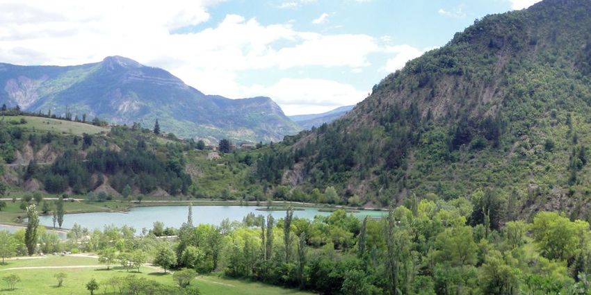
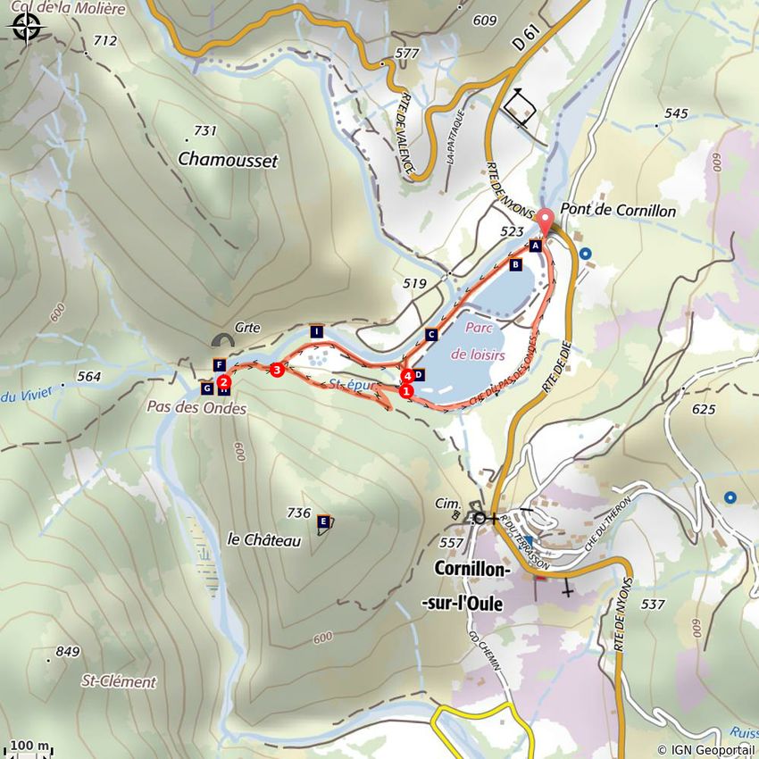
Trek

Departure : Body of water of the Pas des Ondes, Cornillon-sur-l'Oule
Arrival : Cornillon-sur-l'Oule

By being parked in the Pas des Ondes car park (parking and access to the water body in July and August
are not free), return to the entrance gate of the site. Take the bank path between the Oule river and the
lake : The starting point of the theme trail "Faune aquatique du Pas des Ondes" is located there. Follow
this flat path for 600 meters to the end of the second lake and pass to the left of the educational pond.

1- Shortly after the two fishing pontoons, facing the hill surmounted by the ruins of the castle, take the
small path that goes up the slope. After a turn on the left, the path leads to another path: take a right on
this new path crossing towards the river, down to a road. Take a left on the path which turns into a path
and join the bank of the river to a pebble beach.

2- Turn back and join the previous intersection.

3- Follow straight on the flat path between the river and the treatment plant and return to the
educational pond.

4- Continue the tour of the water bodies along the banks by the flat road or the path through the grass
that can be seen near the shores of water bodies.

                                          06/28/2022 • Le Pas des Ondes                                  2/9
On your path...
The Pas des Ondes: the landscaped oasis! Hydraulic operation of the basins (B)
(A)
The Pas des Ondes birds (C) Fish and recreational fishing (D)
The Cornillon old castle (E) The tufo waterfall (F)
La Cluse: True Pas des ondes! (G) The inhabitants of the Oule cliffs (H)
The beaver, this amazing builder! (I)
06/28/2022 • Le Pas des Ondes 3/9All useful information
Advices
Parking and access to water body are not free in July and August.
Altimetric profile
Min elevation 514 m
Max elevation 541 m
Access Advised parking
4 km south of La-Motte-Chalancon, by the D61. Parking du Pas des Ondes
06/28/2022 • Le Pas des Ondes 4/9On your path...
The Pas des Ondes: the landscaped oasis! (A)
Due to their good integration into the natural site of Pas des Ondes, these two
water bodies do not necessarily show that they are actually artificial.
Developed in the 90s to support local tourism development, the site of Pas des
Ondes has since been an oasis particularly popular in the summer season. The
smallest of the water bodies is intended for swimming while the largest is
reserved for fishing.
Attribution : Pnr Baronnies provençales
Hydraulic operation of the basins (B)
The hydraulic system of the bathing water of the Pas des Ondes reconstitutes a
natural scheme of operation thanks to its settling basin where circulates the
water that comes from the Oule with a flow rate of 30 L / s. The purpose of this
pond is to filter and capture the fine particles of silt in suspension to limit the
turbidity of the water and to keep a maximum of clarity for swimming. Once
past the swimming lake, the water flows into the fishing pond before returning
to the Oule.
Attribution : Millot.L.
The Pas des Ondes birds (C)
Between the banks of the river and those of the lakes, the gray heron and the
Martin fisherman each have their hunting stations while the Black Milan
occupies the role of the cleaner by recovering the corpses of fish and
amphibians. The water bodies also host several species of remarkable birds for
the region, in staging areas such as the Knights Cul-blanc and Guignette, the
Northern Shoveler or Garganey and exceptionally the Osprey.
Attribution : Millot.L
Fish and recreational fishing (D)
The fish fauna of the lake was introduced during the creation of lakes in the
90s. Among these non-endemic fish in the environment are carp, roach, tench
and rainbow trout, introduced to promote recreational fishing. The most
representative species is the carp but we also find the Chevesne and the
Common Perch (only predator). Two fishing pontoons are set up on site,
including one for people with reduced mobility.
Attribution : Pnr Baronnies provençales
06/28/2022 • Le Pas des Ondes 5/9The Cornillon old castle (E)
The Cornillon-sur-l'Oule castle is one of the most impressive testimonies of the
Provencal comtal power which controlled, between the 13th and the 15th
century, a set of seigniories in the Oule valley, called the "claverie de l'Oule".
The dimensions of the sides of its triangular enclosure are 44, 30 and 51
meters. To the east and below the castle stood the medieval village of Cornillon
which only a portion of the northern wall that meets the castle is still visible.
Attribution : Pnr Baronnies provençales
The tufo waterfall (F)
On the right bank of the Oule, at the beginning of Pas des Ondes parade, a tufo
waterfall flows into the river. The tufo that forms the yellow structure of the
waterfall is a type of rock that is formed by the limestone and CO2 contained in
the water that gushes at this location. The limestone "precipitates" by
enveloping the algae and mosses that grow on the waterfall. The plant
engulfed by limestone dies little by little and contributes to create a limestone
structure perched with small holes: the tufo.
Attribution : Pnr Baronnies provençales
La Cluse: True Pas des ondes! (G)
The lakes of "Pas des Ondes" take their name from the nearby natural site
downstream. The true Pas des Ondes is indeed the clue of the parade of Oule
between the two cliffs falling from the mountain of Chamousset on the one
hand and that of the Castle on the other hand. The river has dug its way to this
place, forming small gorges whose calm, freshness and rustling water contrast
with the landscaped site.
Attribution : Pnr Baronnies provençales
The inhabitants of the Oule cliffs (H)
The Pas des Ondes cluse is a remarkable habitat for many European birds of
interest that nest in its high rocky boulders. The sector is classified in Natura
2000. We can see the discreet bluebird, jumping from stones to rocky
promontories, and the Circaète Jean-le-Blanc. When the day merges with the
night, it is the turn of the largest of our nocturnal raptors, the Golden Owl, to
spread its wings and to fly over the cliffs and rocky slopes.
Attribution : Pnr Baronnies provençales
06/28/2022 • Le Pas des Ondes 6/9The beaver, this amazing builder! (I)
Emblematic of the Oule Valley, the Beaver is the largest rodent in Europe with a
size of 1.20 m including 30 cm for the tail for a weight of around 30 kg.
Protected and strictly vegetarian, it feeds mainly on willow bark, alder and
poplar: 600 to 800 gr / day. Ze can notice the remains of the trees that he cuts
down by their shape cut in pencil tip. The dams that he built favor other
species such as amphibians and dragonflies.
Attribution : Millot.L
06/28/2022 • Le Pas des Ondes 7/9• En aucun cas les auteurs des contenus de ce site ne sauraient être tenus pour responsables de
problèmes ou d'accidents sur les itinéraires cités.
• Cependant, nous comptons sur vous pour signaler toutes contradictions importantes entre cette
fiche et le terrain.
• Pensez également à signaler les éventuels problèmes rencontrés pendant votre balade sur http://
sentinelles.sportsdenature.fr (erreur de balisage, panneau défectueux, pollution, conflit d'usages…).
• La vente de cette fiche est autorisée au coût d'impression.
• Ne pas jeter dans la nature.
L'outil Geotrek a été financé par l'Union européenne, le Parc national des Ecrins et le Parc national du
Mercantour.
Le projet Chemins des Parcs est financé par la Région Provence-Alpes-Côte-d'Azur et les Parcs naturels
régionaux des Alpilles, de Camargue, du Luberon, du Queyras et du Verdon.
Ce projet partenarial rassemble également le Comité Régional du Tourisme, les agences départementales
de développement touristique, les offices de tourisme et les syndicats d'initiative.
• The authors of this website will in no case be held responsible for problems or accidents on the
routes mentioned.
• We count on you to point out any inconsistency between this content and the field itineraries
• Please report any problems encountered on the routes (route marking problems, defective panels,
pollution, conflict of uses ...) on http://sentinelles.sportsdenature.fr
• The sale of this sheet is authorized at the cost of printing
• Please don’t litter
The Geotrek tool was funded by the European Union, the Ecrins National Park and the Mercantour
National Park.
The Chemins des Parcs project is funded by the Provence-Alpes-Côte-d'Azur Region and the regional
nature parks of Alpilles, Camargue, Luberon, Queyras and the Verdon.
This project was developed in partnership with the Regional Tourism Committee, the departmental tourist
development agencies, and tourist offices.
06/28/2022 • Le Pas des Ondes 8/9Avec le soutien de
06/28/2022 • Le Pas des Ondes 9/9You can also read