Late Cenozoic Evolution and Present Tectonic Setting of the Aegean-Hellenic Arc
←
→
Page content transcription
If your browser does not render page correctly, please read the page content below
geosciences
Article
Late Cenozoic Evolution and Present Tectonic Setting of the
Aegean–Hellenic Arc
Enzo Mantovani, Daniele Babbucci, Caterina Tamburelli and Marcello Viti *
Dipartimento di Scienze Fisiche, della Terra e dell’Ambiente, Università di Siena, 53100 Siena, Italy;
enzo.mantovani@unisi.it (E.M.); babbucci@unisi.it (D.B.); tamburelli@unisi.it (C.T.)
* Correspondence: marcello.viti@unisi.it
Abstract: The Aegean–Hellenic arc is a deformed sector of a long heterogeneous orogenic system
(Tethyan belt), constituted by an inner old metamorphic crystalline core flanked by younger chains
of European and African affinity, running from the Anatolian to the Pelagonian zones. Due to the
convergence between the Arabian promontory and the Eurasian continental domain, the Anatolian
sector of that belt has undergone a westward extrusion, accommodated by oroclinal bending, at the
expense of the surrounding low buoyancy domains. Since the late Miocene, when the Aegean Tethyan
belt collided with the Adriatic continental promontory, the southward bowing of the Aegean–Hellenic
sector accelerated, leading to the consumption of the Levantine and Ionian oceanic domains and
to the formation of the Mediterranean Ridge accretionary complex. The peculiar distribution of
extensional and compressional deformation in the Aegean zone has mainly been influenced by the
different rheological behaviours of the mainly ductile inner core (Cyclades arc) and of the mainly
Citation: Mantovani, E.; Babbucci, D.;
brittle outer belt (Hellenic arc). The bowing of the inner belt developed without involving any major
Tamburelli, C.; Viti, M. Late Cenozoic
fragmentation, whereas the outer brittle belt underwent a major break in its most curved sector,
Evolution and Present Tectonic
which led to the separation of the eastern (Crete–Rhodes) and western (Peloponnesus) Hellenic
Setting of the Aegean–Hellenic Arc.
sectors. After separation, these structures underwent different shortening patterns, respectively
Geosciences 2022, 12, 104.
https://doi.org/10.3390/
driven by the convergence between southwestern Anatolia and the Libyan continental promontory
geosciences12030104 (Crete–Rhodes) and by the convergence between the Cycladic Arc and the Adriatic continental
domain (Peloponnesus). A discussion is given about the compatibility of the observed deformation
Academic Editors:
pattern with the main alternative geodynamic interpretations and with the Nubia–Eurasia relative
Jesus Martinez-Frias,
motions so far proposed.
Olivier Lacombe, Rodolfo Carosi,
Mario da Costa Campos Neto,
Keywords: Aegean arc; Tethyan belt; oroclinal bending; tectonic evolution
Haakon Fossen, Chiara Montomoli
and Matteo Simonetti
Received: 19 January 2022
Accepted: 18 February 2022 1. Introduction
Published: 23 February 2022
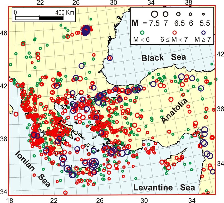
The Aegean–Hellenic system is the most seismic zone of the Mediterranean area
Publisher’s Note: MDPI stays neutral (Figure 1). Thus, there is a considerable interest in understanding which driving forces
with regard to jurisdictional claims in and tectonic processes are responsible for such activity. This basic knowledge could help
published maps and institutional affil- recognizing the connection between the ongoing deformation pattern and the spatio-
iations. temporal distribution of major earthquakes, to be used for tentatively identifying the zones
most prone to next major earthquakes (e.g., [1,2]).
The Aegean region presents a complex distribution of zones characterized by different
lithologies, structural features, morphologies, strain regimes and kinematic patterns. We
Copyright: © 2022 by the authors.
separated the evidence relating to long-term deformation (Figure 2), mainly derived by
Licensee MDPI, Basel, Switzerland.
geological or geophysical investigations, from the short-term deformations (Figure 3),
This article is an open access article
distributed under the terms and
inferred from geodetic and seismicity data. This was because the second kind of data may
conditions of the Creative Commons
relate to the transient displacement and strain fields triggered (as postseismic relaxation)
Attribution (CC BY) license (https:// by the strong earthquake sequence that has developed along the entire North Anatolian
creativecommons.org/licenses/by/ Fault system (NAF) since 1939 [17–19].
4.0/).
Geosciences 2022, 12, 104. https://doi.org/10.3390/geosciences12030104 https://www.mdpi.com/journal/geosciences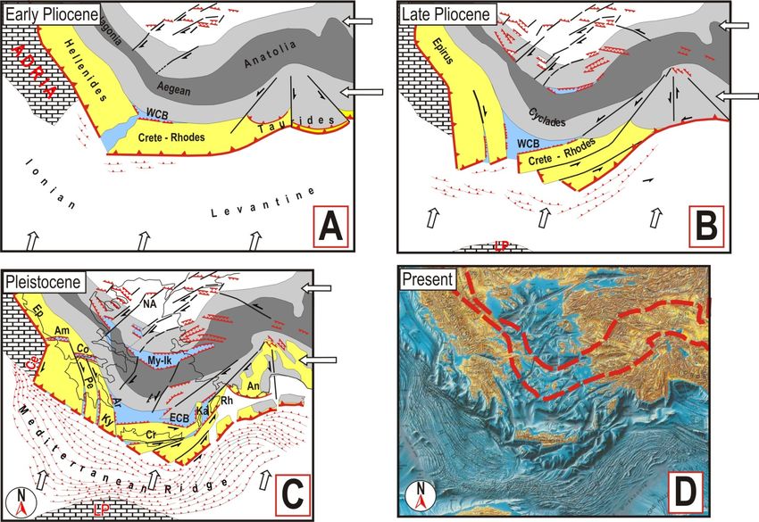
Geosciences 2022,
Geosciences 2022, 12,
                  12, 104
                      x                                                                                                       2 2of
                                                                                                                                  of 28
                                                                                                                                     28

                            Figure 1. Distribution of major earthquakes M ≥ 5.5) in the study area (since 1000 A.D.). Data from
                            Figure 1. Distribution of major earthquakes M ≥ 5.5) in the study area (since 1000 A.D.). Data
                            [3–16].
                            from [3–16].
                                   The
                                   The Aegean    region
                                        map of the  Moho presents
                                                             depth a(Figure
                                                                      complex2A)distribution   of zones
                                                                                  indicates that          characterized
                                                                                                  the thinnest     crust is by differ-
                                                                                                                            observed
                            ent  lithologies, structural   features,  morphologies,     strain regimes    and
                            in the Cretan basin, the Karpathos trough (15–20 km) and the North Aegean trough   kinematic    patterns.
                            We   separated
                            (20–25   km). ThetheCretan
                                                  evidence
                                                         andrelating   to long-term
                                                              Mykonos–Ikaria          deformation
                                                                                  basins              (Figure 2),
                                                                                           are deep troughs,        mainly
                                                                                                                  where      derived
                                                                                                                         a relatively
                            by
                            thingeological   or geophysical
                                  crustal basement    is buriedinvestigations,
                                                                 beneath a thickfrom   the short-term
                                                                                   sedimentary    coverdeformations
                                                                                                          (e.g., [24] and(Figure   3),
                                                                                                                           references
                            inferred   from  geodetic  and   seismicity  data. This  was   because the   second
                            therein). The thickest crust is observed in the Hellenides, along the Greek–Albanian   kind of  data may
                            relate
                            zone. to   the transient
                                     Seafloor         displacement
                                               bathymetry              and the
                                                              shows that    strain fields triggered
                                                                                Cyclades    sector is (as  postseismic
                                                                                                       a shallow          relaxation)
                                                                                                                    sea, with   many
                            by
                            islands where exhumed deep crustal rocks outcrop (e.g., [25] and referencesAnatolian
                                the  strong  earthquake    sequence    that has  developed    along  the   entire  North     therein).
                            Fault   system (NAF)
                            Transtensional          sincehas
                                              tectonics   1939   [17–19].in the northern Aegean zone since the late Miocene–
                                                              occurred
                            early Pliocene [26–28], while extension and subsidence have developed in the southern
                            Aegean zone since the early Pliocene in the western Cretan basin, and since the Pleistocene
                            in the eastern Cretan basin and Karpathos trough (e.g., [24,29]).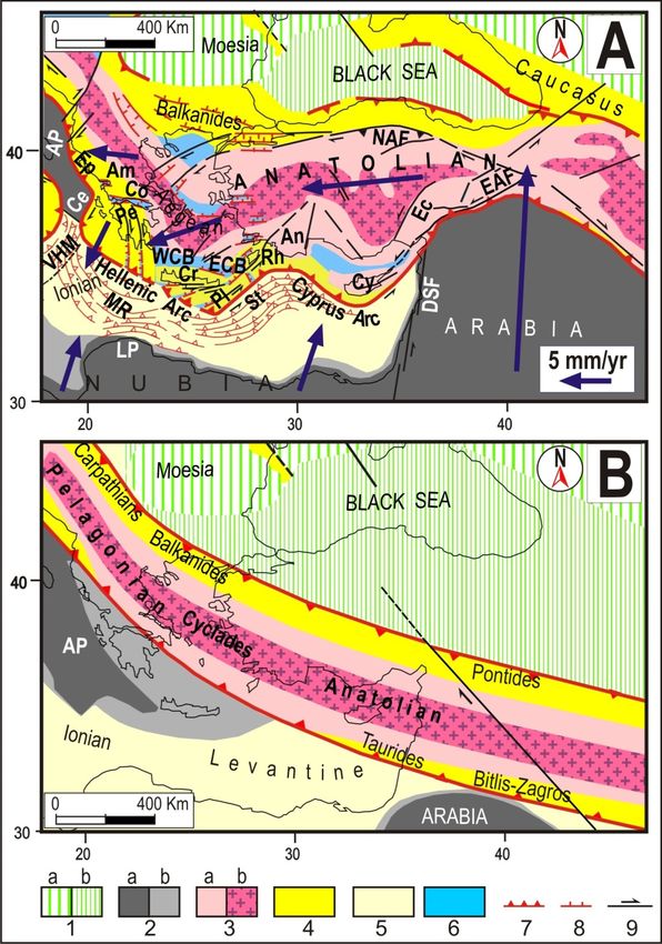
Geosciences 2022, 12, 104                                                                                                      3 of 28
   Geosciences 2022, 12, x                                                                                                 3 of 28

                              Figure2.
                             Figure   2. Main
                                         Mainlong-term
                                               long-termevidence  in the
                                                           evidence      Aegean
                                                                     in the      region.
                                                                             Aegean      (A) Map
                                                                                     region.  (A) of the Moho
                                                                                                   Map   of thedepth
                                                                                                                 Mohomodified  after
                                                                                                                       depth modified
                              [20,21]. (B) Distribution of volcanic activity modified after [22]. (C) Vertical displacement rates in
                             after [20,21]. (B) Distribution of volcanic activity modified after [22]. (C) Vertical displacement rates
                              Aegean coastal zones during the Holocene assessed by geoarchaeological data (modified after [23]).
                             in Aegean coastal zones during the Holocene assessed by geoarchaeological data (modified after [23]).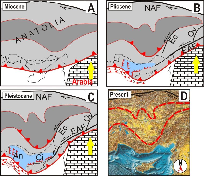
crustal basement is buried beneath a thick sedimentary cover (e.g., [24] and references
therein). The thickest crust is observed in the Hellenides, along the Greek–Albanian zone.
Seafloor bathymetry shows that the Cyclades sector is a shallow sea, with many islands
where exhumed deep crustal rocks outcrop (e.g., [25] and references therein). Transten-
sional tectonics has occurred in the northern Aegean zone since the late Miocene–early
Geosciences 2022, 12, 104 4 of 28
Pliocene [26–28], while extension and subsidence have developed in the southern Aegean
zone since the early Pliocene in the western Cretan basin, and since the Pleistocene in the
eastern Cretan basin and Karpathos trough (e.g., [24,29].
AA generalized
generalized uplift
uplift has
has affected
affected the
the Peloponnesus
Peloponnesus andand mainland
mainland Greece
Greece since
since the
the
early
early Pliocene (e.g., [30] and references therein; [31]), with Holocene uplift rates running
Pliocene (e.g., [30] and references therein; [31]), with Holocene uplift rates running
from
from 0.6
0.6 to
to1.8
1.8mm/yr
mm/yr (Figure
(Figure 2C).
2C). The
The Adriatic
Adriatic zone
zone beside
beside the
the Hellenides
Hellenides was
was folded
folded
and
and uplifted in the Pliocene. The western part of Cephalonia and the Zakynthos islands
uplifted in the Pliocene. The western part of Cephalonia and the Zakynthos islands
experienced
experienced an an uplift
uplift of
of at
at least
least several
several hundreds
hundreds ofofmeters
meters in
inthe
thePleistocene
Pleistocene[32].
[32]. Uplift
Uplift
rates of some mm/yr have been observed along the Hellenic Arc [22]. Crete underwent a
rates of some mm/yr have been observed along the Hellenic Arc [22]. Crete underwent a
~1 km uplift between 5 and 3 Ma [33–35]. The analysis of the Plio-Quaternary deformation
~1 km uplift between 5 and 3 Ma [33–35]. The analysis of the Plio-Quaternary deformation
in the central Aegean area suggests that the Cyclades massif has been simultaneously
in the central Aegean area suggests that the Cyclades massif has been simultaneously af-
affected by E-W compression and S-N extension (e.g., [36,37]).
fected by E-W compression and S-N extension (e.g., [36,37]).
Figure3.
Figure 3. Horizontal
Horizontal velocity
velocity field
field in
in the
the Anatolian
Anatolian Aegean
Aegean area,
area, defined
defined by
by geodetic
geodetic data
data (modified
(modified
after [38]).
after [38]).
The present
The present kinematic
kinematicpattern
pattern(Figure
(Figure3),3),
defined by by
defined geodetic observations
geodetic (GPS,
observations e.g.,
(GPS,
[38–40]) shows that Anatolia is moving roughly westward at 15 to 25 mm/yr
e.g., [38–40]) shows that Anatolia is moving roughly westward at 15 to 25 mm/yr relativerelative to
Eurasia, while the southern Aegean (and much of the Peloponnesus) moves
to Eurasia, while the southern Aegean (and much of the Peloponnesus) moves SW-ward SW-ward at
30–35 mm/yr. A strong reduction in velocities occurs north of the North
at 30–35 mm/yr. A strong reduction in velocities occurs north of the North Aegean Aegean trough.
In the southern
trough. and western
In the southern Peloponnesus,
and western GPS dataGPS
Peloponnesus, suggest
data5suggest
mm/yr of E-W extension.
5 mm/yr of E-W
In central In
extension. Greece,
centralthe extensional
Greece, trend turns
the extensional trendtoturns
S-N to(5–20
S-N mm/yr), being most
(5–20 mm/yr), being likely
most
likely responsible for the generation of E-W troughs, such as the Corinth and Ambracique
troughs (e.g., [21,41–43]. In southwestern Anatolia, the velocity field suggests a WNW-ESE
extensional rate of 5 mm/yr.
In mainland Greece and western Anatolia, the analysis of focal mechanisms indicates
an S-N extensional regime, associated with E-W compression (e.g., [38]). Strike-slip fault-
ing is documented in the North Anatolian fault (NAF), while reverse faulting occurs in
the Hellenic Trench, the Ionian Sea off western Greece and northwest into Epirus and
Albania (e.g., [22]).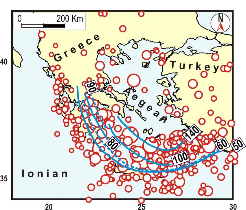
In mainland Greece and western Anatolia, the analysis of focal mechanisms indicates
an S-N extensional regime, associated with E-W compression (e.g., [38]). Strike-slip fault-
ing is documented in the North Anatolian fault (NAF), while reverse faulting occurs in
the Hellenic Trench, the Ionian Sea off western Greece and northwest into Epirus and
Geosciences 2022, 12, 104 Albania (e.g., [22]). 5 of 28
The strongest and most frequent seismicity (Figure 1) affects the entire Hellenic arc,
with particular regard to the boundary between the Hellenides and the Adriatic plate.
IntenseThe
activity also and
strongest affects
most western
frequentAnatolia and
seismicity the northern
(Figure 1) affectsAegean trough.
the entire The
Hellenic Cycla-
arc,
deswith particular
massif in the regard
centraltoAegean
the boundary
region between theby
is affected Hellenides and the
minor crustal Adriatic and
seismicity plate.a low
Intense
strain rateactivity also affects western Anatolia and the northern Aegean trough. The Cyclades
(e.g., [38]).
massif in the central Aegean region is affected by minor crustal seismicity and a low strain
The occurrence of subcrustal earthquakes under the Aegean zone (down to about 150
rate (e.g., [38]).
km) and the geometry of the Hellenic accretionary chain indicate the presence of sub-
The occurrence of subcrustal earthquakes under the Aegean zone (down to about
ducted lithosphere.
150 km) The shape
and the geometry of this
of the bodyaccretionary
Hellenic has been tentatively reconstructed
chain indicate the presence byofmany
authors [44,45]. A recent slab geometry, suggested by [46], is shown in Figure
subducted lithosphere. The shape of this body has been tentatively reconstructed by many 4.
authors [44,45]. A recent slab geometry, suggested by [46], is shown in Figure 4.
Figure 4. Distribution of subcrustal earthquakes (h > 30) and tentative reconstruction of the Hellenic
Figure 4. Distribution of subcrustal earthquakes (h > 30) and tentative reconstruction of the Hellenic
slab (isodepth lines from [46] and references therein).
slab (isodepth lines from [46] and references therein).
The present
The presentconfiguration of the
configuration of themain
mainlithological
lithological domains
domains (Figure
(Figure 5A) 5A) suggests
suggests that that
thethe
Aegean
Aegeanzone
zoneisisaastrongly deformedsector
strongly deformed sectorofofthethe long
long orogenic
orogenic system
system that that
in thein the
Oligocene
Oligocene was
was runningfrom
running from the
the Iranian–Anatolian
Iranian–Anatolian toto the Carpathian
the Carpathian regions (Figure
regions 5B). 5B).
(Figure
This
This system
system is constituted
is constituted byby
anan innermetamorphic
inner metamorphiccrystalline
crystalline belt,
belt, generated
generated byby the
the con-
consumption of the northern NeoTethys oceanic domain, flanked by two external
sumption of the northern NeoTethys oceanic domain, flanked by two external neogenic neogenic
accretionary belts of European and African affinity ([47–52] and references therein; [53–55]).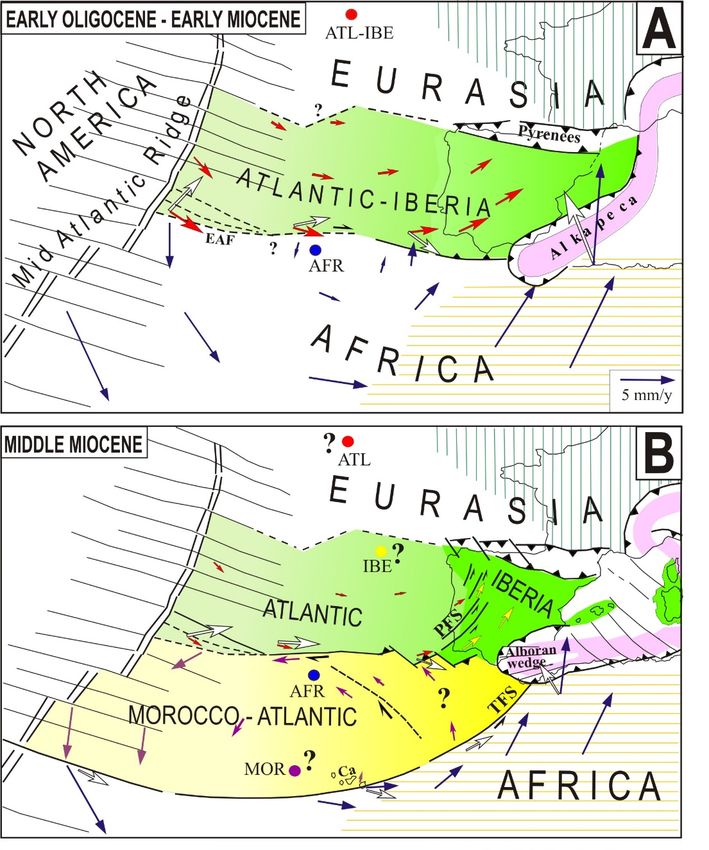
Geosciences 2022, 12, x 6 of 28
Geosciences 2022, 12, 104 6 of 28
accretionary belts of European and African affinity ([47–52] and references therein; [53–
55]). Some authors, on the basis of tomographic data, suggest that the subduction of the
AfricanSome authors,
margin on the basis of tomographic
(Ionian–Levantine domain)data,
undersuggest that the subduction
the Aegean arc startedofinthe
the Meso-
zoic (e.g., [56,57]), whereas a much later onset (middle Mioceneinto
African margin (Ionian–Levantine domain) under the Aegean arc started theearly
Mesozoic
Pliocene) of
(e.g., [56,57]), whereas a much later onset (middle Miocene to early Pliocene) of this con-
this consuming process has been proposed by other authors [46,58–62]. Most recon-
suming process has been proposed by other authors [46,58–62]. Most reconstructions of
structions of the Aegean area preceding the subduction suggest an almost rectilinear
the Aegean area preceding the subduction suggest an almost rectilinear boundary
boundary [31,46,56,63–65], implying a subsequent bowing of the Aegean arc.
[31,46,56,63–65], implying a subsequent bowing of the Aegean arc.
Figure 5. (A) Present tectonic setting. (1) Continental (a) and thinned continental (b) Eurasian do-
Figure 5. (A) Present tectonic setting. (1) Continental (a) and thinned continental (b) Eurasian
mains. (2) Continental (a) and thinned continental (b) African, Adriatic and Arabian domains. (3)
domains. (2)the
Inner core of Continental
Tethyan belt,(a)constituted
and thinned continental
by ophiolitic units(b)
(a) African, Adriatic
and crystalline and(b).
massifs Arabian
(4) Ex- domains.
(3) Inner
ternal core of the
accretionary beltsTethyan belt, constituted
with European and African by ophiolitic
affinity. units
(5) Ionian and(a) and crystalline
Levantine massifs (b).
oceanic do-
mains.
(4) (6) Zones
External affected by
accretionary crustal
belts withthinning.
European(7–9)
andCompressional,
African affinity.tensional and strike-slip
(5) Ionian fea- oceanic
and Levantine
tures. The blue
domains. (6) vectors
Zones indicate
affectedthebylong-term kinematic pattern
crustal thinning. [66,67]. The presenttensional
(7–9) Compressional, shape andand
com-strike-slip
position of the Tethyan belt was taken from [68–70]. Am—Ambracique trough; AP—Adriatic plate;
features.
An—Antalya;The Ce—Cephalonia
blue vectors indicate the long-term
fault system; Co—Corinthkinematic
trough;pattern
Cr—Crete; [66,67]. The present
Cy—Cyprus; DSF—shape and
composition
Dead Sea faultofsystem;
the Tethyan belt was
EAF—East takenfault;
Anatolian fromEc—Ecemis
[68–70]. Am—Ambracique trough; AP—Adriatic
fault; Ep—Epirus; ECB—eastern
CretanAn—Antalya;
plate; basin; LP—Libyan promontory; MR—Mediterranean
Ce—Cephalonia ridge; NAF—North
fault system; Co—Corinth Anatolian fault;
trough; Cr—Crete; Cy—Cyprus;
Pe—Peloponnesus;
DSF—Dead Sea faultPl—Pliny
system;fault; Rh—Rhodes;
EAF—East St—Strabo
Anatolian fault; WCB—western
fault; Ec—Ecemis Cretan basin
fault; Ep—Epirus; ECB—eastern
Cretan basin; LP—Libyan promontory; MR—Mediterranean ridge; NAF—North Anatolian fault;
Pe—Peloponnesus; Pl—Pliny fault; Rh—Rhodes; St—Strabo fault; WCB—western Cretan basin
VHM—Victor–Hensen Medina fault system. (B) Tentative reconstruction of the Oligocene–early
Miocene configuration of the Tethyan belt and surroundings.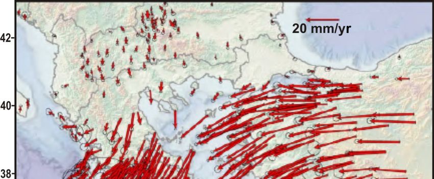
VHM—Victor–Hensen Medina fault system. (B) Tentative reconstruction of the Oligocene–early
Miocene configuration of the Tethyan belt and surroundings.
2. Late Cenozoic Evolution
The shortening between the Arabian promontory and Eurasia started more than 30
Geosciences 2022, 12, 104 7 of 28
Ma, accommodated by the closure of an ancient ocean, the Neotethys [71,72]. During this
phase, a major NW-SE dextral transpressional fault decoupled the Anatolian sector of the
Tethyan belt from the Iranian sector (Figure 5B, [48,51,73–75]. Some authors [76,77] sug-
2.gest
Late Cenozoic
that Evolutionof Arabia occurred much later (late Miocene–early Pliocene),
the indentation
supposing that such
The shortening between an eventthe wasArabian
responsible for the thrusting
promontory and Eurasia andstarted
uplift in the than
more Bitlis
suture
30 zone. However,by
Ma, accommodated such
the aclosure
hypothesis cannot explain
of an ancient ocean, thewhy, since the[71,72].
Neotethys early Miocene
During
shortening
this phase, aoccurred
major NW-SE north of the Bitlis
dextral zone, in the fault
transpressional Pontides, Caucasus,
decoupled Carpathians
the Anatolian and
sector
of the Tethyan
Magura zonesbelt(e.g.,from the Iranian sector (Figure 5B, [48,51,73–75]. Some authors [76,77]
[48,51,52,67,73,78–81].
suggest thatsuch
Once the indentation
thinned domains of Arabia
wereoccurred
mostly much later (late
consumed, about Miocene–early
12–15 Ma, the Pliocene),
Arabia–
supposing that such ancaused
Eurasia convergence event was responsibleuplift
a considerable for theandthrusting and upliftdeformations
compressional in the Bitlis suture
in the
zone. However, such a hypothesis cannot explain why, since the
Tethyan belt, forming the Anatolian plateau (e.g., [76,82–84]. This shortening producedearly Miocene shortening
occurred north of the Bitlis
major palaeogeographic, zone, in the Pontides,
sedimentological and tectonic Caucasus,
changes Carpathians and Magura
[85,86], accompanied by
zones
volcanic(e.g., [48,51,52,67,73,78–81].
activity [76,87], in eastern Turkey (Figure 6). Then, the gradual increase in re-
Onceagainst
sistance such thinned
any furtherdomains were mostly
shortening led to theconsumed,
activation about 12–15decoupling
of lateral Ma, the Arabia–
faults,
Eurasia
which allowed the eastern Anatolian wedge to extrude westward [48,51,73,74,81]. Thethe
convergence caused a considerable uplift and compressional deformations in on-
Tethyan belt, forming
set of sliding along thethe Anatolian
North plateau
Anatolian fault(e.g.,
(NAF) [76,82–84].
is mostly This
placed shortening
in the lateproduced
Miocene,
major
while palaeogeographic,
this onset for the East sedimentological
Anatolian fault and(EAF)tectonic changesplaced
is generally [85,86],much
accompanied
later (late
by volcanic activity [76,87], in eastern Turkey (Figure 6). Then,
Pliocene, e.g., [88–90] and references therein). To tentatively explain this considerablethe gradual increasemis- in
resistance
match betweenagainst anyonset
such further shortening
times, led tothat
[91] suggests the the
activation
activationof lateral decoupling
of the EAF faults,
was preceded
which allowed the eastern Anatolian wedge to extrude westward [48,51,73,74,81].
by the activation of other transpressional faults parallel to the EAF, but located more The onset to
of sliding along the North Anatolian fault (NAF) is
the west (in particular, the Ovacik and Ecemis faults, Figure 7). mostly placed in the late Miocene, while
this onset for theobservations
Geological East Anatolian fault (EAF)
suggest that iniscentral
generally placedthe
Anatolia, muchNAF later (late Pliocene,
activated around
e.g., [88–90] and references therein). To tentatively explain
8.5 Ma [89,90] and around 5 My in its western part, around the Sea of Marmara this considerable mismatch
[27,92].
between
During thissuchphase,
onset thetimes, [91] suggests
westward thatof
extrusion the activation
Anatolia wasofaccommodated
the EAF was preceded by the
by the roughly
activation of other transpressional faults parallel to the EAF,
SW-ward bending of the western Anatolian–Aegean–Pelagonian Tethyan belt, at the but located more to the west
ex-
(in particular, the Ovacik and Ecemis faults, Figure 7).
pense of the Levantine, Ionian and Pindos thinned domains.
Figure6.6.Middle
Figure MiddleMiocene
Miocenepaleogeographic
paleogeographicsetting.
setting.Present
Presentgeographical
geographicalcontours
contours(thin
(thinblack
black lines)
lines)
are reported for reference. The kinematics with respect to a Eurasian reference frame [66,67] are
are reported for reference. The kinematics with respect to a Eurasian reference frame [66,67] are
tentatively indicated by the blue arrows (scale in the inset). Pi—Pindos zone. Symbols, colors and
other abbreviations as in Figure 5.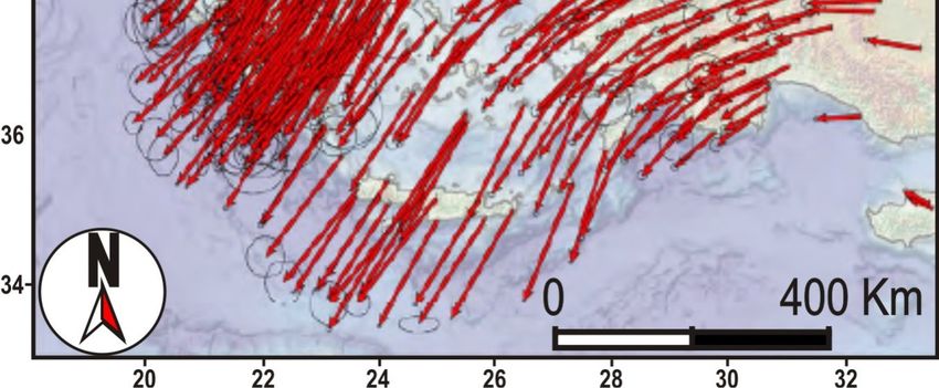
other abbreviations as in Figure 5.
This context went on until the late Miocene–early Pliocene (Figure 7), when the west-
ern Aegean Tethyan belt collided with the continental part of the Adriatic domain, after
the complete consumption of the thinned Pindos zone. Initially, this collision caused a
Geosciences 2022, 12, 104 8 of 28
shortening and uplift in both the colliding structures, evidenced by the inversion of pre-
vious normal faults in the Ionian domain during the Tortonian–late Messinian interval
(e.g., [93]) and by a thrusting and uplift in the western Aegean zone (Central Greece,
Geological
[94,95]). observations
Once having suggest
consumed the that in central
thinned Anatolia,
domains, the NAF
the strong activated
increase in E-W around
com-
8.5
pression accelerated the southward oroclinal bending of the Aegean Tethyan belt,[27,92].
Ma [89,90] and around 5 My in its western part, around the Sea of Marmara at the
During
expensethisof phase, the westward
the Levantine extrusion
and Ionian of Anatolia
oceanic domains was accommodated
(e.g., [96–98]). Thisbyconsumption
the roughly
SW-ward
process led to the formation of the Mediterranean ridge accretionary complex at
bending of the western Anatolian–Aegean–Pelagonian Tethyan belt, the ex-
along the
pense of the Levantine, Ionian and Pindos thinned
outer boundary of the entire Hellenic arc (Figure 8). domains.
Figure7.7. Late
Figure Late Miocene–early
Miocene–earlyPliocene
Pliocenepaleogeographic
paleogeographicsetting,
setting,preceding
precedingthe
thecollision
collisionbetween
betweenthe
the
Aegean Tethyan belt and Adria. Ec—Ecemis fault; Ov—Ovacik fault. Symbols, colors and
Aegean Tethyan belt and Adria. Ec—Ecemis fault; Ov—Ovacik fault. Symbols, colors and otherother ab-
breviations as in Figure 5.
abbreviations as in Figure 5.
Due context
This to their went
different rheological
on until the late behaviour, the belts
Miocene–early constituting
Pliocene (Figurethe 7),Aegean
when the arc
underwent different deformation patterns in response to the E-W compression.
western Aegean Tethyan belt collided with the continental part of the Adriatic domain, The inner,
mainly
after the ductile,
complete core (Cycladic arc)
consumption of theunderwent a southward
thinned Pindos bowing
zone. Initially, without
this major
collision causedfrag-
a
mentations,
shortening andwhereas
uplift inthe outer
both brittle belt
the colliding (Hellenic
structures, arc), being
evidenced affected
by the by intense
inversion belt-
of previous
parallelfaults
normal tensional
in thestresses in its most
Ionian domain curved
during the sector, broke inMessinian
Tortonian–late two branches: the(e.g.,
interval Pelopon-
[93])
nesus and Crete–Rhodes (Figure 8). After separation, these belt sectors
and by a thrusting and uplift in the western Aegean zone (Central Greece, [94,95]). Once progressively re-
leased their previous horizontal flexure, by clockwise (Peloponnesus)
having consumed the thinned domains, the strong increase in E-W compression accelerated and counter-clock-
wise
the (Crete–Rhodes)
southward oroclinal rotations,
bendingrespectively.
of the AegeanThe divergence
Tethyan belt, atbetween these
the expense of migrating
the Levantinesec-
torsIonian
and and theoceanic
inner Cyclades
domains massif inducedThis
(e.g., [96–98]). extension in the interposed
consumption process led zone. This
to the tectonic
formation
mechanism
of may explain
the Mediterranean ridgewhy crustal thinning,
accretionary complexwithalong a dominant S-N extensional
the outer boundary trend,
of the entire
occurredarc
Hellenic in (Figure
the western
8). Cretan basin (WCB) from the late Miocene to the late Pliocene
[26,99–102], and why
Due to their such arheological
different regime only affected athe
behaviour, limited,
belts almost triangular
constituting zone arc
the Aegean
(Figure 8). different deformation patterns in response to the E-W compression. The inner,
underwent
mainlyTheductile, core (Cycladic
hypothesis about the arc) underwent
mainly ductilea southward
behaviour of bowing without
the inner majorbelt
Tethyan fragmen-
is pri-
tations,
marily whereas
suggested thebyouter brittle belt
the present (Hellenic
shape of thisarc), being affected
structure, by intense
characterized by thebelt-parallel
continuity
tensional stresses in its most curved sector, broke in two branches: the Peloponnesus and
Crete–Rhodes (Figure 8). After separation, these belt sectors progressively released their
previous horizontal flexure, by clockwise (Peloponnesus) and counter-clockwise (Crete–
Rhodes) rotations, respectively. The divergence between these migrating sectors and the
inner Cyclades massif induced extension in the interposed zone. This tectonic mechanism
may explain why crustal thinning, with a dominant S-N extensional trend, occurred in the
western Cretan basin (WCB) from the late Miocene to the late Pliocene [26,99–102], and
why such a regime only affected a limited, almost triangular zone (Figure 8).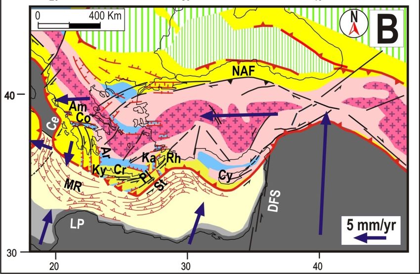
Geosciences 2022, 12, x 9 of 28
Geosciences 2022, 12, 104 9 of 28
and major bendings. Since that belt generated along the boundary of an oceanic domain,
it seems unlikely that its present strongly deformed shape was the original one.
Figure 8.
Figure 8. Middle
Middle Pliocene
Pliocene tectonic
tectonic setting.
setting. AC—Antalia–Cilicia
AC—Antalia–Cilicia basin;
basin; Am—Ambracique
Am—Ambracique trough;
trough;
Ce—Cephalonia fault; Co—Corinth trough; CR—Crete–Rhodes (eastern Hellenic arc); Cy—Cyprus;
Ce—Cephalonia fault; Co—Corinth trough; CR—Crete–Rhodes (eastern Hellenic arc); Cy—Cyprus;
EAF—East Anatolian fault system; Ep—Epirus; LP—Libyan promontory; MR—Mediterranean
EAF—East Anatolian fault system; Ep—Epirus; LP—Libyan promontory; MR—Mediterranean ridge;
ridge; NA—North Aegean trough; Pe—Peloponnesus; WCB—western Cretan basin; VHM—Victor
NA—North Aegean
Hensen-Medina trough;
fault. Pe—Peloponnesus;
Symbols colors and otherWCB—western Cretan
abbreviations as basin;5 VHM—Victor
in Figure and Figure 7. Hensen-
Medina fault. Symbols colors and other abbreviations as in Figures 5 and 7.
The hypothesis that the Tethyan belt transmitted the westward push of the Anatolian
The hypothesis about the mainly ductile behaviour of the inner Tethyan belt is pri-
wedge to the Adriatic–Hellenides structures is suggested by the shortening that these
marily suggested by the present shape of this structure, characterized by the continuity
zones underwent since the middle–late Miocene, involving a thrusting and uplift (e.g.,
and major bendings. Since that belt generated along the boundary of an oceanic domain, it
[94,103–105]) and a clockwise rotation of about 40° of northern Hellenides between 15–13
seems unlikely that its present strongly deformed shape was the original one.
and 8 Ma [57,106]. The analysis by [57] excludes the possibility that significant paleomag-
The hypothesis that the Tethyan belt transmitted the westward push of the Anatolian
netic rotations occurred before 15 Ma. In the Pliocene, the convergence between the Cy-
wedge to the Adriatic–Hellenides structures is suggested by the shortening that these zones
cladic arc and Adria caused the southward escape of the Peloponnesus wedge and the
underwent since the middle–late Miocene, involving a thrusting and uplift (e.g., [94,103–105])
formation of E-W troughs, such as the Corinth and Ambracique ones (Figure 5,
and a clockwise rotation of about 40◦ of northern Hellenides between 15–13 and 8 Ma [57,106].
[41,52,107,108]).
The analysis by [57]The excludes
above compressional
the possibility context is still active,
that significant as suggested
paleomagnetic by the oc-
rotations oc-
currence of strong and frequent seismic activity, characterized
curred before 15 Ma. In the Pliocene, the convergence between the Cycladic arc and by compressional and
transpressional
Adria caused themechanisms ([67] and
southward escape references
of the therein).
Peloponnesus wedge and the formation of E-W
The divergence between the southward
troughs, such as the Corinth and Ambracique ones (Figure bowing Aegean 5, arc and Rodope can
[41,52,107,108]). Theexplain
above
why in the North Aegean and northwestern Anatolian zones transtensional
compressional context is still active, as suggested by the occurrence of strong and frequent tectonics ac-
celerated
seismic in the characterized
activity, Pliocene, withby the formation of and
compressional dextral fault systems,
transpressional purely transcurrent
mechanisms ([67] and
to the east and
references therein).prevailingly extensional to the west (e.g., [26,29,109–112,113] and refer-
encesThe
therein).
divergence between the southward bowing Aegean arc and Rodope can ex-
plain whyslip
The in rate along the
the North NAF and
Aegean faultnorthwestern
system increased from about
Anatolian zones3transtensional
mm/yr in the late tec-
Miocene
tonics to about 20
accelerated inmm/yr in the last
the Pliocene, with2.5–3
theMa [91]. Thisofacceleration
formation dextral fault could be duepurely
systems, to the
activation of to
transcurrent thethe
eastern Anatolian
east and fault extensional
prevailingly system (e.g.,to[88,89,91]), which
the west (e.g., allowed the com-
[26,29,109–113] and
plete decoupling
references therein).of the Anatolian wedge from Arabia and/or to the fact that the progres-
sive The
southward
slip ratebending
along theof NAF
the Aegean arc reduced
fault system increasedthe from
resistance
aboutagainst
3 mm/yr the inwestward
the late
displacement of Anatolia, favouring the activation of decoupling
Miocene to about 20 mm/yr in the last 2.5–3 Ma [91]. This acceleration could fault systems in be
eastern
due
Anatolia.
to the activation of the eastern Anatolian fault system (e.g., [88,89,91]), which allowed
During the
the complete Pliocene, of
decoupling thethe
Cyclades
Anatolianmassif
wedgewas from
affected by anand/or
Arabia intensetocompressional
the fact that
deformation
the progressive andsouthward
uplift, which produced
bending of thethe first deposition
Aegean arc reduced of continental facies,
the resistance after the
against the
Miocene marine
westward sedimentation
displacement [26,95,114].
of Anatolia, favouringLarge-scale overturned
the activation and upright
of decoupling folds
fault with
systems
in eastern Anatolia.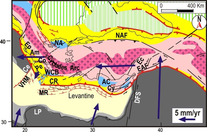
Geosciences 2022, 12, 104                                                                                           10 of 28

                                  During the Pliocene, the Cyclades massif was affected by an intense compressional
                            deformation and uplift, which produced the first deposition of continental facies, after the
                            Miocene marine sedimentation [26,95,114]. Large-scale overturned and upright folds with
                            axes parallel to the extensional trend (roughly S-N) have been recognized in the Cyclades
                            islands (e.g., [36,115]). The fact that in this zone several Ma of crustal stretching failed to
                            produce any net crustal thinning was interpreted by [36] as an effect of contemporaneous
                            thickening caused by E-W shortening, through the exhumation of lower crustal mate-
                            rial [116]. The simplest explanation of the above features in the Cyclades zone involves
                            the E-W compression induced by the westward escape of Anatolia, as suggested by other
                            authors (e.g., [59,117,118]).
                                  After their separation, the eastern and western Hellenic arcs underwent different
                            deformation patterns (Figure 9A,B). In Greece, the E-W compression between the Cycladic
                            arc and the continental Adriatic domain caused a marked uplift and roughly southward
                            escape of narrow crustal wedges (slices) in the Peloponnesus, at the expense of the Ionian
                            and Levantine oceanic domains. The S-N extension induced by the divergence between
                            mainland Greece and the escaping Peloponnesus wedges generated the Corinth and Am-
                            bracique troughs (e.g., [108,119]). Since the compressional context was exerted by two
                            different converging structures, the Cycladic arc on one side and the shorter Adria southern
                            boundary (Cephalonia fault) on the other side, the E-W compression was accompanied
                            by a clockwise torsion. This mechanism may explain the angular divergence and dextral
                            shear that formed some longitudinal troughs in the southern Peloponnesus (e.g., [119–121]).
                            The dextral Cephalonia transpressional fault marks the overthrusting of the Peloponnesus
                            wedge on the southernmost Adriatic continental domain (e.g., [26,122,123]).
                                  The bending of the Aegean arc was not the only effect of the enhanced E-W compres-
                            sion that followed the late Miocene–early Pliocene collision of the Aegean Tethyan belt
                            with the continental Adriatic domain. This acceleration also produced further southward
                            bending of the eastern Anatolian Tethyan belt (Figures 8 and 9). The timing of this de-
                            formation is suggested by the fact that the late Miocene compressional and extensional
                            deformation patterns, respectively, occurred along the outer and inner sides of the Cyprus
                            arc (e.g., [124–126]). This inference is based on the hypothesis that the detachment of the
                            Cyprus wedge from Anatolia, with the formation of the Antalya and Cilicia basins, was
                            determined by the belt-parallel extensional stress that occurred in the outermost sector of
                            the Tethyan belt in response to bending (Figure 8). Belt-parallel stress in the outer belt also
                            caused the thinning and subsidence of the narrow land strip connecting the Cyprus arc to
                            easternmost Anatolia.
                                  In the central Mediterranean region, the late Miocene collision of the Tethyan belt with
                            the continental Adriatic domain caused a major reorganization of the tectonic context, as
                            extensively described by [127,128].
                                  In the late Pliocene, the deformation pattern of the Hellenic arc underwent a major
                            change, due to the collision of Crete with the Libyan promontory, as suggested by geological
                            and morphological evidence [129–132]. After this contact, the Crete–Rhodes sector, stressed
                            by the convergence between southwestern Anatolia and Nubia, underwent SE-ward bend-
                            ing at the expense of the Levantine domain (Figure 9B). This mechanism was probably
                            responsible as well for the land interruption between Crete and Rhodes [41,102,133]. The
                            extension that developed in the wake of the SE-ward bending Crete–Rhodes sector formed
                            the eastern Cretan basin and the Karpathos trough (Figure 9B). Since the resistance of
                            the Libyan promontory only acted on the southern part of the Cretan wedge, the SW-NE
                            compression was associated with a sinistral shear, which caused the slicing of that wedge,
                            involving a faster westward motion of the northernmost slice (Crete island), with respect
                            to the southern slices (Figure 9B). The sinistral relative motion between those slices was
                            allowed by the Pliny and Strabo sinistral strike-slip major faults.
deformation regime dominated by SW-ward extensional and E-W compressional forces,
as confirmed by the main features of the strong 2006 earthquake in the Kythira strait. The
analysis of the microseismicity related to subcrustal earthquakes along the Hellenic arc
(e.g., [134–136]) suggests that the downgoing slab is considerably contorted. Such an in-
terpretation agrees with the results of [138], who observed an undulating topography of
Geosciences 2022, 12, 104 11 of 28
the African plate Moho beneath western Crete after an analysis of the migrated receiver
functions.
Figure 9.
Figure 9. (A)
(A) Late
LatePliocene
Pliocenepaleogeographic
paleogeographic configuration.
configuration. AC—Antalya–Cilicia
AC—Antalya–Cilicia basin;
basin; Ce—Ceph-
Ce—Cephalonia
alonia fault; Co—Corinth trough; DFS—Dead Sea fault system; ECB—eastern Cretan
fault; Co—Corinth trough; DFS—Dead Sea fault system; ECB—eastern Cretan basin; EAF—East basin; EAF—
East Anatolian fault system; LP—Libyan promontory; MR—Mediterranean ridge; NAF—North An-
Anatolian fault system; LP—Libyan promontory; MR—Mediterranean ridge; NAF—North Anato-
atolian fault system; Pl and St—Pliny and Strabo faults; VHM—Victor Hensen-Medina fault system.
lian fault system; Pl and St—Pliny and Strabo faults; VHM—Victor Hensen-Medina fault system.
(B) Late Pleistocene paleogeographic setting. Am—Ambracique trough; Ar—Argolides trough;
Cr—Crete island; Ka—Karpathos trough; Ky—Kythira slice; Rh—Rhodes. Colors, other symbols and
abbreviations as in Figures 5 and 8.
During this phase, the Crete slice (pushed roughly westward) collided with the Kythira
slice of Peloponnesus, causing its clockwise rotation and the consequent formation of the
Argolides trough (Figure 9). This context may explain the intense uplift recognized in the
colliding structures (Crete and Kythira, Figure 2C) and may have favoured the clockwise
rotation of southern Peloponnesus as well. The authors of [133] suggest that the onset of
this rotation shows a remarkable coincidence with the change in stress regime between 0.8Geosciences 2022, 12, 104 12 of 28
and 0.3 Ma that affected the Aegean region and with the coeval uplift of the entire Aegean
outer-arc (Figure 2C).
The focal mechanisms of subcrustal earthquakes [44,134–137] indicate a complex slab
deformation regime dominated by SW-ward extensional and E-W compressional forces,
as confirmed by the main features of the strong 2006 earthquake in the Kythira strait.
The analysis of the microseismicity related to subcrustal earthquakes along the Hellenic
arc (e.g., [134–136]) suggests that the downgoing slab is considerably contorted. Such
an interpretation agrees with the results of [138], who observed an undulating topogra-
phy of the African plate Moho beneath western Crete after an analysis of the migrated
receiver functions.
3. Alternative Geodynamic Interpretations
Since a reliable recognition of tectonic settings in the study area may be very useful
for various purposes, also involving social objectives as the estimate of seismic hazard,
we think that any presentation of a new geodynamic hypothesis should be integrated by
a description of the possible weaknesses of the main previous interpretations. This may
help the identification of a widely accepted opinion about the tectonic setting responsible
for seismic activity, which could be used for a tentative recognition of the time–space
distribution of major earthquakes [1,2].
3.1. Slab-Pull Model
This hypothesis suggests that the southward migration of the Aegean–Hellenic arc
was driven by the retreat of the Ionian–Levantine slab (e.g., [56,63,139,140]). However, the
implications of this hypothesis cannot easily be reconciled with some major features of the
observed deformation pattern, as discussed in the following:
In the middle–late Miocene, the present slab, identified by the distribution of sub-
crustal earthquakes, was not sufficiently developed for generating a sufficient slab-pull
force. Thus, the slab-pull model relies on the hypothesis that, in the Miocene, there was
a previous well-developed subducted lithosphere. The presence of such a slab is mainly
supported by tomographic investigations (e.g., [56,63,141–143]). However, one should
explain why that presumed lithospheric body is not affected by seismic activity. Whatever
hypothesis is advanced to justify the lack of earthquakes deeper than 160 km, it remains
to understand why under the southern Tyrrhenian, where there is a slab generated by the
subduction of the same oceanic domain, strong earthquakes occur down to depths greater
than 450 km. Insights into the possible uncertainties of tomographic data may also be
achieved by the comparison of the deep structural settings derived from different kinds
of investigation in the Northern Tyrrhenian-Apennine zone ([144–149]). To understand
the real evolution of the subduction process under the Aegean zone, it may be useful
taking into account some major aspects of the previous (Eocene–Oligocene) Mediterranean
evolution, as discussed by [127,128], in particular the fact that during the long phase of
collision between the Africa/Adriatic promontory and Eurasia, the Tethys oceanic domain
(located between continental domains) did not undergo any subduction. This kind of
behaviour, recognized in other parts of the world (e.g., [150–152]), means that the consump-
tion of oceanic lithosphere may not simply occur as an effect of plate convergence. This
behaviour is a consequence of the fact that, in geological time intervals, a mature oceanic
lithosphere is characterized by a horizontal compressional strength larger than one of a
continental domain, as indicated by long-term rheological profiles (e.g., [153]). However,
to explain why in the Neogene the subduction of oceanic domains (Alpine and Ionian
Tethys) took place in various Mediterranean zones, it is necessary to recognize what were
the conditions that allowed such a process to occur. Since all-consuming processes in that
period occurred below extruding orogenic wedges (e.g., [127,128]), one can suppose that
the starting of subductions was favoured by the load of orogenic extruded material. This
overload may have perturbed the previous equilibrium in the collision zone, triggering the
subduction of the denser oceanic lithosphere [154,155]. Numerical experiments (e.g., [156])Geosciences 2022, 12, 104 13 of 28
and laboratory modelling (e.g., [154,155,157–160]) have shown that in collisional contexts,
the lateral escape of buoyant orogenic wedges is the most convenient shortening process
and that crustal extension may develop in the wake of a migrating arc.
The above considerations suggest that the consumption of the Ionian and Levantine
oceanic domains in front of the Aegean arc started in the early–middle Miocene, when the
Tethyan belt (stressed by the Arabian indenter) began its SW-ward bending. A significant
acceleration of this process occurred around the late Miocene–early Pliocene when the
Aegean sector of that belt collided with the Adria continental domain. This interpretation
is compatible with the onset time of the Aegean subduction suggested by other authors
(e.g., [58–62,112]) on the basis of geological and geophysical observations and of the Plio-
Quaternary age of the volcanic arc (Figure 2C).
In our view, the hypothesis that the Aegean subduction started much earlier [141–143]
should be accompanied by the identification of the extrusion process that may have trig-
gered such a consumption. In this regard, it is worth noting that despite the strong com-
pression which stressed the Levantine basin for tens of My, that domain did not undergo
any subduction under the Nubian continental domain.
1. Another major problem of the slab-pull model is the fact that, since the late Miocene,
the zone running from central Greece to Albania has been affected by strong E-W com-
pressional deformation, such as crustal thickening and a strong uplift
(e.g., [94,103–105]), which is considered to be responsible for the southward escape of
the Peloponnesus wedge and for the formation of E-W troughs, such as the Corinth
and Ambracique ones (Figure 5, [41,52,107,108]). This compressional stress regime is
still going on, as testified by the strong and frequent seismic activity characterized
by compressional and transpressional mechanisms ([67] and references therein). The
above evidence can hardly be reconciled with an SW-ward pull, whereas it can simply
be interpreted as a consequence of the E-W convergence between the Cycladic arc and
the Adriatic continental domain.
2. The present shape of the inner metamorphic core of the Tethyan belt does not show any
significant interruption or thinning in the Aegean and Anatolian sectors (Figure 5A).
This structural continuity would imply that the retreat of the Hellenic slab did not
only pull the Aegean sector of the belt, it would have also pulled the entire Anatolian
body, a result that cannot easily be imputed to the retreat of a relatively narrow slab.
3. The marked oroclinal bendings of the Aegean arc (Figure 5A) can hardly be explained
as an effect of a pull. This deformation would have required a much faster trench
retreat in the central part of the arc with respect to the lateral sectors, implying a very
peculiar shape of the sinking slab. Conversely, the bowing can easily be interpreted
as an effect of the E-W compression induced by the convergence between eastern
Anatolia and the Adriatic continental domain.
4. The numerical modelling of slab-pull processes [161–163] suggests that when a realis-
tic parametrization of the overriding plate is adopted, the slab-pull force cannot cause
the break of that plate and, thus, the development of the back arc basin.
5. The complex space–time distribution of Plio-Quaternary strain regimes in the Aegean
zone is rather different from the one that usually develops in a back arc
basin ([24,25,67] and references therein). The northern Aegean zone has been af-
fected by a sinistral transtensional regime. The Central Aegean (Cyclades arc) has
simultaneously undergone E-W compression and S-N extension. The southern Aegean
was affected by SW-NE extension in the Pliocene (western Cretan basin) and by S-N
extension in the Pleistocene (eastern Cretan basin). It seems rather difficult to ex-
plain such a complex deformation pattern with the implications of a simple slab-pull
driving mechanism. In particular, a southward pull cannot explain the strong E-W
compression that was clearly recorded in the Cyclades massifs (e.g., [36]). The above-
mentioned authors took into account the possibility that such a deformation is related
to the westward displacement of Anatolia, but they concluded that this hypothesis
could not explain the fact that E-W shortening in the Cyclades started developing inGeosciences 2022, 12, 104 14 of 28
the early Miocene when the NAF was not yet active. However, this last consideration
does not consider that, in the early Miocene, the Tethyan belt was already undergoing
belt-parallel compression, driven by the Arabian indenter ([52] and references therein).
This regime accelerated in the early Miocene, after the complete consumption of the
Magura oceanic zone in front of the migrating Carpathian arc, which considerably
increased the resistance against any further NW-ward displacement of the Tethyan
belt. This may explain why the outward bending of the Tethyan belt, at the expense of
the Levantine–Ionian domain, began at that time, causing a coeval NE-SW extension
and belt-parallel compression in the Tethyan belt, which is considered the genetic
mechanism of the crustal deformation and petrological evolution of the Cyclades
massifs (e.g., [36]).
The reason as to why, despite the above difficulties, the slab-pull hypothesis has not
yet been abandoned may be due to the fact that the present kinematic field inferred by
geodetic data (Figure 3) is mostly taken as a representative of the long-term behaviour of
the Anatolian–Aegean zone. This speculative assumption led some authors to invoke the
action of an additional driving force able to justify the faster migration of the Aegean arc
with respect to Anatolia. However, this view does not take into account the possibility that
the ongoing kinematic field is a transient pattern, related to the post seismic relaxation that
was triggered by the activation of the entire NAF fault since 1939.
The hypothesis that the present geodetic velocity field is rather different from the
long-term one is suggested by some major features of the Aegean system. The concave
shape of the Hellenic slab (Figure 4) and the fact that the width of the Mediterranean
ridge accretionary complex is almost uniform around the entire Hellenic trench from the
Cephalonia fault to Rhodes (Figure 1) testifies that the subduction of the Ionian–Levantine
domain occurred under the entire migrating arc, involving subduction trends varying
from NE to NW-ward, with more or less comparable rates. Thus, it seems very difficult to
understand why at present the supposed slab rollback may induce a dominant SW-ward
motion of the Aegean zone (Figure 3).
3.2. Gravitational Spreading
This hypothesis suggests that the formation of the Aegean arc was driven by gravi-
tational spreading, due to the strong difference of crustal thickness between the Aegean
domain and the Ionian Levantine oceanic zone (e.g., [109,116,164]). The implications of
this driving force, quantified by laboratory experiments (e.g., [116,165]), cannot easily be
reconciled with some major features of the observed deformation pattern:
1. To explain the bowing of the Hellenic arc (Figure 1), one should assume that the
spreading rate in the central part of the Arc was higher than in the lateral sectors, in
such a regular distribution to produce an Arc shape.
2. The effects of E-W compression, as an uplift, crustal thickening and very strong seismic
activity, recognized in the Hellenides belt (e.g., [94,104,166]) are not compatible with
the presumed spreading of Aegean masses towards the Ionian–Levantine domains.
3. The E-W shortening recognized in the Cycladic arc [36] cannot easily be explained
as an effect of the gravitational spreading of the Aegean masses towards the Ionian–
Levantine domains.
4. The crust of the Nubian plate is thicker than the one of the Levantine and Ionian
domains, so one should explain why gravitational spreading did not occur at that
boundary zone.
4. Nubia–Eurasia Relative Motion
The convergence between the two main confining plates, Nubia and Eurasia, con-
stitutes one of the two main driving forces of the Mediterranean evolution. Thus, a
reliable recognition of this boundary condition may crucially be important for understand-
ing the geodynamic context that determined the observed deformation pattern. Global
kinematic models (GKM, e.g., [167–169]) suggest a SE-NW Nubia–Eurasia convergenceGeosciences 2022, 12, 104 15 of 28
trend. However, the implications of this plate’s kinematics cannot easily be reconciled
with major features of the Mediterranean deformation pattern, as argued in previous
works [66,67,170,171]. Here, we report some considerations about the main difficulties
of the above hypothesis and the evidence that supports the SSW-NNE Nubia–Eurasia
convergence trend adopted in this work.
1. The southern part of the Adriatic plate moves roughly NE-ward with respect to
Eurasia, as suggested by many authors on the basis of geological, geophysical and
geodetic information [67,172–177]. Since this motion trend is almost perpendicular
to the NW-ward Nubia–Eurasia convergence trend provided by GKM, one could
expect to observe a clear Nubia–Adria decoupling zone characterized by significant
seismotectonic activity. In particular, the divergence between the Adria plate and
the Ionian domain (belonging to the Nubian plate) should produce clear extensional
deformations in a zone more or less corresponding to the Apulian escarpment. How-
ever, no significant active deformation has been recognized in that structure and
its surroundings (e.g., [178]). Numerous attempts at identifying other possible de-
coupling zones have been undertaken, but the variety of solutions so far proposed,
located all over the Adria plate, testifies the scarce significance of the available tectonic
and seismic evidence in support of a decoupling fault (e.g., [170,179] and references
therein). Even though one could identify the invoked decoupling, it would remain
the problem of identifying the driving force responsible for the independent motion
of the Adriatic plate. The Nubia–Eurasia convergence trend adopted in this work
(SSW-NNE) strongly mitigated the problem mentioned above.
2. The morphology of the outer Hellenic arc is characterized by a SE-NW trench and SW-
NE sinistral strike-slip fault systems (Pliny and Strabo, Figure 5). These features, with
particular regard to the deformation pattern of the Crete–Rhodes structure discussed
earlier (Figure 9), can hardly be reconciled with the presumed NW motion of Nubia.
This problem could only be mitigated by assuming that the SW-ward motion of the
Aegean arc was much faster than the Nubia–Eurasia convergence. However, the
long-term kinematics of this zone derived by geological data and by the present shape
of the subducted lithosphere do not support such a possibility. Similar considerations
can be determined for the Cyprus–Nubia boundary, constituted by a SE-NW trench
and an NE-SW strike-slip fault system (Figure 5A).
3. Other major tectonic features in the central and western Mediterranean area can
hardly be reconciled with a NW motion of Nubia, as discussed by [66,67,170,171]. In
particular, the SW-ward extrusion of the Calabrian wedge at the expense of the Ionian
domain, clearly indicated by the strong deformation, uplift and fracturing of that
structure, can hardly be reconciled with a NW ward motion of Nubia (e.g., [127,128]).
Stimulated by the difficulties mentioned above, we thought it opportune to verify
the reliability of the conditions assumed by GKM for the determination of the Nubia–
Eurasia relative motion. The results of this analysis suggest that the plate mosaic used
by GKM (Nubia and Eurasia) is too simple, since the distribution of seismicity and other
major evidence indicates that a four-plate model, also involving the Iberia and Morocco
microplates, is more realistic. The authors of [66] showed that adopting such a mosaic
Nubia–Eurasia motion trend here proposed (SSW-NNE) is compatible, within errors, with
all the Atlantic constraints considered by GKM, with the constraints on the relative motions
of all plates involved, and can plausibly account for the main Mediterranean geological
constraints on the recent/present Nubia–Eurasia motion trend.
A significant part of the dataset supporting the SE-NW Nubia–Eurasia relative motion
trend derives from geodetic observations (e.g., [180–182]. However, in some cases, the use
composed of this kind of information may be questioned. For instance, the data located in
the Hyblean zone and North Africa (Tunisia, Algeria) are mostly attributed to the Nubian
plate, whereas the tectonic evolution of the central and western Mediterranean regions
suggests that such zones are not moving in close connection with Nubia [127,128]. As
discussed earlier, the geodetic data in the Aegean region were taken as a representativeYou can also read