Islamic Republic of Afghanistan Da Afghanistan Breshna Sherkat (DABS) AFG: Energy Supply Improvement Investment Program Tranche 7
←
→
Page content transcription
If your browser does not render page correctly, please read the page content below
Energy Supply Improvement Investment Program (Tranche 7) (PFRR AFG 47282-009)

Climate Risk and Vulnerability Assessment

          Islamic Republic of Afghanistan
      Da Afghanistan Breshna Sherkat (DABS)

 AFG: Energy Supply Improvement Investment
             Program Tranche 7

                                       ADB Grant
                                      0464/465-AFG

                                     September 2020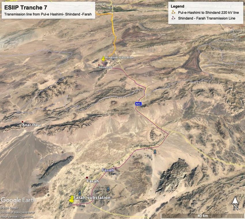
ABBREVIATIONS

ACCSAP   - Afghanistan’s Climate Change Strategy and Action Plan
ADB      - Asian Development Bank
AR4      - Fourth Assessment Report- IPCC (2007)
AR5      - Fifth Assessment Report- IPCC (2014)
AR6      - Sixth Assessment Report- IPCC (2021)
CCVI     - Climate Change Vulnerability Index
CMIP     - Coupled Model Intercomparison Project
CRVA     - Climate Risk and Vulnerability Assessment
DABS     - Da Afghanistan Breshna Sherkat
DRM      - Disaster Risk Management
DRR      - Disaster Risk Reduction
ESIIP    - Energy Supply Improvement Investment Program- Tranche 7
GCM      - General circulation models
GDP      - Gross Domestic Product
GFDRR    - Global Facility for Disaster Reduction and Recovery
GHG      - Greenhouse Gas
IPCC     - Intergovernmental Panel on Climate Change
NAPA     - National Adaptation Program of Action for Climate Change
NCCC     - National Climate Change Committee- Afghanistan
NEPA     - National Environment Protection Agency- Afghanistan
RCP      - Representative Concentration Pathways
SSP      - Shared Socioeconomic Pathways
UNFCCC   - United Nations Framework Convention on Climate Change
WB       - World Bank
WCRP     - World Climate Research Program
WG       - Working Group
WMO      - World Meteorological Organization

                                                                      i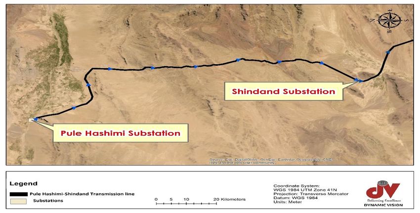
CONTENTS
ABBREVIATIONS I
CONTENTS II
LIST OF TABLES III
LIST OF FIGURES IV
EXECUTIVE SUMMARY VI
1 INTRODUCTION 1
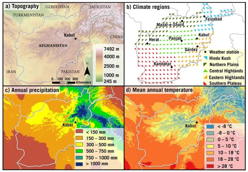
A. About this Report 1
B. About the concepts 2
C. Policies, Strategies, and Laws relevant to Climate Change 8
2 PROJECT DESCRIPTION AND ASSESSMENT METHODOLOGY 12
A. Project Profile 12
B. Country Profile 16
C. CRVA Methodology 19
3 CLIMATE CHANGE IMPACTS ON THE PROPOSED ESIIP 24
A. Observed Climate Variability and Change 24
B. Future Climate Change Projections 27
C. Natural Hazards in Afghanistan 4
4 CLIMATE RISK AND VULNERABILITY ASSESSMENT 11
A. Key Climate Impacts 11
B. Climate Impacts on Project Infrastructure 11
5 PROPOSED MANAGEMENT AND ADAPTATION ACTIONS 15
A. Options, Measures and Priorities for Climate Risk Mitigation and Adaptation
15
B. Climate Proofing Measures 16
C. Investing in Adaptation 16
6 STAKEHOLDER CONSULTATION AND GROUND VALIDATION 18
ANNEX 1. GLOSSARY OF TERMS 19
ii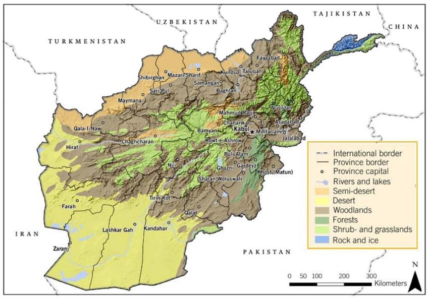
LIST OF TABLES

Table 2.1 - Risk Assessment Matrix .................................................................................... 21
Table 2.2 - Qualitative Measures of Likelihood .................................................................... 21
Table 2.3 - Qualitative Measures of Consequence .............................................................. 22
Table 3.1: Representative Concentration Pathways Scenarios ........................................... 28
Table 3.2 - Global Climate Change Predictions Under RCP8.5 (A High Emission Scenario)
and RCP2.6 (A Low Emission Scenario) for the Mid-21st Century (2046-2065). .................. 30
Table 3.3 - Projected trends for mean annual temperature, annual precipitation (Mar- Sep)
for two emission scenarios (RCP 4.5 and 8.5) and for the first half (2006-2050) and the
whole 21st century (2006-2099) as model mean and range for the whole country ................. 2
Table 3.4 - Earthquake Intensity Table .................................................................................. 6
Table 4.1 - Electricity Transmission System Vulnerability in Afghanistan ............................ 13
Table 5.1 - Potential Climate Risk Mitigation and Adaptation Measures .............................. 15
Table 5.2 - Indicative Cost of Climate Change Adaptation Measures .................................. 17

                                                                                                                         iii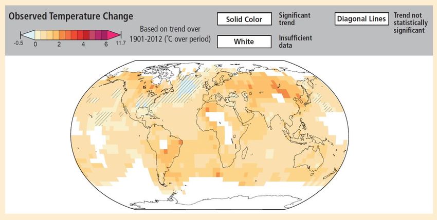
LIST OF FIGURES
Figure 1.1 - Comparison of Vulnerability (AR4) and Climate Risk (AR5) ............................... 3
Figure 1.2 - Atmospheric CO₂ Concentrations by SSP Across the 21st Century .................... 4
Figure 1.3 - SSPs Mapped in the Challenges to Mitigation/Adaptation Space ....................... 4
Figure 1.4 - Afghanistan’s CO2 Emissions by Sector ............................................................. 8
Figure 1.5 - Afghanistan’s CO2 Emissions by Year (tons) and Sector.................................... 8
Figure 2.1 - Provinces in the Project Area ........................................................................... 13
Figure 2.2 - The Alignment of the Transmission Line Through Six Districts in Heart and
Farah Provinces .................................................................................................................. 14
Figure 2.3 - Transmission Line Route from Pul-e Hashemi to Shindand Substation ............ 14
Figure 2.4 - Transmission Line Route from Shindand Substation to Farah Substation ........ 15
Figure 2.5 - Elevation Profile of the 220 kV Transmission Line from Pul-e Hashemi to
Shindand Substation (Google Earth Elevation profile) ......................................................... 15
Figure 2.6 - Elevation Profile of the 220 kV Transmission Line from Shindand Substation to
Farah Substation................................................................................................................. 16
Figure 2.7 - Physical Geography of Afghanistan, including Major Vegetation Zones and
Topography (Aich et al. 2017). ............................................................................................ 17
Figure 2.8 - Topography (a), Climatic Regions Used in the Analysis and Available Weather
Stations (b), Annual Precipitation for the Period 1960–1990 (c), and Mean Annual
Temperature for the Period 1960 -1990 (d) in Afghanistan (Aich et al. 2017). ..................... 18
Figure 2.9 - Verisk Maplecroft Global Climate Change Vulnerability Index 2016 ................. 19
Figure 3.1 - Observed Global Temperature Change (Based on Trends Over 1901-2012) ... 24
Figure 3.2 - The Spatial Distribution of Maximum Temperature in Afghanistan (Tmax; unit:
°C), (a) Summer and (b) Winter Seasons for the 1985-2015 Period. The Black Contour
Shows the Boundary of the Country .................................................................................... 25
Figure 3.3 - (a)The Spatial Distribution of Annual Total Rainfall (mm) in Afghanistan for the
1980-2015 Period. (b) the Annual Cycle of Rainfall in Afghanistan for the Same Period. ... 26
Figure 3.4 - Trends for temperature, annual precipitation, spring precipitation (March- May),
Winter precipitation (November- January), and heavy precipitation (95th percentile) for
Afghanistan from 1951- to 2010. (Derived from reanalysis data (GSWP3)). ........................ 26
Figure 3.5 - Change in temperature between 1951-1980 and 1981-2010 in Afghanistan from
reanalysis of data (GSWP3) ................................................................................................ 27
Figure 3.6 - Change in annual precipitation between 1951- 1980 and 1981 to 2010 in
Afghanistan derived from reanalysis data (GSWP3)............................................................ 27
Figure 3.7 - Global Temperature Projections for RCP8.5 and RCP2.6, 1950 - 2100 ........... 29
Figure 3.8 - Projected Temperature Change for RCP8.5 (High Emission) and RCP2.6 (Low
Emission) Scenarios for 2081 to 2100 ................................................................................. 29
Figure 3.9 - Mean annual temperature for Afghanistan for seven regional climate models for
a base period (grey 1970-2005) and a scenario period (2006-2100) with limited GHG
emissions (green, RCP 4.5) and uncontrolled GHG emissions (red, RCP 8.5). ..................... 2
Figure 3.10 - Projected changes in temperature in oC for Afghanistan as mean of seven
regional climate models between a scenario period (2021-2050) and base period (1976-
2005) under limited GHG emissions (left RCP 4.5) and uncontrolled GHG emissions (right,
RCP 8.5) ............................................................................................................................... 3
Figure 3.11 - Annual precipitation for Afghanistan for seven regional climate models for a
base period (grey, 1970-2005) and a scenario period (2006-2100) with limited GHG
emissions (green, RCP 4.5) and uncontrolled GHG emissions (red, RCP 8.5). ..................... 3
Figure 3.12 - Projected changes of annual precipitation in % for Afghanistan as mean of
seven regional climate models between a scenario period (2021-2050) and a base period
(1976-2005) under limited GHG emissions (left RCP 4.5) and uncontrolled GHG emission
(right, RCP 8.5) ..................................................................................................................... 4
Figure 3.13 - Map of the provinces of Afghanistan (as of 2010) with the highest hazard
vulnerability ........................................................................................................................... 5
Figure 3.14 - Earthquake Intensity of the Project Area .......................................................... 6
Figure 3.15 - Pathway of sand storm via Afghanistan (19th March 2012) ............................... 8

                                                                                                                                        iv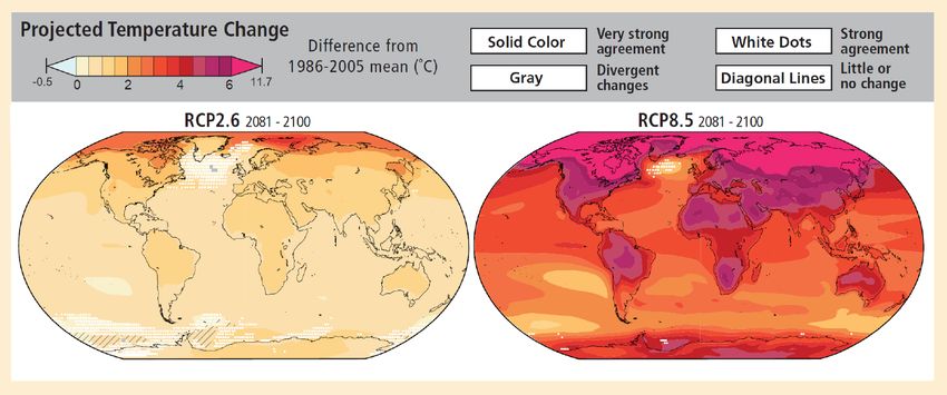
Figure 3.16 - Natural disasters (Flood/ Flash Floods and heavy snowfalls) occurred in the
Western part of Afghanistan (Heart and Farah provinces) in 2020 ........................................ 9
Figure 3.17 - Monthly trends of natural disasters (avalanche, heavy snowfall, landslide/
mudflow and flood/flash flood) occurred in Heart and Farah provinces from 2012 to 2020.
Earthquakes were not recorded during this period. ............................................................... 9

                                                                                                                 v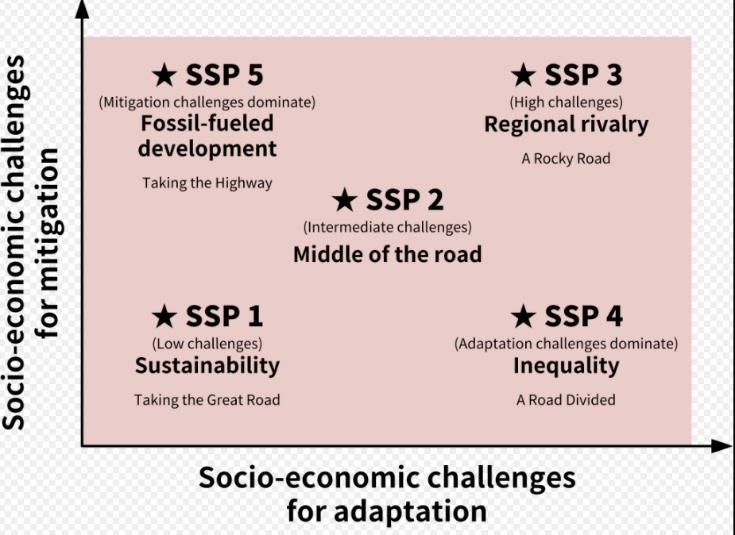
EXECUTIVE SUMMARY

1.      The proposed project comprises a 220 kV, 135 km double circuit transmission line from
existing 220/20 kV Pul-e-Hashemi substation to the Shindand 220/20 kV substation; 220 kV,
176 km double circuit transmission line from 220/20 kV Shindand substation to 220/20kV
Farah substation; construction of 220/20kV Shindand substation and expansion of 220/20kV
Pul-e-Hashemi substation in the Herat province; and the construction of 220/20 kV Farah
substation. The project will also, design and construct the distribution network in the Shindand
and the Farah areas.

2.      The geographical characteristics and arid climate make Afghanistan and its
infrastructure prone to a wide range of natural hazards—floods, droughts, landslides, heavy
snow falls/ avalanches, sandstorms and earthquakes. Between 1980 and 2016, disasters
triggered by natural hazards have caused more than 21,000 deaths, affected the lives and
livelihoods of almost 9 million people, and resulted to approximately $525 million in direct
physical losses. With climate change, it is expected that the mean annual temperature will
increase, spring precipitation will decrease, and the intensity and frequency of extreme
weather events may change. This will further impact the lives, livelihoods, and assets of the
Afghan population.

3.       The proposed project lies in Heart and Farah provinces in the western part of
Afghanistan. Both provinces are at risk from flood/ flashflood, landslides/ mudflow, heavy
snowfall, avalanches and sandstorms. Results of the preliminary climate risk screening and
the climate and geophysical hazard screening indicate that the proposed project is at medium
risk to climate change and has low risks from geophysical hazards. Climate and disaster risk
assessment for the project provinces are not currently available.

4.     Flooding is the most frequent natural hazard with 21 out of 34 provinces in Afghanistan
being vulnerable to floods. Landslides triggered by heavy rainfall and seismic activity are
common in Afghanistan due to rugged mountainous terrain, unstable soil, change in land
cover, and farming and irrigation practices. Areas prone to avalanches can be found in the
mountain ranges in the northeast and western regions of Afghanistan. Droughts of varying
length and severity regularly affect the livelihoods and incomes of millions of Afghan people.
The interaction of above-mentioned natural hazards with low levels of socioeconomic
development and decades of conflict contributes to high levels of disaster risk in Afghanistan.

5.      The Government of Afghanistan recognizes the importance of strengthening climate
and disaster resilience for achieving sustainable development in the country and is attaching
increased priority to disaster risk reduction and climate change adaptation. Afghanistan is a
signatory to the key international agreements, including the Sendai Framework for Disaster
Risk Reduction and the Paris Agreement on climate change. It has developed the Nationally
Determined Contribution, which details the key priorities for climate change adaptation
including, among others, reducing the vulnerability of the country and its population through
enhancement of adaptive capacity and resilience, and deployment of disaster risk reduction
measures.

6.     Various decisions can be implemented for Energy Supply Improvement Investment
Program Tranche 7, (ESIIP) to reduce impacts on climate change, improve its resilience to
climate change hazard risks and assist Afghanistan to meet its climate change adaptation
actions. Several technological improvements are available for transmission line and substation
designs which can bring efficiency improvements. Therefore, flexible but robust designs,
together with adaptive management practices will be critical in managing climate risks and
adaptation for the ESIIP. A range of potential climate adaptation measures that may be

                                                                                              vi
employed to improve the climate resiliency of the project is proposed and their indicative costs
are presented.

                                                                                             vii
1   INTRODUCTION

A.      About this Report

1.      Overview

1.      The Climate Risk and Vulnerability Assessment (CRVA) helps to identify the nature
and extent to which climate change and its impacts may adversely affect a country, region,
sector or community. Therefore, CRVA is a central component of adaptation action to design
the adaptation policies and projects, and to establish a baseline against which the success of
adaptation policies can be monitored. The Asia and Pacific region are vulnerable to
temperature extremes, and flooding by heavy rainfall, sea level rise and tropical cyclones
(ADB, 2017). Risks from climate change are further amplified by the pace of population growth
and rapid development of urban areas. Both trends are concentrating people and assets in
places that are potentially exposed to climate threats. Climate change also has implications
for food, water and energy security, mitigation and the stability of trade networks in the region.
Therefore, the ADB has made a commitment to provide $ 6 billion of climate financing per year
by 2020, of which $2 billion will be allocated for adaptation, to counter the risks from climate
change1.

2.      ADB has introduced mandatory screening of infrastructure projects to identify those at
high or medium risk of being adversely affected by climate change. These projects must be
‘climate- proofed’ to make them resilient to identified climate change impacts. Due diligence
requires that adaptation finance is invested in projects that deliver intended benefits at the
least cost1.

3.      The climate or disaster risk is a function of hazard, exposure, and vulnerability. The
hazard component refers to the probability of occurrence of a hazard event of varying intensity
for a defined geographical area. Exposure quantifies the assets or elements in that area and
their replacement value. Vulnerability captures the degree of damage to specific assets or
types of asset as a consequence of a hazard event of varying intensity. Climate risk
assessment combines the three components together, determining the relationship between
hazard, exposure, and vulnerability. CRVA can be undertaken using quantitative or qualitative
methodologies and the implied disaster risk.

4.      A hazard is a “process, phenomenon or human activity that may cause loss of life,
injury or other health impacts, property damage, social and economic disruption or
environmental degradation”2. Natural hazard assessment is the first step in the risk
assessment process. Hazard analysis focuses on three main characteristics: intensity,
frequency, and size or location of the natural hazard. Identifying elements exposed to natural
hazards is the second step of the risk assessment. Exposure concern ‘the presence of people,
livelihoods, environmental services and resources, infrastructure or economic, social or
cultural assets in places that could be adversely affected3.

5.     Third step is the vulnerability analysis. Vulnerability assessments are performed on
those elements that are determined to exhibit a certain degree of exposure to a natural hazard.
The concept of vulnerability covers a range of physical, social, economic, and environmental
features. It describes “the conditions determined by physical, social, economic and
environmental factors or processes which increase the susceptibility of an individual, a
community, assets or systems to the impacts of hazards” (UNISDR 2017). The risk

1 Information Sources to Support ADB Climate Risk Assessment and Management, Technical Note, September
2018
2 United Nations Office for Disaster Risk Reduction (UNISDR, 2017)
3 Special Report of the Intergovernmental Panel on Climate Change (IPCC, 2012)

                                                                                                    1
assessment, the final step, is a qualitative or quantitative approach to determine the nature
and extent of disaster risk by analyzing potential hazards and evaluating existing conditions
of exposure and vulnerability that together could affect people, property, services, livelihoods
and the environment on which they depend.
6. The proposed project comprises a 220 kV, 135 km double circuit transmission line from
the existing 220/20 kV Pul-e-Hashemi substation to the proposed Shindand 220/20 kV
substation; a 220 kV, 177 km double circuit transmission line from the proposed 220/20 kV
Shindand substation to the proposed 220/20kV Farah substation; construction of the 220/20kV
Shindand substation and expansion of the 220/20kV Pul-e-Hashemi substation in the Herat
province; and construction of the 220/20 kV Farah substation. Also, the project will design and
construct the distribution networks in the Shindand and the Farah areas.
7. This climate risk and vulnerability assessment (CRVA) is submitted to ADB by the Da
Afghanistan Breshna Sherkat (DABS) Project Management Unit and the final CRVA report will
be disclosed to the public through the ADB website.
2. Scope of the Assessment
8. The objectives and scope of this CRVA are to (i) review the international and national
climate change modeling and emissions scenarios; (ii) assess the existing climate conditions
in Afghanistan; (iii) identify potential impacts from climate changes in Afghanistan to the
Energy Supply Improvement Investment Program (ESIIP-Tranche 7); (iv) determine and
evaluate importance of these impacts; and (v) develop mitigation measures; monitoring
activities, reporting requirements to ensure that such concerns are addressed in the project
design and mitigation procedures.
9. The following chapters of the CRVA examine the expected climate change hazards,
risks, and impacts of ESIIP and outline possibilities to mitigate the future climate change risks.
• Chapter II – Project description and assessment methodology
• Chapter III – Climate change impacts on the proposed ESIIP
• Chapter IV – Climate risk and vulnerability assessment
• Chapter V – Proposed management and adaptation actions
• Chapter VI – Stakeholder consultation and ground validation
B. About the Concepts
1. Risk and Vulnerability
10. In the Fourth Assessment Report of the IPCC (AR4) 2007,4 vulnerability is a core
concept that describes the propensity or predisposition to be adversely affected. Vulnerability
encompasses a variety of concepts including sensitivity or susceptibility to harm and lack of
capacity to cope and adapt.
11. In the latest Fifth Assessment Report (AR5) of the IPCC Working Group II (WGII)
2014,5 the concept of vulnerability has been replaced by the concept of risk of climate change
impacts. The potential for consequences where something of value is at stake and where the
outcome is uncertain, recognizing the diversity of values. Risk is often represented as the
probability of occurrence of hazardous events or trends multiplied by the impacts if these
events or trends occur. Risk results from the interaction of vulnerability, exposure, and hazard.
In this report, the term risk is used primarily to refer to the risks of climate-change impacts that
4IPCC. 2007. Fourth Assessment Report (AR4) of the United Nations Intergovernmental Panel on Climate Change.
5IPCC. 2014. Summary for Policymakers. In: Climate Change 2014: Impacts, Adaptation, and Vulnerability. WGII
Contribution to the 5th Assessment Report of the Intergovernmental Panel on Climate Change.
2may harm a system. The vulnerability of a system is now only one component of the risk that
may increase or decrease the potential consequences of a hazard (
12. Figure 1.1).
Figure 1.1 - Comparison of Vulnerability (AR4) and Climate Risk (AR5)
13. The climate change projections made by the IPCC AR4 for the South and Central Asia,
states that the rainfall in summer season is expected to be increased where severe rainfall
with winds will rise up to cyclones and thunderstorms. The changes in the climate is predicted
to affect the main system which shape the South and Central Asian region’s climate including
the strength and the timing of Asian monsoon rains. The receding Himalayan glaciers are
considered to be another major reason which helps to speed up the rapid climate changing
process. The rising temperature in South and Central Asian countries also increases some
economic burdens, ranging from health risks to electricity bills6. Understanding the specific
vulnerabilities and risks when planning and implementing projects is crucial since it can
prioritize resources. This can help to identify which regions, sectors or system components
are especially affected by the climate change and the critical places where the adjustments
should be carried out effectively to prevent the risks.
2. Shared Socioeconomic Pathways (SSPs) and AR6
14. Shared Socioeconomic Pathways (SSPs) are scenarios of
projected socioeconomic global changes up to 2100. They are used to derive greenhouse gas
emissions scenarios for Sixth Assessment (AR6) with different climate policies, (UNECE, 15
May 2019). The scenarios are:
• SSP1: Sustainability (Taking the Green Road)
• SSP2: Middle of the Road
• SSP3: Regional Rivalry (A Rocky Road)
• SSP4: Inequality (A Road divided)
• SSP5: Fossil-fueled Development (Taking the Highway)
15. The IPCC AR6 Report on global warming is due in 2021. The SSPs provide narratives
describing alternative socio-economic developments. These storylines are a qualitative
6“Assessing the Costs of Climate Change and Adaptation in South Asia”, M Ahmed and S Suphachalasai, June
2014
3description of logic relating elements of the narratives to each other. In terms of quantitative
elements, they provide data accompanying the scenarios on national population, urbanization,
and GDP (per capita). The SSPs can be combined with various Integrated Assessment
Models (IAMs), to explore possible future pathways both with regards to socioeconomic and
climate pathways, (SSP Database, Version 2, December 2018).
16. Figure 1.2 shows the different atmospheric CO2 concentration levels across the 21st
Century for different SSPs projected by MAGICC6, a simple/reduced complexity climate
model. Each dotted point represents an average of simulated values generated from 6 climate
models (AIM/CGE, GCAM4, IMAGE, MESSAGE-GLOBIOM, REMIND-MAGPIE, & WITCH-
GLOBIOM - SSP Database - Version 2.0).
Figure 1.2 - Atmospheric CO₂ Concentrations by SSP Across the 21st Century
Figure 1.3 - SSPs Mapped in the Challenges to Mitigation/Adaptation Space
17. The World Climate Research Programme’s (WCRP) Working Group on Coupled
Modelling (WGCM) oversees the Coupled Model Intercomparison Project (CMIP), which is
now in its 6th phase. Background information about CMIP6 and its phases can be found
on Working Group of Coupled Modelling (WGCM) website as well as on the Programme for
4Climate Model Diagnosis and Intercomparison (PCMDI) hosted pages. An introductory
overview of CMIP6 is also provided by the WGCM.
18. South Asian countries face many interconnected climate risks such as frequent floods
as well as droughts in seasons throughout the year. The latest coupled model intercomparison
project phase 6 (CMIP6) dataset was analyzed by Almazroui et al. (2020) to examine the
projected changes in temperature and precipitation over South Asia during the twenty- first
century.
19. With a population more than 1.8 billion, South Asia region is a global hotspot for the
insecurity of food (agricultural products), where climate change will affect severely. The
economy of South Asian countries depends largely on monsoonal rains and winter
temperature where almost 80% of the water comes from the summer monsoon. In most of the
South Asian region, it is predicted that the annual mean precipitation will be increased. In the
near future, the annual mean temperature in the region is expected to increase around 10%
to 20% with respect to the present climate change. The multimodel ensemble from 27 CMIP6
models projects a continuous increase in the annual mean temperature over South Asia during
the twenty-first century under three future scenarios. The projected temperature shows a large
increase (over 6 °C under SSP5-8.5 scenario) over the northwestern parts of South Asia,
comprising the complex Karakorum and Himalayan mountain ranges. Any large increase in
the mean temperature over this region will most likely result in a faster rate of glacier melting.
20. The warming over South Asia is also continuous on the seasonal time scale. The
CMIP6 models projected higher warming in the winter season than in the summer over South
Asia, which if verified will have repercussions for snow/ice accumulations as well as winter
cropping patterns. The annual mean precipitation is also projected to increase over South Asia
during the twenty-first century under all scenarios. The rate of change in the projected annual
mean precipitation varies considerably between the South Asian countries.
21. In the imminent future, the annual mean temperature averaged over South Asian
region is estimated to be increased by 0.9 °C to 1.2 °C covering the Karakorum and Himalayan
Mountain ranges7. A huge rise in the mean temperature over this region might result in a faster
rate of glacier melting as well. The expected temperature changes are largest over the North–
Western part of the South Asian domain covering mostly India, Pakistan and Afghanistan.
22. Climate change which is the ultimate outcome of global warming is now recognized as
the fundamental human development challenge of the 21st century. IPCC has conclusively
established that Climate change induced by global warming is the direct result of excessive
emissions of greenhouse gasses due to human action, particularly due to uncontrolled
combustion of fossil fuels. It is a certainty that the present and future generations have to live
under the threat of climate change. All nations are affected by the impacts of climate change.
However, developing countries are particularly vulnerable, as they lack the necessary
adaptive capacity.
3. Climate Risk and Vulnerability in Energy Sector
23. Globally, the electric utility sector emited 35% of total global emissions in 2010 (IPCC,
2014). The industry also faces considerable vulnerability to climate change impacts due to
capital-intensive infrastructure investments associated with resource extraction, power
generation, and distribution and transmission, as well as market pressures linked to
7Almazroui et. al. (2020) Projections of Precipitation and Temperature Over the South Asian Countries in Cmip6.
Earth System and Environment.
5demographic transitions and a changing climate. The annual cost of electricity production is
projected to increase by 14% or $51 billion by 2050 due to warming temperatures. Damage
to energy infrastructure can have a considerable impact on social systems, economies, and
ecological systems.
24. Climate risk management can be seen as a process that incorporates knowledge and
information about climate-related events, trends, forecasts and projections into decision
making to increase or maintain benefits and reduce potential harm or losses. The climate risk
management in the electric utility industry is critical for several reasons. The electric utilities
are a public good that provide a fundamental societal, cultural, and economic service.
Improved climate risk management means utilities are better prepared against climate change
related to disruptions of electricity service. Electric utilities have a unique financial
interdependency with the populations they serve. A major climate change impact could result
in rate increases that would add financial stress to customers, in addition to incurred losses to
the utility. Also, the electric utility industry has complex infrastructure exposed to a wide range
of threats that, in some geographic regions, are at extreme risk to climate change impacts.
25. There is significant emphasis on the identification of potential climate change impacts
and opportunities for adaptation in climate risk management in the electric utility industry. It is
noted that less attention has been paid to assessment of risk, stakeholder engagement, and
cross-sectoral collaboration in climate risk management.8
4. Climate Risk and Vulnerability of the country
26. Afghanistan is particularly vulnerable to the impacts of climate change due to a
combination of geographic, climate, socio-economic and security related factors. The majority
of the population is poor and 79% of the Afghan population depends on agriculture and
livestock for their livelihoods and are thus dependent on the country’s natural resource base.
Their food security and incomes are directly influenced by the weather. The climate in the
country is generally arid and thus, agriculture is already prone to the impacts of drought.
Besides, large parts of the country are mountainous, which on one hand means that many
farmers benefit from irrigation fed by rivers getting their water from glaciers and spring snow-
melt in the high altitudes, but on the other, they are vulnerable to floods. The impacts of climate
change are already felt, with an increase in both frequency and intensity of droughts as well
as floods as a result of increased glacier melting. It is predicted that extreme weather events
and drought will further increase as a result of global warming – changes which are likely to
have an adverse effect on both natural ecosystems and agricultural systems, thereby
threatening the livelihoods and food security of the rural population9.
27. Afghanistan is ranked among the most vulnerable countries in the world to the adverse
impacts of climate change.10 Afghanistan’s INDC report has documented an increase of 0.6°C
in the country’s mean annual temperature since 1960. Based upon recent climate
observations, precipitation patterns have decreased during springtime (March-May) by
approximately 40.5mm; however, the total annual precipitation has only slightly decreased by
approximately 30mm since there is a slight increase in precipitation from June until November.
This implies that Afghanistan is already beginning to experience the initial adverse impacts of
climate change.
8 “Climate Risk Management (2017)”, A K Gerlak, J Westom, B McMahan, R L Murray, M Millis-Novoa, Climate
risk management and electricity sector, 2017
9 Building Adaptive Capacity and Resilience to Climate Change in Afghanistan (LDCF-1 project, 2013-2017)
10 German Watch Global Climate Risk Index (2013)
628. Recent climate projections, based on Cordex regional climate models and
representative concentration pathways (RCPs)11, indicate that Afghanistan will face an overall
strong increase in mean annual temperature, considerably higher than global mean
projections, when compared to a baseline period of 1986-2006. More specifically, under the
“optimistic” scenario (RCP4.5), the mean of the model ensembles projects a warming of
approximately 1.5°C until 2050 and of approximately 2.5°C until 2100. For the “pessimistic”
scenario (RCP8.5), the models project an extreme warming of approximately 3°C until 2050,
with further warming up to 7°C by 2100. Under both scenarios there are regional differences,
with a higher temperature increases at higher altitudes compared to the lowlands.
29. For precipitation a significant (α=0.05) mean decrease of precipitation during
springtime (March-May) for the North, the Central Highlands and the East for both scenarios
from 2006 until 2050 between 5-10 % is seen. This decrease is offset by a slight increase of
precipitation during autumn and wintertime (October-December) in these regions. For the
Hindu Kush area, a significant and substantial increase in precipitation during the winter
season of approximately 10 % is seen, whereas during spring season precipitation is projected
to stay stable. For the arid South of the country, the models do not project significant trends
for precipitation. The decrease of precipitation during spring is particularly relevant since
during these months the main plant growth for agricultural production takes place.
30. In addition, the decrease is projected to take place in the regions with the highest
agricultural productivity of Afghanistan (East, North, and Central Highlands). In combination
with the overall increase in temperature and the related increase in evapotranspiration across
the country, this will most likely negatively impact the hydrological cycle, agricultural
productivity, and availability of water resources. Climatic changes are also likely to impact
upon the spread of water, food and vector-borne diseases, presenting considerable health
risks to both urban and rural populations. Finally, the aforementioned climate-induced risks
and challenges can enhance social inequalities, poverty, and food insecurity causing
considerable and fundamental threats to human life, livelihoods, property, political stability,
the economy, and the environment in Afghanistan.
31. Based upon these climate change projections, Afghanistan’s environment will
experience considerable changes over the remainder of this century. Climate change, based
on sound scientific analysis of climatic changes and uncertainties, must be mainstreamed into
sectoral planning to reduce the negative impacts of climate change in Afghanistan and
increase resilience, both in rural and urban areas.
5. CO2 Emissions
32. Fossil CO2 emissions in Afghanistan were 9.9 million tons in 2016, increased by 7.13%
compared to the emissions in 2015. It is a share of 0.03% of World’s CO2 emissions in 2016.
Co2 emissions per capita in Afghanistan are equivalent to 0.28 tons per person (based on
population 35.4 million in 2016), an increase by 0.01 over the figure of 0.27 CO2 tons per
person in 2015. Figure 1.4 and Figure 1.5 show CO2 emissions by sector and the year12.
11 Representative concentration pathways (RCPs) are GHG emission scenarios adopted by the IPCC to describe
four possible climate futures depending on the levels of future global GHGs emitted. There are four RCPs: 1)
RCP2.6, which assumes that GHG emissions peak between 2010-2020 and then decline; 2) RCP4.5, which
assumes that GHG emissions peak around 2040 and then decline; 3) RCP6, which assumes that GHG emissions
peak around 2080 and then decline; and 4) RCP8.5, which assumes that GHGs emissions continue to rise
throughout the 21st century.
12 https://www.worldometers.info/co2-emissions/afghanistan-co2-emissions/
7Figure 1.4 - Afghanistan’s CO2 Emissions by Sector
Figure 1.5 - Afghanistan’s CO2 Emissions by Year (tons) and Sector
C. Policies, Strategies, and Laws relevant to Climate Change
1. Energy sector and climate change
33. Afghanistan’s energy sector has been particularly hard hit by decades of conflict and
neglect. Currently, domestic energy production is at nearly the same level as it was just prior
to the invasion of the Soviet Union in 1978, to say nothing of the condition of those energy
8producing facilities13 Afghanistan’s abundant water resources mean that the country has
considerable potential for hydropower development, which at present accounts for
approximately 50 percent of domestic electricity installed capacity, with the remainder made
up by thermoelectric and diesel generators14. Afghanistan also relies heavily on electricity
imports from neighboring countries which account for more than three quarters of
Afghanistan’s total electricity usage. In order to reduce reliance on imported electricity the
Government has made it a national priority to promote domestic energy production, and quite
reasonably Afghanistan’s Energy Sector Strategy emphasizes the strong potential of domestic
hydropower development in order to meet the country’s energy needs and promote economic
growth.
34. However, the uncertain impacts of climate change on the availability of water resources
and increased risk of natural disasters, such as floods, raises questions about the safety and
sustainability of hydropower dams. In addition, Afghanistan has considerable potential for
renewable energies including solar, wind, and biomass, particularly if implemented in a
decentralized manner for rural areas that do not have access to power grids. This has clear
benefits for climate change mitigation and climate change adaptation, as well as sustainable
development and poverty alleviation.
35. The Energy Sector Strategy does not make any reference to climate change either as
a risk to energy production or in the context of adaptation techniques and approaches to build
the resilience of the energy sector. However, in reference to renewable energies it mentions
the environmental benefit of reducing carbon emissions, which are the cornerstone of climate
change mitigation. Since the Energy Sector Strategy emphasizes the country’s strong
hydroelectric power potential, it should consider the impacts of climate change, particularly as
the National Adaptation Programme of Action for Climate Change (NAPA) identifies the energy
sector as one of the most vulnerable areas for the country. It should therefore mainstream
climate considerations into all future energy development plans that rely on water resources.
This should also be coupled with the further promotion of decentralized renewable energy
options for rural communities, especially solar and biomass, in order to build the resilience
and adaptive capacity of the country’s population.
36. As part of its national commitments to the UNFCCC and in order to strengthen climate
protection measures, NEPA has prepared two national communications on climate change
(2012, 2017). Despite the country’s many competing development needs, Afghanistan has
made steady progress towards mainstreaming climate change into national planning
mechanisms and approaches. Afghanistan’s premiere inter-ministerial coordination body for
climate change is the National Climate Change Committee (NCCC). In addition, a number of
other national-level, inter-ministerial forums provide valuable entry points for addressing
climate change in the areas of agriculture, biodiversity, forests and rangelands, energy,
disaster preparedness, and water. In each of these areas, Afghanistan has developed and
adopted a wide range of laws, policies, strategies, and plans that are relevant to climate
change. Mainstreaming climate change into these areas and across a greater breadth of
national planning structures will also be achieved through the thorough adoption and
application of Afghanistan’s Climate Change Strategy and Action Plan (ACCSAP).
13 USAID, Afghanistan Energy Sector Overview, available (September 2015) at: http://www.sari-
energy.org/PageFiles/Countries/Afghanistan_Energy_ detail.asp
14 DABS (2013), Energy Sector Overview. Kabul: Da Afghanistan Breshna Sherkat. Available at:
http://eneken.ieej.or.jp/data/5015.pdf
9The National Environment Strategy (NES)
37. The National Environmental Strategy was developed in 2007 through the Afghanistan
National Development Strategy as a reflection of the environment as a crosscutting theme
across all of Afghanistan’s development priorities. The NES focuses on the two priority
objectives of environmental governance and environmental management, and lays out
thematic strategies for the following six areas: i) forestry and rangelands; ii) protected areas
and biodiversity; iii) water and wetlands; iv) air quality; v) urban and industrial environmental
management; and vi) environmental education and awareness. Although the NES does not
make any mention of climate change, its overall focus is on the mainstreaming of
environmental issues into national development priorities and plans in order to strengthen the
management and governance of the country’s environment and natural resources. Thus, the
NES provides a valuable framework for the mainstreaming of climate change into national
development priorities and plans, particularly through concrete recommendations for
institutional strengthening and capacity building, as well as targeted thematic strategies that
bring together the full spectrum of government institutions and stakeholders for the country’s
major environmental sectors.
The National Environmental Action Plan (NEAP)
38. NEAP was drafted by the National Environmental Protection Agency (NEPA) in 2009,
as per the legal requirement of Article 9 of the Environment Law, and builds off the NES to
identify specific actions to protect and address the country’s environmental challenges. The
NEAP focuses specifically on air, water, land, and biodiversity, but also strongly emphasizes
the need for environmental considerations to be mainstreamed into national policies in order
to maximize environmental opportunities and minimize negative environmental impacts.
Climate change is mentioned several times in the NEAP, particularly as a serious risk to
biodiversity and the water sector, as well as the specific action to “undertake a study to
determine the likely impacts of climate change on the agricultural and natural resource base
of Afghanistan” framed within the discussion on the forestry and rangeland sector.15
Afghanistan’s Environment Law (AEL)
39. Afghanistan’s environment law came into force in 2005 and was passed by the
National Assembly in 2007, replacing the earlier Nature Protection Act of 1986/2000. The
Environment Law does not explicitly mention climate change, but does cover areas of the
environment that are impacted by and relevant to climate change, such as integrated pollution
control, water resource conservation and management, biodiversity and natural resource
conservation and management.16
40. The Environment Law establishes a regulatory framework for the sustainable use and
management of Afghanistan’s natural resources base, and provides for the conservation and
rehabilitation of the environment towards achieving the country’s social, economic,
reconstruction, and ecological development goals. The National Environmental Action plan
(NEPA) led the development of the Environment Law and its processing through the relevant
legislative sections within the Government for approval and ratification, while UNEP provided
technical assistance and facilitated public consultations with national and international
stakeholders.
15Afghanistan (2010). National Environmental Action Plan. Kabul: National Environmental Protection Agency,
p.23.
16 Afghanistan (2007a), Environment Law
1041. The Environment Law also defines a list of fundamental principles and the rights and
duties of the state and persons, as well as clear definitions of the functions and powers of
NEPA and several inter-ministerial environmental coordination mechanisms. In addition, in the
absence of legislation on climate change, it is worth noting that Article 75 of the Environment
Law states that “relevant line ministries and institutions, in cooperation with NEPA, shall take
appropriate measures for the management of environmental issues in relevant sub-sectors,
including forestry, rangelands, biodiversity, protected areas, national parks, public health and
other sectors in accordance with relevant laws and regulations.
Afghanistan’s National Biodiversity Strategy and Action Plan (NBSAP)
42. NBSAP was developed in 2013 by NEPA with the goal of conserving all aspects of the
country’s biodiversity and ensuring that future utilization of biodiversity resources is
sustainable.17 The NBSAP also identifies the short-, medium-, and long-term actions and
biodiversity goals for Afghanistan to successfully implement the UNCDB. Within these actions
and goals, the NBSAP identifies climate change as a serious risk to biological diversity in
Afghanistan, particularly as a result of drought and desertification, but also notes “climate
change has not been a consideration in the national or sectoral plans of the Government.” In
2015, NEPA began the process of revising and updating Afghanistan’s NBSAP, which
includes alignment with the 2020 Aichi Biodiversity Targets. Through this process there is a
clear opportunity for the linkages between biodiversity and climate change to be articulated in
an official government document, which would raise the profile of both biodiversity and climate
change within national and sectoral development plans, as well as generate further
momentum for ecosystem-based adaptation as an approach to reduce the impacts of climate
change.
17Afghanistan. (2014). National Biodiversity Strategy and Action Plan. Kabul: National Environmental Protection
Agency
112 PROJECT DESCRIPTION AND ASSESSMENT METHODOLOGY
A. Project Profile
43. The project will comprise of two components. Component 1: will include: (i) the 220kV
double circuit transmission line from 220/20kV Pul-e-Hashemi substation in the Herat province
to Shindand 220/20 kV proposed substation with a line length of 135 km; (ii) the 220kV double
circuit transmission line from the proposed 220/20kVShindand substation in the Herat
province to the proposed 220/20kV Farah substation with a line length of 176 km; (iii)
construction of the 220/20kV Shindand substation and expansion of 220/20kV Pul-e-Hashemi
substation in the Herat province; and (iv) construction of the 220/20kV Farah substation in the
Farah province.
44. Component 2 will include: (i) the design and construction of the distribution network
in the Shindand area to provide 7,000 household connections; and (ii) the design and
construction of the distribution network in the Farah area to provide 20,000 household
connection. The total number of beneficiaries from the Project, as estimated by DABS, will be
about 190,000 people.
45. The transmission line starts at Pul-e-Hashemi substation in Herat and travels
southward by crossing several flood ways. The line follows a parallel path with Iran 132 kV TL
and TAPI corridor (between the two). Ghuchinak, Karez-e-Sofi, Tizon and Hasan Abad villages
are crossed one by one until the line reaches the end of Hasan Abad village where it turns
towards east and continues along with the hill ridges towards Gozareh District and Herat
airport. Several flood ways are encountered in this area as well; however, construction of the
line is feasible in this part of the route. Near Gozareh District the line leaves Iran 132 kV line
and turns towards south once again to align itself with Herat – Kandahar highway. The line
continues its journey along the highway and in 2 km from Mirdawood area it will have a cross-
over with TABI corridor. Here are the TL highlights:
46. The line traverses several hilly and semi-mountainous areas along its route at the west
side of the TAPI corridor crossing flood ways and having larger than 15° angles in some
places. The line reaches Adraskan District by crossing rocky terrains with changing elevation
and directions while following the highway at the west side of TAPI corridor. The line follows
its journey to the south until it reaches the valley of Ziarat-e-Khaja Owrya just before reaching
the Shindand Desert. At this point after travelling for a distance of 113 km, the line separates
itself from Herat – Kandahar highway and follows Shindand district road at the west side of
Shindand airport. The line traverses some agricultural lands and private owned plain lands as
it crosses over the highly cultivated areas named above. There are many floodways along the
route which needs special considerations during construction works. The first segment of the
line is completed after travelling 135 km from Pul-e-Hashemi substation in Herat and reaching
Shindand substation at 33°21'36.08"N 62° 9'38.56"E. The line route has been selected to keep
maximum distance with the road, TAPI corridor and the residential areas to possible extents.
The investigation area of the distribution line covers the distribution network corridor and its
perimeter of influence in the particular locations of the two provinces. The line enters the
substation switchyard in the north side.
47. The second segment of the line which connects Shindand substation to Farah
substation starts from Shindand and the length of the transmission line is 176 km. The line
crosses Shurab area at the south side of the substation and moves towards south-east along
the mountain skirts until it reaches the Kavajeh Nuh area where it reaches open bare lands.
This continues towards Samalan area followed by Borj. In this part of the route several
seasonal river streams need to be crossed before the line finally reaches the inhabited Syasar
desert where it follows a parallel path to an existing floodway towards Herat – Kandahar
highway. The line stays at the west side of the highway to keep its clearance from the highway
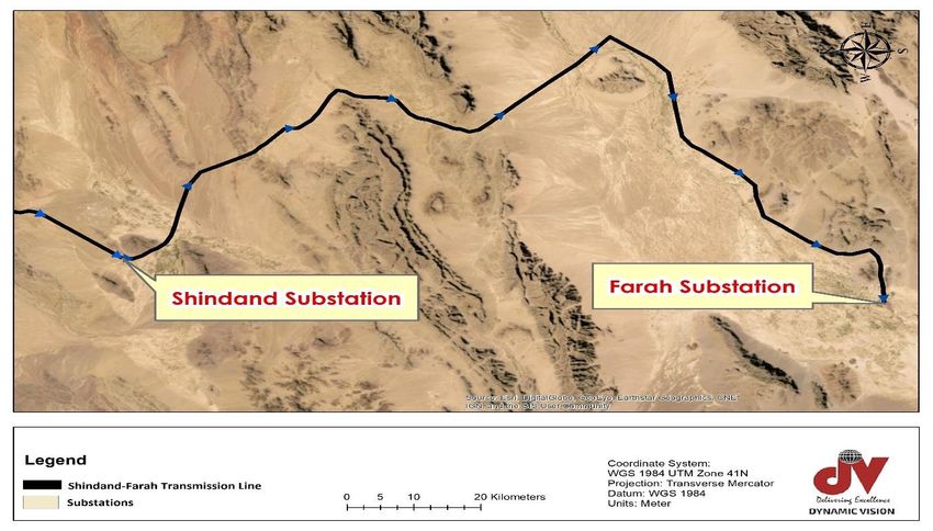
12and the TAPI corridor again. Here are the major highlights of the line route: The line follows
the highway and reaches Shawz hills and then enters a mountainous region and traverses the
rocky terrains for a 3 km distance before it hits Shawz Desert. The route from this point until
the Farah Rud area where the line turns towards Farah city at the west is mainly bared desert
lands with some seasonal floodways separated by intermittent mountainous rocky terrains.
The line crosses a large floodway in Cahcahan area in Shawz Desert.
Figure 2.1 - Provinces in the Project Area
13Figure 2.2 - The Alignment of the Transmission Line Through Six Districts in Heart
and Farah Provinces
Figure 2.3 - Transmission Line Route from Pul-e Hashemi to Shindand Substation
14Figure 2.4 - Transmission Line Route from Shindand Substation to Farah Substation
Figure 2.5 - Elevation Profile of the 220 kV Transmission Line from Pul-e Hashemi to
Shindand Substation (Google Earth Elevation profile)
15Figure 2.6 - Elevation Profile of the 220 kV Transmission Line from Shindand
Substation to Farah Substation
48. The terrain is appropriate for tower erection though it can present minor challenges in
terms of construction works as it is mountainous in some parts of the route (Figure 2.6)It is
mainly a mix of different composites ranging from rocks, sand, hills, soft soil and agricultural
areas as given in the IEE report. The transmission line crosses some barren desert lands
when it gets close towards Farah province where water availability can be challenging. The
line crosses some inhabited zones and agricultural lands as well. The design will maintain
compatibility with other 220 kV transmission line and HV substation designs already
implemented in Afghanistan in several other transmission line projects. Overhead
transmission line will be secured on lattice towers. It will have double conductor and double
circuit configuration, ACSR400 - Zebra c (400 mm2), and optical ground wire (48 fiber). The
line corridor or RoW is 50 m (25 meter at both sides of the line center line). The selected
alignment will avoid areas prone to flood, erosion and run-off as much as possible.
B. Country Profile
49. Afghanistan, officially the Islamic Republic of Afghanistan, is a mountainous,
landlocked country in South-Central Asia at an important geopolitical location, it connects the
Middle East with Central Asia and the Indian subcontinent. Afghanistan has borders with the
following countries: People’s Republic of China , 76 km (a short border in the Wakhan Corridor
with Xinjiang, an autonomous region of People’s Republic of China ); Iran, 936 km; Pakistan,
2,430 km; Tajikistan, 1,206 km; Turkmenistan, 744 km; and Uzbekistan, 137 km. With a
surface area of 652,000 km², the country is somewhat larger than the Iberian Peninsula, or
slightly smaller than U.S. state of Texas. Afghanistan has a population of 26.5 million people
(in 2015), capital and largest city is Kabul; official languages are Afghan Persian or Dari (50%),
and Pashto (35%). The highest point in the country is Mount Noshaq 7,485 m, in the Hindu
Kush mountain range.
50. The terrain of Afghanistan is dominated by rugged mountain ranges, which generally
run from the northeast to the southwest. Mountains occupy all but the north-central and
southwestern regions of the country, which are dominated by plains. Nearly half the country
has an elevation of 2,000 meters or more, and the highest peaks in the northeastern Hindu
Kush range exceed 7,000 meters. Historically, mountain passes along the northeastern border
with present-day Pakistan have been of great strategic importance. Significant parts of the
southwestern plains region are desert (Figure 2.7). The main rivers are the Amu Darya, 800
kilometers; the Harirud, 850 kilometers; the Helmand, 1,000 kilometers; and the Kabul, 460
16kilometers. Afghanistan’s chief tributaries to the Amu Darya, which forms much of the country’s
northern border, are the Koshk and the Qonduz.
51. Afghanistan’s climate generally is of the arid or semi-arid steppe type, featuring cold
winters and dry, hot summers. The mountains of the northeast have subarctic winter
conditions. Farther south, monsoon effects moderate the climate near the Pakistan border and
increase rainfall as far inland as central Afghanistan. The highest precipitation occurs in the
Kabul region of the northeast. The highest temperatures and lowest precipitation are in the
southwestern plains region, where summer temperatures reach 49° C. Low temperatures in
the northeastern mountains range from –15° C in winter to 0° C in summer. The climate of the
north-central Turkistan Plain is increasingly arid closest to the northern borders with
Turkmenistan, Uzbekistan, and Tajikistan. Some 12.1 percent of Afghanistan’s land is
classified as arable; however, in the early 2000s a four-year drought cut that figure in half. In
2007 only, 0.2 percent of the total was planted to permanent crops. Afghanistan, which has
no appreciable bodies of water, suffers from a limited freshwater supply that makes potable
water unavailable to more than half the population. In recent years, groundwater quality has
deteriorated because of agricultural and industrial runoff, and water quantity has been
diminished by large-scale land clearing and desertification.
Figure 2.7 - Physical Geography of Afghanistan, including Major Vegetation Zones
and Topography (Aich et al. 2017).
17Figure 2.8 - Topography (a), Climatic Regions Used in the Analysis and Available
Weather Stations (b), Annual Precipitation for the Period 1960–1990 (c), and Mean
Annual Temperature for the Period 1960 -1990 (d) in Afghanistan (Aich et al. 2017).
52. Verisk Maplecroft Global Climate Change Vulnerability Index (CCVI)18 assesses 193
countries and highlights subnational hotspots of risk. The index is composed of the exposure
of countries to climate related natural hazards; the sensitivity of populations in terms of
concentration, development, agricultural dependency and conflict. This is then considered in
the context of the ability of a county’s government and institutions to adapt or take advantage
of the potential effects of climate change.
53. CCVI has been developed to identify climate-related risks to populations, business and
governments over the next 30 years, down to a level of 22 km² worldwide. It does so by
evaluating three factors:
i. Exposure to extreme climate-related events, including Sea Level Rise (SLR) and future
changes in temperature, precipitation and specific humidity;
ii. The sensitivity of populations, in terms of health, education, agricultural dependence
and available infrastructure; and
iii. The adaptive capacity of countries to combat the impacts of climate change, which
encompasses research and development, economic factors, resource security and the
effectiveness of government.
54. Taking these considerations into account, Maplecroft index rates 16 countries as
‘extreme risk,’ with the South Asian nations of Bangladesh (1), India (2), Nepal (4), Afghanistan
(8) and Pakistan (16) among those with the most exposure to climate change.
18 Verisk Maplecroft (2016): Global Climate Change Vulnerability Index 2016.
18You can also read