Hocking Hills Scenic Byway Driving Tour Byway Map - Explore Hocking Hills
←
→
Page content transcription
If your browser does not render page correctly, please read the page content below
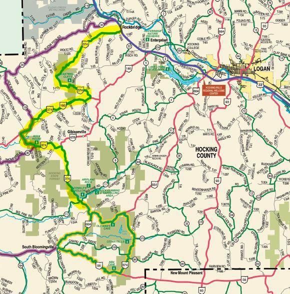
Hocking Hills Scenic Byway Driving Tour

              Byway Map

                                          1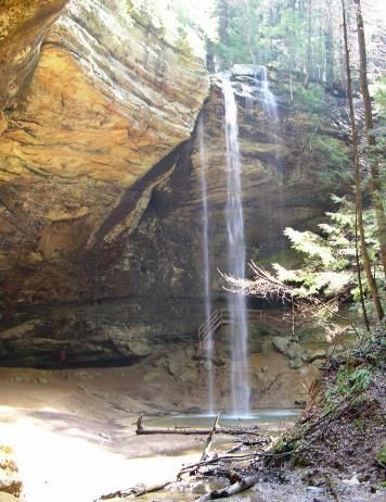
Hocking Hills Scenic Byway Driving Guide

   Welcome to the Hocking Hills Scenic Byway. This scenic drive will wind uphill
   and down through Ohio’s natural crown jewels, past the six non-contiguous
       sites of the Hocking Hills State Park and the Hocking State Forest.
GPS: N39º 32.184’ W082º 26.683’ (approaching the intersection of US 33 & SR 374)

                     The Hocking Hills Scenic Byway begins as you turn off US Route 33 onto Rt. 374
                     near Rockbridge, Ohio.

                     GPS: N39º 34.598’ W082º 31.348’ (at intersection)

                 More than 330 million years ago, the Hocking Hills State Park area was relatively
                 level and was covered by the waters of the Atlantic Ocean. For all those years, the
                 ocean’s currents deposited immense amounts of sand and gravel. After millions of
                 years, the ocean receded and formed the Black Hand Sandstone that underlies the
area. Appalachian Mountains arose, form and feature were cast upon the area and created Hocking
Hills. Peppered throughout these hills are cabins, lodges, Inns, yurts, treehouses, tipis and
campgrounds offering travelers one-of-a-kind accommodations. These hills also inspire artists and
craftsmen who have their works available in the many shops and galleries located throughout the
region. Marvel as glass is blown into works of art. Discover just how relaxing basket weaving can
be. Meet your inner artist with a painting class. Be entertained by local musicians playing
everything from bluegrass to classic rock favorites while enjoying an adult beverage at a local winery
or brewery. You can even indulge in authentic moonshine, legally, of course.

While you explore the Hocking Hills from the comfort of your car stop along the way at one of the
many parks you will pass. Take only pictures and leave only footprints. These natural gems are
Ohio’s crown jewels.

                                    GPS: N39º 33.231’ W082º 34.604’ (at entrance to Hocking State Forest)

                                    Now, take your time and enjoy the scenery. You are entering the
                                    Hocking State Forest area, nearly ten thousand acres of woodland
                                    splendor with hiking and bridle trails, rock climbing and rappelling areas.

                                    GPS: N39º 32.249’ W082º 34.622’ (approaching Cantwell Cliffs)
GPS: N39º 32.382’ W082º 34.537’ (at Cantwell Cliffs parking lot)

Mile 6

This is Cantwell Cliffs, the first Hocking Hills State Park site along the
Byway. The park was named for Joshia Cantwell. Although it is the least
visited park, many visitors proclaim the Cantwell area as the most
picturesque in Hocking County.

                                                                                                              2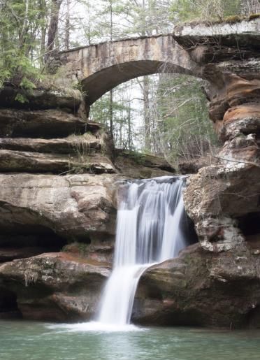
You will see a little log cabin which serves as office
                               headquarters for the park rangers during the
                               summer.

                          The deep valley, steep cliffs and rock shelters of
                          Cantwell Cliffs create a beautiful sight regardless of
the season. Trails wind up through narrow passageways caused by large slump
blocks that have fallen away from the main cliff. Cantwell Cliffs has a shelter house, as well as a
picnic area.

The hemlocks and pines are a pretty sight regardless of the time of year. Their
deep greens are especially welcome during the winter months. The parks
seem to have their own beauty in every season. Visitors are required by law to
stay on the trails for their own safety. Trail laws are strictly enforced.

Mile 7.5
                            1.5 miles past Cantwell Cliffs parking lot on Route 374 you will see a large grouping
                            of directional signs. Turn right to continue on 374 and the Scenic Byway route.

Mile 8.0
The beautiful rock cliffs edge the right of Stoody Hill (named for the farm owner).
                           The left side is a wonderful ravine with an old farm with the remains of a MailPouch
                           barn.
                           A picturesque wall of water can be seen on the right, across from Mt. Olive Road at
                           the bottom of Stoody Hill. In the winter, the seepage through the rocks forms
                           beautiful ice formations for the eye to enjoy.

                          Near a big log house is a small cemetery that belonged to the Hanson family. It is
taken care of by the Laurel township trustees.

Mile 9.7
At 23500 St. Rt. 180 in Rockbridge is Spirits of the Hills Fine Arts and Crafts Gallery.
The Hocking Hills Region is home to many artists. Open by appointment.
Mile 11.9
GPS: N39º 30.374’ W082º 37.359’ (approaching Mound Crossing)
GPS: N39º 30.369’ W082º 37.409’ (between house with mound and Grange Hall)

                              This is the Village of Mound Crossing. See the blue farmhouse with a
                              mound in its backyard. This mound was built by the Hopewell Indians
                              before the birth of Christ. St. Rt. 374 originally ran around this mound. The

                                                                                                                    3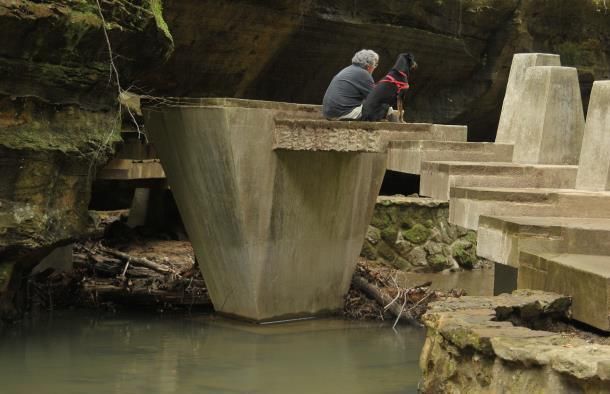
road was straightened and relocated about a half mile farther down. A few
pieces of flint were found when the original house was built.

Across the road from the mound is a Grange Hall. Established in the late
nineteenth century, the Grange, formally known as the Patrons of
Husbandry, was an organization created to assist farmers with the various
problems that they faced.

Mile 12.3
Make sure to turn left to continue on State Route 374.
GPS: N39º 30.311’ W082º 37.601’ ( State Route 374 turn)

Mile 13.4
GPS: N39º 29.768’ W082º 37.030’ (approaching Rock House)
GPS: N39º 29.740’ W082º 36.730’ (Rock House Trail Head)

On the left is Rock House, another park within the Hocking Hills State Park.

                             Rock House is the most unique of all the parks because it is a true cave. It is a
                            tunnel-like corridor situated midway up a 150-foot Blackhand Sandstone cliff
                            complete with seven Gothic-arched "windows" and great sandstone columns
                            which bear its massive roof. Rock House has a ceiling 25 feet high, while the
                            main corridor is 200 feet long and 20 to 30 feet wide.

                            Rock House was used by many past visitors as a shelter. You will find hominy
                            holes, small recesses in the rear wall which served as baking ovens for Native
                            Americans. Past visitors have chiseled out "troughs" or "holding tanks" in the
                            stone floor of Rock House. These were used in the melting of pine knots to
                            make turpentine, which was used by the Indians and pioneers for many
                            things. Local lore includes tales of robbers and bootleggers using Rock House
                            as a hideout.

                             Rock House has a colorful past and has long been a popular tourist attraction.
                             In 1835, Colonel F.F. Rempel of Logan erected a 16-room hotel compete with
                             ballroom, livery stable and a U.S. Post Office. The hotel stood where the
picnic shelter is today.

Rock House is a favorite site for photographers. Depending on the time of day, the light in Rock
House provides great colors and shadows waiting to be captured by even the most casual
photographer.
GPS: N39º 28.608’ W082º 35.102’ (Butterfly Ridge)

On the left is Butterfly Ridge, a butterfly conservation center and environmental education facility
with classes, seasonal daily guided tours and a one-mile hiking trail. Their mission is to develop
habitat for pollinators in general and butterflies specifically and to teach others to do the same.

                                                                                                                 4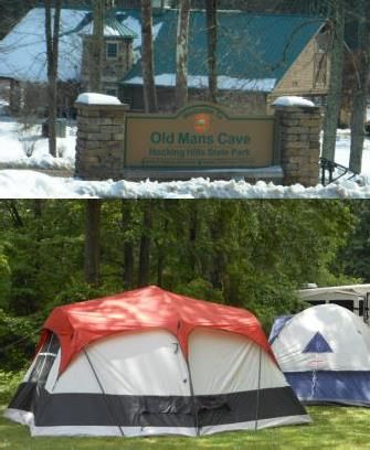
If you are visiting in July to September stop by the Hocking Hills Regional
                            Welcome Center at US 33 and State Route 664 to see the Monarch
                            Waystation. If your timing is right, you may get to witness a butterfly emerge
                            from its chrysalis.

Mile 18.1
GPS: N39º 27.527’ W082º 34.861’ (Hocking Honor Camp Trail)

The Hocking County Honor Camp opened in November 1950. Prisoners who were not a
flight risk planted trees, fought forest fires and helped take care of the parks. The
Hocking County Honor Camp was in operation from 1950 to 1974.

GPS: N39º 27.391’ W082º 34.740’ (State Forest Headquarters)

This is the Hocking State Forest Headquarters. In the 1930’s the state built the buildings
on this site to house the Civilian Conservation Corps who worked in the area planting
trees and clearing trails.

The Civilian Conservation Corps was one of the most successful New Deal programs of
the Great Depression. It existed for fewer than 10 years, but left a legacy of strong, handsome
roads, bridges, and buildings throughout the United States. Between 1933 and 1941, more than
3,000,000 men served in the CCC.

GPS: N39º 27.080’ W082º 34.521’ (approaching Big Pine & 374)
GPS: N39º 27.032’ W082º 34.392’ (at Big Pine & 374 intersection)

Mile 18.6
 A half mile past the Hocking State Forest Headquarters is Big Pine Road, where Conkle’s Hollow
State Nature Preserve is located Turn left on Big Pine Road and watch for Conkle’s Hollow State
Nature Preserve on your left. The little white church you see at the intersection of 374 and Big Pine
Road is Pine Grove United Methodist Church and Cemetery. It was constructed in 1886 with unique
architecture: it has two separate entrances, one door for the men and the other for the women.
Although some modernization has been done to the building, the original entry doors were left as a
comment on practices of the past. One of the graves in the cemetery belongs to Clyde Huffman, a
navy crewman of the USS Arizona. His body lies with his crewmen in Pearl Harbor in Hawaii. His
stone was placed at the church here as a memorial for him.

GPS: N39º 27.159’ W082º 34.296’ (entrance to Conkle’s Hollow)

                             Conkle’s Hollow Nature Preserve is a rugged, rocky gorge, one of the deepest
                             in Ohio. The timeless beauty of the rustic valley is surrounded by towering
                             240-foot Blackhand Sandstone cliffs protecting a wilderness of hemlocks,
                             birch, shrubs, ferns and wildflowers in this beautiful gorge. The hollow was
                             named for W.J. Conkle who left his name and the date 1797 carved into the

                                                                                                             5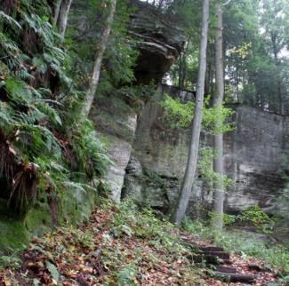
sandstone on the west wall of the gorge. There are two trails.
                           The gorge trail is handicap accessible and level. The rim trails
                           is much more challenging but adventurous hikers are
                           rewarded with breathtaking cliff-top vistas.

Conkle’s Hollow is a Nature Preserve and pets are not allowed. If you are traveling
with your pet, please return to Conkle’s Hollow without your pet. Please do not leave your pet in
your car.

GPS: N39º 26.402’ W082º 33.866’ (374/664 intersection)

Turn left and continue on State Route 374.

GPS: N39º 24.009’ W082º 33.264’ (at turn into John Glenn Astronomy Park)
GPS: N39º 25.875’ W082º 33.185’ (in John Glenn Astronomy Park parking lot)

                                  On June 21, 2018, the John Glenn Astronomy Park opened. The
                                  newest park site in the Hocking Hills State Park, the Astronomy
                                  Park connects visitors with the heavens in one of Ohio’s darkest
                                  night sky regions. Visitors to JGAP during the day get views of the
                                  Sun through telescopes with special filters. At night, visitors get a
                                  chance to see stunning views through the
enormous 28-inch telescope in the roll-off roof observatory. The moon,
planets, star clusters, nebulae and galaxies can be seen. Programs are
offered March through November however the Park is open year-round
and is equipped with power for personal telescopes.

Parking Reservations are highly recommended during the season. Reservations are free and must
be made online at registration.jgap.org.

Mile 21
                               The Hocking Hills Park System and rental cabins are at the end of a-mile-
                               long scenic driveway. The new Hocking Hills State Park Lodge is being
                               constructed on the same footprint as the former Dining Lodge and
                               Conference Center, which burnt down in December of 2016. This new
                               facility will offer visitors dining, conference space, and 81 guest rooms. The
                               date of opening is slated for October 2022.

Now you are approaching the most visited park within the Hocking Hills State Park, Old Man’s Cave.
GPS: N39º 26.215’ W082º 32.504’ (approaching Old Man’s Cave turn)
GPS: N39º 26.259’ W082º 32.379’ (at entrance to OMC parking)
GPS: N39º 26.129’ W082º 32.488’ (at HHSP new Visitor Center)

Mile 21.4
Old Man’s Cave is the hub of the Hocking Hills State Parks. In this park
the creek has carved a magnificent gorge through the entire depth of
                                                                                                            6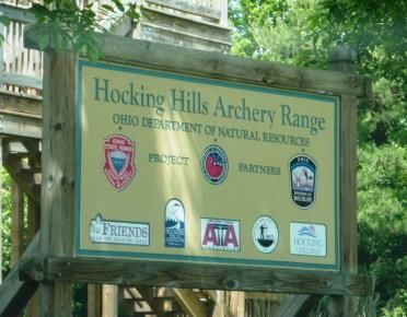
Blackhand Sandstone. There are 2 sections: the Upper Falls and the Lower Falls. Trails take you
down from one to the other. The vertical cliffs reveal deep recesses, potholes, and cracks that widen
in some places so that massive blocks of rocks have tumbled from the cliffs. The lush vegetation
                             varies and gives the eye a feast regardless of the season.

                                   The park gets its name for Richard Rowe, a hermit, who lived in the
                                   area with his dogs in the mid 1800’s and is reported to have stayed
                                   here until his death. Local legend tells of how the cave is haunted by
                                   Rowe to this day. There have been numerous reports of the ghostly
                                   sound of dogs baying at night coming from the deep gorge of Old
                                   Man’s Cave.

                              Don’t miss the State Park Visitors Center, which opened June, 2019.
                              This six-million-dollar, state-of-the-art, interactive center provides
                              visitors with hands-on exhibits highlighting the unique natural history
of the region. A large-scale cave built into the center of the room is designed to help visitors learn
about the geology of the region’s spectacular sandstone gorges.

There are 8,500 square feet of indoor exhibits, plus another 5,000 square feet of covered verandas.

Trail maps, safety tips, restrooms, water bottle filling stations, a gift shop and more are available to
everyone. There is plenty of great information available to make the most of a visit to all the parks
under the Hocking Hills State Park umbrella.

Turn right when exiting the parking area for Old Man’s Cave to continue on the Scenic Byway.

Mile 21.7
GPS: N39º 26.284’ W082º 32.301’ (Park and Campground Office)

On the right is the Hocking Hills State Park office, Naturalist and Park
Rangers offices. The road behind leads up to the State Park campground
which offers campers the choice of full hook-up, electric or primitive
sites. The Hocking Hills State Park Campground is very popular and has
trail access to Old Man’s Cave, Rose Lake and the Grandma Gatewood
Trail connecting Old Man’s Cave to Ash Cave. Early reservations for
prime camping seasons are highly recommended.

Mile 21.8
GPS: N39º 26.321’ W082º 32.163’ (Archery Range)

                          An outdoor archery range is located immediately north of the state park office
                          for the public's enjoyment. The new archery range features a variety of
                          targets suitable for all skill levels.

                                                                                                            7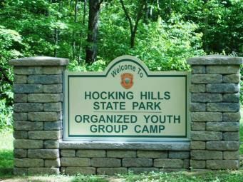
Mile 22.2 - Make sure you turn right to continue on State Route 374.
GPS: N39º 26.347’ W082º 32.006’ (approaching 664/374 intersection)
GPS: N39º 26.380’ W082º 31.855’ (at 374 turn)

Mountain Bike Trails
GPS: N39º 26.190’ W082º 31.689’ (turn off to Mountain Bike Trails)
GPS: N39º 26.177’ W082º 31.591’ (Mountain Bike trail head)

                                   Two mountain bike trails, each 2 miles in length, are located off State
                                   Route 374. The purple trail loop is moderate, and the orange trail loop is
                                   difficult.

                                   Mile 22.9
                                   GPS: N39º 25.951’ W082º 31.705’ (approaching Fishermen’s parking lot)
                                   GPS: N39º 25.927’ W082º 31.690’’ (in Fishermen’s parking lot)

                                   Rose Lake/Fishermen’s Parking
                                  -A parking area and trail access to Rose Lake is located on the left. The ½
                                  mile trail leads to Rose Lake, a man-made beauty amongst the hills
                                  popular for fishing, canoeing, kayaking and wildlife viewing.

Mile 24
GPS: N39º 25.087’ W082º 31.438’ (approaching Cedar Falls turn)
GPS: N39º 24.989’ W082º 31.477’ (at turn into Cedar Falls)
GPS: N39º 25.088’ W082º 31.579’ (at Cedar Falls trail head)

                                 Cedar Falls
                                 On the right, you will see the beautiful, curved block wall that graces the
                                 entry to Cedar Falls which has the greatest volume of water of all the falls
                                 in Hocking County, with water plunging 50 feet. It is easily the most
                                 photographed of waterfalls in Ohio. The name Cedar Falls is a misnomer,
                                 the result of mistaken identity. Early settlers to the area misidentified the
                                  stately hemlock trees as cedar trees; but the name Cedar Falls has been
                                  used ever since. Two deep grooves and numerous potholes have been
                                  created by the action of the stream as it cascades over the face of the
                                  Blackhand Sandstone. At one time a grist mill was located just above
                                  these falls. Cedar Falls is the mid-way point on the Grandma Gatewood
                                  Trail, part of Buckeye Trail System.

Every January the Winter Hike attracts thousands of hearty hikers as they trek from Old Man’s Cave,
stop at Cedar Falls for the Logan Kiwanis Club’s legendary Bean Soup and Corn Bread muffins before
continuing to Ash Cave where busses transport hikers back to Old Man’s Cave parking.

Mile 24.8
A few yards past Chapel Ridge Road look up over the tree line at the top of
the hill past Cedar Falls. You will see tucked away (almost hidden) on a
knoll, the Ash Cave Fire Tower. The tower was built in 1934 and still stands.
Visitors cannot climb the tower due to safety reasons. There were some
                                                                                                                 8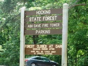
who wanted to raze the tower, but it still stands to become a monument to the many years of
service these towers provided in keeping our Hocking State Forest safe.

Mile 25 – HHSP Organized Youth Campground Entrance

GPS: N39º 23.652’ W082º 32.370’ (374/56 intersection)

Turn right, continue on State Route 56 and Ash Cave.

Mile 26.4
GPS: N39º 23.764’ W082º 32.722’ (Ash Cave)

                                   Most of the caves in the Hocking Hills are recess caves. Ash Cave is the
                                   largest and most impressive of this type of cave in the state of Ohio. The
                                   rim spans 700 feet around to form a sandstone horseshoe. A misty
                                   waterfall plunges 90 feet from the rim to the valley floor below. Huge
                                   mounds of ashes discovered here by early settlers are thought to be
                                   ancient campfires of early Indian inhabitants which gave this cave its
                                   name. The ashes were excavated in 1877 to reveal many Indian artifacts
                                   as well as bones of animals. The cave was a meeting place in early
                                   1800’s. The shelter is large enough to seat hundreds and the natural
                                   acoustics are excellent. Ash Cave became an official park in 1925.

                                   Continue along State Route 56 for 3.7 miles enjoying the rock
                                   outcroppings, small waterfalls, and creeks alongside the scenic route.

                             All along the Hocking Hills Scenic Byway you have passed cabins,
                             cottages, Inns and lodges. These unique accommodations are
considered to be an attraction in themselves as the quintessential Hocking Hills experience is as
much about relaxing in a cozy cabin, gathering the whole gang together in a spacious lodge or
indulging in a luxury Inn and Spa as it is about hiking and outdoor adventures.

GPS: N39º 25.062 W082º 35.985’ (56/664 intersection)

You have arrived in South Bloomingville, home to many of the area’s popular secluded cabins.

The Scenic Byway Route continues by turning right on State Route 664. In 2.8 miles you will be back
to State Route 374, completing the Byway.

GPS: N39º 26.385’ W082º 33.836’ (664/374 intersection)

Now you have an idea of just how much there is to see and do in the Hocking Hills. In addition to
the magnificent Hocking Hills State Park there are endless outdoor adventures. Take a tour by
horseback. How about a leisurely float down the Hocking River? Rent a pontoon boat and explore
Lake Logan. Fly through the tree canopy on zip lines. Climb a real rock face and rappel down. Drop
a line and catch dinner. Ride an ATV on specially designed trails. Visit a butterfly sanctuary. Tour

                                                                                                            9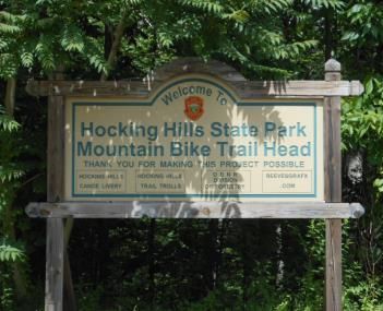
the last remaining washboard factory in the US. Reminisce about days gone by at the only Pencil
Sharpener Museum in the world.

Local entertainment is just as diverse as the landscape. Young people from our local schools deliver
on classic rock as if they had lived through those decades. Great local bands entertain in outdoor
venues, breweries and wineries for free. You’re surrounded by a community who knows what it
means to be authentic with a great big welcoming heart.

We hope you’ve enjoyed the Hocking Hills Scenic Byway and discovered new places to explore here
in Ohio’s natural crown jewels. Safe travels!

                                                                                                  10
You can also read