GTA West Transportation Corridor Route Planning, Preliminary Design and EA Study - Stage 2 - Community Engagement Webinar #2
←
→
Page content transcription
If your browser does not render page correctly, please read the page content below

GTA West Transportation
Corridor Route Planning,
Preliminary Design and EA
Study – Stage 2
Community Engagement Webinar #2
September 29, 2021

                                  1
Agenda
•   Welcome and introductions.
•   Overview of the GTA West Study.
•   Preferred Route and 2020 Focused Analysis Area (FAA).
•   Preliminary Design activities.
•   Summary of Community Value Plan Meeting #3.
•   Next steps.
•   Question and answer period.
•   Meeting close.

                                                            2
Housekeeping
• You can control the features you see (video, speaker view or full
  screen view, etc.).
• All attendees' web cameras and microphones will be turned off.
• To ask a question or provide a comment, please use the Q&A box.
• This event is being recorded.
• Questions submitted through the Q&A box tonight may be
  addressed later in the Q&A portion of this meeting and all
  questions asked in the Q&A box pertaining to the GTA West will be
  documented and responded to after the Webinar.

                                                                  3
Polling Questions

                    4
Introductory Questions
1) Have you considered the 407ETR as an alternative to a new
   highway? You should build truck priority lanes, subsidize tolls or
   buy back the 407ETR to encourage use.

2) Is the GTA West corridor needed if more people will be working
   from home in the future?

3) Has any construction started related to the GTA West corridor? If
   not, when will it start?

                                                                        5
Study
Overview
• Stage 1 (2008 –
2012) focused on
long-term
transportation
problems and
opportunities:
Optimizing the
existing
transportation and
transit network and
significantly
investing in transit
would not be
enough.
GTA West Highway
and Transit corridor
is still required.
6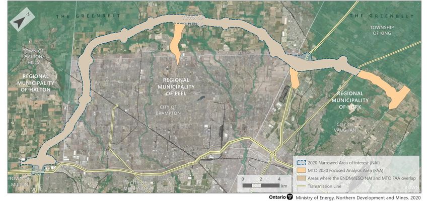
Study
Overview
• Stage 2 focuses on a
new highway and
transit corridor:
Extending from
Highway 401/407
ETR interchange
areas in the west to
Highway 400 in the
east.
Includes a 400-series
highway and transit
corridor, potential
goods movement
priority features, and
other potential
features like electric
vehicle charging
stations at carpool
lots.
7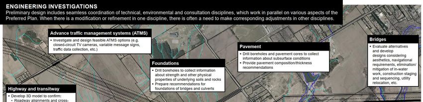
Federal Impact Assessment (IA)
• On May 3, 2021, the Federal Minister of Environment and Climate
Change determined the GTA West Study warrants designation
under the Impact Assessment Act (IAA).
We have started to develop an Initial Project Description (IPD).
Once submitted (anticipated early 2022), the Agency will consult with the Indigenous
communities and other stakeholders and prepare a Summary of Issues.
We will then prepare a Detailed Project Description (DPD).
After the DPD is submitted, the Agency must provide a decision regarding whether a
Federal Impact Assessment is required.
• A designation of the GTA West project for a Federal IA does not
replace the provincial Environmental Assessment (EA) process
underway.
We will continue with our planned public and Indigenous community consultations
and engagements.
Progressing with preliminary design and field investigations.
8
Polling Questions

                    9
• The need for the GTA West Study remains and is
strengthened by the GGH population and employment
growth forecasts, reflecting more people and jobs by 2041
and beyond. By 2051, the population of the GGH is
expected to grow to almost 15 million people, who will
represent approximately 7 million jobs.
Planning • Congestion already costs the GTA $11 billion per year in
lost productivity. Ontario needs new infrastructure to help
With Vision, move people and goods or the region will quickly become
overwhelmed.
Planning • We understand that some stakeholders are in support of
the project and some have concerns. We are striving to
For People arrive at a solution that provides the best balance of
benefits and impacts for the local communities and users
of the transportation system.
To accomplish this, we are committed to engaging and
consulting Indigenous communities, the public and
stakeholders in open two-way communication that
leads to meaningful discussions, proactive information
exchange and a constructive working relationship.
10Highway
• The corridor will initially be designed as a 4-
New Highway to 6-lane highway with a separate adjacent
transit corridor.
Corridor • The total proposed right-of-way (ROW) will
be 170m, of which the highway will be 110m.
11Polling Question
12Transitway
• The transit corridor will be 60m of the total ROW, run
parallel to the GTA West highway and will:
Allow buses (and potentially in the future, light rail
New Transit vehicles) to operate on express schedules.
Corridor Include stations at strategic locations and provide
transit connections with buses onto major arterial
roadways, Highway 401, 407ETR, Highway 410,
Highway 427, and Highway 400.
13Potential Goods Movement Priority Features
Truck Only Lanes Intelligent Transportation Systems Truck Parking Facilities
freightwaves.com Features (variable message signs, hornlogistic.com
real time traveler information)
Enhanced Design to Accommodate Longer Speed Change Lanes Enforcement Features
Long Combination Vehicles
semanticscholar.org (weight and inspection
stations)
bristoltruckrentals.com
14Future-Ready
• Ontario is a leader in the connected
and automated/autonomous vehicle
technology space.
• The GTA West highway and transit
corridor is future-ready by supporting
infrastructure for a connected corridor:
Vehicle to Infrastructure (V2I) shares
information in two directions.
Provisions for Road Side Units (RSUs) that
provide the connectivity and sharing of the
Basic Safety Message.
CAV Readiness Plan, March 2020
• Movement of goods through truck
platooning being considered.
15Preferred Route
162020 Focused Analysis Area (FAA)
• Purple Area is the 2020 FAA. Properties located in this area could be directly impacted by the multimodal
transportation corridor, ancillary uses, or if refinements are made to the route during preliminary design.
• MTO has reduced interest in properties in the Green Areas.
17Northwest GTA Transmission Corridor Identification Study
• In June 2019, the Ministry of Energy and the Independent Electricity System Operator initiated a
study to identify an electricity transmission corridor adjacent to the GTA West highway and transit
corridor.
This study is separate from the Ministry of Transportation’s GTA West Highway and Transit Corridor Study.
The two project teams are coordinating but are following different processes with different timelines.
Contact NWGTATransmissionCorridor@ontario.ca for information on the electricity transmission corridor study.
18Polling Questions
19Field Investigations
• Field investigations will inventory the natural, social, cultural and other
infrastructure features in the study area.
• Permission to enter properties have been received from some owners to allow
access to lands in order to obtain valuable field information that is helping to
develop the preliminary design of the Preferred Route.
Discipline Type of Field Investigation
Natural Environment Fisheries (2020 - 2022), Wildlife (2020 - 2022), Wetlands (2020 - 2022),
Vegetation (2020 - 2022)
Socio-Economic Environment Land Use (2021), Agriculture (2021), Potentially Contaminated Sites
(2021)
Cultural Environment Archaeology (anticipated 2022), Built Heritage (2020 & 2021), Cultural
Heritage Landscapes (2020 & 2021)
Engineering Fluvial Geomorphology (2020 & 2021), Drainage (2021), Structural (2021),
Foundations (2021), Pavement (2022), Electrical (2022), Erosion and
Sediment Control (2021)
20* The highway and transit corridor right-of-way is preliminary (alignment to be confirmed) .
21* The highway and transit corridor right-of-way is preliminary (alignment to be confirmed) .
22Study Process – Consultation & Engagement
• Public Information Centres (3 rounds).
• Community Workshops (4 rounds).
2 rounds focused on Community Value
Plans.
• Ongoing consultation and engagement with
Indigenous communities.
• Stakeholder advisory groups, municipal
working groups, meetings with landowners,
and Council presentations.
• Website, e-mail, toll-free telephone line,
Twitter, Ontario Government Notices, and
brochures.
• Additional public meetings – like tonight’s
Community Engagement Webinar.
23Summary of Community Value Plan (CVP)
Meeting #3 - May 2021
• The CVP is a collaborative process that includes
participation from residents, landowners, businesses
and other interested stakeholders from the community.
• The result will be design recommendations that
enhance the highway and transit corridor’s treatment of
landscape, cultural, social, historical and/or
environmental elements of value to the community.
• CVP Meeting #3 held in May 2021 further explored how
to incorporate public input into the design:
Aesthetics, landscaping, trails and wildlife crossings,
artistic elements at gateways and bridges,
buffering/protection of heritage sites, and others!
24Straw Model Designs Illustrating the CVP Toolkit
* CVP Toolkit is preliminary and subject to change
25Feedback From Community Value Plan Meeting #3
• Active transportation:
Pleased that transit stations will include active transportation features (e.g. bicycle parking) and trail connections.
Satisfied that the project team is working with conservation authorities and considering connections to their trails.
• Buffering treatments:
Interest in buffering mitigation at St. Stephen’s Hornby Anglican Church and St. Elias The Prophet Ukrainian
Church.
Interest in aesthetic treatments to buffer St. Elias Church property, which has heritage designation under the
Heritage Act.
Looking for measures to minimize impacts to the Valleywood community (e.g. noise, air quality, EMS access).
• Agriculture:
Continued interest in measures to move large agricultural equipment (e.g. appropriately sized underpasses to
avoid out-of-way travel to move between fields).
• Highway design:
Interest in OnRoute plazas and truck inspection stations along the corridor.
Continued interest in roundabouts at intersections with municipal roads.
• Next steps:
Refine the straw model designs, where necessary.
Once the noise impact assessment is complete, add recommended mitigation measures into the designs.
Ensure that any recommended measures to avoid, mitigate or compensate for potential impacts from other
disciplines are also included in the CVP designs.
The final CVP roll plans will be presented for comment at CVP Meeting #4, which will be combined with a future
Public Information Centre.
26Next Steps
Further develop the draft Community Value Plan and preliminary design of the
Preferred Route.
Continue to meet with Indigenous Communities, municipal staff, Regional
Fall 2021 – Early Municipal Councils.
2022
Public Information Centre is expected in late 2021.
Develop the Initial Project Description and submit to the Impact Assessment
Agency of Canada in early 2022.
* Schedule is subject to change
27Question & Answer
Period
28Polling Question
29Thank you for attending
We want to hear from you!
Project_team@highway413.ca
30You can also read