French River A Second Decade in the Canadian Heritage Rivers System Ten Year Monitoring Report: 1999-2007
←
→
Page content transcription
If your browser does not render page correctly, please read the page content below
French River
A Second Decade in the Canadian Heritage Rivers System
Ten Year Monitoring Report: 1999-2007

                                              Ontario Parks
                                              and
                                              The Canadian
                                              Heritage
                                              Rivers System

                                              Report Prepared
                                              by:
                                              Katherine Garrah
                                              Ontario Parks
                                              April 2008
ACKNOWLEDGEMENT

I wish to thank all those who helped me:
Chuck Miller; William Kershaw; Roel Teunissen; Leslie Joynt; Keith Scott; Mike Hall; Stephen Pianosi (Map author); and
all other persons I contacted during the writing of this report. Their assistance and attention to detail is greatly appreciated.

                                                  EXECUTIVE SUMMARY

This report focuses on the events that have occurred in the past ten years that are likely to influence the management of the
French River as a Canadian Heritage River.

Some important events that occurred between 1997 and 1999 have already been addressed in the prior monitoring document
(Coomber 1999). Thus some key items previously reported on have also been included in this report, as this is a “10 year”
report. Several events that have or are likely to happen beyond 2007, such as new fishing regulations and the expansion of a
major transportation corridor have also been included.

Over the last decade, French River Provincial Park and region have experienced important changes. Additions in 1997
(KIW) and 2007 (OLL) increased the park by over 43%. Additional representation and widening the park has significantly
enhanced the ecological integrity of the site. The Georgian Bay Littoral Biosphere Reserve designated by UNESCO in 2005
brought attention to the ecological integrity of the area by recognizing the importance of the broader ecosystem in the
aquatic context.

Park operations staffing (1990’s to present), trail improvements, a park map and the French River Visitor Centre enhanced
visitors’ understanding of the areas natural and human importance. The French River Recreation Bridge improved
snowmobile safety and provided visitors with access to a spectacular viewing platform. The change in status of the French
River from non-operating to operating over a three year period (2005-2007) has resulted in an ability to quantify contact
with overnight visitors, as well as improved, staffing and recreation management.
The French River Visitor Centre incorporates many facets of visitor education and relationship building between Ontario
Parks, area residents and First Nations communities. Ongoing management of the park includes consultation with local
committees such as the French River Joint Management Advisory Committee and the First Nations Aboriginal Advisory
Committee.

Related management activities of the Ministry of Natural Resources that benefit the French River include invasive species
awareness and monitoring, the regulation of enhanced management areas and updated fisheries regulations. The four-laning
of the primary north-south transportation corridor is ongoing and will impact areas adjacent to the park.

Please refer to the chronology of events for a more comprehensive outline of relevant events.

                                                          The French River: A Second Decade in the Canadian Heritage Rivers System
                                                                                             Ten Year Monitoring Report: 1999-2007
                                                                2
FOREWORD

This report on the French River has been prepared by Ontario Parks for Ontario Parks and the CHRS Board as a
requirement of the river’s CHRS designation.

The report fulfills two objectives:
    1. To permit the Canadian Heritage Rivers Board to review the present status of the French River as part of the CHRS
    2. To provide a record for interested individuals and agencies of the changes that have occurred to the river over its
        second ten years in the system, 1997 – 2007 inclusive.

This report highlights the natural and cultural heritage values, recreational opportunities and integrity values which were the
basis for nomination of the river to the CHRS in 1986. These values are within the boundaries of French River Provincial
Park which comprises the “management area” of the designated river. The relationship between the park values, adjacent
related features, and related internal and external management activities are also addressed in this document where
appropriate.

The previous monitoring report (1999) recognized two changes within the CHRS since the French Rivers’ designation that
affect the assessment of the river’s values:
     1. More specific integrity values
     2. National thematic framework
Please refer to the document “A Canadian Heritage Rivers Monitoring System Ten Year Monitoring Report on the French
River, Nick Coomber Heritage Planning, 1999, for further details regarding the French River from years 1986-1998.

In this second decade, the CHRS has released two key documents concerning river values, A Cultural Framework for
Canadian Heritage Rivers (CHRS 2000) and A Framework for the Natural Values of Canadian Heritage Rivers (CHRS
2001). The revised Frameworks are based on the experience gained over the trial period. The Cultural Heritage Values
Framework retains most of the original content with the following changes:

•   Acceptable element representations have been narrowed to include only those that are subject to traditional protected
    area planning and management. Values such as documents and offsite artifacts are now no longer acceptable
    representations, as they are not tangible and in situ within the immediate environment.
•   Themes were redefined and subdivided, and in some cases removed if they were difficult to represent or were
    extremely rare.
•   Activities representing modernity, of a ubiquitous nature or that cause environmental harm are no longer considered
    significant without some type of redeeming historical significance.

Within the Natural Values Framework, themes and the number of related sub-themes have remained unchanged, however
much content and concept in both have been significantly modified. These amendments provide better definition of what is
meant by a “Canadian Heritage River”.

This monitoring report updates the original Nomination Values as described in the original nomination document and in the
1999 Coomber Report, bringing them in line with the new reporting frameworks.

The report is divided into eight sections, four of which are integral to the reporting framework. Nomination values to be
reported on are discussed using original representation, current status, changes and/or threats and actions and related
research. Preceding text complements the information contained within the tables. In sections, important events that may not
necessarily be contained in the table are elaborated on. In some cases, information pre-dating 1997 was required to place the
events of the past decade in proper context, which results in a longer text but permits a fuller understanding of recent events.

The organization of the document follows a conventional sense and format based on previous CHRS reports. It provides a
broad perspective on the status of the French River while injecting relevant details. It attempts to bring the reader from their
chair into the complex and inviting story of the French River, and hopes to present the rivers’ past decade accurately and
without bias.

                                                         The French River: A Second Decade in the Canadian Heritage Rivers System
                                                                                            Ten Year Monitoring Report: 1999-2007
                                                               3
TABLE OF CONTENTS

Acknowledgement.........................................................................................................................................2
Executive Summary.......................................................................................................................................2
Forward .........................................................................................................................................................3
1.0 Introduction .........................................................................................................................................5
2.0 Overview of the French River .............................................................................................................5
    2.1 Chronology of Events .....................................................................................................................6
3.0 Natural Values ........................................................................................................................................8
    3.1 Background .....................................................................................................................................8
    3.2 Condition and Changes Since Last Report......................................................................................9
4.0 Cultural Values ..................................................................................................................................19
    4.1 Background ...................................................................................................................................19
    4.2 Condition and Changes Since Last Report....................................................................................19
5.0 Recreation Values..............................................................................................................................25
    5.1 Background ...................................................................................................................................25
    5.2 Condition and Changes Since Last Report....................................................................................26
6.0 Integrity Values .................................................................................................................................33
    6.1 Background ...................................................................................................................................33
    6.2 Condition and Changes Since Last Report....................................................................................34
7.0 Review of Current Park Management ...............................................................................................35
    7.1 Ontario Parks Guiding Management Documents..........................................................................38
8.0 References .........................................................................................................................................39
9.0 Appendices ........................................................................................................................................42
    9.1 Appendix A - Maps.......................................................................................................................42
    9.2 Appendix B - Additional Management ........................................................................................42
    9.3 Appendix C - Photo Index.............................................................................................................43

List of Tables

Table 1 - Chronology.....................................................................................................................................6
Table 2 - Natural Heritage Values...............................................................................................................13
Table 3 - Cultural Heritage Values..............................................................................................................21
Table 4 - Recreation Values ........................................................................................................................28
Table 5 - Integrity Values............................................................................................................................34
Table 6 - Management Direction.................................................................................................................36

List of Maps

Map 1 - French River Provincial Park – Pre OLL Boundary ......................................................................46
Map 2 - French River Provincial Park – Current Boundary ........................................................................47
Map 3 - French River Provincial Park – Zoning .........................................................................................48
Map 4 - French River Provincial Park – Watersheds and Dams .................................................................49

                                                                             The French River: A Second Decade in the Canadian Heritage Rivers System
                                                                                                                Ten Year Monitoring Report: 1999-2007
                                                                                     4
1.0 INTRODUCTION

In 1986, the French River was designated as a Canadian Heritage River, thus in 2007, it has been just over 20 years since
this river, the first of the CHRS designations, has been in the system. From the rivers beginning, it has taken a role in nature
and in people’s lives of considerable importance. The French has been a river in the core of North America, etched in the
Precambrian shield, surviving through glaciation, flowing in reversed direction for some time following the last continental
glaciation and adjusting to its modern role. Early Aboriginal inhabitants depended on the river for transportation, sustenance
and survival. Aboriginal culture and traditional knowledge were shaped by the river. These first people shared their
knowledge with settlers and travellers. French explorers Champlain, Brulé and others, would further define themselves in
these “new” lands, navigating the magnificent and maze-like channels. They were followed by Voyageurs and courier de
bois travelling the River on their arduous journey’s west and east in the name of Crown fur trade empires. Some settled,
feeling the pull of the land and the economic potential. Cottagers who came longed for the tranquility and reprieve.
Recreationists saw early the glory of the setting and challenge of the river, and entrepreneurs have made a living here,
supporting patrons of one of the most popular, reachable and diversified semi-remote tourist destinations in Ontario.

                                           It is these and other outstanding natural, cultural and recreational values that have
                                           made the French River such a spectacular and varied water body, recognized
                                           through its nomination and designation to the CHRS. Nominated in 1984, and
                                           designated in 1986 with the publishing of the French River Provincial Park
                                           Management Plan (1985), its’ CHRS status was officially unveiled by federal and
                                           provincial government representatives in 1986 with a CHRS plaque located at the
                                           Highway 69 river crossing.

                                           2.0 OVERVIEW OF THE FRENCH RIVER

                                           French River Provincial Park was regulated in April 1989. A waterway class park
  Interpretive Plaque at Recollet Falls.   in Ontario’s provincial parks system, the park originally encompassed 51,150
  (Photo courtesy of MNR Staff).           hectares of land, along the 110 kilometres of river from Lake Nipissing to Georgian
                                           Bay (Map 1). including the French River Delta. A 1997 addition through Ontario’s
“Keep It Wild” initiative resulted in a total protected area of 52,740 hectares.

In 2007, as a result of recommendations in Ontario’s Living Legacy Land Use Strategy (OMNR 1999) the French River
Additions were regulated as part of the French River Provincial Park. Grouped in two geographically distinct sections, the
eastern section is located on Lake Nipissing and the upper French River. The western section is located along the lower
French and Pickerel rivers, and includes areas adjacent to Georgian Bay. These additions were rationalized to enhance the
protection of natural features and management of recreation opportunities in the original park

Other lands and waters in addition to the above mainland portion have been regulated to fulfill the direction in Ontario’s
Living Legacy Land Use Strategy (OLL), 20,790 hectares of the 22,405 hectares originally suggested (OMNR 1999). Some
islands (1,651ha) within the original OLL area in Georgian Bay remain to be regulated. These islands were not included in
regulation as there is a need to work with First Nations to resolve Aboriginal interests. Today, the park encompasses an area
of 73,530 hectares.

Nine townships within the Municipality of French River, as well as farming and tourism centres, surround the park. Four
First Nation communities, Dokis No. 9, French River No. 13, Henvey Inlet No. 2 and Point Grondine No. 3, abut the
boundaries of the Park. Many other active first nations communities in the area have an ongoing interest and continue to use
and affiliate with the French River.

                                                          The French River: A Second Decade in the Canadian Heritage Rivers System
                                                                                             Ten Year Monitoring Report: 1999-2007
                                                                5
2.1 CHRONOLOGY OF EVENTS

    Table 1. Chronology of Events for the French River since 1999 1
    Year       Significant Events, Actions, Research or Studies since 1999                                          In Park      Adjacent
    Ongoing Water flow monitoring by Environment Canada Water Services Canada since
               the early 1960’s. Confirmed data is available until 12/31/05. Data beyond that is
               provisional. Only two monitoring stations remain active – Dry Pine Bay
               (regulated) and N. French R. near mouth (natural).
    Ongoing Increased awareness of Species at Rick, especially Eastern Massasauga
               Rattlesnake through education and interpretation at French River Visitor Centre.
    Ongoing Budget allows for one seasonal part-time Conservation Officer to patrol the
               French River during shoulder seasons and into the winter.
    Ongoing French River Delta Association (FRDA) host annual French River clean-up.
    1989 -     French River Joint Management Advisory Committee composed of resort
    Ongoing owners, cottagers and local First Nations provide suggestions to Park
               Superintendent. Committee meets semi-annually.
    1990 -     Land Claim and Statement of Claim from Wikwemikong First Nation includes
    Ongoing islands in Georgian Bay, 1,615 ha of which will be indicated by OMNR to
               become part of the French River OLL addition in 1999.
    1992 -     Friends of the French River Heritage Park (FFRHP) continue their support of
    Ongoing and involvement with the French River.
    1993       First full Management Plan Review – to address policy changes provincially.
    1997       “Keep it Wild” initiative adds Stony Rapids, eastern Eighteen Mile Island and
               Five Finger Rapid areas (1,590 hectares) to the park for a total protected area of
               52,740 hectares.
    1998       Water Services Canada discontinues monitoring at Portage Dam, Chaudière
               Dam and French River at Lake Nipissing.
    1998 -     Regulated water levels hover around the mean while unregulated water levels on
    Ongoing Georgian Bay and Lake Huron fall sharply. In 2007, water levels remain below
               their long-term mean (NOAA 2007).
    1999       Management Plan Minor Amendment: 99-01 – changes the nature reserve zone
               referred to as NR2: Eastern Massasauga Rattlesnake Habitat to NR2: French
               River Island Wildlife Habitat.
    1999       “Ontario’s Living Legacy” (OLL) proposes to add P110 – French River
               Additions to increase park area by 22,405 hectares.
    1999       Municipality of French River is formed - amalgamates nine townships including
               the settlements Alban, French River Station, Ouellette, and Monetville.
    1999       Great Lakes Heritage Coast policy statement provides for special planning -
               incorporates land two kilometres inland from the shoreline of Georgian Bay,
               including the French River area (OMNR 1999).
    1999         Enhanced Management Areas protect adjacent lands as per Ontario’s Living
                 Legacy Land Use Strategy (1999).
    1999         Land use change. Nipissing First Nation privately purchases culturally
                 significant pre-archaic burial site on Frank’s Bay adjacent to park, and shares it
                 in principle with Dokis First Nation and others.
    1999         Prosecution by Fisheries and Oceans Canada for removal of beaver dam results
                 in $7,500 fine for locals. Fine monies support rehabilitating fish habitat
    1999 -       Elk are reintroduced east of Killarney and North of French River mouth to
    2001         supplement existing population. Early and late winter surveys are flown
                 annually (1999 – 2008).
    2000         Meshaw Falls annual walleye egg harvesting and fish stocking program initiated
                 in 1995 is cancelled due to negative implications for fishery.

1
    This table would otherwise exclude events that occurred prior to 1997, but some relevant events are nonetheless included.
                                                                        The French River: A Second Decade in the Canadian Heritage Rivers System
                                                                                                                 Ten Year Monitoring Report: 1999-2007
                                                                           6
Year          Significant Events, Actions, Research or Studies since 1999                                    In Park     Adjacent
    2000          Stage II Archaeological Assessment prior to construction of French River
                  Visitor Centre. No cultural heritage resources were identified. Prepared by
                  Woodland Heritage Services Limited.
    2000 -        French River Visitor Centre funding approval, panning and consultation –
    2002          including confirmation that no Species at Risk (SAR), specifically, Eastern
                  Massasauga rattlesnake present at building site.
    2002          Management Plan Minor Amendment: 02-01 – allows the Otter Bay
                  snowmobile trail and bridge in natural environment zone NE2.
    2002          Management Plan Minor Amendment: 2002-01 – provides for the rezoning of a
                  2ha portion of historical zone H3: Recollet Falls to allow for the expansion of
                  development zone D1: Voyageur Lookout to accommodate the Visitor Centre’s
                  footprint.
    2002          Management Plan Minor Amendment: 2002-02 – permits Pickerel River Bridge
                  crossing just south of Hwy. 69 river crossing in Natural Environment zone NE2.
    2002          Otter Bay Snowmobile Bridge and Trail constructed on Little French
    2002          Woodland Heritage Services Limited compiles archaeological assessment of
                  remainder of proposed building site. No cultural heritage resources identified.
    2002          French River Visitor Centre Environmental Study Report. Prepared by Baird
                  Sampson Neuert Architects Inc.
    2002 -        French River Provincial Park Recreation Bridge planning, consultation and
    2004          construction phases.
    2002 -        French River Visitor Centre and exhibits under construction.
    2006
    2002 -        First Nations Aboriginal Advisory Committee created to advise of First Nations
    Ongoing       involvement and ideas for Visitor Centre.
    2003          Management Plan Major Amendment: 01-03 – allows the French River
                  Recreation Bridge and snowmobile trail in development zone D1.
    2003          French River Recreation Bridge - Environmental Study Report. Prepared by
                  Great Lakes Environmental Services.
    2003          Pickerel River Snowmobile Bridge installed.
    2003 -        Greater Georgian Bay Reptile Awareness Program educates the public and
    2004          stakeholders about conservation needs of 11 reptile species in the Parry Sound –
                  Muskoka Area.
    2004          Sediment monitoring by Environment Canada’s Water Survey Canada cancelled
                  in 2003-2004. Sediment monitoring program had been in place since c.1960.
    2005          Georgian Bay Littoral designated World Biosphere Reserve by UNESCO 2 . The
                  347,000 hectare area includes extensive shoreline, open water and adjacent
                  mainland.
    2004-         5-year logging plan abutting park boundary - considers area values ex. Park and
    2009          other Areas of Concern.
    2005          French River Recreation Bridge is installed following an Environmental Study
                  Report and Management Plan amendment.
    2005          French River Provincial Park becomes operational, begins 3-year phase-in; Park
                  begins collecting fees and issuing park permits at nine lodges and resorts along
                  the river.
    2005          Joint Heritage River Canoe Trip - representatives from First Nations, OMNR
                  and Ontario Parks paddle in traditional 24-foot North Canoe. Trip route: Dokis
                  to Frank’s Bay and return.
    2005          Ontario Parks staffing increases on the French River and at the Visitor Centre
    2005          Class Environmental Assessment for Provincial Parks and Conservation
                  Reserves - legislation with implications to greater transparency of planning

2
    United Nations Educational, Scientific and Cultural Organization
                                                                       The French River: A Second Decade in the Canadian Heritage Rivers System
                                                                                                          Ten Year Monitoring Report: 1999-2007
                                                                             7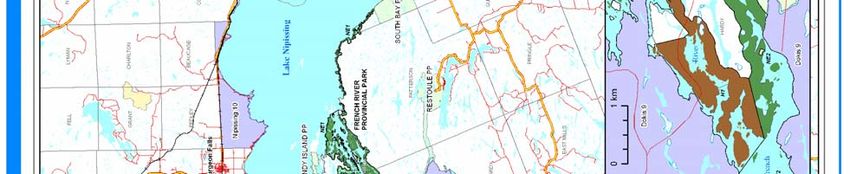
Year        Significant Events, Actions, Research or Studies since 1999                            In Park      Adjacent
 2005 -      Additional operating dollars enable field crews to rehabilitate campsites, install
 2006        over 100 pit toilets, sign and GPS campsite locations; crews decommission 50
             unsustainable campsites.
 2006        French River Visitor Centre opens. Project totalled $5.6M. The centre receives
             50,000+ visitors annually and has been nominated for / won numerous awards.
 2006        Technical Guidelines for Cultural Heritage Resources for projects planned under
             the Class Environmental Assessment for Provincial Parks and Conservation
             Reserves is published.
 2006        CBC “Studio 2” films short documentary about the French River
 2006        Eastern Georgian Bay Stewardship Council is established, stemming from the
             formation of the Georgian Bay / North Channel Stewardship Council in 2000.
             The area includes the Lower French River north to Allen Lake and east to
             Highway 69 (approximately)
 2006        Expansion of Park Boundary, regulation beyond 200m boundary incorporates
             adjacent water bodies and adopts ecological boundaries. Deregulation of water
             located under provincial highways.
 2006 -      Local First Nations and Ontario Parks rehabilitate abandoned parking area
 2007        adjacent to Visitor Centre
 2006 -      Reptile [Eastern Massasauga rattlesnake] awareness at French River Visitor
 Ongoing     Centre
 2007        French River Water Quality Stewardship Committee created. Ontario Parks not
             directly involved, however OMNR is the lead agency
 2007        New Provincial Parks and Conservation Reserves Act (2006) - maintain and
             increase Ecological Integrity is first priority.
 2007        Management Plan Minor Amendment - adds policy direction for mainland
             portions of French River Park Additions total 73,530 hectares. Georgian Bay
             islands portion not included pending resolution of Aboriginal interests.
 2007        Journey 2007 – Festival of Peoples co-hosted by the French River Visitor Centre
             First Nation and Aboriginal Advisory Committee, Ontario Parks, and MNR
             Parry Sound District. Over 1500 people attended a traditional First Nation Pow-
             Wow and Métis Rendezvous
 2007        Tests done by the Ministry of the Environment confirm blue-green algae bloom.
             (cyanobacteria) Samples taken from 18 Mile Bay contained Anabaena, a
             species capable of producing toxins
 2008        New Ontario fisheries regulations for 2008/09. French River regulations remain
             unchanged from 2007. See Recreational Fishing Regulations Summary for detail
 2008        Intention to fully remove Recollet Falls Tramway
 Ongoing     Planning for highway 69 four-laning will add new bridges over French River
 - 2009      (six crossings in total: two rail lines, four bridges)

3.0 NATURAL HERITAGE VALUES

          3.1 BACKGROUND

The French River nomination document (CHRS 1984) identifies the
following key natural heritage features:

    •     Representation of Earth History:
              -   Stratigraphy and structural features of the Grenville
                  Province during ancient mountain building
              -   Preglacial river erosional features some 40,000 years
                  ago                                                          Narrow channel of the French River framed by
              -   Glacial ice moulding landscapes on the Canadian              steep granite walls. (Photo courtesy of MNR
                  Shield including extensive delta on Georgian Bay             Staff).

                                                        The French River: A Second Decade in the Canadian Heritage Rivers System
                                                                                           Ten Year Monitoring Report: 1999-2007
                                                              8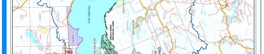
•     Representation of Ongoing Processes:
                 -   Post glacial plant and animal migration corridor using indicator species
                 -   Transitional Boreal and Great Lakes Forests with range extensions for flora from both regions

       •     Unique or Outstanding Biophysical Area:
                 -   450 plant species documented; 40 are considered important to understanding vegetation community
                     structures, 8 identified as provincially rare at the time of designation
                 -   Outstanding landform: Bedrock delta on Georgian Bay - habitat for an abundance in Ontario of Virginia
                     Chain Fern; the largest most northerly roadless habitat for the threatened Eastern Massasauga rattlesnake;
                     provincially significant productive Yellow Pickerel spawning and feeding areas

       •     And
                   -   Numerous areas of exceptional natural beauty, including narrow bedrock controlled channels where
                       scenery changes with a variety of islands, rapids and falls. These include:
                             Ì    Bad River Voyageur Channel, Canoe Channel, Flat Rapids, Recollet Falls, Five Mile Rapids,
                                  Five Finger Rapids, Little French River, and Upper French River

             3.2 CONDITION AND CHANGES SINCE LAST REPORT

Non-Native Species

Viral Hemorrhagic Septicaemia 3 (VHS), documented for the first time in Lake Ontario in 2005, has been confirmed as far
north as Lake Huron (OFAH, Undated). However, the definition of virus-positive waters includes adjoining water bodies –
lakes Ontario, Erie and Huron (including Georgian Bay) and connecting waterways and tributaries up to the first impassable
barrier, excluding fishways. This includes the Lower French River east to Highway 69 and the Key and Pickerel Rivers up
to the first impassable barriers (OMNR 2007a). Key management strategies dictate that fish, bait, clothing and equipment
from the management area cannot be moved outside the virus-positive waters, but like items from outside virus-positive
waters can be used within the management area (OMNR 2007a).

Rhodophyta (Bangia atropurpurea) has been confirmed in the Great Lakes, but has not yet been confirmed in the French
River. This type of algae was found at 43 sites in 1995 and 39 sites in 2002. In 2002, rhodophyta was confirmed for the first
time on Georgian Bay, as well as in the St. Lawrence River and Lake Simcoe, indicating that this species is spreading (Shea
et al. 2003).

The plant species purple loosestrife (Lythrum salicaria) has been confirmed in Lake Nipissing and in the Lower French
River area (OFAH 2008a).

The fish species round goby (Neogobius melanostomus ) has not been confirmed on the French River, but has been
documented along the North Shore of Georgian Bay (OFAH 2008b).

Spiny water flea (Bythotrephes cederstroemi) has been reported in Lake Nipissing and north of the French River along the
shores of Georgian Bay (OFAH 2008c). The spiny water flea is likely in the river as well, since all water from Lake
Nipissing must flow through the French River to Georgian Bay.

Zebra mussels (Dreissena polymorpha) have been observed and confirmed by the OFAH at the mouth of the French River
and in water bodies south of L. Nipissing (OFAH 2008d). Anecdotally, it is well known that zebra mussels have invaded the
French River. Interestingly, scientists have also found a link between zebra mussels and the occurrence of toxic blue-green
algal blooms, or microcystis. Zebra mussels will spit microcystis into the water while at the same time, eat other algae that
may be competitors with or help control microcystis. Zebra mussels also produce nutrients that further fertilize microcystis.
(OFAH 2008d).

Water Quality

The water in the river has tested "good" for many years (UFRCA 2004). Since 1993, the Upper French River Cottagers
Association (UFRCA) has engaged in water testing. Until 2004, this included semi-annual testing for E.coli (Escherichia
coli), total phosphate, dissolved oxygen, chlorophyll A, nitrate and nitrite. The program cost $900 per year and results had a

3
    VHS is an infectious viral disease of fish, which results in early mortality.
                                                                          The French River: A Second Decade in the Canadian Heritage Rivers System
                                                                                                             Ten Year Monitoring Report: 1999-2007
                                                                         9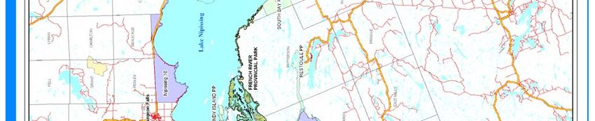
slow turn around time. In 2005 a new, faster water-testing program was developed between the UFRCA, Near North
Laboratories and FRI Ecological Services that tested for more representative and functional variables: E.coli, Coliform,
water temperature, dissolved oxygen, phosphorous and water clarity observations. Since, the testing has been done monthly
from May to October. The UFRCA obtained a one-time grant of $3200 from TD Friends of the Environment to help cover
the capital cost of the new program. The results of the testing are posted as samples are completed, and are shared with the
Ministry of the Environment (MOE) and Dokis First Nation (UFRCA 2004).

Tests conducted by the MOE confirmed the presence Blue Green Algae Blue-green algae (Cyanobacteria) from Wolesley
Bay to Dry Pine Bay in the fall of 2007. The samples collected from 18 Mile Bay contained the species Anabaena, which is
capable of producing toxins. The presence of toxins was not confirmed in the river, however while the algae was in bloom
the Sudbury District Health Unit suggested taking precautions (Northern Life 2007). It is not known whether this is the first
case of Cyanobacteria or the first reported case on the French River.

Elk Rehabilitation

Elk or Wapiti (Cervus elaphus) were once native to Ontario, along with moose (Alces alces), caribou (Rangifer tarandus)
and deer (Odocoileus virginianus). By the late 1800’s, the elk population in North America had been reduced from pre-
European settlement numbers of 10,000,000, to 100,000. Due to unregulated sport hunting, market hunting and loss of
habitat due to human settlement, they were entirely extirpated from Ontario

During the early 1940’s an attempt to restore the population was made, specifically in the Burwash area. However by the
mid 1940’s , there were fears that elk were acting as vectors for a parasite (called the giant liver fluke) with the potential for
infecting domestic cattle. This assumption resulted in a deliberate attempt to extirpate elk from the province.

Efforts at extermination had only partial success and with the completion of a
study by Bruce Ranta in 1979, it was accepted that the attempt to eliminate
elk had not been warranted. By this time only a small remnant population of
elk from the Burwash - French River area had survived

In 1993, Dr. Josef Hamr of Cambrian College, began to study the herd to
determine its status and try to find out why elk numbers were not increasing.
Use of radio-telemetry collars showed that there were two herds each in good
condition and with good reproductive rates. The problem appeared to be that
the elk population was too small to counteract periodic mortalities from               Elk, once naturally occurring in healthy herds,
drowning, and train collisions. In 1996 the OMNR entered into a partnership            were extirpated from the Ontario in the 1800’s.
to restore elk. The Provincial Elk Restoration Advisory Committee (PERAC)              They have since been introduced with success
                                                                                       especially in the French River – Burwash area.
was established to coordinate the effort.                                              (Photo courtesy of MNR Staff).

In 1998 a shipment of 47 elk arrived in Sudbury from Alberta. They were held over winter and then released. Their post-
release movements were followed using radio telemetry in order to assess habitat use, mortality events and to monitor
reproduction.

To date, 460 elk have been brought into Ontario, 187 of which have been released in the Nipissing -French River area.
Aerial surveys are flown in early and late winter in order to assess calf recruitment and survival in the French River and
Burwash areas. The 2007 early winter survey showed an increase in the known number of cows and calves (M. Hall. pers.
comm. April 2008).

French River Fisheries

The French River walleye (Stizostedion vitreum) stocks have received significant funds in the past to perform various
annual population assessments, such as creel surveys, angler interviews, netting surveys and walleye samples. The FWIN
(Fall Walleye Index Netting) population assessment method was used from 1993 onward with the initiation of the French
River Recovery Plan (1992). A partnership between the OMNR and Laurentain Universities’ French River Cooperative
Fisheries Unit (FRCFU) allowed the completion of these annual studies again from 2000-2003. Future assessment work will
start with a proposed FWIN in 2009 (K. Scott. pers. comm. 3 April, 2007.).

Prior to 1980, the French River walleye stocks were some of the largest and most productive walleye stocks known in
Ontario. Fishing pressure increased drastically throughout the 70’s and 80’s and stocks declined to record levels. The
decline posed a serious threat to the sustainability of the fishery and the population. This resulted in the formation of the
                                                          The French River: A Second Decade in the Canadian Heritage Rivers System
                                                                                             Ten Year Monitoring Report: 1999-2007
                                                                10
French River Community Fisheries Enhancement Committee (FRCFEC) to address the issue. The committee consisted of
representatives from OMNR, the Ministry of Culture Tourism and Recreation, Environment Canada, Dokis First Nation,
OFAH, Ontario Hydro, Laurentian University and local stakeholders.
Measures were taken to assess the stock and habitat. The FRCFEC advised and supported an OMNR decision to restrict
walleye slots to between 38 and 64 centimetres, protecting the breeding fish and significantly limiting the allowable harvest.
The consequent success of the decision - improved population and fish sizes - supported the restrictions.
Between 1995 and 2000 the Community Fisheries and Wildlife Involvement Program (CFWIP) Meshaw Falls Eggs
collection and spawning assessment was active on the Central French, effectively live trapping and harvesting eggs from all
spawning walleye. The stress induced by the netting combined with the removal of potential fry caused greater damage to
the stock than benefits. This was compounded by degraded spawning habitat from road siltation. Though CFWIP stocked
walleye annually, the fish were not of the same genetic strain and thus competed with endemic strains, or were not as fit.
Eggs that were harvested from French River walleye were hatched but often stocked in other area lakes (K. Scott, pers.
comm.29 January, 2008).
In 2000 the walleye population in the Eastern and Western French, traditionally both productive walleye habitat, had
increased 160% and 32% from 1993 levels, respectively. The Central French River, which is not considered to be prime
walleye habitat, had experienced a 45% decrease and appeared to be collapsing (Harrow and Morgan, 2000).
Aware of the disparity and receiving public concerns, the OMNR contracted an engineering firm to rehabilitate this portion
of the riverbed and suspended the Egg Collection and Spawning Assessment program. With even greater recoveries then
observed in the walleye population, the CFWIP hatchery building was permanently relinquished to private owners in 2003
(Heerschap 2003). Since, walleye populations on the French have recovered so successfully, and already with some pressure
from local fishers, the OMNR may consider relaxing the slot size from 38 centimetres to 42 centimetres in 2010 (K. Scott,
pers. comm. 29 January, 2008).
Next steps of the Recovery Plan have been discussed at a public meeting in
2005. The French River Community Fisheries Enhancement Committee
persists, however it is not as active as it once was due to the success already
seen. This is the best example in the province of Ontario of a threatened
fishery and a collapsed populations’ recovery. Anglers, lodge owners and
OMNR personnel are extremely happy with the outcome. Although stocks in
the central French remain status quo, the fishery in the Eastern and Western
French has improved dramatically to pre-collapse levels (Harrow and
Morgan, 2000). The French River Recovery Plan continues to be funded by
OMNR.
Climate change and warming water trends are likely to be the cause of an
increase in large (Micropterus salmoides) and small mouth bass (M.
dolomieui) populations. These species compete with endemic populations,
Recreational anglers employ fishing guides
through commercial lodges and resorts. (Photo such as walleye, for resources. It has been suggested that, an increase in
courtesy of MNR Staff). catch limit or an adjustment of slot sizes for greater harvest may be
appropriate for bass on the French River in the future (K. Scott, pers.
comm.29 January, 2008).
Northern pike (Esox lucius) populations are experiencing a decline, as noted from anecdotal reports and from creel surveys.
Although the scientific research usually focuses on walleye populations, this observation suggests that more attention will
be paid and an adjustment to restrict the northern pike fishery may be considered in future regulations.
The French River Fisheries Study (1992-1998) found that Muskellunge (Esox masquinongy) are considered a fragile
resource as the top predator in their ecosystem, and that size limits less than 122 centimetres would not sustain the
population. As the public supports a trophy fishery on the French River, the more restrictive slot length remains at 122
centimetres in 2008.
Managers of the contiguous Pickerel River, located in Parry Sound District, attempted to harmonize fishing regulations
between the two rivers by adopting the more restrictive 1998 French River slot sizes and limits. The French River fish
stocks can easily travel between the two jurisdictions, supporting the need for identical regulations. In 2005, however, it was
The French River: A Second Decade in the Canadian Heritage Rivers System
Ten Year Monitoring Report: 1999-2007
11confirmed that despite efforts, local protest was so adamant that rather than continue pushing for identical regulations, Parry
Sound District would concede to identical catch limits for bass, pike and walleye, and same catch and size limits for
Muskellunge. With the new Ecological Framework for Recreational Fisheries Management (OMNR 2005e), standardized
regulations for the Pickerel River have been implemented, though harmonization with the French is not intended to be
pursued at this time (E. McIntyre. pers. comm. 13 June, 2005).
Reptiles
Between 2002-2006, the federally funded Canadian Wildlife Stewardship
Program project, the “Greater Georgian Bay Reptile Awareness
Program” was dedicated to public education, strong landowner
involvement, and stewardship. The program recognized development and
visitation pressures in the Georgian Bay area, the likelihood of increased
human-reptile conflict and the potential loss of important habitat. The
project educated members of the public about the natural history,
distribution, status, and conservation needs of 11 reptile species,
including the Eastern Massasauga rattlesnake. Workshops and
educational materials were offered. Direct landowner contact, response to
inquiries and extensive media coverage was promoted. In each year since
the Canadian Wildlife Stewardship Program supplied funding (beginning
Eastern Massasauga rattlesnake, Sistrurus
2001), the and its habitat have received funding for related projects, catenatus (Photo courtesy of MNR Staff).
though not necessarily in the Georgian Bay or French River area (CWS
2007).
Other
July 17, 2006 Windstorm
On July 17, 2006, an extremely destructive windstorm passed though the Georgian Bay area. The French River region was
one of the hardest hit areas. From Chaudière Lodge to Sandy Island, vast numbers of trees, mostly pine, were felled by the
strong wings. Damage to property has not been estimated, though anecdotally the damage was significant. Salvage
operations in the Nipissing Forest to harvest the blow down were planned for these areas in addition to what had been
approved in the 2004-09 Forest Management Plan (UFRCA 2006). The harvest operation did not include any areas within
the Park.
French River Water Quality Stewardship Committee
Formed in February of 2007 and with an executive committee composed of representatives from the Ontario Ministry of
Natural Resources, the Sudbury District Health Unit, the Ontario Ministry of the Environment, and a cross-section of local
citizens, the committee engages individuals interested in maintaining or increasing the water quality of the French River.
With membership at large approximated at over 100, the committee holds an annual public meeting focusing on river water
quality. The committee has pursued involvement with Ontario Parks and local First Nations communities, which are both
involved though not formally represented on the committee. Projects undertaken include phosphorus sampling and
monitoring of indicator species such as crayfish and amphibian populations (Palmer, M. Pers. Comm. 10 April, 2008).
Forest Management Plan Review
The Current Forest Management Plan (FMP) for the French River area is prescribed from 1999-2009. From 2007 to 2009,
plans are made for the next 10-year management plan 2009-2019 (UFRCA 2007).
Water Levels
Water Levels in the Great Lakes are of concern at this time. Between 1965-1997, water levels were generally above their
long-term mean, however in 1998 lake levels fell sharply. Lakes Superior, Michigan and Huron, including Georgian Bay,
remain well below their long-terms means and are continuing to drop. Lakes Ontario, St. Clair and Erie are once again
above long term means. Variations in weather patterns may play a role, the low level lakes having experienced unusual
drought conditions in past years (NOAA 2007). The French River is a regulated waterway, and thus water levels remain
predictable despite the drop in Georgian Bay.
The French River: A Second Decade in the Canadian Heritage Rivers System
Ten Year Monitoring Report: 1999-2007
12Eastern Georgian Bay Stewardship Council
Established in 2006 under the OMNR’s Stewardship Network, the Eastern Georgian Bay Stewardship Council (EGBSC) is
primarily water-based and fisheries oriented. Their mandate includes a land and water component, as well as a strong
fisheries component. The council originates from the Georgian Bay / North Channel Fisheries Stewardship Council created
in 2000. With the introduction of new sport fishing regulations in 2003, the council shifted its focus from regulatory
advisory to the co-management and stewardship council that is active today. The EGBSC area of authority includes,
approximately, the Lower French River north to Allen Lake and east to Highway 69 (EGBSC 2006).
Georgian Bay Littoral Biosphere Reserve
The 13th Biosphere Reserve in Canada and the 4th in Ontario, the Georgian Bay Littoral was designated as a World
Biosphere Reserve by the United Nations Educational, Scientific and Cultural Organization (UNESCO) on November 5,
2005. It covers 347,000 hectares and includes extensive shoreline, open waters and adjacent mainland. The reserve also
encourages sustainable economic and human development focusing on ‘smart-growth’ ecotourism. It promotes
environmental education, research and monitoring of activities (GBLT 2008).
Cormorant Management
In the Lake Huron Area, approximately 98 of 108 active double-crested Cormorant (Phalocrocorax auritus) nesting
colonies are found on the Ontario side of Lake Huron. The majority of these are located in Georgian Bay and the North
Channel. This population increased drastically since the late 1980’s. Growing 60% between 1997 and 2001, the population
peaked in 2000-2001. Since, the population has decreased by over 20%, though the negative association between
cormorants and depleted fisheries is still strong (OMNR 2006). One study aimed to determine the scale of the cormorant
population in the area relative to the fish. An element of this study included reducing the population by oiling eggs and
attempting to determine the interrelationship between predator and prey (Ridgeway et al. 2006).
As per the document Review of the Population Status and Management of Double-crested Cormorants in Ontario (OMNR
2006) cormorant control will only be considered in “specific local areas if the birds are found to be having significant
negative, ecological impacts on habitats or other species”. Two recent guiding policy documents Ontario’s Biodiversity
Strategy (OMNR 2005c) and Our Sustainable Future (OMNR 2005d) emphasize the conservation of natural resources and
maintaining biodiversity while protecting human and health and economic growth (OMNR 2006). There has been no lethal
cormorant management taken within the park. Park management documents will help guide the management of any
excessive population.
Table 2. Natural Heritage Values of the French River 4
Theme / Sub-theme / Element Theme Representation Changes since 1999 Actions and Related
in 1986 and Threats to Research
Condition
1.0 Hydrology
1.1.5 Drainage Basin Atlantic Ocean Basin - Viral Hemorrhagic Management Programs
St. Lawrence River Septicaemia (VHS) has are in place to help stop
System drainage basin. been introduced in the the spread. VHS has not
French R. is a lake- Great Lakes. yet reached Georgian
influenced system, Bay or the French River,
includes Lake Nipissing, though they are part of
Wolesley Bay, Eighteen the management area.
Mile Bay as main 2005 designation of the
influences. Georgian Bay Littoral
Biosphere Reserve.
4
As the intention of the reporting framework has been significantly revised since the last report, some features will have been recorded under their new
elements. Where an element did not exist previously it has been noted.
The French River: A Second Decade in the Canadian Heritage Rivers System
Ten Year Monitoring Report: 1999-2007
13Theme / Sub-theme / Element Theme Representation Changes since 1999 Actions and Related
in 1986 and Threats to Research
Condition
1.2.3 Seasonal Variation Temperate spring peak - Water levels in the Numerous organizations
May. Entire River. Great Lakes are are attempting to
Dams and Pickerel River approaching an all-time determine the cause of
help to prevent major low. Water control the water loss, though
fluctuations in water structures combat this studies continue to
levels. effect on the French contradict the findings of
River. others.
Possibly due to climate
change, freeze-up may
be later and break-up
may be earlier.
Anecdotal evidence to
support.
1.3.1 Water Content (Upper Insignificant sediment Last record of sediment Sediment monitoring
French) load (phys); low total in 1997 recorded one program by WSC
dissolved solids (chem) measurement (May) cancelled in 2003. Water
dissolved solids of 83 Quality measurements
mg/L at French River made by UFRCA and
near the Mouth Near North Laboratories
states water quality is
good
1.3.2 Water Content (Lower Minor sediment load Last record of sediment Sediment monitoring
French) (phys); low total in 2000 recorded program by WSC
dissolved solids (chem) average. July/August cancelled in 2003.
dissolved solids of 1106
mg/L at Dry Pine Bay. Noëlville Lagoons
managed by Ontario
Noëlville Lagoons are Clean Water Agency and
drained into river at tested prior to draining.
high water levels Lagoons currently
operate at 35% capacity.
1.4 River Size Small River. Mean Mean annual flow at Only two monitoring
annual flow of 51-91 Mouth of 96.5 m3/s, stations remain active -
m3/s. Stream Order 2. min = 70.1; max = 126 Dry Pine Bay (regulated)
River increases by 30% (1986 - 2007) Mean and North French near
below Pickerel River annual flow at Dry Pine the mouth (natural)
junction. Bay of 182 m3/s, min =
97; max = 232 (1986 -
2006)
2.0 Physiography
2.2.5 Geological Processes: Sedimentation. Gneisses, None. French River Visitor
Bedrock Formation slates, schists, rhyolites Centre exhibits
of the Grenville
Province
Part of the Canadian
Shield - Laurentian
Region.
The French River: A Second Decade in the Canadian Heritage Rivers System
Ten Year Monitoring Report: 1999-2007
14Theme / Sub-theme / Element Theme Representation Changes since 1999 Actions and Related
in 1986 and Threats to Research
Condition
2.2.9 Geological Processes: Glacial Scouring and ‘P’ None. French River Visitor
Surficial Material forms. Striations, Centre exhibits
Formation polishing, grooves,
kettles.
Scarps within the park
on north side of Fourteen
Mile Island.
Plutons on Burnt Island,
Pine Cove, Emma Lake,
French River Gorge
2.2.6 Glacial melting Oversize channels, French River Visitor
potholes, spillways, Centre exhibits
glacial lake deposits.
Potholes at Meshaw
Falls below Portage
Dam, and other
locations. Glacial
Rebound. Reversal of
flow of pro-glacial Lake
Algonquin.
Ice-moulded shorelines,
striations, grooves near
Rainbow Camp Boat
Tramway, French R.
delta
2.3.4 Hydrology Bedrock Type: None.
Impervious (Igneous and
Metamorphic) of
Grenville Province
throughout corridor.
Surficial Unconsolidated
Materials: High
Porosity. Thin Soils and
Barrens.
2.4.4 Topography Steep Gradient >5m/km None. French River Visitor
Height Above Sea . Centre exhibits
Level: 0-400m.
Shallow gradient, middle
section - stepped.
3.0 River Morphology
3.2.1 Channel Patterns Almost straight None.
Straight Channels channels, often with
angular bends and
bedrock.
Classic features of pre-
glacial river erosion -
bedrock 'delta', Main
Channel.
Narrow bedrock
controlled channels on
main channel below
Highway 69 bridge.
The French River: A Second Decade in the Canadian Heritage Rivers System
Ten Year Monitoring Report: 1999-2007
15Theme / Sub-theme / Element Theme Representation Changes since 1999 Actions and Related
in 1986 and Threats to Research
Condition
3.2.5 Branching Streams Channels separated by None.
significant land
masses, including
vegetated bars. Includes
river distributaries,
including those in
deltas.
3.2.11 Elongated Lakes River section is None.
essentially an elongated
lake, possibly a drowned
channel, flowing only at
outlets.
3.3.7 Channel Profile Major eddy or vortex None.
Whirlpool with backflow,
associated with deeps
and channel bends.
Stony Rapids, Five
Finger Rapids, Five Mile
Rapids, Flat Rapids,
Jameson Rapids, Bad
River Rapids.
3.3.9 Ledge Type Waterfalls Abrupt, level drop None.
extending across river
channel, ex. Recollet
Falls, Dallas Rapids
4.0 Biotic Environments
4.1.2 Lake Systems Mesotrophic Lakes, such
as Sturgeon Lakes,
Island Lake, Bear Lake
4.1.10 Aquatic Ecosystems Bogs and Fens:
Numerous examples
throughout the river
Swamps: Numerous
examples in geological
depressions
4.2.9 Terrestrial Ecosystems Located in Ecodistrict/s Park additions include
5E-7 and 5E-5 5 Natural Areas: 1) French
River to Key River 2)
Travers Township and
Voyageur Channel 3)
Struthers Township
Upland Forest.
Boreal Shield Ecozone Logging is occurring in Forest Management Plan
the area but is not for 2009-2019 will be
permitted within Park reviewed in 2007/08.
boundaries. Current forest
management plan will
harvest several areas
near park boundary.
5
Ontario is divided into 13 ecoregions. An ecoregion is an area of land within which the response of vegetation to the features of landform follows a
consistent pattern. Ecoregion 5E is called Georgian Bay. Ontario is divided into 65 ecodistricts. An ecodistrict is a subdivision of an ecoregion based on a
characteristic pattern of physiographic features, which set apart fairly large areas from one another (OMNR 2004).
The French River: A Second Decade in the Canadian Heritage Rivers System
Ten Year Monitoring Report: 1999-2007
16Theme / Sub-theme / Element Theme Representation Changes since 1999 Actions and Related
in 1986 and Threats to Research
Condition
Narrow river corridor Campsites are located so
concentrates as to distribute camping
recreational pressure pressure along the
narrow corridors.
5.0 Vegetation
5.1.5 Significant Plant Virginia chain fern Clustered sedge (Carex
5.1.6 Communities. Extent and (Woodwardia virginica) cumulata) Canada's St.
Location - largest community in John’s wort (Hypericum
Canada at river mouth. canadense), Farwell's
5 provincially rare flora: water milfoil
Blunt-lobed Grapefern (Myriophyllum
(Botrychium oneidense), farwellii) are not
mat panic grass currently considered
(Panicum meridionale), provincially rare. They
secund rush (Juncus are rated S4 and are
secundus), Giant listed in a larger
pinedrops (Pterospora database.
andromedea) and
scentless chamomile 6
(Matricaria maritima
Virginia chain fern,
ssp. phaeocephala).
Woodwardia virginica.
Distributed in small
(Photo courtesy of MNR Staff).
pockets throughout
corridor.
5.1.7 Vascular Plants - Dynamic Post glacial migration None.
corridor for vascular
plants
5.2.4 Rare Plant Species Provincially rare: Report: Provincially and
Blunt-lobed Grapefern Regionally Rare
Secund rush Vascular Plants -
Giant pinedrops Ecoregion 5E.
-W.B. Crins 2004.
For a [more] complete
listing of rare plants Report: Locally Rare
found in these Vascular Plants - Site
ecodistricts (5E and 5E- District 5E-7.
7, refer to Crins 2004. -W.B. Crins 2004.
6.0 Fauna
6.1 Significant Animal
Populations
6.1.1 Exceptional population size Yellow pickerel, Historic decline in The egg harvest and
- Fish provincially significant population due to over spawning program has
spawning and feeding fishing has been been cancelled.
areas. reversed due to FWIN method
Largest populations are significant rehabilitation population assessment
in the lower river and the efforts by government, approximately every 5
'delta' area. public, private and years by the OMNR in
educational institutions conjunction with
and groups. Laurentian University's
FRCFU.
6
M. maritime ssp. Phaeocephala is a native subspecies, not to be confused with the invasive subspecies M. perforata.
The French River: A Second Decade in the Canadian Heritage Rivers System
Ten Year Monitoring Report: 1999-2007
17You can also read