First Geodetic Observations Using New VLBI Stations ASKAP-29 and WARK12M
←
→
Page content transcription
If your browser does not render page correctly, please read the page content below
CSIRO PUBLISHING
                    www.publish.csiro.au/journals/pasa                                            Publications of the Astronomical Society of Australia, 2011, 28, 107–116

                            First Geodetic Observations Using New VLBI Stations
                            ASKAP-29 and WARK12M

                            Leonid PetrovA,G, Chris PhillipsB, Tasso TzioumisB, Bruce StansbyC, Cormac ReynoldsC,
                            Hayley E. BignallC, Sergei GulyaevD, Tim NatuschD, Neville PalmerE, David CollettF,
                            John E. ReynoldsB, Shaun W. AmyB, Randall WaythC, and Steven J. TingayC
                            A
                              ADNET Systems, Inc./NASA GSFC, Code 610.2, Greenbelt, MD 20771, USA
                            B
                              CSIRO Astronomy and Space Science, PO Box 76, Epping, NSW 1710, Australia
                            C
                              International Centre for Radio Astronomy Research, Curtin University, Bentley,
                              WA 6102, Australia
                            D
                              Institute for Radio Astronomy and Space Research, Auckland University of Technology,
                              Private Bag 92006, Auckland 1142, New Zealand
                            E
                              GNS Science, PO Box 30368, Lower Hutt 5040, New Zealand
                            F
                              Land Information New Zealand, 160 Lambton Quay, PO Box 5501,
                              Wellington 6145, New Zealand
                            G
                              Corresponding author. Email: Leonid.Petrov@lpetrov.net

                            Received 2010 December 20, accepted 2011 February 9

                            Abstract: We report the results of a successful 7-hour 1.4 GHz Very Long Baseline Interferometry (VLBI)
                            experiment using two new stations, ASKAP-29 located in Western Australia and WARK12M located on
                            the North Island of New Zealand. This was the first geodetic VLBI observing session with the participation
                            of these new stations. We have determined the positions of ASKAP-29 and WARK12M. Random errors on
                            position estimates are 150–200 mm for the vertical component and 40–50 mm for the horizontal component.
                            Systematic errors caused by the unmodeled ionosphere path delay may reach 1.3 m for the vertical component.

                            Keywords: instrumentation: interferometers — techniques: interferometric — reference systems

                    1 Introduction                                                                        a new 12-m antenna at Warkworth near Auckland —
                    As part of the joint bid by Australia and New Zealand                                 New Zealand’s first research-capable radio telescope
                    to host the multi-billion dollar Square Kilometre Array                               (Gulyaev & Natusch 2009).
                    (SKA), both countries are investing heavily in advanced                                  A joint Australia and New Zealand collaborative
                    technologies for radio astronomy. In Australia this fol-                              project is focused on developing both the ASKAP and
                    lows a strong tradition in radio astronomy and is expres-                             Warkworth facilities as part of regional and global VLBI
                    sed in the construction of the Australian SKA Pathfinder                              arrays, for the purposes of both astronomy and geodesy.
                    (ASKAP) on the western edge of the Australian continent                               Due to the dearth of land mass in the Southern Hemi-
                    (Johnston et al. 2008). Radio astronomy in New Zealand                                sphere, both astronomical and geodetic VLBI has suffered
                    has links stretching back to the work of Elizabeth                                    in the past, with the radio telescopes used for VLBI
                    Alexander on solar radio emission (Alexander 1946).                                   restricted to the south-east ‘corner’ of the Australian
                    John Bolton and Gordon Stanley used a cliff interferom-                               continent, one telescope in South Africa and occasional
                    eter to obtain rising and setting records of various radio                            use of radio telescopes in Antarctica and South America.
                    sources (Bolton 1982); measurements made near Sydney                                     The additional capability gained by adding radio tele-
                    and Auckland allowed them to identify mysterious                                      scopes located in Western Australia and New Zealand
                    ‘radiostars’ with well-known supernova remnants and                                   is substantial, increasing the angular resolution of the
                    galaxies (Bolton, Stanley & Slee 1949). The first                                     Australasian array by a factor of approximately four,
                    successful Very Long Baseline Interferometry (VLBI)                                   admitting a range of astronomy science goals described
                    experiment between Australia and New Zealand was                                      in Johnston et al. (2008).
                    made in 2005 with a 6-m radio telescope near Auckland                                    High-precision astrometry is likely to be an important
                    (Karaka) and the Australia Telescope Compact Array                                    part of the science case for the high–angular resolution
                    (ATCA) (Gulyaev et al. 2005; Tingay et al. 2006). In                                  component of the SKA, in particular for precise determi-
                    2008, Auckland University of Technology commissioned                                  nation of the distances of radio pulsars in the galaxy, to be

                    Ó Astronomical Society of Australia 2011                                                                           10.1071/AS10048         1323-3580/11/02107

Downloaded from https://www.cambridge.org/core. IP address: 46.4.80.155, on 27 Sep 2021 at 04:07:40, subject to the Cambridge Core terms of use, available at https://www.cambridge.org/core/terms
. https://doi.org/10.1071/AS10048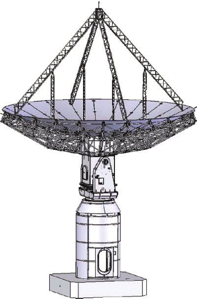
108                                                                                                                                               L. Petrov et al.

        used in various tests of fundamental physics (Smits et al.                            experiments using the full LBA network with the partici-
        2010). In order to achieve the astrometric performance                                pation of the two new stations: (1) imaging observations
        required, the SKA will need to undertake astrometry                                   of PKS 1934–638 on 2010 April 29–30 (Tzioumis et al.
        utilising distributed clusters of small antennas operating                            2010a), (2) a geodetic experiment on 2010 May 07, and
        as phased arrays. This is a departure from standard                                   (3) imaging onbservations of Cen-A on 2010 May 09
        precision astrometry and our work using ASKAP as part                                 (Tingay et al. 2010, in preparation).
        of a VLBI array for astrometry will be an important                                       We report here results from the geodetic experiment
        testbed for the demonstration of these techniques.                                    that was conducted at ASKAP-29 and during the first
           The 12-m radio telescope WARK12M1 is intended to be                                geodetic observing session on 2010 May 07. The goal
        used as a part of the Australian Long Baseline Array                                  of this experiment was to determine the position of the
        (LBA), for spacecraft monitoring, and for VLBI observa-                               antennas with decimeter accuracy and to collect diagnos-
        tions in the framework of the International VLBI Service                              tic data. The characteristics of new antennas are presented
        for Geodesy & Astrometry (IVS)2 and the AuScope                                       in section 2. The experiment and its analysis are described
        project.3                                                                             in sections 3 and 4. Concluding remarks are made in
           ASKAP-29 is an element of the ASKAP array of 36                                    section 5.
        identical dishes using Phased Array Feed (PAF) technol-
        ogies, expected to be fully operational by 2013. ASKAP                                2 New Antennas
        will undertake very wide field survey science in continu-
                                                                                              2.1   ASKAP-29
        um and spectral line modes and is also intended to be used
        as a part of regional and global VLBI networks for a                                  The Australian SKA Pathfinder (ASKAP) is an advanced-
        variety of projects.4                                                                 technology radio telescope currently under construction
           As a part of commissioning the new antennas, the                                   at the Murchison Radio-astronomy Observatory (MRO)
        positions of antenna reference points should be deter-                                in Western Australia. The ASKAP array comprises 36
        mined. A reference point is defined as the point of the                               fully steerable dish antennas of 12-metre aperture fitted
        projection of the movable elevation axis onto the fixed                               with phased array feed (PAF) receivers, giving an
        azimuthal axis. For the analysis of VLBI source-imaging                               instantaneous field of view of approximately 30 square
        experiments made in a phase-referencing mode, the                                     degrees with an instantaneous bandwidth of 300 MHz in
        projection of a baseline vector (i.e. vector between                                  the range 700–1800 MHz.
        antenna reference points) onto the tangential image plane                                 The first antenna, ASKAP-29, was commissioned in
        should be known with errors not exceeding tens of                                     March 2010 and was temporarily fitted with a conven-
        centimetres, otherwise the image will be smeared                                      tional horn (single-pixel) L-band feed (1.4 GHz) and
        (Charlot 2002). For astrometry applications, angular                                  uncooled receiver. Five additional antennas were com-
        position accuracies of tens of m as are required, making                              pleted in Q4 2010 with the balance to be commissioned
        the requirements on the accuracy of station positions                                 throughout 2011.
        much more stringent: 5–10 mm. One way of estimating                                       The antenna is of a prime focus design with an
        the position of the antenna reference points is through                               unshaped paraboloidal reflector of f/D 0.5. The original
        analysis of a combination of a ground survey of markers                               specifications on surface accuracy were 1 mm root mean
        attached to the antennas from a local network around the                              square (rms). However, measurements showed that the
        station and GPS observations from the points at the local                             surface accuracy of the ASKAP-29 reflector and six other
        network (see e.g. Sarti, Sillard & Vittuari 2004; Sarti,                              identical antennas manufactured by November 2010 is
        Abbondanza & Vittuari 2009). Another way to estimate                                  better than 0.5 mm rms over the full elevation range.
        station positions is to use the VLBI technique itself to                              There is some flexure in the position of the focus at a
        determine group delays and then derive reference point                                level of few mm over the full elevation range, but this
        positions from these group delay measurements. The                                    can be compensated for if required. This level of surface
        advantage of this approach is that it also provides useful                            accuracy implies that the antenna will be usable at
        diagnostics on the VLBI equipment.                                                    frequencies as high as Ka band (30 GHz) and possibly
           The first fringe-test experiment between ASKAP-29                                  at Q band (43 GHz). A quadripod supports the prime focus
        and WARK12M was made in April 2010. First fringes                                     platform with maximum payload of about 200 kg. Addi-
        on baselines between ASKAP-29 and MOPRA were found                                    tional bracing supports on each leg have been added to the
        on 2010 April 22 and on baselines to WARK12M on the                                   original design to reduce flexure.
        following day. This success prompted three first science                                  An unusual feature of the antenna is the three-axis
                                                                                              mount. Above the familiar azimuth and elevation axes is
        1                                                                                     the so-called polarization axis, allowing the entire reflec-
          WARK12M and ASKAP-29 are identifiers for specific VLBI antennas:
        near Warkworth, New Zealand and at the Murchison Radio-Astronomy                      tor to be rotated about its optical axis. This design was
        Observatory, Western Australia, respectively.                                         specified to allow full parallactic angle tracking for high
        2                                                                                     dynamic range in imaging observations, as it improves
            http://ivscc.gsfc.nasa.gov/.
        3                                                                                     modeling of far-out sidelobes caused by the quadripod.
            http://www.auscope.org.au/.
        4                                                                                     An equatorial (‘HA–Dec’) design naturally maintains a
            http://www.atnf.csiro.au/SKA/.

Downloaded from https://www.cambridge.org/core. IP address: 46.4.80.155, on 27 Sep 2021 at 04:07:40, subject to the Cambridge Core terms of use, available at https://www.cambridge.org/core/terms
. https://doi.org/10.1071/AS10048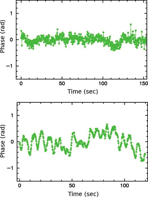
First Geodetic Observations at ASKAP-29 and WARK12M 109
Figure 1 ASKAP antenna.
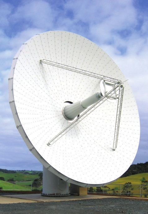
constant orientation of its focal plane with respect to the Figure 2 WARK12M antenna.
celestial sphere when tracking a fixed point in celestial
coordinates. However this type of mount usually suffers
restricted sky coverage due to limited rotation in hour conversion process in order to match the configuration of
angle. LBADR recorders used at other stations.
Another feature of the antenna is the relatively large
2.2 WARK12M
pedestal specified to accommodate the analogue and
digital electronics for the PAF receiver with its 188 The New Zealand 12-m radio telescope (see Figure 2) is
individual ports. The 54th Research Institute of China located some 60 km north of the city of Auckland, near the
Electronics Technology Group Corporation (known as township of Warkworth. It was manufactured by Patriot
CETC54) are contracted to design, manufacture and Antenna Systems (now Cobham Antenna Systems), USA.
install all thirty-six antennas at the MRO. The antenna specifications are provided in Table 2. The
The baseband data at ASKAP-29 were recorded directly radio telescope was originally designed to operate at S
to disk utilising a custom recording system developed at (2.3 GHz) and X bands (8.4 GHz) and it was supplied with
Curtin University. The recording systems were assembled an S/X dual-band dual-polarisation feed. Photogramme-
from consumer off-the-shelf components. The recorders try observations showed that the surface rms accuracy is
were interfaced with the CSIRO supplied analogue down- 0.35 mm. Therefore, the antenna is suitable for observa-
converters. The systems recorded the data to disk at the tions at frequencies as high as 43 GHz. It is equipped with
native sampler/digitizer sample size of 16 bits. a digital base-band converter (DBBC) developed by the
The 16-bit sample size gives an aggregate data Italian Institute of Radio Astronomy, a Symmetricom
rate when sampled at the Nyquist–Shannon rate over 2 Active Hydrogen Maser MHM-2010 (75001–114) and
polarization channels of 4 Gbit/s. The recorder system with the Mark5Bþ data recorder developed at MIT
comprised a Signatec PX14400 PCIe sampler/digitizer Haystack Observatory. However these were not installed
mounted in a server-class computer. The systems were at the time of this experiment, so data were recorded with
built in a 16-disk chassis populated with SATA hard the same equipment as installed at ASKAP-29.
drives. The recording system utilised a Linux software The antenna elevation axis is at a height of approxi-
RAID, and the 16 disks where subdivided into 8-disk mately 7.1 m above the ground level. The elevation axis is
RAID units. The recorded data were converted to the supported by a pedestal of steel construction. The pedestal
LBA format with 2-bit samples after the experiment is essentially a steel cylinder of ,2.5 m diameter. Apart
using software employing automatic gain control in the from the pedestal all other components of the antenna (the
Downloaded from https://www.cambridge.org/core. IP address: 46.4.80.155, on 27 Sep 2021 at 04:07:40, subject to the Cambridge Core terms of use, available at https://www.cambridge.org/core/terms
. https://doi.org/10.1071/AS10048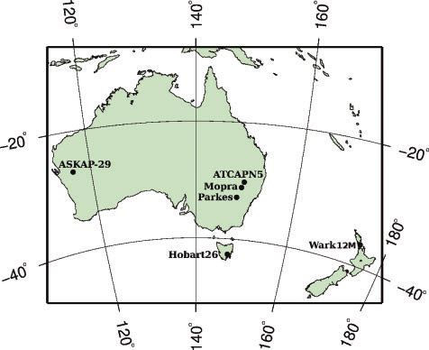
110                                                                                                                                               L. Petrov et al.

                   Table 1. Specifications of an ASKAP antenna                                                   Table 3. The network stations

        Antenna type                    Fully-steerable, prime focus                          Name                       fgd                     l                  Diam.
        Reflector                       12-metre paraboloid
                                                                                              ASKAP-29                268.69                 1168.64                12 m
        Surface accuracy                0.5 mm rms or better
                                                                                              ATCAPN5                 308.31                 1498.56                22 m
        Mount                           3 axes: polarization, elevation, azimuth
                                                                                              HOBART26                428.81                 1478.44                26 m
        Height of elev. axis            7.51 m above concrete foundation
        Azimuth axis range              1808 to þ3608                                        MOPRA                   318.27                 1498.10                22 m
        Azimuth axis speed              38/s                                                  PARKES                  338.00                 1488.26                64 m
                                                                                              WARK12M                 368.43                 1748.66                12 m
        Azimuth axis accel.             38/s2
        Elevation axis range            158 to 898
        Elevation axis speed            18/s
        Elevation axis accel.           18/s2
        Polarization axis range         1808 to þ1808
                                                                                                  WARK was established in November 2008 at the radio
        Polarization axis speed         38/s                                                  telescope site and is one of thirty-nine PositioNZ network
        Polarization axis accel.        38/s2                                                 stations (Blick & Collett 2010) in New Zealand.5 All
                                                                                              data received from the PositioNZ stations are compiled
                                                                                              into 24-hour sessions and are processed to produce daily
                                                                                              positions for each station in terms of ITRF2000.6 The
                 Table 2. Specifications of a WARK12M antenna                                 coordinates for WARK used in the following calculations
                                                                                              were derived by averaging the daily coordinate solutions
        Antenna type                   Fully-steerable, dual-shaped Cassegrain                for 2010 February 19 through March 09.
        Manufacturer                   Cobham/Patriot, USA                                        The RTK reference receiver was set up in an arbitrary
        Main dish diam.                12.1 m                                                 location with clear sky view and was configured to record
        Secondary refl. diam.          1.8 m                                                  raw observations in addition to transmitting real-time
        Focal length                   4.538 m
        Surface accuracy               0.35 mm
                                                                                              corrections. This station was later post-processed with
        Pointing accuracy              1800                                                   respect to WARK and all RTK rover-surveyed positions
        Frequency range                1.4–43 GHz                                             were subsequently adjusted relative to the updated refer-
        Mount                          alt-azimuth                                            ence position.
        Azimuth axis range             908  2708                                                 Several points on the rim of the main reflector were
        Elevation axis range           4.58 to 888
        Azimuth axis max speed         58/s
                                                                                              identified and each point was measured several times with
        Elevation axis max speed       18/s                                                   the RTK rover while the telescope was repositioned in
        Main dish f/D ratio            0.375                                                  elevation and azimuth between successive measurements.
                                                                                              The rover GPS antenna was mounted on a 0.5-m survey
                                                                                              pole and was held by hand for each measurement. Access
        reflector and feed support structure) are constructed of                              to the rim of the reflector was achieved with a hydraulic
        aluminum. The support foundation for the antenna is a                                 cherry picker.
        reinforced concrete pad that is 1.22 m thick by 6.7  6.7                                 The sequence of observation for determination of the
        meters square. The ground that the foundation is laid                                 horizontal axis was as follows. The telescope azimuth
        on consists of weathered sandstone/mudstone, i.e. it is                               axis was held fixed (nominally 08). A point near the
        of sedimentary origin, laid down in the Miocene period                                highest edge of the reflector was identified and measured
        some 20 million years ago.                                                            with the telescope in four positions of elevation, from
           The radio telescope is directly connected to the regional                          almost zenith (,888) to as high as the cherry picker could
        advanced network KAREN (Kiwi Advanced Research                                        reach (,388). This was repeated a second time with a
        and Education Network), which provides fast connectivity                              point identified on the edge of the reflector to one side of
        between New Zealand’s educational and research institu-                               the telescope. Five positions of elevation were measured
        tions (Weston, Natusch & Gulyaev 2010). At the time                                   at this point, from 108 to 808.
        of the experiment, the Trans-Tasman (New Zealand–                                         The sequence of observation for determination of the
        Australia) connectivity from the observatory was                                      vertical axis was as follows. The telescope elevation axis
        155 Mbps. By the end of 2010 this was upgraded to                                     was held fixed (nominally 808). Three points around the
        1 Gbps.                                                                               edge of the reflector were identified. The telescope azi-
           A preliminary survey has been conducted in collabo-                                muth axis was rotated into three positions such that each
        ration with the New Zealand Crown Research Institute                                  identified point could be measured consecutively from the
        (CRI), GNS Science and Land Information New Zealand                                   surveyor’s location in the cherry picker. The cherry picker
        (LINZ) to determine an initial estimate of the reference                              was then repositioned twice around the perimeter of the
        point of the VLBI site WARK12M. This reference point is                               telescope and the measurements were repeated at each
        defined as the intersection of the azimuth and elevation
        axes of the telescope. A real-time kinematic (RTK) GPS                                5
                                                                                                  http://www.linz.govt.nz/geodetic/positionz/.
        method was used to derive the position with respect to the                            6
                                                                                               For more details see http://geonet.org.nz/resources/
        GPS station WARK.                                                                     gps/gps-processing-notes.html.

Downloaded from https://www.cambridge.org/core. IP address: 46.4.80.155, on 27 Sep 2021 at 04:07:40, subject to the Cambridge Core terms of use, available at https://www.cambridge.org/core/terms
. https://doi.org/10.1071/AS10048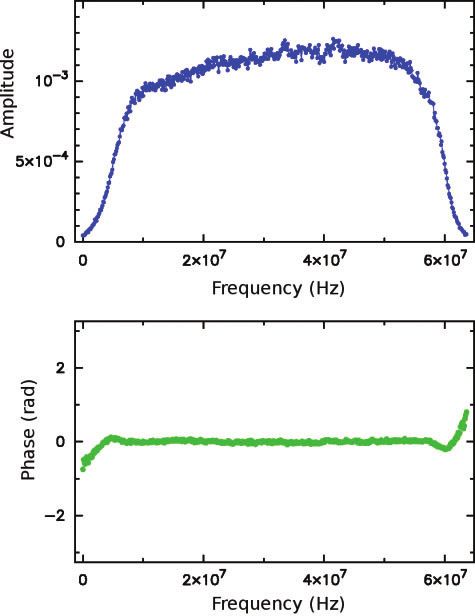
First Geodetic Observations at ASKAP-29 and WARK12M                                                                                                             111

                                              Table 4. Coordinates of ASKAP-29 and WARK12M derived from analysis of experiment vt14a

                                    Station                                                           Station coordinates (m)
                                                                           X                                       Y                                      Z
                                    ASKAP-29                    2556741.89  0.09                      5097441.23  0.14                      2847748.34  0.11
                                    WARK12M                     5115325.55  0.10                       477842.95  0.05                      3767194.41  0.09

                    cherry picker location. This provided three measurements
                    of each identified point with a fixed telescope zenith and
                    varying azimuths.
                        The resulting points from these measurements
                    describe two vertical circles of rotation which define
                    the movable elevation axis and three horizontal circles
                    of rotation which define the fixed azimuthal axis. The
                    coordinates for all subsequent calculations were retained
                    as geocentric Cartesian coordinates to avoid any possibil-
                    ity of errors related to transformation of projection.
                        The following method was used to determine the axes
                    and their intersection point from these observations. The
                    equation of a circle from three points (P. Bourke, 1990,
                    internal memo7) was used to calculate all possible com-
                    binations of three observed points which define a circle of
                    rotation. A simple mean was taken for all horizontal axis
                    definitions and all vertical axis definitions. The midpoint
                    of the closest point of approach of each axis to the other                                  Figure 3 The LBA network used in vt14a experiment.
                    was used as the final estimate of the point of intersection.
                    The distance between the closest point of approach on
                                                                                                          shown in Figure 3. Usually geodetic experiments are made
                    each axis was calculated to be 24 mm. Based on the
                                                                                                          in two bands recorded simultaneously at 2.2–2.3 GHz
                    variation of results for different combinations of survey
                                                                                                          and 8.0–8.8 GHz. Since group-delay errors are reciprocal
                    points, we estimate that the accuracy of the determined
                                                                                                          to the frequency range, a wide range, 720 MHz, is used
                    intersection point is within 0.1 m.
                                                                                                          in VLBI experiments dedicated to geodesy. Radio waves
                        In summary, the following coordinates of the inter-
                                                                                                          are delayed in the ionosphere, and the magnitude of
                    section of the azimuth and elevation axes for the radio
                                                                                                          this delay depends on total electron content along the
                    telescope WARK12M were derived in terms of ITRF2000 at
                                                                                                          paths — a highly variable quantity. Since the contribution
                    the epoch of the survey (March 2010):
                                                                                                          of the ionosphere to path delay is reciprocal to the
                                         X ¼ 5115324:5  0:1 m                                           square of effective frequency, simultaneous observations
                                                                                                          at two widely separated frequencies allow the formation
                                         Y ¼ 477843:3  0:1 m
                                                                                                          of ionosphere-free combinations of group delays.
                                         Z ¼ 3767193:0  0:1 m                                               However, for this experiment the data were recorded
                                                                                                          in the band 1368–1432 MHz in dual polarisation (i.e. a
                    It is intended that the radio telescope reference point                               single 64 MHz channel). Observations within a narrow
                    coordinates will subsequently be re-determined to a                                   band at a low frequency are highly unusual for geodetic-
                    higher accuracy with the use of a variety of terrestrial and                          style experiments since they are not able to provide
                    GNSS survey techniques Dawson, Johnston & Twilley                                     accuracy comparable with dual-frequency, wide-frequency
                    (2004) and a more rigorous least-squares analysis of                                  range experiments. However, we ran this experiment
                    the observations. Four geodetic survey monuments have                                 because in May 2010 the new antennas had only L-band
                    been built within 15–20 m of the antenna pedestal for this                            receivers, and this experiment provided an opportunity
                    purpose.                                                                              not only to make a coarse estimate of station coordinates,
                                                                                                          but also to test the equipment. The single-frequency setup
                    3 Geodetic VLBI Experiment                                                            is a limitation of the VLBI backend available at both
                    Seven stations participated in the 7-hour VLBI experi-                                ASKAP-29 and WARK12M at the time of observations.
                    ment vt14a on 2010 May 07, with the goal of determining                                   The experiment was scheduled using sur_sked soft-
                    station coordinates. The stations are listed in Table 3 and                           ware in the VLBI geodetic mode. A pool of 113 sources
                                                                                                          with correlated flux densities at X-band greater than
                    7
                     Available at http://local.wasp.uwa.edu.au/,pbourke/                                  700 mJy based on results of the ongoing LBA Calibrator
                    geometry/circlefrom3.                                                                 Survey (Petrov et al. 2011a) observing campaign was

Downloaded from https://www.cambridge.org/core. IP address: 46.4.80.155, on 27 Sep 2021 at 04:07:40, subject to the Cambridge Core terms of use, available at https://www.cambridge.org/core/terms
. https://doi.org/10.1071/AS10048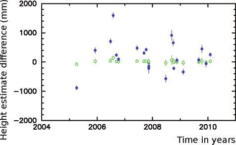
112                                                                                                                                                          L. Petrov et al.

        used. The scheduling goal was to have a uniform sky                                   noticeable correlation loss on baselines to ASKAP-29.
        coverage at each station. This was achieved by putting a                              All stations except WARK12M observed with dual circular
        next source in the schedule that has a maximum score                                  polarizations, while WARK12M observed dual linear
        among other candidate sources. The score was assigned                                 polarizations due to a malfunction of the linear-to-circular
        according to                                                                          conversion module, resulting in a p reduced
                                                                                                                                    ffiffiffi    signal-to-noise
                                                                                            ratio on WARK12M baselines: , 2 less sensitive than
                                   1 Dmin þ 0:1 4                                             expected from a priori SEFD estimates. ATCA participated
                               S ¼                                               ð1Þ
                                   ts   0:66                                                  as a phased array comprising 5  22-m dishes. Polariza-
                                                                                              tion isolation at the PARKES receiver did not work correctly
        where ts is maximum slewing time for all participating                                during the first two hours of the experiment, but this was
        antennas in seconds, and Dmin is the distance in radians                              fixed after the linear-to-circular hybrid module was reset.
        from any source observed in the past. If a source was
        observed during the previous 150 minutes, it was barred                               4.3 Post-Correlator Data Analysis
        from consideration as a candidate. Each scan had a                                    The spectrum of cross-correlation and autocorrelation for
        nominal duration of 150 s. Every hour a set of four at-                               each scan and each baseline computed by the correlator at
        mosphere calibration scans was observed: two scans with                               a uniform two-dimensional grid of accumulation periods
        all antennas with their elevation in the range [128, 458],                            and frequencies was used for further processing.
        one scan at elevations [328, 458] and one scan at elevations                             The fringe-fitting procedure searches for phase delay
        [458, 908]. The scheduling algorithm for each set found all                           tp, phase delay rate t_ p , group delay tg, and its time
        combinations of calibrator sources that fell in the eleva-                            derivative t_ g that correct their a priori values used by
        tion ranges and selected the sequence of four objects                                 the correlator model in such a way that the coherent sum
        that minimized the slewing time. The purpose of these                                 of weighted complex cross-correlation samples over a
        calibration observations was to serve as amplitude and                                given baseline and a given scan, cij,
        bandpass calibrators and to improve the robustness of                                                                XX
        estimates of the path delay in the neutral atmosphere.                                    Cðtp ; tg ; t_ p ; t_g Þ ¼    cij wij
                                                                                                                                 i      j
                                                                                                            iðo0 tp þ o0 t_ p ðti t0 Þ þ ðoj o0 Þtg þ ðoj o0 Þ_tg ðti t0 ÞÞ
        4 Data Analysis                                                                                e                                                                         ð2Þ
        4.1 Data Transfer and Correlation
                                                                                              reaches the maximum amplitude. Index i runs over time
        Following the observations, the data from ATCAPN5,                                    and index j runs over frequencies. v0 and t0 denote the
        HOBART26, MOPRA and PARKES were transferred via fast                                  angular reference frequency within the band and the ref-
        network connections to a petabyte data store operated by                              erence time within a scan and wij are weights that are
        iVEC in Western Australia, with the support of ARCS                                   defined as a fraction of processed samples in each accu-
        (the Australian Research Collaboration Service). The data                             mulation period. The software PIMA was used for ampli-
        from WARK12M were transferred from the telescope using                                tude calibration and evaluation of phase and group delay,
        the trans-Tasman link directly to Perth. The data from                                as well as their time derivatives. The algorithm imple-
        ASKAP-29 were transported to Perth by car, as the fast                                mented in PIMA is described in detail in Petrov et al.
        network to the MRO at the time of the experiment was                                  (2011b).
        under construction. All data were later transferred to disks                             After computing phase and group delays and their
        mounted on the correlation cluster at Curtin University                               derivatives, the spectrum of cross-correlations can be
        and correlated using the DiFX software correlator (Deller                             averaged over time or frequency. This provides valuable
        et al. 2007). Initial antenna positions for WARK12M and                               diagnostics. The amplitude spectrum at the new stations
        ASKAP-29 determined from GPS receivers were used for                                  ASKAP-29 and WARK12M shows a significant drop of
        correlation. Other station positions are known from VLBI                              the amplitude near the edges of the band as it is seen in
        solutions with accuracy better than one centimeter (Petrov                            Figure 4. The signal-to-noise ratio losses due to the shape
        et al. 2009a). The data were correlated using an integra-                             of the filter are at a level of 13%. A portion of the band
        tion period of 0.25 s and 512 frequency channels across                               with the fringe amplitude less than one quarter of the
        the 64-MHz band. All four combinations of right and left                              maximum was filtered out in the final processing.
        circular polarization signals were correlated.                                           Since the observations were made during low solar
                                                                                              activity, the ionosphere did not cause significant decorr-
        4.2 Data Quality Control Made at the Correlator                                       elation. Instability of the rubidium frequency standard is
        Initial data-quality checking and clock searching was                                 clearly seen in Figure 5, and it caused a decorrelation on
        performed at the correlator using an automated pipeline                               baselines with ASKAP-29 at a level of 4–5%.
        script implemented using the ParselTongue AIPS inter-                                    At the first step of geodetic data analysis, the spec-
        face (Kettenis et al. 2006). Hydrogen masers were used                                trum of the cross-correlation function was screened.
        to provide the frequency standard at all stations except                              The edges of the bandpass and several spurious peaks
        at ASKAP-29 where a lower-stability (but still acceptable)                            near the center of the bandpass were filtered out. The
        rubidium frequency standard was used. This resulted in a                              complex bandpasses were evaluated and the fringe-fitting

Downloaded from https://www.cambridge.org/core. IP address: 46.4.80.155, on 27 Sep 2021 at 04:07:40, subject to the Cambridge Core terms of use, available at https://www.cambridge.org/core/terms
. https://doi.org/10.1071/AS10048
First Geodetic Observations at ASKAP-29 and WARK12M 113
Figure 4 The amplitude (upper plot) and phase (lower plot) of the
cross-correlation spectrum in a scan of source 0537–441 at baseline Figure 5 The phase of the cross-correlation spectrum in a scan
ASKAP-29/PARKES averaged over time after applying fringe search. of source 0537–441 at baseline WARK12M/PARKES (upper plot)
Integration time 0.25 s. and ASKAP-29/PARKES (lower plot) averaged over frequency after
applying fringe search solutions.
procedure was repeated with the the refined bandpasses
Jacobs (1998) with some refinements. The most signifi-
and with the bandpass mask applied. This procedure is
cant ones are the following. The advanced expression for
described in full detail in Petrov et al. (2011b). Analysis
time delay derived by Kopeikin & Schäfer (1999) in the
of the amplitudes at all combinations of right and left
framework of general relativity was used. The displace-
circular polarizations, RR, LL, LR and RL, confirmed that
ments caused by the Earth’s tides were computed using
the polarization setup at PARKES for the first two hours was
the numerical values of the generalized Love numbers
qffiffiffiffiffiffiffiffiffiffiffiffiffiffiffiffiffiffiffiffiffiffiffiffiffiffiffiffi
incorrect. But it was also foundq ffiffiffiffiffiffiffiffiffiffiffiffiffiffiffiffiffiffiffiffiffiffiffiffiffiffiffiffi
that polarization impurity, presented by Mathews (2001) following a rigorous algo-
defined as jRLj þ jLRj = jRRj2 þ jLLj2 , was sig-
2 2
rithm described by Petrov & Ma (2003) with a truncation
nificant on baselines with other stations. For example, the at a level of 0.05 mm. The displacements caused by ocean
polarization impurity at baseline ATCAPN5/MOPRA was at a loading were computed by convolving the Green’s func-
level 7%, on baselines ATCAPN5/HOBART26, ATCAPN5/ tions with ocean tide models. The GOT99.2 model of
ASKAP-29 and ATCAPN5/PARKES was 25–30%, and the base- diurnal and semi-diurnal ocean tides (Ray 1999), the
line ATCAPN5/WARK12M was ,100%. Therefore, the NAO99 model (Matsumoto, Takanezawa & Ooe 2000)
coherent combining dual polarization improved the sig- of ocean zonal tides, the equilibrium model (Petrov & Ma
nal-to-noise ratio at some baselines and degraded it at 2003) of the pole tide, and the tide with period of 18.6
others. For this reason, the datasets of group delays with years were used. Station displacements caused by the
RR and LL polarizations were used as independent atmospheric pressure loading were computed by convolv-
experiments in further processing. ing the Green’s functions that describe the elastic proper-
The next step of the analysis pipeline is to compute ties of the Earth (Farrell 1972) with the output of the
theoretical path delays and form small differences atmosphere NCEP Reanalysis numerical model (Kalnay
between them and derived group delays. Computation et al. 1996). The algorithm of computations is described
of theoretical path delays was made with the use of the VTD in full detail in Petrov & Boy (2004). The displacements
software8 that incorporates state-of-the art geophysical due to loading caused by variations in soil moisture and
models. Our computation of theoretical time delays in snow cover in accordance with the GLDAS Noah model
general follows the approach of Sovers, Fanselow & (Rodell 2004) with a resolution 0.258 0.258 were com-
puted using the same technique as the atmospheric pres-
8
http://astrogeo.org/vtd. sure loading. The empirical model of harmonic variations
Downloaded from https://www.cambridge.org/core. IP address: 46.4.80.155, on 27 Sep 2021 at 04:07:40, subject to the Cambridge Core terms of use, available at https://www.cambridge.org/core/terms
. https://doi.org/10.1071/AS10048114 L. Petrov et al.
in the Earth orientation parameters heo_20101111 electron content (TEC) from GPS using the data product
derived from VLBI observations according to the method from the analysis center CODE did not improve the fit
proposed by Petrov (2007) was used. The time series of and shifted estimates of station coordinates at a fraction
UT1 and polar motion derived by the NASA Goddard of the formal uncertainty (0.2s). Analysis of dual-band
Space Flight Center operational VLBI solutions were VLBI experiments showed that global TEC maps above
used a priori. Australia and New Zealand provided by the International
The a priori path delays in the neutral atmosphere in Global Navigation Satellite System Service are not reli-
the direction of observed sources were computed by able, and the path delay computed from this model poorly
numerical integration of differential equations of wave represents the true delay in the ionosphere, at least during
propagation through the heterogeneous media. The four- solar minimum (Petrov et al. 2011a).
dimensional field of the refractivity index distribution The adjustments to the residual zenith path delay in the
was computed using the atmospheric pressure, air tem- atmosphere were in the range of 1–5 ns, while they are
perature and specific humidity taken from the output typically in the range 0.03–0.1 ns for dual-band observa-
of the Modern Era Retrospective-analysis for Research tions. Unlike the estimation of the mismodeled tropo-
and Applications (MERRA) (Schubert et al. 2008). That sphere path delay, estimation of unmodeled ionosphere
model presents the atmospheric parameters on a grid path delay in the zenith direction from the observations
1/28 2/38 6h at 72 pressure levels. themselves does not adequately represent the true path
In the initial least square (LSQ) solution, positions delay, since when antennas point in different directions,
of all stations except PARKES were estimated, as well as the ionosphere-piercing points with a typical height of
coefficients of the expansion of clock function and the ,450 km may be located at distances of up to 1000 km.
residual atmosphere path delay in the zenith direction into For evaluation of the robustness of our coordinate
the B-spline basis of the first degree. The quality check estimates we made a trial solution and estimated the
revealed a clock break at station HOBART26. During the position of station ATCAPN5 independently. Estimates of
preliminary phase of the data analysis, outliers were the position of ATCAPN5 appeared within 2s of the CATN5
eliminated and the baseline-dependent corrections to pad. The position of CATN5 was derived from the
the a priori weights, defined to be reciprocal to formal position of the pad CATW104 determined from previous
uncertainties of group delays, were determined in such a VLBI observations and from the results of a local survey
way that the ratio of the weighted sum of squares of that measured coordinates of CATN5 with respect of
residuals to their mathematical expectation was close to CATW104 (Petrov et al. 2009a). This gave us a hint that
unity. Group delays from RR and LL polarization data the reported uncertainty may be underestimated by a
were processed independently. factor of 2, especially for the vertical component. In our
The final LSQ solution used all VLBI group delays final solution we applied the eccentricity vector between
collected from 1984 through 2010,9 a total of 7.5 million CATN5 and CATW104 from the local survey.
values, including 824 group delays from this experiment. The data from RR and LL polarizations have indepen-
Positions of all stations, all sources, the Earth orientation dent random errors, but they share the same systematic
parameters and over 1 million nuisance parameters were errors. In another trial solution we processed RR and LL
estimated in a single LSQ run. Minimal constraints were data separately. The position differences of these two
imposed to require that net translation and net rotation solutions were within 1s for the horizontal component
over new position estimates of 48 stations with long and 2s, or 0.4 m, for the vertical component.
histories with respect to positions of observations to these However, the latter test is not sensitive to common
stations in the ITRF2000 catalogue (Altamimi, Sillard & systematic errors caused by unmodeled ionosphere path
Boucher 2002) to be zero. This ensures that positions of delays. In order to evaluate the magnitude of the iono-
all stations, including ASKAP-29 and WARK12M, are consis- sphere path delay errors, we used prior observations at the
tent with the ITRF2000 catalogue. More details about baseline PARKES/HOBART26 under the IVS geodetic pro-
theparameter estimation technique can be found in Petrov gram. We selected twenty-one 24-hour experiments in
et al. (2009b). 2005–2010, the period of solar minimum. We ran three
The estimates of coordinates of ASKAP-29 and WARK12M sets of 21 trial solutions. Within each set we used all
on epoch 2010.05.07 are given in table 4. The errors experiments from 1980 through 2010 with station
reported in the table are the formal uncertainties from the HOBART26 removed from all but one experiment. The only
LSQ solution computed in accordance with the error experiment with HOBART26 was different in each solution
propagation law. Since there was only one experiment within a set. In such an experiment all other stations except
available with rather an unusual setup, it is difficult to HOBART26 and PARKES were removed. This setup emulated
provide a realistic estimate of errors. the case of determining station coordinates from one
The largest source of systematic error is the path delay experiment only. The reference set A used an iono-
in the ionosphere. Our attempt to use maps of the total sphere-free combination of X- and S-band group delays.
The set B used X-band group delays for an experiment
9
Available at the IVS Data Center at http://ivscc.gsfc.nasa. with HOBART26 and X/S combinations for all other experi-
gov/products-data/index.html. ments. The set C used S-band group delays. We obtained
Downloaded from https://www.cambridge.org/core. IP address: 46.4.80.155, on 27 Sep 2021 at 04:07:40, subject to the Cambridge Core terms of use, available at https://www.cambridge.org/core/terms
. https://doi.org/10.1071/AS10048First Geodetic Observations at ASKAP-29 and WARK12M 115
VLBI observations. The random position 1s errors, 5–
6 cm for the horizontal coordinates and 20–40 cm for the
vertical component, are close to that what one can expect
from narrow-band observations at L band. It is a pleasant
surprise that the very first observations that followed the
successful fringe test yielded a reasonable result. How-
ever, the systematic errors due to unaccounted ionosphere
are significantly greater: 1.3 m for the vertical component
and 0.14 m for the horizontal component. We also iden-
tified several problems with station equipment that will
be fixed in the future. The use of a rubidium frequency
standard at ASKAP-29 caused a decorrelation at a level of
Figure 6 The differences in the vertical coordinate estimate of 4–5% within 2-minute long scans. The frequency insta-
station HOBART26 from a series of trial solutions, when position was bility at longer time intervals appeared negligible with
estimated only from one experiment at a single baseline with PARKES. respect to errors caused by the ionosphere.
Hollow circles represent the difference between the X-band-only The existing L-band (1.4-GHz) receiver on ASKAP-29
solution and the X/S dual-band solution. The weighted root mean
will be replaced in early 2011 with a new receiver
square (wrms) is 40 mm. Filled discs represent the difference
between the S-band-only solution and the X/S dual-band solution. comprising a purpose-built feed horn optimized for this
The wrms is 490 mm. antenna, with significantly higher efficiency, and a noise
calibration source. In 2011 ASKAP-29 may be equipped
with an X-band (8.4-GHz) receiver, and the possibility
of an upgrade to a higher frequency receiver is being
three series of 21 estimates of HOBART26 positions. We considered.
formed the difference between estimates of HOBART26Ś In 2011, WARK12M was equipped with S/X dual-band
vertical and horizontal coordinates between sets B and A, receivers. Future geodetic experiments at these frequen-
and between sets C and A. The differences for the vertical cies are planned for February 2011. The participation
component of site position estimates are given in Figure 6. of stations ASKAP-29 and WARK12M in VLBI experiments
The only difference between the solutions in sets A, under absolute astrometry and geodesy programs will
B, and C is the treatment of the ionosphere path delay. permit an improvement in the precision of results by
Therefore, we can consider the differences B A and two orders of magnitude and reach a millimeter level
C A to be primarily due to the contribution of unmodeled of accuracy. A more precise survey to provide 1–3 mm
ionosphere path delay to estimates of site position. The accuracy of the tie vector between VLBI and GPS antenna
average ratio of differences (B A)/(C A) is 13.7 which reference points is planned. By combining this with
is very close to the square of the ratio of effective iono- further VLBI observations it will be possible to reconcile
sphere frequencies at X and S bands: (8.387/2.250)2 E the currently observed differences between GPS and VLBI
13.9. This supports our argument that the differences positions of the WARK12M antenna reference point.
C A are due to the ionosphere path delay at S band. In November 2010, Telecom New Zealand made its
Since the differences B A and C A are nicely scaled 30-metre satellite Earth station available to AUT’s Insti-
with the square of effective frequency, we can extrapolate tute for Radio Astronomy and Space Research. It is a
the estimates of the weighted root mean square (wrms) of wheel-and-track beam-waveguide antenna built by NEC
site-position time series from solution C to the L band by Corporation in 1984. It will be converted to a radio
scaling them by (2.250/1.4)2 E 2.6. If we were determin- telescope capable of conducting both astronomical and
ing the position of HOBART26 from one of these twenty-four geodetic research.
experiments at L band, the wrms of position errors due to
unaccounted ionosphere path delay would have been 1.3 m
for the vertical component and 0.14 m for the horizontal Acknowledgments
component. We extrapolate these numbers to our estimates This work uses data obtained from the MRO, jointly
of ASKAP-29 and WARK12M positions. funded by the Commonwealth Government of Australia
The differences in position estimates of WARK12M from and the Western Australian State government. The MRO
VLBI and from GPS surveys, VLBI GPS, are 1.66 m for is managed by the CSIRO. We acknowledge the Wajarri
the vertical component, 0.49 m for the east component, Yamatji people as the traditional owners of the Obser-
and 0.48 m for the north component. The difference in vatory site. The Long Baseline Array is part of the Aus-
the vertical component can be explained by the effect of tralia Telescope National Facility which is funded by the
the ionosphere. Commonwealth of Australia for operation as a National
Facility managed by CSIRO. The International Centre for
5 Summary and Future Work Radio Astronomy Research is a Joint Venture of Curtin
We obtained the first estimates of the positions of University and The University of Western Australia,
ASKAP-29 and WARK12M antenna reference points from funded by the Western Australian State government.
Downloaded from https://www.cambridge.org/core. IP address: 46.4.80.155, on 27 Sep 2021 at 04:07:40, subject to the Cambridge Core terms of use, available at https://www.cambridge.org/core/terms
. https://doi.org/10.1071/AS10048116 L. Petrov et al.
iVEC is a joint venture between CSIRO, Curtin Univer- Johnston, S. et al., 2008, ExA, 22(3), 151
sity, Edith Cowan University, The University of Western Kalnay, E. M. et al., 1996, Bull. Amer. Meteorol. Soc., 77, 437–471
Australia and Murdoch University and is supported by Kettenis, M., van Langevelde, H. J., Reynolds, C. & Cotton, B.,
2006, Astron. Data Anal. Software Syst. XV, 351, 497
the Western Australian Government. SJT is a Western Kopeikin, S. M. & Schäfer, G., 1999, Phys Rev D, 60(12),
Australian Premier’s Research Fellow, funded by the 124002
Western Australian government. This project was sup- Mathews, P. M., 2001, J Geod Soc Japan, 47(1), 231
ported in part by the Australian Research Collaboration Matsumoto, K., Takanezawa, T. & Ooe, M., 2000, J Oceanography,
Service (ARCS). We used in our work the dataset 56, 567
Petrov, L., 2007, A&A, 467(1), 359
MAI6NPANA provided by the NASA/Global Modeling Petrov, L. & Ma, C., 2003, JGR, 108(B4), 2190
and Assimilation Office (GMAO) in the framework of the Petrov, L. & Boy, J.-P., 2004, JGR, 109, B03405
MERRA atmospheric reanalysis project. Petrov, L., Phillips, C., Bertarini, A., Deller, A., Pogrebenko, S. &
Mujunen, A., 2009a, PASA, 26, 75
References Petrov, L., Gordon, D., Gipson, J., MacMillan, D., Ma, C., Foma-
lont, E., Walker, R. C. & Carabajal, C., 2009b, J. Geodesy, 83(9),
Alexander, F. E. S., 1946, Radio & Electronics, 1(1), 16–17, 20 859
Altamimi, Z., Sillard, P. & Boucher, C., 2002, JGR, 107, 2214 Petrov, L., Phillips, C., Bertarini, A., Murphy T. & Sadler E. M.,
Blick, G. & Collett, D., 2010, Survey Quarterly, 63, 20 2011a, MNRAS, in press, preprint (astro-ph/1012.2607)
Bolton, J. G., Stanley, G. J. & Slee, O. B., 1949, Natur, 164(4159), Petrov, L., Kovalev, Y. Y., Fomalont, E., Gordon, D., 2011b, AJ,
101 submitted, preprint (astro-ph/1101.1460)
Bolton, J. G., 1982, in Proceed. Astronom. Soc. Austr. 4(4), 349 Ray, R. D., 1999, NASA/TM-1999-209478, Greenbelt, MD USA
Charlot, P. et al., 2002, in the 6th EVLBI Network Symposium, 9 Rodell, M. et al., 2004, Bull. Amer. Meteor. Soc., 85(3), 381
http://mpifr-bonn.mpg.de/div/vlbi/evn2002/ Sarti, P., Sillard, P. & Vittuari, L., 2004, J Geodesy, 78(3), 210
bookPCharlot.pdf Sarti, P., Abbondanza, C. & Vittuari, L., 2009, J Geodesy, 83(11),
Collett, D., 2010, in Proceeding of FIG Congress ‘Developing a 1115
National Real-time CORS Network in New Zealand’ http:// Schubert S. et al., 2008, In Proc. of Third WCRP International
www.linz.govt.nz/geodetic/standards-publi Conference on Reanalysis, Tokyo, V1–104 (http://wcrp.
cations/published-paper-presentations/col ipsl.jussieu.fr/Workshops/Reanalysis2008/
lett-national-real-time-cors-network.pdf Documents/V1-104_ea.pdf)
Dawson, J., Johnston, G. & Twilley, B., 2004, in Proceedings of the Smits, R., Tingay, S. J., Wex, N., Kramer, M. & Stappers, B., 2010,
IERS Workshop in site co-location, IERS Technical Note, A&A, submitted
No 33. 128 Sovers, O. J., Fanselow, J. L. & Jacobs, C. S., 1998, Rev Modern
Deller, A. T., Tingay, S. J., Bailes, M. & West, C., 2007, pasp, 119, 318 Phys, 70, 1393
Farrell, W. E., 1972, Rev. Geophys. Spac. Phys., 10(3), 751 Tingay, S. J. et al., 2006, ATNF Newsletter, 58, 8–10 http://
Gulyaev, S., Natusch, T., Addis, B., Tingay, S. & Deller, A., 2005, www.atnf.csiro.au/news/newsletter/feb06/ATNF
Southern Stars, 44(4), 12 news_06Feb.pdf
Gulyaev, S. & Natusch,T., 2009, In International VLBI Service for Tzioumis, A. K. et al., 2010, AJ, 140(5), 1506
Geodesy and Astrometry 2008 Annual Report, NASA/TP–2009- Weston, S., Natusch, T., Gulyaev, S., 2010, in Procedings of the 17th
214183, Eds. Behrend, D. & Baver, K. D., 68 ftp://ivscc. Electronics New Zealand Conference, submitted (preprint astro-
gsfc.nasa.gov/pub/annual-report/2009/pdf/ ph/1011.0227)
nswark.pdf
Downloaded from https://www.cambridge.org/core. IP address: 46.4.80.155, on 27 Sep 2021 at 04:07:40, subject to the Cambridge Core terms of use, available at https://www.cambridge.org/core/terms
. https://doi.org/10.1071/AS10048You can also read