ExactAIS GEOSPATIAL WEB SERVICES - TECHNOLOGY WHITE PAPER
←
→
Page content transcription
If your browser does not render page correctly, please read the page content below

exactAIS GEOSPATIAL
WEB SERVICES™
TECHNOLOGY WHITE PAPER

                         +1 519 622 4445   |   exactearth.com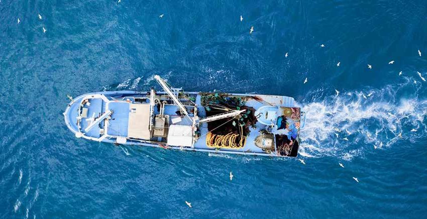
EXECUTIVE SUMMARY
exactEarth Ltd (www.exactearth.com) is a private data services company delivering near-real time (NRT), global
location-based maritime vessel tracking information for government authorities and a wide range of commercial
organisations, through its exactAIS® tracking service.

exactAIS Geospatial Web Services™ allows users to easily access and integrate NRT ship information into existing Open
Geospatial Consortium (OGC)-compliant geospatial platforms such as ESRI and Google Earth.

BACKGROUND                                                                                 BEING ABLE
There is no disputing that the world’s waters are busy. On any given day, they
                                                                                           TO TRACK,
support the weight of thousands of small boats, container ships, passenger                 MONITOR AND
liners, tankers and cargo ships, providing vital, fluid transit corridors that rival the   ANALYZE VESSEL
busiest road networks.
                                                                                           MOVEMENTS WITH
And in the commercial trade arena, the oceans are unrivaled – according to the             CONFIDENCE
International Maritime Organization (IMO), more than 90 percent of global trade            REQUIRES
is carried by sea, and the amount of cargo transported by sea reached 8.4 billion          ACCURATE,
tons in 2010. Shipping is indeed the anchor of the global economy, without
which, the majority of the world’s stores would be empty.
                                                                                           TRUSTED DATA ON
                                                                                           WHICH TO BASE
However, all of this vessel traffic against the backdrop of the vast, open water,          THE BEST POSSIBLE
presents sizable navigation, monitoring and tracking challenges. Knowing who
is on the water at any given time and where they are headed is essential to
                                                                                           DECISIONS.
maritime safety, yet it is one of the most challenging questions to answer with
certainty.

That critical situational awareness – the who, where and when on the water – is what exactEarth’s exactAIS information
provides. An information anchor for the marine environment, exactAIS receives and delivers in near-real time global
AIS messages to customers via a secure internet link, providing an unparalleled, global view of the recognised maritime
picture at any given time, for any given area of ocean. And it’s been providing this complete maritime landscape through
its own constellation of micro satellites since 2009, helping vessels safely reach shore, enhancing security, safeguarding
the environment and even helping to save lives.

However, as much as this data has buoyed safe navigation and authorities’ maritime domain awareness, the detail of
those AIS messages, their frequency and their formats have presented data management and interoperability challenges
for customers. In particular, the specialised, text-based nature of the satellite AIS data has made it difficult for users
to easily share and integrate this NRT data with other GIS and geospatial tools. That lack of data interoperability has
moored the inherent value of AIS data to the confines of these specialised information systems, inhibiting users’ abilities
to leverage this maritime intelligence to plot new innovations, make useful connections and make more informed
business decisions.

                                                               PAGE 2                      +1 519 622 4445   |   exactearth.com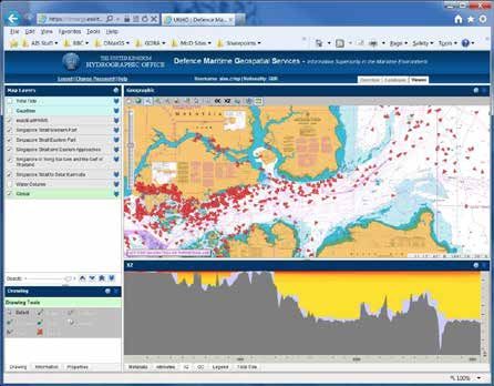
AIS GEOSPATIAL WEB SERVICES
To transform its satellite AIS data into an integral and actionable beacon of marine intelligence, exactEarth created
exactAIS Geospatial Web Services (GWS), a customisable, on-demand data distribution model that allows users to easily
access and integrate NRT ship information into existing OGC compliant geospatial platforms such as ESRI and Google
Earth.

An OGC-certified solution, GWS synthesise and transform text-based AIS messages into spatial-ready, ship-centric
information. Functioning like a vessel information drive-thru, users access the GWS through their existing geospatial
platform, choose specific datasets on offer, such as the latest vessel information, historical track information, or ship
density maps, and GWS then delivers the files for immediate consumption. As GWS are supported with OGC filtering,
customers can also dynamically customise the data based on geography, time and AIS message attributes, ensuring they
only receive the exact vessel-voyage data they need.

While Satellite AIS (S-AIS) data provides key ship details such as position, course and speed, an important distinction of
GWS is that they combine the near-real time, individual messages received for a vessel and automatically convert them
into a geospatial, vessel-centric model of individual ship movements over time. Those visual and temporal tracks can
then be viewed on a map or retrieved on demand. It is targeted exactAIS data how and when users want it, without the
need for sophisticated databases and maritime analytical systems.

Indeed, exactEarth is setting a significant new data course direction with GWS to deliver S-AIS based information that is
as dynamic and fluid as the marine environment, which will ultimately allow customers to better see the ebb and flow of
maritime-vessel activity in the area of the world that matters to them.

ALL ABOUT THE OPEN GEOSPATIAL CONSORTIUM
The Open Geospatial Consortium (OGC) is an international industry consortium of 482
companies, government agencies and universities participating in a consensus process
to develop publicly available interface standards. OGC Standards support interoperable
solutions that “geo-enable” the web, wireless and location-based services and mainstream
IT. The standards empower technology developers to make complex spatial information
and services accessible and useful with all kinds of applications.

The OGC holds a vision to achieve the full societal, economic and scientific benefits of
integrating location resources into commercial and institutional processes worldwide by
advancing the development of international standards for geospatial interoperability.

                                                           PAGE 3                    +1 519 622 4445     |   exactearth.com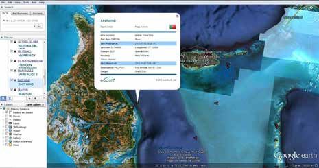
KEY FEATURES
As an OGC-compliant solution, GWS
now make exactAIS data compatible
with the desktop, enabling clients to
overcome the data interoperability riddles
and integration traps that can foil their
attempts to fully share and exploit their
trove of maritime-vessel intelligence.
GWS are out-of-the-box compatible
with Esri software, including ArcMap,
ArcGlobe, and many more. In addition, an
ArcMap 10.1 add-in enables users to take full advantage of GWS, by providing an easy-to-use interface to add and create
filters, as well as identify and generate historical tracks, making the integration of exactAIS data even easier. Using a set
of drop-down menus, users can choose how to style, colour, and filter the GWS LVI layer and add it to the map.
The add-in also includes a built-in tool to identify GWS information. Using the “exactAIS GWS GetFeatureInfo” tool, users
can click on any vessel or historical track to display its name, position, and destination information.
• G WS provide OGC-compliant Web Map Services and Web Feature Services to retrieve vessel position, static,
voyage, and historical track information.
• G WS support OGC filtering to allow for dynamic/ad-hoc customisation of data responses based on geography,
time, and AIS-message attributes.
• G WS support all OGC WMS operations from implementation WMS 1.1.1 and WMS 1.3.0 (compliant) and all OGC
WFS operations from implementations WFS 1.0.0 and WFS 1.1.0 (compliant), excluding transaction.
• GWS is fully compatible with Google Earth and KML as well as many other GIS viewers/tools and web mash ups.
PAGE 4 +1 519 622 4445 | exactearth.com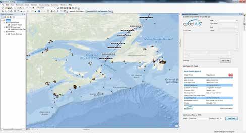
BENEFITS
The ability to readily know the who, what and when of any transiting vessel is a critical piece of intelligence and
a boon to any marine operation – knowledge that exactAIS provides. With GWS, the maritime picture becomes
even brighter. Transforming that highly valuable exactAIS information into OGC-compliant spatial layers enables
customers to readily share and distribute a comprehensive maritime picture across their organisations, deepening
their understanding of ship activity and improving decision-making.
GWS allow customers to access data “on-demand,” enabling them to pull out the information they want, when they
want it. Designed to simplify data access and content, while improving usability, GWS give users the chance to
experience exactAIS data on their own terms – they pilot the vessel data.
GWS eliminate the need to understand or deal with the complexities of S-AIS messages because they transform
them into easy-to-digest, vessel-centric data.
Customers need only their own geospatial platform to access and retrieve data through the GWS – exactEarth
hosts the data on its own dedicated server. Additionally, the interoperability feature of GWS allow users to instantly
gain access to data without costly or time consuming re-training of staff or new custom programming as the GWS
are compatible with many of the GIS platforms currently available.
• OGC-certified delivery of maritime vessel information, derived from the latest S-AIS messages.
• Provides the ability to seamlessly integrate exactAIS with existing geospatial platforms with little to no time
or effort.
• Removes the complexity of processing S-AIS messages.
• Provides the ability to create custom data views using filters.
• Improves efficiency: instead of spending money (and time) setting up and managing AIS database
environments, exactEarth can host the data and serve you on demand.
• Customers receive the data they want, when they want it – and only pay for what they receive.
THE SCOOP ON WEB SERVICES
Web services are software components that are accessible across the Internet. In simple terms, a web service is
passed a request, question or a task and responds to the input by returning the appropriate data for the answer.
Web services are reusable and can be made openly available for interactive use, or can support calls to them that
can be embedded inside software applications and website pages. When an application or website incorporates a
particular service, the service activates and responds when called upon. For example, a web service could return a
weather forecast, an insurance quote or current stock exchange information. Specific to exactAIS Geospatial Web
Services, when location (geospatial) data is involved, the GWS can return data in the form of a map.
Access to both a web service registry and the services themselves can be protected so that only authenticated
users may locate and use web services. This is achieved with GWS by issuing to an authorised user a “Token” (or
unique identifier) that they then use in all communications with the GWS.
PAGE 5 +1 519 622 4445 | exactearth.comGWS IN ACTION
With this new vessel-centric view of the maritime world, users across the varied marine-related landscape can
now capitalise on the intrinsic value of exactAIS information as they navigate the daily business of defence and
intelligence, shipping, hydrographic surveying and environmental monitoring.
1) ENVITIA AND THE UNITED KINGDOM HYDROGRAPHIC OFFICE
The United Kingdom Hydrographic Office (UKHO) have a large amount of information available for its military
customers. However it is not readily available at short notice, nor is information pertaining to the extent and
content of such data. The rapid and dynamic nature of today’s operations along with the availability of the
Internet and military network infrastructure, have raised expectations on the availability of information and
timescales for delivery. Working with Envitia and exactEarth, the UKHO has been developing a web-based
Discovery, Evaluate, Present and Delivery capability for all their defence focused products.
To meet the demands of the defence community, UKHO required a sophisticated and integrated capability that
provides access to all defence Maritime Geospatial Information through a simple, intuitive portal interface. This
has lead to the development of the Defence
Maritime Geospatial Services (DMarGS)
capability.
The portal interface allows the user to search
and select an area of interest using a gazetteer
or map view. They can then search and discover
what data and products are available, preview
selected data and query as to suitability and
finally download or dispatch that data ready
for exploitation either by human or deployed
systems. DMarGS delivers a collection of web
services based upon the Open Geospatial
Consortium (OGC) standards, which are open
and extensible.
This project has shown that it is possible to
deliver the enhanced agile integrated services
demanded by the modern defence user, both
through a human-consumable portal and via
direct web services into deployed systems using
open standards. Collaboration with exactEarth GWS, enables users to see an
integrated Situation Awareness Picture in the browser.
PAGE 6 +1 519 622 4445 | exactearth.comGWS SETS A NEW COURSE
As the world’s waters continue to support the weight of the global economy, the ability of exactAIS to bring the vastness
of maritime activity down to manageable size is essential. Even more beneficial is to provide that NRT intelligence in a
customised, GIS-ready dataset that can be immediately shared and integrated into users’ information systems.
exactEarth’s GWS offer such integrable and actionable vessel-centric views of the maritime world. With GWS, users
across the varied marine-related landscape can now capitalise on the intrinsic value of exactAIS information as
they navigate their own unique daily business, be it defence and intelligence, shipping, hydrographic surveying or
environmental monitoring.
After all, vessel information should be as dynamic and fluid as the marine environment.
PAGE 7 +1 519 622 4445 | exactearth.comFounded in 2009, exactEarth was established for the purpose of making Satellite AIS data services available
to the global maritime market. Based in Cambridge, Ontario, Canada, exactEarth leverages advanced satellite
technology to deliver vessel monitoring solutions characterized by high performance, reliability, security,
and simplicity. exactEarth is a leading organization in the field of global Automatic Identification System
vessel tracking, collecting the most comprehensive ship monitoring data and delivering the highest quality
information to customers around the world.
exactEarth Ltd. exactEarth Europe
260 Holiday Inn Drive Satellite Applications Catapult
Unit 30, Building B Electron Building, Fermi Avenue
Cambridge, Ontario Harwell (Didcot)
N3C 4E8 Oxfordshire, OX11 0QR
United Kingdom
+1 519 622 4445 +44 (0)7500 935091
©2021 exactEarth Ltd. All rights reserved.
PAGE 8 +1 519 622 4445 | exactearth.comYou can also read