Elephant Corridor loss due to anthropogenic stress - a study of change in forest cover using satellite data in the Sonitpur District, Assam, India
←
→
Page content transcription
If your browser does not render page correctly, please read the page content below
1 | Journal of Wildlife and Biodiversity 6(X): X-X (2022)

Volume 6 (x): x-x (2022) (http://www.wildlife-biodiversity.com/)
                                                                                                                     Scientific Report

Elephant Corridor loss due to anthropogenic stress – a study of
change in forest cover using satellite data in the Sonitpur
District, Assam, India
Himika Deb1, Aloke Saha2, Sachin Deore1, Tanmay Sanyal3*
1
 Department of Geography, SNDT Women’s University, Pune, Maharashtra 411038, India
2
 Department of Zoology, University of Kalyani, Kalyani, Nadia, West Bengal 741235, India
3
 Department of Zoology, Krishnagar Govt. College, Krishnagar, Nadia, West Bengal, 741101, India
Email: tanmaysanyalzool@gmail.com
Received: 03 May 2022 / Revised: 07 June 2022 / Accepted: 07 June 2022/ Published online: 07 June 2022. Ministry of Sciences,
Research, and Technology, Arak University, Iran.
How to cite: Deb, H., Saha, A., Deore, S., Sanyal, S. (2022). Anthropogenic stress and its impacts on the Elephant habitat corridors, A case
with Sonitpur district, Assam, India, Journal of Wildlife and Biodiversity, 6(x), x-x. DOI: https://doi.org/10.5281/zenodo.6627395

Abstract
Elephant habitats were mainly found in the dense forest regions which is the tropical evergreen
forest in Sonitpur District, Assam. The total area of Sonitpur District is approximately 5204 km2.
Satellite imagery of 1990, 2009, and 2017 was investigated. The current research aims to
investigate the huge amount of deforestation that occurred from 1990 to 2017 in the Sonitpur
district using a temporal satellite imagery system. The visual data interpretation and change
matrix analysis using three-period imagery indicated significant corridor loss and deforestation
between 1990 and 2017. The study indicates that a massive number of land-use changes would
be occurring within the next few years. So, to protect elephants and forests, agricultural land
should be converted into natural forests and anthropogenic activities should be stopped in the
corridors and buffer areas. Local communities and government should take various steps to do
so and Government should take legal steps against elephant killing. This research focuses on the
conservation problems associated with the corridor's decrease over time. The findings also
indicated the advanced capabilities of GIS and remote sensing for monitoring and analyzing
corridor status.
Keywords: Elephant corridor, Sonitpur, GIS, Remote sensing, Wildlife

Introduction
India is the home to more than 50% of all Asian Elephant population, and as per the 2017
elephant census, India has 27,312 elephants, a 10% decline from the 2012 census, when the
country had 30,000 elephants (Aggarwal, 2017). In 2018, the supreme court has given a historic
judgment in response to public interest litigation. For violating the legislation, Justice Lokur, S.
Abdul Nazeer, and Deepak Gupta asked the Tamilnadu government to halt the development of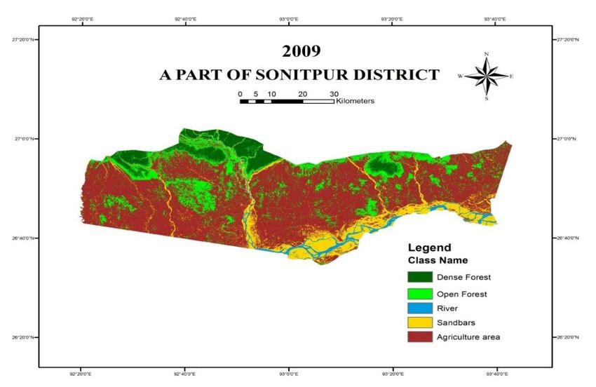
2 | Journal of Wildlife and Biodiversity 6(X): X-X (2022)

39 hotels and resorts along an elephant corridor in the Nilgiri hills. In their judgment they
described India’s elephants as a “Keystone species (Sundararaju, 2018). The MoEFCC described
the elephant as the National Heritage Animal of India” (Sundararaju, 2018).
Elephant Corridors play a vital role to maintain population viability in a broader landscape.
Elephant corridors are being destructed gradually due to increased settlement, cultivation, and
developmental activities of the human population (Sarma et al., 2021). They studied the elephant
corridors in the Tinsukia District of Assam. Nandy et al. (2007) investigated the depletion of
elephant corridors caused by the large railway and highway overbridge construction in the
Chilla–Motichur wildlife corridor, Uttarakhand. The corridors have been damaged as a result of
the development of roads, railway, and hydroelectric canals, as well as the growth of Haridwar,
rehabilitation of residents displaced by the development of Dam projects, as well as the
establishment of military barracks. Baishya et al. (2021) conducted a study in the Nagaon Forest
Division of Assam's Reserve Forests (RF). They said that in winter the number of elephants
increases and it becomes very difficult for farmers to harvest crops and that’s why Human-
Elephant Conflict is very common in that area. Many forest areas in Assam are losing due to
immense anthropogenic pressure. Kushwaha & Hazarika (2004) did their study on elephant
corridors of Sonitpur and Kameng districts in1999 and 2002 and said that the average annual
rate of deforestation is approximately 1.38% which is greater than the national average and moist
deciduous forests are facing maximum deforestation. The maximum rate of deforestation
occurred near Reserved Forests, Wildlife Sanctuary, and National Park due to firewood
extraction (Mahato et al., 2021). Due to the construction of highways, the activities of the
elephant are reduced because of crossroad corridors. It indicates achange in their home ranges.
Corridors are short strips of forests that link two larger parts of the forest. A corridor is a
continuous two-dimensional landscape structure that interconnects two or more previously
linked areas of animal habitats (Soule & Gilpin, 1991). Corridors allow animals to migrate and
disperse across habitat fragments, minimizing the effects of separation and, as a result, the risk
of elimination (Aalen, 1997). It also relieves strain on habitats and makes habitat rehabilitation
easier. Corridors allow animals to enter places that would otherwise be inaccessible to them
(Leimgruber et al., 2003). Wilson & Willis (1975) proposed corridor conservation to mitigate the
effects of fragmentation. The separation and degradation of habitat and corridor caused by
multiple developmental projects impose significant dangers to animals on a worldwide scale.
Because of the cumulative effects of such two challenges, the wildlife population, particularly
big animals, have lost hereditary continuity (Vidya et al., 2005; Srivastava & Tyagi, 2016).
Isolated populations are susceptible to inbreeding and thus are compelled to exploit declining
habitats.
3 | Journal of Wildlife and Biodiversity 6(X): X-X (2022)
Under anthropogenic impact, the fragmented areas disintegrate extremely quickly. According to
the equilibrium hypothesis of island biogeography, a species' survivability is influenced by the
magnitude of the habitat island it inhabits (Williamson et al., 1969). The higher the habitat area,
the more the chance a population will be viable. The concept of utilizing corridors as conservation
strategies were originally promoted in Sri Lanka. Given the benefits of corridors, a system of
protected areas linked by corridors has been suggested as a conservation approach in India (Edge
& Sukumar, 1991). Numerous corridors were identified as a consequence of this study around
the nation (Vidya et al., 2005; Srivastava & Tyagi, 2016; Johnsingh & Williams, 1999; Sunderraj
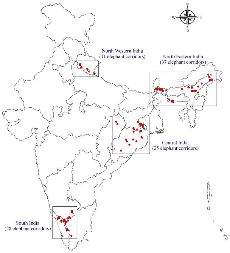
et al., 1995). Over the last 40 years, elephant corridors have shrunk to become small patches of
land. In 2017, the Wildlife Trust of India undertook research in partnership with "Project
Elephant" and the "Elephant Family" organization. Researchers discovered that India has 101
elephant corridors. There are 28 in South India, 37 in North East India, 25 in Central India, and
11 in northwest India (Fig. 1). This survey also discovered that approximately 70% of corridors
are utilized on a routine basis, 25% are used infrequently, and 6% are hardly used (Sundararaju,
2018).
Figure 1. Known elephants’ habitat corridors throughout India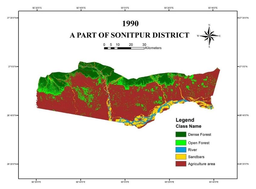
4 | Journal of Wildlife and Biodiversity 6(X): X-X (2022)

Infrastructure prosperity and natural wildlife fragmentation have all been observed throughout
the north-eastern region of India. For this, an acute conflict has recently occurred between
humans and Asian elephants, as both elephants and the human population are gradually
expanding, as enormous swaths of forests are turned into cropland, military barracks, and urban
civilization (Naha et al., 2019). According to the most recent population estimates made by the
Indian Government, the population of elephants is estimated to be 27,000 individuals scattered
over 23 Indian states covering an area of around 1,09,500 square km (Lenin & Sukumar, 2011).
Sonitpur district belongs to Eastern India. It is one of the largest districts of Assam, situated in
the north Assam division. It,s headquarter is Tezpur. It is located at latitude 26.7°N and longitude
92.85°E and occupies an area of approximately 5324 km2. Out of total areas the forest coverage
area is 960 km2 of which 56 km2 is a very dense forest, 280 km2 is a moderately dense forest and
624 km2 is an open forest.
Asian Elephant (Elephas maximus) is listed by IUCN as endangered species. In spite of major
threats, they still exist (Lenin & Sukumar, 2011). Habitat loss, fragmentation of elephant
population, human-elephant conflicts, and illegal killing of elephants adversely affected elephant
conservation. Human-animal conflict adversely affected human life in the form of loss of crops
and property, as well as the death of local people (Chartier et al., 2011). These incidents
aggravated the crudeness of local communities which leads to the retaliatory killing of elephants
and undermining of conservation efforts (Hoare & Du Toit, 1999).
The IUCN designates the Asian Elephant (Elephas maximus) as an endangered animal. Despite
serious dangers, they continue to survive. Elephant conservation has been hampered by habitat
degradation, elephant population segmentation, man-elephant conflict, and illicit elephant
poaching. Human-animal conflict harmed people's lives by causing agricultural and economic
losses, and the deaths of residents in the area. These occurrences reinforced the offensiveness of
local tribes, leading to vengeful elephant killings and weakening wildlife conservation (Chartier
et al., 2011).
In India, around 22% of habitats of elephants fall within protected areas and around 30% of
elephants live within dense huge forest areas. But the majority of the population is in a highly
fragmented landscape with human densities. With these backgrounds as there is a chance of
extensive overlap with humans for sharing resources. Therefore, every time conflicts are
inevitable. As a result, the elephant population has a lower chance of long survival.
Due to the increase in human population and development in northeast India, wildlife habitat has
been reduced and fragmented. As a result, human-wild conflict arises. Between 1980-2003 due
to the human-elephant conflict in North East India 1150 humans and 370 elephants died.
Fragmentation of habitats occurred due to an increase in human immigration from neighboring
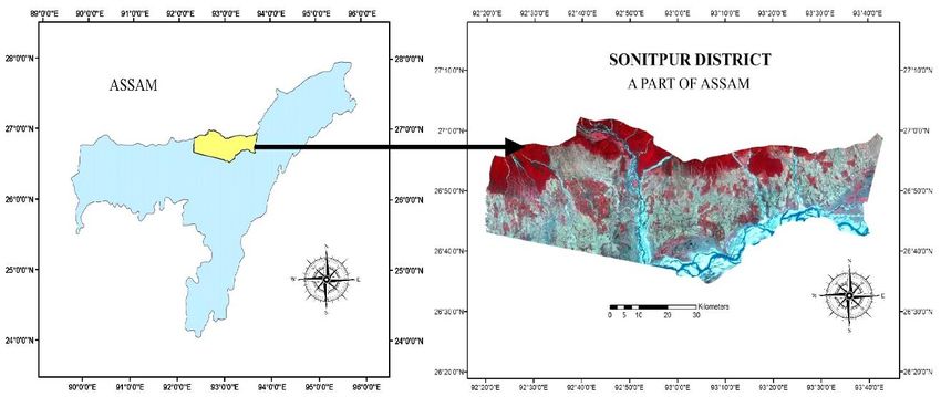
5 | Journal of Wildlife and Biodiversity 6(X): X-X (2022)

regions. The prime elephant habitat has been occupied by humans. This leads to human-elephant
conflict now and then (Choudhury, 1999). Expansion of local land usage, deforestation, grazing
land alteration, agricultural expansion, and urbanization, as per existing literature, all made
significant contributions to land-use changes (Lambin et al., 2001; Chartier et al., 2011). For this
reason, human-elephant conflict is increasing day by day.
Remote sensing technology is a useful approach for analyzing alterations in corridors because of
its capacity to offer actual information with comprehensive and recurrent coverage, which is a
substantial advantage over conventional techniques. Land use/cover alterations can be detected
using spatiotemporal satellite photos. Satellite imagery data combined with GIS and GPS enable
the acquisition, analysis, and interpretation of animal habitats information on a variety of time
periods and at a low cost (Kushwaha, 2002; Kushwaha & Roy, 2002). Remote sensing already
has contributed significantly to the collection of valuable data on forest cover, plant varieties,
and land-use changes. During the last 30 years, several research has employed these approaches
to analyze animal habitats (Botkin et al., 1984; Kushwaha, 1997; Houghton & Woodwell, 1981;
Malingreau, 1991). This study aimed to: analyze the change in land use pattern, estimate the
extent of land use land cover change in the area of study, and determine the source of elephant
habitat loss and degradation in the study area.

Materials and methods
Study Area
The present study was conducted throughout Sonitpur District, Assam, India. The total area of
Sonitpur District is 5204 sq. km. It extends from 92o20’E to 93o50’E and 26o15’N to 27o21’N.
Sonai-Rupai Wildlife Sanctuary, Nameri Tiger Reserve (including Nameri National Park), Bura-
Chapori Wildlife Sanctuary, Chaduar, Balipara, Noeduar, Biswanath, and Behali Reserve Forest
are in Sonitpur District. The Forest area of Sonitpur District is very important to stretch of
elephant habitat which extends from northern West Bengal through the Himalayan Foothills and
Dooars covering Southern Bhutan. The total forest cover area of Sonitpur District is 1069.61 sq.
km. So 20.55% area is under forest in Sonitpur District.
6 | Journal of Wildlife and Biodiversity 6(X): X-X (2022)

Figure 2. A map of the study area and sampling location. The current study was initiated in view of
a proper assessment of forest cover change as the Man-Elephant Conflict has reached alarming
proportions in recent years.

Data Collection and analysis
Secondary Data were collected from Landsat 5 (for 1990 and 2009) and Landsat 8 (for 2019)
satellite images which were downloaded from USGS. Satellite images were used to detect the
forest cover as well as land-use change. Acquired images were of the month of January and
February to maintain seasonal vegetation characteristics. For data analysis, Remote sensing and
GIS techniques were used. Satellite images of 1990, 2009, and 2017 were downloaded from
USGS. Then images were geo-referenced through GIS software (ERDAS IMAGINE). Through
GIS Software Satellite images were classified (Supervised Classification) as dense forest, open
forest, agricultural land, water bodies, sandy areas, etc. to analyze the expansion of agricultural
land and destruction of forest area.
7 | Journal of Wildlife and Biodiversity 6(X): X-X (2022)
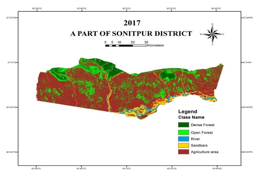
Figure 3. Forest cover change from 1990 to 20178 | Journal of Wildlife and Biodiversity 6(X): X-X (2022)
Result
Figure 3 (a-c) shows the land cover and land-use change in the Sonitpur district area during 1990,
2009, and 2017 respectively. It also indicates the decline of forest cover during that time period.
Here five major land use and land cover (LULC) categories were characterized using field
investigation data and Landsat data i.e., dense forest, open forest, agricultural land, water bodies,
and sandy areas. In 1990, dense forest cover was almost about 15.45% has been decreased by
9.95% in 2009 and only 6.69% in 2017 respectively in the entire district (Table 1). The entire
dense forest areas of the Sonitpur district deteriorated during the past several decades in the forms
of targeted cutting, burning, grazing, fuels, and timber wood collecting, resulting in the
establishment of a secondary ecological succession stage. The report also emphasizes that
perhaps the dense forest-covered region has been changed into some other type of land coverage,
indicating that the area is under heavy anthropogenic stress. The findings also indicated that the
area of water bodies, sandy areas, and dense forests were reduced because of changes in land-
use patterns.
Table 1. Land use and land cover change (LULC) of Sonitpur, Assam, India
Class Dense Open Agricultural Water Sandy
Year Forest Forest Land Bodies Areas
1990 (%) 15.45 12.63 62.49 2.50 6.93
2009 (%) 9.95 15.85 65.95 2.03 6.22
2017 (%) 6.69 18.65 66.87 1.87 5.92
Net Change (%)
-5.5 3.22 3.46 -0.47 -0.71
1990-2009
Net Change (%)
-3.26 2.80 0.92 -0.16 -0.3
2009-2017
Net Change (%)
-8.76 6.02 4.38 -0.63 -1.01
1990-20179 | Journal of Wildlife and Biodiversity 6(X): X-X (2022)
80
70
Area (Percentage %)
60
50
40
30
20
10
0
A B C D E
LULC classes
1990 2009 2017
Figure 4. Change in land use and land change (1990 to 2017) in different land use (A: Dense Forest, B:
Open Forest, C: Agriculture land, D: Water bodies, E: Sandy areas).
Discussion
In the Sonitpur district, elephant habitats were mainly found in dense forest region which is
tropical evergreen forest. The result indicates that dense forest decreases more in-between the
years 1990 to 2009 than in the interval between 2009 to 2017. But the percentage of open forests
increased from 1990 to 2017. In 1990 there was 12.63% open forest but in 2009 it was increased
to 15.85% and further in 2017 it was increased to 18.65% and the total increment of open forest
area is almost about 6.02% during the period of 1990 to 2017 due to huge amount of
deforestation. In 1990 there was almost 62.49% agricultural land cover and it increased to
65.95% in 2009 and further increased to 66.87% in 2017 (Fig. 4). Agricultural land was increased
from 1990 to 2017 and the major changes occurred in the period 1990 to 2009. So, a massive
amount of land-use changes was detected from 1990 to 2017. Changes were also observed in
waterbodies land cover changes. Land cover of water bodies also decreased during the period
1990 to 2017 and it also affected the other land cover changes. These changes were mostly caused
by increasing biotic stress as a result of the district's rising human population, particularly along
elephant corridors. The dense forest corridor regions were found to be transformed into open
forest and agricultural land.
The forest has been deforested due to socio-political problems as the area is dominated by the
Bodo tribe and they are demanding a separate Bodo province for a long time. The other cause is
that the paddy is a major crop in that area and the increase in agriculture is resulting in a huge10 | Journal of Wildlife and Biodiversity 6(X): X-X (2022)
amount of deforestation. On the other hand, the paddy crop attracts elephants and as a result, the
loss of elephant and human lives occurs due to man-elephant conflict (Kushwaha & Hazarika,
2004).
Conclusion
Now a day’s destruction of the Elephant Corridor is a burning issue in North-East India as well
as in the whole of India. From 1990-to 2017 huge amount of dense forest was degraded because
of the rapid rate of deforestation. So the corridors should be identified as restricted areas by the
concerned authorities so that the elephant can move freely along the corridors and can move from
one habitat to another. Plantation along Corridors should be done because this will ensure the
uninterrupted movement of elephants across their habitats and plantation drive may help in the
reduction of the human-elephant conflict. To protect the elephant habitats and corridors, illegal
agricultural lands should be converted into natural forest areas. Besides these, anthropogenic
activities should be stopped in the corridors and buffer areas. Local communities as well as govt.
should take various steps to do so. Govt. should take legal steps for killing elephants. Some
precautionary actions must be adopted, as well as future research is necessary to mitigate ongoing
forest area degradation.
References
Aalen, F. H. A. (1997). Management of the landscape. In F. H. A. Aalen, K. Whelan, & M.
Stout (Eds.), Atlas of the Irish rural landscape (pp. 255–259). Cork University Press.
Aggarwal, M. (2017). India’s elephant population decreases by 10% to 27,312. Mint.
https://www.livemint.com/Politics/OhPuqM871gkivaj5zetCZJ/Indias-elephant-
population-decreases-by-10-to-27312.html
Baishya, J. B., Talukdar, N. R., & Choudhury, P. (2021). Status and Distribution of Asian
Elephants in the Nagaon Forest Division, Assam. Gajah, 53, 39–42.
Botkin, D. B., Estes, J. E., MacDonald, R. M., & Wilson, M. V. (1984). Studying the earth’s
vegetation from space. Bioscience, 34(8), 508–514. https://doi.org/10.2307/1309693
Chartier, L., Zimmermann, A., & Ladle, R. J. (2011). Habitat loss and human-elephant conflict
in Assam, India: does a critical threshold exist? Oryx: The Journal of the Fauna
Preservation Society, 45(4), 528–533. https://doi.org/10.1017/s0030605311000044
Choudhury, A. (1999). Status and conservation of the Asian Elephant Elephas maximus in
north-eastern India. Mammal Review, 29(3), 141–174. https://doi.org/10.1046/j.1365-
2907.1999.00045.x
Edge, W. D., & Sukumar, R. (1991). The Asian elephant: Ecology and management. The
Journal of Wildlife Management, 55(1), 201. https://doi.org/10.2307/3809262
Hoare, R. E., & Du Toit, J. T. (1999). Coexistence between people and elephants in African
savannas. Conservation Biology: The Journal of the Society for Conservation
Biology, 13(3), 633–639. https://doi.org/10.1046/j.1523-1739.1999.98035.x11 | Journal of Wildlife and Biodiversity 6(X): X-X (2022)
Houghton, R. A., & Woodwell, G. M. (1981). Biotic contributions to the global carbon cycle:
The role of remote sensing. In P. G. Burroff & &. D. B. Morrison (Eds.), Proceedings of
the seventh international symposium on machine processing of remote sensing data (pp.
593–602).
Johnsingh, A. J. T., & Williams, A. C. (1999). Elephant corridors in India: lessons for other
elephant range countries. Oryx: The Journal of the Fauna Preservation Society, 33(03),
210. https://doi.org/10.1017/s0030605300030556
Kushwaha, S. P. S. (1997). Environmental monitoring and cyclone impact assessment on
Sriharikota Island, India. India. Geocarto International, 12, 55–62.
Kushwaha, S. P. S. (2002). Geoinformatics for wildlife habitat characterization. In Proceedings
of map India fifth annual international conference (pp. 293–302).
Kushwaha, S. P. S., & Hazarika, R. (2004). Assessment of habitat loss in Kameng and Sonitpur
Elephant Reserves. Current Science, 1447–1453.
Kushwaha, S. P. S., & Roy, P. S. (2002). Geospatial technology for wildlife habitat
evaluation. Tropical Ecology, 43, 137–147.
Lambin, E. F., Turner, B. L., Geist, H. J., Agbola, S. B., Angelsen, A., Bruce, J. W., Coomes,
O. T., Dirzo, R., Fischer, G., Folke, C., George, P. S., Homewood, K., Imbernon, J.,
Leemans, R., Li, X., Moran, E. F., Mortimore, M., Ramakrishnan, P. S., Richards, J. F.,
… Xu, J. (2001). The causes of land-use and land-cover change: moving beyond the
myths. Global Environmental Change: Human and Policy Dimensions, 11(4), 261–269.
https://doi.org/10.1016/s0959-3780(01)00007-3
Leimgruber, P., Gagnon, J. B., Wemmer, C., Kelly, D. S., Songer, M. A., & Selig, E. R. (2003).
Fragmentation of Asia’s remaining wildlands: implications for Asian elephant
conservation. Animal Conservation, 6(4), 347–359.
https://doi.org/10.1017/s1367943003003421
Lenin, J., & Sukumar, R. (2011). Action plan for the mitigation of elephant-human conflict in
India. Final Report to the US Fish and Wildlife Service. Asian Nature Conservation
Foundation.
Mahato, R., Nimasow, G., Nimasow, O. D., & Bushi, D. (2021). Assessing the tropical forest
cover change in northern parts of Sonitpur and Udalguri District of Assam,
India. Scientific Reports, 11(1), 11170. https://doi.org/10.1038/s41598-021-90595-8
Malingreau, J. P. (1991). Remote sensing and geographic information systems for resource
management in developing countries (A. S. Belward & C. R. Valenzuela, Eds.).
Kluwer.
Naha, D., Sathyakumar, S., Dash, S., Chettri, A., & Rawat, G. S. (2019). Assessment and
prediction of spatial patterns of human-elephant conflicts in changing land cover
scenarios of a human-dominated landscape in North Bengal. PloS One, 14(2),
e0210580. https://doi.org/10.1371/journal.pone.0210580
Nandy, S., Kushwaha, S. P. S., & Mukhopadhyay, S. (2007). Monitoring the Chilla–Motichur
wildlife corridor using geospatial tools. Journal for Nature Conservation, 15(4), 237–
244. https://doi.org/10.1016/j.jnc.2007.03.003
Sarma, P. K., Sarma, K., Das, J. K., Das, J. P., & Talukdar, B. K. (2021). Tracing out of
elephant corridors and landscape dynamics of Eastern Assam using geospatial tools: A
case.12 | Journal of Wildlife and Biodiversity 6(X): X-X (2022)
Soule, M. E., & Gilpin, M. E. (1991). The theory of wildlife corridor capability. In &. R. J. H.
D. A. Saunders (Ed.), Nature conservation 2: The role of corridors. Surrey Beatty &
Sons.
Srivastava, R., & Tyagi, R. (2016). Wildlife corridors in India: Viable legal tools for species
conservation? Environmental Law Review, 18(3), 205–223.
https://doi.org/10.1177/1461452916662114
Sundararaju, V. (2018). A Historic Judgement by the Supreme Court on Elephant Corridors.
down to earth. https://www.downtoearth.org.in/blog/wildlife-biodiversity/a-historic-
judgement-by-the-supreme-court-on-elephant-corridors-61585
Sunderraj, S. F. W., Mishra, B. K., & Johnsingh, A. J. T. (1995). Elephant use of the Rajaji-
Corbett corridor, northwest India. In J. C. Daniel & H. S. Datye (Eds.), A week with
elephants (pp. 261–269). Oxford University Press.
Vidya, T. N. C., Fernando, P., Melnick, D. J., & Sukumar, R. (2005). Population genetic
structure and conservation of Asian elephants (Elephas maximus) across India. Animal
Conservation, 8(4), 377–388. https://doi.org/10.1017/s1367943005002428
Williamson, M., MacArthur, R. H., & Wilson, E. O. (1969). The theory of island
biogeography. The Journal of Animal Ecology, 38(2), 464. https://doi.org/10.2307/2790
Wilson, E. O., & Willis, E. O. (1975). Applied biogeography. In M. L. Cody & &. J. M.
Diamond (Eds.), Ecology and evolution of communities (pp. 522–534). Belknap Press.You can also read