Economical and prudent use of soil in the Alps - Alpine ...
←
→
Page content transcription
If your browser does not render page correctly, please read the page content below

Economical and
prudent use of
soil in the Alps

          0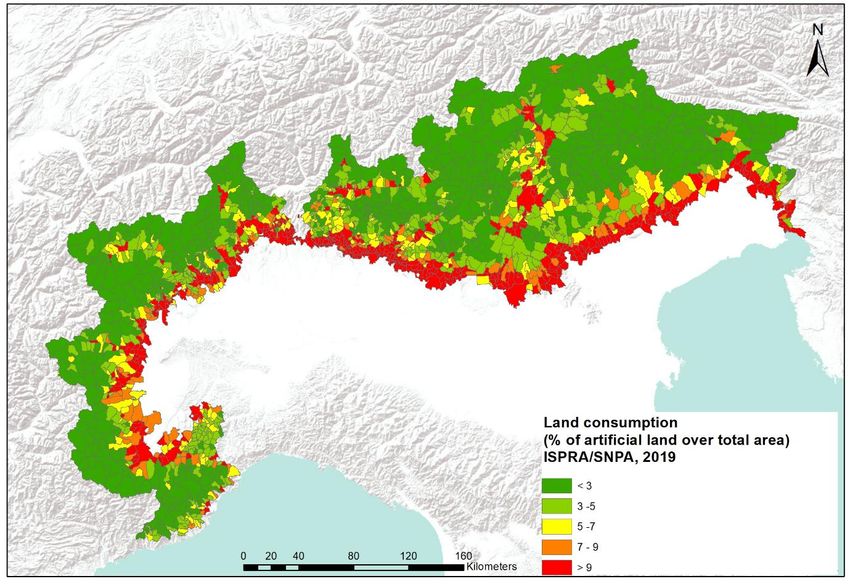
This report was approved by the Alpine Conference at its XVI meeting, held on 10 December
2020.

The report “Economical and prudent use of soil in the Alps” was coordinated by the German
Presidency of the Soil Protection Working Group and the Permanent Secretariat of the Alpine
Convention and has been drafted by the German Presidency of the Soil Protection Working
Group, its members and the Permanent Secretariat.

Coordination of Soil Protection Working Group

Presidency: Christian Ernstberger (German Federal Ministry for the Environment, Nature
Conservation and Nuclear Safety)
Permanent Secretariat of the Alpine Convention: Vera Bornemann

Members of the Soil Protection Working Group

Austria: Andrea Spanischberger (Austrian Federal Ministry for Climate Action, Environment
Energy, Mobility, Innovation and Technology), Thomas Peham (Government of Tyrol & ARGE
Alp), Christian Steiner (Government of Lower Austria, Authority for Agriculture and Spatial
Development)
France: Frédéric Berger (French National Research Institute of Science and Technology for
Environment and Agriculture, Grenoble Regional Centre), Marina Le Loarer – Guezbar (French
Ministry for the Ecological Transition)
Germany: Frank Glante (Environmental Agency), Jochen Daschner (Bavarian State Ministry for
the Environment and Consumer Protection), Bernd Schilling (Bavarian State Agency for the
Environment)
Italy: Maurizio Federici (Region Lombardy), Sara Pace (Region Lombardy), Chantal Trèves
(Autonomous Region Aosta Valley), Ciro Amato (Italian Delegation to the Alpine Convention),
Michele Munafò (Italian Institute for Environmental Protection and Research)
Liechtenstein: Daniel Kranz (State Administration of the Principality of Liechtenstein)
Slovenia: Petra Karo-Bešter (Slovenian Environmental Agency), Jože Ileršič (Slovenian Ministry
of Agriculture, Forestry and Food), Petra Božič (Slovenian Ministry of Agriculture, Forestry and
Food)
Switzerland: Alexis Kessler (Federal Office for Spatial Development)
Observer: Guido Plassmann & Veronika Widmann (ALPARC), Marion Ebster (CIPRA
International), Liliana Dagostin (Club Arc Alpin), Nicolas Chesnel (Interreg Alpine Space),
Ursula Schüpbach (ISCAR), Maria Schachinger & Elisabeth Sötz (WWF)

                                               1
Table of contents
1. Why is it crucial to use our soil economically and prudently? ............... 4
2. How is soil “consumed”? ......................................................................... 5
  2.1 Main drivers for soil consumption in the perimeter of the Alpine Convention .... 5
3. Facts and figures ..................................................................................... 7
  3.1 Figures from the Alpine States .............................................................................. 10
  3.2 Legally binding quantitative limitations for soil consumption and soil sealing . 19
  3.3 Targets for maximum soil consumption............................................................... 24
4. Main challenges regarding an economical and prudent use of soil .... 27
5. Possible solutions .................................................................................. 29
  5.1 An effective solution for economical and prudent use of soil per Alpine State 29
  5.2 A glance of soil awareness activities in the Alps ................................................. 32
  5.3 Voices of the next generation ................................................................................ 33
6. Spotlight on soil & climate protection ................................................... 35
  6.1 Humus – carbon stocks in soil .............................................................................. 35
  6.2 Wetland, peatland, and moor areas ....................................................................... 37
7. Monitoring soil consumption ................................................................ 41
8. Soils for food: How to safeguard agricultural production areas? ....... 42
9. Outlook ................................................................................................... 44
Sources and further information ............................................................... 45

                                                          2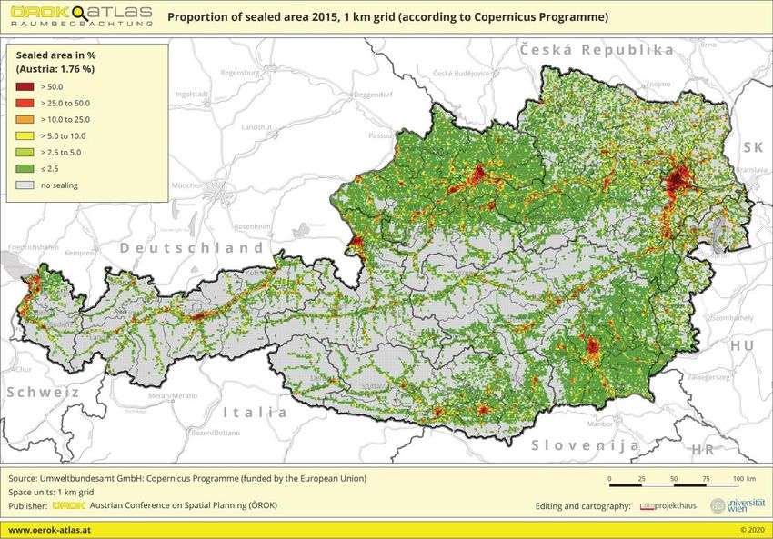
List of figures
Figure 1: Average annual change in soil sealing in the EU 2006-2015. Source: EEA 2020d. ..... 8
Figure 2: Soil suitability for human activities in the Alpine Convention. ....................................... 9
Figure 3: Share of land use categories in Austria, Tyrol, Lower Austria and in the Alpine
         Convention perimeter of Lower Austria. .......................................................................... 10
Figure 4: Share of sealed areas 2015 in a 1 km raster (according to the Copernicus High
         Resolution Layer Imperviousness). Source: ÖROK Atlas 2020..................................... 11
Figure 5: Land consumption in the Bavarian area inside the Alpine Convention perimeter. ... 12
Figure 6: Degree of surface sealing in Bavaria in 2015 (settlement and transportation area).12
Figure 7: Artificial Land cover in the perimeter of the Alpine Convention in 2019 at municipal
         level. Source ISPRA - SNPA 2020...................................................................................... 16
Figure 8: Structure of land cover and land use categories in Slovenia 2018.. ........................... 17
Figure 9: Changes in total area of land cover-land use categories, Slovenina, by period, 1996-
         2000, 2000-2006, 2006-2012, 2012-2018. ....................................................................... 18
Figure 10: Flows of land cover changes, Slovenia (LEAC, EEA methodology). .......................... 18
Figure 11: Organic carbon stock in Austrian topsoils (0-30 cm) in tonne per hectare. Source:
         Haslmayr et al. 2018. .......................................................................................................... 36
Figure 12: North Italy Soil Organic Carbon stock in t/ha of mineral topsoil layers (0-30cm),
         humus and litter layers excluded. Source: Joint Research Centre – European Soil
         Data Centre 2020. ............................................................................................................... 36
Figure 13: Map of peatlands, based on 76 datasets, in the Alps in the perimeter of the
         maximum extend of the Riss glaciation. Source: Reichart, A. F. (2020). .................... 38
Figure 14: Organic soils in Bavaria. .................................................................................................. 39

List of tables
Table 1: Share of sealed land of the total State’s territory. Data source: EEA 2020c. ............... 8
Table 2: Artificialized soils in French departments inside or partly inside of the French AC
         perimeter and France. Source: Agreste - Statistique Agricole Annuelle (SAA) 2020.14
Table 3: Land consumption in the Italian municipalities inside the AC perimeter displayed per
         Region. Data source: ISPRA - SNPA 2020. ................................................................... 15
Table 4: Land consumption in Liechtenstein. Data source: Amt für Statistik Fürstentum
         Liechtenstein 2020. ........................................................................................................ 16
Table 5: Land consumption in Switzerland. Data source: Bundesamt für Statistik 2020. ...... 19
Table 6: Targets for maximum soil consumption....................................................................... 24
Table 7: Peatland protection - Rewettened areas in the perimeter of the Alpine Convention. 38
Table 8: Wetlands in the Italian Alpine Regions. ......................................................................... 40

                                                                     3
1. Why is it crucial to use our soil economically and prudently?

We need our soil for producing food, for growing forests, for filtering, storing, transforming and
purifying water, nutrients and substances, for regulating the water household, for local climate
regulation and for global climate regulation by playing a crucial role in the carbon cycle.
Biodiversity in soils is the basis for biodiversity above soils. Soils store history: one can find
puzzle pieces of natural events, human history and ancient climate changes in soils. We enjoy
walking on soil: on mountain pathways, in mountain forests, thorough meadows and yet rarely
think about, that it is all there only because of soils. The reason is simple: we often do not think
about things we cannot see, and this is valid for soil: it is only recognized, where it lays open.
But it is time for realizing that we need to do more to preserve our soils. This is not only needed
for preserving a good quality of our soils, but also common efforts by everyone are necessary
to ensure, that enough healthy soils will be left to guarantee that also our children will have
enough food, clean water, diverse species of animals and plants around them and will be able
to walk through mountain forests, green meadows and along vivid streams.

                         “A nation that destroys its soil destroys itself.”
                                  (Franklin D. Roosevelt, 1937)

Soil is the basis for life on Earth - the living skin of the Earth. In constant interaction between
earth, air, water, and living organisms, it is a place for the exchange of matter and energy. It is
considered a non-renewable resource because of the long times required for its formation.
Soils are at the heart of major environmental issues, such as the availability of quality water,
the preservation of biodiversity, food security, natural risks mitigation. Soils can also help
against or contribute to climate change, depending on how we treat them.

                  Soil protection is climate protection and nature protection!

Because of its essential role, soils are subject to multiple land use demands for human
activities, which can cause soil degradations, such as soil pollution, soil compaction and the
mostly permanent degradation of soils for buildings and infrastructure.

What is special in the Alps?
Looking at landscape and settlement systems in the Alps it is easy to identify patterns: most
constructions are located, where it is suitable to build them. Flat areas, which are suitable
spaces for settlements and other intensive land uses, are more limited in the mountains then
in other regions. At the same time, the identic locations are often those with the most
productive soils.
Comparable to the melting Alpine glaciers visualising global climate change, the fast growth
of consumed land in many Alpine valleys visualises the rapid loss of soils by human activities.

But it is possible to act! Preserving soil means acting on one of the main challenges, humanity
is facing.

                                                 4
2. How is soil “consumed”?

The definition of soil consumption and soil sealing is complex and differs in the Alpine
Countries. Thus, the Compliance Committee of the Alpine Convention (Compliance Committee
of the Alpine Convention 2019) has defined the terms as follows:

   -   “Soil/ land consumption (land take) means the loss of mainly agricultural and
       biologically productive soils through building, for example for settlement, traffic and
       leisure purposes. Approximately 40% of these areas are sealed and thus lose all their
       biological functions.
   -   Soil sealing means covering the ground by an impermeable layer. Thus, the soil is
       reduced to its function as platform for man-made structures and loses its natural
       functions. Buildings, but also areas that are covered by concrete, asphalt, or paving
       stones (pathways, parking lots, driveways, company premises etc.) are considered as
       completely sealed areas.”

2.1 Main drivers for soil consumption in the perimeter of the
    Alpine Convention

The need of soil and land from multiple different perspectives makes it an issue on which
many players must work together. Thus, there are different drivers of soil and land
consumption and they are connected to each other. As non-exhaustive aspects of important
drivers for soil consumption in the Alps can be considered:

Residential building and construction
Extensions of settlements are important drivers of land consumption. Urban sprawl, detached
housing and a lack of regional and supra-municipal planning coordination and control in spatial
planning are drivers of the growing demand for land. The growing number of small households,
raising living standards and by this the desire for larger apartments lead to increased living
space requirements and to an increasing land consumption. Whereas high land prices can
often result in high building density, comparably low land prices can lead to higher land take
per person. However, in the densification of urban settlements, care must be taken to ensure
sufficient green spaces to adapt to climate change. As another driver of land take can be
considered declining stock market returns since investors turn towards the real estate market.
Depending on the region different demographic developments with population growth in
dynamic regions on the one hand, and on the other population decline in less favoured and
peripheral regions need to be considered.

Industrial and commercial and logistics purposes
Growth focused economic development in general is associated with a high demand for
limited open spaces. Trade and commerce compete for locations and municipalities for
residents. This can result in a high demand for building plots in the outskirts.

                                              5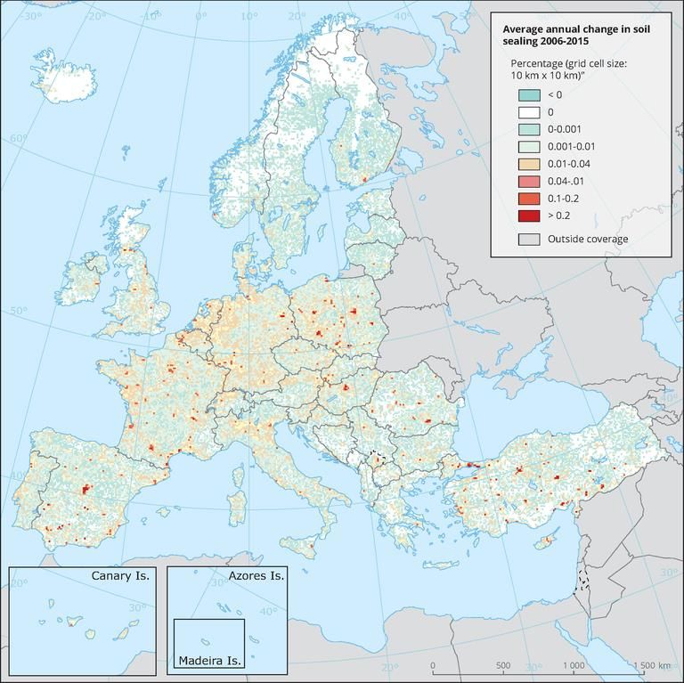
Transport infrastructures
 Improving road standards and building new roads also presents a constant land demand.
Despite generally rising land prices, strong price differences exist between rural and urban
areas. Consequently, increasing commuter movements and increasing freight transport lead
to an increased need for mobility and transport infrastructure.

Touristic and leisure time facilities
Tourism and leisure time facilities also entail spatial demands. Furthermore, some tourist
activities take up large areas, which are only used seasonally. In most Alpine Countries, like in
Austria, this applies especially to regions inside of the perimeter of the Alpine Convention since
they are strongly influenced by tourism.

Renewable energy
There is a high demand for spaces for photovoltaic, large-scale solar power plants as well as
for hydropower reservoirs in order to achieve the climate targets. This objective is in
competition with e.g. the conservation of valuable agricultural or natural land and needs to be
handled with care.

                                                6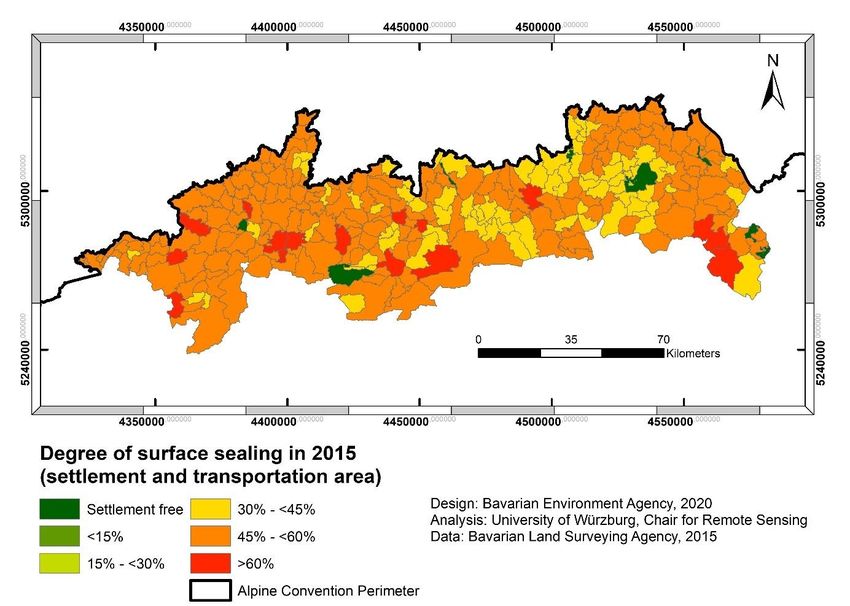
3. Facts and figures

It is important to know, that even though a definition of soil consumption and soil sealing has
been defined by the Compliance Committee of the Alpine Convention in 2019, the issue has
been researched for a long time and very different data sets have been developed. Thus, the
methods behind data sources and the definitions behind the topic differ significantly between
states, regions, municipalities, and even different sectors. It must be considered that against
this background the data displayed from the single Alpine States are mostly not directly
comparable but can only be considered as tendencies.
There are different programs based on remote sensing to enable gaining data not only for
supporting the nations in facing this issue but also to allow a comparison by generating
harmonious data. However, the topic of soil consumption and sealing comprises very detailed
spatial patterns thus, all approaches entail both, advantages and disadvantages.

The CORINE (Coordination of Information on the Environment) research programme was
launched on a proposal from the European Commission in order to collect and bring together
data on the state of the environment and natural resources. This database was initiated in
1985 and the datasets from 1990, 2000, 2006, 2012 and 2018 have been completed. The
CORINE Land Cover database is based on the interpretation of remotely sensed images whose
analysis is cross-referenced with existing maps and aerial photographs. Amongst others the
European Environmental Agency (EEA) takes CORINE Land Cover data for informing about
land take (EEA 2020a). But “while the level of detail provided by the CORINE Land Cover project
has allowed largescale international comparisons and helped raise awareness of the extent of
landscape changes across the EU, it cannot provide a meaningful database for local
approaches (Decoville & Schneider 2015). It can also lead to a high error rate in terms of
interpretations (Batista et al. 2013). So while it can be useful for general comparisons and
observing trends, it is not ideal for measuring the evolution of land take within nations. Any
figures based on the data should be considered a conservative estimate. ” (Science for
Environment Policy 2016). This is also valid for the specific orographic and land use patterns
in the Alps.

The Copernicus mission developed high resolution imperviousness data available for 2006-
2015, which can supplement the land take indicator with its information with a higher spatial
resolution and a more direct measurement of imperviousness (EEA 2020b). With this high
resolution of 20-100m pixel size and the new method this data marks a significant
improvement (Copernicus Land Monitoring Service 2020). The data is still not sufficiently
exact for the use on a regional or local level, since soil sealing patterns are often smaller than
the used resolution of 20-100m. But keeping this in mind, the data allows comparison between
the Alpine States.

                                                7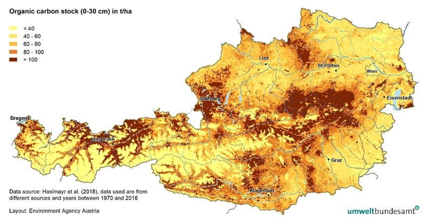
Table 1 gives an impression of the percentage of sealed area of the total State’s territory in
2006 and in 2015. The map in figure 1 displays the average annual change in soil sealing
between 2006 – 2015 in the EU. Differences between these data and following national data
are caused by different methods, sources, different data acquisition and processing as well as
differing definitions of soil consumption and soil sealing as explained above.

                State                 Share of sealed land of the total State’s
                                      territory
                                      2006                    2015
                Germany               4,18 %                  4,31 %
                Slovenia              1,62 %                  1,68 %
                Austria               1,72 %                  1,78 %
                Italy                 2,66 %                  2,74 %
                France                2,09 %                  2,19 %
                Switzerland           2,69 %                  2,79 %
                Liechtenstein         4,43 %                  4,51 %
Table 1: Share of sealed land of the total State’s territory. Data source: EEA 2020c.

Figure 1: Average annual change in soil sealing in the EU 2006-2015. Source: EEA 2020d.
                                              8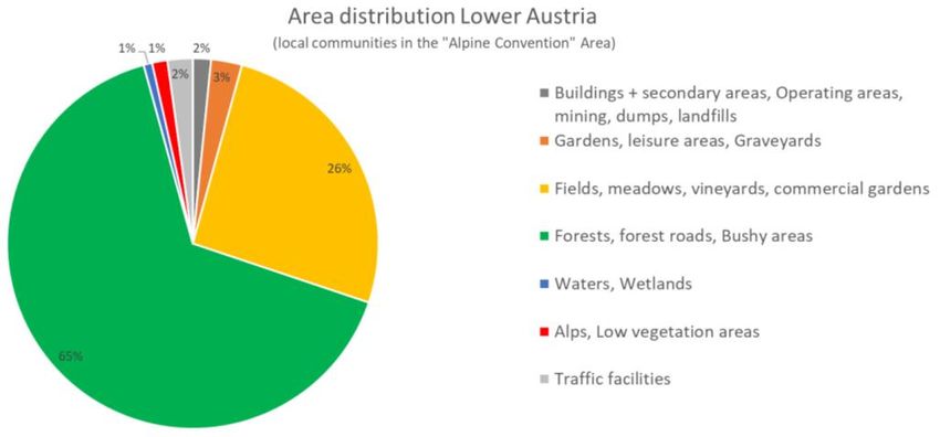
In total numbers soil consumption in the Alpine area tends to be lower than in surrounding
flatter land which can result from a lower share of population and settlements. But at the same
time the part of the Alpine area which is suitable for constructions and agricultural use is much
less compared to the surrounding flatter areas like figure 2 shows. The soil sealing rates thus
need to be contrasted by the area of land, which is suitable to provide a platform for most
human activities.

Figure 2: Soil suitability for human activities in the Alpine Convention.

                                                9
3.1 Figures from the Alpine States
In Austria 5.729 km² soil was consumed (taken land) until 2019, this accounts to ca. 7 % of the
Austrian territory and to ca. 18% of the permanent settlement area (Environment Agency
Austria 2020). The permanent settlement area in Austria comprises 37% on average, with a
wide range from 12% in Tyrol to 74% in Vienna. It should be noted that currently 20% of the
permanent settlement area is covered by settlement and traffic areas. In 2011 it was only 15%.
Figure 3 compares the shares of different land use categories in Austria, Tyrol, Lower Austria
and the part of Lower Austria laying within the Alpine Convention perimeter (ALP). Defined as
“consumed land” are the categories “buildings and side areas, industrial and commercial
areas, mines, dumps and landfill areas”, “gardens, leisure areas, cemeteries” as well as “traffic
areas”. The example of Lower Austria, that lies only partly inside the ALP, visualised that
significant land use differences between the whole territory and the ALP territory do exist. With
a similar share of “consumed land” the agricultural used area is reduced by almost half to 26
%. Differences in land use are even more significant in comparison with Tyrol, which lays
completely within the ALP.
Figure 3: Share of land use categories in Austria, Tyrol, Lower Austria and in the Alpine
Convention perimeter of Lower Austria.
10Based on the above-mentioned Copernicus high resolution layer imperviousness the ÖROK
atlas for spatial observation provides overviews on the soil sealing in Austria. The Alps are
highly visible in figure 4, which is displaying the share of sealed areas in 2015 in a 1 km grid.
While on first sight the Alpine area looks less affected by sealing a closer look reveals a high
percentage of sealing in the Alpine valleys.
Figure 4: Share of sealed areas 2015 in a 1 km raster (according to the Copernicus High
Resolution Layer Imperviousness). Source: ÖROK Atlas 2020.
In Bavaria 10 hectares per day were additionally consumed for settlement and traffic areas in
2018. In the overview in figure 5 a direct comparison between the data before and after 2013
is not possible due to changes in the nationwide uniform statistics of the surveying
administrations. The Bavarian State Planning Act plans to introduce a benchmark of a
maximum of 5 ha for additional land use for settlement and transport purposes. The area of
the Alpine Convention perimeter in Bavaria comprises around 11.127 km² and thus around
15.8% of the total areal extend of Bavaria.
11Figure 5: Land consumption in the Bavarian area inside the Alpine Convention perimeter.
Bavaria examined the degree of surface sealing of all designated settlement and traffic areas
in the municipalities in detail in 2007 by using satellite images from 2000. This study was then
repeated using data from 2015. In 2015 the average degree of surface sealing of designated
settlement and traffic areas on the municipal level for the perimeter of the Alpine Convention
was around 49.5% and 50.9% for the whole area of Bavaria. The “Landsat” images used had a
30 m resolution and were classified with a total accuracy between 70 and 84%. The study
considered streets and railroads with a likely width below 30 m with additional vector datasets.
Figure 6: Degree of surface sealing in Bavaria in 2015 (settlement and transportation area).
12As mentioned before the type of data source used is significant for being able to display
meaningful data on soil consumption. Three main sources of data are available to measure
soil uses and artificialisation in France. Each of these sources entails biases for an accurate
measurement of artificialisation, defined by non-natural, agricultural and forest areas:
• CORINE Land Cover (CLC) covers the exhaustiveness of the territory, but the results are
obtained by extrapolation, and the survey is carried out only once every six years (see also
above).
• Teruti-Lucas (TL) is a survey and the results are also obtained by extrapolation from
measured points on the territory. It therefore does not provide an accurate measure of
artificialisation over the whole territory more than CLC does.
• The land files (LF) do not include land that is not included in the cadastre (such as the
public domain, which includes all roads). Conversely, as soon as a plot of land is classified
as "to be built on", it is counted as artificial, whereas it may remain unbuilt for years or even
decades.
As they are not based on the same methods of analysis, particularly in terms of spatial
resolution and nomenclature of accounted land, these sources are at the origin of various
estimates of the artificialisation processes. Data from land files, recorded at the scale of the
cadastral parcel, present the finest level of analysis and therefore allow precise measurement
of the dynamics of land use change. The following key data (France Statégie 2019) are
comparing these 3 sources and express the extend of differences. This can result in looking
e.g. at the increase in artificial surfaces:
• CLC: 16,000 ha / year for 2006-2012,
• TL: 61,200 ha / year between 2006 and 2014,
• LF: 23,000 ha / year between 2006 and 2016.
Only the Teruti-Lucas data allow a long-term analysis of artificialisation and thus of the
evolution of land use via this indicator. Since 1981, the increase in artificialized land has
averaged around 60.000 hectares per year. Artificialized land has thus increased from 3 million
to 5,1 million hectares, which represents a growth of 70%. This represents a much higher
growth than that of the population (+19%) in the same period.
Data based on the Teruti-Lucas surveys conducted between 2000 and 2019 on the topic of soil
consumption for the French Departments which lay completely or partly inside the French
perimeter of the Alpine Convention are given in table 2.
13Department inside Newly Newly Sum of Artificialized Artificialized
or partly inside of artificialized artificialized artificialized soils soils
the AC perimeter soils soils soils difference per inhabitant
& France 2000-2019 2000-2019 2019 2000-2019 (m²
(ha) (%) (%) (ha/day) 2019/inhabitan
t in 2020)
Drôme 12.706 1,94% 8,93% 1,74 1.100
Isère 9.825 1,25% 9,50% 1,35 600
Savoy 4.481 0,71% 5,11% 0,61 700
Upper Savoy 9.444 1,95% 11,06% 1,29 600
Alpes of Upper 8.033 1,15% 2,87% 1,10 1.200
Provence
Upper Alps 3.321 0,58% 2,67% 0,45 1.100
Maritime Alps 7.861 1,83% 9,15% 1,08 400
Var 32.170 5,33% 12,81% 4,40 700
Vaucluse 15.705 4,39% 15,28% 2,15 1.000
Sum Departments 103.546 2,13% 8,16% 14,17 700
France 1.008.263 1,84% 9,71% 138,04 800
Table 2: Artificialized soils in French departments inside or partly inside of the French AC
perimeter and France. Source: Agreste - Statistique Agricole Annuelle (SAA) 2020.
While the share of artificialized soils in 2019 in the departments which lay inside or partly inside
of the AC perimeter in not much lower than in the whole French territory, the percentage of
additional artificialized soils between 2000 and 2019 was even higher in the Alpine
departments than compared to the whole area of France.
According to the land records available since 2006, the increase in artificial land was lower in
the timespan 2006-2016, however, still higher than the population growth. In the period 2006-
2014 Teruti-Lucas and the land files are consistent in identifying a strong acceleration of
artificialisation just before a crisis in 2008 and then returned to a value below the long-term
average.
Inside of the perimeter of the Italian Alps lay 1.645 municipalities, 24 provinces and 7 regions,
adding up to an area of over 5.200 hectares.
Homogeneous data on land consumption in Italy are processed by the Italian Institute for
Environmental Protection and Research (ISPRA), which refers to the category “artificial land
cover”. Some Italian regions also have other data, which refer to the definitions of land
consumption introduced by the respective regional laws and mostly concern the consumption
on the basis of the municipal plans in force (urbanized surfaces or surfaces that can be
urbanized, also classifiable on the basis of the type of residential or other settlement). ISPRA
data on land consumption in Italy are available for 2012, 2015, 2016, 2017, 2018 and 2019. For
each year they are assessed at municipal, provincial, regional and national level (ISPRA 2020a).
The sealed part of land consumption is assessed since 2017 for all new artificial areas. The
soil sealing in 2019 was about 23% of total land consumption growth but it should be
considered that the 70% which is not sealed yet is classified as building site. It thus can be
assumed, that most of it will be sealed in the next years.
The analysis by ISPRA and the Italian National System for the Protection of the Environment
(SNPA) is based on the municipal level and considers some indicators for 2012 and 2019. As
illustrated in table 3 land consumption between 2012 and 2019 has grown by 2.734 hectares
(+1,44%) in the Italian part of the Alpine Convention perimeter. Trentino-Alto Adige/South Tyrol
14is the region in which land consumption has increased the most (1.074 ha, +2,54%). The
artificial land cover per inhabitant in the Alpine municipalities in Friuli-Venezia Giulia and
Liguria are the highest - respectively 735 and 728 m2 per inhabitant. Considering the whole
extend of the Italian Alpine Convention perimeter 2012 - 2019 more than 1 hectare per day was
lost.
Region Land Artificial land Land Land Land
(municipalitie consumption cover of total consumption consumption consumption
s in the AC growth area growth growth 2019
perimeter) 2012-2019 2019 2012-2019 2012-2019 (m2 per
(ha) (%) (%) (ha/day) inhabitant)
Piedmont 426 4,42% 1,00 0,17 502
Aosta Valley 124 2,15% 1,80 0,05 557
Lombardy 333 6,15% 0,76 0,13 345
Trentino-Alto 1.074 3,19% 2,54 0,42 408
Adige/South
Tyrol
Veneto 566 7,16% 1,70 0,22 491
Friuli-Venezia 179 5,32% 1,17 0,07 735
Giulia
Liguria 32 3,52% 0,60 0,01 728
AC perimeter 2.734 4,75% 1,44 1,07 447
Table 3: Land consumption in the Italian municipalities inside the AC perimeter displayed per
Region. Data source: ISPRA - SNPA 2020.
Mountain areas are generally less artificialized than other areas in Italy, where the average
artificial land cover of the total area is 7,1%. Considering the map of the land consumption in
municipalities in 2019 (figure 7) it is possible to see that the distribution of the artificial areas
is concentrated in the South, near Po Valley and in the valleys of Trentino-Alto Adige/South
Tyrol.
15Figure 7: Artificial Land cover in the perimeter of the Alpine Convention in 2019 at municipal
level. Source ISPRA - SNPA 2020.
According to the land-use statistic soil consumption in Liechtenstein amounts to 16,8 ha per
year in the timeframe between 1984 and 2014. The settlement area made up ca. 11 % of the
territory of Liechtenstein in 2014. (Amt für Statistik Fürstentum Liechtenstein 2020).
According to an evaluation of the land cover mapping data soil sealing in Liechtenstein
amounts to 8,37 ha per year (2015 – 2019).
1984 1996 2002 2008 2014 2015 2019
Consumed land
1.259 1.465 1.578 1.683 1.762
(in ha)
Land consumption since
206 113 105 79
previous period (in ha)
Settlement area (m²) per
471,9 470,4 466,0 472,9 471,6
inhabitant
Sealed land (in ha) 1.091,87 1.133,72
Land sealing since previous 41,85
period (in ha)
Table 4: Land consumption in Liechtenstein. Data source: Amt für Statistik Fürstentum
Liechtenstein 2020.
16As explained in more detail in a following chapter Slovenia is currently in the process of
collecting data on land consumption. There is no specific data yet on land cover and land use
for Alpine Convention perimeter in Slovenia, which encompass 62 whole or part municipalities
out of 212. However, for the complete territory of Slovenia data is available.
In 2018, more than half of Slovenia's land area was covered by forests (56 % or 5 8% including
shrubland), while other mostly natural vegetation makes up 3%. Farmland occupied 34 % of
land area, while slightly less than 4 % was artificial land, and less than 1 % covered by water.
In the periods 1996–2000, 2000–2006 and 2006–2012, land cover and land use changes were
relatively small (they occurred on 0,12 %, 0,13 % and 0,09 % of the entire territory, respectively).
In the latest period 2012–2018 land cover and land use changes slightly increased as they
occurred on 0,44 % of the entire territory. Most of the detected changes were related to forest
management, resulting from the sleet damage in 2014.
Figure 8: Structure of land cover and land use categories in Slovenia 2018. Source: ARSO
OKOLJE Kazalci okolja 2020 and CORINE Land Cover 2018. Ministry of the Environment and
Spatial Planning, Slovenian Environment Agency, Surveying and Mapping Authority of the
Republic of Slovenia, European Environment Agency (2018).
17Figure 9: Changes in total area of land cover-land use categories, Slovenina, by period, 1996-
2000, 2000-2006, 2006-2012, 2012-2018. Sources ARSO OKOLJE Kazalci okolja 2020
and CORINE Land Cover 2018. Ministry of the Environment and Spatial Planning, Slovenian
Environment Agency, Surveying and Mapping Authority of the Republic of Slovenia, European
Environment Agency (2018).
Figure 10: Flows of land cover changes, Slovenia (LEAC, EEA methodology). Sources: ARSO
OKOLJE Kazalci okolja 2020 and CORINE Land Cover 2000, 2006, 2012 and 2018; European
Environment Agency, Ministry of the Environment and Spatial Planning, Slovenian Environment
Agency, Surveying and Mapping Authority of the Republic of Slovenia; European Environment
Agency, 2007; European Environment Agency, Slovenian Environment Agency, 2012;
calculations Slovenian Environment Agency (SprePok-SI); European Environment Agency,
Slovenian Environment Agency, 2018; calculations Geodetic Institute of Slovenia, 2019.
18In Switzerland, the data on land consumption is collected in the “Arealstatistik”, which is
conducted during certain time periods. Currently, the data of the newest census is being
processed and will be available in 2021. The newest national data are therefore available for
the averages of the census period 2004-2009. This means the data per day indicated below
are long-term averages. The total size of settlement areas is displayed as consumed land and
the total size of sealed areas as sealed soil in table 5.
1985 2004-2009
Consumed land 249.477 ha 307.898 ha
Average land consumption 6,67 ha/day
Sealed soil 148.742 ha 192.050 ha
Average soil sealing 4,94 ha/day
Table 5: Land consumption in Switzerland. Data source: Bundesamt für Statistik 2020.
3.2 Legally binding quantitative limitations for soil consumption
and soil sealing
The need of land from multiple different perspectives makes it an issue on which many players
must work together. Even though there are hardly any specific legally binding definite numbers
for limiting soil consumption and soil sealing in the Alpine States on the national level, there
are several regulations and instruments on different levels and from different fields. There are
many regulations which are not directly targeted at soil protection as such but also help to
protect the soil, like regulations regarding spatial planning or nature protection. The laws that
regulate activities on the soil, are thus plural: spatial development laws (land use, management
of its scarcity), civil laws (property rights, easements), rural laws (agricultural exploitation,
protection against erosion), health laws (support for measures to protect drinking water
catchments).
The in depth review of the Compliance Committee of the Alpine Convention of the subject
“Economical use of soil” (Compliance Committee of the Alpine Convention 2019) displays this
topic and especially the regulations in the Alpine States much more in detail. Regarding the
governance in the interface of limiting soil consumption and spatial planning in the Alpine area
a study has been carried out in 2018 outlining the different regulations, tools, levels and actors
(Zollner, D. et al. 2018).
General guiding principles for the perimeter of the Alpine Convention are set in the Protocol
Soil Conservation of the Alpine Convention Article 7:
“Economical and Prudent Use of Soils
(1) In drawing up and implementing plans and/or programmes according to article 9 paragraph
3 of the Protocol on Spatial Planning and Sustainable Development, matters regarding soil
conservation, especially the economical use of soil and land, shall be taken into consideration.
(2) In order to limit soil sealing and soil consumption, the Contracting Parties shall provide for
space-saving construction and an economical use of soil resources. They shall preferably seek
19to keep the development of human settlements within existing boundaries and to limit
settlement growth outside these boundaries.
(3) When assessing the spatial and environmental compatibility of large-scale projects in the
domains of trade and industry, construction and infrastructure, especially in the transport,
energy and tourism sectors, soil conservation and the scarcity of space in the Alpine region
shall be taken into account within the framework of the national procedures.
(4) Where natural conditions allow it, disused or impaired soils, especially landfills, slag heaps,
infrastructures or ski runs, shall be restored to their original state or shall be recultivated.”
As well as in the Protocol Spatial Planning and Sustainable Development of the Alpine
Convention article 9 paragraphs 2, 3 and 4:
“Contents of spatial and sustainable development plans and/or programmes
The spatial and sustainable development plans and/or programmes include, at the most
appropriate territorial level and taking account of the specific territorial conditions:
2. Rural areas
a) reserving lands for agriculture, forestry and pasture farming,
b) defining measures for the maintenance and development of mountain agriculture and
forestry,
c) conservation and reclaiming of territories of major ecological and cultural value,
d) determining the areas and installations necessary for leisure activities, complying with
other uses of the ground,
e) determining the areas subject to natural hazards, where building of structures and
installations should be avoided as much as possible.
3. Urbanised areas
a) proper and contained delimiting of the areas for urbanising, and also measures for
ensuring that the areas so defined are actually built upon,
b) reserving the lands necessary for economic and cultural activities, for supply services,
and also for leisure activities,
c) determining the areas subject to natural hazards, where building of structures and
installations should be avoided as much as possible.
d) conservation and creation of green areas in the town centres and suburban areas for
leisure time,
e) limiting of holiday homes,
f) urbanisation directed and concentrated along the routes served by transport
infrastructures and/or continuing on from the existing constructions,
g) conservation of the characteristic urban sites,
h) conservation and restoration of the characteristic architectural heritage.
4. Protection of nature and the landscape
a) delimiting of the areas for protecting nature and the landscape, and also for safeguarding
the water courses and other vital natural resources,
b) delimiting of tranquil areas and areas in which construction of buildings and
infrastructures is restrained or prohibited, as are other damaging activities.”
Additionally, some examples of legally binding quantitative limitations for soil consumption
and soil sealing in the Alpine States on different levels and from different fields are shown
here.
In Austria municipalities and regional governments can set limits and settlement boundaries
in their spatial planning programs. Most Regional State spatial planning programs use tools
20of spatial planning such as the designation of protected areas, national parks or exemption of
agricultural land. But those regulations are only valid on municipal and regional level and might
have exceptions contradicting the goal of soil protection. The national “ Environment Impact
Assessment Law” (EIAL) accounts for large-scale infrastructure projects. The leverage for a
mandatory EIA is at 10 hectares land consumption and in 5 hectares in sensitive areas.
In Germany, the national Building Code (BauGB § 1a (2)) regulates that land and soil should be
handled economically and soil sealing should be limited to the necessary extend. To reduce
the additional land use for building purposes, other development opportunities of the
municipality must be used, particularly by applying measures for interior development like
redevelopment, renovation and densification.
In France, many standards are in place whose purpose is not primarily soil protection but rather
to help protect the soil. The most important ones are:
1. The impact study procedure, which precedes development works and projects likely
to harm the environment, was instituted by Act No. 76-629 of 10 July 1976. In 1993,
the soil component has been added to the impact study procedure.
2. Law n°2000-1208 of 13 December 2000 on Solidarity and Urban Renewal (SRU law),
has profoundly modified the urban planning and housing law in France. It introduces
several major changes that allow better management of building zones.
3. Law n° 2010-788 of 12 July 2010 specifies that urban planning documents must
henceforth set objectives for the protection of agricultural areas and the fight
against continuous urbanization.
4. Law n°2016-1087 of 8 August 2016 for the reconquest of biodiversity, nature and
landscapes, recognises the protection of soils of general interest, by integrating
them into the Nation's common heritage in the environment code.
The local urbanization policy relies on numerous planning instruments, including local inter-
municipal urban plans (PLUI), local housing programmes (PLH), urban travel plans (PDU).
Territorial Coherence Schemes (SCOT) aim to coordinate these instruments on the scale of a
larger area, within the framework of a sustainable planning and development project (PADD).
The State ensures legality control via urban planning documents and assists local authorities
in drawing them up. In respect with the French regulations, the PLUI defines different zones
according to their uses and fixes the conditions and limits of the urbanization. The PLUI builds
planning and development projects aimed at making towns and cities more environmentally
friendly. The PLUI has the advantage that it can be drawn up on a municipal or even inter-
municipal scale. It aims at drawing a vision of the territory for 10 or 15 years. Municipalities
and agglomerations will have to make an ecological transition that involves urban
reorganization and the consumption of its energies, particularly the use of polluting energy
sources in order to limit their CO2 emissions, stem the problem of soil erosion and reorganize
their territorial planning for environmental preservation.
Sectoral policies, which in the past were different and sometimes unconnected, are now being
brought in line with each other. The PLUI makes it possible to pool know-how, skills and
resources of a larger territory. It makes it possible to organize solidarity between
municipalities better, and therefore to develop a more concerted approach to land
management and soil protection.
21In Italy the fundamental law on land use (D.P.R. n. 380/01) is in place, while a specific law on
soil consumption is under preparation. In addition, all regions have their own laws on land use
planning. In most of them land consumption is covered with specific limitations and targets
for each type of land use. The respective regional laws differ from each other. Some regions,
such as Lombardy, Piedmont and Veneto have a specific regulation on land consumption,
while for others the matter is contained in land use laws and plans (e.g. Aosta Valley).
Furthermore, in many regions, the reduction of land consumption is promoted together with
urban regeneration, which is intended to be an alternative to urban sprawl. However, these
laws usually do not refer to a single definition of land use and there are also some derogations,
which allow for new buildings and urban sprawl.
As very positive feature for soil protection some regional laws and plans refer to quantitative
targets for maximum soil consumption and to qualitative aspects of the soil. This is done by
attributing scales of values to the soils to guide future planning choices of local
administrations, to assess the less critical building locations and also to establish the principle
of environmental compensation in case of interventions that generate land consumption.
Furthermore, a monitoring system on soil consumption of the urban plans has also been
activated in most regions, for example in Lombardy.
Liechtenstein has no legally binding quantitative restriction to limit soil consumption and soil
sealing. In case of proven demand, the defined residential zones, which were generously set
in the 1970s, can be extended. However, a minimum of 30 percent of each of the eleven
municipal areas remains reserved for agriculture (primary production). The communities have
developed different approaches to achieve compact settlement structures. There are
communities which successfully purchase properties, to be able to exchange these properties
in case of submission of building application.
As well in Slovenia there are no legally binding qualitative limitations in spatial planning, but
legally binding principles which set a priority to inner development when settlement
development is in question. The objectives, basic principles and guidelines are set out in the
Spatial Management Act (Law, O.G. 61/17) and Spatial Development Strategy of Slovenia
(Ordinance, O.G. 76/04) as well as in the Spatial Order of Slovenia (Decree, O.G. 102/04). The
legally binding principles are used in a process of preparation of the municipal spatial plan for
assessment weather the municipality’s development needs are justified. If a municipality
during the preparation of its spatial plan proposes the extension of the particular settlement
area on an agricultural land, the ministry responsible for agriculture can demand the release
of an agricultural land, which was designated for urban land use but has not been built on.
In Switzerland the only legally binding quantitative limitation for the consumption of soil is
given by the crop rotation sectoral plan. Crop rotation areas cover a large proportion of the
soils on Switzerland's central plateau. They comprise crop-sustaining arable land, primarily
cropland, and temporary grassland in rotation, as well as crop-sustaining natural grasslands
and are secured by measures under spatial planning legislation (Art. 26 para. 1 Spatial
Planning Ordinance (SPO)). Revised between 2016 and 2020, the crop rotation area sectoral
plan requires each canton to designate a specific quota of land for crop rotation areas (crop-
sustaining arable land). It is currently the only spatial planning instrument which references
the quality of soils and not simply their land area. Additionally, relevant legal guidelines on
national Level can be found in the Federal Act on Spatial Planning (Bundesgesetz über die
22Raumplanung (Raumplanungsgesetz, RPG) 22. June 1979 (Current update from 1 January
2019), AS 1979 1573). The law includes the following parts:
“1) The Federal Government, cantons and municipalities ensure that the land is used
economically and that the building area is separated from the non-building area.
2)The countryside must be preserved. In particular:
a. sufficient areas of suitable arable land, in particular crop rotation areas, should be
reserved for agriculture;
b. settlements, buildings and installations should integrate well into the landscape;
c. lakesides and riverbanks should be kept free and accessible to the public;
d. natural landscapes and recreational areas should be conserved;
e. forests should be able to fulfil their functions.
3) Settlements must be arranged according to the needs of their inhabitants and their
expansion must be limited.”
A link between quantitative and qualitative soil protection in Switzerland can also be found
regarding the recovery of removed topsoils and subsoils in in Article 18 of the Ordinance on
the Avoidance and the Disposal of Waste (Verordnung über die Vermeidung und die
Entsorgung von Abfällen (VVEA) 4 December 2015 (Current update from 1. April 2020), AS
2015 5699).
233.3 Targets for maximum soil consumption
While the Protocol Soil Conservation of the Alpine Convention sets “Economical and Prudent
Use of Soils” as binding provision for the perimeter of the Alpine Convention, defined targets
are set in some Alpine States as well as on EU and global level.
Target Timeframe
Alpine Convention - -
Austria 2,5 ha/day (intentional target of Federal
2030
Government)
Germany 30 ha/day 2030
Bavaria 5 ha/day as benchmark 2030
France zero net artificialisation of soils
2050
Italy -
Lombardy 25% reduction of the forecast of land consumption 2020
from 2014
45% reduction 2025
Piedmont Max. 3% of existing urbanized area each 5 years -
Veneto 40% reduction of the forecast of land consumption Since 2011
Liechtenstein -
-
Slovenia Reduction of net growth of built-up land for 25% 2030
Zero net growth of built-up land 2050
Switzerland Net zero land take
2050
European Union No net land take
2050
United Nations Land Degradation Neutrality
2030
Table 6: Targets for maximum soil consumption.
Soil consumption in Austria should be kept as low as possible and the annual land
consumption should be reduced to 9 km² (2,5 hectares per day) by 2030 according to the
governmental program 2020 – 2024.
Germany is striving to reduce the use of new land for settlement and transport purposes to 30
hectares per day by 2030 according to the National Sustainability Strategy of the Federal
Government. The Bavarian government is committed to the Federal Government's reduction
target and plans to introduce a benchmark of 5 ha per day for land use for settlement and
transport purposes in the Bavarian State Planning Act. This is part of the Bavarian land-saving
initiative, which has been adopted as a comprehensive catalogue of measures in 2019. One of
the objectives of the Bavarian Sustainability Strategy is to achieve a significant reduction in
land consumption in the long term and to establish a land-cycle economy without further land
consumption.
24The French biodiversity plan of July 2018 foresees the target to achieve "zero net
artificialisation (ZNA)" of soils in 2030. The achievement of this goal would require in France
a 70% reduction in gross artificialisation and the renaturing of 5.500 hectares of artificial land
per year. In parallel, densification in urbanised areas should be encouraged with regulatory or
fiscal tools. A first step towards reaching the target has been done by the PLUI initiative.
In Italy, targets for quantitative limitations for soil consumption are currently not established
on the national level. The regions are responsible for setting limits and land use is regulated
by the local plans, which each municipality must develop. The following Alpine regions have
defined a target:
- Lombardy: the 2019 Regional Plan defines on the basis of demographic forecasts
compared to forecasts of transformation areas included in the municipal plans in force,
identifies the regional threshold for the reduction of soil consumption to 25% for 2020
and 45% for 2025, compared to the forecasts of the municipal plans in force since 2
December 2014 (effective date of Regional Law No. 31 on soil consumption);
- Piedmont: the 2011 Regional Plan defines maximum land consumption thresholds for
categories of municipalities, which cannot exceed 3% of the existing urbanized area
for each five-year period;
- Veneto: the 2018 Regional Resolution defines a reduction of at least 40% of the
forecast of land consumption external to the consolidated urbanization areas of the
municipalities.
Furthermore, Italy has, as first EU Member State, set up a national monitoring program
integrating several soil related indicators beyond those of the UNCCD in order to assess the
achievement of the Sustainable Development Goal 15.3 to reach Land Degradation Neutrality.
No quantitative targets are currently set in Liechtenstein.
Slovenia recently adopted the Environmental Protection Programme 2020-2030 (Resolution,
OG No. 31/20) which foresees measures in the field of soil protection like: sustainable
management of soil and land as well as the decrease of the net growth of built-up land on 25%
by 2030. The document also sets the target of zero net growth of built-up land from 2050
onwards.
In May 2020, the Federal Council adopted the new Soil Strategy for Switzerland. It includes the
target of net zero land take until 2050. Building on new ground is still possible. However, if soil
functions are lost, they must be compensated by upgrading the soil at another location. Until
a Switzerland-wide soil function map is available, soil sealing (according to the BFS areal
statistics) is used as indicator.
“The enormous loss of soil functions and ecosystem services is one of the major
environmental challenges Europe is facing. To help address this global problem, the European
Commission has proposed in the EU Environment Action Programme to 2020 (7th EAP) to
have policies in place by 2020 to achieve ‘no net land take’ by 2050 and has also set targets
for reducing soil erosion and the loss of soil organic matter: “By 2020, EU policies take into
account their direct and indirect impact on land use in the EU and globally, and the rate of land
25take is on track with an aim to achieve no net land take by 2050; soil erosion is reduced and
the soil organic matter increased, with remedial work on contaminated sites well underway.”
(COM (2011) 571)” (Science for Environment Policy 2016).
In scope of the Sustainable Development Goals the global target (15.3) is set to “combat
desertification, restore degraded land and soil, including land affected by desertification,
drought and floods, and strive to achieve a land degradation-neutral world” by 2030 (United
Nations 2020).
264. Main challenges regarding an economical and prudent use of
soil
Limited space availability against multiple demands
In the Alpine area the permanent settlement space and thus resource land is especially limited.
The pressure on those flat or slightly sloped areas, which are favourable for infrastructure is
very high. An additional limitation exists due to (hydro-) geological risks in many areas in the
Alps. Soils with its many functions and services it provides for the society, e.g. with regard to
production, water retention, climate protection., is subject to massive competition from
diametrically opposed user interests - such as food production for regional self-sufficiency or
retention areas for water balance, space demand for residential and commercial areas as well
as touristic and other infrastructure. In the Alpine region, valley floors are a rare commodity
and therefore particularly affected. The main challenges regarding an economical and prudent
use of soil thus arise from the different claims on the use and the cross-cutting issues that
arise with it. Many different strategies address the same area from specific sectoral
perspectives which can lead to contradictions and which makes it difficult to find a solution
that fits everybody.
Financial/fiscal drivers
Municipalities have an overall interest in supporting the establishment of households and
businesses in their territory to maintain its dynamism. Taxes are important sources of funding
for local authorities. It is very difficult to measure the specific effects of these tools on the
local dynamics of artificialisation of soil. These tax mechanisms were not designed to address
the issue of reducing land artificialisation.
Real estate sector
In addition to fiscal instruments, there are housing support policies aimed at supporting the
real estate sector, home ownership and urban renewal. These policies play a decisive role in
the dynamics of construction and therefore of artificialisation by targeting specific types of
housing, particular areas or specific groups of households. A main challenge, e.g. in
Liechtenstein, is as well unlocking the real estate assets to better achieve a compact
development of settlements.
Infrastructure construction, transport, tourism, commercial areas
European and global value chains link, the Alpine region with the surrounding metropolitan
regions and beyond. This flow of goods is associated with additional issues, such as
increasing motorised transit traffic. Firms play an essential role in spatial development
through dynamics generated by their location and employment. The dynamics of high land
prices within cities can lead companies to choose locations in the periphery to benefit from
cheaper land. The existence of road infrastructure that makes it easier to move away from the
centre can encourage them to locate on the edge of this axis. This is particularly valid for
warehouses and logistics platforms. Furthermore, development of large-scale touristic
infrastructure projects in Alpine regions like extensions of ski resorts take land in fragile high
Alpine areas.
27Living stiles & urban sprawl
A challenge is affection for living in the countryside, but close to an urban area. It is a
widespread vision to envisage living in a family house, not attached to the other houses. This
attitude prevents from implementation of compact settlement policy and fosters building
processes in peri-urban areas. The choice of the location for housing is usually based on a
combination of the aspects cost, accessibility, comfort and surface area. Moving to the
outskirts of towns is generally encouraged by land prices generally decreasing with distance
from the centres. This is contrasted by higher transport costs and time for commuting to
locations further away from employment areas or places of conviviality. Urban sprawl is
supported by changes in household demands and needs. The preference for individual
housing is a strong underlying trend. At the same time low costs for commuting and financial
support for individual commuting accelerate urban sprawl. Also changes in the household
structure explain a part of the dynamics of artificialisation. The average size of households
changing towards smaller or even single households due to population ageing, lower fertility,
more frequent separations and differing lifestyles amplifies this increase. However, it is
necessary to control the building pressure with reference to the respective demographic
trends.
Inner development, redevelopment, brownfield management
Better fitting instruments at municipal level could support the spatial planning policy and the
general orientation towards inner development and redevelopment e.g. in Slovenia. Inner
development and redevelopment are challenges on which most of the Alpine States, many
regions and municipalities actively work to face challenges like land consumption. A major
challenge to preserve soil, e.g. in Italy, is to reuse soil which is sealed but currently abandoned
from economic purposes. Reusing such areas is a main way to effectively reduce artificial land
cover growth. Fostering specific economic investments in building renovation is an important
approach.
Agricultural practice
In the Alpine regions it is also essential to encourage resilient agriculture, aimed at conserving
soil biodiversity and combating surface erosion. But another fact influencing the nature of land
use is the agricultural decline in geographical areas with strong orographic and climatic
constraints.
Implementation
Even when regulations or targets exists the lack of control and enforcement of instruments
can to lead to implementation difficulties. Sufficient tools and staff for supervision of the
implementation are necessary for bringing already existing instruments truly into action.
28You can also read