ECOLOGICAL ENGINEERING & ENVIRONMENTAL TECHNOLOGY
←
→
Page content transcription
If your browser does not render page correctly, please read the page content below
ECOLOGICAL ENGINEERING
               & ENVIRONMENTAL TECHNOLOGY
Ecological Engineering & Environmental Technology 2022, 23(5), 218–223                          Received: 2022.06.30
https://doi.org/10.12912/27197050/152117                                                       Accepted: 2022.07.20
ISSN 2719-7050, License CC-BY 4.0                                                              Published: 2022.08.01

Detection and Mapping of Shipwrecks in Al-Hoceima Coastal
Using Remote Sensing

Morad Taher1*, Taoufik Mourabit2, Issam Etebaai1, Abdelhak Bourjila3,
Ali Errahmouni4, Mustapha Lamgharbaj1
1
  The Department of Earth and Environmental Sciences, The Faculty of Sciences and Technique of Al-Hoceima,
  The Abdelmalek Essaâdi University, Tétouan, Morocco
2
  The Department of Geology, The Faculty of Sciences and Techniques of Tanger, The Abdelmalek Essaadi
  University, Tétouan, Morocco
3
  Laboratory of Water and Environmental Engineering, Al Hoceima National School of Applied Sciences, The
  Abdelmalek Essaâdi University, Tétouan, Morocco
4
  The Department of Geology, The Faculty of Sciences of Tétouan, Abdelmalek Essaâdi University, Tétouan,
  Morocco
* Corresponding author’s e-mail: geomorad@gmail.com

ABSTRACT
On the Mediterranean coast of Morocco, many military ships were sunk in the Al-Hoceima region during Rif war
between Spanish army and the local Riffians. The aim of this study is to detect and to map shipwrecks embedded
in sea-floor sediments in Al-Hoceima coastal. It has been carried out using free satellite radar image and the open-
source software Sentinel Application Platform. The result of this study shows five possible locations of shipwrecks
in the study area, two of them were confirmed by data shipwrecks of the Spanish hydrographic institute.

Keywords: Nekor, Rif war, sentinel, SNAP, underwater.

INTRODUCTION                                                2020; Grøn et al., 2015). Furthermore, it is widely
                                                            used for the reduction of risks and costs incurred
     Recently, several of advanced methodologies,           for underwater investigations, beside the need for
and technological solutions have studied the under-         better data (Gkionis et al., 2021). Thus, the remote
water cultural heritage (Gkionis et al., 2021). One of      detection on a large scale of archaeological material
these techniques is remote sensing, it can be suitably      underwater, amounting essentially to sensory imag-
applied for detection in different landscapes and en-       ing systems, offers key advantages in maximizing
vironmental contexts (Danese et al., 2022). Remote          coverage, reducing time and danger, and improving
sensing is widely used (Table 1) in the archaeologi-        chances of finding shallowly buried or low-profile
cal field, for the identification of archaeological re-     sites (Leidwanger & Howitt-Marshall, 1978).
mains (Danese et al., 2022). The archaeological                  The total number of shipwrecks at the bottom
survey underwater maintains the same principal              of the Al-Hoceima Sea is currently unknown. Nu-
goal as that of field walking onshore, namely the           merous detected wrecks remain unidentified ex-
locating, mapping and interpretation of sites and ar-       cept of the general Concha gunboat that was sunk
tifact distributions (Leidwanger & Howitt-marshall,         by gunfire at the Bokoya coast on the 11th of June
1978). In the last decade, the original efforts of re-      1913, and the Juan De Juanes frigate that was sunk
mote sensing in marine archaeology largely focused          by gunfire at Al-Hoceima bay on the 18th Mars
on the location (Leidwanger & Howitt-marshall,              1922. Therefore, the aim of this study is detect-
1978) and detection of shipwrecks (Geraga et al.,           ing, and mapping of all shipwrecks embedded in

218
Ecological Engineering & Environmental Technology 2022, 23(5), 218–223

Table 1. Examples of remote sensing used in the archeological survey underwater
        Author                                               Title                                          Year       Country
Papatheodorou et al.,    Remote sensing in submarine archaeology and marine cultural resources
                                                                                                           2001        Greece
2001                     management: An ancient shipwreck outside Zakynthos port, Greece
Character et al., 2021   Archaeologic machine learning for shipwreck detection using lidar and sonar       2021          USA
                         Using remote sensing techniques to document and identify the largest
Grządziel, 2020          underwater object of the Baltic Sea: Case study of the only German aircraft       2020         Poland
                         carrier, Graf Zeppelin Artur

                         A multi-scalar approach to marine survey and underwater archaeological site
Ødegård et al., 2016                                                                                       2020        Australia
                         prospection in Murujuga, Western Australia, Chelsea
                         Using remote sensing data to identify large bottom objects: The case of World
Grządziel, 2020                                                                                            2020         Poland
                         War II shipwreck of General von Steuben
                         LS-SSDD-v1.0: A deep learning dataset dedicated to small ship detection
Zhang et al., 2020                                                                                         2020         Japan
                         from large-scale sentinel-1 SAR images
                         Pattern recognition approach and LiDAR for the analysis and mapping of
Danese et al., 2022                                                                                        2022          Italy
                         archaeological looting: Application to an Etruscan site

sea-floor sediments in Al-Hoceima coastal using                      48.76 meters length, 7.8 meters width and 2.62
remote sensing. Besides, the evaluation of the                       meters height. The name of the ship comes from
capability of sentinel-1 image for detecting ship-                   the Spanish military José Gutiérrez de la Concha.
wrecks. Table 1 shows examples of remote sens-                       Basic ship’s technical data are shown in Table 2.
ing used in the archeological survey underwater.
                                                                     The Juan De Juanes frigate
History of the General Concha                                             The Juan de Juanes (Fig. 2) was built in 1891
and the Juan De Juanes                                               and registered in Valencia in 1916, being included in
                                                                     the fleet of the nascent shipping company Trasmedi-
The General Concha                                                   terranea. It dimensions were 62 meters wide, 9.5
   The General Concha (Fig. 1) was built in                          wide and 4.5 deep. The name of the ship comes
1883 for gunboat purpose. It dimensions were

        Figure 1. The general Concha gunboat                                  Figure 2. The Juan De Juanes frigate
           before sinking, Mundo Grafico©                                    before sinking, Pier Vicente Sanahuja©

Table 2. Characteristics of General Concha gunboat                   Table 3. Characteristics of the Juan De Juanes frigate
           Parameter                 Characteristics                            Parameter                Characteristics
 Name                               General Concha                    Name                               Juan De Juanes
 Nationality                             Spanish                      Nationality                           Spanish
 Purpose                                Gunboat                       Purpose                              Transport
 Date built                               1883                        Date built                             1891
 Dimensions                          48.76*7.8*2.62                   Dimensions                          62.5*9.5*4.5
 About lost                         Weather / Gunfire                 About lost                            Gunfire
 Date lost                                1913                        Date lost                            18/03/1922

                                                                                                                             219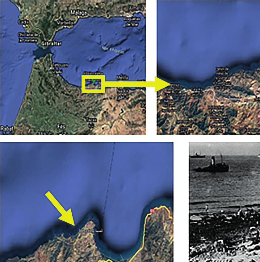
Ecological Engineering & Environmental Technology 2022, 23(5), 218–223

from the famous painter in Valencia Juan De Juanes.      Ajdir (Mazama) as well as several defense struc-
Basic ship’s technical data are shown in Table 3. In     tures to protect coastal towns. As a result, along
March, the mail steamer Juan De Juanes was sunk          with many coastal areas around the world, it is of-
by Riffian canon fire (José De Alvarez, 2001).           ten possible to observe the presence of archaeolog-
                                                         ical remains of different ages (Mattei et al., 2019).
                                                         Furthermore, the Al-Hoceima coast has witnessed
STUDY AREA                                               an important military activity during the colonial
                                                         period, and many Spanish military landings during
     The study area is the Al Hoceima province           the Rif war (Fig. 3b and 3c); consequently, many
coast on the Mediterranean seaboard of Morocco           military ships were sunk. As a result, the Al-Hocei-
(Fig. 3a), between 35.1980 N and 35.1595 N lati-         ma province coast has vast archeological sites and
tude, -3.8230 W and -4.4290 W longitude. It has          most of them have not yet been discovered.
a coast length of approximately 60 kilometers. In
the coastal plains in the Al-Hoceima region, agri-
cultural activities were firstly developed, latterly     MATERIALS AND METHOD
followed by the emplacement of coastal towns and
villages such as Bades in the West of the study area,        For its higher accuracy, faster speed, and
and Ajdir in the East. Related to maritime trans-        less human intervention deep learning has al-
port for the importation/exportation of goods. This      most dominated SAR ship detection community
forced the construction of harbors in Bades and          (Zhang et al., 2020). Recently, ship detection

       Figure 3. a) Location of study area (Google Earth images); b) Spanish forces landing in Sabadiya
          beach (West of study area), Hulton-Deutsch Collection/CORBIS/Corbis via Getty Images©;
            c) Spanish forces landing in Kimado beach (East of study area), el Museo de Ejército©

220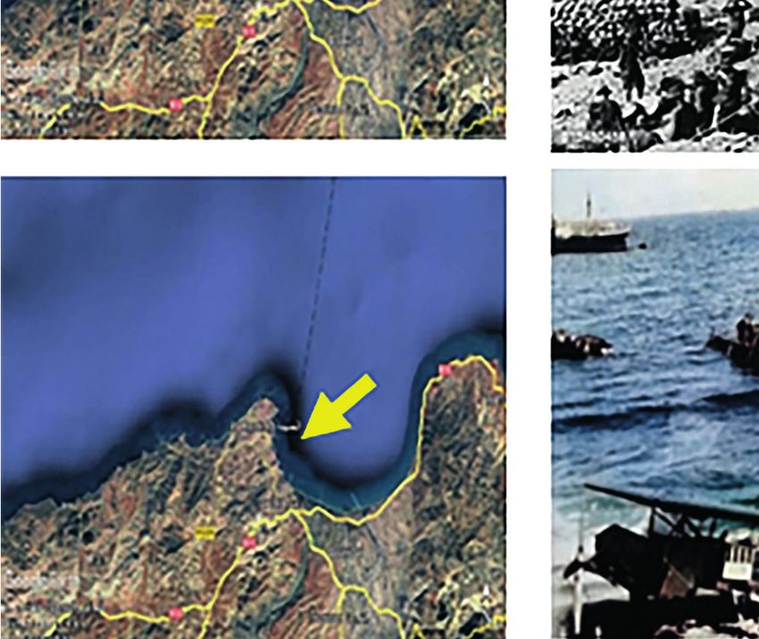
Ecological Engineering & Environmental Technology 2022, 23(5), 218–223
using a synthetic aperture radar (SAR) image mode (Single Look Complex), which is provided
is becoming a fundamental tool in remote sens- by the scientific data Hub (https://scihub.coper-
ing techniques. Therefore, the remote sensing nicus.eu/). To do this, the open-source software
technique has been applied to the free radar im- (SNAP) provided by the European Space Agency
age captured by the sentinel-1 (Table 4) in SLC (ESA) has been used in this study. The image is
Table 4. Sentinel-1 data information of image
ESA Product Dual Date and time of Date and time of end
Mode Orbit number ID product
satellite type polarization start acquisition of acquisition
S1A IW SLC DV 2016-01-21.18:17 2016-01-21.18:18 009596 E82F
Figure 4. Chain processes of sentinel-1 image by using SNAP software
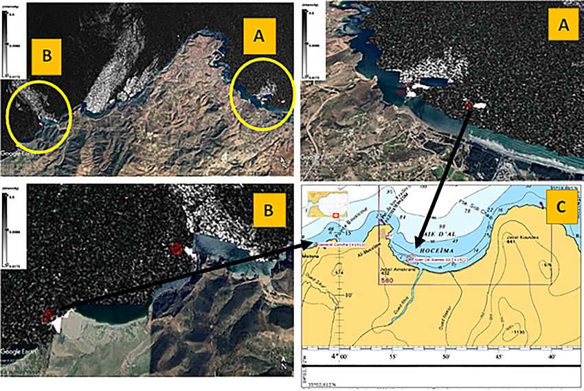
Figure 5. Possible location of shipwrecks in Al-Hoceima coastal; a) three (red points) possible locations of
shipwrecks in the east of study area; b) two (red points) possible locations of shipwrecks in the west of study area;
c) The Map of shipwrecks in Al-Hoceima coastal during the Rif war, Spanish hydrographic institute 2020©. The
arrows indicate the similarity position between possible location of shipwrecks and the map of shipwrecks il Al-
Hoceima coastal during the Rif war
221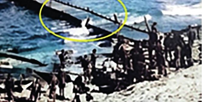
Ecological Engineering & Environmental Technology 2022, 23(5), 218–223

atmospherically corrected. The processing chain            The result obtained using the sentinel 1 image
in Figure 4 has been applied to the image men-         and the SNAP software is very important, but it
tioned above. We focused on the detecting and the      must be noted that the shipwreck’s locations are
mapping of shipwrecks because it has occupied          not very accurate. Indeed, Figure 6 shows where
a predominant role in the research undertaken in       the Juan De Juanes exactly sunk to the right of the
maritime archeology (Reggiannini & Salvetti,           island, whereas Figure 5a shows the location on
2017; Secci et al., 2021).                             the left of the island, so there are dozens of meters
                                                       of incertitude.

RESULT AND DISCUSSION
                                                       CONCLUSION
     The result of this study shows five possible
locations of shipwrecks (Fig. 5) in the study area,        Using sentinel-1 image, and SNAP software
three locations in Al-Hoceima (Fig. 5a) bay and        can provide good quality detection of shipwrecks,
two locations in Bokoya coastal (Fig. 5b). To con-     especially at low depth. In addition, this technique
firm the result obtained, we used data shipwrecks      costs nothing, but before diving for looking the
of the Spanish hydrographic institute (Fig. 5c),       shipwrecks, the results must be verified by other
which confirmed two of these locations. The first      methods. The result obtained show that The Al-
one is the location of the Juan De Juanes frigate,     Hoceima coastal has a huge archaeological site,
which is sinking in Al-Hoceima bay near the Nekor      consisting of ancient shipwrecks, with broad po-
island (Fig. 6). The sinking of the Juan De Juanes     tential for the development of the tourism sector.
frigate was mentioned by Ahmed Chochaib Khat-
tabi Bourjila, he said “The Riffians gunfire sank
the ‘Juan de Juanes’ ship near the Nekor island,       REFERENCES
its payload about 10 thousand tons, and it was
carrying to the island 15 and a half large-caliber     1. Character, L., Ortiz, A., Beach, T., Luzzadder-
guns and other war munitions”. The second loca-           Beach, S. 2021. Archaeologic machine learning
tion is for the General Concha gunboat, which is          for shipwreck detection using lidar and sonar. Re-
sinking in Bokoya coastal, it was mentioned by            mote Sensing, 13(9), 1–15. https://doi.org/10.3390/
Muhammad Aras, nicknamed «Baku», he said “I               rs13091759
was on the Nekor island for shopping, like other       2. Danese, M., Gioia, D., Vitale, V., Abate, N., Amo-
people from my village (Ajdir), while we were             dio, A.M., Lasaponara, R., Masini, N. 2022. Pattern
getting ready to leave the island, two Spanish            Recognition Approach and LiDAR for the Analysis
ships arrived. The soldiers on these two ships said       and Mapping of Archaeological Looting: Applica-
that the Concha ship had collided due to the thick        tion to an Etruscan Site. Remote Sensing, 14(7),
fog. They tried to move the ship into the depths of       1587. https://doi.org/10.3390/rs14071587
the sea, but they couldn’t...” (Abdelhamid Rais,       3. Geraga, M., Christodoulou, D., Eleftherakis, D.,
2016). Whereas the other detected wrecks remain           Papatheodorou, G., Fakiris, E., Dimas, X., Geor-
                                                          giou, N., Kordella, S., Prevenios, M., Iatrou, M.,
still unidentified.
                                                          Zoura, D., Kekebanou, S., Sotiropoulos, M., Fe-
                                                          rentinos, G. 2020. Atlas of Shipwrecks in Inner
                                                          Ionian Sea (Greece): A Remote Sensing Approach.
                                                          Heritage, 3(4), 1210–1236. https://doi.org/10.3390/
                                                          heritage3040067
                                                       4. Gkionis, P., Papatheodorou, G., Geraga, M. 2021.
                                                          The benefits of 3d and 4d synthesis of marine geo-
                                                          physical datasets for analysis and visualisation of
                                                          shipwrecks, and for interpretation of physical pro-
                                                          cesses over shipwreck sites: A case study off metho-
                                                          ni, Greece. Journal of Marine Science and Engineer-
                                                          ing, 9(11). https://doi.org/10.3390/jmse9111255
                                                       5. Grøn, O., Boldreel, L.O., Cvikel, D., Kahanov, Y.,
                                                          Galili, E., Hermand, J.P., Nævestad, D., Reitan, M.
      Figure 6. The sinking of The Juan De Juanes         2015. Detection and mapping of shipwrecks embed-
          frigate, Juan Carlos Diaz Lorenzo©              ded in sea-floor sediments. Journal of Archaeological

222
Ecological Engineering & Environmental Technology 2022, 23(5), 218–223
Science: Reports, 4(February 2018), 242–251. Journal of Cultural Heritage, 24, 147–156. https://
https://doi.org/10.1016/j.jasrep.2015.09.005 doi.org/10.1016/j.culher.2016.10.012
6. Grządziel, A. 2020. Using remote sensing techniques 11. Secci, M., Demesticha, S., Jimenez, C., Papadopou-
to document and identify the largest underwater ob- lou, C., Katsouri, I. 2021. A living shipwreck: An
ject of the baltic sea: Case study of the only ger- integrated three-dimensional analysis for the un-
man aircraft carrier, graf zeppelin. Remote Sensing, derstanding of site formation processes in archaeo-
12(24), 1–23. https://doi.org/10.3390/rs12244076 logical shipwreck sites. Journal of Archaeological
7. Leidwanger, J., Howitt-marshall, D.S. 1978. Ar- Science: Reports, 35(June 2020), 1–11. https://doi.
chaeological applications for remote sensing in the org/10.1016/j.jasrep.2020.102731
coastal waters of Cyprus : the experience of recent 12. Zhang, T., Zhang, X., Ke, X., Zhan, X., Shi, J., Wei,
fieldwork and methodology for the future. S., Pan, D., Li, J., Su, H., Zhou, Y., Kumar, D. 2020.
8. Ødegård, Ø., Sørensen, A.J., Hansen, R.E., Lud- LS-SSDD-v1.0: A deep learning dataset dedicated
vigsen, M. 2016. A new method for underwater ar- to small ship detection from large-scale Sentinel-1
chaeological surveying using sensors and unmanned SAR images. Remote Sensing, 12(18), 1–37. https://
platforms. IFAC-PapersOnLine, 49(23), 486–493. doi.org/10.3390/RS12182997
https://doi.org/10.1016/j.ifacol.2016.10.453 13. Mundo Gráfico, número 85 de 11 de junio de 1913,
9. Papatheodorou, G., Stefatos, A., Christodoulou, D., página 18.
Ferentinos, G. 2001. Remote sensing in submarine ar- 14. Bourjila, A.C. El. The captain and the wars of the
chaeology and marine cultural resources management: Rif. Shop my books, 125.
An ancient shipwreck outside Zakynthos port, Greece. 15. De Alvarez, J. 2001. Contribution in comparative
Proc. of 7th Internatioanl Conference on Environmental colonial studies, 40.
Science and Technology, C, Posters, 377–385. 16. Rais, A. 2016. Testimonies about the resistance
10. Reggiannini, M., Salvetti, O. 2017. Seafloor analy- during the era of the leader Muhammad bin Abdel
sis and understanding for underwater archeology. Karim Al-Khattabi. Tifraz publications.
223You can also read