Delaware Department of Transportation June 2022 - MULBERRY KNOLL ROAD EXTENSION
←
→
Page content transcription
If your browser does not render page correctly, please read the page content below
This page intentionally le ft blank.
MULBERRY KNOLL ROAD EXTENSION

           PLANNING AND ENVIRONMENTAL LINKAGES STUDY

      Delaware Department of Transportation

                       June 2022
MULBERRY KNOLL ROAD EXTENSION
PLANNING AND ENVIRONMENTAL LINKAGES STUDY

                     Prepared for:

        Delaware Department of Transportation
                  Division of Planning
           Regional Systems Planning Section

                          By:

         Whitman, Requardt & Associates, LLP

                      June 2022
Mulberry Knoll Road Extension – Planning and Environmental Linkages Study                                                   June 2022

                                                  Table of Contents
1.0     INTRODUCTION AND BACKGROUND .......................................................................... 1
  1.1     Study Area ................................................................................................................... 1
  1.2     Planning Context and Background ............................................................................... 3
                Federal Requirements .......................................................................................... 3
                State and Regional Planning................................................................................. 4
                Sussex County Planning and Zoning Office .......................................................... 5
2.0     PURPOSE AND NEED ................................................................................................... 5
  2.1     Reduce Congestion for Local and Regional Traffic and Increase System Linkages ..... 6
  2.2     Accommodate Planned and Approved Local Development .........................................10
3.0     EXISTING ENVIRONMENT ...........................................................................................13
  3.1     Land Use ....................................................................................................................13
  3.2     Demographic Characteristics ......................................................................................13
  3.3     Environmental Features ..............................................................................................15
                Parcel Boundary ..................................................................................................15
                Delineated Natural Resources .............................................................................17
                Natural Areas .......................................................................................................17
                Agricultural Lands Preservation ...........................................................................17
                Structure ..............................................................................................................18
                Historic Property ..................................................................................................18
                Federal Emergency Management Agency (FEMA) Flood Zones .........................18
                Nanticoke Indian Tribe State Designated Tribal Statistical Area (SDTSA) ............19
4.0     CONCEPT SCREENING CRITERIA ..............................................................................19
  4.1     Step 1: Does the Concept Meet the Identified Needs of the Project? ..........................19
  4.2     Step 2: Does the Concept Meet Additional Screening Criteria?...................................19
5.0     CONCEPT DEVELOPMENT AND EVALUATION ..........................................................20
  5.1     Concepts Evaluated ....................................................................................................21
                Concept A ............................................................................................................21
                Concept B ............................................................................................................22
                Concept C............................................................................................................22
  5.2     Evaluation of Concepts ...............................................................................................23
  5.3     Direct, Indirect and Cumulative Effects .......................................................................25
  5.4     Conceptual Cost Estimate...........................................................................................26
6.0     PUBLIC INVOLVEMENT AND AGENCY COORDINATION ...........................................26

                                                                                                                                 Page i
Mulberry Knoll Road Extension – Planning and Environmental Linkages Study                                                June 2022

   6.1      Public Involvement ......................................................................................................26
   6.2      Agency Coordination...................................................................................................27
7.0      CONCEPTS RECOMMENDED FOR FURTHER STUDY ...............................................27
8.0      NEXT STEPS .................................................................................................................27
9.0      REFERENCES ...............................................................................................................29

                                                      List of Figures
Figure 1: Study Area Location .................................................................................................... 2
Figure 2: 2017 AM and PM Peak Hour LOS ............................................................................... 8
Figure 3: 2045 AM and PM Peak Hour LOS ............................................................................... 9
Figure 4: Historic Land Use .......................................................................................................11
Figure 5: 2045 Land Use...........................................................................................................12
Figure 6: Census Block Groups within the Study Area ..............................................................14
Figure 7: Environmental Constraints .........................................................................................16
Figure 8: Concept Screening Process Flow Chart .....................................................................19

                                                       List of Tables
Table 1: Total Population and Housing Units ............................................................................. 5
Table 2: Intersection Capacity Summary .................................................................................... 7
Table 3: Existing Land Use within the Study Area .....................................................................13
Table 4: Demographic Profile ....................................................................................................15
Table 5: Intersection Capacity Summary ...................................................................................23
Table 6: Comparison of Concepts .............................................................................................24
Table 7. Past, Present, and Future Actions Within a Five-Mile Radius of the Proposed Mulberry
            Knoll Road Extension Corridor....................................................................................25

                                                                                                                              Page ii
Mulberry Knoll Road Extension – Planning and Environmental Linkages Study      June 2022

                                     List of Appendices
APPENDIX A: Federal Highway Administration – Planning and Environmental Linkages
            Questionnaire
APPENDIX B: Alternatives Mapping
APPENDIX C: Cost Estimate
APPENDIX D: Public Questions & Comments from October 26, 2021, Virtual Public Meeting
APPENDIX E: Resource Agency Review and Comments

                                                                                   Page iii
Mulberry Knoll Road Extension – Planning and Environmental Linkages Study                 June 2022

1.0    INTRODUCTION AND BACKGROUND
The Delaware Department of Transportation (DelDOT) has prepared this Mulberry Knoll Road
Extension Planning and Environmental Linkages (PEL) study to establish a long-term vision and
inform strategic transportation and development planning for future improvements west of SR
1/Coastal Highway in eastern Sussex County between US 9/Lewes Georgetown Highway and
SR 24/John Williams Highway.
The Mulberry Knoll Road Extension PEL study is intended to identify and preserve a defined
corridor for future project implementation and streamline the process for accelerated
environmental analyses. The study will also inform regional transportation priorities in advance of
funding becoming identified for detailed design and construction. PEL studies represent a
collaborative and integrated approach to transportation decision making that considers benefits
and impacts of potential future transportation improvements in comparison to the potential
impacts to the environment, communities, and economy (FHWA, 2016). Information developed
during these early transportation planning efforts can be integrated into the environmental review
process as future funding is identified and a project advances to more detailed stages of
engineering and design. The result of these planning efforts is intended to be an efficient decision-
making process that encourages working relationships between federal, state, and local
government agencies and stakeholders.
This section describes the study area that serves as the focus for this PEL study and provides
background information on the context of the study area and previous associated planning efforts.

1.1    Study Area
This study focuses on the north-south corridor that parallels SR 1 between US 9 and SR 24 and
is generally bounded by SR 1D/Plantation Road to the east and to the west by the residential
developments along Love Creek (see Figure 1). The study area is approximately five miles west
of Rehoboth and Dewey Beaches and just south of the area known as Five Points, at the
intersection of US 9 and SR 1. SR 1 represents one of the most congested areas in Sussex
County, due to its proximity to the beaches, adjacent shopping outlets, and other tourist attractions
(DelDOT, 2017). In addition to the area’s popularity as a tourist destination and for the commercial
development along SR 1, this portion of eastern Sussex County is also an increasingly attractive
area for full-time residents. With commercial development established along SR 1 and residential
growth due to seasonal dwellings as well as people permanently relocating to the area,
development continues to move to undeveloped properties to the south and west of the SR 1
corridor. This continued growth presents challenges for the efficient movement of traffic through
the study area for both residents and visitors during the summer peak season, and increasingly
throughout the remaining months of the year.
The study area encompasses approximately four-square miles with a mix of suburban residential
developments interspersed among farm fields and open space as well as sensitive natural areas
surrounding Love Creek, Goslee Creek, and their tributaries. The study area is characterized by
low-lying areas of the Atlantic Coastal Plain Physiographic Province, with elevations that range
up to 25 feet above mean sea level.

                                                                                              Page 1
Mulberry Knoll Road Extension – Planning and Environmental Linkages Study            June 2022

                                                     Figure 1: Study Area Location

                                                                                       Page 2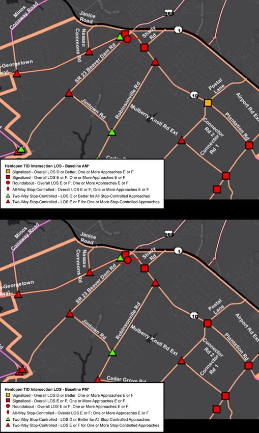
Mulberry Knoll Road Extension – Planning and Environmental Linkages Study                    June 2022

Within the study area, Mulberry Knoll Road is a two-lane, local road with no shoulders and a
posted speed limit of 50 miles per hour (mph). At the southern study limits, Mulberry Knoll Road
intersects SR 24, which is a two-lane, major collector with full shoulders and a posted speed limit
of 45 mph. Mulberry Knoll currently ends at the intersection with Cedar Grove Road, which is a
two-lane, local road with no shoulders with a posted speed limit of 45 mph. Other east-west
roadways within the study area include Robinsonville Road, which is a two-lane, local road with
no shoulders and SR 23/Beaver Dam Road, which is a two-lane, major collector with a posted
speed of 45 mph. US 9, which is at the northern limit of the study, is a two-lane, major collector
with full shoulders and a posted speed limit that varies between 40 and 50 mph. Plantation Road,
which forms the eastern study boundary, is a two-lane, major collector with full shoulders and a
posted speed limit of 45 mph. Along the western portion of the study area, Jimtown Road is a
two-lane, local road with no shoulders and a posted speed limit of 45 mph. Throughout the study
area, there are limited existing bike and pedestrian facilities.
There are multiple active DelDOT projects that include proposed improvements along roadways
within the study area. Contract T200411209, SR 24: Mulberry Knoll to SR 1, is currently under
construction and scheduled to be complete by summer 2022. Contract T201212201, SR 24: Love
Creek to Mulberry Knoll, is scheduled to begin construction in spring 2023. Contract T202011201,
Plantation Road (Phase 1): Robinsonville Road to US 9, is scheduled to begin construction in
summer 2022. Phase 2 improvements along Planation Road will extend from SR 24 to
Robinsonville Road. The Department is still evaluating what the proposed typical section and
future traffic capacity needs will be for this section of Plantation Road.

1.2    Planning Context and Background
The study area and surrounding region has been subject to extensive transportation studies and
improvements since it is one of the fastest growing areas in Delaware that continues to generate
tourism-related trips and year-round trips due to the growing number of permanent residents. The
following provides a brief description of planning efforts and initiatives applicable to this study that
have influenced the inception of this PEL study and identification of the study area.

       Federal Requirements
The transportation planning and programming process and the environmental review process are
long-standing elements that have been required in transportation infrastructure development. The
transportation planning process is required by 23 United States Code (USC) §134 and 135.
Furthermore, federal law (23 USC §168) calls for the integration of planning decisions, such as
the identification of a general travel corridor, and the environmental review process. This was
explicitly clarified in the Safe, Accountable, Flexible, Efficient Transportation Equity Act: A Legacy
for Users (SAFETEA-LU) and Moving Ahead for Progress in the 21st Century (MAP-21)
reinforced and expanded this authority. Federal regulation also strongly supports the integration
of the transportation planning process with the National Environmental Policy Act of 1969 (NEPA)
environmental review process. Supporting the increased use of synchronized planning efforts and
environmental review processes, FHWA has developed a standard PEL Questionnaire to ensure
that planning information and decisions are properly documented to be utilized in future federal
approvals, such as decision making under NEPA. The completed standard PEL Questionnaire
for the Mulberry Knoll Road Extension study is included in Appendix A.

                                                                                                Page 3
Mulberry Knoll Road Extension – Planning and Environmental Linkages Study                June 2022

       State and Regional Planning
Recognizing the increasing travel demand pressures of the study area, DelDOT began exploring
opportunities and solutions to effectively manage the transportation system and land use for the
Rehoboth and Lewes area with the completion of the SR 1 Land Use and Transportation Study
in August 2003 (DelDOT, 2003). Conducted in collaboration with Sussex County, the study
identified a few possible recommendations to address the travel demand and land use
development challenges within the area, including short- to mid-term solutions such as signal
optimization and intersection improvements along SR 1. Additionally, the study identified potential
long-term improvements that were recommended for further study, evaluation, and eventual
implementation. Among these concepts were an access-controlled parkway west of SR 1 or
widening of Plantation Road and SR 24 to improve capacity and local circulation.
Following the recommendations of the SR 1 Land Use and Transportation Study, DelDOT initiated
the planning and project development process to examine a full range of alternatives for providing
a new transportation corridor west of SR 1. This planning effort was captured in the Western
Parkway Study, which began in 2004 and was intended to identify, select, and preserve a
transportation corridor for the future implementation of a four-lane north-south roadway between
Lewes/Five Points and destinations along SR 24. Through the evaluation of several alternative
alignments, it became apparent that the public and residents were concerned about potential
property impacts, along with developers who had purchased land in the conceptual rights-of-way,
and the Western Parkway Study did not advance.
More recently, DelDOT and Sussex County agreed to establish the Henlopen Transportation
Improvement District (DelDOT, 2020a [TID]) to develop cohesive transportation and land use
strategies southwest of SR 1. In 2018, DelDOT completed the Henlopen TID Existing Conditions
Traffic Analysis Report (DelDOT, 2018b) which subsequently identified several projects that are
either included or may be proposed for inclusion in DelDOT’s Capital Transportation Program
(CTP). These projects include innovative intersection improvements as well as widening
Plantation Road and a new connector extending Mulberry Knoll Road from SR 24 to US 9
(DelDOT, 2020b).
Concurrently with the Henlopen TID study, DelDOT and Sussex County partnered with residents,
business community members, elected officials, and agency representatives to create the Five
Points Transportation Study Working Group. The Working Group was tasked with developing
recommendations to improve local traffic circulation at Five Points and in the surrounding area
and, through a series of meetings and coordination from December 2017 through October 2018,
identified a few needs, recommendations, and priorities for transportation improvements in the
region.
The Five Points Transportation Study – Phase I Final Report provides a prioritized list of these
recommendations (DelDOT, 2018a) and the Working Group has since transitioned the study into
Phase II to monitor and direct plan implementation. As a result of the collaborative efforts of the
Working Group, several projects, at varying stages of planning, design, and construction, have
advanced. These projects include:

   •   SR 1, Rehoboth Canal to north of Five Points pedestrian sidewalks
   •   SR 24, Mulberry Knoll to SR 1 widening to four lanes
   •   SR 1, Minos Conaway Road grade-separated intersection

                                                                                            Page 4
Mulberry Knoll Road Extension – Planning and Environmental Linkages Study                                           June 2022

      •   Old Orchard Road, Wescoats Road intersection realignment
Among the recommendations for new infrastructure investment to support future anticipated
growth, the Five Points Transportation Study – Phase I Final Report also identified the evaluation
of a new road parallel to Plantation Road, connecting Mulberry Knoll Road to US 9, which served
as the impetus for the Mulberry Knoll Road Extension PEL study.

          Sussex County Planning and Zoning Office
In addition to their integral role in regional transportation planning, Sussex County recognizes the
importance of providing capacity improvements and implementing coordinated approaches to
land use and transportation development. The Sussex County Comprehensive Plan recommends
additional capacity improvement projects between US 9 to SR 24, west of Lewes and Rehoboth
Beach (Sussex County, 2019).

2.0       PURPOSE AND NEED
This section defines the Purpose and Need for the study, which establishes the critical framework
for identifying transportation solutions to be evaluated in the study area. Consistent with historic
trends in Sussex County, the study area for the Mulberry Knoll Extension PEL Study has
experienced continued growth and development at a substantial rate, resulting in increased traffic
volumes on the local roadway network. Table 1 shows the historic trends for population and
housing data in the study area, compared to Delaware and Sussex County. Between 2000 and
2018, the study area has exhibited a higher growth rate in total population and housing units as
compared to the averages of Delaware and Sussex County. From 2000 to 2018, the study area’s
population grew by 84 percent; similarly, the total number of housing units in the study area
increased by 72 percent. Sussex County’s growth was substantially lower, at 50 percent and 46
percent respectively, and statewide rates were lower yet at 24 percent and 23 percent.
                                   Table 1: Total Population and Housing Units

                                   2000                      2010                      2018               %Δ 2000 - 2018
                                                     Total Population
 Delaware               783,600                          897,934                     973,764                     24%
    %Δ From Previous Analysis Year                         15%                         8%                          -
 Sussex County          156,638                          197,145                     234,225                     50%
    %Δ From Previous Analysis Year                         26%                        19%                          -
 Study Area              13,742                           18,882                     25,230                      84%
    %Δ From Previous Analysis Year                         37%                        34%                          -
                                                      Housing Units
 Delaware               343,072                          405,885                     428,251                     25%
    %Δ From Previous Analysis Year                         18%                         6%                          -
 Sussex County           93,070                          123,036                     135,529                     46%
    %Δ From Previous Analysis Year                         32%                        10%                          -
 Study Area              9,748                            14,397                     16,801                      72%
    %Δ From Previous Analysis Year                         48%                        17%                          -
 Sources: U.S. Census Bureau, 2000 (DEC Summary File [Tables P001 and H001]); U.S. Census Bureau, 2012 (Table 1); and
 U.S. Census Bureau, 2019 (Detailed Tables [Tables S0101 and B25001])
 Note: Study area calculation includes Census Tracts within or adjacent to study area (Census Tracts 508.02, 510.04, 510.05,
 510.06, 510.07 and equivalent geographical areas [Census Tracts 508.2, 510.01, and 510.02] for 2000 Census)

                                                                                                                        Page 5
Mulberry Knoll Road Extension – Planning and Environmental Linkages Study June 2022
In the study area and surrounding vicinity, this population growth and development is expected to
continue. The Delaware Population Consortium (DPC), which is comprised of representatives
from state agencies, regional planning organizations, and localities, annually prepares a set of
30-year population projections for the state, counties, and selected municipalities. Based on the
DPC’s latest population and housing forecasts, the population in Sussex County is expected to
grow to 285,658 by 2050 (an increase of 22 percent from 2018). Similarly, housing units in Sussex
County are expected to increase by 23 percent to 166,226 by 2050, compared to 2018 (135,529)
(DPC, 2019). As the population and development in the study area continues to grow, efficient
traffic movement through the study area will remain a challenge for residents as well as visitors.
The purpose of the Mulberry Knoll Extension PEL Study is to identify transportation improvements
that will reduce congestion for local and regional traffic and increase system linkages, while
improving access to designated development areas to support economic vitality and sustained
growth in the study area. Following is a description of each of the needs that have been identified
for the study area.
2.1 Reduce Congestion for Local and Regional Traffic and Increase System Linkages
Table 2 shows the existing and projected capacity analyses within the study area, represented
by the overall Level of Service (LOS)1 for signalized and unsignalized intersections within the
study area. Existing conditions are listed based on 2017 traffic data, derived from the Henlopen
TID Study, which included seasonal adjustments and adjustments to account for specific
development sites and employment that had occurred since the traffic data were collected
(DelDOT, 2018b). As listed in Table 2 and shown in Figure 2, six of the 16 intersections analyzed
in the study area currently operate with volumes at or exceeding the capacity of the roadway
system, resulting in stoppages and delays for long periods of time. LOS F operations indicate
volumes exceeding capacity on multiple approaches to an intersection with motorists waiting
through multiple signal cycles to travel through the intersection. During LOS F conditions, queues
will continue to grow throughout the duration of at-capacity conditions, extend beyond the turn
lanes, and cause blockages of upstream intersections and access points.
The Henlopen TID Study forecasted LOS for 2045 assuming the implementation of all committed
transportation improvement projects in the study area that are included in DelDOT’s Capital
Transportation Program (CTP) for Fiscal Years (FY) 2019-2024 and developer commitments as
of May 2018 (DelDOT, 2020c). By 2045, LOS in the study area is expected to worsen compared
to existing conditions, with 13 of the 16 intersections analyzed in the study area expected to
operate at or beyond capacity (see Figure 3) (DelDOT, 2020c). Operational improvements along
Plantation Road from SR 24 to US 9, including turn lanes and other intersection modifications,
median turn lanes for residential entrances, and bicycle and pedestrian facilities along the
corridor, are included among the programmed projects assumed under the 2045 analysis
scenario. Even with the implementation of these improvements, the operational conditions of the
study area are expected to be degraded, as noted in Table 2, and will not meet the LOS minimum
of D, as set in the TID Agreement (DelDOT 2020a). This demonstrates a need for additional
improvements in the study area to improve congestion and increase system linkages.
1 LOS is a qualitative measure of operational conditions based on criteria such as speed, travel delay, freedom to
maneuver, traffic interruptions, comfort, and convenience. LOS A reflects free flow traffic conditions with minimal delays
and vehicles unimpeded in their ability to maneuver, whereas LOS E or LOS F reflects traffic volumes at or exceeding
the capacity of the roadway system resulting in stoppages and delays for long periods of time.
Page 6Mulberry Knoll Road Extension – Planning and Environmental Linkages Study June 2022
Table 2: Intersection Capacity Summary
Intersection 2017 2045
Intersection
Type
AM PM AM PM
US 9/Lewes Georgetown Hwy LOS D or
Signalized LOS E or F LOS E or F LOS E or F
at SR1/Coastal Hwy Better
US 9/Lewes Georgetown Hwy LOS D or LOS D or LOS D or
Signalized LOS E or F
at Belltown Rd Better Better Better
Two-Way
Belltown Rd at SR 23/Beaver LOS D or LOS D or
Stop- LOS E or F LOS E or F
Dam Rd Better Better
Controlled*
Two-Way
US 9/Lewes Georgetown Hwy LOS D or
Stop- LOS E or F LOS E or F LOS E or F
at Nassau Commons Blvd Better
Controlled
Two-Way
US 9/Lewes Georgetown Hwy LOS D or LOS D or
Stop- LOS E or F LOS E or F
at Minos Conaway Rd Better Better
Controlled
Two-Way
SR 23/Beaver Dam Rd at LOS D or LOS D or
Stop- LOS E or F LOS E or F
Jimtown Rd Better Better
Controlled
Two-Way
LOS D or LOS D or LOS D or LOS D or
Jimtown Rd at Robinsonville Rd Stop-
Better Better Better Better
Controlled
Two-Way
Robinsonville Rd at Cedar LOS D or LOS D or LOS D or
Stop- LOS E or F
Grove Rd Better Better Better
Controlled
Two-Way
LOS D or LOS D or LOS D or LOS D or
Cedar Grove Rd at Ward Rd Stop-
Better Better Better Better
Controlled
Two-Way
Cedar Grove Rd at Mulberry LOS D or LOS D or
Stop- LOS E or F LOS E or F
Knoll Rd Better Better
Controlled
SR 24/John J Williams Hwy at LOS D or LOS D or
Signalized LOS E or F LOS E or F
Beacon Middle School Better Better
Two-Way
SR 24/John J Williams Hwy at
Stop- LOS E or F LOS E or F LOS E or F LOS E or F
Mulberry Knoll Rd
Controlled
SR 24/John J Williams Hwy at LOS D or
Signalized LOS E or F LOS E or F LOS E or F
SR1D/Plantation Rd Better
SR 1D/Plantation Rd at Cedar LOS D or LOS D or LOS D or
Signalized LOS E or F
Grove Rd Better Better Better
Two-Way
SR 1D/Plantation Rd at LOS D or LOS D or
Stop- LOS E or F LOS E or F
Robinsonville Rd Better Better
Controlled
SR 1D/Plantation Rd at Shady LOS D or
Signalized LOS E or F LOS E or F LOS E or F
Rd Better
Sources: DelDOT, 2018b and 2020c
Page 7Mulberry Knoll Road Extension – Planning and Environmental Linkages Study June 2022
Figure 2: 2017 AM and PM Peak Hour LOS
Source: DelDOT, 2018b
Source: DelDOT, 2018b
Page 8Mulberry Knoll Road Extension – Planning and Environmental Linkages Study June 2022
Figure 3: 2045 AM and PM Peak Hour LOS
Source: DelDOT, 2020c
Source: DelDOT, 2020c
Page 9Mulberry Knoll Road Extension – Planning and Environmental Linkages Study June 2022
2.2 Accommodate Planned and Approved Local Development
Eastern Sussex County has been one of the most rapidly growing parts of Delaware for many
years. Since the early 2000s, land use under commercial and residential development has
increased by over 26 percent, as illustrated in Figure 4. Nearly the entire study area is zoned to
allow for single- or multi-family dwelling units on individual lots, so the continued increase of
development, particularly in the residential sector, is anticipated into the future. Adapted from the
Henlopen TID study, Figure 5 shows the parcels and anticipated number of residential units and
commercial square footage expected within the study area vicinity by 2045. To support current
and future growth in the area, improved access and increased roadway capacity is needed within
the study area. This need is also identified in the Sussex County Comprehensive Plan, which
recommends an improved or new connector road for local traffic west of Lewes and Rehoboth
Beach between US 9 and SR 24 (Sussex County, 2019).
Page 10Mulberry Knoll Road Extension – Planning and Environmental Linkages Study June 2022
Figure 4: Historic Land Use
Page 11Mulberry Knoll Road Extension – Planning and Environmental Linkages Study June 2022
Figure 5: 2045 Land Use
Page 12Mulberry Knoll Road Extension – Planning and Environmental Linkages Study June 2022
3.0 EXISTING ENVIRONMENT
3.1 Land Use
As previously noted, the study area for the Mulberry Knoll Road Extension PEL Study is
comprised of a mix of suburban residential land uses interspersed among farm fields and open
space as well as sensitive natural areas surrounding Love Creek, Goslee Creek, and their
tributaries. Figure 4 illustrates the existing land use within the study area. Of the approximately
2,762 acres within the study area, the land use with the highest percentage is currently agricultural
use (1,505 acres or 54 percent). Residential developments comprise the second most prevalent
land use within the study area (585 acres or 21 percent). Table 3 lists the composition of existing
land use within the study area.
Table 3: Existing Land Use within the Study Area
Land Use Acres Percent Study Area
Agricultural 1,505 54%
Residential 585 21%
Forest 291 11%
Wetlands 203 7%
Other 68 2.5%
Mixed Use 60 2%
Commercial 21 1%
Water 29 1%
Study Area Total 2,762 100%
3.2 Demographic Characteristics
This study area has been evaluated in accordance with Title VI of the Civil Rights Act of 1964, as
amended, which requires that no person in the United States shall on the ground of race, color,
or national origin, be excluded from participation in, be denied benefits of, or be subjected to
discrimination under any program or activity receiving federal financial assistance. In addition,
Executive Order 12898, Federal Actions to Address Environmental Justice in Minority Populations
and Low-Income Populations, and the U.S. Department of Transportation Order 5610.2C direct
federal agencies to identify and address disproportionately high and adverse human health or
environmental effects that their programs, policies and activities may have on minority and low-
income populations to the greatest extent practicable while ensuring EJ communities are
proactively provided meaningful opportunities for public participation in project development and
decision-making.
The study area for the Mulberry Knoll Road Extension PEL Study encompasses portions of four
Census Block Groups, demarcated by the U.S. Census Bureau. Much of the study area is within
Block Group 2, Census Tract 508.02 and is bordered by adjoining block groups (see Figure 6).
Consistent with the guidance noted above, the study area was evaluated to determine if
Environmental Justice communities, which include minority or low-income populations, are
present. Census block groups with high percentages of minority persons and/or high percentages
of families in poverty were identified using the 2015-2019 American Community Survey (ACS) 5-
Year Estimates data from the U.S. Census Bureau. None of the four block groups within the study
area had a higher percentage of minority population as compared to the percentage within Sussex
County (28%).
Page 13Mulberry Knoll Road Extension – Planning and Environmental Linkages Study June 2022
Figure 6Block Groups within the Study Area
Page 14Mulberry Knoll Road Extension – Planning and Environmental Linkages Study June 2022
However, one of the block groups, Census Tract 508.02, Block Group 2, had a much higher
percentage of families in poverty (19%) as compared to the percentage with Sussex County (7%).
Although not reflected in the Census data, the unincorporated community of Jimtown, an historic
African American community, is located within the northwest portion of the study area.
Additionally, the Nanticoke Indian Tribe State Designated Tribal Statistical Area (SDTSA) is
located within the study area. SDTSAs are statistical geographic areas identified and delineated
for state recognized tribes that are not federally recognized and do not have an American Indian
reservation or off-reservation trust land. The Census Bureau works with an appointed state liaison
to delineate statistical areas for state-recognized tribes. SDTSAs provide state recognized tribes
without reservations statistical data for a geographic area that encompasses a substantial
concentration of tribal members (Census, 2021).
Table 4 provides a demographic profile of block groups contained within the study area,
compared to Sussex County and Delaware.
Table 4: Demographic Profile
Census Tract 508.02 510.04 510.06 Study Sussex
Delaware
Block Group 2 1 2 1 Area County
Total Population 4,105 3,115 2,429 1,551 11,200 234,225 973,764
% Pop. Under Age 5 8% 5% 1% 3% 5% 5% 6%
% Pop. 65 and Over 22% 37% 40% 35% 32% 26% 18%
Minority Population (1) 963 596 217 212 1,988 66,025 377,267
% Minority Pop. (1) 23% 19% 9% 14% 18% 28% 32%
Total Families 1,179 910 621 732 3,442 62,686 240,038
Families in Poverty 228 26 30 42 326 4,662 18,981
% in Poverty 19% 3% 5% 6% 9% 7% 8%
Source: U.S. Census Bureau (2019). American Community Survey 5-year Estimates (2015-2019).
Notes: (1) Minority population includes all races that are not Non-Hispanic White Alone; block groups with percentages of families
in poverty greater than the percentages in Sussex County are highlighted in red.
3.3 Environmental Features
To inform the planning-level design and development of conceptual transportation corridors for
consideration in the Mulberry Knoll Road Extension PEL Study, environmental features and
constraints were identified. Within the overall study area, the identification of environmental
resources was primarily focused on an overall corridor in which a future connection could likely
be implemented, considering the existing development and general environmental constraints
within the study area vicinity. Developed in coordination with DelDOT, this field inventory boundary
represents the area within which a physical site investigation occurred to inform a detailed
understanding of the potential environmental constraints that may influence the development of
a future new roadway alignment. Environmental constraints and identified resources are
illustrated in Figure 7 and described below.
Parcel Boundary
Based on geographic information system (GIS) data obtain from Sussex County, Delaware, this
feature represents individual property boundaries within the project vicinity. Properties potentially
impacted by any future new roadway alignment would require conversion of any private property
to public transportation use. As a result, affected property owners would receive fair compensation
for any acquisition or easements of private properties to be incorporated into the roadway right of
way.
Page 15Mulberry Knoll Road Extension – Planning and Environmental Linkages Study June 2022
Figure 7: Environmental Constraints
Page 16Mulberry Knoll Road Extension – Planning and Environmental Linkages Study June 2022
Delineated Natural Resources
Within the Field Inventory Area, a field delineation of jurisdictionally regulated wetlands and
streams was conducted in October 2020, in accordance with the 1987 U.S. Army Corps of
Engineers’ Wetlands Delineation Manual and the Regional Supplement to the Corps of Engineers
Wetland Delineation Manual: Atlantic and Gulf Coastal Plain Region (Version 2.0). A routine on-
site inspection procedure was followed for making wetland determinations and the boundaries of
each feature were delineated using sequentially numbered pink ribbon/pin flags in the field and
each flag was located using global positioning system (GPS) equipment capable of sub-meter
accuracy. Each wetland or waters identified within the field inventory area have been classified
per the U.S Fish and Wildlife Service’s (USFWS) Classification of Wetlands and Deepwater
Habitats of the United States.
Palustrine-Forested (PFO) Wetlands
Of the delineated wetlands, Palustrine-Forested (PFO) wetlands were primarily identified within
the Field Inventory Area. PFO wetlands are nontidal wetlands bound by upland areas and
dominated by trees. PFO wetlands are regulated resources that require a permit for potential
impacts and may require compensation, depending on the degree and extent of impacts. As a
result, impacts to these features should be avoided or minimized to the extent practicable.
Open Water
Impacts to open water are also regulated, require a permit, and may require compensation,
depending on the degree and extent of impacts. Conversely compared to PFO wetlands, if
required, compensation for unavoidable impacts to open water is typically commensurate with the
amount of impact. To the extent practicable, impacts to these features should be avoided or
minimized.
Stream
Streams are also natural resource features identified within the Field Inventory Area that may
convey surface water or groundwater discharge ephemerally, intermittently, or perennially and
demonstrate bed and bank or an ordinary high water mark. These regulated resources may
require structural roadway improvement (i.e., bridge or culvert) to convey continued surface flow
or base flow and may require compensation for potential impacts, based on the degree and extent
of the impact.
Natural Areas
In 1978, the State of Delaware enacted the Natural Areas Preservation System (7 Del. Code,
Chapter 73) for the purpose of establishing an inventory of natural areas statewide and a system
of nature preserves. A "natural area" as defined by the law is an "area of land or water, or of both
land and water, whether in public or private ownership, which either retains or has reestablished
its natural character (although it need not be undisturbed), or has unusual flora or fauna, or has
biotic, geological, scenic or archaeological features of scientific or educational value".
Agricultural Lands Preservation
The Delaware Department of Agriculture manages Delaware’s Agricultural Lands (Aglands)
Preservation Program. This program, established in 1991, allows landowners to voluntarily
preserve their farms. Resources identified under the Aglands Preservation Program are noted to
distinguish where landowners have agreed to use their land for agricultural purposes under a ten-
year agreement. Termination or transfer of this agreement may require coordination with the
Page 17Mulberry Knoll Road Extension – Planning and Environmental Linkages Study June 2022
Agricultural Lands Preservation Foundation, established under the Delaware Department of
Agriculture.
Structure
Based on a review of aerial photography, existing structures have been identified. Similar to any
affected property owners, any structures acquired or relocated would be compensated for the fair
market value, in accordance with the Uniform Relocation Assistance and Real Property
Acquisition Policies Act of 1970 (as amended).
Historic Property
Previously identified historic properties and extant structures have been mapped, based on a
review of the Delaware Division of Historical and Cultural Affairs’ (DHCA) Cultural and Historic
Resource Information System (CHRIS). Based on the information obtained from CHRIS, these
resources are either those that have been identified as eligible or are currently listed on the
National Register of Historic Places (NRHP) as well as existing structures that have been
previously evaluated by DHCA and remain intact. Coordination with the State Historic
Preservation Officer (SHPO), DHCA, would be required to verify the eligibility of these previously
identified historic resources and determine the potential degree of effect as well as any mitigation
that may be required, should any of these properties be impacted. There are no previously
identified archaeology sites within the study area. An archaeological survey was not conducted
as part of this identification effort.
Federal Emergency Management Agency (FEMA) Flood Zones
Digital floodplain data were obtained from the Federal Emergency Management Agency (FEMA)
and overlaid in GIS to determine where 100-year and 500-year floodplains are present in the
project vicinity. The floodplain areas identified are land areas susceptible to being inundated by
floodwaters from any source. Several Federal directives regulate construction in floodplains to
ensure that consideration is given to avoidance and mitigation of adverse effects to floodplains.
These Federal directives include the National Flood Insurance Act of 1968, EO 11988 (May 24,
1977), EO 13690 (January 30, 2015), and USDOT Order 5650.2, entitled Floodplain Management
and Protection. The National Flood Insurance Act of 1968 established the National Flood
Insurance Program (NFIP), which is administered by FEMA. The design for any roadway
improvements would be subject to Federal policies and procedures for the location and hydraulic
design of highway encroachments on floodplains contained in 23 CFR §650 Subpart A. These
features have been identified to inform the planning and design for future roadway improvements
to ensure that there would be no increase in flood levels nor the probability of flooding or the
potential for property loss and hazard to life.
Floodway
The floodway represents the area that encounters the deepest water and the highest velocities.
100-year Flood Hazard
The 100-year flood, or base flood, is the area covered by a flood that has a one percent chance
of occurring in any given year; this is commonly referred to as the 100-year floodplain. The 100-
year floodplain includes the floodway as well as the flood fringe.
500-year Flood Hazard
The 500-year floodplain is the area covered by a flood that has a 0.2 percent chance of occurring
in any given year.
Page 18Mulberry Knoll Road Extension – Planning and Environmental Linkages Study June 2022
Nanticoke Indian Tribe State Designated Tribal Statistical Area (SDTSA)
SDTSAs are statistical geographic areas identified and delineated for state recognized tribes that
are not federally recognized and do not have an American Indian reservation or off-reservation
trust land.
4.0 CONCEPT SCREENING CRITERIA
Concepts that could potentially address the Purpose and Need for the study were developed and
then screened following the two-step process illustrated in Figure 8.
Figure 8: Concept Screening Process Flow Chart
4.1 Step 1: Does the Concept Meet the Identified Needs of the Project?
The Purpose and Need for the Mulberry Knoll Road Extension PEL Study was the primary
criterion in the development of potential concepts to address the identified transportation needs.
The ability of a concept to meet the Purpose and Need was be assessed based on the following
screening criteria:
• Reduce congestion for local and regional traffic and increase system linkages – The
concept was evaluated by comparing the forecasted LOS within the study area outlined
above with anticipated future conditions if the concept was implemented. Based on this
comparison, the concept design would reduce congestion for local and regional traffic and
increase system linkages; thereby meeting the identified need for the project.
• Accommodate planned and approved local development – As shown in Figure 5,
there are many properties identified within the study area for future development. To
accommodate planned and approved development and enable access and improve
circulation, the number of properties identified for future development adjacent to the
alignment should be maximized.
4.2 Step 2: Does the Concept Meet Additional Screening Criteria?
In addition to consideration of the Purpose and Need and input from the public and agencies,
concepts that meet the needs of the project were evaluated based on the following screening
criteria and other factors relevant to evaluating the reasonableness of concepts.
Page 19Mulberry Knoll Road Extension – Planning and Environmental Linkages Study June 2022
• Minimize Right of Way Impacts / Displacements – Widening an existing roadway and
constructing a new roadway would require right of way takings and could require the
displacement of existing residences or businesses. While takings and displacements are
unavoidable, care should be taken to minimize property impacts. Reducing these impacts
also helps to reduce the cost of the project.
• Minimize Impacts to Natural Resources – US Environmental Protection Agency (EPA)
404(b)(1) Guidelines state that “no discharge of dredged or fill material shall be permitted
if there is a practicable alternative to the proposed discharge which would have less
adverse impact on the aquatic ecosystem, so long as the alternative does not have other
significant adverse environmental consequences.” The Guidelines further state that an
“alternative is practicable if it is available and capable of being done after taking into
consideration cost, existing technology, and logistics in light of overall project purposes.”
Therefore, impacts to wetlands, open waters, and streams should be minimized to the
greatest extent practicable, while taking into consideration constructability, cost, and the
overall purpose and need. In addition, impacts to forests, designated agricultural lands,
and designated natural areas should be minimized in accordance with the Delaware
Forest Conservation Act (Delaware State Senate Bill #324), Delaware’s Agricultural Lands
Preservation Program, and the 1978 National Areas Preservation System (7 Del. Code,
Chapter 73).
• Minimize Impacts to Environmental Justice Communities – Executive Order 12898,
Federal Actions to Address Environmental Justice in Minority Populations and Low-
Income Populations (1994) seeks to ensure federal programs do not result in
disproportionately high and adverse environmental or health impacts to minority
populations and low-income populations. Additionally, consistent with Title VI of the Civil
Rights Act of 1964 which prohibits discrimination on the basis of race, color, or national
origin in programs and activities receiving federal financial assistance, DelDOT is
committed to ensuring that no person is excluded from, denied the benefits of, or
discriminated against in their programs and activities based on race, color, or national
origin. Therefore, potential impacts to low-income or minority populations or communities
identified within the study area should be avoided or minimized. Low-income or minority
populations or communities may be identified through minority population or household
income data maintained by U.S. Census Bureau or through coordination with agencies,
localities, organizations, and businesses as well as public outreach.
• Minimize Impacts to Historic Properties – Section 106 of the National Historic
Preservation Act of 1966, as amended (NHPA) requires federal agencies to consider a
project’s effect on historic properties and seek ways to avoid, minimize or mitigate any
adverse effects on historic properties.
• Minimize Cost – A planning-level cost estimate was developed in standard DelDOT
format. Cost may be used as a screening parameter for comparing concepts relative to
others that address the identified Purpose and Need.
5.0 CONCEPT DEVELOPMENT AND EVALUATION
As part of the development of DelDOT’s Mulberry Knoll Road Extension PEL Study, potential
concepts that address the Purpose and Need have been identified and evaluated to generate
possible transportation solutions that could be considered as part of future local development
Page 20Mulberry Knoll Road Extension – Planning and Environmental Linkages Study June 2022
plans and approvals. The development and evaluation of these concepts was focused on an
overall corridor in which a future connection could likely be implemented, considering the existing
development and general environmental constraints within the study area and vicinity.
The development of concepts focused on the extension of Mulberry Knoll Road from Cedar Grove
Road to US 9/Lewes Georgetown Highway. An additional roadway connection in this location
would serve to reduce congestion and increase system linkages within the study area network.
The corridor within which alignment concepts were developed is generally bound by existing
residential developments to the east and west. The conceptual typical section for the new
roadway alignment would include two 11-foot lanes with five-foot-wide shoulders, a 5-foot buffer,
and a 10-foot shared use path on both sides of the roadway. The assumed right-of-way is a
corridor approximately 120 feet wide. This would accommodate anticipated grading requirements,
stormwater conveyance, potential construction access, and future maintenance.
The following sections describe the concepts developed for consideration and provide a
preliminary evaluation of each concept. Unless otherwise noted, the horizontal alignments for
these concepts were developed assuming a 45-mph design speed, using engineering standards
established by the American Association of State Highway and Transportation Officials
(AASHTO) and set forth in the 7th edition of its Policy on Geometric Design of Highways and
Streets (Green Book). A 45-mph design speed was determined to be consistent with the
surrounding local roads. This design speed is also consistent with the Purpose and Need to
accommodate planned and approved local development while providing a safe speed to support
current and future growth in the area. The locations of roundabouts proposed in each concept
were evaluated in accordance with DelDOT Design Guidance Memorandum Number 1-26.
Graphics showing the concepts and the assumed typical section are included in Appendix B.
5.1 Concepts Evaluated
Concept A
Concept A is approximately 2.24 miles in length and is the westernmost alignment concept
developed, which is intended to align with existing parcels owned by DelDOT and to minimize
impacts to private property. Concept A would begin with a new roundabout where Mulberry Knoll
Road intersects Cedar Grove Road. The 2045 LOS analysis (DelDOT, 2020c) for this existing
two-way, stop-controlled intersection indicate conditions of LOS E or F during peak AM and PM
hours. With the construction of a new roundabout, operational conditions will improve to LOS D
or better.
From Cedar Grove Road, the alignment of Concept A would extend northward from Mulberry
Knoll Road and shift slightly west to align with the available right-of-way parcel owned by DelDOT
and avoid the open water quarry ponds. The alignment would follow along the eastern edge of
the Estates of Bridle Ridge neighborhood to avoid private property impacts to that neighborhood,
and then shift farther west as it approaches Robinsonville Road to help minimize impacts to the
single-family residences at 18465 and 18442 Robinsonville Road. At the intersection of the
Concept A alignment and Robinsonville Road, a roundabout is proposed to maintain LOS D
conditions or better. To minimize the impacts to the Robinsonville Road residences, the approach
angle of Concept A at the intersection of Robinsonville Road would require a slight realignment
of the existing Robinsonville Road through the roundabout.
North of Robinsonville Road, Concept A would continue along as far west as possible to avoid
the Agriculture Preservation District, minimize bisecting farmland, and avoid unusable right-of-
Page 21Mulberry Knoll Road Extension – Planning and Environmental Linkages Study June 2022
way remnants. Concept A would then cross the Norwood-Jackson Agricultural Complex, also
along the western edge, to minimize impacts within the historic property boundary to the extent
practicable.
North of the Norwood-Jackson Agricultural Complex, Concept A would cross Beaver Dam Road
and shift east to align with the existing intersection of US 9 and Old Vine Boulevard, where
Concept A would terminate. Both intersections of Concept A at Beaver Dam Road and US 9 are
proposed to be signalized at-grade crossings to maintain LOS D conditions or better.
As shown in Table 6, while avoids impacts to the Agricultural Preservation District and minimizes
impacts to the Norwood-Jackson Agricultural Complex, Concept A is the longest of the three
concepts and affects more parcels and acres of agricultural land compared to the other two
concepts.
Concept B
Concept B follows a similar alignment as Concept A but would be a slightly shorter route
(approximately 2.19 miles in length) due to having fewer curves. Concept B would begin at the
intersection Mulberry Knoll Road and Cedar Grove Road and would also involve the construction
of a new roundabout at this intersection to provide LOS D conditions or better.
From Cedar Grove Road, the alignment of Concept B would extend northward from Mulberry
Knoll Road and shift slightly west to align with the available right-of-way parcel owned by DelDOT
and avoid open water quarry ponds. Approaching Robinsonville Road, the alignment would shift
slightly west to avoid impacts to the residences at 18465 and 18442 Robinsonville Road. At the
intersection of the Concept B alignment and Robinsonville Road, a roundabout is proposed to
maintain LOS D conditions or better. On the south side of this intersection, the alignment would
meet Robinsonville Road at an angle, while on the north, the alignment would be perpendicular
to Robinsonville Road. The alignment would then continue along the existing western property
line of the Agricultural Preservation District to avoid impacts to the farmland. After crossing Goslee
Creek, Concept B would generally follow the same alignment as Concept A until its intersection
with US 9. Like Concept A, the intersections of Concept B at Beaver Dam Road and US 9 are
proposed to be signalized at-grade crossings to maintain LOS D conditions or better.
Similar to Concept A, Concept B avoids impacts to the Agricultural Preservation District and
minimizes impacts to the Norwood-Jackson Agricultural Complex. However, as shown in Table
6, Concept B affects 0.1 acres of residential land, making it the only concept that would have an
impact on residential land.
Concept C
Compared to the other concepts developed, Concept C is the most direct. Approximately 2.16
miles in length, Concept C would begin at the intersection of Mulberry Knoll Road and Cedar
Grove Road and also would involve the construction of a new roundabout at this intersection.
From Cedar Grove Road, the alignment of Concept C would extend northward from Mulberry
Knoll Road and shift slightly west to align with the available right-of-way parcel owned by DelDOT
and avoid open water quarry ponds. Concept C would then shift east to align with a perpendicular
intersection of Robinsonville Road and avoid any impacts to the Estates of Bridle Ridge or
residential units along Robinsonville Road. At the intersection of the Concept C alignment and
Robinsonville Road, a roundabout is proposed to maintain LOS D conditions or better.
Page 22Mulberry Knoll Road Extension – Planning and Environmental Linkages Study June 2022
North of Robinsonville Road, Concept C would continue farther east along existing property lines
as much as possible to minimize bisecting farmland and avoid unusable right-of-way remnants.
Unlike Concepts A and B, Concept C would cross the Agricultural Preservation District, at its
eastern edge. Concept C would then follow along the easternmost portion of the Norwood-
Jackson Agricultural Complex to minimize impacts within the historic property boundary to the
extent practicable; although the alignment would cross between the buildings associated with the
Agricultural Complex and the driveway, likely causing a greater impact to the historic resource.
North of the Norwood-Jackson Agricultural Complex, Concept C would cross Beaver Dam Road
and shift slightly west to align with the existing intersection of US 9 and Old Vine Boulevard, where
the alignment would terminate. Both intersections of Concept C at Beaver Dam Road and US 9
are proposed to be signalized at-grade crossings to provide LOS D conditions or better.
As shown in Table 6, Concept C affects the fewest parcels and the fewest acres of agricultural
land use; however, it is the only concept that affects the Agricultural Preservation District and has
the greatest impact to the Norwood-Jackson Agricultural Complex.
5.2 Evaluation of Concepts
Each of the concepts developed for evaluation will address the identified Purpose and Need for
the study, based on its ability to provide a new system linkage resulting in reduced congestion
within the study area roadway network. Additionally, the new roadway connection would serve to
improve access for planned and approved development within the study area. With the
implementation of a new roadway connection extending Mulberry Knoll Road, in addition to the
planned improvements identified in the Henlopen TID, the 2045 operational conditions of the
study area are expected to notably improve and meet the minimum LOS as defined in the
Henlopen TID agreement (DelDOT, 2020a). Table 5 shows the improvements to congestion
compared to the No-Build scenario.
Table 5: Intersection Capacity Summary
2045 Full Build Out of
Intersection 2045 No-Build TID Projects, including
Intersection Mulberry Knoll Ext
Type
AM PM AM PM
US 9/Lewes Georgetown Hwy LOS D or LOS D or
Signalized LOS E or F LOS E or F
at SR 1/Coastal Hwy Better Better
US 9/Lewes Georgetown Hwy LOS D or LOS D or LOS D or LOS D or
Signalized
at Belltown Rd Better Better Better Better
Belltown Rd at SR23Beaver Two-Way Stop- LOS D or LOS D or
LOS E or F LOS E or F
Dam Rd Controlled* Better Better
US 9/Lewes Georgetown Hwy Two-Way Stop- LOS D or LOS D or
LOS E or F LOS E or F
at Nassau Commons Blvd Controlled Better Better
US 9/Lewes Georgetown Hwy Two-Way Stop-
LOS E or F LOS E or F LOS E or F LOS E or F
at Minos Conaway Rd Controlled
SR 23/Beaver Dam Rd at Two-Way Stop-
LOS E or F LOS E or F LOS E or F LOS E or F
Jimtown Rd Controlled
Jimtown Rd at Robinsonville Two-Way Stop- LOS D or LOS D or LOS D or LOS D or
Rd Controlled Better Better Better Better
Robinsonville Rd at Cedar Two-Way Stop- LOS D or LOS D or LOS D or
LOS E or F
Grove Rd Controlled Better Better Better
Page 23You can also read