CULTURAL HERITAGE ASSESSMENT REPORT - 289 Dundas Street East, Waterdown (Smith-Carson House) City of Hamilton
←
→
Page content transcription
If your browser does not render page correctly, please read the page content below
CULTURAL HERITAGE ASSESSMENT REPORT

    289 Dundas Street East, Waterdown
          (Smith-Carson House)
             City of Hamilton

    Prepared by Lisa Oversby, Heritage Project Intern
     and Alissa Golden, Heritage Project Specialist

        Heritage Resource Management Section
              Tourism and Culture Division
    Planning and Economic Development Department
                    City of Hamilton

        April 17, 2020 (DRAFT FOR COMMENT)
CULTURAL HERITAGE ASSESSMENT REPORT: A READER’S GUIDE

This cultural heritage assessment report is prepared as part of a standard process that
assists in determining the cultural heritage value of properties and their prospective
merit for protection, including designation and/or a heritage conservation easement
agreement, under the Ontario Heritage Act.

This report is divided into six sections:

Section 1 comprises an introduction including a description of the property location.

Section 2, Physiographic Context, contains a description of the physiographic region in
which the subject property is located.

Section 3, Settlement Context, contains a description of the broad historical
development of the settlement in which the subject property is located as well as the
development of the subject property itself. A range of secondary sources such as local
histories and a variety of historical and topographical maps are used to determine
settlement history.

Section 4, Property Description, describes the subject property’s key heritage
characteristics that provide the base information to be used in Section 5.

Section 5, Cultural Heritage Evaluation, comprises a detailed evaluation of the subject
property using the three sets of evaluation criteria: archaeology; built heritage; and,
cultural heritage landscapes.

Section 6, Cultural Heritage Value: Conclusions and Recommendations, comprises a
brief summary of the Cultural Heritage Evaluation and provides a list of those criteria
that have been satisfied in determining cultural heritage value, as well as determining
compliance with Ontario Regulation 9/06. It also contains a recommendation as to
whether or not the subject property should be protected under the Ontario Heritage Act
through designation and/or a heritage conservation easement agreement, including a
Statement of Cultural Heritage Value or Interest and Description of Heritage Attributes.
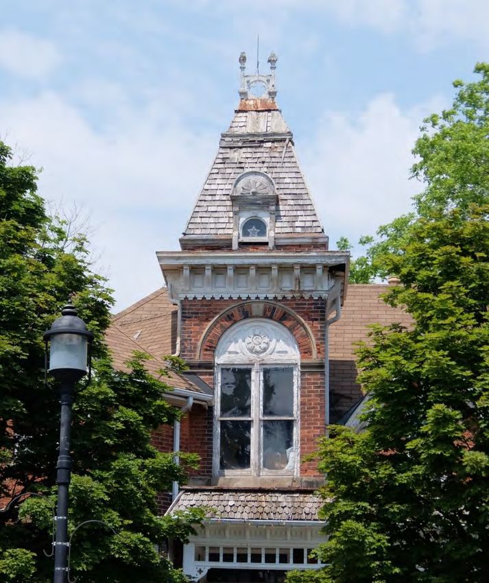
Table of Contents

1. Introduction ............................................................................................................. 7
     1.1 Waterdown Village Built Heritage Inventory Project ........................................... 7
     1.2 Potential Designation and Next Steps ................................................................ 7
     1.3 Property Location ............................................................................................... 7
2. Physiographic Context ........................................................................................... 8
3. Settlement Context ................................................................................................. 9
     3.1 Indigenous Settlement ....................................................................................... 9
     3.2 Euro Canadian Settlement ............................................................................... 10
     3.3 Contemporary Context ..................................................................................... 16
4. Property Description ............................................................................................ 19
     4.1 Evolution of the Buildings and Landscape ....................................................... 19
     4.2 Building Description ......................................................................................... 22
5. Cultural Heritage Evaluation ................................................................................ 24
     5.1 Archaeology ..................................................................................................... 24
           5.1.1 Archaeological Potential ......................................................................... 24
     5.2 Built Heritage.................................................................................................... 25
           5.2.1 Historical Associations ........................................................................... 25
           5.2.2 Architecture and Design ......................................................................... 27
           5.2.3 Integrity .................................................................................................. 27
           5.2.4 Environmental Context ........................................................................... 28
           5.2.5 Social Value ........................................................................................... 29
     5.3 Cultural Heritage Landscapes .......................................................................... 29
6. Cultural Heritage Value: Conclusions and Recommendations ........................ 30
     6.1 Conclusions...................................................................................................... 30
     6.2 Compliance with Ontario Regulation 9/06: Criteria for Determining Cultural
     Heritage Value or Interest ....................................................................................... 30
           6.2.1 Design / Physical Value .......................................................................... 31
           6.2.2 Historical / Associative Value ................................................................. 32
           6.2.3 Contextual Value .................................................................................... 33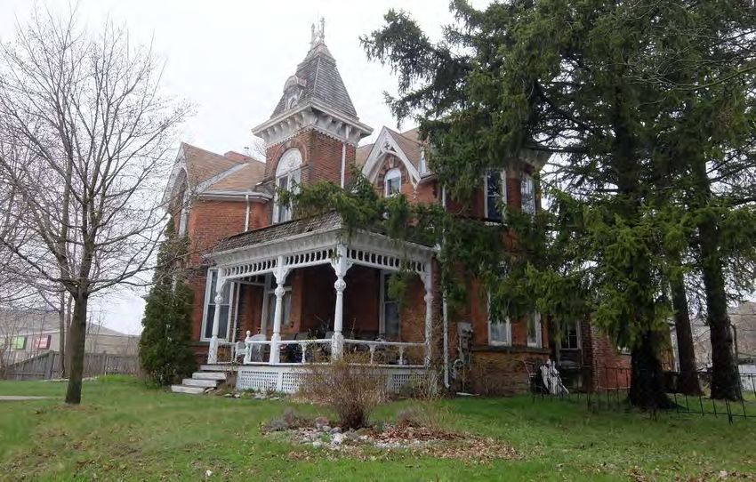
6.3 Recommendation ............................................................................................. 33
Bibliography ................................................................................................................ 36
Appendix A: Location Map ......................................................................................... 39
Appendix B: Photographs .......................................................................................... 40
Appendix C: Historical Images .................................................................................. 43
Appendix D: Plans and Mapping................................................................................ 49
Appendix E: Ownership History................................................................................. 52
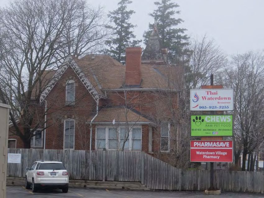
Table of Figures

Figure 1: The physiographic regions of Southern Ontario from Chapman and Putnam's
The Physiography of Southern Ontario, 1984, Page 113 (Approximate location of
Waterdown identified by red circle) ................................................................................. 8
Figure 2: Dish With One Spoon Wampum Belt Reproduction (utoronto.ca) .................... 9
Figure 3: Geneva concessions as illustrated on a map of the treaties with the
Indigenous from the Mississaugas of the Credit First Nation webpage ......................... 11
Figure 4: Lockman A. Cummer; Source: Find A Grave ................................................. 13
Figure 5: Hugh (left) and Fred (right) Carson; Source: Find A Grave ............................ 14
Figure 6: Wentworth County Atlas Map, East Flamborough, Village of Waterdown, 1875
(Excerpt showing the boundaries of John English's property in red) ............................. 15
Figure 7: Twentieth-century commercial buildings west of 289 Dundas Street East,
looking northwest towards Hamilton Street (June 2018) ............................................... 16
Figure 8: North side of Dundas Street looking west from Franklin Street, 289 Dundas
Street at the upper left (June 2018) ............................................................................... 17
Figure 9: Looking east on Dundas Street from Hamilton Street with the building and
mature vegetation at 289 Dundas Street East marking the beginning of the historic core
of Waterdown (June 2018) ............................................................................................ 17
Figure 10: North side of Dundas Street looking east from Hamilton Street, 289 Dundas
Street East on the left (April 2019) ................................................................................ 18
Figure 11: 289 Dundas Street East, highlighted in dark grey, City of Hamilton GISnet,
2019 .............................................................................................................................. 19
Figure 12: Insurance Plan of the Village of Waterdown, ON, May 1939, Excerpt of Sheet
1 (An approximation of the existing property boundary of 289 Dundas Street East
highlighted in red) .......................................................................................................... 19
Figure 13: Carson House and detached coach house, circa 1977, Waterdown; Source:
Flamborough Archives, BW 969 .................................................................................... 20
Figure 14: 289 Dundas Street East, circa late-nineteenth century; Source: Facebook -
Waterdown Memories Group Page, Posted by Jonathon Vance, October 21, 2018 .... 21
Figure 15: 289 Dundas Street East, looking northwest (April 2019) .............................. 21
Figure 16: 289 Dundas Street East, tower details (June 2018) ..................................... 23
Figure 17: Map of subject property and surrounding area, City of Hamilton GISNet ..... 39
Figure 18: Aerial view of subject property and immediate vicinity, City of Hamilton
GISNet (2017) ............................................................................................................... 39
1.         Introduction
This cultural heritage assessment report examines the cultural heritage value or interest
of the property located at 289 Dundas Street East in Waterdown. The property is
comprised of a well-preserved two-storey brick building, originally constructed in the
late-nineteenth century. The subject property was listed on the City’s Municipal Heritage
Register on November 21, 2019 (Planning Committee Report 19-014).

1.1        Waterdown Village Built Heritage Inventory Project
This assessment is conducted as part of the Waterdown Village Built Heritage Inventory
Project, the latest phase in the City of Hamilton’s ongoing Built Heritage Inventory
Process. Previous phases of this process include the Downtown Built Heritage
Inventory Project, completed in 2014 (PED14191), and the Durand Neighbourhood Built
Heritage Inventory, completed in 2017 (PED17092).
The primary goal of this inventory project is to evaluate each property within the
Waterdown Village study area to determine its heritage value or interest. This evaluation
will guide future cultural heritage decision making and policy creation.

1.2        Potential Designation and Next Steps
The subject property has been identified as a property of potentially significant cultural
heritage value. As a result, extensive research has been conducted to determine the
cultural heritage value of the property, which is outlined in this document, and could
result a recommendation for designation under Part IV of the Ontario Heritage Act.

1.3        Property Location
The 0.5-acre subject property, comprised of a two-storey brick dwelling, is located west
of the Village of Waterdown’s historic core on the north side of Dundas Street, close to
the northeast corner of Dundas Street East and Hamilton Street North. (see Appendix
A: Location Map)

CHAR (Draft): Smith-Carson House, 289 Dundas Street East, Waterdown           Page 7 of 52
2.           Physiographic Context
The subject property is located within the physiographic region known as the Niagara
Escarpment, 1 at a point where the escarpment meets the Norfolk Sand Plain and the
Horseshoe Moraine.2 The Niagara Escarpment has greatly influenced land use in
Southern Ontario, its rocky outcroppings limiting agricultural opportunities in certain
areas and concentrating the construction of roads, railways, and urban settlements into
the escarpment’s few breaks and valleys.3 For settlers, the escarpment served as an
important source of building material such as cut stone, lime, and shale, and its
numerous streams and waterfalls permitted the development of early industries such as
Waterdown’s various historic mills. 4

    Figure 1: The physiographic regions of Southern Ontario from Chapman and Putnam's
       The Physiography of Southern Ontario, 1984, Page 113 (Approximate location of
                             Waterdown identified by red circle)

1 L.J. Chapman and D.F. Putnam, The Physiography of Southern Ontario (Toronto: Ontario Ministry of
Natural Resources, 1984), 114-122.
2 L.J Chapman and D.F Putnam, Figure 19: The 55 physiographic regions of Southern Ontario, in The

Physiography of Southern Ontario, by L.J Chapman and D.F Putnam (Toronto: Ontario Ministry of Natural
Resources, 1984), 113.
3 Chapman and Putnam, Physiology of Southern Ontario, 119.
4 Chapman and Putnam, Physiology of Southern Ontario, 119.

CHAR (Draft): Smith-Carson House, 289 Dundas Street East, Waterdown                   Page 8 of 52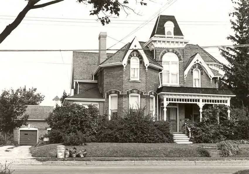
3.          Settlement Context
3.1         Indigenous Settlement
The area encompassing the former Township of East Flamborough and the Village of
Waterdown has attracted human settlement since long before their formal
establishment. The Grindstone Creek runs south through Waterdown towards Hamilton
Harbour and was central to an extensive trail network traveled by the Indigenous
Chonnonton People, commonly known as the Neutrals, which abounded with food and
resources such as sugar maple and salmon.5 These trails, the origins of contemporary
roads such as Snake Road and Old Waterdown Road, led the Neutrals from the base of
the escarpment to their settlements north and west of present day Waterdown.6
The Neutrals, dubbed as such by explorer Samuel Champlain in 1615 for their lack of
participation in wars between the neighbouring Huron and Iroquois people, were a
powerful chiefdom which traded extensively throughout present day Ontario and New
York.7 The Neutral’s population was decimated by a 1638 smallpox outbreak and
subsequent conflict and defeat by the Seneca and Mohawk during the Beaver Wars of
the mid-17th century.8 The Mississaugas, an Anishinaabe nation who inhabited the
lands east of the Neutrals, established settlement in the area following the Beaver Wars
and were the predominant Indigenous group at the time of arrival by European settlers.9
In the late 17th century, the Anishinaabe and Haudenosaunee nations established
peace with the “Dish with One Spoon” Wampum promising that the two nations would
share the bounty of the land (the dish) together (using one spoon).10

        Figure 2: Dish With One Spoon Wampum Belt Reproduction (utoronto.ca)

5 Donald R. Woods and Diane E. Woods, The Mills of Waterdown: The Growth of an Ontario Village –
1790 to 1915 (Waterdown, ON: The Waterdown – East Flamborough Heritage Society, 2010), 2-3; Sylvia
Wray, Robert Wray, Patricia Green and Maurice Green, …and they came to East Flamborough: A
Celebration of East Flamborough Township’s pre-Confederation Heritage (Waterdown, ON: The
Waterdown-East Flamborough Heritage Society, 2015), 18-19.
6 Waterdown-East Flamborough Centennial Committee, 1867-1967: Waterdown and East Flamborough

(Waterdown, ON: Waterdown-East Flamborough Centennial Committee, 1967), 41.
7 Woods and Woods, The Mills of Waterdown, 2-5.
8 Woods and Woods, The Mills of Waterdown, 2-5.; Patricia Green, Maurice Green, Sylvia Wray and

Robert Wray, from West Flamborough’s storied past (Waterdown, ON: The Waterdown – East
Flamborough Heritage Society, 2003), 2.
9 William C. Noble, "The Neutral Confederacy,” Canadian Encyclopedia, last modified October 16, 2018.

https://www.thecanadianencyclopedia.ca/en/article/neutral.; Green, Green, Wray and Wray, from West
Flamborough’s Storied Past, 2.
10 Nathan Tidridge, The Extraordinary History of Flamborough: East Flamborough, West Flamborough &

Waterdown (Waterdown, ON: The Waterdown-East Flamborough Heritage Society, 2016), 11.

CHAR (Draft): Smith-Carson House, 289 Dundas Street East, Waterdown                    Page 9 of 52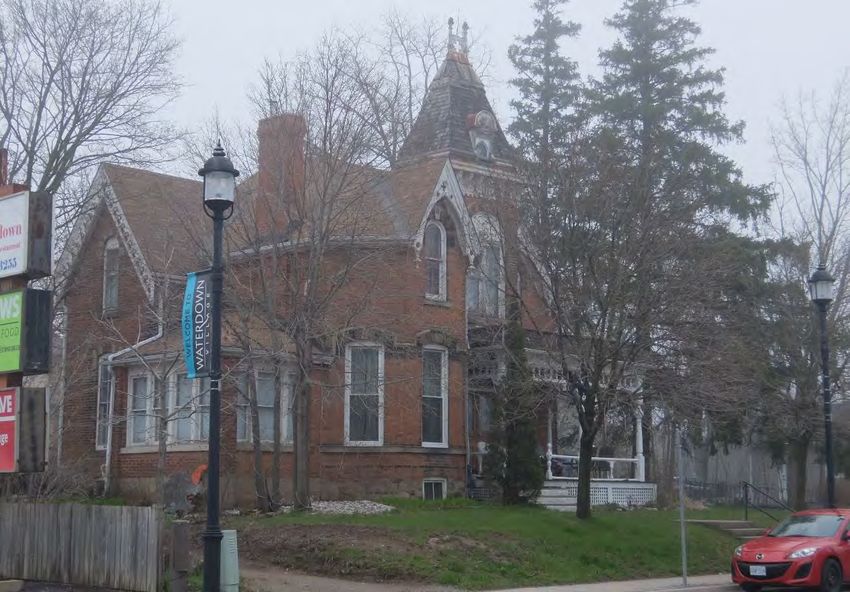
3.2        Euro Canadian Settlement
Beginning in the 1780s, Euro-Canadian settlement in the area superseded that of
Indigenous populations.11 The American War for Independence greatly influenced
settlement in the Flamborough and Waterdown area. Following the establishment of the
United States of America in 1783, approximately 30,000 British Loyalists were displaced
and sought refuge in Britain’s remaining North American colonies.12 In response to this
demand for settlement lands, fifteen land surrender treaties were negotiated between
the Crown and the Anishinaabe peoples living in present day Southern Ontario between
1783 and 1812.13 These treaties gave the colonial government authority to survey and
eventually distribute lands to Loyalists and other European settlers.14 In 1788, to further
facilitate the surveying of new settlement lands, the western extent of Quebec’s District
of Montreal was subdivided into four districts: Lunenburg, Mecklenburg, Nassau and
Hesse. The area which would become East Flamborough, and subsequently the Village
of Waterdown, was situated within the District of Nassau.15
In 1791, a portion of Quebec, including the new districts, was separated to establish the
Province of Upper Canada. Newly appointed Lieutenant Governor John Graves Simcoe
named Augustus Jones Provincial Land Surveyor and directed him to travel west from
the Niagara River to survey and lay out Townships.16 In 1792 Treaty No. 3, the Between
the Lakes Purchase, was negotiated between the Crown and the Mississaugas, giving
Upper Canada ownership and access to a vast swath of land between Lake Erie and
Lake Ontario.17 The final component of Jones’ initial survey was the Township of
Geneva, four concessions along the broken front of Lake Geneva, now known as
Burlington Bay. Geneva’s concessions were surveyed from the “Indian Point”, a line
which divided the lands to the west purchased by the crown, and the lands to the east
still claimed by the Mississaugas. Initially set out for refugees of the French Revolution,
an additional 10 concessions were surveyed to the north of Geneva and amalgamated
with the Township and the lands surrounding the town of Dundas to form the Township
of Flamborough in 1793.18

11 Noble, “The Neutral Confederacy.”
12 “Upper Canada Land Surrenders and the Williams Treaties (1764-1862/1923),” Government of
Canada, last modified February 15, 2013, https://www.rcaanc-
cirnac.gc.ca/eng/1360941656761/1544619778887#uc.
13 “Upper Canada Land Surrenders,” Government of Canada.
14 “Upper Canada Land Surrenders,” Government of Canada.
15 Wray, Wray, Green and Green, …and they came to East Flamborough, 1-3.
16 Wray, Wray, Green and Green, …and they came to East Flamborough, 1-3.
17 “Upper Canada Land Surrenders,” Government of Canada.; Donna Duric, “Between the Lakes Treaty

No. 3 (1792),” Mississaugas of the Credit First Nation, last modified May 18, 2017,
http://mncfn.ca/treaty3/.
18 Wray, Wray, Green and Green, …and they came to East Flamborough, 1-2.

CHAR (Draft): Smith-Carson House, 289 Dundas Street East, Waterdown               Page 10 of 52
Figure 3: Geneva concessions as illustrated on a map of the treaties with the
          Indigenous from the Mississaugas of the Credit First Nation webpage

Construction began in 1793 on a highway commissioned by Lt. Governor John Simcoe,
which initially ran westward from Burlington Bay to Joseph Brant’s village on the Grand
River.19 Subsequently, the previously established Land Board began accepting
applications for property grants in Flamborough, awarding land mostly to members of
the military and government officials who typically remained absentee landlords.20 In
1796, Lieutenant Alexander McDonnell was awarded approximately 3000 acres
including Lots 6 and 7 of Concession 3, the location of the original village core of
Waterdown.21 Following boundary realignments and territorial renaming within Upper
Canada between 1793 and 1798, the Township of Flamborough was split into the
Townships of East and West Flamborough in 1798. 22
McDonnell’s land went undeveloped and 800 acres were acquired by Alexander Brown
in 1805, who then established the area’s first sawmill above the Great Falls at Smokey
Hollow and the Grindstone Creek.23 That same year, Treaty No. 14, the Head of the
Lake Treaty, was negotiated and the Crown acquired Mississauga lands east of East
Flamborough, allowing for the easterly expansion of Lt. Governor Simcoe’s highway,

19 Sylvia Wray, Dundas Street, Waterdown, 1793-1993 (Waterdown, ON: The Waterdown-East
Flamborough Heritage Society, 1994), 3.
20 Wray, Wray, Green and Green, …and they came to East Flamborough, 2-3.
21 Wray, Wray, Green and Green, …and they came to East Flamborough, 2-3.; Unterman McPhail

Cuming Associates and Wendy Shearer Landscape Architect Limited, Waterdown Heritage Conservation
District Study: Heritage Assessment Report (1996), 2-1.; Woods and Woods, The Mills of Waterdown, 20.
22 Wray, From West Flamborough’s Storied Past, 4.
23 Wray, Wray, Green and Green, …and they came to East Flamborough, 18.; Woods and Woods, The

Mills of Waterdown, 21.

CHAR (Draft): Smith-Carson House, 289 Dundas Street East, Waterdown                  Page 11 of 52
which would become Provincial Highway 5 and Dundas Street in Waterdown.24 While previously difficult to access and largely untouched, the road and potential for water power made settlement in East Flamborough appealing to many, and slowly settlement and associated industry increased throughout the early 19 th century.25 Lieutenant Governor Simcoe’s highway was a response to concerns about surprise attacks from the newly liberated American colonies and was intended to serve as a military passage for the movement of troops and supplies. Its secondary purpose was a means of encouraging settlement; however, construction did not begin until Simcoe’s decision to move the capital to present day London. The first section of it, which became known as The Governor’s Road, stretched from Burlington Bay to the Grand River. The second section was intended to extend the road to London, but Simcoe changed the location of the capital to York (modern day Toronto) causing construction to cease and nature to retake their hard work. Land grants were offered along this strip of highway with the stipulation that owners were required to keep the roadway clear. Work on the trail from Dundas began immediately following the movement of the capital but the second section of it, which stretched from Burlington Bay to York, was not started until a decade later due to the success of water transportation along Lake Ontario. This road from Dundas to York was named the Dundas Highway in honour of Henry Dundas, the Home Secretary responsible for Colonial Affairs. This roadway began as an Indigenous trail before being turned into a highway serving an important role in the history of both Waterdown and Ontario.26 In 1823, Ebenezer C. Griffin arrived in the area, having previously purchased the majority of Concession 3, Lot 7 from Alexander Brown.27 He established a number of businesses, including a store at the corner of Mill and Dundas Street, a flour mill above the Great Falls, and a carding mill on Mill Street South.28 The area came to be known as Waterdown, and in 1831 Griffin prepared a village plan which became known as the Griffin Survey and began to sell off lots.29 In 1836, E.C Griffin sold his mill operations at what would become known as Smokey Hollow to George Abrey and John Heywood and in 1837 received a grant to Concession 3, Lot 6.30 Cummer Family in Waterdown The Cummer family were United Empire Loyalists that came to the Waterdown area in the late 1700s. Lockman A. Cummer (1827-1907, Figure 4) made significant contributions to the village’s industrial development operating every type of mill at most of the mill sites, operating a sawmill and flour mill at Smokey Hollow, and building row houses for mill workers (40-42 Mill Street South). He came to Waterdown in 1846 to 24 Wray, Dundas Street, 4; Wray, Wray, Green and Green, …and they came to East Flamborough, 3.; Donna Duric, “Head of the Lake, Treaty No. 14 (1806),” Mississaugas of the Credit First Nation, last modified May 28, 2017, http://mncfn.ca/head-of-the-lake-purchase-treaty-14/. 25 Wray, Wray, Green and Green, …and they came to East Flamborough, 18. 26 Wray, Dundas Street, 3-5. 27 Woods and Woods, The Mills of Waterdown, 44. 28 Woods and Woods, The Mills of Waterdown, 44-46. 29 Woods and Woods, The Mills of Waterdown, 50-54.; Wray, Wray, Green and Green, …and they came to East Flamborough, 18. 30 Woods and Woods, The Mills of Waterdown, 52. CHAR (Draft): Smith-Carson House, 289 Dundas Street East, Waterdown Page 12 of 52
supervise the building of his father’s house (265 Mill Street South) moving in with his
parents after its completion. He married Rachel Catherine Lottridge (1831-1864) on July
18, 1849. After her death in 1864, he remarried Flora Ann Creen. Lockman operated
various businesses with the Lottridge family including the Ceres Flour Mill at the
McNairn Corner Mill site. He also operated a sawmill and flour mill with John Creen and
formed a partnership with Jacob Cummer and William Gill in 1855 to establish Cummer,
Gill & Co., manufacturers of their patented and improved steam engine as well as mill
stones and boilers. Lockman Cummer also served on the Village Council.

                      Figure 4: Lockman A. Cummer; Source: Find A Grave

Smith Family in Waterdown
Richard “Dick” Smith (died 1960) was a Reeve of Waterdown from 1920-1924 and
1932-1943 and ran the largest market garden in the area behind Cedar Street that was
irrigated by a water tank filled with water pumped from the swamp that was located
behind Cedar and John Streets.31 The fire of 1922 occurred during his first term leading
to his establishment of the rule that only fire-proof buildings were to be constructed in
the downtown core resulting in the current character of that area. Richard Smith was
one of few Reeves elected by acclamation and was successful in securing a World War
I trophy of a barrel assembly for a 1916 German Howitzer that resides in Sealey Park.

31
     Centennial Committee, 1867-1967, 87.

CHAR (Draft): Smith-Carson House, 289 Dundas Street East, Waterdown        Page 13 of 52
Carson Family in Waterdown
The Carson family has a long history in Waterdown starting with the establishment of
Hugh Carson & Sons, a quarry and construction business, in 1865. Hugh Carson (1840-
1921, Figure 5) quarried both sandstone and limestone with the product being used to
build mills, bridges, canal walls and peers in Toronto, Hamilton, Burlington and beyond.
Notable structures that used his product include some of the University of Toronto
buildings, the Ontario Parliament Buildings and the original swing bridge over the
Burlington Canal.
Hugh’s son, Frederick Carson (1873-1953, Figure 5), took over the business upon his
death in 1921 renaming it Fred Carson & Sons and focusing on construction. Fred
Carson & Sons owned one of the first steam shovels in the area, installed the first
waterworks in Waterdown including watermains, pumping stations, a standby reservoir
and a water tower, and aided the Department of Defence in paving airport runways
during the Second World War including Mount Hope (Hamilton), Centrilla (London),
Trenton (Trenton), Camp Borden (Barrie), Rockcliffe (Ottawa) and North Bay (North
Bay). Fred Carson & Sons built their own specialized equipment, repaired it themselves
and modified new equipment to suit their needs. The Government even reported them
as having “the most versatile and fastest equipment for road surface treatment in
Ontario.”32 They were so dedicated to the Waterdown area that they tried to buy locally
as much as they could. Fred’s son, Cecil Carson, also worked in the family business
until it closed in 1987.
Figure 5: Hugh (left) and Fred (right) Carson; Source: Find A Grave
32
Don Wood, Levern Carson Interview, Flamborough Archives, 5.
CHAR (Draft): Smith-Carson House, 289 Dundas Street East, Waterdown Page 14 of 52Subject Property – Block 20 (see Appendix E: Ownership History)
The subject property is part of Lot 7 Concession 3, which was granted by the Crown to
Alexander MacDonnell in 1796. In 1805, Alexander Brown purchased MacDonnell’s two
hundred acres then subsequently sold one hundred and fifty-five of those acres to E.C.
Griffin in 1821.33 From 1821 to 1871, the property history is unclear. In 1867, John
English filed a lawsuit against various village landowners, including his own family
members, for the rights to eleven and a half acres of land.34 It is believed that the eleven
and a half acres of land is comprised of small sections of land from each of the
landowners included in the lawsuit; however, the amounts from each landowner and
their locations are unknown. In 1871, the lawsuit ends, and John English is granted his
eleven and a half acres.35 Historic mapping indicates that in 1875 John English owned a
plot of land on the western edge of the village (Figure 6) but in 1854 that same area of
land is part of a much larger plot.
Figure 6: Wentworth County Atlas Map, East Flamborough, Village of Waterdown, 1875
(Excerpt showing the boundaries of John English's property in red)
33
“Hamilton Wentworth (62), Waterdown, Book 1 Waterdown; Parts of Lot 6 and 7; Concession 3 East
Flamborough; Prior Title to E.C. Griffins Survey; Village Lot in Waterdown,” Ontario Land Registry
Access, 4-5, https://www.onland.ca/ui/62/books/21129/viewer/279447577?page=4.
34
“Hamilton Wentworth (62), Waterdown, Book 1,” Ontario Land Registry Access, 70-71.
35
“Hamilton Wentworth (62), Waterdown, Book 1,” Ontario Land Registry Access, 118-119.
CHAR (Draft): Smith-Carson House, 289 Dundas Street East, Waterdown Page 15 of 52In 1883, John English sold three and three-tenths of an acre to Flora A. Cummer36 who
then sold it to Jane Davidson six years later.37 The Davidson family owned the property
until 1898 when it was sold to Richard Smith.38 Smith owned the property until his death
and subsequent granting of the property to Cecil Carson in 1959.39 The property is still
owned by a member of the Carson family.
According to the tax assessment records, the property was valued at $700 in 1882
when John English owned it with an increase in value to $3,700 in 1885 during the
Cummer family’s ownership of the property. There is a gap in the tax assessment
records between 1882 and 1885 making it difficult to ascertain a precise construction
date; however, considering that Flora Cummer purchased the property in 1883, it is
believed that the Cummer family built the house between 1883 and 1885.
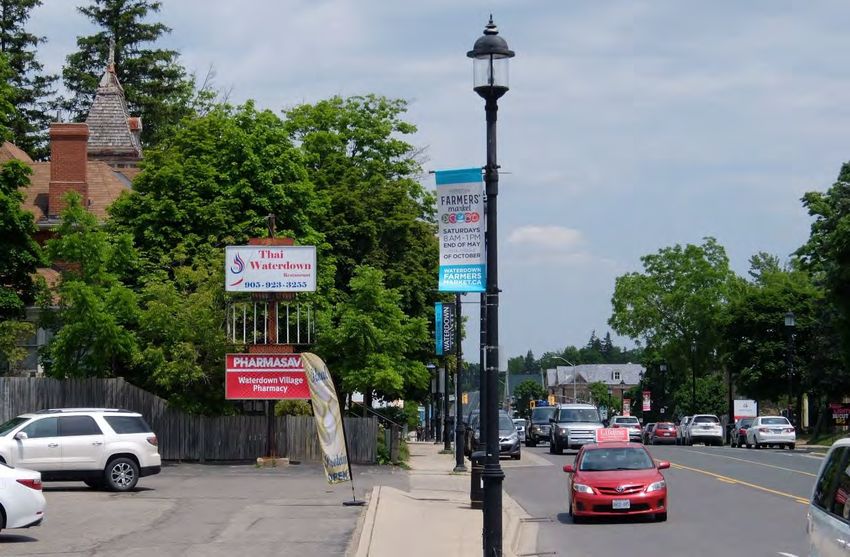
3.3 Contemporary Context
The subject property is located near the northeast corner of Dundas Street East and
Hamilton Street North. The immediate area on the north and south side of Dundas
Street East features variably-sized commercial buildings, many of which are converted
from former dwellings, that possess various setbacks, heights and styles. The east and
west sides of Hamilton Street North are comprised of commercial structures of varying
setbacks, heights and styles whereas the east and west sides of Hamilton Street South
contain residential structures of the same varying details. The streetscape is
characterized mostly by commercial driveways and businesses set close to the road
with some tree cover and front-facing landscaping.
Figure 7: Twentieth-century commercial buildings west of 289 Dundas Street East,
looking northwest towards Hamilton Street (June 2018)
36
“Hamilton Wentworth (62), Waterdown, Book 1,” Ontario Land Registry Access, 132-133.
37
“Hamilton Wentworth (62), Waterdown, Book 1,” Ontario Land Registry Access, 152-153.
38
“Hamilton Wentworth (62), Waterdown, Book 3; Part 1; Plan 355 and 741,” Ontario Land Registry
Access, 288-289, https://www.onland.ca/ui/62/books/21115/viewer/681779729?page=1.
39
“Hamilton Wentworth (62), Waterdown, Book 4; Part 2; Plan 355 and 741,” Ontario Land Registry
Access, 482-483, https://www.onland.ca/ui/62/books/21120/viewer/679682579?page=1.
CHAR (Draft): Smith-Carson House, 289 Dundas Street East, Waterdown Page 16 of 52Figure 8: North side of Dundas Street looking west from Franklin Street, 289 Dundas
Street at the upper left (June 2018)
Figure 9: Looking east on Dundas Street from Hamilton Street with the building and
mature vegetation at 289 Dundas Street East marking the beginning of the historic core
of Waterdown (June 2018)
CHAR (Draft): Smith-Carson House, 289 Dundas Street East, Waterdown Page 17 of 52Figure 10: North side of Dundas Street looking east from Hamilton Street, 289 Dundas
Street East on the left (April 2019)
CHAR (Draft): Smith-Carson House, 289 Dundas Street East, Waterdown Page 18 of 524. Property Description
The 0.5-acre property at 289 Dundas Street East is comprised of a two-storey single-
detached brick building, situated on the north side of Dundas Street East near the
northeast corner of Dundas Street and Hamilton Street in the former Village of
Waterdown and the former Township of East Flamborough, within the City of Hamilton.
Figure 11: 289 Dundas Street East, highlighted in dark grey, City of Hamilton GISnet,
2019
4.1 Evolution of the Buildings and Landscape
The two-storey brick building has undergone few alterations since it was first
constructed between 1882 and 1885. The 1939 Fire Insurance Plan of the Village
(Figure 12) indicates that the then 3.3-acre property consisted of a principal two-storey
dwelling fronting onto Dundas Street, and a detached coach house with addition to the
north-west of the dwelling (Figure 13).
Figure 12: Insurance Plan of the Village of Waterdown, ON, May 1939, Excerpt of Sheet
1 (An approximation of the existing property boundary of 289 Dundas Street East
highlighted in red)
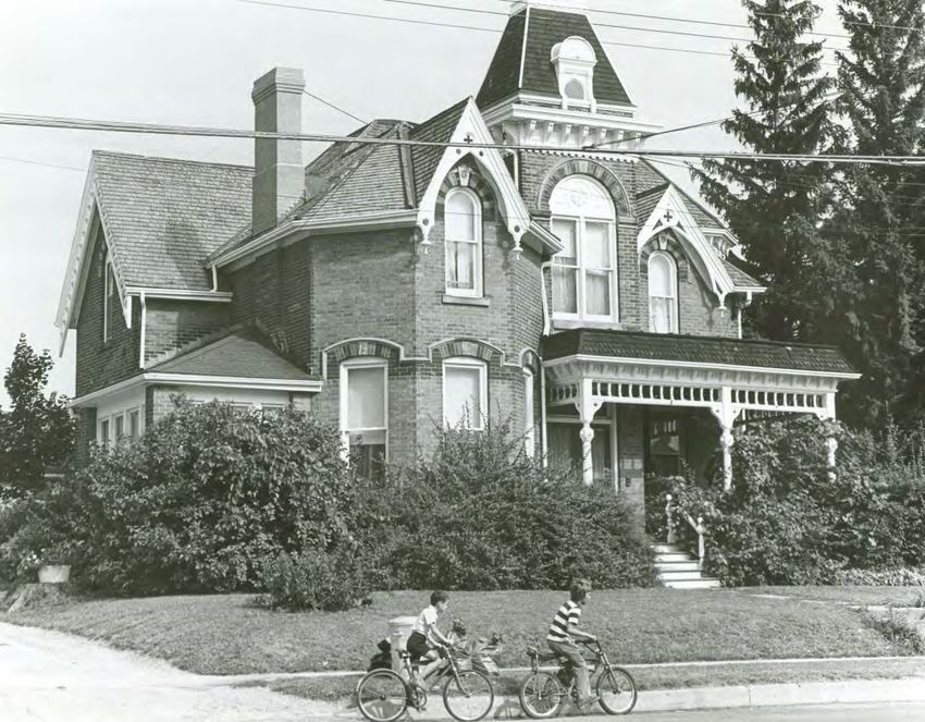
CHAR (Draft): Smith-Carson House, 289 Dundas Street East, Waterdown Page 19 of 52Figure 13: Carson House and detached coach house, circa 1977, Waterdown; Source:
Flamborough Archives, BW 969
The most notable alterations that have taken place to the principal building, and its
surroundings, include:
• Planting of trees in the front yard (circa construction of the house);
• Extension of the front porch to cover the main entrance, including removal of the
iron cresting and recreating the existing porch details, such as the decorative
posts, brackets and spindles (circa early- twentieth century);
• Removal of the wood shutters (circa mid-twentieth century);
• Removal of the rear one-storey coach house (between 1977 and 1995);
• Modification of the double front doors converting the two moulded upper panels
in each door into one window panel (circa twentieth century);
• Construction of a one-storey hipped roof side addition on the southwest corner
(pre-1977);
• Replacement of the original cedar shingle roof with an asphalt roof (between
1977 and 1984) excluding the tower; and,
• Removal of the decorative front yard fencing.
CHAR (Draft): Smith-Carson House, 289 Dundas Street East, Waterdown Page 20 of 52Figure 14: 289 Dundas Street East, circa late-nineteenth century; Source: Facebook -
Waterdown Memories Group Page, Posted by Jonathon Vance, October 21, 2018
Figure 15: 289 Dundas Street East, looking northwest (April 2019)
CHAR (Draft): Smith-Carson House, 289 Dundas Street East, Waterdown Page 21 of 524.2 Building Description
The property is comprised of a two-storey, single-detached brick building believed to
have been constructed between 1882 and 1885. The features of the building
demonstrate influences from the Queen Anne architectural style, including the:
• Rectangular footprint with a truncated hip roof punctuated by projecting bays on
the front (east) and side facades, a front tower and side chimney;
• Two-and-a-half-storey front tower with a:
o High hip roof clad in cedar shingles with a boxed cornice with decorative
brackets, panels and trim, a decorated hooded dormer and an ornate
finial;
o Semi-circular second-storey window with a decorated wood transom and
paired flat-headed hung wood windows below; and,
o A ground floor front entrance with a wood double door with moulded
panels and a transom;
• Projecting high-pitched gables on the east, south and west facades with boxed
cornices and decorative bargeboard;
• Projecting two-storey side (north) bay with a hip roof, projecting eaves, boxed
cornice and decorative brackets;
• Single brick corbelled chimney offset to the west side;
• Red brick facade laid in Stretcher bond;
• Broken-course stone foundation with segmentally-shaped basement window
openings with brick voussoirs;
• Semi-circular and segmental window openings featuring polychromatic
brickwork, decorated keystones, stone detailing and stone lug and continuous
sills;
• Covered front porch with a wood-shingle clad mansard roof, decorative brackets,
treillage, shaped posts and open railing;
• One-storey, hipped-roof addition on the front southwest corner with grouped flat-
headed hung windows with continuous sills;
• One-storey shed-roof addition on the rear northeast corner projecting out from
behind the side bay with raised entry door.
CHAR (Draft): Smith-Carson House, 289 Dundas Street East, Waterdown Page 22 of 52Figure 16: 289 Dundas Street East, tower details (June 2018) CHAR (Draft): Smith-Carson House, 289 Dundas Street East, Waterdown Page 23 of 52
5.         Cultural Heritage Evaluation
The following is an evaluation of the cultural heritage value or interest of the subject
property, in accordance with Ontario Regulation 9/06 and the City of Hamilton’s
Framework for Cultural Heritage Evaluation.
The subject property has been evaluated against three sets of criteria – Archaeology,
Built Heritage, and Cultural Heritage Landscapes – as follows:

5.1        Archaeology
Identified or potential archaeological resources can be considered as values meriting
inclusion into the identified cultural heritage value for the designation of a property. A
set of twelve criteria is used to evaluate an archaeological site or measure
archaeological potential to determine what attributes, if any, warrant designation under
Part IV of the Ontario Heritage Act.
The first eleven criteria for designation of an archaeological site are predicated on the
presence of an archaeological site. In the case of 289 Dundas Street East, there are no
registered or reported archaeological sites located on the subject property. As a result,
only the Archaeological Potential criterion applies in this assessment.
 Archaeological Criteria
 Cultural Definition: N/A                      Site Setting: N/A
 Temporal Integrity: N/A                       Site Socio-political Value: N/A
 Site Size: N/A                                Site Uniqueness: N/A
 Site Type: N/A                                Site Rarity: N/A
 Site Integrity: N/A                           Site Human Remains: N/A
 Historical Association: N/A                   Archaeological Site Potential: Applicable

5.1.1      Archaeological Potential
The subject property is comprised of a two-storey building, situated in an urban context
first developed in the late-nineteenth century. To be considered a site with archeological
potential the property must meet at least one of the primary criteria or two of the
secondary criteria for determining archaeological potential. The subject property is
within 250 metres of a known archaeological site (AiGx-373), meeting one primary
criteria. The property is also within 100 meters of an historic transportation corridor
(Dundas Street) and is in a historic urban boundary of Euro-Canadian activity
(Waterdown Village), meeting two secondary criteria. In addition, the property has
experienced minimal disturbance. The property meets one primary criteria and two
secondary criteria for determining archaeological potential and, therefore, this criterion
is considered satisfied.

CHAR (Draft): Smith-Carson House, 289 Dundas Street East, Waterdown           Page 24 of 52
5.2        Built Heritage
A set of twelve criteria is used to identify and assess the built heritage value of a
property. Of the twelve criteria, nine were applicable and satisfied for 289 Dundas Street
East.
 Historical Associations                       Architecture and Design
 Thematic: Applicable                          Architectural Merit: Applicable
 Event: N/A                                    Functional Merit: N/A
 Person and/or Group: Applicable               Designer: Unknown
 Integrity                                     Environmental Context
 Location Integrity: Applicable                Landmark: Applicable
                                               Character: Applicable
 Built Integrity: Applicable
                                               Setting: Applicable
 Social Value
 Public Perception: Applicable

5.2.1      Historical Associations

Thematic
The property has direct associations with the themes of village development,
commercial growth and historic preservation, as indicated in the history of the property
in relation to the history of the village.
As depicted in the 1854 village survey, this property was located at the southwest edge
of the village. In 1883, Flora Cummer purchased the yet-to-be-developed land and
constructed a house circa 1885. As the village developed, the southwest limits of the
village moved farther from this property, changing its context from a mixed residential
and farming area to a residential area, and, finally, to a mixed commercial and
residential area. Despite the changing context surrounding this property, it has been
subject to few alterations maintaining its historic character and indicating a focus on
heritage preservation that is still quite prevalent within in the village today. Therefore,
this criterion is considered satisfied.

Event
A specific event that has made a significant contribution to Waterdown, Ontario or
Canada is not known to have occurred here.

Person/Group
The property has a direct association with three prominent families in Waterdown: the
Cummer family, the Smith family and the Carson family. The Cummer family were
United Empire Loyalists that came to the Waterdown area in the late 1700s. Lockman
A. Cummer (1827-1907) made significant contributions to the village’s industrial
development operating every type of mill at most of the mill sites, operating a sawmill

CHAR (Draft): Smith-Carson House, 289 Dundas Street East, Waterdown          Page 25 of 52
and flour mill at Smokey Hollow, and building row houses for mill workers (40-42 Mill
Street South). He came to Waterdown in 1846 to supervise the building of his father’s
house (265 Mill Street South) moving in with his parents after its completion. He married
Rachel Catherine Lottridge (1831-1864) on July 18, 1849. After her death in 1864, he
remarried Flora Ann Creen. Lockman operated various businesses with the Lottridge
family including the Ceres Flour Mill at the McNairn Corner Mill site. He also operated a
sawmill and flour mill with John Creen and formed a partnership with Jacob Cummer
and William Gill in 1855 to establish Cummer, Gill & Co., manufacturers of their
patented and improved steam engine as well as mill stones and boilers. Lockman
Cummer also served on the Village Council.
The property also has direct association with the Smith family. Richard “Dick” Smith
(died 1960) was a Reeve of Waterdown from 1920-1924 and 1932-1943 and ran the
largest market garden in the area behind Cedar Street that was irrigated by a water tank
filled with water pumped from the swamp that was located behind Cedar and John
Streets.40 The fire of 1922 occurred during his first term leading to his establishment of
the rule that only fire-proof buildings were to be constructed in the downtown core
resulting in the current character of that area. Richard Smith was one of few Reeves
elected by acclamation and was successful in securing a World War I trophy of a barrel
assembly for a 1916 German Howitzer that resides in Sealey Park.
In addition, the property also has direct association with the Carson family, who were
granted the property in 1959 and have owned it ever since. The Carson family has a
long history in Waterdown starting with the establishment of Hugh Carson & Sons, a
quarry an construction business, in 1865. Hugh Carson (1840-1921) quarried both
sandstone and limestone with the product being used to build mills, bridges, canal walls
and peers in Toronto, Hamilton, Burlington and beyond. Notable structures that used his
product include some of the University of Toronto buildings, the Ontario Parliament
Buildings and the original swing bridge over the Burlington Canal. His son, Frederick
Carson (1873-1953), took over the business upon his death in 1921 renaming it Fred
Carson & Sons and focusing on construction. Fred Carson & Sons owned one of the
first steam shovels in the area, installed the first waterworks in Waterdown including
watermains, pumping stations, a standby reservoir and a water tower, and aided the
Department of Defence in paving airport runways during the Second World War
including Mount Hope (Hamilton), Centrilla (London), Trenton (Trenton), Camp Borden
(Barrie), Rockcliffe (Ottawa) and North Bay (North Bay). Fred Carson & Sons built their
own specialized equipment, repaired it themselves and modified new equipment to suit
their needs. The Government even reported them as having “the most versatile and
fastest equipment for road surface treatment in Ontario.”41 They were so dedicated to
the Waterdown area that they tried to buy locally as much as they could. Fred’s son,
Cecil Carson, also worked in the family business until it closed in 1987.
40
Centennial Committee, 1867-1967, 87.
41
Don Wood, Levern Carson Interview, Flamborough Archives, 5.
CHAR (Draft): Smith-Carson House, 289 Dundas Street East, Waterdown Page 26 of 525.2.2 Architecture and Design Architectural Merit The property is comprised of a two-storey brick dwelling influenced by the Queen Anne architectural style. It was constructed circa 1885 as a residence and has remained a dwelling throughout its history. The architectural merit of the building lies in its architectural features typical of, and influenced by, the Queen Anne architectural style, including the: red brick construction; hip roof punctuated by multiple gables, a chimney and a front tower; decorative bargeboard; ornately-decorated, covered front porch; and, the use of a variety of materials and textures, including brick, wood and stone. The property exhibits a high degree of craftsmanship and artistic merit through the wood detailing including the decorative bargeboard and treillage on the front porch, the stone detailing on the voussoirs and keystones, and the polychromatic brickwork. Therefore, this criterion is considered satisfied. Functional Merit The subject property was constructed as a residence circa 1885. It is a typical example of a Queen Anne style structure, uses typical construction methods and does not possess any utilitarian features. Therefore, this criterion is not considered satisfied. Designer The designer of the building is unknown based on the research conducted. Therefore, this criterion is not satisfied at this time, but may be satisfied subject to further research and information. 5.2.3 Integrity Location Integrity The building at 289 Dundas Street East remains in its original location. This fact is important since a historic building in its original location has greater cultural heritage value than one that has been moved from its original site. Therefore, this criterion is considered satisfied. Built Integrity Despite some alterations, many of the original features of the building remain unchanged and the exterior facades remain largely untouched. The front porch, with its shaped posts, treillage and mansard roof, was expanded in the early-twentieth century not long after the home’s construction; however, the extension was completed in a sympathetic manner and the porch has become an integral part of the historic structure. CHAR (Draft): Smith-Carson House, 289 Dundas Street East, Waterdown Page 27 of 52
The interior of the building is presumed to be altered over time; however, there is
potential that some of its original interior elements may remain intact considering the
limited exterior alterations and the continued ownership by the Carson family. This
warrants further investigation, if given the opportunity. Therefore, this criterion is
considered satisfied.

5.2.4       Environmental Context

Landmark
The property is considered a local landmark. It is a prominent feature on the streetscape
of Dundas Street recognizable by residents of the village at a glance as one of few
buildings featuring the Queen Anne architectural style. In addition, the front tower
projects above the mature trees surrounding the house, serving as a visible marker as
you enter the village from the west and marking the transition between the modern
commercial area to the west and the historic commercial area to the east. Therefore,
this criterion is considered satisfied.

Character
The north side of Dundas Street East, west of Main Street North, has evolved from
mostly farm land with some residential and commercial properties in the mid-nineteenth
century, to a mixed streetscape consisting of residential and commercial buildings in the
late-nineteenth century with later additions of some institutional buildings in the
twentieth century, to the current mixed commercial and residential streetscape.
The property is important in defining the historic character of the area. The late-
nineteenth century single-detached building defines the early residential character on
the west end of Dundas Street and is visually and historically linked to its surroundings.
The streetscape is characterized by a mixture of traditional building materials (brick,
stone, wood) and modern building materials (concrete, vinyl), heights ranging from one
to two storeys, and eclectic architectural styles that demonstrate the development of the
Village of Waterdown. Therefore, this criterion is considered satisfied.

Setting
The property contributes to the character of Dundas Street East, which features
buildings of various ages and architectural influences. This section of Dundas Street
East includes one- to two-storey buildings dating between the mid-nineteenth century to
modern day. This property marks the transition from the modern shopping plazas and
commercial structures to the west to the historic downtown core of Waterdown further
east. In addition, the house is surrounded by mature trees that often hide the house,
except for the tower, from view. Due to the widening of the street, the historic front
fencing has been removed from the front yard. Therefore, this criterion is considered
satisfied.

CHAR (Draft): Smith-Carson House, 289 Dundas Street East, Waterdown         Page 28 of 52
5.2.5      Social Value

Public Perception
Through its inclusion in various Waterdown specific histories and studies, the subject
property has continued to demonstrate its value to the village.
The subject property, identified as the Smith-Carson House, was included in Sylvia
Wray and Maurice Green’s Dundas Street Waterdown 1793-1993, which documents the
history of the main thoroughfare in the village. The history of the building and its
occupants is outlined, and historic photographs included to showcase it as one of few
significant residences that existed on Dundas Street during the indicated period.
The subject property was included in a historic walking tour hosted by the Flamborough
Archives, has been previously evaluated by the former Local Architectural Conservation
Advisory Committee of Waterdown and was evaluated by the Canadian Ministry of
Transportation and Communications in 1983 as part of a report to determine the impact
of the widening of Dundas Street between Evans and Syndenham Roads. Therefore,
this criterion is considered satisfied.

5.3        Cultural Heritage Landscapes
A set of nine criteria is used to identify and assess the potential for a cultural heritage
landscape. In the case of 298 Dundas Street East, the subject property does contain
mature trees, used to have a coach house that is no longer extant, and is a part of two
identified landscapes, Dundas Street and the Village of Waterdown, but on its own is
not considered to be a cultural heritage landscape. As a result, none of the Cultural
Heritage Landscape criteria apply.
 Historical Associations                       Scenic Amenity
 Thematic: N/A                                 Sense of Place: N/A
 Event: N/A                                    Serial Vision: N/A
 Person and/or Group: N/A                      Material Content: N/A
 Integrity                                     Design
 Integrity: N/A                                Design: N/A
 Social Value
 Public Perception: N/A

CHAR (Draft): Smith-Carson House, 289 Dundas Street East, Waterdown           Page 29 of 52
6.         Cultural Heritage Value: Conclusions
           and Recommendations
6.1        Conclusions
The subject property possesses high archeological potential but does not satisfy any of
the other eleven criteria indicated under the City’s guidelines for archeology. In addition,
the property is not considered to be a cultural heritage landscape. Therefore, the
subject property is not considered to have heritage value worthy of designation
according to those two categories. However, the subject property does satisfy nine of
the twelve criteria pertaining to built heritage, including:
   •   Historical Associations:
          o Thematic
          o Person and/or Group
   •   Architecture and Design:
          o Architectural Merit
   •   Integrity:
          o Location Integrity
          o Built Integrity
   •   Environmental Context:
          o Landmark
          o Character
          o Setting
   •   Social Value:
          o Public Perception

6.2        Compliance with Ontario Regulation 9/06: Criteria for
           Determining Cultural Heritage Value or Interest
According to Subsection 1 (2) of Ontario Regulation 9/06, Criteria for Determining
Cultural Heritage Value or Interest, a property may be designated under section 29 of
the Ontario Heritage Act if it meets one or more of the following criteria:

CHAR (Draft): Smith-Carson House, 289 Dundas Street East, Waterdown          Page 30 of 52
1) The property has design value or physical value because it,
i) is a rare, unique, representative or early example of a style, type, expression,
material or construction method,
ii) displays a high degree of craftsmanship or artistic merit, or
iii) demonstrates a high degree of technical or scientific achievement.
2) The property has historical value or associative value because it,
i) has direct associations with a theme, event, belief, person, activity,
organization or institution that is significant to a community,
ii) yields, or has the potential to yield, information that contributes to an
understanding of a community or culture, or
iii) demonstrates or reflects the work or ideas of an architect, artist, builder,
designer or theorist who is significant to a community.
3) The property has contextual value because it,
i) is important in defining, maintaining or supporting the character of an area,
ii) is physically, functionally, visually or historically linked to its surroundings, or
iii) is a landmark.
The subject property has design value because it is a representative example of an
architectural style and displays a high degree of craftsmanship and artistic merit; it has
historical value because it has direct associations with people significant to the
community; and, it has contextual value because it is important in defining the character
of the area, it is physically, functionally, visually and historically linked to its
surroundings, and is considered to be a local landmark. The following is a summary of
the cultural heritage value of the subject property according to Ontario Regulation 9/06:
6.2.1 Design / Physical Value
The property comprises a two-storey brick building influenced by the Queen Anne
architectural style. It was constructed circa 1885 as a residence and has remained a
dwelling ever since. The design value of the building lies in its architectural features,
typical of, and influenced by, the Queen Anne architectural style, including the: red brick
construction; hip roof punctuated by multiple gables, a chimney and a front tower;
decorative bargeboard; ornately-decorated, covered front porch; and, the use of a
variety of materials and textures, including brick, wood and stone. The physical value of
the property also lies in its high degree of craftsmanship and artistic merit demonstrated
by the wood detailing including the decorative bargeboard and treillage on the front
porch, the stone detailing on the voussoirs and keystones, and the polychromatic
brickwork.
CHAR (Draft): Smith-Carson House, 289 Dundas Street East, Waterdown Page 31 of 52You can also read