Coastal scenic assessment in northern France: a useful tool for characterization and conservation of most attractive sites following the ...
←
→
Page content transcription
If your browser does not render page correctly, please read the page content below
Coastal scenic assessment in northern France: a useful tool for
characterization and conservation of most attractive sites following the
Conservatoire du littoral management approach
Alexis Mooser ( alex.moosr@gmail.com )
Parthenope University of Naples
Giorgio Anfuso
University of Cádiz
Vincent Herbert
University of the Littoral Opal Coast
Allan Thomas Williams
University of Wales Trinity Saint David
Pietro P.C Aucelli
Parthenope University of Naples
Research Article
Keywords: beach, human pressure, fuzzy logic, Côte d’Opale, Côte Picarde, Côte d’Albâtre
Posted Date: May 16th, 2022
DOI: https://doi.org/10.21203/rs.3.rs-1637458/v1
License: This work is licensed under a Creative Commons Attribution 4.0 International License. Read Full License
Page 1/28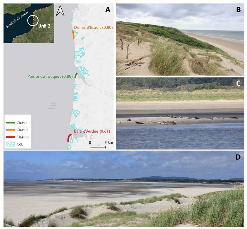
Abstract
“Buy to protect”: this may be the Conservatoire du Littoral philosophy. Since 1975, this unique public French institution endeavours to acquire vulnerable and
threatened coastal areas of great natural relevance to ensure their permanent and sound management/protection by establishing conventions with local
authorities. This paper is focused on (i) the research of remarkable attractive natural sites not (or only slightly) affected by human intrusions, (ii) the analysis
of the Conservatoire policies related to landscape issues and (iii) the proposal of judicious measures to assess/maintain/enhance/monitor landscape quality.
For such proposals, the Coastal Scenic Evaluation System (CSES) method was in situ applied along the northern French coast, from Belgium to the Seine
estuary. This area, shaped in a macrotidal environment, was chosen as it exhibits a wide variety of scenery composed of majestic dunes complexes, estuaries,
bays and impressive cliff formations, alongside a strong cultural heritage. It also includes some world-renowned sites such as Les Deux Caps (Gris-Nez and
Blanc-Nez), the Somme Bay and the cliffs of Étretat. CSES is a strong accurate indicator of scenic quality based on 26 physical and human parameters, and
fuzzy-logic mathematics to overcome subjectivity and quantify uncertainties. As a result, an evaluation index (D) is obtained, enabling to classify sites into
five distinct classes, from Class I (outstanding quality) to Class V (very poor quality). In this paper, 16 sectors respectively located along the Côte d’Opale (8),
Côte Picarde (4) and Côte d’Albâtre (4) were selected after a long process of field testing. Seven were included in Class I, five in Class II and four in Class III.
Finally, suggestions were made to complete the remarkable labour done by the Conservatoire.

1. Introduction
During the last centuries, the coastal zone has represented an attractive and valuable settlement area for humans due to its strategic location, favourable
climate and large quantity of resources (Rick and Fitzpatrick 2012; Ford 2011). Earliest coastal settlements were essentially devoted to agriculture and,
therefore located on coastal plains and deltas, and secondarily to fishing and shellfish harvesting (Erlandson and Fitzpatrick 2006). As civilization advanced
and population grew, coastal areas progressively became a strategic region essentially because of the development of maritime commerce that favoured port
emplacement and associated infrastructures and settlements (Griggs 2017). In the 17th century, started the recreational use of the coastal environment
(Corbin 1993), in France, as in the rest of Europe (Pranzini and Williams 2013), only a few well-established coastal localities existed (Anthony and Sabatier
2012). It was in the 20th century when a wider part of the European population reached an economic level that allowed people to travel for holidays far from
their homes, and beaches came to be considered places of rest and relaxation (Rubio 2005). In France, a further enhancement of coastal tourism took place
after the World War II (WWII), giving way to a new era that transformed coastal areas into places of strong economic value (Houston 2013).

The above brought an increase in coastal population and tourism, according to an incessant and unsustainable feedback process. High-rise hotels and
apartments were built en mass to accommodate seasonal visitors and promenades often replaced areas occupied by traditional fishing boats and small
fishing-related infrastructures (Griggs 2017). About 40% of the present global population is living within 100 km from the shoreline (CIESIN 2012). This trend is
expected to rise as predictions suggest an increase of population living in low elevation coastal zones (< 10m) from 625 million (in 2000) up to 949 and
1388 million people in 2030 and 2060, respectively (Neuman et al. 2015). By 2040, the French coast is expected to increase its population by 4.5 million
inhabitants (MTE 2022).

Travel and tourism represents one of the world’s biggest industries (UNWTO 2020). Before of the Sars-Covid-19 pandemic impact, which produced disruption
globally to people, businesses and economies, tourist arrivals have been continuously growing on the world scale, e.g., in the 2009–2019 period, real growth in
international tourism receipts (54%) exceeded growth in world Gross Domestic Product (GDP, 44%). In 2019, total tourist arrivals were 1.46 billion and
international tourism receipts US$ 1,481 billion, which respectively corresponded to an increase of + 4% and + 3% respect to 2018 (UNWTO 2020). In 2018,
France was the world’s top tourism destination (with 89.4 million arrivals) and the third destination by international tourism incomes (US$ 66 billion), which
contributed to 7% of its GDP (UNWTO 2020). The coast is the first tourist destination in France (MEFR 2021). In 2018, 39% of overnight stays during summer
were recorded at coastal destinations, i.e., 121.8 million nights, with the Mediterranean coast being the most popular (INSEE 2019). Tourism is also relevant
along the southern Atlantic coast as well as the northern littoral and, particularly, the Bay of Somme (Gauche 2017). It constitutes 55% to the Blue economy
jobs and 52% of the Gross Value Added (EC 2020).

Today, tourism industry represents a complex activity, which shows a diversity of cultural, social, environmental and physical aspects. Increased tourism
favours economic development and activities that can give rise to negative impacts on coastal sustainability. Such impacts are often larger than the benefits
that tourism brings (UNEP/MAP/PAP 2008; Holzner 2011; Zielinski et al. 2021): tourism developments are accompanied by decisions essentially based on
financial criteria and no relevance is attributed to coastal environmental preservation and sustainability. According to Lenceck and Bosker (1998), Defeo et al.
(2007), Hughes and Duchain (2011), Pilkey and Cooper (2014), actuations on coastal areas are only carried out when it is mandatory to reduce adverse effects
that threat economic profit and, in most cases, actuations are taken following an action/reaction criteria (Rangel-Buitrago and Anfuso 2015) and not on
economic considerations based on a sound cost–benefit analysis approach (Cooper and McKenna 2008). Today, infrastructures and activities related to
human developments affect an extremely strategic asset—coastal scenery. Coastal landscapes can be described as a littoral area, as perceived by humans,
which is the result from the multiple natural and human factors interactions (Council of Europe 2000). Scenery, which is the focus of this paper, together with
safety, facilities, water quality and no litter represent the five parameters of the greatest significance to coastal visitors (Williams 2011). The invaluable
relevance of coastal scenery to society is reflected by the large number of existing protection status areas, e.g., National Parks, Heritage Coasts, Wilderness
Areas, Protected Landscapes and Areas of Outstanding Natural Beauty. Unfortunately, despite the existence of the above-mentioned features, scenic
degradation globally concerns many coasts as barely 15% of global coastlines remains ecologically undamaged/intact (Williams et al. 2021) and natural
coastal sceneries can be recognised as critically endangered (Pilker and Cooper 2014).

This paper aims to i) identify the most attractive scenic sites of the northern French coast by analysing their physical and human components using the
Coastal Scenic Evaluation System (CSES) method (Ergin et al. 2004, 2006, 2019), ii) analyse the role on coastal scenic beauty preservation of the
Conservatoire du Littoral (CdL, Coastal Conservation Trust or Coastal Protection Agency in English), strongly present along the study area and, in general, in

                                                                            Page 2/28
undeveloped French coastal sectors, and iii) eventually suggest judicious measures to maintain/enhance/monitor scenic quality within determined areas.
Emphasis was given to the Conservatoire as it is a unique public institution committed to protect vulnerable coastal (and lakeshore) areas of great
environmental relevance by purchasing strategies. Its management approach is firmly devoted to preserve and enhance natural beauty of coastal sceneries
and this is focus of this paper.

2. Study Area
The investigated coastline extends ca. 350 km in length from the France-Belgium border to the Seine estuary (INSEE 2015). This macrotidal coast (spring tidal
range is 8–10 meters), bordered by the English Channel and North Sea, includes the Côte d’Albâtre (130 km in length), Côte Picarde (70 km) and Côte d’Opale
(150 km) (INSEE 2015). It presents a remarkable variety of geomorphological features and coastal scenery varying from low-lying areas, dunes, cliffs,
estuaries and bays, amongst others. Cliffs, essentially constituted by chalk, are mainly present along the Côte d’Albâtre and well symbolised by the world-
famous geological features of Etretat (cf Results), which shows arches, stacks, etc. immortalised by many famous artists, e.g., Monet, Delacroix and Courbet
(points 14–16; Fig. 1). The Côte d’Opale and Côte Picarde boast sand and pebble beaches, spectacular dunes system such as the Flanders dunes (point 1 in
Fig. 1), Dunes d’Ecault (8) or Marquenterre (10), wetlands and estuaries, e.g., Platier d’Oye (2), Le Touquet (8) and Baie d’Authie (9), as well as cliffs sectors
composed of marls, clays and limestones (points 3,5,12; Fig. 1). Two emblematic sites of international frame were labelled as Grand Site de France: Les Deux
Caps, referring to Cap Blanc-Nez and Cap Gris-Nez (3–6); and the Bay of Somme (11, Fig. 1). Today, the Conservatoire du Littoral (CdL) protects 39 sites that
occupy 8,000 ha, corresponding to 27% of the Hauts-de-France coastline (CdL 2021a).

Regarding human activities, this region is well-known for its strong shipping industry with its four major ports: Dunkirk (national port for rail freight), Calais
(national passenger port), Le Havre (the second national largest seaport for goods), and Boulogne-sur-Mer (fishing and seafood processing) (MTE 2021). The
tourism industry represents 4% of the Côte d’Opale economy (Pôle Métropolitain de la Côte d'Opale in French) and hosts more than 300,000 tourist beds, i.e.,
almost 50% of Hauts-de-France region capacity (INSEE Hauts-de-France 2021). Since the end of the 19th century, the Côte d’Opale and Côte Picarde have seen
the establishment of numerous seaside towns benefiting due to their proximity to Paris. The successive widespread use of cars for traveling, the improvement
of transport infrastructures, etc., moved tourism to the Mediterranean coast, slowing down tourism growth of northern coastal regions of France.

Actually, among the most famous northern French destinations are Le Touquet-Paris plage, Hardelot, Merlimont, Wissant, Le Crotoy or Mers les Bains. Seaside
resorts along the Côte d’Albâtre frequently stand at the mouth of broad valleys, shaped between the chalk cliffs, e.g., Le Tréport, Dieppe, Fécamp and Etretat;
most of them were ancient fishing village. At Côte d’Opale and Côte Picarde, tourism employs around 10,000 jobs per month, i.e., 3.9% of total employments
(regional average is 2.4%); whilst, at Côte d’Albâtre, tourism generates nearly 5,000 jobs/month (INSEE 2015). With 10 million visits in summer, its high
seasonality is associated with its climate categorised as “Temperate oceanic” (Cfb; Köppen classification) (Kottek et al. 2006). An incessant growth in
popularity has been recorded in the past twenty years, i.e., an 8.9% rise between 2018 and 2019 in Haut-de-France (INSEE 2015, 2019).

Lastly, a strong cultural heritage, essentially linked to remains of the WWII, is observed along the coast of these two regions. Ruins of blockhouses, one time
located on dunes, are nowadays on the shore, this clearly reflecting shoreline retreat in the last decades. Places such Baie de Wissant (point 4; Fig. 1)
experienced > 100 m retreat between 1963 and 2000 (Aernouts and Héquette 2006; Chaverot 2006). At Bois de Cise (point 12; Fig. 1), cliffs are retreating at a
rate > 0.50 m/yr (Pannet et al. 2014).

3. Method
Coastal scenic characteristics were field-tested at 16 sites by applying the well-known “Coastal Scenic Evaluation System” (CSES), published in British Council
Reports (BCR 2003, 2004), Ergin et al. (2004, 2006) and Rangel-Buitrago (2019), formulated from a pilot idea by Morgan and Williams (1995). The CSES
methodology was formulated by expert and trained groups on coastal geomorphology and management via a public survey evaluation process to establish
the best/ugliest coastal scenery. In a preliminary step (BCR 2003), a large list of scenic parameters was selected by literature surveys, interviews and
consultancy with coastal experts, professionals and academicians and > 1000 questionnaires to beach users, chosen by random number tables at selected 57
sites in Croatia, Malta, Turkey and UK. Assessment results allowed to select the number of times a parameter was marked, and the answers pointed out 26
“coastal scenic assessment parameters”, 18 physical and 8 human (Table 1). Successively, > 500 beach interviews were undertaken in the same countries to
give a score to each one of the 26 parameters obtained during the first round of surveys. This enabled the establishment of a weight for each parameter, i.e.,
not all parameters had the same value. After that, each parameter was ranked from low (1), i.e., absence/poor quality, to high (5), i.e., excellent/outstanding
quality.

A mathematical model based on Fuzzy Logic Approach (FLA) (Patel 2002) was developed to reduce the possibility of the scenic value assessor marking the
wrong attribute box in the 26 parameters checklist, e.g., cliff slope can be < 45º (rated 1), 45–60º (rated 2), 60–75º (3), 75–85º (4) or circa vertical (5) (Table
1). The FLA allows overcoming the problem, e.g., a cliff slope being recorded in the 75–85º box (4) when, in reality, it is circa vertical (5). The method is
explained in detail by Ergin (2019).

Ones the checklist is filled, results are graphically shown as histograms, weighted average of attributes and membership degree of attributes (Ergin 2019). A
visual summary of scores of physical and human parameters is represented by histogram figures that easily assess high/low rated attributes. Membership
degree vs. attribute curve corresponds to overall scenic assessment over the attributes, and weighted averages of attributes define relative assessment of
physical and human parameters. Based on summed parameter evaluations, a final “D” score is computed, which divides sites into five distinct classes, from
Class I (extremely attractive natural sites) to Class V (very unattractive, intensively developed urban sites).

The CSES method was successfully tested in many field-studies carried out in numerous countries —>30, see Anfuso et al. (2019) for a detailed description of
> 1000 global study cases. It provides an evidence–based approach for sound coastal management decisions since it gives not only an objective evaluation

                                                                            Page 3/28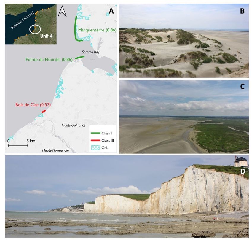
of the physical but also of human parameters (unattractive urbanization, intensive and not environmental friendly developments, presence of litter, etc.).
Therefore, CSES also points out how scenic parameters may be improved by sound management actions − especially human parameters because it is not
easy to improve natural ones.

The focus of this paper is research on the top scenic sites lying in Class I (D ≥ 0.85) and Class II (0.65 ≤ D < 0.85), with null or very low level of human
influence, and essentially located in remote areas. For a few reasons (further discussed), this study also includes a few Class III sites. Selection of sites was
realized according to the same standard applied in Bulgaria, the Balearic Islands and Andalusia, Spain (Mooser et al. 2018, 2021, 2022), detailed in the
following lines:

  i. A first approximation of the most attractive coastal sectors was achieved via satellite images and land-cover viewers, e.g., Google Earth and Copernicus
    land viewer. This enabled elimination of urban and village areas, and to preselect natural areas (or rural) that appeared of great scenic value conforming
    to the 26 physical and human parameters (Table 1), and accessible by a walk  1.5 h).

                                                                              Page 4/28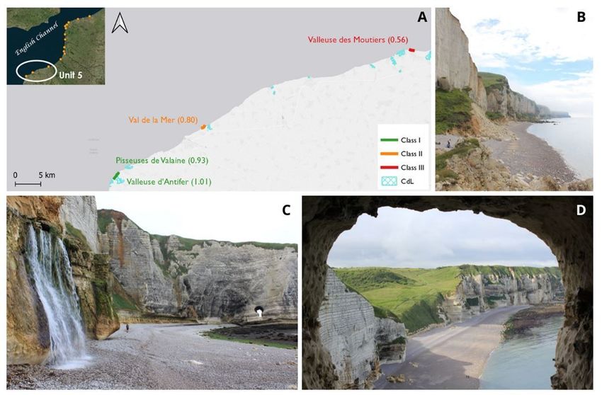
Table 1
                                         Physical and human parameters for scenic beauty assessment (CSES method)
No    PHYSICAL                    Weight      RATING
      PARAMETERS
                                              1                 2                      3                                     4                 5

1                  Height (m)     0.02        Absent            5 ≤ H < 30             30 ≤ H < 60                           60 ≤ H < 90       H ≥ 90

2     CLIFF        Slope          0.02        < 45º             45°–60º                60°–75º                               75°–85°           circa vertical

3                  Features*      0.03        Absent            1                      2                                     3                 Many (>3)

4                  Type           0.03        Absent            Mud                    Cobble/Boulder                        Pebble/Gravel     Sand

5     BEACH        Width (m)      0.03        Absent            W < 5 or               5 ≤ W < 25                            25 ≤ W < 50       50 ≤ W ≤ 100
      FACE
                                                                W > 100

6                  Colour         0.02        Absent            Dark                   Dark tan                              Light             White/gold
                                                                                                                             tan/bleached

7                  Slope          0.01        Absent            < 5°                   5°–10°                                10°–20°           20°–45°

8     ROCKY        Extent         0.01        Absent             20 m
      SHORE

9                  Roughness      0.02        Absent            Distinctly jagged      Deeply pitted and/or irregular        Shallow           Smooth
                                                                                                                             pitted

10    DUNES                       0.04        Absent            Remnants               Fore-dune                             Secondary         Several
                                                                                                                             ridge

11    VALLEY                      0.08        Absent            Dry valley             (< 1 m) Stream                        (1–4 m)           River/limestone
                                                                                                                             Stream            gorge

12    SKYLINE LANDFORM            0.08        Not visible       Flat                   Undulating                            Highly            Mountainous
                                                                                                                             undulating

13    TIDES                       0.04        Macro (>4 m)                             Meso (2–4 m)                                            Micro (3
      FEATURES**

15    VISTAS                      0.09        Open on one       Open on two sides                                            Open on three     Open on four
                                              side                                                                           sides             sides

16    WATER COLOUR &              0.14        Muddy brown/      Milky blue/green       Green/grey/ blue                      Clear             Very clear
      CLARITY                                 grey              opaque                                                       blue/dark         turquoise
                                                                                                                             blue

17    NATURAL VEGETATION          0.12        Bare (50 cm high)

      HUMAN PARAMETERS

19    NOISE DISTURBANCE           0.14        Intolerable       Tolerable                                                    Little            None

20    LITTER                      0.15        Continuous        Full strand line       Single accumulation                   Few scattered     Virtually absent
                                              accumulations                                                                  items

21    SEWAGE DISCHARGE            0.15        Sewage                                   Same evidence (1–3 items)                               No evidence of
      EVIDENCE                                evidence                                                                                         sewage

22    NON_BUILT                   0.06        None                                     Hedgerow/terracing/monoculture                          Field mixed
      ENVIRONMENT                                                                                                                              cultivation ±
                                                                                                                                               trees/natural

23    BUILT ENVIRONMENT           0.14        Heavy Industry    Heavy tourism          Light tourism and/or urban            Sensitive         Historic and/or
                                                                and/or urban           and/or sensitive                      tourism           none
                                                                                                                             and/or urban

24    ACCESS TYPE                 0.09        No buffer         No buffer                                                    Parking lot       Parking lot not
                                              zone/ heavy       zone/light traffic                                           visible from      visible from
                                              traffic                                                                        coastal area      coastal area

* Cliff special features: indentation, banding, folding, screes and irregular profile. ** Coastal landscape features: Peninsulas, rock ridges, irregular
headlands, arches, windows, caves, waterfalls, deltas, lagoons, islands, stacks, estuaries, reefs, fauna, embayment, tombola, etc. *** Utilities: power lines,
pipelines, street lamps, groins, seawalls, revetments, restaurants, etc.

                                                                           Page 5/28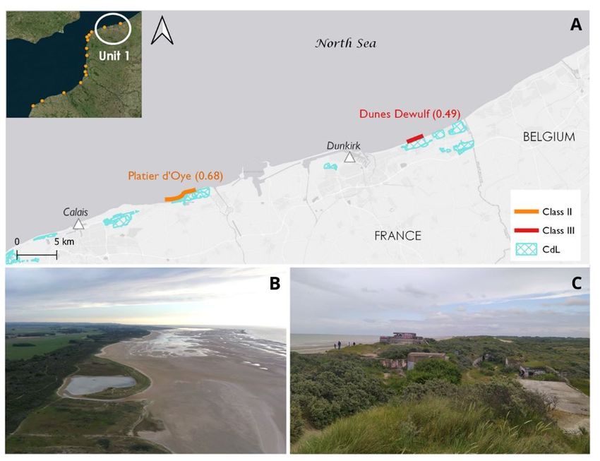
No      PHYSICAL                     Weight     RATING
         PARAMETERS
                                                 1                    2                 3                                      4                 5

 25      SKYLINE                      0.14       Very                                   Sensitively designed high/low          Very              Natural/historic
                                                 unattractive                                                                  sensitively       features
                                                                                                                               designed

 26      UTILITIES***                 0.14       >3                   3                 2                                      1                 None

 * Cliff special features: indentation, banding, folding, screes and irregular profile. ** Coastal landscape features: Peninsulas, rock ridges, irregular
 headlands, arches, windows, caves, waterfalls, deltas, lagoons, islands, stacks, estuaries, reefs, fauna, embayment, tombola, etc. *** Utilities: power lines,
 pipelines, street lamps, groins, seawalls, revetments, restaurants, etc.

4. Contextualisation
4.1 French national context
With nearly 11 million km2 and almost 20,000 km of coastline, France has the second largest maritime space in the world after the United Stated (MTE 2017).
Because of the wide distribution of its overseas territories, France jurisdiction is presented in all seas and oceans (except the Arctic) and this makes this
country custodian of an extraordinary natural heritage, e.g., 10% of world coral reefs and 20% of atolls are located under French jurisdiction (MEDDE 2014).

Coastal management is basically under the responsibility of the national government. Nonetheless, a national level consultation on a new environment policy
(Grenelle de l’environnement between 2007 and 2010) placed more emphasis on the decentralization and integrated management of the seas and coasts
(Grenelle II Law 2010). This process has not yet been successfully achieved (Cudennec 2020) but certain services have been decentralised to NUTS 2 (Région
in French) and NUTS 3 (Département) levels. A meaningful step is the National Strategy for the Sea and Coast adopted and launched in 2017 (MTE 2017),
which fits with the Integrated Maritime Policy adopted by the European council in 2007 (EC 2007).

France was not one of the first countries aware of the necessity of preserving natural coastal sites. For example, British countries and The Netherlands were
pioneers in adopting laws and taking measures on coastal issues (Meur Férec 1997). However, coastal protection and preservation in France became a priority
as a result of a strong set of legal tools established over the 20th and 21st centuries. Below, the most relevant ones:

  i. Law of 2nd May 1930, to protect remarkable natural and cultural sites (Site classé and Site inscrit in French). These terms are widely used to protect
     coastal sites;
  ii. Decree no. 59-771 (1959), to establish “Sensitive perimeter” (Périmètres sensibles) within coastal areas, and particularly along the southern Côte d’Azur
      (extended in 1961 to the whole territory);
 iii. Law no. 60-1384 (1960) with the institution of the “Department green tax” (Redevance Départementale d’Espaces Verts) to intervene in favour of the
      protection of coastal sites;
 iv. Law no. 60-708 (1960) for the creation of National parks;
  v. Law no. 75-602 (1975), foundation of the Conservatoire de l’Espace Littoral et des Rivages Lacustres, generally called Conservatoire du Littoral, which is
     the focus of this paper;
 vi. Law no. 76-629 (1976), a fairly innovative nature protection Law for the conservation of natural habitats and wildlife that particularly enabled the creation
     of nature reserves;
 vii. Law no. 86-2 (1986) known as “The Coastal Law” (Loi Littoral, modified in 2018), relative to coastal management, protection and planning, which marks
     a turning point in coastal management, especially for natural coastal sites;
viii. Decree no. 89-684 (1989), related to the Coastal Law, to specify “Special sites” of high ecological value (Espaces remarquables) to be delimited in the
      Land Use Plan (Plan d’Occupation des Sols) of the Communes within strict legal protection
 ix. Law no. 93-24 (1993), the Landscape Law (Loi Paysage), which devoted a specific approach to the aesthetic and heritage value of sceneries;
  x. Law no. 2006-436 (2006) related to national and regional natural parks together with marine natural parks;
 xi. the "Grenelle Environment Round Table" commitments (2007), to define the key points of public policy on ecological and sustainable development issues,
      i.e., a "National strategy of sustainable development towards a green and equitable economy" entered in force in 2010;
 xii. Law no. 2016-1087 (2016) for the recovery of biodiversity, nature and landscape, establishing, amongst others, a national biodiversity committee and
      agency for Biodiversity (Office français de la biodiversité).

France also demonstrated its leadership role on climate change issues, e.g., by leading the Paris Agreement (2015) and the Global Pact for the Environment
(2017). In recent years, a “National Protected Areas Strategy 2030” was launched with the aim of unifying, for the first time, all protected areas, natural land
and marine heritage in metropolitan France and overseas territories (MTE/MM 2021). This new strategy included seven main objectives, which come with 18
measures, implemented by means of three successive three-year action plans terminating in 2030. Among the most significant measures, it expects to expand
by 2022 the Protected Area network to, at least, 30% of the national territory and have 10% of it under any high protection feature.

4.2 Conservatoire du Littoral
Many British initiatives, like Heritage Coasts and the National Trust, have inspired French policy, notably in the foundation of the Conservatoire du Littoral
(CdL). Likewise, France has endowed itself with a strong set of laws for the protection of the coastal zone, which has no equivalent in England and Wales. A

                                                                           Page 6/28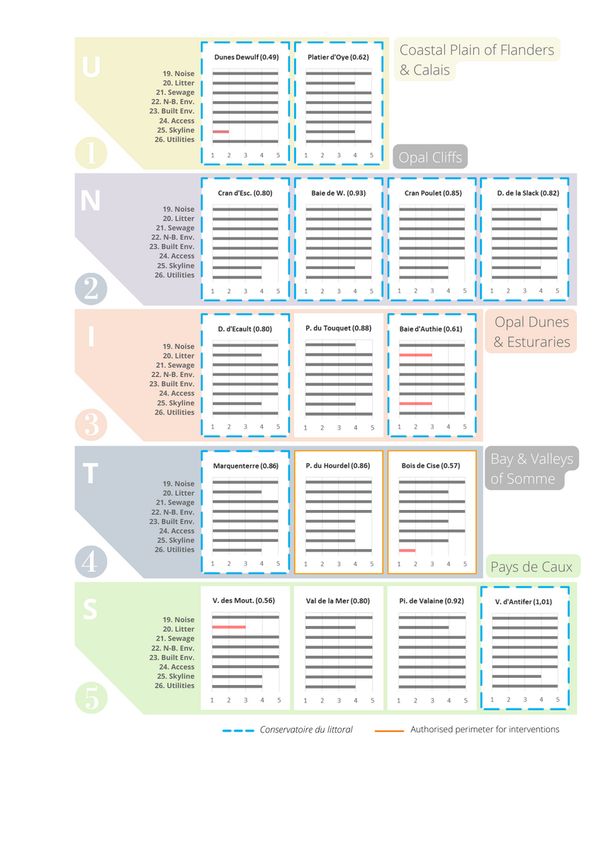
very detailed comparison between the French and British systems can be found in Meur Férec (1997). By means of the CdL, the French system places
emphasis on land acquisition while British organizations mostly operate through specific agreements set up with private landowners (Williams 1990, Meur
Férec 1997; AONB 2019; National Trust 2022).

Created in 1975 (Law No. 75–602), the Conservatoire is a public institution without any equivalent institution in Europe (Meur Férec 1997; Kalaora and Konits
2004; IUCN 2013; Joveniaux 2017) whose mission is to acquire vulnerable and threatened coastal and extensive lakeshore areas of great natural relevance to
ensure their permanent protection. This marks a significant turning point in the history of management of French coastal areas. The aim is to protect the
beauty of landscapes and their ecosystem diversity, by ensuring also a free and sustainable public access to them. Land-purchasing policy is guaranteed by
State subventions —such is not the case of British organisations cited before— and by private donors, e.g., firms or individuals. Only in 2020, the CdL received
51.7M€ of which 37.5M€ came from a boat tax known as “Francisation” (Droit Annuel de Francisation et de Navigation DAFN in French). For the same period,
private donations were estimated over 3,2M€ alongside the endowment of 15 parcels (89 ha), valued for ca. 1.35M€ (CdL 2021b). Since its creation, almost
3,000 ha have been acquired every year (> 8700 deeds of sale) and, today, nearly 14% of the French coastline is protected under this system (750 sites
occupying 210,000 ha) (CdL/MTE 2021). In certain regions such as Nord-Pas de Calais and Corsica, circa 25% of the coastline already belongs to the
Conservatoire (CdL/MTE 2015).

The above lead to the following question: how does the Conservatoire identify areas of intervention? Whilst, the sole criterion of UK Heritage Coats is scenic
beauty, the answer herein demands a holistic view of the following issues (CdL/MTE 2015):

   i. Ecological value,
  ii. Landscape and cultural heritage,
 iii. Land-sea interface,
 iv. Level of human pressure,
  v. Lack of management, and
 vi. risk of overcrowding scenarios.

Adopted by the French council, the “Intervention Strategy” on the horizon 2050 (Stratégie d’intervention 2015–2050 in French) aims to:

   i. contribute to the “Third wild”, i.e., the protection of one-third of the French coastline, target set by the CdL in line with the National Protected Areas
    Strategy (MTE/MM 2021) —which also includes in its scheme the coastlines protected by national parks, nature reserves, public-owned forests and
    sensitive natural areas— and
  ii. create a network of natural sites in healthy conditions, valued as an integral part of the territories, with long-tern management plans and adaptation
      strategies to climate change related processes.

To complete the first objective, a series of maps database/strategies (Stratégies cartographiées or Carte d’enjeux et de pressions in French) were initially
established for the 146 French coastal units in 1995 and then updated in 2005 and 2015. This enabled to identify two different types of areas: i) priority areas
for interventions and ii) surveillance areas, both detailed in territorial project at coastal units’ level. This information is frequently revised and shared with both
territorial partners and the administration council of the CdL with the aim of establishing which surfaces (named “authorised perimeter”) have to be acquired
within such areas. Often, the assignment of coastal lands belonging to the public domain is solicited by the CdL. Between 2005 and 2015, 93% of acquisitions
were realised within these strategic areas declared in 2005 as “authorised perimeter” (CdL/MTE 2015). Therefore, to reach the first-mentioned objective (i.e.,
the “Third wild”), the “Intervention Strategy 2015–2050” expects to protect 320,000 hectares (nearly 1000 sites), by private acquisitions (200,000 ha) and
public assignations (120,000 ha), i.e., about 20–25% of the French coastal length (CdL/MTE 2015).

The second objective aims to draw up durable management plans for all acquired sites. The openness and the quality of interventions have to contribute to
restore/preserve their natural identity by conserving/encouraging traditional activities and allowing only very limited and supervised leisure facilities. Although
the Conservatoire is guarantor of the smooth functioning of its properties, it does not carry out their day-to-day running: once a site or property is acquired,
management partnerships are set up primarily with local authorities to cultivate a local sense of ownership. An agreement by conventions is thus reached on
strategies to adopt according to the Conservatoire chart (further analysed) and diagnostics previously established. Competencies between CdL (owner) and
managers are presented in Fig. 2.

Today, the CdL is associated with more than 330 managers, i.e., among them, 50% are Communes (Municipalities), 31% departments (and structures
intercommunales) and 15% associations (NGOs) (CdL 2021b). Nearly 65% of sites (485 out of 750) are considered as “operational” or “working” sites because
show full management plans with long-term adaptation strategies. By 2050, it expects to reach roughly 1000 “operational” sites. Otherwise, the fact that sites
protected are totally excluded from the real estate market further contributes to increase the value of adjoining residential areas (Prunetti et al. 2011), as is the
case with Heritage coasts in England and Wales. Surveys carried out in 2011 showed that almost 95% of French peoples considered the interventions of the
Conservatoire to be necessary (CdL 2016).

5. Results
In order to achieve the objectives initially proposed, investigated sectors were classified and analysed in detail by coastal units (unités littorales in French)
established by the CdL, to deal with management challenges at local scales. The metropolitan French territory is divided into a total of 93 coastal units,
characterized by a certain geographical, historical or cultural homogeneity. In total, five were identified along the 350 km of the study area and investigated
below:

                                                                              Page 7/28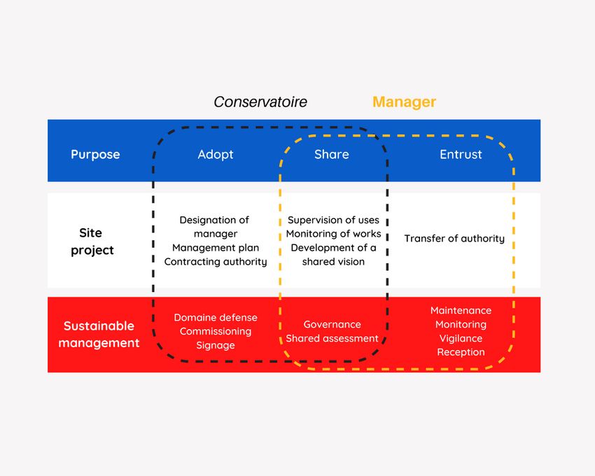
i. Coastal Plain of Flanders and Calais (Plaine Maritime de Flandre et du Calaisis in French)
  ii. Opal Cliffs (Falaise d’Opale)
  iii. Opal Dunes and Estuaries (Dunes et Estuaires d’Opale)
  iv. Bay and Valleys of Somme (Baie et Vallées de la Somme)
  v. Cliffs and Valleys of Pays de Caux (Falaises et Valleuses du Pays de Caux)

Sixteen sites, respectively located along these five units, were field tested during July (2021) by the itemised checklist method (Ergin et al. 2004, 2006) (Table
1). Their scenic attractiveness is reflected by the Evaluation index scores (D) presented in Fig. 3. Seven sites correspond to Class I (D ≥ 0.85), five to Class II
(0.65 ≤ D < 0.85) and four to Class III (0.40 ≤ D < 0.65). Certain sites clearly stand out from the rest with very high scenic values such as Valleuse d’Antifer (D:
1.01), Pisseuses de Valaine (0.92), Baie de Wissant (0.93) or Pointe du Touquet (0.88) (Fig. 3). Others showed medium or poor scores for human aspects and
were consequently ranged in Class III. Regarding Baie d’Authie and Valleuse des Moutiers (Class III), both could be easily upgraded to Class II just by reducing
beach litter amounts.

As shown in Table 2, all investigated sectors are located within protected areas under complementary designations features established at regional, national,
European or international levels, working alongside the Conservatoire. The European project recently initiated by the CdL at Baie d’Authie (Life Adapto 2022),
which marks the border between the Opal and Alabaster coasts, is a great symbol of cooperation. It gathers together numerous partners (department, Regional
Natural Park, local communities, amongst others) in an attempt to reach a balance among traditional uses, conservation of biodiversity and ecotourism
development.

Regarding the sites investigated, 10 out of 16 are under the control of the Conservatoire (Table 2). At various places, “authorised perimeters” have been set up
to:

      i. Fully control the whole site by acquiring the little remaining surface; i.e., Marquenterre, Baie de Wissant, Platier d’Oye and Dunes d’Ecault,
  ii. Protect new sites such as Pointe du Hourdel or Bois de Cise (Table 2).

Places like Pointe du Touquet and Pisseuses de Valaine (both Class I) have not been placed within such priority perimeters. It is certainly because the former is
already a Site Classé (with a strong protection feature) while the latter is backed, on its cliff top, by a golf course since 1908.

                                                                               Page 8/28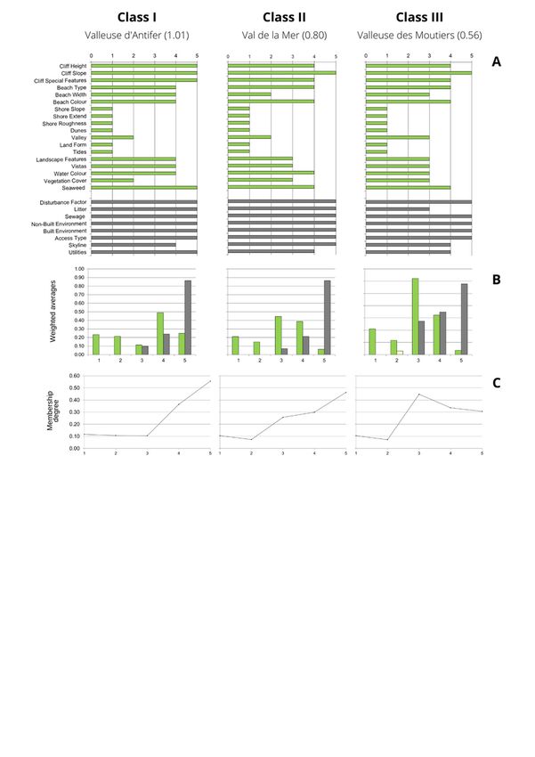
Table 2
  Main site characteristics: municipalities, beach typologies, beach length, Conservatoire and other protected area features, D values and scenic classes
Site                     Municipality             Typ.*     Length     D        Class    CdL (%)             Protected Areas
                                                            (m)
                                                                       value             Acq.**    Per.***

(1) Dune Dewulf          Leffrinckoucke           Re        2,280      0.49     III      100                 SAC & SPA

                         Ghyvelde

(2) Platier d’Oye        Oye-Plage                Re        3,600      0.68     II       75        25        Réserve Naturelle Nationale

                                                                                                             SPA

(3) Cran d’Escalles      Escalles                 Re        1,730      0.80     II       100                 Grand Site de France (GSF) Les Deux Caps
                                                                                                             Regional Natural Park (RNP) Caps et Marais
                                                                                                             d’Opale
                                                                                                             APB Cap Blanc Nez

                                                                                                             SAC & SPA

(4) Baie de Wissant      Wissant                  Re        1,790      0.93     I        70        30        GSF Les Deux Caps

                                                                                                             RNP Caps et Marais d’Opale

                                                                                                             SAC & SPA

(5) Cran Poulet          Audinghen                Re        720        0.85     I        100                 GSF Les Deux Caps

                                                                                                             RNP Caps et Marais d’Opale

                                                                                                             SAC & SPA

(6) Dunes de la Slack    Wimereux                 Ru        1,460      0.82     II       100                 GSF Les Deux Caps

                                                                                                             RNP Caps et Marais d’Opale

                                                                                                             Marin Natural Park (MNP) Estuaires Picards
                                                                                                             et Mer d’Opale (MO.)

                                                                                                             SAC & SPA

(7) Dunes d’Écault       Saint Étienne au         Re        2,250      0.80     II       70        30        RNP Caps et Marais d’Opale MNP Estuaires
                         Mont                                                                                Picards et MO.

                                                                                                             SAC

(8) Pointe du            Le Touquet-Paris-        Ru        1,450      0.88     I        No                  Site classé
Touquet                  Plage
                                                                                                             MNP Estuaires Picards et MO.

                                                                                                             SAC & SPA (only marine)

(9) Baie d’Authie        Fort-Mahon-Plage         Re        2,170      0.61     III      100                 Ramsar

                                                                                                             RNP Baie de Somme Picardie Maritime (PM.)

                                                                                                             MNP Estuaires Picards et MO.

                                                                                                             SAC & SPA

(10) Marquenterre        Saint-Quentin-en-        Re        7,800      0.86     I        70        30        Ramsar
                         Tourmont
                                                                                                             National Natural Reserve

                                                                                                             RNP Baie de Somme PM.

                                                                                                             MNP Estuaires Picards et MO.

                                                                                                             SAC & SPA

(11) Pointe du           Cayeux-sur-Mer           Ru        1,420      0.86     I                  100       Ramsar
Hourdel
                                                                                                             APB

                                                                                                             RNP Baie de Somme PM.

                                                                                                             MNP Estuaires Picards et MO.

                                                                                                             SAC

* Beach typologies defined according to Williams et al. (2011); **surface acquired by the CdL;

*** surface declared as “authorised perimeter” by the CdL

                                                                       Page 9/28
Site Municipality Typ.* Length D Class CdL (%) Protected Areas
(m)
value Acq.** Per.***
(12) Bois de Cise Ault Ru 950 0.57 III 80 Ramsar
RNP Baie de Somme PM.
MNP Estuaires Picards et MO.
SAC
(13) Valleuse des Varangeville-sur-Mer Re 810 0.56 III No OSPAR (marine)
Moutiers
SAC
(14) Val de la Mer Senneville-sur- Ru 490 0.80 II No OSPAR (marine)
Fécamp
SAC & SPA
(15) Pisseuses de Étretat Re 350 0.92 I No OSPAR (marine)
Valaine
SAC & SPA
(16) Valleuse Le Tilleul Re 750 1.01 I 100 Site Classé
d’Antifer
OSPAR (coastal and marine area)
SAC & SPA
* Beach typologies defined according to Williams et al. (2011); **surface acquired by the CdL;
*** surface declared as “authorised perimeter” by the CdL
5.1 Analysis of physical parameters by coastal units
These five coastal units stands out as having a large scenic variety that inspired and amazed countless recognised artists, poets and novelists, such as
Delacroix, Boudin, Courbet, Pissarro, Matisse, Maupassant, Hugo and Verne. A land composed of estuaries, dunes, sand beaches and chalk cliffs, shaped in a
macrotidal environment by strong winds prevailing from the SW, where lights and colour contrasts are continuously changing. The Côte d’Albâtre and Côte
d’Opale owe their name to the stone opal colour, for its opalescence, fluorescence and iridescence, and the whiteness of the alabaster, which varies depending
on weather conditions. Below, a description of physical scenic characteristics is given for each coastal unit and scores obtained from the CSES parameters are
presented in Table 3.
Page 10/28Table 3
Site scores obtained for physical (1–18) and human parameters (19–26) (CSES parameters)
Parameter 1. 2. 3. Cran 4. Baie 5. 6. 7. 8. 9. Baie 10. 11. 12.
Dunes Platier d’Escalles de Cran Dunes Dunes Pointe d’Authie Marquenterre Pointe Boise
Dewulf d’Oye (0.80) Wissant Poulet de la d’Écault du (0.61) (0.86) du de
(0.49) (0.68) (0.93) (0.85) Slack (0.80) Touquet Hourdel Cise
(0.82) (0.88) (0.86) (0.57)
1–3 Height 1 1 4 1 2 1 1 1 1 1 1 4
Cliff
Slope 1 1 4 1 4 1 1 1 1 1 1 5
Features 1 1 4 1 5 1 1 1 1 1 1 4
4–6 Type 5 5 4 5 4 4 5 5 5 5 4 3
Beach Width 3 1 1 3 3 3 4 2 2 3 3 2
face
Colour 4 4 4 5 3 4 4 5 4 4 4 4
7–9 Slope 1 1 1 1 1 1 1 1 1 1 1 3
Rocky Extent 1 1 1 1 1 1 1 1 1 1 1 5
shore
Rough. 1 1 1 1 1 1 1 1 1 1 1 4
10. Dunes 5 3 1 4 1 5 5 5 5 5 3 1
11. Valley 1 1 2 1 2 1 4 5 5 1 5 1
12. Skyline 1 1 1 1 1 1 1 3 1 1 1 1
landform
13. Tides 1 1 1 1 1 1 1 1 1 1 1 1
14. Landscape 1 3 4 4 3 3 1 4 4 3 3 3
features
15. Vistas 4 5 4 4 4 4 4 4 4 4 4 4
16. Water colour 3 3 3 3 4 3 3 3 3 4 3 3
17. Vegetation 4 3 1 4 3 4 4 3 3 3 4 3
cover
18. Vegetation 5 5 5 4 5 4 4 5 5 4 5 5
debris
19. Noise 5 5 5 5 5 5 5 4 5 5 5 5
disturbance
20. Litter 5 4 5 5 5 4 4 5 3 4 5 4
21. Sewage 5 5 5 5 5 5 5 5 5 5 5 5
evidence
22. Non-Built 5 5 5 5 5 5 5 5 5 5 5 5
Environment
23. Built 5 5 5 5 5 5 5 5 5 5 4 4
environment
24. Access type 5 5 5 5 5 5 5 5 5 5 4 5
25. Skyline 2 4 4 4 4 4 4 4 3 5 4 4
26. Utilities 5 5 4 5 4 5 5 5 5 4 5 2
a) Coastal Plain of Flanders and Calais
From Calais to Belgium, along the coast of the North Sea, this long fringe of low-lying landforms spread over 10 to 15 km inland. It mainly consists of sand
dunes, estuaries and “polders”. The latter is a Dutch word generally used to designate a piece of land reclaimed from the sea or from inland water bodies
(Eisma 1982). This cultural landscape has been shaped over the centuries by local inhabitants for farming activities such as pasture or market gardening.
Two sites owned by the CdL are part of this coastal unit (Fig. 4A): Platier d’Oye (D: 0.68; Class II) and Dunes Dewulf (0.49; Class III). Good scores, linked to the
geomorphological setting, were observed at both sites, i.e., beach type/colour and presence of dunes (Table 3). The former is a nature reserve constituted by
an extensive coastal lagoon (Fig. 4B) and one of the largest birds feeding area on the English Channel and North Sea, and more than 230 bird species have
been observed (RNF 2022). This was reflected by good scores for “Landscape features” (point 14; Table 3). Situated close to the boarder with Belgium, the 275
ha occupied by the Dune Dewulf complex stretches along nearly 2.5 km of coastline and is part of a vast dune complex called “The Dunes of Flanders”. It
represents a characteristic geomorphologic feature of the North Sea coast, formed by prevailing winds striking the shoreline obliquely from the SW and
Page 11/28presenting vast depressions (blow outs) in the heart of the dune complex (Fig. 4C). Scenic quality of the Dunes Dewulf complex is significantly lowered by the
proximity of Dunkirk (cf discussion). Today, the Conservatoire holds eight protected areas in this coastal unit.
b) Opal Cliffs
West of Calais, dunes give way to the famous Grand Site de France des Deux Caps, a true natural setting recognised by a national label in 2011 (renewed in
2018) consisting of two capes. The geology of this site explains its landscape diversity. Four investigated sites fall within this coastal unit and all belong to
the Conservatoire: Cran d’Escalles (D: 0.80), Dune d’Aval (0.91), Cran Poulet (0.85) and Dune de la Slack (0.65) (Fig. 5A). The “Two Caps” are made up of a
succession of grey Jurassic cliffs, composed of marls and sandstones (Cap Gris-Nez) (Fig. 5D), and white chalky cliffs from the Cretaceous period (Cap
Blanc-Nez) (Fig. 5B), and dune sequences alongside a wide opening bay bordered by two capes (Fig. 5C).
The grey cliffs of Cap Gris-Nez give the cape its name (Grey Nose in English). Cran Poulet, a pebble beach located southern of Gris-Nez, is a perfect place to
collect fossils such bivalves, gastropods or ammonites of Jurassic age. These singular cliffs’ characteristics were reflected by top scores for “Cliffs Special
Features” (rated 5; Table 3). From Cran d’Escalles, it is possible to observe the well-known Cap Blanc-Nez (White Nose in English), reaching a height of 134 m
and favouring top grade scores for “Cliff Height” (> 90 m, rated 5; Table 3). “Cran” is a local term, specific to the Opal coast, to designate “small cliff valley”
shaped by water runoff (“Valley”, rated 2; Table 3). South from the eponym village, Baie de Wissant is also known as Dunes d’Aval and backed by a 100–350
m dune width complex varying from 6 to 22 m in height (rated 5; Table 3). Critically exposed to erosion processes, this latter experienced a retreat > 100 m in
the last decades (Aernouts and Héquette 2006; Chaverot 2006). At low tide, the beach foreshore is 400–500 m wide whilst the upper beach is nearly 20 m
(rated 3; Table 3). It consists of fine homogeneous well-sorted sands, i.e., 0.25 mm (Ruz and Meur-Férec 2003), giving top scores at “Beach type” (fine sand,
rated 5; Table 3) and “Beach colour” (gold, rated 5; Table 3). These three very attractive sites (two Class I and one Class II) are also located in the closest point
to England (34 km). On a clear day, the emblematic white chalky cliffs of Dover can be seen, favouring good scores for “Landscape Special Features” (Table
3). Dune de la Slack is another great scenic site (D: 0.82), located at the south of the Slack River, surrounded by a remarkable 213 ha developed dune complex
(rated 5) (Fig. 5E).
c) Opal Dunes and Estuaries
South of Boulogne, this coastal unit is characterized by sand beaches, immensely wide at low tide, outstanding dune systems and estuaries. These
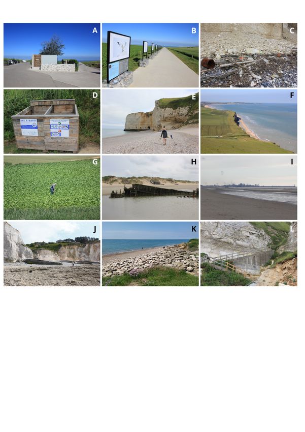
landscapes are well exemplified by the following investigated sites: Dune d’Ecault (D: 0.80), Pointe du Touquet (0.88) and Baie d’Authie (0.61) (Fig. 6A-D).
Mostly acquired by the CdL, the former is a patchwork of dunes systems. With nearly 5 km width (the largest dune massif in northern France), it shows embryo
dunes, white dunes with European marram grass (Ammophila arenaria), gray dunes with mosses and lichens, shrubby dunes and wooden dunes (rated 5;
Table 3) (Fig. 6B). Good ratings were generally observed for “Beach characteristics” as sand comes from the extensive Palaeocene and Eocene deposits (from
the sea) rather than from rivers (Briquet 1930). At Pointe du Touquet, its gold/white tan colour gives top score for “Beach colour” (Table 3). Together with the
Authie Bay, the Canche Bay is a typical “Picardy estuary”: on one side, an accreting shore known as the poulier (sandspit), which corresponds with the Pointe
du Touquet (Fig. 6D), and on the other side, a strong eroding sector (musoir in French). Both sites record complex sedimentary exchanges and offer a wide
variety of ecosystems, i.e., dunes, polders, salt meadows, bocage, meadows and ponds hosting a great biodiversity of flora and fauna (Fig. 6C). This set of
characteristics favours excellent scores for “Landscape Special Features” (both rated 4), “Dunes” and “Valleys” (both rated 5, Table 3). Besides, at Pointe du
Touquet, the undulating landscape of the Canche Bay gives intermediate score for “Landform” (rated 3, Table 3). Labelled as Site Classé in 2001 (Classed
Site), this latter is one the most aesthetic site of this paper, whilst Baie d’Authie only figures as a Class III site. This latter is further discussed in order to
analyse the ways to upgrade it to Class II.
d) Bay and Valleys of Somme
This coastal unit is especially well known for its world famous Baie de Somme (“Somme Bay” or “Bay of the Somme”). But it is also one of the most varied in
term of scenery. Once again, this diversity is perfectly represented by the investigated sites: Marquenterre (0.86, Class I), Pointe du Hourdel (0.86) and Bois de
Cise (0.57, Class II) (Fig. 7A-D). North to the bay, Marquenterre is characterized by a remarkable mosaic of dune formations (rated 5, Table 3), i.e., white dunes,
grey dunes, shrubs, dune clacks and pine forests, over a surface area up to 3,000 ha (3 km wide) and 14 km of unspoilt coastline. This highly protected
complex (National Nature Reserve), known as “Picardy dunes”, is typical of this region and characterized by wide dune formations due to the perpendicular
prevailing winds (Fig. 7D). Most of the Marquenterre coastline is also owned by the CdL. The Somme Bay represents the largest estuary in northern France,
with a surface of 7,200 ha, only 15% of which has been urbanised (World Bays 2022) (Fig. 7C). This Grand Site de France is also the refuge of a very rich
fauna with 365 bird species identified and the largest French colony of harbour seals (RSIS 2022). Mainly composed of vast sand, mudflats and grassy areas,
this complex presents the same sedimentary characteristics as previously described for the Canche and the Authie Bays. Maximum tides may exceed 10
meters (Michel et al. 2017). To the SW is Pointe du Hourdel (the poulier), a shingle “rounded” spit into the estuary with extensive sandbanks showing scour
channels and megarriples. These scenic characteristics were reflected by good scores for “Beach type” (rated 4), “Landscape Special Features” (rated 3),
“Valley” (rated 5), “Vegetation cover” (shrubs, rated 4) (Table 3). This site scored high (D: 0.86, Class I) despite some visual impact related to human activities
(discussed latter). Finally, the southern part of this unit is the starting point of a cliffed sector consisting of chalk. At Boise de Cise, cliffs are incised by a small
valley fronted by a strip pebble beach, dominated by flint modules from the eroding chalk, and by an intertidal shore platform. Good scores were therefore
observed for “Shore characteristics” (points 9–11, Table 3) as well as “Cliffs”, which reach up to 80 meters at the highest point (points 1–3, Table 3).
e) Cliffs and Valleys of Pays de Caux
This unit, also known as Côte d’Albâtre, corresponds to the North-western termination of the Paris sedimentary basin (Upper Normandy). The latter is
characterized by the existence of more or less high, undulating and sometimes faulted plateaus, carved into cliffs, which explain the lithostratigraphic diversity
of the outcrops (from the Upper Jurassic to Upper Cretaceous) (Costa et al. 2019). At Valleuse des Moutiers (D: 0.56), the chalk cliffs have a capping of
Tertiary sand and clay containing silicified sandstone and characterized by brown stains. It is also one of the most sensitive areas to erosion processes of the
Alabaster coast, i.e., retreat > 0.23m/year (Letortu et al. 2014). Toward Etretat, cliffs are vertical and cut in hard silicified and almost horizontally stratified
Page 12/28chalks (mainly from Coniacien-Santonian ages). The four sites, falling within this area, are composed of flint pebbles (rated 4, point 4, Table 3) with a dry beach width varying from 4 to 5 m (rated 2), i.e., Valleuse des Moutiers and Val de la Mer, to 35–45 m (rated 4) at Valleuse d’Antifer (Fig. 8A,B,D). Val or Valleuse, as previously stated for Cran, is another local term to designate a small valley mouth (rated 2, point 11, Table 3). Etretat area is a spectacular geologic pattern of international frame. Its unique shape, gathered in a 2.5 km coastal sector, gives rise to five bays, four capes, and includes elegant arches and high residual stacks. Obviously, these breath-taking scenes were reflected by high evaluation index scores (D) as observed for Valleuse d’Antifer (1.01) and Pisseuses de Valaine (0.92). At both sites, top scores were obtained for “Cliffs” parameters as the great wall reaches nearly 100 m in height (Fig. 8C,D). The uniqueness of its scenic characteristics also leads to high scores for “Landscape Special Features”. For example, at Pisseuses de Valaine, the water stopped by the hard ground over the chalk rock (Southerham marl) give rise to a karst spring waterfall, which give the name of this site (Fig. 8C). Finally, it is noteworthy to mention that clear water (rated 4) was observed for both sites, whilst most of the study area were rated 3 (point 16; Table 3). 5.2 General anthropogenic characteristics vs coastal units Site scores obtained for human parameters (CSES method), shown in Fig. 9, are presented by coastal units. Note in Fig. 9 the colour coding for the Conservatoire. Since this study is focused on the most attractive natural sectors, sites predominantly presented good scores, but some substantial differences between parameters and, to a lesser extent, coastal units, i.e., “Bay and Valleys of Somme” (unit 4; Fig. 9). Regarding this latter, Pointe du Hourdel and Bois de Cise were included as priority areas for future land acquisitions (orange colour). In general, parameters such as “Noise”, “Sewage”, “Non-built”, “Built environment” and “Access type” show very high ratings. However, significant variances can be observed for “Skyline”, “Litter” and “Utilities”. The discussion focuses on those aspects according to the Conservatoire management approach regarding human pressure. 6. Discussion 6.1 Characterization of Class I, Class II and Class III sites Three examples chosen from the same coastal unit “Cliffs and Valleys of Pays de Caux” were used to characterize the three scenic classes recorded in this study: Valleuse d’Antifer (D: 1.01, Class I), Val de la Mer (D: 0.80, Class II) and Valleuse des Moutiers (D: 0.56, Class III). Their ratings, averages and membership degree curves are presented in Fig. 10 to give an immediate visual state of their natural and human parameters. 1) Class I are extremely attractive sites with outstanding scenic characteristics (D≥0.85), reflected by top scores for both physical and human parameters (Fig. 10A—C). Fully owned by the CdL (since 1994) and managed by the department of Seine-Maritime through an operational management plan set up in 2007, Valleuse d’Antifer is the perfect illustration of a top scenic site (D: 1.01). Also known as Plage du Tilleul, it requires a 30-minute walk from the famous village of Etretat (remote typology). Top grades were observed for all human aspects apart from Skyline (rated 4). This low visual impact is linked to the port of Bruneval located few kilometres to the West. Histograms, weighted averages and attribute curves, skewed to the right, clearly reflect good scores obtained for attributes “4” and “5” (Fig. 10C). Regarding physical parameters, excellent scores were particularly observed for “Cliffs”, “Beach face”, “Landscape features”, “Vistas” and “Water colour” (Fig. 10A). This site is part of a vast area (nearly 15 km of coastal length) in process of being awarded Grand Site de France (GSF 2022). In this paper, seven sites fell within this class. 2) Class II corresponds to attractive sites with high landscape value (0.65≤D
3. Involve local actors, e.g., stakeholders, association, guards, etc.,
  4. Support cultural and traditional activities, e.g., sustainable agricultural practices,
  5. Prioritise nature based-solutions with a long-term view.

In this regard, a detailed analysis of the eight human parameters scored at the 16 investigate sites (Fig. 9) is presented in following lines. Likewise, specific
emphasis is given to the Conservatoire with the aim of explore its existing policies related to each aspect, enabling to interpret its effectiveness.

1) Noise disturbance is mainly linked to human activities carried out near the beach, e.g., playing loud music (bars), jet skis, heavy, traffic, overcrowding
scenarios, etc., and was almost non-existent at all investigated sites during the field observations (rated 5; Fig. 9, Table 3). Only at Pointe du Touquet, little
disturbances was perceived and associated with the presence of a small airport located 5 km apart from the beach (rated 4, Fig. 9). Usually, disturbance
associated with visitors may increase in August, during the peak tourist season, especially at places of easy access. It is well-known that access difficulty is an
essential component of the management approach to regulate visitors’ pressure. Thus, it is interesting to highlight that all sites owned by the CdL required at
least a 15-minute walk from the nearest car park. With this in mind, adequate access restrictions were implemented in the last decade at Cran d’Escalles and
Cran Poulet by moving away the car park by 1 km from the beach (Fig. 11A,B). Both sites belong to the Grand Site des Deux Caps, the second most visited site
belonging to the CdL in France after the famous Dune de Pilat, which receives ca. 2.5 million visits every year (CdL 2016). Other places such Marquenterre,
demand at least a 45-minute walk. However, it has to be noted that places such as Pointe du Hourdel, Bois de Cise, Val de la Mer or Pointe du Touquet, which
do not belong to the Conservatoire, were easily accessible by a walk
the entry of motor vehicles on the sites, except for service or security reasons, are systematically prohibited (Freytet 2013). Today, nearly 900 littoral guards are
employed to inform, supervise and control public welcoming (CdL 2021b).

7) Skyline refers to the silhouettes of buildings or others artificial structures not in harmony with the environment. Even if it was mainly associated with village
settlements sensitively designed without high buildings (rated 4), most sites were relatively affected by its impact (Fig. 9). At some places, such as Cran
d’Escalles, Baie de Wissant or Cran Poulet, it was linked to the marine traffic of large ships sailing through the English Channel (hundreds every day). At Pointe
du Touquet, the presence of several wind turbines was also considered and rated 4. Dunes Dewulf recorded the worst score (2) because of the Dunkirk
industrial port (Fig. 11I), and Baie d’Authie obtained a rate of 3 due to the city of Berk. Lastly, the unspoilt coast of Marquenterre (14 km of length) achieved top
score at Skyline (5).

8) Utilities covers a large variety of human items, e.g., lighting, powerlines, seawalls, pipelines, leisure facilities, aid stations, amongst others. Practically all
sites had good scores (>4) apart from Bois de Cise (rated 2). This latter showed poor scores because of the presence of hard coastal protection structures
emplaced to avoid cliff erosion caused by wave action (Fig. 11J). At Cran Poulet, soft interventions were carried out to protect the cliff foot from erosion, near
the valley mouth, by means of local cobbles (Fig. 11K), which gave a rating of 4. Both cases can be hardly compared as the former is backed by a few houses
while the second is located in a fully natural environment. Thanks to this soft approach (that has a low scenic impact) alongside the interventions relating car
access (car park removed away), Cran Poulet is classified as a top scenic site (Class I). Otherwise, without those hard structures, Bois de Cise would have been
a Class II site (D: 0.66). The most common impact was related to a public stairway for beach access, certainly indispensable for sites backed by cliffs (Fig. 9),
i.e., Cran d’Escalles, Valleuse des Moutiers, Val de la Mer (rated 4, Fig. 9). Despite showing the same scores (4), the visual impact of the stairway observed at
Cran d’Escalles was quite lower than the one observed at Val de la Mer (Fig. 11L). At Marquenterre, the presence of mussel cultivation was rated 4.

Commonly, conflicts of interest arise between conservation and recreation as management approaches are usually focused on the latter (like within protected
areas) (Mooser et al. 2018, 2020, 2021, 2022). With this regard, it is interesting to highlight that no recreational impacts were perceived along this study area.
The Conservatoire emphasis is devoted to social and economic development that conserves and enhances the natural and historic environment, e.g.,
agriculture, forestry, mussels farming and other social needs of local communities. Recreational activities are very limited as they are not consistent with the
conservation of natural beauty, and can be summed up as pedestrian uses, e.g., Grande Randonnée GR footpath, and, to a lesser extent, cycling. Likewise, the
CdL also possesses its own “Signage chart” (Charte signalétique in French), which favour minimal - but effective - interventions, limiting the number of panels
in key areas as in the Heritage Coast approach in England and Wales (Freytet 2013). Its sensitive aesthetic approach is associated with the presence of littoral
guards posted on sites with high number of visitants.

7. Final Considerations
To answer the objectives and distinct questions previously formulated, the following key points can be stark in evidence:

   i. The most important scenic diversity was observed along the Côte d’Opale and Côte Picarde in Haut-de-France region and, more specifically, along the
    coastal units “Opal cliffs”, “Opal Dunes and Estuaries” and “Bay and Valleys of Somme” (Table 3, Fig. 9). This was clearly reflected by a high number of
    investigated sites exhibiting a patchwork of remarkable dunes complexes, a vast geodiversity of cliff formations, outstanding bays and estuaries,
    including the well-known Baie de Somme, which supports a rich wildlife flora and fauna, e.g., migratory birds, the French largest colony of harbour seals
    and some rare marine plants such as the sea cabbage, amongst others.
  ii. A notable influence of the Conservatoire in the investigated area, i.e., 10 out of 16 (and two in process) of the sites investigated belong to the
    Conservatoire. It is noteworthy to reiterate that sites were chosen for survey visits irrespective as to whether they were located or not within lands
    belonging to the CdL, as this paper was initially focused only on the research of top scenic sites. That said, it would be useful to add additional
    sites along the Côte d’Albâtre (see Fig. 8) and, specially, near the Valleuses of great scenic relevance. Today, places such as Valleuse des Moutiers and Val
    de la Mer do not benefit of a strong land protection, i.e., only Natura 2000 (Table 2).
 iii. Only a very few interventions can be suggested to improve scenic quality of investigated sites within CdL lands, i.e., beach litter at Baie d’Authie. This
    clearly reflects the Conservatoire sound and common-sense management devoted to conserve and enhance natural beauty. Many of its interventions and
    proposal are just not perceptible, at a first sight, but very effectiveness to maintain scenic quality of natural sites; i.e., manual beach cleaning, access
    regulation, convention for sustainable agricultural practises, demolition of buildings without scenic/cultural interest, soft approach to counteract erosion
    processes, signage chart with low presence of information panels counterbalanced by the presence of littoral guards.

It has been shown that the method used in this paper can deal with the heterogeneity of investigated scenes especially regarding physical and human
aspects. This landscape quality assessment constitutes a useful tool to measure the ways of enhancement of scenic beauty as well as to provide a baseline
information to managers for monitoring their evolution. Indeed, it can be used to evidence how the scenic quality of beaches varies over time, e.g., litter, built
environment, etc. This method could be exploited by the Conservatoire for such proposals and also to identify areas of great scenic interest before land
acquisitions. Lastly, top scenery, e.g., Class I sites, could be labelled by a “Scenic award” to recognise their quality to visitors, and secure their long-term future
protection.

8. Conclusions
The landscape quality assessment presented in this paper, via the CSES method, and carried out in Northern France, along Côte d’Opale, Côte Picarde and Côte
d’Albâtre, gave evidence of 16 investigated sites of great scenic value. The technique is based on 26 physical and natural parameters, and enables personnel
to classify sites from Class I (outstanding quality) to Class V (very poor quality). Any area classified as Class I or II should be protected in any future
development plans (if it is not protected yet) seeking the balance between economic activities, societal expectations and environmental conservation. In this

                                                                              Page 15/28
You can also read