Chambly Canal Management Plan 2018
←
→
Page content transcription
If your browser does not render page correctly, please read the page content below
Chambly Canal                      Management Plan
                                   2018
National Historic Site of Canada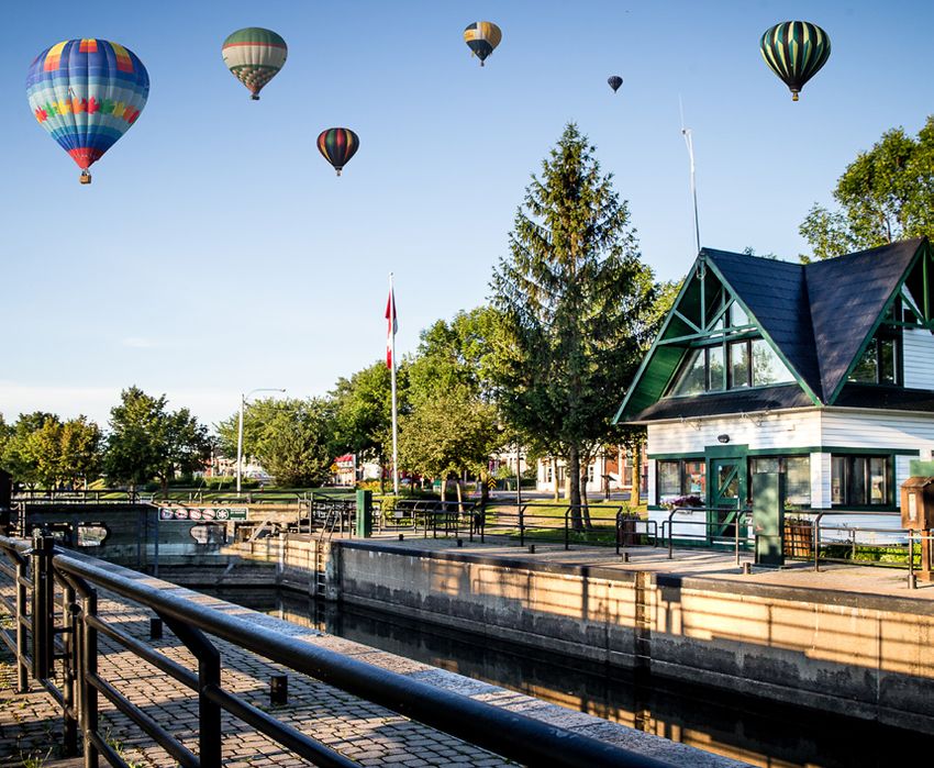
June 2018

Chambly Canal
National Historic Site of Canada

Management Plan
ii

© Her Majesty the Queen in Right of Canada, represented by
The Chief Executive Officer, Parks Canada Agency, 2018

Parks Canada
MANAGEMENT PLAN, CHAMBLY CANAL NATIONAL HISTORIC SITE OF CANADA, 2018

Paper:     R64-105/9-2018E
           978-0-660-24770-0

PDF:       R64-105/9-2018E-PDF
           978-0-660-24769-4

Cette publication est aussi disponible en français.

For more information on the management plan or on the
CHAMBLY CANAL NATIONAL HISTORIC SITE OF CANADA:

Chambly Canal National Historic Site of Canada:
1899, boul. de Périgny
Chambly, Quebec, J3L 4N3

Tel.: 450-658-0681 fax: 450-658-2428
E-mail: info.canal@pc.gc.ca
http://www.pc.gc.ca/en/lhn-nhs/qc/chambly

Sources of the images on the cover page
At the top, from left to right: Parks Canada and Library and Archives Canada, C-060786
Below: Parks Canada
Chambly Canal   iii
                                              Management Plan

Foreword

Canada’s national parks, national historic sites and national
marine conservation areas belong to all Canadians and offer
truly Canadian experiences.

These special places make up one of the finest and most
extensive systems of protected natural and cultural heritage
areas in the world.

The Government is committed to preserving our natural and
cultural heritage, expanding the system of protected places
and contributing to the recovery of species-at-risk. At the
same time, we must continue to offer new and innovative
visitor and outreach programs and activities so that more
Canadians can experience Parks Canada places and learn
about our environment, history and culture.

This new management plan for Chambly Canal National
Historic Site of Canada supports this vision.

Management plans are developed through extensive
consultation and input from various people and
organizations, including Indigenous Peoples, local and
regional residents, visitors and the dedicated team at Parks
Canada.

National parks, national historic sites and national marine
conservation areas are a priority for the Government of
Canada. I would like to thank everyone who contributed to
this plan for their commitment and spirit of co-operation.

As the Minister responsible for Parks Canada, I applaud this
collaborative effort and I am pleased to approve the Chambly
Canal National Historic Site of Canada Management Plan.

Catherine McKenna
Minister of Environment and Climate Change and
Minister responsible for Parks Canada
Chambly Canal v
Management Plan
RECOMMENDATIONS
Recommended by:
________________________________
Daniel Watson
Chief Executive Officer
Parks Canada
________________________________
Trevor Swerdfager
Senior Vice-President, Operations
Parks Canada
________________________________
Lauren Small
Director
Quebec Waterways Unit
Parks CanadaChambly Canal vii
Management Plan
Executive Summary
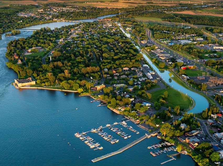
Located in the heart of the Montérégie area on the South shore of Montreal, the Chambly
Canal National Historic Site was designated to be of national historic significance in 1929.
Opened to navigation in 1843, this engineering infrastructure not only allowed
commercial barges to bypass the rapids of the Richelieu River, it also contributed
significantly to the development and the economic growth of adjacent municipalities.
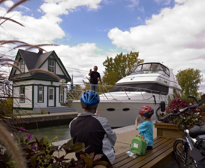
Today, the barges of the past have been replaced by pleasure boats, and the old towpath
has been converted into a multi-use path that attracts more than 250,000 visitors and
cyclists annually, making the Chambly Canal an important recreational tourism
destination. The diversity of the site's historic components, such as the locks, including
some that are still operated manually, as well as the archaeological remains of Fort-
Sainte-Thérèse, a distinct national historic site, contribute to the richness and the identity
of the Chambly Canal National Historic Site, one of the five (5) historic canals managed
by Parks Canada in Quebec.
Since 2015, significant investments have been made to improve the condition of the
infrastructure and buildings of the Chambly Canal and maintain its physical integrity.
These investments, representing approximately $50 million, are scheduled to continue
until 2020.
This Management plan replaces the 2007 plan and introduces the suggested vision for the
site for the next ten years. While a number of the 2007 plan’s objectives have been
accomplished, including identifying location of Fort-Sainte-Thérèse, others are in the
process of being achieved, such as the completion of significant rehabilitation work on the
canal infrastructure and the proposal of a management strategy for the non-functional
heritage bridges.
The vision for the Chambly Canal National Historic Site is to promote its heritage and
landscape, improve the visitor experience and increase the community’s sense of
ownership and pride in the site. The development of Fort-Sainte-Thérèse as a distinct
attraction along the Chambly Canal is also part of the proposed vision. Three (3) key
strategies support the vision for management of the site over the next 10 years:
Strategy 1: The Chambly Canal: a heritage, cultural and natural landscapes
and surroundings to preserve and enhance
The goal of this strategy is to protect and promote, for the benefit of current and future
generations, the built heritage, the surrounding environment and the cultural and natural
landscapes of the Chambly Canal. This strategy is intended to ensure that the condition of
the site’s historical components and the effort dedicated to their preservation reflect the
importance of this engineering work. Two objectives support this strategy:
Objective 1.1: The condition and integrity of the Canal's historic infrastructure
are improved;
Objective 1.2: The centres, sectors, cultural and natural landscapes of the
Chambly Canal are further recognized and showcased.viii
Strategy 2: An improved and diversified visitor experience from one end
of the canal to the other
This strategy is intended to improve the services and activities offered in order to enhance
the visitor and recreational boater experience along the Chambly Canal. The
improvement of visitor experience will be supported by the communities surrounding the
canal and will result in an enhanced distribution of services, experiences and activities, to
better meet the expectations of different clienteles and users. The objectives are the
following:
Objective 2.1: The service offer is better adapted to the needs of visitors and
pleasure boaters and better distributed according to the travel routes and
destination sites
Objective 2.2: New development plans, carried out in partnership with the
adjacent municipalities, contribute to improving the attractiveness of the
Chambly Canal
Objective 2.3: The renewal of programs and activities enhance visitor
experience.
Strategy 3: A source of pride and benefits for the community
Community pride in the Chambly Canal will contribute to its appreciation, while
increasing a sense of belonging and interest in contributing to the site. The
implementation of a strategy focused on partnerships, agreements and business
opportunities with partners will enhance the site’s performance in terms of visitor
experience, increase visitor loyalty and generate a positive impact on the surrounding
communities. The following objective supports this strategy:
Objective 3.1: The importance of the Chambly Canal is reflected in the level of
commitment and ownership of the site by the local community
The management plan suggests a targeted management approach for the Fort-Sainte-
Thérèse National Historic Site. The recent discovery of the location of the archaeological
remains of Fort-Sainte-Thérèse, on Fryer Island, requires the establishment of
management guidelines to ensure its conservation and development for years to come.
With the untapped potential of Fort-Sainte- Thérèse, the following objectives are put
forward:
• Recognize and promote the national historic value of the site
• Protect and enhance Fryer Island’s exceptional natural setting
• Make Fort-Sainte-Thérèse National Historic Site noticeable and accessible
along the course of the Chambly Canal
• Commemorate the history of the site through new interpretive activities.Chambly Canal ix
Management Plan
Table of Contents
Foreword ..............................................................................................iii
Recommendations................................................................................ v
Executive Summary .............................................................................vii
1.0 Introduction .................................................................................... 1
2.0 Significance of the Chambly Canal National Historic Site .............. 9
3.0 Planning Context ............................................................................ 9
4.0 Vision ............................................................................................ 10
5.0 Key Strategies .............................................................................. 11
6.0 Area management approach for the Fort-Sainte-Thérèse
National Historic Site .................................................................... 13
7.0 Summary of the Strategic Environmental Assessment ................. 18
Maps
Map 1: Regional Map ........................................................................... 2
Map 2: Chambly Canal National Historic Site....................................... 3
Map 3: Location map of the Fort-Sainte-Thérèse National
Historic Site ............................................................................. 16Chambly Canal 1
Management Plan
1.0 Introduction
Parks Canada manages one of the finest and most extensive systems of protected natural and historic
places in the world. The Agency’s mandate is to protect and present these places for the benefit and
enjoyment of current and future generations. Future-oriented, strategic management of each national
park, national marine conservation area, heritage canal and those national historic sites administered
by Parks Canada supports the Agency’s vision:
Canada’s treasured natural and historic places will be a living legacy, connecting hearts and minds
to a stronger, deeper understanding of the very essence of Canada.
The Parks Canada Agency Act requires Parks Canada to prepare a management plan for national
historic sites administered by the Agency. The Management Plan for the Chambly Canal National
Historic Site of Canada, once approved by the Minister responsible for Parks Canada and tabled in
Parliament, ensures Parks Canada’s accountability to Canadians, outlining how historic site
management will achieve measurable results in support of the Agency’s mandate.
Canadians, partners in the community as well as different stakeholders were involved in the
preparation of the new management plan, helping to shape the future direction of the national
historic site. The plan sets clear, strategic direction for the management and operation of Chambly
Canal National Historic Site by articulating a vision, key strategies and objectives. Parks Canada will
report annually on progress toward achieving the plan objectives and will review the plan every ten
years or sooner if required.
This plan is not an end in and of itself. Parks Canada will maintain an open dialogue on the
implementation of the management plan, to ensure that it remains relevant and meaningful. The
plan will serve as the focus for ongoing engagement on the management of the Chambly Canal
National Historic Site in years to come.
This management plan also includes the Fort-Sainte-Thérèse National Historic Site, located on Fryer
Island, within the limits of the Chambly Canal National Historic Site. Considering its historical
importance and distinct context for its designation, Fort-Sainte-Thérèse is subject to an area
management approach, where particular objectives and targets are proposed.SAINT- O URS
40
Saint-Ours Canal
15
QUÉ BE C
L AVA L 25
20
Carillon Canal
M O N TR É A L
15
30
40
Lachine Canal
ONTARIO Chambly Canal
Sainte-Anne-de-Bellevue Canal CHA M B LY
10
E ST RIE
VA UDR EUIL - DO R IO N
ÎL E- P ER R O T
LO NG UE UIL
20 30
( U N I TE D STATE S) S A I NT-J E A N-
15 S U R -R I CHE LI E U
REGIONAL CONTEXT MAP 1
REGION QUÉBEC WATERWAYS PARKS CANADA’S HISTORIC CANALS (QUÉBEC) 0 5 10 20km JULY 2017Fryer Sainte-Marie
Island Island
Sainte-Thérèse Old Saint-Jean
Island
Chambly Old Chambly
Basin Richelieu
10
Saint-Jean-sur-Richelieu Saint-Jean-sur-Richelieu
Carignan
35
Richelieu
Richelieu River
Chambly
Carignan
Saint-Jean-sur-Richelieu
MAP 2.2 Saint-Jean-sur-Richelieu
MAP 2.4
Chambly MAP 2.3
FRYER ISLAND / FORT SAINTE-THÉRÈSE
MAP 2.1 NATIONAL HISTORIC SITE MANAGEMENT AREA
PARKS CANADA
MANAGEMENT PLAN MAP 2
PARK AND GREEN SPACE 0 1 2 4km JULY 2017Chemin
B
223
112
Carignan
Bridge 4
se Old Power Station (remains)
Yule
érè
te -Th
Brid
Sain
min Bridge 3
ge
Che
Richelieu
Richelieu
River Lock no 8
Old CN Railway Bridge
Lock no 7
Des
e
Ru
Rapides
1 re
l
ana
Park
du C
min
Bridge 2 (Non-operational)
Che
e
ogn
Robert-Lebel
urg
Park
Bo
ue
n
Ave
Lock no 6
elieu
Chambly De la
Rue de Rich
Rapids Commune
Park
Chambly Lock no 5
Islands
Bouleva
rd Indu
striel
Lock n 4 o
112 Chambly
rigny
De Pé
vard
Canal
Boule
Workshop
Fort Chambly
National Historic Site
Chambly
ult
Des
nea
Basin Ateliers
Mig
Park
Rue
Locks no 1-2-3
Chambly
Marina
tty Bridge 1
ly Je
eabm
o wCnhsatrm
D
Superintendent’s
House
Boulev
ard Fré
chette MANAGEMENT PLAN MAP 2.1
PARKS CANADA EDESTRIAN & BICYCLE PATH /
P 2.1 2.2 2.3 2.4
HISTORIC TOWPATH
CARIGNAN
CITY CHAMBLY PARK AND GREEN SPACE OLD CHAMBLY SECTOR 0 250 500 1 000 m JULY 2017 CHAMBLY SAINT-JEAN-SUR-RICHELIEUMichel-C
Richelieu
hartrand
Richelieu
ridge B
Sainte-Th
érèse 223 River
Chemin
133
Chemin du Canal
Chemin des Patriotes
Bridge 5
10 Bridge 7
Fryer Island / Fort Sainte-Thérèse
National Historic Site Management Area
FryFe
Fryer
rryeRr
idge 4 Chambly Carignan Rapids
e
gDualm
-Marie Sainte-Marie
ator
Sainte Island
d e l’Île-
ion (remains) Ru e
Fryer
Che
Island
min
Sai Bridge 9
nte
-Th
érè
se Old Bridge 9 (Non-operational)
Dam Keeper’s
House (remains)
Saint-Jean-
Fort Sainte-Thérèse Fort Sainte-Thérèse Carignan sur-Richelieu
National Historic Site (remains)
Bunker Hill Fort Sainte-Thérèse
Cemetery National Historic Site
Chemin de la Grande-Ligne
Commemorative Plaque
MANAGEMENT PLAN MAP 2.2
PARKS CANADA 2.1 2.2 2.3 2.4
CARIGNAN
CHAMBLY EDESTRIAN & BICYCLE PATH /
P
CITY SAINT-JEAN-SUR-RICHELIEU PARK AND GREEN SPACE HISTORIC TOWPATH 0 250 500 1 000 m JULY 2017 CHAMBLY SAINT-JEAN-SUR-RICHELIEU133
Saint-Jean-sur-Richelieu
Richelieu
River
Che
min
des
Pat
riot
es
-Marie Sainte-Marie
Sainte Island
d e l’Île-
Ru e
Sainte-Thérèse Island
Bridge 9 Les Mille
Ru
eB
Rue Roches
Old Bridge 9 (Non-operational) Jean
ail
-Talo Rapids
lar
n
ge
on
Saint-Jean-
ort Sainte-Thérèse Carignan sur-Richelieu Old Bridge 10 (Non-operational)
emains)
Lys
de-
ur-
Chemin de la Grande-Ligne
Fle
e la
Chemin Sainte-Thérèse
ed
plain
Ru
Bridge 10 Cham
Rue
Pavillon-de-
la-jeunesse
223 Park Boul. du Séminaire N
Rue Chênevert
s
s Colibri
Iroquois
Boul. Saint-Luc
Creek
Rue de
Boul. de Normandie
MANAGEMENT PLAN MAP 2.3
PARKS CANADA 2.1 2.2 2.3 2.4
CARIGNAN EDESTRIAN & BICYCLE PATH /
P
CITY SAINT-JEAN-SUR-RICHELIEU PARK AND GREEN SPACE HISTORIC TOWPATH 0 250 500 1 000 m JULY 2017 CHAMBLY SAINT-JEAN-SUR-RICHELIEUe
2e Ru
10 A
2e Avenue
e ven
5e Av
ue
enu
Rue Bellerive
e
15e Avenue
Gouin Bridge
Saint-Jean-sur-Richelieu Rue
CMQR
re
1
y
Railwa
Alcide-Marcoux anJJeetttty
strt-eJaem
Park SUapin
y
Saint-Jean-sur-Richelieu
Bridge
tes Marina
Patrio
in des Saint-Jean Rue du Q
uai
Chem
Rapids Rue Richelieu
133
Place du quai Rue Champlain
in Rue Ja
Cha
mpla Lock no 9 cques
-Cartie
Rue r
Rue Saint-Jacques
Rue Saint-Charles
Boul. Saint-Joseph
Rue Frontenac
Rue Saint-Paul
Rue Foch
Des Moulins Rue Mercier
Félix-Gabriel-Marchand Bridge
Richelieu Langelier Area
River
Les Mille
Roches
Rapids
Christophe-
Colomb
Park Saint-Jean-sur-Richelieu
perational)
223
35
Rue MacDonald
plain Domaine-de-Beauchamp
Cham Park
Rue
Boul. du Séminaire N
Rue Dorchester
Boul. Saint-Luc
Rue Pierre-Caisse
Boul. de Normandie
MANAGEMENT PLAN MAP 2.4
PARKS CANADA EDESTRIAN & BICYCLE PATH /
P 2.1 2.2 2.3 2.4
HISTORIC TOWPATH
CITY SAINT-JEAN-SUR-RICHELIEU PARK AND GREEN SPACE OLD SAINT-JEAN SECTOR 0 250 500 1 000 m JULY 2017 CHAMBLY SAINT-JEAN-SUR-RICHELIEUChambly Canal 9
Management Plan
2.0 Significance of the Chambly Canal National Historic Site
The Chambly Canal is a national historic site located in the heart of the Montérégie region, connecting
the towns of Chambly and Saint-Jean-sur-Richelieu and passing through the towns of Carignan and
Richelieu. The site consists of a waterway of approximately twenty kilometres in length, with nine
locks that allow boats to bypass the Richelieu River rapids, while passing through a change in
elevation of twenty-four metres (24 m). The towpath, formerly used by horses hauling commercial
barges along the canal, is today a multi-use path that is greatly enjoyed by cyclists and pedestrians.
The canal path is also part of the national and local cycle network, including the Canadian Great Trail
and Quebec’s Route Verte.
The Chambly Canal was designated a site of national historic significance in 1929 for its role in the
Canadian network of canals, namely in the navigation and trade network of the Richelieu-Champlain-
Hudson corridor. The canal also contributed to the economic growth of the town of Chambly and
specifically to that of Saint-Jean-sur-Richelieu, which was a hub of marine, road and rail transport in
the 19th century.
Some historical components of the canal and its landscape, still present today, testify to the canal’s
commercial use in the 19th and 20th centuries, as well as the evolution of the engineering materials
and techniques associated with its construction and maintenance. The Chambly Canal still operates
certain locks manually, as in the past. The site also consists of a diversity of cultural resources that
contribute to its identity, including: the downstream and upstream jetties, the Superintendent's
House in Chambly, the historic lock station cabins, the Woodworking Shop, the bridges (functional
and non-functional) and the archaeological remains of Fort-Sainte-Thérèse.
The canal holds an important place among the recreational and tourist destinations of the Montérégie
area. In 2016, 260,000 people and 1,500 recreational vessels visited the site. Crossing through urban
and agricultural landscapes, the diversity of the cultural and natural environments of the canal
contributes to its identity and enhances the visitor experience. Interestingly, the Fort-Sainte-Thérèse
National Historic Site, on Fryer Island, is located within the boundaries of the Chambly Canal
National Historic Site. Designated as a site of national historic significance in 1923 by the Historic
Sites and Monuments Board of Canada (HSMBC) for its role in the supply network and the defence
infrastructure of Canada during the French colonial era, it was only in 2008-2009, during
archaeological excavations, that the exact location of Fort-Sainte-Thérèse was discovered.
3.0 Planning Context
This document replaces the 2007 Chambly Canal National Historic Site Management Plan, which
suggested a variety of strategies to achieve goals related to the conservation and enhancement of the
landscape, the cultural and natural resources, transmission of commemorative integrity messages and
heritage values, number of visits, facilities, partnerships and revenue generation. While some of the
strategies identified in the plan were implemented, including finding the location of the Fort-Sainte-
Thérèse National Historic Site, others are in the process of being implemented, such as the significant
rehabilitation work on buildings and engineering structures and the establishment of a management
strategy for the non-functional heritage bridges.
As a site open to surrounding communities, the Chambly Canal’s situation sets it apart from other
national historic sites of the Parks Canada network. Crossing the boundaries of municipalities with
distinct characteristics and development visions, the management and maintenance of the canal’s
integrity present a challenge.10 In recent years, the clientele visiting the Chambly Canal has changed. Today, while boaters are older, they are stable in number, whereas the visitor clientele on the banks is more diversified. In addition, visitor and boater expectations are higher, particularly with respect to the provision of services: they now seek Wi-Fi access, overnight mooring with services, light food service options and art facilities. The recent discovery of Fort-Sainte-Thérèse on Fryer Island requires the establishment of management guidelines for the coming years, to ensure its conservation and enhancement. It is important to mention that, through its involvement in the guardianship of the fort’s remains in recent years, the local community has shown a great sense of belonging associated with this site. Since 2015, significant investments have been made to improve the condition of the Chambly Canal’s infrastructure and buildings and maintain its physical integrity. These investments, representing approximately $50 million, are scheduled to continue until 2020. Parks Canada will ensure that the canal’s infrastructure meets the requirements for public safety (management of water and dams) and will work with the relevant authorities to plan emergency measures. The continuing transformation of the Chambly Canal environment is leading Parks Canada to consider the means and strategies that will encourage a collaborative management approach for the historic site. The 10-year Management Plan review process represents an opportunity to address these priorities and strengthen the participation of the local community and stakeholders. 4.0 Vision The vision below expresses the desired state for the Chambly Canal National Historic Site for the coming years, from now to 2030. The waterways managed by Parks Canada were once vital links for transportation and economic activity in Canada. Today, they continue to perpetuate this tradition in many Canadian communities by contributing to their socio-economic development. Parks Canada will work in partnership with others to transform the canals, both the water and the land, into world-class sites, vibrant and animated, fostering recreation, tourism and economic development, while preserving the natural, historic and cultural environment for future generations. As a must-see recreational, tourist and heritage destination of the greater Montreal area, the Chambly Canal National Historic Site’s reputation is well established. In harmony with adjacent communities, the Chambly Canal receives large numbers of visitors and boaters. Through its diversity of services and signature activities, the Chambly Canal stands out and offers a multitude of experiences throughout the year. The Chambly Canal’s identity stands apart because of its diverse landscapes and its still-present historic features. Pedestrians, cyclists and boaters, delighted with the quality of the facilities and amenities offered, are encouraged to extend their visits and to return. The canal’s engineering structures are attentively showcased and promote the national historic significance of the Chambly Canal within the Richelieu River region and of Canada’s Historic Canals network. Because of the accessibility and the development of the site, the Fort-Sainte-Thérèse National Historic Site is a distinct attraction along the route of the Chambly Canal. Benefiting from amenities and activities that respect and enhance the exceptional natural setting of Fryer Island, the history of Fort-Sainte-Thérèse is recognized and appreciated by visitors. As a welcoming destination for visitors, the Chambly Canal is an established feature of the region, as well as a lever of socio-economic development for local communities. The active participation of businesses, organizations, partners and volunteers makes it possible to offer diversified and quality programs and services. The appreciation and ownership of, and pride in the Chambly Canal National Historic Site reflect its significant place in the community.
Chambly Canal 11
Management Plan
5.0 Key Strategies
The suggested approach for the implementation of the vision for the Chambly Canal National Historic
Site over the coming years is based on the following priorities: to preserve and enhance the heritage,
cultural and natural environments and landscape of the canal; to promote an improved and
diversified visitor experience throughout the canal; and finally, to be a source of pride and benefits for
the community.
The three key strategies outlined below will guide the management of the site over the next ten years.
Specific objectives and targets are associated with each key strategy in order to measure progress on
their achievement over the coming years.
Key strategy No. 1
The Chambly Canal: a heritage, cultural and natural landscapes and surroundings
to preserve and enhance
The goal of this strategy is to protect and promote, for the benefit of present and future
generations, the built heritage, surroundings and cultural and natural landscapes of the Chambly
Canal. This strategy is intended to ensure that the condition of its historical elements as well as the
efforts dedicated to their preservation reflect the importance of this engineering work. The
implementation of distinctive development plans will promote the characteristic features of the
canal and will contribute to the prestige of the Chambly Canal National Historic Site and that of
the Parks Canada network.
Objective 1.1: The condition and integrity of the canal’s historic infrastructure
are improved
Targets:
- By 2028, the condition of infrastructure assessed to be "poor" or "fair" (2017) is
improved.
- The level of visitor satisfaction with the condition of available facilities has
increased by 10 % by 2028.
Objective 1.2: The poles, sectors, cultural and natural landscapes of the
Chambly Canal are further recognized and showcased
Targets:
- By 2021, the main poles and sectors of the canal are defined and are subject to a
development plan that highlights the cultural and natural setting as a place for
recreation, relaxation and recreational boating.
- The cultural landscape of the canal is identified and developed for interpretive
purposes by 2022.
- By 2028, at least three (3) of the canal’s historical works (locks, Superintendent's
House, historical lock station cabins, the Woodworking Shop, some non-functional
bridges, etc.) are improved and showcased.12
Key strategy No. 2
An improved and diversified visitor experience from one end of the canal to the other
This strategy is intended to improve the services and activities offered in order to enhance the visitor
and recreational boater experience along the Chambly Canal. Improving the visitor experience will be
supported by the communities surrounding the canal and will aim at a better distribution of services,
experiences and activities offered, so as to better meet the expectations of different clienteles and
users.
Objective 2.1: The service offer is better adapted to the needs of visitors and
pleasure boaters and better distributed according to the travel routes and
destination sites
Targets:
- In collaboration with adjacent municipalities, a concept of rest areas and
destination sites, integrating the main urban centres, is developed throughout the
canal by 2022.
- By 2023, the main rest areas along the canal’s route are provided with basic
services (toilets, water fountains, picnic areas, etc.).
- The overnight mooring sites in Chambly and Saint-Jean-sur-Richelieu offer
electricity services by 2022.
- The level of visitor satisfaction with the overall quality of services has increased by
10 % by 2028.
Objective 2.2: New development plans, carried out in partnership with the
adjacent municipalities, contribute to improving the prestige of the Chambly
Canal
Targets:
- By 2022, the downstream jetty located in Chambly is rehabilitated and reopened
to the public.
- With the participation of adjacent municipalities, pedestrian and cyclist access
points to the site are improved by 2024, according to the planning principles and
parameters for the Chambly Canal.
- The number of visitors on the banks increases 2% annually, while the number of
boats moored increases by 10 % by 2028.
Objective 2.3: The renewal of programs and activities enhance visitor experience
Targets:
- In partnership with the municipalities and the local community, at least one (1)
annual signature event is established by 2026.
- New themed trails or “loops” (cycling, pedestrian, and water) in the surrounding
municipalities are created in collaboration with the community.
- A new interpretive program to renew and update heritage presentation tools and
activities is developed by 2024.
- The number of visitors and recreational boaters who consider that they have
learned about the cultural heritage of the national historic site has risen by 5 % by
2028.Chambly Canal 13
Management Plan
Key strategy No. 3
A source of pride and benefits for the community
The pride of the community in the Chambly Canal will contribute to its appreciation, while
increasing a sense of belonging and interest in contributing to the site. The implementation of a
strategy focused on partnerships, agreements and business opportunities in collaboration with the
community will enhance the site’s performance in the visitor experience, increase visitor loyalty and
generate a positive impact on the surrounding communities.
Objective 3.1: The importance of the Chambly Canal is reflected in the level of
commitment and ownership of the site by the local community
Targets:
- A strategy to support community initiatives along the Chambly Canal is
identified by 2025.
- By 2028, at least five (5) new agreements with event promoters, businesses,
organizations, partners, volunteers and the community will result in new
services to visitors and recreational boaters.
- The number of visitors who consider the Chambly Canal National Historic Site
to be important to them increases by 15 % by 2028.
- By 2021, an advisory committee is established in collaboration with the
community (municipalities, local organizations, tourism organizations,
Regional County Municipalities, etc.), in order to support Parks Canada in its
role of protection, promotion and animation of the site.
6.0 Area management approach for the Fort-Sainte-Thérèse National
Historic Site
An area management approach is intended to express a specific focus to a well-defined sector that
presents unique management issues, opportunities and challenges. Fort-Sainte-Thérèse was
designated as a National Historic Site in 1923 for the following reasons:
- the fort was built in 1665 by the Carignan-Salières regiment during the Iroquois wars;
- the fort’s role in the supply network made it an essential component of Canada’s defence
infrastructure during the French colonial era.
As part of the planning exercise for the Chambly Canal National Historic Site, the area management
approach is ideal for the Fort-Sainte-Thérèse National Historic Site due to:
- the location of Fort-Sainte-Thérèse on Fryer Island, within the limits of the Chambly Canal
National Historic Site;
- the exceptional natural setting of Fryer Island, where a diversity of fauna and flora can be
found, offering a unique natural environment along the canal;
- during recent archaeological excavations, the discovery of the exact location of the fort that
was designated a national historic site in 1923;
- the potential offered by the Fort-Sainte-Thérèse site, given its historical purpose and its
strategic position along the Richelieu River, initially as the main axis of navigation for the
Indigenous Peoples along the St. Lawrence River, and then as a strategic area in the14
development of relationships between the Indigenous communities and the French Crown
until 1670;
- the sense of belonging shown by the local community for Fort-Sainte-Thérèse since its
discovery, particularly through investment in the development and promotion of the site;
- the opportunity represented by the proximity of the Chambly Canal National Historic Site and
Fort-Sainte-Thérèse National Historic Site to enrich and diversify the visitor experience.
Taken as a whole, these elements confer a special status to the Fort-Sainte-Thérèse for its recognition,
the promotion of its history and its improvement. The Fort-Sainte-Thérèse National Historic Site can
aspire to become a distinct and accessible hub along the route of the Chambly Canal, as well as a
unique attraction for citizens and visitors. The strategy to achieve this requires the collaboration of
local partners and organizations as well as a concerted vision of development.
The specific objectives for the management of the Fort-Sainte-Thérèse National Historic Site over the
next ten years are presented below. Each objective has targets that will measure progress toward these
goals over the coming years.
Objective 1.1: The national historic value of Fort-Sainte-Thérèse is recognized and
showcased
Targets:
- The commemorative integrity statement for the Fort-Sainte-Thérèse National Historic
Site is completed by 2020.
- By 2020, discussions have begun with the Historic Sites and Monuments Board of
Canada (HSMBC) to review the designation text and the location of the
commemorative plaque of the Fort-Sainte-Thérèse National Historic Site.
- Archaeological work on Fort-Sainte-Thérèse continues, by 2024, to validate the
presence of the south curtain wall (terrestrial archaeology) and the eastern front
(underwater archaeology) of the fort. This will take place in partnership with the local
communities and the Indigenous communities of the Montreal area.
- A master plan for the development and improvement of the Fort-Sainte-Thérèse
National Historic Site and Fryer Island is completed by 2026.
Objective 1.2: The exceptional natural environment of Fryer Island is protected
and enhanced
Targets:
- By 2023, the different sectors of Fryer Island are inventoried for protection and
enhancement purposes.
- In collaboration with the community, a discovery trail highlights the different sectors of
Fryer Island by 2027.
Objective 1.3: The Fort-Sainte-Thérèse National Historic Site is a distinct and
accessible point of interest along the course of the Chambly Canal
Targets:
- By 2027, a site promotion strategy for providing services and activities is established.
- By 2028, visitors will be able to recognize the Fort-Sainte-Thérèse site.
- In collaboration with the organizations, volunteers, local and business communities, a
strategy to promote access to the historic site is identified by 2025.Chambly Canal 15
Management Plan
Objective 1.4: New interpretive activities commemorate the history of Fort-
Sainte-Thérèse
Targets:
- By 2027, an interpretive program of the history of Fort-Sainte-Thérèse and the
Richelieu River is developed, in partnership with local communities and the Indigenous
communities in the Montreal area.
- Fort-Sainte-Thérèse’s interpretive activities and tools are implemented with partners
by 2028.
The following page shows the boundaries of the Fort-Sainte-Thérèse National Historic Site for the
purposes of the proposed area management approach.es
iot
FrFyre
yr
erRD
e
gaumla
Richelieu
River
tor in te-Ma
rie
Île-Sa
de l’
Rue
Sainte-Marie
Island
Fryer Island
Fort Sainte-Thérèse Fort Sainte-Thérèse
National Historic Site (remains)
Chemin Sainte-Thérèse
Rue René-Dumas
Fort Sainte-Thérèse Dam Keeper’s
National Historic Site House (remains)
Commemorative Plaque Carignan
MANAGEMENT PLAN MAP 3
FRYER ISLAND /
EDESTRIAN & BICYCLE PATH /
P FORT SAINTE-THÉRÈSE NATIONAL
CITY CARIGNAN PARKS CANADA HISTORIC TOWPATH 0 50 100 200m JULY 2017 HISTORIC SITE MANAGEMENT AREA18 7.0 Summary of the Strategic Environmental Assessment In accordance with the Cabinet Directive on the Environmental Assessment of Policy, Plan and Program Proposals (2010), a strategic environmental assessment (SEA) was conducted on the Management Plan proposal for the Chambly Canal Historic Site, which also includes the Fort-Sainte- Thérèse National Historic Site located on Fryer Island within the boundaries of the Chambly Canal. The strategic environmental assessment is intended to integrate environmental concerns into the development of program policies, plans and proposals in order to support environmentally sound decision-making. Individual projects undertaken to implement the objectives of the Management Plan objectives of the Chambly Canal National Historic Site will be evaluated separately to determine if an impact assessment is required under the Canadian Environmental Assessment Act (2012), or successor legislation. The scope of the assessment included the area within the boundaries of the historical site and the administered site and covered a ten-year period. In addition to the cultural resources, the environmental components worthy of mention at this site include the aquatic wildlife and its habitat as well as the shoreline and surrounding area flora of the Fort-Sainte-Thérèse National Historic Site. Many residual positive effects will occur as a result of the implementation of the plan. The biggest positive effects of this plan will be the improvement in the offers of services, activities, programs, shelters or courses in order to enhance the experience of visitors and recreational boaters. The increase in the number of visits will improve the understanding, awareness, support and appreciation of the natural and cultural resources by the public. Some strategies, initiatives and targets identified in the management plan are likely to result in adverse environmental effects. These include the maintenance of cultural resources, marine structures and the draft depth of a navigable waterway on the one hand, and, on the other, the creation of a new service offering. The SEA has helped to identify possible environmental effects on the shoreline, water bodies and aquatic wildlife. The effects can be reduced by complying with measures to avoid serious harm to fish and by avoiding the most vulnerable periods and sites. The coaching and acquisition of knowledge from the organizations or any other interested partners in providing services on Fryer Island can also help to limit the impact. Other potential environmental effects can be mitigated by following existing guidelines and conducting impact assessments for projects. These assessments will identify the effects on the valued components and will contribute to mitigating the potential negative effects on cultural and natural resources, the visitor experience and relations with different partners. Public participation was solicited for this management plan, which included a summary of the draft of the present SEA (November-December 2017). The concerns raised by the public were integrated into the plan. This plan supports the objective of the Federal Sustainable Development Strategy, which consists of “Connecting Canadians with Nature”. We can assume that other measures will be considered during the development of the project or current operations. There are no significant adverse environmental effects anticipated from implementation of the management plan.
You can also read