British Columbia Geological Survey annual program review 2021-2022
←
→
Page content transcription
If your browser does not render page correctly, please read the page content below
British Columbia Geological Survey annual program
     review 2021-2022

     Neil Wildgust1, a, Yao Cui1, Gordon Clarke2, and Adrian S. Hickin1
     1
       British Columbia Geological Survey, Ministry of Energy, Mines and Low Carbon Innovation, Victoria, BC, V8W 9N3
     2
       British Columbia Geological Survey, Ministry of Energy, Mines and Low Carbon Innovation, Vancouver, BC, V6Z 2G3
     a
       corresponding author: Neil.Wildgust@gov.bc.ca

     Recommended citation: Wildgust, N., Cui, Y., Clarke, G., and Hickin, A.S., 2022. British Columbia Geological Survey annual program review
     2021-2022. In: Geological Fieldwork 2021, Ministry of Energy, Mines and Low Carbon Innovation, British Columbia Geological Survey
     Paper 2022-01, pp. 1-15.

     Executive Summary
        This paper provides an overview of current British Columbia Geological Survey (BCGS) applied geoscience activities and highlights key
     findings from 2021 projects. Headquartered in Victoria, the Survey is part of the Mines, Competitiveness and Authorizations Division in the
     British Columbia Ministry of Energy, Mines and Low Carbon Innovation. The Survey generates geoscience knowledge and data to inform land
     use and resource management decisions, and to support the growth of British Columbia as a competitive jurisdiction for mineral exploration.
        The Cordilleran Geoscience Section of the Survey conducts field and office research, including bedrock and surficial geology mapping
     programs, regional geochemical surveys, and targeted mineral deposit studies. The past year saw further progress of multi-year mapping and
     applied research across the province, boosted by the return of fieldwork from July through to late September as pandemic-related restrictions
     eased. Highlights included mapping in the Kitsault area in the northwest and the Kaslo Lake-Lardeau area in the south, and the deployment
     of remotely piloted aircraft systems (RPAS) to gather geophysical data in the central part of the province. Critical minerals, an emerging topic
     of importance in the context of material requirements for low-carbon technologies, provided the focus for a three-day online workshop hosted
     by the Survey in collaboration with the Geological Survey of Canada, the United States Geological Survey, and Geoscience Australia. The
     workshop attracted more than 700 participants from the geoscience community across the world and demonstrated the importance of minerals
     system research in evaluating critical mineral resources.
        Responsible for maintaining and developing provincial geoscience databases, the Resource Information Section disseminates data online
     through MapPlace. Information managed by the team includes traditional geological maps together with thematic studies and reports,
     geochemical, geophysical, and geological databases, plus information such as MINFILE, COALFILE, Mineral Assessment Reports (ARIS), and
     Property File. These databases also support development of next-generation mineral potential assessments using machine learning, which is now
     a major focus for the Survey to support land use and resource planning initiatives.
        The Mineral Development Office (MDO) provides investment intelligence to government and global business, publishing the annual Provincial
     Overview of Exploration and Mining in British Columbia volume, and includes three Regional Geologists who track minerals activity across
     the province.

     1. Introduction                                                            In the northeast part of the province, the Western Canadian
       This paper provides an overview of current British Columbia              Sedimentary basin hosts significant petroleum hydrocarbon
     Geological Survey (BCGS) applied geoscience activities and                 resources.
     highlights key findings from 2021 projects. Headquartered in                 The Survey is the primary repository for provincial
     Victoria, the Survey is part of the Mines, Competitiveness and             geoscience knowledge. Maps, reports, and databases are freely
     Authorizations Division in the British Columbia Ministry of                available online to inform First Nations and stakeholder groups
     Energy, Mines and Low Carbon Innovation. As the steward of                 including local communities, the minerals industry, public safety
     geoscience and mineral resource information in the province,               agencies, environmental scientists, research organizations,
     the Survey has an important role in stimulating activity,                  and government agencies. Active Survey research programs
     attracting investment, informing decisions through technical               (Fig. 1) continue to define the geological evolution and natural
     information, and providing continuous research based on more               resources of the province, generating knowledge and data
     than a century of corporate memory.                                        to support land use and resource management decisions that
       The province is endowed with significant natural resources               balance economic, environmental, and community interests.
     including metallurgical coal, base and precious metals, and                A particular focus is providing public geoscience to support
     industrial minerals. These deposits are intimately tied to the             the growth of British Columbia as a competitive jurisdiction
     tectonic evolution of the Canadian Cordillera, which continued             for mineral exploration. Not only does this include supporting
     from protracted supercontinent breakup starting about                      industry, but also providing mineral resource information that
     1600 million years ago to accretionary processes that operate              is essential for informed land use decisions by government
     today as Pacific Ocean crust slides beneath Vancouver Island.              and, increasingly, from communities. Linked to the provision

                                                                            1
Geological Fieldwork 2021, British Columbia Ministry of Energy, Mines and Low Carbon Innovation, British Columbia Geological Survey Paper 2022-01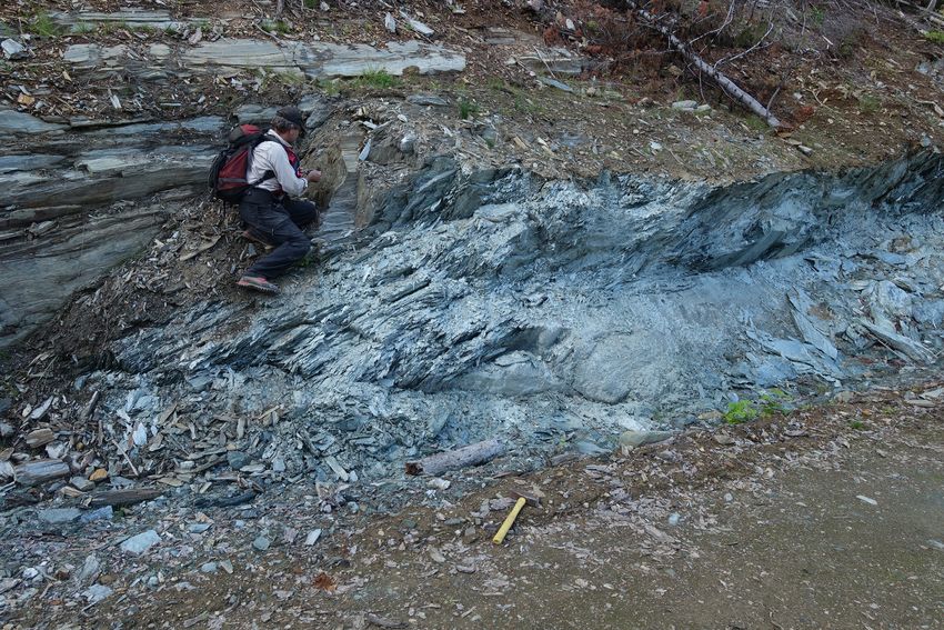
Wildgust, Cui, Clarke, and Hickin

                                                                                 Besa River
                                                                                 Group
                                   Dease Lake,
                                   regional
                                                       Iskut,
                                                       regional
                                                       Lay Range                        Glacial
                                                                          Polaris
                                                       assemblage                       transition

                                                           Hogem batholith
                                     Kitsault,                                      Gething
                                     regional                                       Formation

                                                              Depth-to-bedrock

                                                                         Woodjam and
                                                                         Mt. Polley RPAS
                                                                         (drone)
                                                                                                      Central Nicola arc,
                                                                                                      regional

                                                                       Salmon River geochronology
                                                                                                               Lardeau Group
                                                                                    Kamloops Group

                                                                                       Tulameen intrusion

                                                                                      Atmospheric mercury

     Fig. 1. British Columbia Geological Survey projects in 2021.

     of geoscience information, the transformation of historic               contract employment and training of geoscience assistants,
     geoscience information to digital formats and databases                 typically undergraduate and graduate students. The Resource
     requires coordinated effort as an ongoing, multi-year initiative.       Information Section is responsible for maintaining and
        The Survey is staffed by 35 employees, although several              developing provincial geoscience databases and disseminating
     positions are vacant and are currently in the process of being          data online through MapPlace, the BCGS geospatial web
     filled. The BCGS consists of three sections: 1) Cordilleran             service. The Resource Information Section is also responsible
     Geoscience; 2) Resource Information and 3) the Mineral                  for collecting, evaluating, approving, and archiving mineral
     Development Office (based in a Vancouver satellite office and           and coal exploration assessment reports submitted by industry
     with Regional Geologists across the province). The Cordilleran          to maintain titles in good standing. The Mineral Development
     Geoscience Section generates new knowledge through field-               Office (MDO) provides investment intelligence to government
     and desk-based research activities including bedrock and                and global business, publishing the annual Provincial Overview
     surficial geology mapping programs, regional geochemical                of Exploration and Mining in British Columbia volume (e.g.,
     surveys, and targeted mineral deposit studies. Section team             Clarke et al., 2022), and includes three Regional Geologists
     members manage in-house laboratory facilities, curate                   who track minerals activity across the province (two positions
     the provincial sample archive, and build capacity through               are currently vacant).

                                                                         2
Geological Fieldwork 2021, British Columbia Ministry of Energy, Mines and Low Carbon Innovation, British Columbia Geological Survey Paper 2022-01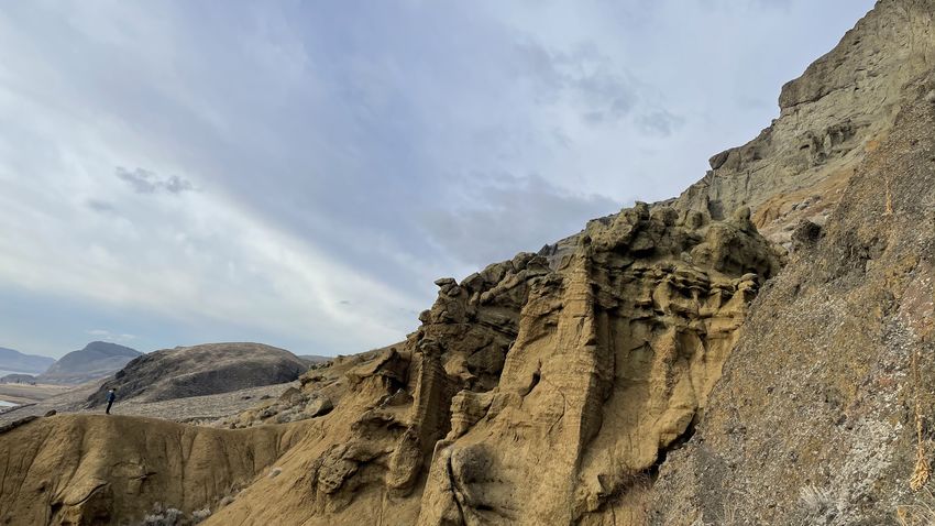
Wildgust, Cui, Clarke, and Hickin

       The Survey welcomed Nate Corcoran as Regional Geologist                  The Survey signed an agreement with Newcrest Mining
     for the Northeast and North Central regions in 2021. However,            Limited in 2021 to facilitate extensive lithogeochemical
     the Survey endured a challenging year with several retirements           analyses of 1000 igneous rock samples collected in
     and resignations. Larry Jones retired as Director of the                 northwestern BC and stored in the BCGS archive facility.
     Resource Information team in August, with Yao Cui covering               Under the terms of the agreement, analyses will be undertaken
     this position on an acting basis for the remainder of the year. In       using both total (fusion) and ‘4-acid’ digestion coupled with
     addition, the Cordilleran Section lost Graham Nixon and Janet            ICP-ES and ICP-MS techniques. The resulting dataset will be
     Riddell to retirement. Larry, Graham, and Janet will be much             published by BCGS in 2022. This project underscores the value
     missed by their colleagues and we wish them happy retirements            added to geoscience in the province by the archive facility and
     after decades of service, although Graham remains connected              may provide a blueprint for future collaborative research and
     with Emeritus status. The year also saw Deanna Miller,                   public-private partnerships using archived samples.
     Sarah Meredith-Jones, and Sean Tombe leave the Survey for
     fresh opportunities. Jenny Boulet left for maternity leave in            3. Cordilleran Geoscience Section
     September and was temporarily replaced by Lisa Giesbrecht.                 Section geologists collect fundamental geoscience
     The Survey anticipates a busy year for recruitment in 2022 as            data through single- and multi-year field-based programs
     various competitions are launched to fill these vacancies.               complemented by laboratory and office studies, including
       The global Covid-19 pandemic again affected Survey                     regional-scale mapping, mineral deposit studies, and
     operations in 2021; staff continued to work from home for much           development of new mineral exploration methods. Expertise
     of the year. The gradual relaxation of public health restrictions        encompasses tectonics, structural geology, stratigraphy,
     in the spring and early summer allowed relatively late planning          petrology, metallogeny, coal deposits, Quaternary and surficial
     and execution of some field programs between mid July and                geology, critical minerals, and geochemistry.
     late September. External laboratory services continued to be               Engagement with First Nations communities is a priority for
     affected in many cases, leading to delays in analytical testing          the Survey. As summer field projects are planned, liaising with
     and processing of results. Despite these challenges, Survey staff        First Nations is started at the earliest opportunity. During 2021,
     maintained a full workload and publication output (Fig. 2).              the evolving circumstances of the pandemic and wildfires
                                                                              across large swathes of British Columbia added extra impetus
     2. Partnerships                                                          for contacting communities. As an example, planned fieldwork
        The Survey adopts a collaborative approach to extend the              using a remotely piloted aircraft system (RPAS) in the Highland
     scope and content of public geoscience while minimizing the              Valley area was suspended due to local concerns about
     risk of duplicative work. The Geological Survey of Canada                wildfires. The project instead focussed on areas near Woodjam
     (GSC) is an established partner; 2021 saw multiple discussions           and Mount Polley (see section 3.2.), where discussions with
     between BCGS and the GSC Geoscience for Energy and                       the local First Nations Stewardship Forum highlighted shared
     Minerals (GEM)-GeoNorth program, to align research                       interests. BCGS is committed to sharing geoscience information
     interests and ensure coordinated engagement with First                   with all British Columbians and is expanding efforts to bring
     Nations in northern British Columbia. Active collaboration               geological and mineral science to communities.
     under GEM-GeoNorth during 2021 has focussed on provision                   The following sections highlight ongoing and recently
     of BCGS archive samples and expertise to support assessing               completed research activities aided by the partial resumption
     the distribution of metallic mineral systems in the northern part        of fieldwork across the province.
     of the province. In addition, BCGS has agreed to collaborate
     on a developing project that aims to examine low-temperature             3.1. Mapping, regional synthesis and compilation
     thermochronology to support exploration for hydrothermal ore               Mapping is a core element of Survey and Cordilleran Section
     systems at regional and deposit scales.                                  programs. The Survey delivers two key products: traditional
        In collaboration with GSC, the United States Geological               published maps in the form of PDF files with accompanying
     Survey, Geoscience Australia, and the Geological Association             research papers; and updates to the provincial digital geology
     of Canada (Pacific section), BCGS organized and convened                 database, which ultimately feeds into MapPlace as BC Digital
     an online international workshop, ‘Critical minerals: From               Geology (Fig. 4). The digital geology database is an instrumental
     discovery to supply chain’ (Fig. 3). This three-day workshop,            component of modern mineral potential assessment methods
     which attracted more than 700 participants drawn from a                  being developed by the Survey to inform land-use planning
     global audience, emphasized the important of mineral systems             policies in the provincial government (see section 3.2.).
     geoscience in developing low-carbon technologies to reduce                 The past year also saw detailed planning for a multi-year
     greenhouse gas emissions and mitigate climate change. Each               project to integrate surficial geological maps from across the
     of the six sessions consisted of pre-recorded presentations              province into the digital geological database; work will begin in
     followed by live Q&A slots that generated significant                    2022 with the an inventory of published maps and data sources.
     engagement with the audience, underlining the increased
     profile of critical minerals as a major geoscience topic.

                                                                          3
Geological Fieldwork 2021, British Columbia Ministry of Energy, Mines and Low Carbon Innovation, British Columbia Geological Survey Paper 2022-01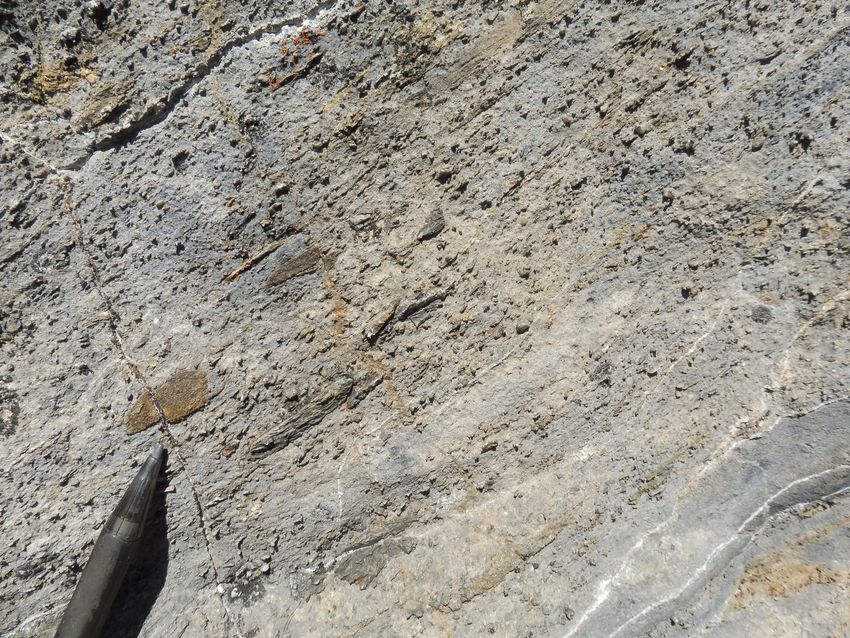
Wildgust, Cui, Clarke, and Hickin

                                                                          Open File, 1

                                                                      Partner, 3

                                                                                                                 GeoFile, 16

                                                  Paper, 11

                                                             Information
                                                             Circular, 11                            External, 12

                                                                                                                       Total = 54


                     !  "

                           #

                     " "  $  "
                          %         "
                   #          #

                   !  "   "    "
                      "&  &
                   '    ( )$  **)$   ( "  &
                   '

                            " "
                      !       "    "
                    "  !

                   "#   "      "  +
                      #

                   *    "   " !

                   **%    )$   (   "

     Fig. 2. Types and numbers of publications produced by the British Columbia Geological Survey in 2021.

     3.1.1. Northwest British Columbia                                                       support mineral exploration; understanding the stratigraphic,
       Northwest British Columbia hosts significant base- and                                magmatic, structural, metallogenic, and tectonic framework of
     precious-metal mineral deposits, notably in an area between                             this region continues to advance.
     Iskut and Stewart colloquially referred to as the ‘Golden                                 In support of Survey mapping programs in northwestern
     Triangle’. An ongoing multi-year Survey program will                                    British Columbia, Nelson et al. (2021) provided raw U-Pb
     continue to expand regional bedrock mapping coverage to                                 zircon datasets for 18 samples collected from between Dease

                                                                                         4
Geological Fieldwork 2021, British Columbia Ministry of Energy, Mines and Low Carbon Innovation, British Columbia Geological Survey Paper 2022-01
Wildgust, Cui, Clarke, and Hickin

                                                                                 Lake and Kitsault to constrain the age of intrusive and stratified
                                                                                 protoliths, age and affinity of sedimentary sources, and timing
                                                                                 of fault-related shearing.
                                                                                   Hunter et al. (2022) continued a multi-year project in the
                                                                                 Kitsault River area, south of Stewart, presenting a detailed
                                                                                 facies analysis of the local Hazelton Group volcano-
                                                                                 sedimentary depositional system, providing new U-Pb zircon
                                                                                 geochronologic data, and evaluating the implications for
                                                                                 mineralizing systems. At the southern end of the Golden
                                                                                 Triangle, the area hosts numerous Ag-rich volcanogenic
                                                                                 massive sulphide (VMS) and epithermal deposits similar to
                                                                                 those of the Eskay rift ca. 150 km to the northwest. Resolving
                                                                                 the age and affinity of late Early to Middle Jurassic volcano-
                                                                                 sedimentary Hazelton Group host rocks (Fig. 5) is key to
                                                                                 understanding the metallogeny of the Kitsault area. A new
                                                                                 U-Pb detrital zircon maximum depositional age (ca. 188 Ma)
                                                                                 from upper Hazelton Group epiclastic rocks at the Sault Zn-
                                                                                 Pb-Ag-Sr showing suggests that the VMS mineralization in the
                                                                                 Kitsault River area may be slightly older than the ca. 174 Ma
                                                                                 Au-rich VMS systems of the Eskay rift and indicates that
                                                                                 significant precious metal-bearing VMS and/or epithermal
     Fig. 3. Critical minerals virtual workshop held in November 2021. See       systems formed well outside the main Eskay rift corridor in
     British Columbia Geological Survey (2021).                                  mainly volcaniclastic rocks.

                               Tagish Lake
                                          Nakina

                                   Dease Lake
                                                          Kutcho

                                                                                                               In progress
                                                Iskut and       Johanson Lake                                  Integrated
                                            Bowser/Sustut basin

                                                                     Hogem
                                                    Kitsault
                                                   Kitsumkalum
                                                                  Decar
                                        North       Terrace                 QUEST
                                          Coast          Equity Silver Mine

                                                                   Chilcotin-Bonaparte           Bonaparte

                                North Vancouver Island                                                       Penticton
                                                                                             SNAP

     Fig. 4. BC Digital Geology, integrated and in progress.

                                                                             5
Geological Fieldwork 2021, British Columbia Ministry of Energy, Mines and Low Carbon Innovation, British Columbia Geological Survey Paper 2022-01
Wildgust, Cui, Clarke, and Hickin
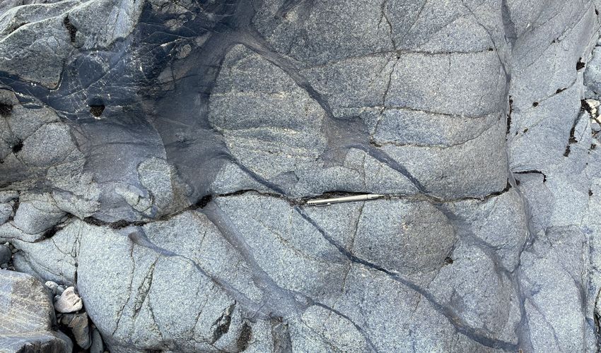
Fig. 5. Interbedded fine and course tuff from facies 6 of the upper Fig. 6. Cliff-forming mafic volcanic rocks of the Horn Mountain
Hazleton Group, Kitsault area. U-Pb detrital zircon analysis yielded Formation (upper Hazelton Group, Lower-Middle Jurassic) overlying
a maximum depositional age of ca. 168 Ma. See Hunter et al. (2022). recessive orange-weathering sedimentary rocks of the Spatsizi
Formation (Lower Jurassic, upper Hazleton Group); Cake Hill pluton
(Late Triassic) in foreground. Southeast of Dease Lake.
In the Dease Lake area, ongoing activities are geared towards
publication of a 1:100,000-scale Geoscience Map, a final
update to the BC Digital Geology database, and a GeoFile with
geochronological and lithogeochemical data. The Geoscience
Map, scheduled for publication in early 2022, will show the
bedrock geology of 5000 km2 between the community of
Dease Lake and the Stikine River, based on BCGS mapping
carried out between 2011 and 2018. Rocks in the area are
mainly in the Stikine terrane, a Paleozoic to Mesozoic island
arc that was deformed in the latest Triassic to Early Jurassic
before accreting to Ancestral North America in the Middle
Jurassic. The area experienced repeated calc-alkalic to alkalic,
arc magmatism from the Middle Triassic through the Late Fig. 7. Stuhini Group, lower fine-grained sedimentary-tuff unit.
Jurassic. This includes Tsaybahe group volcanism (Middle Interbedded argillite, plagioclase-rich, sandstone (with south-vergent
Triassic), Stuhini Group volcanism (Late Triassic), and Stikine fold), and limestone. See Stanley and Nelson (2022).
suite plutonism (Late Triassic). This magmatism was followed
by latest Triassic deformation and a latest Triassic to Early of the Golden Triangle, and a Hazelton Group stratigraphy
Jurassic depositional and magmatic hiatus that corresponds to a that is comparable to that in the McTagg anticlinorium. The
significant collisional event between the Intermontane terranes. Stuhini Group volcanic rocks are highly potassic and of
Subsequent upper Hazelton Group volcanism (Fig. 6; late Early shoshonitic affinity, and zircons from a crystal tuff near the
to Middle Jurassic), Three Sisters suite plutonism (Middle base of an upper volcanic unit yielded a crystallization age of
Jurassic), and Snowdrift Creek suite plutonism (late Middle to ca. 214 Ma, providing new evidence of shoshonitic volcanism
Late Jurassic) formed during and after accretion of Stikinia and at the transition from main-stage Stuhini arc- back-arc activity
other Intermontane terranes to Ancestral North America. As a into post-collision (Galore suite) magmatism. Zircons from
result of this protracted magmatic history, the area is prospective a siltstone unit at the base of the Hazelton Group yielded a
for intrusion-related magmatic-hydrothermal mineral deposits, maximum detrital age of ca. 201 Ma, consistent with results
as illustrated by the Gnat Pass porphyry copper deposit and from elsewhere in the Golden Triangle. Stanley and Nelson
numerous other porphyry, epithermal, and skarn prospects. (2022) consider that the diverse metallogeny of the Golden
Also in the Dease Lake area, Bouzari et al. (2021) examined Triangle resulted from collision-driven processes during
porphyry-related advanced argillic-alteration in the Horn Stuhini and Hazelton arc and back-arc development, drawing
Mountain Formation (Hazelton Group). analogies to modern-day New Britain arc and Bismarck plate
Based on mapping, geochemistry, and U-Pb zircon reorganization.
geochronology, Stanley and Nelson (2022) recognized Colpron and Nelson (2021) published an updated review
hitherto unappreciated Stuhini Group rocks (Fig. 7) in the that summarized the physiography, neotectonics, crustal
past-producing Scottie gold mine area in the southern part structure, geology, natural resources, and evolution of the
6
Geological Fieldwork 2021, British Columbia Ministry of Energy, Mines and Low Carbon Innovation, British Columbia Geological Survey Paper 2022-01
Wildgust, Cui, Clarke, and Hickin

     northern Cordillera, and George et al. (2021) used U-Pb zircon
     geochronology tied to Lu-Hf isotope analysis to consider the
     Triassic-Jurassic magmatic and accretionary history of Stikinia
     and evaluate the nature and origin of basement to Stikinia.

     3.1.2. Central, southern, and northeastern British Columbia
       Bedrock mapping updates for the provincial database and
     MapPlace are ongoing for several areas of central and southern
     British Columbia (Fig. 4): southwest Quesnellia; Bonaparte
     Lake to Quesnel River; Hogem; and Decar. An update based on
     mapping outside of Survey programs in the Penticton area of
     southern British Columbia is also in preparation.
       In August, a bedrock mapping project was initiated in the
     Lardeau area west of Kaslo Lake (Fig. 1). Rocks historically
     mapped as Lardeau Group (Fig. 8) are thought to have been                 Fig. 8. Moderately dipping metamorphic rocks of the Lardeau
     deposited on or near the North American continental slope.                Group (Paleozoic). The lower green-grey chlorite schist of the
     In the Lardeau area, the basal unit is the Index Formation,               Jowett Formation is overlain by strongly deformed sandstone and
     a commonly fine-grained carbonaceous clastic package,                     lesser carbonate of the Badshot Formation. The contact is under the
                                                                               geologist’s knee. The photograph was taken north of Kootenay Lake,
     generally considered to be Early Cambrian and overlain by                 view is to the northwest.
     mafic volcanic rocks of the Jowett Formation. In the study area,
     the Index Formation includes massive sulphide mineralization
     (Ledgend prospect) that may extend for many km, providing
     a regional exploration target for nickel, cobalt, and copper, all
     essential elements for low-carbon technologies.
       Using conodont and U-Pb detrital zircon data, Schiarizza
     et al. (2022) document how the stratigraphic break above the
     Chapperon Group 50 km southeast of Kamloops includes not
     just a sub-Triassic unconformity but an extensive sub-Jurassic
     unconformity. In the Salmon River valley, an unconformity
     separates schists of the Chapperon Group (pre-Permian) from
     less deformed limestones and siliciclastic rocks previously
     considered entirely Triassic. Rocks above the unconformity
     were previously mapped as a single Triassic unit (the Salmon
     River succession), and the Salmon River locale was considered
     to be a prime example of the Permo-Triassic unconformity
     recognized at numerous localities throughout south-central
     British Columbia. Samples collected from basal limestones                 Fig. 9. ‘Limestone unit’ with Triassic conodonts from above the sub-
     (Fig. 9) yielded conodonts that confirm a Late Triassic age for           Triassic unconformity with the Chapperon Group (Paleozoic), Salmon
                                                                               River valley. Pebbly limestone with tabular intraformational micritic
     rocks immediately above the unconformity. However, U-Pb                   limestone clasts and granules and pebbles of chert, quartz, and quartz
     detrital zircon analysis of two sandstone samples indicate that           tectonite. See Schiarizza et al. (2022).
     the Salmon River succession is not a single Triassic unit. Detrital
     zircons from near the base of the siliciclastic rocks yielded
     a maximum depositional age of ca. 183 Ma, and a sample                    of the basement to Stikinia. Ootes et al. (2022) present detrital
     collected 4.5 km to the west yielded a maximum depositional               zircon U-Pb, Lu-Hf isotope, and trace element data from the
     age of 190 Ma. These data show that most of the Salmon River              Lay Range assemblage, the lowest exposed lithostratigraphic
     succession is Jurassic, and that a more extensive sub-Jurassic            unit of north-central Quesnellia. Fossil and field evidence
     unconformity merges with the sub-Triassic unconformity.                   indicates deposition of the lower sedimentary division (Fig. 10)
     The Salmon River succession, as now defined, is tentatively               during the Late Mississippian to Middle Pennsylvanian and of
     correlated with the Hall Formation (Early Jurassic, Toarcian)             the upper mafic tuff division during the Middle Pennsylvanian
     of the Rossland Group.                                                    to early Permian. A quartz sandstone and a polymictic pebble
       Work on a multi-year mapping project in the northern part               conglomerate from the lower part of the lower sedimentary
     of Hogem batholith to better understand the origin and timing             division yielded detrital zircon U-Pb ages between 360 and
     of batholith emplacement and base- and precious-metal                     290 Ma (Carboniferous to early Permian), with a range of
     mineralization continued with further 40Ar/39Ar work, a fluid             older detrital zircons from ca. 3600 to 890 Ma (Archean and
     inclusion study, and a detrital zircon study evaluating the nature        Proterozoic). A small population of zircons ranges from 450 to

                                                                           7
Geological Fieldwork 2021, British Columbia Ministry of Energy, Mines and Low Carbon Innovation, British Columbia Geological Survey Paper 2022-01
Wildgust, Cui, Clarke, and Hickin

                                                                               The most common rock type is andesite and, although some
                                                                               andesites have high-Mg and adakite-like geochemical features
                                                                               (high Sr/Y, La/Yb), petrographic and geochemical evidence
                                                                               support that some of these rocks were derived from garnet-
                                                                               free mantle melts that mingled with garnet-free lower-crust.
                                                                               The geochemical features are consistent with amphibole,
                                                                               pyroxene, and plagioclase control resulting from mantle melts
                                                                               mixing with lower crust. The Kamloops study forms part of a
                                                                               larger project to establish the evolution of Eocene volcanism,
                                                                               help identify volcanic centres that may control the location
                                                                               of epithermal gold deposits, and estimate the contributions of
                                                                               volatile gases (e.g., CO2, SO2) to the early Eocene atmosphere.
                                                                                  To help steer future exploration efforts, the BCGS published a
                                                                               depth-to-bedrock study (Arnold, 2021) in the drift-covered area
     Fig. 10. Lay Range assemblage, lower sedimentary division. At             of the central Interior Plateau between the Mount Polley and
     bottom of photo, sharp-based Bouma-like fining upward sequences of        Mount Milligan porphyry deposits. This project used published
     graded siltstones to dark grey argillites. See Ootes et al. (2022).       data including drill hole, bedrock, and surficial geology maps.
                                                                               Lett and Paulen (2021) published a compilation of soil and till
     390 Ma (Ordovician to Devonian). The Carboniferous detrital               geochemical data for two mineral properties in south-central
     zircons have mostly juvenile εHf(t), indicating that the parental         British Columbia, the Ace, a massive sulphide and quartz vein
     magmas did not interact with older crust. The combined                    showing, and Getty South a porphyry copper prospect.
     εHf(t) and trace element compositions of detrital zircons                    Working in northeastern British Columbia, Ferri et al. (2021)
     are consistent with formation in a juvenile arc during the                provided a stratigraphic overview of the Liard basin and
     Carboniferous. Comparison of Lay Range detrital zircon U-Pb,              its eastern neighbour, the Horn River basin, focussing on
     Hf, and trace element systematics indicate a similar timing               organic-rich Upper Devonian shales of the Patry and Exshaw
     of arc magmatism with eastern Stikinia and Wrangellia, but                formations (Besa River Group) in the subsurface of Liard basin,
     little relationship to ancient North America or Yukon-Tanana              and highlighting features that make the interval an exceptional
     terrane. The older detrital zircons (Archean through Paleozoic)           shale gas play. Presenting whole rock, trace and rare earth
     were sourced from a fringing landmass, possibly a continental             element geochemistry, mineralogical, Rock-Eval, and U-Pb
     oceanic plateau, that had little to no role in the petrogenesis of        zircon data, Ferri et al. (2021) concluded that organic-rich
     the Carboniferous magmas. The spread of ages in the Lay Range             Patry shales reflect establishment of anoxic bottom waters
     assemblage zircon distributions likely records multiple cycles            that spread across much of the Western Canada Sedimentary
     of deposition, uplift, erosion, transport, and sedimentation.             Basin as transgression peaked during deposition of the Exshaw
     One possibility is that the fringing landmass was calved during           Formation. Integrating aeolian landform analysis with optical
     rifting of the western edge of North American crust covered               dating and macrofossil radiocarbon dating, Hickin et al. (2021)
     by Neoproterozoic through Cambrian passive margin deposits.               examined the paraglacial to non-glacial transition following the
        Field mapping of northern Hogem batholith and adjacent                 Late Wisconsinian separation of the Cordilleran and Laurentide
     intrusive, volcanic, and sedimentary rocks of the Stikine and             ice sheets in northeastern British Columbia.
     Cache Creek terranes was completed in 2019. Publication of
     bedrock and surficial maps is anticipated in the first half of 2022
     and will be accompanied by an update to BC Digital Geology.
        Van Wagoner and Ootes (2022) and Van Wagoner et al. (2021)
     report on the geology and geochemistry of the Kamloops Group,
     which forms part of a discontinuous northwest-trending belt
     of Eocene volcanic and sedimentary rocks that extends from
     central Idaho to eastern Alaska. In the Kamloops Group type
     area, these rocks constitute the Tranquille Formation (Fig. 11)
     and the overlying Dewdrop Flats Formation, each of which
     are divided into a number of members. Field, petrographic,
     and whole rock major, trace, and rare earth element data
     indicate that many members have comparable compositions
     and volcanic facies whereas others differ with geographic
                                                                               Fig. 11. Hoodoos carved into andesitic to dacitic tuffs, lahars, and
     location, possibly reflecting various feeder vents. The volcanic          lacustrine volcaniclastic deposits, upper member of the Tranquille
     rocks range from basaltic andesite to dacite; minor rhyolite              Formation (Eocene, Kamloops Group). View to the northwest; outcrop
     occurs west of the type area in the Mount Savona Formation.               within Kamloops city limits. See Van Wagoner and Ootes (2022).

                                                                           8
Geological Fieldwork 2021, British Columbia Ministry of Energy, Mines and Low Carbon Innovation, British Columbia Geological Survey Paper 2022-01
Wildgust, Cui, Clarke, and Hickin

     3.2. Targeted deposit studies and exploration methods                    apatite, illite and smectite, and sulphide minerals were found in
       Regional mapping programs are complemented by more                     trace to small amounts in most samples. Iron is most commonly
     specific or thematic studies, typically selected to develop              hosted in carbonate minerals. Calcium occurs mainly in
     public geoscience knowledge and datasets in key topics that              feldspars, phosphate minerals, and micas. Magnesium is held
     support minerals exploration or government land-use policy.              mainly in siderite. The ash chemistry of Willow Creek mine
     Survey geoscientists test new technologies that can support              samples is generally similar to that of Gething Formation
     future regional mapping and mineral exploration activities.              samples regionally, except that on average the Willow Creek
                                                                              mine samples contain about 50% less iron, and about 80%
     3.2.1. Deposit studies                                                   more phosphate.
        Spence et al. (2022) describe work on the Late Triassic                  Critical minerals are an important focus for the Survey,
     Tulameen intrusion, an 18 by 6 km ultramafic-mafic body                  given the increasing demand for materials needed for low-
     in the Quesnel terrane of southern British Columbia hosted               carbon technologies and the accelerated pace of global
     by metavolcanic and metasedimentary rocks of the Nicola                  investigations. L. Simandl et al. (2021) provided an overview
     Group (Upper Triassic). The intrusion is zoned with a dunite             of the implications for exploration and mining from growing
     core passing outwards through olivine clinopyroxenite and                demands for battery, magnet, and photovoltaic technologies.
     clinopyroxenite to hornblende clinopyroxenite and hornblendite           G. Simandl et al. (2021) examined the Rock Canyon Creek
     at the margin. Fieldwork conducted by the University of British          carbonate-hosted REE-F-Ba deposit, which has tectonic,
     Columbia during the summer of 2021 incorporated bedrock                  stratigraphic, and structural similarities with Mississippi
     mapping and sampling with the assistance of remotely piloted             Valley-type and sparry magnesite deposits in the southeastern
     aircraft systems (RPAS) to examine relationships between                 Rocky Mountains. In 2022, the Survey will examine critical
     the ultramafic rock types during a period of low water in the            minerals systems and develop a provincial inventory based on
     Tulameen River. Zones of intermingled ultramafic cumulates               the federal government list (Natural Resources Canada, 2021).
     (Fig. 12) are typical of the section and are interpreted to be
     the result of magma recharge and remobilization of crystal-              3.2.2. Exploration methods
     rich magma mushes across a range of physical and rheological                The Survey is testing remotely piloted aircraft systems
     conditions.                                                              (RPAS) to acquire geological data. Following up on RPAS-
        Milidragovic et al. (2021) examined the chalcophile element           generated photogrammetric digital elevation models (DEMs)
     geochemistry at the Polaris Alaskan-type mafic-ultramafic                to support surficial geology mapping (Elia and Ferbey,
     complex and concluded that two styles of PGE mineralization              2020), work in 2021 investigated the utility of RPAS-born
     reflect the evolution of strongly oxidized hydrous ultramafic            magnetometry and gamma-ray spectrometry devices to detect
     parental magma(s) in the absence of wall rock assimilation.              porphyry-related dispersal trains in subglacial tills.
        Riddell et al. (2021) reported on the analysis of ten Gething            Regional-scale till geochemistry and mineralogy surveys
     Formation coal samples from the Willow Creek mine in the                 in British Columbia can have a low sample density (e.g.,
     Peace River coalfield of northeastern British Columbia, using            1 sample/10 km2) compared to other geochemical prospecting
     the TESCAN Integrated Mineral Analyzer system to identify                methods. Traditional magnetic and radiometric surveys can
     and quantify the mineralogy of non-carbonaceous material.                provide insight into subglacial till compositions between
     Quartz, kaolinite, feldspars and siderite are most abundant;             sample locations, but are commonly costly, time-consuming,
     micas, other carbonate minerals, crandallite group minerals,             or have a poor spatial resolution. Remotely piloted aircraft
                                                                              systems offer the potential to collect fast, affordable, and high-
                                                                              resolution data for drift prospecting studies.
                                                                                 The tests, the detailed results of which will be presented
                                                                              elsewhere, included flights totalling 155 line-km over
                                                                              subglacial tills in seven forestry cutblocks near the Mount
                                                                              Polley mine (alkalic porphyry Au-Cu) and the Woodjam
                                                                              developed prospect (calc-alkaline to alkalic porphyry Cu-Au).
                                                                              Existing geology, geochemistry, mineralogy, and geophysical
                                                                              datasets provide geologic control and a way of validating newly
                                                                              acquired RPAS-borne data. Infill till sampling supplemented
                                                                              these data. The RPAS flew gridded autopilot surveys at 5,
                                                                              7.5, or 10 m above ground level (AGL) at 2 m/s along flight
                                                                              lines spaced 7.5 or 10 m apart. A GEM Systems DRONEmag
                                                                              potassium magnetometer was slung 2.5 m below a DJI Matrice
     Fig. 12. Tulameen Alaskan-type ultramafic-mafic intrusion (Upper
     Triassic), network of small dunite dikes with cuspate-lobate and
                                                                              600 Pro (Fig. 13a) and using a 10 Hz sampling rate collected
     flame-like margins projecting from a dunite enclave. See Spence et       total field measurements every 20 cm on the ground. Radiation
     al. (2022).                                                              Solutions Incorporated provided a repackaged version of their

                                                                          9
Geological Fieldwork 2021, British Columbia Ministry of Energy, Mines and Low Carbon Innovation, British Columbia Geological Survey Paper 2022-01
Wildgust, Cui, Clarke, and Hickin

                      D                                                           E


                      F

     Fig. 13. a) A GEM Systems DRONEmag potassium magnetometer tethered 2.5 m below a DJI Matrice 600 Pro flying a gridded autopilot survey
     7.5 m above ground level. b) A Radiation Solutions Incorporated RS-350 Backpack gamma-ray spectrometer, incorporating a 3”x3” NaI (Tl)
     crystal, retrofitted to a DJI Matrice 600 Pro. c) The hardware used to complete the geophysical, lidar, and photogrammetric surveys: 1. DJI
     Phantom 4 RTK batteries, 2. air-band handheld VHF radios, 3. magnetometer mount for DJI Matrice 600, 4. tools, VFR navigation charts, and
     manuals, 5. GreenValley International LiAir V70 lidar and base station, 6. laptop running GreenValley International LIDAR360 and LiAcquire
     software, 7. Radiation Solutions Incorporated gamma-ray spectrometer, 8. GEM Systems DRONEmag magnetometer, 9. laptop running SPH
     Engineering UgCS flight planning software, 10. DJI Phantom 4 RTK and base station, 11. DJI Matrice 600 Pro, 12. GSM19-G walking (base
     station) magnetometer, 13. DJI Matrice 600 Pro batteries, 14. RTK base station tripod, and 15. lidar base station tripod.

     RS-350 backpack gamma-ray spectrometer that was mounted                      large-scale surficial geology mapping and be used to interpret
     directly to a DJI Matrice 600 (Fig. 13b). This instrument uses a             ice-flow and till-transport histories. For example, glacially
     3”x3” NaI (Tl) crystal with a 1 Hz sampling rate to collect total            streamlined features, which indicate northwest ice flow
     count data every 2 m. An SPH Engineering radar altimeter,                    through the Woodjam area during the Late Wisconsinan, are
     coordinated with UgCS flight planning software, instructed the               readily identified in RPAS lidar bare Earth models (Fig. 14a).
     RPAS in real time to follow terrain at a constant height AGL,                These features cannot be mapped with confidence using RPAS
     ensuring measured data variation was unrelated to changes                    photogrammetric DEMs or orthomosaics (Figs. 14b, c), and are
     in distance between the geophysical sensors and the ground.                  not visible in pre-cutblock, 1:40,000-scale hardcopy air photos
     Acquired geophysical data were corrected and gridded using                   (Ferbey et al., 2016) in which trees obscure the subtle changes
     conventional methods for traditional airborne magnetic and                   in topography that define these landforms.
     radiometric surveys.                                                            The project demonstrates that commercially available
       Lidar and air photo surveys were flown for the same areas at               hardware and software can be integrated to fly low-altitude,
     4 m/s and 80 m AGL, using a GreenValley International Liair                  terrain-following RPAS geophysical surveys (Fig. 14c). The
     V70 lidar (mounted to a DJI Matrice 600 Pro) and a DJI Phantom               magnetic and radiometric data collected are high quality
     4 RTK. High-resolution bare Earth DEMs were produced from                    and fill a scale gap between traditional airborne and ground
     these data, as were orthomosaics (Fig. 14). These models and                 surveys. Furthermore, RPAS-acquired lidar data are invaluable
     RPAS-derived digital air photo stereo pairs will supplement                  for mapping surficial geology in forested terrain. Work

                                                                             10
Geological Fieldwork 2021, British Columbia Ministry of Energy, Mines and Low Carbon Innovation, British Columbia Geological Survey Paper 2022-01
Wildgust, Cui, Clarke, and Hickin
planned for 2022 will continue to focus on differentiating the
radiometric and magnetic signals of subglacial tills derived
from potassium- and magnetite-rich porphyry systems relative
7E to those derived from country rocks, and will investigate the
ability of the method to identify subglacial tills sourced from
7V
D other critical mineral hosts such as magmatic Ni±Cu±Co±PGE
systems.
7E Based on fieldwork in the summer of 2021, Rukhlov et
;
;
al. (2021, 2022) report new data from the Lara-Coronation
polymetallic occurrence, southern Vancouver Island,
confirming that direct and continuous analysis of gaseous
elemental mercury (GEM) concentrations in near-surface air
using a portable RA-915M Zeeman Hg analyzer can map
sediment-covered mineralization in real time. Detailed surveys
across steeply dipping, massive sulphide zones in volcanic
rocks of the McLaughlin Ridge Formation (Sicker Group;
Middle to Late Devonian) confirm GEM haloes in near-surface
air above the mineralization. Measured GEM concentrations
E range from 0.61 to 251 ng·m-3 in this study, with the strongest
halo (206x background Hg) above exposed mineralization.
Weak haloes (1.7x background Hg) mark sediment-covered
mineralized zones. Simultaneously measured meteorological
and in situ soil parameters appear to have no effect on
measured GEM concentrations. Real-time grid sampling of
near-surface air reveals a pattern of northwest-trending GEM
haloes reflecting bedrock structure, including a 224 by 30 m
halo above the polymetallic VMS Coronation zone, covered by
up to 22 m of overburden. This study confirms that the real-
time GEM sampling of near-surface air can instantly delineate
mineralized zones that are buried beneath overburden 10s of
m thick. Real-time GEM sampling is a simple and effective
F technique for mineral exploration in overburden-covered areas.
4. Resource Information Section
The Survey collects, compiles, and disseminates provincial
public geoscience information that supports effective mineral
exploration, sound land use management, and responsible
governance. This public geoscience includes traditional
geological maps, reports, and thematic studies, province-wide
digital coverage (BC Digital Geology), and databases including
mineral assessment reports (ARIS), mineral inventory
(MINFILE), coal information (COALFILE), geochemical
and geophysical surveys, and documents donated to the
PHWUHV British Columbia Geological Survey since the late 1880s by
government, universities, industry, and individuals (Property
Fig. 14. a) Bare Earth digital elevation model (DEM) of a forestry File). The Survey operates numerous information systems to
cutblock west of Woodjam developed prospect, processed from lidar
data acquired by LiAir V70 mounted to DJI Matrice 600 Pro. Glacially update these databases and deliver them through MapPlace, the
streamlined landforms (or streamlined till; Ts) indicate northwest ice BCGS geospatial web service, and other web portals.
flow during the Late Wisconsinan and can be differentiated from Although the Survey has a long history of digitally compiling
areas of thicker till (till blanket; Tb). Chilcotin Group (Miocene to and managing geoscience, many of the information systems
Pleistocene) olivine-phyric basalt outcrops observed in the field
marked with ‘X’. The streamlined features are unmappable in the require modernization. As part of digital transformation efforts
b) orthomosaic or c) photogrammetric DEM generated from RPAS- (Fig. 15), we are modernizing our core information systems to
acquired air photos for the same area. Truck is circled in red. increase efficiency in operating and updating our geoscience
11
Geological Fieldwork 2021, British Columbia Ministry of Energy, Mines and Low Carbon Innovation, British Columbia Geological Survey Paper 2022-01Wildgust, Cui, Clarke, and Hickin
Digitization Digitalization Digital
Transformation
Input Output Outcomes
Geological mapping, Digital geology (f_meta) Framework geoscience
Data field data, lab analyses, Mineral resources (f_meta) Interoperable data sharing
ARIS, MINFILE Mineral systems (f_meta) HTML5 compliant web services
Digitizing Automated integration Automated transformations
Process Updating Knowledge engineering Mineral potential modelling
Compiling
Spatial Data Geoscience Operational Geoscience Application MapPlace 3, OpenLayers
Infrastructure Database Environment Database Environment OGC web services, OneGeology
(SDI) (GODE) (GADE)
Bedrock and surficial Cordilleran geology Open standards-based web
Skills and geological mapping, Mineral systems services
knowledge geochemistry, geophysics, Data-driven interpretation Digital cartography
needed mineral deposits, GIS, Spatial databases Geostatistics, data science
database systems Data modelling
Fig. 15. Digital transformation of BCGS data.
databases, applications, and geospatial web services. This 4.3. ARIS assessment reports and database
modernization will enable interoperable data sharing and Results of mineral exploration are submitted by industry as
applications such as mineral potential modelling. assessment reports to the government in compliance with the
Mineral Tenure Act. After a one-year confidentiality period,
4.1. Geoscience Spatial Data Infrastructure the assessment reports become freely available to public.
Recent advancements in data science demand interoperable The Survey manages these reports in the Assessment Report
data sharing of framework geoscience. The Survey is identifying Indexing System (ARIS) database with metadata to search the
opportunities and prioritizing solutions to improve our digital locations, mineral occurrences, commodities, claims, work
capabilities. We are conducting a review of all geoscience types, and expenditures as documented in the reports. ARIS
databases and applications to define a system architecture and contains more than 38,500 reports dating from 1947. The
ways to implement a geoscience Spatial Data Infrastructure assessment reports are available online as PDF documents
(SDI). The SDI will be built by following the ‘FAIR’ principles: through the ARIS website. A version of the ARIS database for
Findable, Accessible, Interoperable, and Reusable. Our short- the metadata is available to download in Microsoft Access,
term goal is to modernize a few core information systems with with locations in Microsoft Excel and ESRI shapefile format.
a coherent operational database environment and upgraded Data in formats that can be readily used, such as spreadsheets,
web applications. rather than scanned .PDF files, from 620 assessment reports
are available through the ARIS search application. Following
4.2. MapPlace work in the Interior Plateau (Norris and Fortin, 2019), the
MapPlace is the BCGS geospatial web service to discover, Survey continues to digitally extract assessment report-sourced
visualize, search, and generate summary reports and maps surface sediment geochemical data (ARSSG), extending
from province-wide geoscience databases. Easy access to, into northwestern British Columbia. The database currently
and analysis of, geoscience maps and data are fundamental to contains more than 6.6 million determinations from more
inform decisions on mineral exploration, mining, environmental than 163,000 samples from 550 assessment reports. The data
protection, and land use management. MapPlace provides are incorporated into MapPlace and are also available on the
a platform to facilitate the discovery, display, search, and ARSSG website, which includes sample details, geochemical
analysis of geoscience information in the context of all other results, and locations. Another project is underway to extract
relevant data such as mineral titles, assessment reports, land digital data from drillhole logs and geophysical surveys sourced
ownership, public infrastructure, aquifers, and topographic base from assessment reports.
maps. Some of the advanced applications and user interfaces
are specifically designed to enable research and analytics for 4.3.1. ARIS digital data submission
mineral exploration and prospecting. Traditionally, assessment reports from mineral exploration
12
Geological Fieldwork 2021, British Columbia Ministry of Energy, Mines and Low Carbon Innovation, British Columbia Geological Survey Paper 2022-01Wildgust, Cui, Clarke, and Hickin
have been submitted in hardcopy or as files such as scanned
.PDF, which render data within the files difficult to extract
and use. The BCGS has set up a digital data submission portal
to encourage inclusion of digital files such as spreadsheets,
databases, GIS maps, and grids. Explorationists will benefit
because digital data can be easily retrieved, integrated, and
recast for specific needs. Digital submission will also enable
the Survey to better maintain province-wide databases and
create derivative products that use past results to guide future
exploration. Both assessment reports and digital data can be
uploaded through the ARIS data submission page.
4.4. Other databases
MINFILE is a database for mineral, coal, and industrial
mineral occurrences that includes information for more than
15,500 records. In the last year, more than 400 new occurrences
and 2100 updates were added to the database. COALFILE
includes a collection of 1040 coal assessment reports, dating
from 1900. Associated data include 16,100 boreholes, 550
bulk samples, 5400 maps, 3650 trenches, and 484 coal ash
chemistry analyses. Property File is a collection of more than
Fig. 16. The geospatial frame data (GFD) model and integration
85,000 archived reports, maps, photos, and technical notes processes can be applied to any discipline that has polygons and lines
documenting mineral exploration activities in British Columbia to compile and produce digital map. See Cui (2021).
from the late 1800s. The provincial geochemical databases
hold field and geochemical data from multi-media surveys by
interface such as WMS and WFS, to enable interoperable data
the Geological Survey of Canada, the BCGS, and Geoscience
sharing and analytics.
BC. The databases are updated regularly and contain results
from: 1) the Regional Geochemical Survey program (RGS)
including analyses from more than 66,000 stream-sediment, 4.6. Mineral potential modelling
lake sediment, moss, and water samples (Han and Rukhlov, The British Columbia Geological Survey has initiated a
2020a); 2) 10,500 till surveys (Bustard et al., 2017, 2019); and multi-year mineral potential mapping project. The principal
3) 11,000 lithogeochemical samples (Han and Rukhlov, 2020b). aim of the project is to identify areas of high prospectivity for
A surficial geology index map for the province (Arnold and key mineral systems across the province to assist government
Ferbey, 2019) is regularly updated as is an ice-flow indicator with land-use planning and deliver pre-competitive geoscience
database for British Columbia and Yukon (Arnold and Ferbey, data to the mineral exploration industry. The initial phase of
2020). the project included a pilot study that focussed on method
development in a test area. Three mineral systems were chosen
4.5. British Columbia Digital Geology for the pilot study: porphyry copper-gold; volcanic massive
The BCGS offers province-wide digital coverage of bedrock sulphide (VMS) copper-lead-zinc; and magmatic nickel. A
geology including details from field mapping, with a typical weights-of-evidence method was adopted, which produced
regional compilation at a scale of 1:50,000. A geospatial data-driven mineral potential maps for each selected mineral
frame data (GFD) model is used to simplify the compilation system. This method allowed for a comprehensive review of
and integration of new mapping into the BC Digital Geology outputs at every stage of the modelling process to ensure that
database (Fig. 16, Cui, 2021). Bedrock geology is standardized the maps were geologically sensible and statistically valid.
with consistent stratigraphic coding, ages, and rock types Based on the success of the pilot study, modelling will continue
to enable computations, and is available for download in into new areas and include more mineral systems in the coming
GeoPackage and ESRI shapefile formats. Customized bedrock years.
geological maps and legends can be explored, and data
downloaded as KML by spatial and non-spatial queries via 5. Mineral Development Office
MapPlace. The BCGS has transformed the digital geology to The Mineral Development Office (MDO) is the Vancouver
the GeoSciML Lite schema and mapped the contents using base of the British Columbia Geological Survey, linking the
the vocabularies adopted by the IUGS Commission for the more than 800 exploration and mining companies headquartered
Management and Application of Geoscience Information in Vancouver to provincial mineral and coal information. The
(CGI). The GeoSciML Lite-compliant digital geology is MDO distributes Survey data and provides technical information
accessible via the OneGeology portal and open standard-based and expertise about mineral opportunities to the domestic and
13
Geological Fieldwork 2021, British Columbia Ministry of Energy, Mines and Low Carbon Innovation, British Columbia Geological Survey Paper 2022-01Wildgust, Cui, Clarke, and Hickin
international investment community. The MDO monitors the information on exploration trends, possible investment
activities of the mining and exploration sectors and produces opportunities, land use processes, First Nation capacity
the Provincial Overview of Exploration and Mining in British building, and public outreach. In 2020, the Regional Geologists
Columbia, an annual volume that summarizes activities in the were repatriated to the BCGS as part of the MDO.
different regions of the province (see e.g., Clarke et al., 2022).
The British Columbia Regional Geologists (Table 1) Acknowledgment
represent the provincial government on geological matters at We thank George Owsiacki of Total Earth Science Services
a regional level and capture information on industry activity (Victoria) for the desktop publishing of this volume.
in their jurisdictions. Within their communities, they provide
Table 1. British Columbia Regional Geologists.
Regional Geologist Office Region
Vacant Smithers Northwest
Nate Corcoran Prince George Northeast and North Central
Vacant Kamloops South Central
Fiona Katay Cranbrook Southeast
Bruce Northcote Vancouver Southwest
References cited Cui, Y., 2021. A geospatial frame data model to simplify digital map
Arnold, H., 2021. Depth to bedrock dataset for the Interior Plateau. compilation and integration. British Columbia Ministry of Energy,
Ministry of Energy, Mines and Low Carbon Innovation, British Mines and Low Carbon Innovation, British Columbia Geological
Columbia Geological Survey GeoFile 2021-13, 6 p. Survey Paper 2021-03, 20 p.
Arnold, H., and Ferbey, T., 2019. British Columbia surficial geology Elia, E.A., and Ferbey, T., 2020. Generating photogrammetric DEMs
map index, British Columbia Ministry of Energy, Mines and in the field from remotely piloted aircraft systems. In: Geological
Petroleum Resources, British Columbia Geological Survey Open Fieldwork 2019, British Columbia Ministry of Energy, Mines and
File 2019-03, Data version 2020-01. Petroleum Resources, British Columbia Geological Survey Paper
Arnold, H., and Ferbey, T., 2020. Ice-flow indicator database, British 2020-01, pp. 189-200.
Columbia and Yukon. British Columbia Ministry of Energy, Mines Ferbey, T., Levson, V.M., and Plouffe, A., 2016. Surficial geology,
and Petroleum Resources, British Columbia Geological Survey Moffat Creek area, British Columbia, parts of NTS 93-A/3, NTS
Open File 2020-03, 1 p. 93-A/4, NTS 93-A/5, NTS 93-A/6. Geological Survey of Canada,
Bouzari, F., Lee, R.G., Hart, C.J.R., and van Straaten, B.I., 2021. Canadian Geoscience Map 252 (preliminary), British Columbia
Mineralogical and geochemical vectors within advanced argillic- Ministry of Energy, Mines, and Petroleum Resources, British
altered rocks of north-central British Columbia (NTS 094E/02, Columbia Geological Survey Geoscience Map 2016-1, scale
15, 104I/05). In: Geoscience BC Summary of Activities 2020: 1:50,000.
Minerals, Geoscience BC, Report 2021-01, pp. 91-104. Ferri, F., McMechan, M., Richards, M.B., and Friedman, R., 2021.
British Columbia Geological Survey, 2021. Critical minerals: Organic-rich Upper Devonian shales of the Patry and Exshaw
From discovery to supply chain, program with abstracts. British formations (Besa River Group) in the subsurface of Liard basin.
Columbia Ministry of Energy, Mines and Low Carbon Innovation, British Columbia Ministry of Energy, Mines and Low Carbon
British Columbia Geological Survey GeoFile 2021-14, 74 p. Innovation, British Columbia Geological Survey Paper 2021-02,
Bustard, A.L., Han, T., and Ferbey, T., 2017. Compiled till 42 p.
geochemical data for British Columbia. British Columbia Ministry George, S.W.M., Nelson, J.L., Alberts, D., Greig, C.J., and
of Energy, Mines and Petroleum Resources, British Columbia Gehrels, G.E., 2021. Triassic-Jurassic accretionary history and
Geological Survey GeoFile 2017-09, 7 p. tectonic origin of Stikinia from U-Pb geochronology and Lu-Hf
Bustard, A.L., Ferbey, T., and Arnold, H., 2019. Regional- to isotope analysis, British Columbia. Tectonics, 40.
British Columbia for base and precious metals. British Columbia Han, T., and Rukhlov, A.S., 2020a. Update of the provincial Regional
Ministry of Energy, Mines and Petroleum Resources, British Geochemical Survey (RGS) database at the British Columbia
Columbia Geological Survey Open File 2019-04 version 2020-01. Geological Survey. British Columbia Ministry of Energy, Mines
Clarke, G., Northcote, B., Katay, F., and Tombe, S.P., 2022. and Petroleum Resources, British Columbia Geological Survey
Exploration and Mining in British Columbia, 2021: A summary. GeoFile 2020-08, 3 p.
In: Provincial Overview of Exploration and Mining in British Han, T., and Rukhlov, A.S., 2020b. Update of rock geochemical
Columbia, 2021. British Columbia Ministry of Energy, Mines and database at the British Columbia Geological Survey. British
Low Carbon Innovation, British Columbia Geological Survey, Columbia Ministry of Energy, Mines and Petroleum Resources,
Information Circular 2022-01, in press. British Columbia Geological Survey GeoFile 2020-02, 4 p.
Colpron, M., and Nelson, J.L., 2021. Northern Cordillera: Canada Hickin, A.S., Lian, O.B., Telka, A., Levson, V.M., and Marten
and Alaska. In: Elias, S., and Alderton, D., (Eds.), Encyclopedia of Geertsema, M., 2021. Geomorphic and ecological age constraints
Geology, Second Edition. Academic Press, pp. 93-106. for paraglacial to non-glacial transition in northeastern British
14
Geological Fieldwork 2021, British Columbia Ministry of Energy, Mines and Low Carbon Innovation, British Columbia Geological Survey Paper 2022-01You can also read


