UNIFIED PLANNING WORK PROGRAM (UPWP) FOR THE LOWER CONNECTICUT RIVER VALLEY COUNCIL OF GOVERNMENTS
←
→
Page content transcription
If your browser does not render page correctly, please read the page content below
FISCAL YEAR 2020-2021
       UNIFIED PLANNING WORK PROGRAM (UPWP)
                        FOR THE
LOWER CONNECTICUT RIVER VALLEY COUNCIL OF GOVERNMENTS

             Metropolitan Planning Organization

                              May 2019

          Lower Connecticut River Valley Council of Governments
                          145 Dennison Road
                       Essex, Connecticut 06426
                             (860) 581-8554
                      E-mail: info@RiverCOG.org
RIVERCOG UNIFIED PLANNING WORK PROGRAM (UPWP) FY 2020-2021

                                   TABLE OF CONTENTS

                                                                       Page

Prospectus                                                             2

Staff Outline                                                          4

Important Issues                                                       7

FAST Act Planning Goals                                                13

Transportation and Integration of FAST Act Objectives                  15
      Task 1 – Management of Planning Process                          15
      Task 2 – Data Collection – General Collection and Analysis       16
      Task 3 – Planning Activities                                     19
      Task 4 - Other Technical Assistance                              25
      Task 5 - Public Information and Involvement                      26
               (Title VI and Environmental Justice)

Financial Plan                                                         30
       Table I - Staff Hours & Budget FY 2020 & 2021                   30
       Table II – Maximum Hourly Rates for Staff FY 2020 & 2021        31
       Table III – Financial Responsibility by Task FY 2020 & 2021     31
       Table IV - Staff Hours & Budget FY 2016 Carryover               32
       Table V – Maximum Hourly Rates for Staff FY 2016 Carryover      33
       Table VI – Financial Responsibility by Task FY 2016 Carryover   33

Appendices:                                                            34
      Roles and Responsibilities                                       34
      Resolutions                                                      41

                                               1
RIVERCOG UNIFIED PLANNING WORK PROGRAM (UPWP) FY 2020-2021

                    UNIFIED PLANNING WORK PROGRAM (UPWP)
                           Lower Connecticut River Valley
                              Council of Governments
                                    (RiverCOG)

                                                                                            May 2019

PROSPECTUS
The Prospectus is a detailed description which serves as administrative and fiduciary support to the
Lower Connecticut River Valley Council of Governments (RiverCOG) as well as the cooperative and
integrative concept involved in the preparation of the Fiscal Year 2020-2021 Unified Planning Work
Program (UPWP) for the Lower Connecticut River Valley Region. It defines the regionally agreed
upon planning priorities and the roles and responsibilities of the various participants in the
metropolitan planning process. The Prospectus complements the annual work program and provides
a narrative that outlines the region's anticipated transportation agenda and linkage to the many
planning issues facing the RiverCOG’s metropolitan area.

RiverCOG Metropolitan Planning
Organization (MPO) encompasses
seventeen towns with a combined 2010
Census population of over 175,000
people and a land area of approximately
460 square miles. RiverCOG’s MPO is
comprised of the seventeen Chief Elected
Officials from the towns within the
RiverCOG region, a representative from
the Middletown Transit District, a
representative from the Estuary Transit
District, and a representative from the
Middlesex Chamber of Commerce
representing business and freight
interests.

The forum for the cooperative decision
making, with regard to transportation
planning, rests with this designated
RiverCOG - MPO and is supported
through assistance from RiverCOG staff,
the Estuary Transit District staff and
Middletown Transit District staff, and voluntary cooperation from planning staff from several of the
member towns. The region partners with neighboring Council of Governments (COGs) that serve as

                                                  2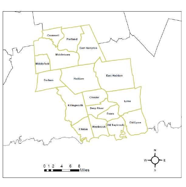
RIVERCOG UNIFIED PLANNING WORK PROGRAM (UPWP) FY 2020-2021

regional planning organizations in Connecticut, CTDOT, FHWA and FTA in the delivery of planning and
construction services to promote an interconnected statewide transportation network.

RiverCOG’s neighboring COGs include: South Central Regional Council of Government (SCRCOG), the
Southeastern Connecticut Council of Governments (SCCOG), and the Capitol Region Council of
Governments (CRCOG). Together, these regions work cooperatively toward improving mutual
transportation goals and improving connectivity for the New Haven Transportation Management
Area (TMA), the Hartford Transportation Management Area (TMA), and the Southeastern
Transportation Management Area (TMA). This includes bridging transportation networks within the
lower Connecticut River valley region; a region which connects the urbanized areas of Hartford, New
Haven, and New London. The RiverCOG works to facilitate long range, sustainable transportation
management including: infrastructure improvements, maintenance, safety, environmental resource
management and preservation, emergency management planning, land use analysis, economic
growth, and sustainable capital planning.

Federal legislation governing the Metropolitan Planning process has been regulated by the 1991
enactment of the Intermodal Surface Transportation Efficiency Act (ISTEA), the 1998 Transportation
Equity Act for the 21st Century (TEA-21), the Safe, Accountable, Flexible, Efficient Transportation
Equity Act: A Legacy for Users (SAFETEA-LU) of 2005, Moving Ahead for Progress in the 21st Century
(MAP21) of 2012 and Fixing America's Surface Transportation Act or “FAST Act” of 2015 continues to
promote the role of Metropolitan Planning Organizations in long range transportation planning.
These authorization acts are essential to the foundation of the Federal-aid Highway Program (FAHP)
since they provide funding for and the requirements associated with the FAHP. They also set forth
the duties and functions of an agency or program, its organizational structure, and the
responsibilities of agency or program officials including transforming the policy and programmatic
framework for investments to guide the growth and development of the country's vital
transportation infrastructure. Most authorization acts are multi-year acts that contain provisions for
not only the FAHP, but for other surface transportation modes, such as transit.

MPOs, outlining the planning requirements associated with the metropolitan planning process, are
charged with numerous responsibilities such as the region’s Transportation Improvement Program
(TIP) and the Long-Range Transportation Plan (LRP). Other planning tasks include; congestion
management, air quality, safety planning, transportation alternatives, system preservation, freight
planning, homeland security, environmental justice, performance measures, broader based public
participation/outreach efforts and inter-agency consultation and coordination.

The primary focus of the RiverCOG’s Unified Planning Work Program for Fiscal Years 2020-2021 will
be to administer and implement the planning requirements of the MPO. Tasks will include designing
and implementing new programs that address maximization of existing assets and mitigation of
deficiencies identified in the 2019 Metropolitan Transportation Plan (MTP). Work will include more
comprehensive analysis for the next update to the MTP, a new Transportation Improvement Program
(TIP), completing and implementing recommendations in a new Bicycle and Pedestrian Plan,
completion of the RT 66 Corridor Study, and commencement of a Regional Transit Integration Study.
The MPO will also assist with a comprehensive operations analysis for transit, emergency
transportation planning, special study of significant regional corridors, and the associated research to
develop these new documents. Another priority for 2020-2021 UPWP is the associated studies and
research to support the integration of the Regional Transportation Plan and associated research into
the Regional Plan of Conservation and Development. Research will include: demographic analysis,

                                                   3
RIVERCOG UNIFIED PLANNING WORK PROGRAM (UPWP) FY 2020-2021
underserved population sectors, economic growth and valuation analysis, land use analysis, mapping,
freight movement, environmental and conservation research, intermodal and transit analysis, land
use patterns to ameliorate existing and future congestion, river and waterway transportation modes,
travel demand, and other associated research. The research completed for this plan will be valuable
for the next update of the region’s Transportation Plan.
The RiverCOG MPO is responsible for conducting the continuing, cooperative and comprehensive (3-
C) transportation planning process for the lower river valley metropolitan region in accordance with
the metropolitan planning requirements of Section 134 (Title 23 U.S.C.) of the Federal Highway Act of
1962 and Section 8 of the Federal Transit Act.
The UPWP is developed bi-annually beginning in January or February and with a draft UPWP
approved by the Council of Governments and the Metropolitan Planning Organization in May, and is
the result of continued cooperation among state (specifically transportation, air quality and planning
divisions), local and other regional entities. The FY 2020-2021 UPWP was prepared with the
involvement of these organizations, acting through the metropolitan planning organization (MPO) for
the RiverCOG region. The work tasks delineated in the 2020-2021 UPWP are performed primarily by
RiverCOG staff with assistance as needed through voluntary cooperation of the RiverCOG board
members or their municipal staff, municipal commissions and in partnership with the Estuary Transit
District, Middletown Transit District, and regional stakeholders such as: residents, representative
groups of underserved populations, the Middlesex Chamber of Commerce and other regional
Chambers of Commerce, Amtrak, and other public-private freight and transportation operators.
RIVERCOG STAFF
ADMINISTRATIVE
Executive Director
The Executive Director provides lead management of the RiverCOG team, directs staff assistance to
the RiverCOG board, and support to RiverCOG Committees as required. This person initiates and sets
the overall RiverCOG work program, prioritizes general project development and establishes draft
budgets from year to year. This position also provides guidance and management of daily operations
with staff, board and committee members, and the public. This person also interacts and represents
the region with other state COGs, and various State boards and committees. The Executive Director
also will provide technical expertise on various state boards and commissions such as; Connecticut
Legislative or Governor appointed committees and other statewide committees as required. Where
time permits, the Executive Director will also provide professional planning support to the
transportation planning process.
4RIVERCOG UNIFIED PLANNING WORK PROGRAM (UPWP) FY 2020-2021
Deputy Director
The Principal Planner manages the day to day operation agency work program and provides
professional planning support for the organization. This position acts as supervisory manager for the
COGs planning programs including but not limited to: regional plan of conservation and development
and associated projects and research, regional emergency management and mitigation planning,
general planning assistance for member municipalities, and technology development. Key
transportation support functions include: assistance with development and review of the Regional
Transportation Plan, transit and transit oriented development planning, public participation and
outreach, municipal transportation project planning support, freight planning, intermodal planning,
special plans and studies. This position also provides supervision to ensure integration of
transportation planning into regional land use, environmental, and economic regional planning
projects. This position also assists with town transportation projects, serves on or provides support
to various state and regional committees as needed, including but not limited to the Transportation
Committee, CCAPA, CAA, and serves as transportation chair for DEMHS Region 2.
Financial/Human Resource Administrator
The Financial/Human Resource Administrator is a multi-tasked supervisory position within the
agency which specializes in financial and human resource administration. This position is responsible
for the financial administration of the agency and its associated committees and boards including
RiverCOG. The tasks associated with this position include: coordination with staff on work program
development and maintenance including, but not limited to budgeting, audit, billing, payments,
payroll, support of agency culture and personnel resources. This person may also be responsible for
various planning support activities as determined by the Executive Director. Some of these duties
may include: supervision of administrative support staff, editorial support, specialized transportation
and agency financial reports, and budget programming for RiverCOG projects and liaison to state
agencies including, but not limited to CTDOT financial services.
SENIOR PLANNERS
Senior Planner
The Senior Planner serves as administrative support to the seventeen towns in the region for
RiverCOG and provides back up to the Executive Director and the Principal Planner/Deputy Director
for agency projects and programs. This supervisory position acts as the municipal outreach
coordinator for member town assistance requests, zoning issues, and municipal referrals in the
RiverCOG. Responsibilities include: inter-municipal referrals and reviews, including impacts from
transportation issues, review of site plans and zoning regulations, including traffic circulations and
impact. Another responsibility of this position is staff support to the CT River Gateway Commission
and riverine, harbor and coastal transportation planning. Ancillary primary duties include:
supervision of natural hazard mitigation planning, municipal harbor management planning, coastal
resiliency for transportation and other capitol infrastructure, planning and zoning consultation to
municipal planning and zoning commissions, coastal grants manager (canoe trail maps, dock studies).
An additional responsibility for this position includes developing new methods for public
participation and outreach, specifically agency website development and updates, and social media
innovation to promote government transparency through technology. This includes legislative
testimony, cable programming, and website outreach.
5RIVERCOG UNIFIED PLANNING WORK PROGRAM (UPWP) FY 2020-2021
Senior Transportation Planner
The Senior Transportation Planner serves as administrative support to the seventeen towns for
RiverCOG and provides administrative backup to the Executive Director and the Principal
Planner/Deputy Director for transportation issues and programs. This supervisory position acts as
the principal transportation planner for the region providing oversight of the day to day operations
of the transportation planning programs and planner/advisor for specialized transportation programs
including but not limited to: development of the UPWP, MTP, TIP, Certification Review Process,
quarterly reports, budget, incident management, Title VI planning, congestion management, air
quality, travel demand modeling, municipal support for local transportation projects, the LOTCIP
program, STP-Urban programming, general transportation planning, and municipal referrals in the
RiverCOG. This position acts as liaison to CTDOT and serves on various TMA committees, and other
organizations as needed, and provides administrative support as needed.
Environmental Planner
The Environmental Planner provides professional and supervisory support for the agency as project
manager for environmental projects and environmental analysis in the realm of data compilation and
analysis. This includes research on air quality improvement through research of transportation
alternatives, Brownfield Programs, economic base integration with transportation modes, wildlife
management planning for publically accessible multi-modal recreational sites, including native plants
and pollinator habitat corridors, invasive species (along navigable waters and other transportation
vectors), land preservation, scenic roads and viewsheds, hydrology and storm water management,
trails, greenways, non-vehicular transportation access, and riparian protection. Another
responsibility is oversight and support of the Title VI research and planning to promote access to
underserved populations.
GIS Coordinator
The agency’s primary geospatial (GIS) administrator provides supervision and technical support for
agency projects including: regional projects for technological innovation, mapping of transportation
services; environmental justice, grant implementation support; and coordination of interoperability
of the region with municipal geospatial databases.
REGIONAL PLANNERS
Regional Planners
The Regional Planners within the agency provide support to the agency in the realm of census and
statistical data collection and dissemination; research and planning for transportation projects,
oversee planning and coordination of enhancement programs, agricultural and food freight and
distribution systems, economic development support, development and implementation of bicycle
and pedestrian plans and projects, housing projects, transportation asset inventory, assist with
transit planning projects, LOTCIP coordination, and environmental justice, preparation of CTDOT
required reports, and other specialized transportation data collection, research, and planning as
required. Other responsibilities of the position include but are not limited to: geographic information
systems (GIS), housing analysis, freight analysis, natural hazard mitigation, emergency management
planning, administering the household hazardous waste facility, agriculture council support, data
collection, research, public outreach, coordination of recycling programs, newsletters, media
analysis, census data collection, and coordination with member municipalities.
6RIVERCOG UNIFIED PLANNING WORK PROGRAM (UPWP) FY 2020-2021
Planner/Planning Intern
The Planner/Planning Intern position is an entry level position within the agency and provides
support to agency administrative and planning staff including but not limited to: census and
statistical data collection, research for transportation projects, traffic counts, economic
development, freight analysis, bicycle and pedestrian plans and projects, housing, natural hazard
mitigation, emergency management planning, agriculture council support, and underserved
populations.
Financial & Administrative Assistant(s)
The Financial & Administrative Assistant works within the agency to provide administrative support
to the staff and for the various agency functions including equipment updates and maintenance,
meeting minutes, public notification and outreach, correspondence, purchasing and inventory,
records maintenance, vendor interface, marketing and brochures, email and social media
maintenance, and other administrative support for RiverCOG as determined by the Executive
Director. The Financial & Administrative Assistant also assists in billing, payments, payroll, and
human resources as determined by the Financial Administrator.
CONSULTING PLANNERS-ENGINEERS-SPECIALISTS
While RiverCOG completes much of the PL work in house, the agency has provided for a direct cost
estimate of $15,000 to support planning and engineering analysis by potential consultants
throughout FY20/21. It is anticipated that there will be a need for support with outside consultants
for special studies, updates to plans, and data collection, as part of the tasks Data Collection,
Planning Activities & Other Technical Assistance, as to be determined.
IMPORTANT ISSUES FOR FY 2020-2021
Transportation infrastructure issues in the RiverCOG region are less financially complex than other
densely populated urbanized areas in Connecticut. While the agency provides transportation
support to the urbanized area of Middletown, for the most part the region is an ex-urban/rural
geographic template that connects three urbanized areas and is located on major interstate highway
and rail networks. That said, the agency works at integrating larger objectives into both regional and
inter-regional goals to ensure that environmental protection goals and community improvement
through land use, transportation, economics, and design are cohesive.
The objective is to plan for a cost effective, safe, and efficient system for all modes of transportation
within the region. The primary focus for the region is coordinated access that is cost efficient,
purposeful, provides for sustainable land use, works toward environmental justice tenets, and enacts
best management practices for non-motorized and motorized transportation improvements within
the region. The overall goal is to integrate access for all modes of transportation to ensure quality of
life for residents, enhanced mobility, hospitality, and ease of access for visitors, and community-
7RIVERCOG UNIFIED PLANNING WORK PROGRAM (UPWP) FY 2020-2021
oriented economic development.
Coordination of transportation improvements within the towns and region is paramount, including
maintenance of existing transportation systems through exploration of road and bridge
improvements, including expansion of options to reduce Vehicle Miles Traveled (VMTs),
improvement of transit oriented development, and coordination of intermodal transportation as
outlined within the Metropolitan Transportation Plan.
INTERMODAL TRANSPORTATION
Although the region is designated as an urban area, the relative location of town and city centers to
one another remains ex-urban for transportation planning purposes. With their geographic
proximity on Interstate 95 and the Amtrak rail line, the region’s shoreline towns are under increasing
pressure from the possibility of expanded commercial land development. Without a plan for
strategic intermodal access for transit-oriented development, non-motorized access, a larger
percentage of land will be required to access development, mitigate traffic congestion, and improve
safety for automobile transportation. Added impacts include: a decrease on efficiency of freight
access, air pollution, impacts on wastewater options, degradation of public water supplies, and storm
water impacts to the region’s coves and harbors.
While much of current transportation planning at the state and regional level could be described as
system maintenance, RiverCOG works to identify issues and deficiencies and plan for the efficient
and coordinated use of transportation funding at state, regional, and municipal levels. For instance,
economic benefit and quality of life for the region can only be maximized through increased efficient
use of transportation funds. Intermodal coordination of sidewalk construction, crosswalk placement,
bikeways, commuter access to business and industry, transit-oriented development, preservation of
greenways, preservation of rural road character for tourism, and dependable access for residents to
transit options are all elements of a strategic transportation system that supports community vitality.
The need for alternative transportation and more efficient use of the automobile is expected to
increase as limited resources for mobility are challenged. Intermodal planning and provision for
alternatives with varied forms of transportation are currently limited with regard to funding and
opportunities. The most immediate venue for improving intermodal coordination and improvements
to the existing road system is through coordination with CTDOT. Another important intermodal goal
is to continue the expansion of the popular public transit system for multiple users, college students,
and commuters and support policy initiatives that promote transit options and associated land use.
Eventually, infrastructure that promotes bicycle commuting corridors, and improved access to rail
and associated parking will be achieved once funding is obtained for preliminary and final
engineering. While efforts have been made in the past to provide intermodal connections, improved
inter-town and inter-regional transit options, creative land use and zoning, reduced Vehicle Miles
Traveled (VMTs) and enhanced options for commuters are key objectives for the towns and the
region.
PUBLIC TRANSIT
There are two public bus systems (Middletown Transit District and Estuary Transit District) in the
RiverCOG region and train service is provided by Amtrak and Shoreline East along the coastline. The
8RIVERCOG UNIFIED PLANNING WORK PROGRAM (UPWP) FY 2020-2021
MPO has worked closely with rail officials and public transit (bus service) boards and staff to promote
expansion and opportunities for integrated access.
The region’s transit system connects to New London in Southeastern Connecticut, the New Haven
area, and Hartford area. The MPO works closely with both the Middletown and Estuary Transit
Districts which are direct recipients of FTA funds. The MPO continues its active role in the
emergence and development of coordination and collaboration between the two transit districts and
long range transit planning.
Support of both public bus services and coordination of their respective operations is vital to a
seamless public transit system in the seventeen town region. To increase efficiency in service and
dependability, the RiverCOG MPO is working with both transit districts for a system wide
comprehensive integration/operations/facility study. This study will: identify an outreach plan,
analyze existing conditions, analyze integration scenarios and service plans, chose a preferred
scenario, produce recommendations, analyze the need for additional studies, and produce a final
study report. An analysis of this type is an important baseline for a Long Range Transit Plan
developed in cooperation with the transit providers, both bus and rail.
The AMTRAK Northeast Corridor service makes several stops daily at the Old Saybrook train station
and there is ever expanding public bus transit service from the station to locations within the region.
Shoreline East Rail service with stops in Clinton, Westbrook, and Old Saybrook and connections to
New Haven and New London offers additional opportunities for affordable travel (with connections)
to New York City. Continued expansion of commuter hour bus service by the Estuary Transit District
to and from all three train stations is an opportunity to improve bus connections to Middletown for
these Amtrak and Shoreline East riders. RiverCOG continues to advocate and plan for rail parking
solutions and intermodal access to the region’s train station and bus stops. A major initiative is
planning and support with CTDOT districts for the installation of primary bus stop locations within
the highway right of way, especially for the future U.S. Route 1 fixed route bus system, and
construction of sidewalks with bus stop locations for accessibility.
There is very limited private taxi service, and it is extremely difficult for anyone without access to a
car, including travelers arriving by train, to travel within the region. A major initiative of the region is
to study and identify ways to improve intermodal connections between transit, land use, and the
region’s economy, especially tourism. An associated goal of the agency, identified during Transform
Connecticut meetings by residents and college students in Middletown and other member
municipalities, is funding sources for an airport shuttle from Old Saybrook to Bradley International
Airport. The shuttle can be operated by the Estuary Transit District to provide twice-a-day service to
the airport for residents and visitors to the region. Operations costs would be supported through a
fee based-system.
BICYCLE – PEDESTRIAN
Currently, safe bicycle and pedestrian routing is random or limited, and is not fully coordinated with
the existing transit system or town center development. To address a deficiency listed in previous
MTPs, RiverCOG is finalizing the region’s Bicycle – Pedestrian Plan. RiverCOG planning goals include
implementation of recommendations and staffing of the RiverCOG Bike-Ped Committee.
9RIVERCOG UNIFIED PLANNING WORK PROGRAM (UPWP) FY 2020-2021
TRANSIT ORIENTED DEVELOPMENT
Transit Oriented Development (TOD) are areas near transit hubs that include utility structures which
can support the recommended TOD density. RiverCOG also has designated areas that are described
as Transit Friendly Development (TFD) which are important for their proximity to transit facilities or
town centers, but have decentralized or private wastewater infrastructure which limits the density.
Both types of land use models improve access to transit service and its associated benefits. The MPO
anticipates working with towns on regional and CTDOT initiatives for transit oriented development in
the region.
AIRPORTS
RiverCOG participates as a regional stakeholder for the Connecticut Aviation Authority. The region
has two privately owned airports and several landing pads for helicopters. Connecticut’s airports are
a critical function of passenger and on-time freight movement. Through its continued participation
with CAA, CTDOT and other stakeholders, RiverCOG will support improvements to passenger
connections to major CT airports, including transit service. Rail service options to T.F. Green airport
are also an important air link for the RiverCOG region and the SCRCOG region.
ROADS
Throughout the region, as indicated by surveys, local plans of conservation and development, and
public comments at land use development hearings, there is a general concern that improvements
to existing roadways be done in a manner that is context-sensitive, which includes accessible town
centers and accommodation for travel modes other than automobiles. The residents of the
RiverCOG region have come to rely on the scenic character and natural resources of this region as a
source of economic development, maintenance of property values, and job development. There is
strong support for maintaining the viability of town and city centers. To that end, there continues to
be considerable interest in future road improvements to minimize road congestion, find methods to
improve the interconnectivity of the road network, focus freight movement to logical corridors,
improve bicycle and pedestrian access, improve safety for all travel modes, and minimize those land
use scenarios and road conditions that require road expansion or widening.
Movement within the region is largely accomplished by private motor vehicles on local and state
roads. The existing road system functions well for motorized vehicles with some exceptions.
Seasonally, heavy traffic will result in congestion along the major collector routes throughout the
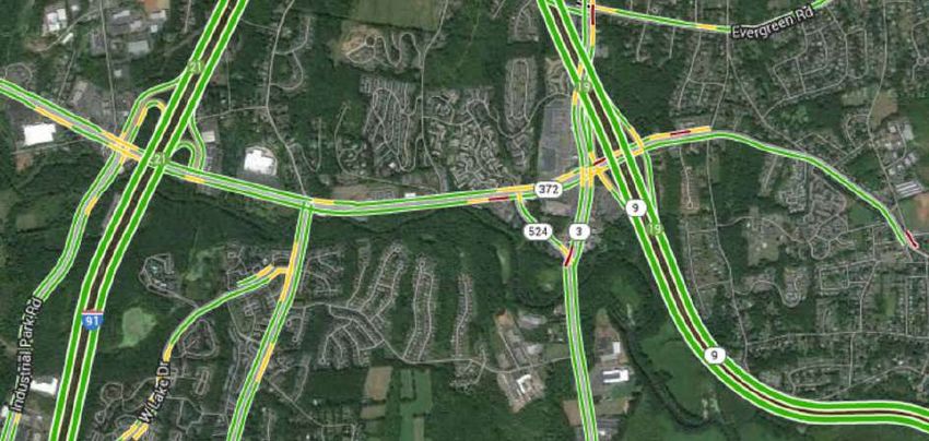
region. North-south routes such as State Routes 9, 17, 81, 154, and 156, and the major east-west
corridor, U.S. Route 1 (Boston Post Road) from Old Lyme to Clinton, experience significant congestion
during the summer with seasonal heavy volume as visitors and residents access the shoreline and
associated state, town and local beaches, summer cottages, and other seasonal attractions.
Frequent accidents on I-95 result in backups on both U.S. Route 1 and I-95. Route 9 in Middletown is
a focal area for continued research and solution based improvements for safety and operability.
State Routes 68, 17, 77, and 79 connecting Middletown to Interstate 91 to New Haven/Hartford and
Interstate 95 and the shoreline consistently experience high year round and seasonal volumes for
commuter traffic. This affects the functionality of the town centers along those routes, specifically
Durham’s town center which is at the apex of Routes 17, 68, 77 and 79. A similar dynamic is located
10RIVERCOG UNIFIED PLANNING WORK PROGRAM (UPWP) FY 2020-2021
in Essex where Route 153, 154, 80, and 9 intersect on a major commuter route. Route 66 on the
east side of the Connecticut River connects East Hampton and Portland town centers and parts of
East Haddam and Haddam with Routes 2 and 9 and Interstate 91. This commuter route has a high
volume of traffic and travel speeds which require consideration for future safety improvements.
As noted in the intermodal section, the need to adapt existing roads to improve intermodal efficiency
(transit, biking, employment, safety) is a primary goal in the region. Incorporating the concept of
“complete streets” on some of the primary collectors in town centers is an important initiative within
the Long-Range Transportation Plan. Optimizing travel modes and land use patterns in each town
center is important for town center economic vitality and livability. Vibrant and accessible town
centers can be easily linked through transit expansion to each other and to employment sectors in
urbanized areas. Road design to accommodate travel speeds and congestion has limiting options:
cost, maintenance, and livability. One goal is to integrate complete street design into local and
regional land use policies. Another target initiative includes planning for efficient use and
maintenance of the existing regional road network in conjunction with rail and transit access and
improved incident management for the portion of Route 9 and I-95 which is within the RiverCOG
region.
The focus for the existing road system is to identify a performance management system for
maintenance and safety improvements that will provide ongoing analysis and data for regional and
CTDOT funding for cost effective road maintenance.
FREIGHT
Freight planning in the region is targeted toward both enhancement of pass through freight via major
arterials such as I-95, I-91, Route 9 and via rail and river. The MPO initiated a partnership with its
neighboring MPOs which resulted in a collaborative venture with CTDOT toward identified methods
to cooperatively create a statewide freight plan since Connecticut is a small state. RiverCOG will
focus on research and analysis to support the statewide freight plan.
In 2015, the Valley Railroad Corridor Freight Analysis examined rail freight movements within the
region in context with this non-utilized corridor to evaluate the benefits derived by upgrading the rail
line to accommodate rail freight traffic and the impact to potential passenger rail, existing tourism
rail, and the general region economy. The region will work in close cooperation and participate in
CTDOT’s data collection to ensure efficiency of data collection efforts. RiverCOG MPO intends to
perform an in-house freight analysis based on the statewide freight plan. Attending workshops on
freight planning and integrating those techniques into the region’s planning is a priority for the
region. Also, the region will be analyzing land use regulations, site plan and road design as well as
bridge height and capacity which can either hinder or expedite movement of freight.
ECONOMIC VITALITY, LAND USE AND ENVIRONMENT
RiverCOG’s transportation planning program incorporates land use, economic, and environmental
scenario planning into all transportation planning within the RiverCOG region and in partnership with
neighboring regions and the CTDOT. To ensure global competitiveness and retention of economic
values and workforce within the region and Connecticut, the region recognizes the integrated
importance of transportation modality and its coordination with land use and environmental
11RIVERCOG UNIFIED PLANNING WORK PROGRAM (UPWP) FY 2020-2021
planning. The functionality of transportation for future land use and environmental scenarios is
critical to the overall economic vitality of the region and the State of Connecticut.
A goal for RiverCOG over the next two years is to more closely examine local and regional planning,
and conservation and development land use policies, to identify best practices for zoning regulations,
climate adaptation, building codes, and public work policies that can work to enhance the viability of
the region’s transportation network. Through RiverCOG’s work with the “Shoreline Basic Needs Task
Force” and other regional housing groups, an important work item in the next two years includes a
regional housing analysis that incorporates study of existing housing stock, opportunities for existing
Brownfields or Greyfields especially along transit corridors. Brownfield or Greyfield land is defined as
economically obsolescent, outdated, failing, moribund or underused real estate assets or land. This
data will be used to update the Regional Plan of Conservation and Development (RPOCD)
Over 2020 and 2021, RiverCOG will continue to incorporate transportation planning into the writing
of RiverCOG’s RPOCD. Additionally, the region’s Land Trust Exchange comprehensive conservation
plan identifies methods for mitigating transportation impacts on wildlife corridors, forest
fragmentation, and water quality. RiverCOG’s wildlife and water resources are a sustainable
economic asset for Connecticut. RiverCOG will provide transportation data and staff support for
implementing recommendations from GrowSmart the region’s Strategic Economic Growth Plan
completed in 2016
TRANSPORTATION SAFETY AND SECURITY
A continuing emphasis within the region is on transportation safety and evacuation preparedness.
This work is done in conjunction with SCCROG to foster advancements in planning for homeland
security concerns and disaster preparedness for DEMHS – Region 2. In addition, RiverCOG continues
to explore options for improved incident management and anticipates the region will create a
regional I-95 incident management team in cooperation with CTDOT to address emergency access,
safety and congestion on Interstate 95 similar to the regional I-91 incident management team.
The overall goal of the region is to incorporate in the Metropolitan Transportation Plan:
Data from the CTDOTs SHSP
Collected data from coordinating RESFs, local services, and state agencies, in a geospatial
format to perform planning analysis for evacuation routing, mitigation, and emergency
response support.
Communication protocol and improvement for transit districts
Crisis management training for transit operators
Coordination to integrate rail, bus, with local transit services, including para-transit
Improved evacuation mapping and dissemination of the information to the public
Evaluate and document those roads and areas which currently need or may require
mitigation of high accident occurrence.
Expand the relationship with traffic authorities in each of the member municipalities and
CTDOT
OTHER TRANSPORTATION MATTERS
12RIVERCOG UNIFIED PLANNING WORK PROGRAM (UPWP) FY 2020-2021
Some of the other matters to be addressed in fiscal years 2020 and 2021 include the following:
refining the implementation of Intelligent Transportation System (ITS) strategies along major
corridors, deployment of incident management strategies for arterials, continued research and
mapping of the most current data to identify and meet environmental justice program needs,
development and maintenance of the regional Transportation Improvement Program (TIP),
coordination as necessary on the State (Air Quality) Implementation Plan, and RiverCOG’s
participation in Congestion Management strategic planning in cooperation with South Central
Regional Council of Governments and Capitol Region Council of Governments. Most important,
sustainable transportation planning is achieved through collaboration, relationships, and
coordination. In addition to its continued affiliation with FHWA, FTA, CTDOT, and other Connecticut
& New England regional planning organizations, RiverCOG will continue to work in partnership with
the Connecticut Aviation Authority, the U.S. Coast Guard, CTDESPP, CTDEEP, CTOPM, U.S Fish and
Wildlife Service, CCAPA, CCM, COST, and other associated state, regional and local entities to
optimize and improve the region and state’s transportation and land use network.
Continuing projects from the include: coordinate the goals of an evolving transportation/tourism
plan to identify transit access for tourism, Connecticut River Heritage Trails Greenway Development,
staff support for the RiverCOG bike/ped committee, coordination with the Valley Railroad, mapping
and analyzing areas at Brownfields or Greyfields near transit stations or stops, upgrades to the
agency website, and a regional complete streets plan. RiverCOG will also provide continuing
assistance to member towns on transportation issues, including access to transportation funding,
freight rail planning, integrated access management, complete streets planning, participation in
regional commuter bikeways, agriculture and natural resource planning, long range transportation
planning, trail development, marine and rail, transportation implications of new regulations or
development, and scenic road designation.
FAST ACT PLANNING GOALS
RiverCOG will continue and expand upon several existing transportation planning activities that
integrate federal requirements under the FAST Act.
Current federal legislation, 23usc134(h)(1) and 49usc5303(h)(1), identifies ten planning factors that
Metropolitan Planning Organizations must consider in their planning process. These planning goals
are identified below.
1. ECONOMIC VITALITY. Support the economic vitality of the metropolitan area, especially by
enabling global competitiveness, productivity, and efficiency.
2. SAFETY. Increase the safety of the transportation system for motorized and non-motorized
users.
13RIVERCOG UNIFIED PLANNING WORK PROGRAM (UPWP) FY 2020-2021
3. SECURITY. Increase the security of the transportation system for motorized and non-motorized
users.
4. MOBILITY. Increase the accessibility and mobility of people and freight.
5. ENVIRONMENT & PLANNING. Protect and enhance the environment, promote energy
conservation, improve the quality of life, and promote consistency between transportation
improvements and State and local planned growth and economic development patterns.
6. SYSTEM INTEGRATION. Enhance the integration and connectivity of the transportation system,
across and between modes, for people and freight.
7. SYSTEM MANAGEMENT. Promote efficient system management and operation.
8. SYSTEM PRESERVATION. Emphasize the preservation of the existing transportation system.
9. RESILIENCY. Improve the resiliency and reliability of the transportation system and reduce or
mitigate stormwater impacts of surface transportation.
10. TRAVEL. Enhance travel and tourism.
In addition, MAP 21 outlined seven national goals, 23usc150(b), and the FAST Act requires MPOs
promote a performance based approach to transportation planning and States must coordinate, to
the maximum extent practical, with relevant MPOs in selecting a target to ensure for consistency.
MPOs must coordinate, to the maximum extent practical, with the relevant States in selecting a
target to ensure consistency. Coordination required with public transportation providers is important
and States and MPOs must integrate other performance plans into the performance‐based process.
The seven goals include:
1) Safety – to achieve a significant reduction in traffic fatalities and serious injuries on all
public roads
2) Infrastructure Condition – to maintain the highway infrastructure asset system in a state
of good repair
3) Congestion Reduction – to achieve a significant reduction in congestion on the National
Highway System
4) System Reliability – to improve the efficiency of the surface transportation system
5) Freight Movement and Economic Vitality – to improve the national freight network,
strengthen the ability of rural communities to access the national and international
trade markets, and support regional economic development
6) Environmental Sustainability – to enhance the performance of the transportation system
while protecting and enhancing the environment
7) Reduced Project Delivery Delays – to reduce project costs, promote jobs and the
economy, and expedite the movement of people and goods by accelerating project
completion through elimination delays in the project development and delivery
process, including reducing regulatory burdens and improving agencies’ work
practices
When RiverCOG completes its Regional Plan of Conservation and Development, it will incorporate
many of the goals and objectives of Metropolitan Transportation Plans and requirements of MAP-21
and the FAST Act. RiverCOG has a history of practice in integrating environmental, economic and
social values, land use and transportation into a regionally planning context for livability. In 2010,
FHWA initiated the INVEST self-evaluation tool, a sustainability working group, and the creation of a
Sustainable Pavements Program, which are among the efforts underway at FHWA to help State and
local agencies document and improve the sustainability of the Nation's roadways. For years, FHWA
has supported research, development, and implementation efforts at the forefront of the
14RIVERCOG UNIFIED PLANNING WORK PROGRAM (UPWP) FY 2020-2021
sustainability movement. The sustainable highways initiative supports the various activities
conducted across FHWA to facilitate balanced decision making among environmental, economic, and
social values to promote sustainability. RiverCOG will continue with the integrated planning method
and more formally utilize the INVEST self-evaluation tool during development of the RiverCOG Plan
of Conservation and Development.
RiverCOG will introduce new recommendations based on current data, research, and best planning
practices into this long range plan for the seventeen town region. To provide a high level of public
outreach and input, a series of meetings to be held during the preparation of the Regional POCD will
incorporate many long range transportation goals and objectives to educate the public and
stakeholders on best management planning for transportation. The Connecticut Strategic Highway
Safety Plan provides a framework for increasing highway safety. Mobility and “Ladders of
Opportunity” for the region’s population are another ongoing practice for RiverCOG and a key goal of
any transportation solution promoted by RiverCOG. The region continues to find ways to provide
intermodal access to key service and education sectors for advancement and opportunity. RiverCOG
is also partnered with SCCROG in the effective use and support of regional “Mobility Manager”
program to identify gaps in transit service for underserved and disadvantaged populations.
The proposed work program elements respond to the planning goals noted above. In addition, the
MPO will also incorporate the tasks below, performance base planning, strategic economic growth
and vitality, modeling of existing and future land use scenarios and environmental planning with
transportation models, continued advocacy for safety improvements, security and integration of all
transportation modes.
TRANSPORTATION PLANNING & INTEGRATION OF FAST ACT OBJECTIVES
Task 1: Management of the Transportation Planning Process
Staff & Task Management: RiverCOG will manage staff and program resources in a manner
appropriate to ensure all tasks in the work program are completed in accordance with the work task
descriptions contained in the UPWP, in accordance with FHWA and FTA regulations, and in
accordance with any third party contracts executed by RiverCOG. RiverCOG will also assure that
proper reports on program progress and financial status are provided to all funding agencies.
Budgeting: RiverCOG has established fiscal and management procedures to integrate RiverCOG’s
UPWP activity into RiverCOG’s overall budget, accounting and program processes.
Audits: RiverCOG engages an independent Certified Public Accountant to prepare an annual audit. It
is delivered to CTDOT for its review and approval. This audit shall be performed in accordance with
OMB Circular A-128, Audits of State and Local Governments. MPO Certification Review: RiverCOG
15RIVERCOG UNIFIED PLANNING WORK PROGRAM (UPWP) FY 2020-2021
will continue to modify the work programs and deliverables to maintain positive conclusions and
recommended practices and deliverables as listed in MPO certification reviews.
Anticipated Dates for Completion of Products (unless labeled as ongoing) is noted in the timeline
PRODUCTS TIMELINE
1. Unified Planning Work Program MAY 2021
2. DOT-RiverCOG Agreement JUNE 2021
3. Quarterly program progress reports ONGOING
(Including Title VI activity report)
4. Audit reports for FHWA, FTA, and CTDOT
funded projects. ONGOING
5. Updates to information and data for
Environmental Justice and Title VI ONGOING
6. Coordinate and work on cooperative planning structure
with New Haven and Hartford TMA to streamline CTDOT
capital planning and project coordination. ONGOING
7. Approve new Affirmative Action Plan 1st QTR FY 2020
8. Implement and periodically review Affirmative Action Plan ONGOING
TASK 2: DATA COLLECTION/ANALYSIS
A. General Collection and Analysis
Develop and maintain demographic and transportation databases and migration into a regional
database for travel forecast models, congestion management, air quality and other associated
federal requirements. RiverCOG, in cooperation with neighboring MPOs, the transit districts, and
consultants, will assist CTDOT in the updating of data bases. This includes maintenance,
improvement, and expansion of a regional geographic information system to support other
transportation planning activities. Maintain other transportation data that supports transportation
planning activities of RiverCOG and other agencies including, but not limited to; the Estuary Transit
District, Middletown Transit District, SCRCOG, SCCOG, CRCOG, and the Chambers of Commerce.
Mapping as referenced in this document includes: creation and updates to geospatial database and
fields for specific information as well as representative maps for planning documents and depiction
of information. Data collected is used to promote consistency of the MTP and proposed
transportation programs and improvements with state and local development patterns.
MAJOR ACTIVITIES FOR FY 2020/2021
• Finalize the Regional Performance Incentive Project (CTOPM Grant) and develop a sole
source regional GIS system from the two former MPOs/RPAs. This includes finalizing and
refining CAMA and parcel data. This includes seeking out geospatial information from state
agencies to ensure that up-to-date geospatial data is available for planning purposes.
• Continued update of current demographic analysis for region transportation objectives,
economic growth forecasting, land use analysis and methods for forecasting growth in
16RIVERCOG UNIFIED PLANNING WORK PROGRAM (UPWP) FY 2020-2021
population, households, and employment by town for underserved populations as well as
general population.
• Research and analyze data as a comprehensive update to RiverCOG’s Metropolitan
Transportation Plan (MTP) and Transportation Improvement Program (TIP).
• Develop land use forecasting methods for the River region. Develop improved methods for
allocating forecasted growth in population, households, and employment, including possible
build out analysis for region.
• Identify and map areas for transit oriented housing, specifically opportunities for affordable
housing. This also includes Brownfield or Grayfield areas that could potentially be reclaimed
for housing near rail stations or bus stops.
• Other Data. Collect other data for CTDOT and others as needed. (example: HPMS, 536
Report, commuter lot counts, bridge data, accident locations, traffic counts)
• Review and update new geospatial data base for regional bridges and overpasses (height –
weight –width) and road ROW restrictions.
• Monitor and mapping of maritime traffic database for lower Connecticut River and shoreline
towns as needed for harbor management planning and marinas.
• Mapping and monitoring of invasive species in navigable waters.
• Mapping and analysis of forestation and natural resources.
• Collection of data for stormwater management as it relates to regional highway and roads.
• Analysis of road data and transit data for the regional Bicycle-Pedestrian Plan, Bike/ped
projects, corridor studies and the Transit Integration Study.
• Collection and analysis of freight data and stakeholders.
• Create a database and mapping for regional trail system including intermodal connection
with existing transportation systems.
• Mapping and data collection for underserved populations, health and assistance service
centers, foodbanks, agriculture commodities and distribution.
• Mapping and analysis of economic data, business sectors, freight distribution, and small
business locations.
• Develop a geospatial database and map tourism within the region
Anticipated Dates for Completion of Products (unless labeled as ongoing) is noted in the timeline
PRODUCTS TIMELINE
1. Maintenance and updates to(GIS) Parcel
and Database for the River region. ONGOING
2. Continue updates of website with current data
and maps ONGOING
3. Integrate MTP update into Regional Plan
of Conservation & Development ONGOING
4. Update regional demographic database ONGOING
5. Bicycle and pedestrian data support to member
towns as required ONGOING
6. Trail mapping and database for intermodal
connection with existing transportation modes ONGOING
8. Monitor maritime traffic database
including CT River Ferry statistics ONGOING
17RIVERCOG UNIFIED PLANNING WORK PROGRAM (UPWP) FY 2020-2021
9. Work with CTDOT on data for STP, LOTCIP, TIP/STIP,
ACQ determinations, capital planning, etc. ONGOING
10. Monitor and mapping of invasive species ONGOING
11. Data collection associated with development of
MTP update ONGOING
12. Mapping and data collection – regional housing, soils
Greyfields, Brownfields, and utility infrastructure ONGOING
13. Transit operations analysis and data collection ONGOING
14. Regional roads condition survey and database ONGOING
15. Create and maintain geospatial database
EJ – Title VI populations and associated services ONGOING
16. Create geospatial database for economic and
agriculture business in the region and map ONGOING
17. Develop a geospatial database and map tourism
assets within the region ONGOING
B. Traffic, Congestion and Safety Management
OBJECTIVES
To implement traffic congestion management and increased safety within the RiverCOG region for
traffic which is caused or influenced by traffic congestion out from New Haven, Hartford and other
urbanized areas for commuters and/or from seasonal increases. By cooperating with the New Haven
and Hartford MPOs, and in the coordination of congestion management within the New Haven
Transportation Management Area and the Hartford TMA, this larger regional area should be able to
make significant inroads into congestion management and traffic safety. RiverCOG, in cooperation
with its DEMHS and regional partners and transit districts, will also work on transportation planning
for emergency response in coordination with the other COGs, DEMHS, and CTDOT to move toward
increased mobility and coordination during a regional or statewide incident, emergency, or
catastrophic event.
MAJOR ACTIVITIES FOR FY 2020/2021
* Analyze and compile information on existing congestion and safety management
* Evaluate and participate in municipal committees to analyze identified traffic intersection of
significance for congestion and safety concerns on state and local roads.
* Research improved method for traffic counts and purchase as needed.
* Research emerging travel demand methodologies and implement.
* Provide lead coordination on implementation of Route 1 Corridor Study recommendations.
* Provide lead coordination on implementation of Route 81 Corridor Study recommendations
* Provide lead coordination on implementation of Route 66 Corridor Study recommendations
* Provide lead coordination on implementation of Transit Integration Study recommendations
* Continue to staff and support inter-agency and municipal coordination for improvements for
congestion on Route 9.
* Monitor inter-regional traffic and congestion. Monitor and evaluate transportation system
performance for regional land use changes within context of updated regional and local land
18RIVERCOG UNIFIED PLANNING WORK PROGRAM (UPWP) FY 2020-2021
use plans to better evaluate influences on traffic congestion and access within the region.
The system will include: the freeway system, the arterial system, and the local road system.
* Coordinate with CTDOT on planning efforts for on-going incident management activities, and
ITS planning
* Coordinate with CTDOT on development of regional goals for transportation system and
performance measures
* Coordinate with CTDOT on the development of a regional transportation safety plan
* Coordinate with South Central Council of Governments and Capitol Region Council of
Governments for projects and data collection in the areas of transit, Congestion
Management Process (CMP) and Air Quality Conformity, and Safety/Operations/
Management Strategies
Determine the CMP network in the region: highway and transit
Define regional congestion in context with State CMP: both the parameters to be
measured and thresholds
Identify congested links: using CTDOT CMS report and collected data
Develop strategies to address congested link: geometric, operational and travel
demand related
Implement short and long term strategies through the MTP and TIP process
Monitor, collect and assess data to determine improvements
Share traffic data with CTDOTs traffic analysis unit
* Identify and map areas where traffic congestion and speed is a problem on local roads and
intersections for vehicles but also bicyclists, and pedestrians
* Continue process of identifying thresholds on major arterials for CMP for medium to major
traffic generators.
* Work with other COGs/CTDOT on implementation of the Statewide Bicycle Plan
* Work with other COGs/CTDOT on implementation of the Statewide Freight Plan
* Collect data on river usage and conditions for use including, freight, ferry traffic, recreational
tourism, recreational boaters, and dockage
* Analysis of existing traffic and commuting patterns intra-region for regional planning and
regulatory land use analysis.
* Assist in coordination where appropriate with CTDOT on statewide CMP
* Continued planning for rail parking improvements and transit options for commuters for
future TOD land use in the region
* Work with the DEMHS Region 2 Regional Emergency Planning Team (REPT) to plan for
coordination and response for transportation support in the event of a regional or statewide
emergency.
Anticipated Dates for Completion of Products (unless labeled as ongoing) is noted in the timeline
PRODUCTS TIMELINE
1. Report on region traffic monitoring and system for
coordination with land use and development best practice ONGOING
2. Assist SCRCOG, CRCOG and CTDOT with Congestion
Management Process ONGOING
3. Traffic count mapping for local roads within seventeen towns
and provide to CTDOT as completed ONGOING
4. Updated commuter lot counts within region ONGOING
19You can also read