August 2021 - Belmont Resources
←
→
Page content transcription
If your browser does not render page correctly, please read the page content below
August 2021
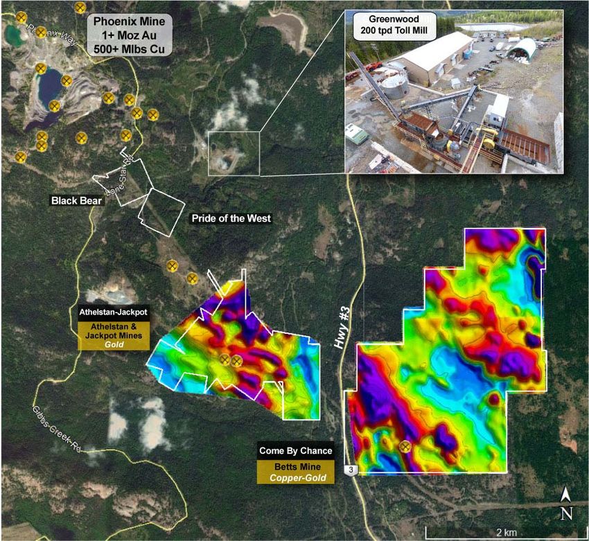
In the last year Belmont has acquired no less that 6
   past producing mines.
– Pathfinder, B.C. – *Bertha & Pathfinder Gold–Silver mines
– Come By Chance (CBC), B.C. – *Betts Copper‐Gold mine
– Athelstan‐Jackpot (A‐J), B.C. – *Athelstan & Jackpot Gold mines
– Lone Star, Washington – *Copper‐Gold mine
* past producing mine

Acquiring and re‐developing past producing copper‐gold‐silver
mines in southern British Columbia and Northern Washington
State, which is considered to have the highest concentration of
mineralization and past producing mines in western North
America. By utilizing new exploration technology, geological
modelling and 3D data analysis, the company is identifying new
areas of mineralization beneath and/or in the near vicinity of the
past producing mines.
Acquiring past producing mines
       in one of the most prolific
mining camps of western North America

                                    • The prolific Greenwood mining camp
                                      of southern British Columbia and the
                                      adjacent Republic camp of
                                      Washington state, have a rich history
                                      of mining. It is considered to be one
                                      of the most concentrated mineralized
                                      areas in western North America

                                    • Between the two mining camps, over
                                      5 million ounces of gold was
                                      produced.

                                                                              2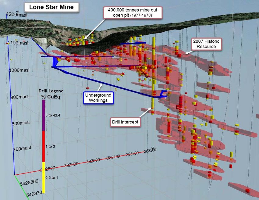
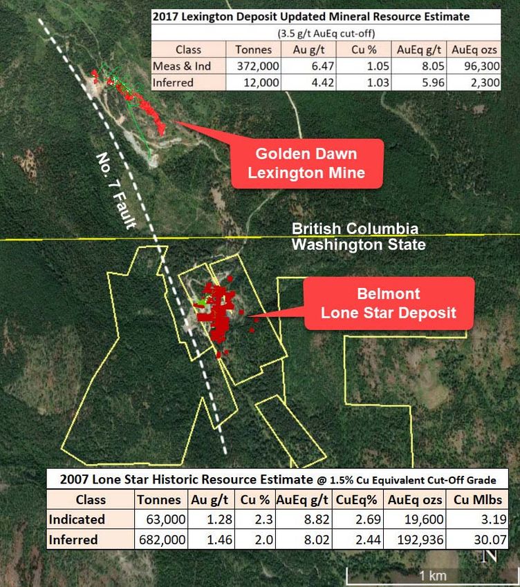
Lone Star Mine

•   The Lone Star property is located in northern Washington
    State on the northeastern tip of the Republic Graben, an
    important geological feature which hosts several gold and
    copper mines.
•   The property lies on a 3‐kilometer long trend of gold‐
    copper mineralization linked by geology, in both rock
    types and structure, as well as the accompanying gold‐
    copper mineralization.

•   The geology and mineralization of the Lone Star Property
    is strongly influenced by the 600 meter wide No. 7 Fault

•   Golden Dawn’s Lexington Property lies adjacent to the
    Lone Star property on the Canadian side.

•   Although no metallurgical test work has been done on
    the Lone Star mineralization, its metallurgical response is
    expected to be similar to the Lexington ore which has
    been successfully processed at the Greenwood Mill 7km
    to the north.

                                                                                   4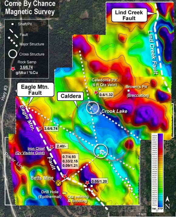
Lone Star Mine

 • High grade copper‐gold historic resource estimate*

  The 2007 historic resource estimation was based on US$593/oz gold and
  US$2.84/lb copper.

• The Lone Star mine operated over two time periods;
  underground from 1897‐1918 producing 146,540 tonnes, and
  open‐pit from 1977‐1978 by Granby Mining Co. when 400,000
  tonnes of ore were transported from the Lone Star open pit to
  its Phoenix mill in B.C, 11km to the north.

  Many Lone Star drill intercepts demonstrate underground
  mine widths and grade.

                                                                          *“Technical Report and Resource Estimate on the Lone Star Deposit, Ferry
                                                                          County Washington (September 23, 2007)” for Merit Mining Corp. and
                                                                          authored by P&E Mining Consultants Inc.

                                                                          NI 43‐101 Disclosure:
                                                                          A qualified person has not done sufficient work to classify the historic
                                                                          estimate as current mineral resources or mineral reserves. As such the issuer,
                                                                          Belmont Resources, is not treating this historical estimate as current mineral
                                                                          resources or mineral reserves.

                                                                                                                                                      5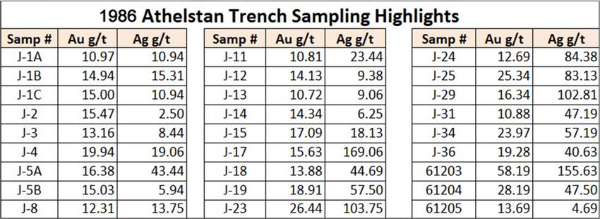
Lone Star Mine – Moving Forward
The 2007 43‐101 Technical Report by P&E Mining Consultants prepared
for Merit Mining Corp, the previous owner suggests:

“the Lone Star deposit resource estimate can be used in a Preliminary
Assessment or Scoping Study. Feasibility studies that require a
component of Measured Resources will necessitate additional programs
of infill drilling and closer spaced drilling in representative regions of the
deposit.

“the property has potential for additional resources as many zones in the
deposit remain open and untested to fully define their extent. The areas
with the most potential to expand the resource are located in the
southern and eastern portions of the deposit and at depth below the pit
outline.”

Drilling Planned
Belmont is planning a 3,000 metre drill program, in 15 holes, proposed
with 5 holes for infill drilling, 7 holes testing outward from the southern
cluster of thick high‐grade zones, and 3 holes to test the expansion of an
eastern thick, rich zone.

With the objective of:
1. Adding additional resources
2. Bringing the historic resource to current 43‐101 requirements
3. Moving a component of inferred resource to measured resource in
preparation for Preliminary Assessment, Scoping and Feasibility studies.

                                                                                   6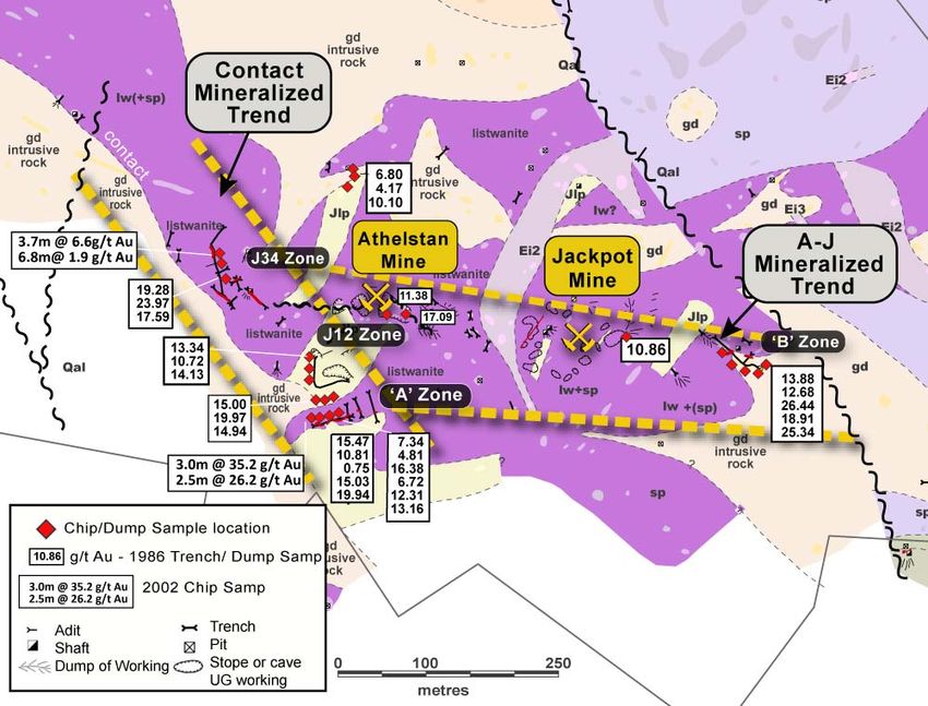
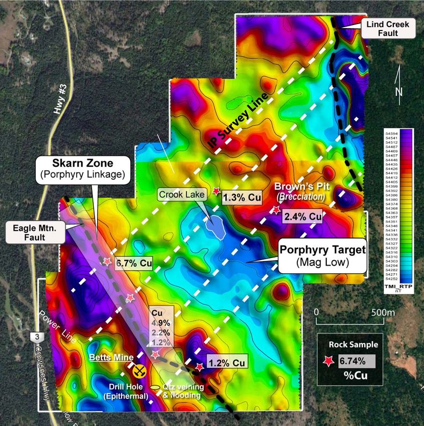
Come By Chance (CBC) Property
                                        Large Copper/Gold Porphyry Deposit Target

• Review of historic exploration
 revealed many indications to a
 potential concealed intrusive of
 copper/gold mineralization at the
 “Betts Mine” in the skarns, the free
 gold, the epithermal zone intersected
 in a drill hole, and the intersection of
 a massive sulfide epithermal
 indicated, zone in the 251 metre Betts
 tunnel.

                                                                           Magnetic Survey

                                                                                             7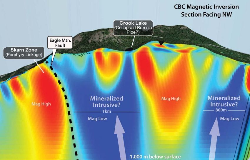
Come By Chance Property
                                      LIDAR Survey Reveals Important Structures

        Belmont 2020 LIDAR Survey
      Supports Large Porphyry Model
• Lidar surveys virtually remove surface vegetation and
   bare earth. By doing so geologist are able to see
   apparent structure which may control mineralization

• The location of an intrusive is supported by the results
   from the Lidar survey which clearly showed a series of
   radiating faults from the lake and obscure ringed
   faults surrounding the lake.                                                   LIDAR
                                                                                  Survey
• These faults were likely developed from a rising
   intrusive and were instrumental as the means of
   mineral laden hydrothermal fluid transport from the
   intrusive to create the localized skarns.

• The largest area of mineralization on the Property, the
   Betts copper/gold Betts skarn area may have
   developed from the same hydrothermal fluids that
   caused the heterolithic breccia alteration of the Eagle
   Mountain Fault.

                                                                                           8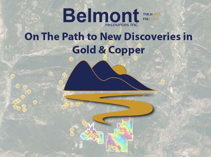
Come By Chance Property
                                         Magnetic Reveals Classic Porphyritic Signature

Belmont 2020 Low Level, Hi Res Mag Survey
  Further Supports Large Porphyry Model
• The detailed, low‐level magnetic survey has provided
   a greater indication of the volcanic caldera that was
   initially indicated by the recently completed Lidar
   survey.

• The indicated Caldera is supported by a one kilometre
   diameter magnetic low. Two cross‐structural locations
   within the indicated caldera and the magnetic low, are
                                                                                          LIDAR
   of greater significance.                                                               Survey

• In the north, the small circular Crook Lake, with a
   highly anomalous arsenic and correlative with a cross‐
   structure, may be the most obvious indication of a
   hydrothermal or collapsed breccia zone.

• In the south, one of the three structures formulating
   the cross‐structure, is a southerly trending structure
   correlating with a magnetic low. This location would
   be highest priority exploration area.
        CBC Property mag survey results showing composite
            interpretation of the Lidar and mag surveys
  showing the indicated caldera and a potential concealed intrusive

                                                                                                   9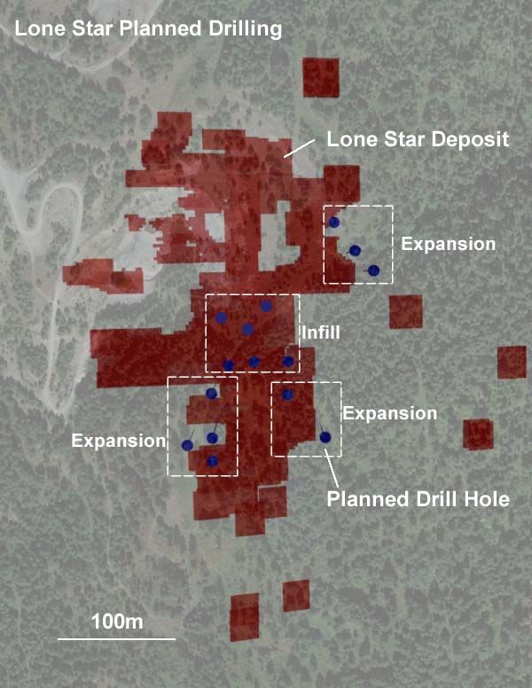
Come By Chance Property
                                    Large Copper/Gold Porphyry Deposit Target
                          CBC magnetic 3D inversion model cross‐section looking north

                                                                       Possible
                                                                       Drill Hole

A cross section of the magnetic inversion 3D model reveals possible two separate “Hydrothermal Intrusive Systems
(blue)” The two systems may be joined a depth.

The section also reveals the know skarn zone at the Eagle Mtn Fault, which appears to be linked to the intrusive
porphyry. This is a classic “Porphyry‐Skarn Linkage” scenario.

                                                                                                                   10
Come By Chance Property
Moving Forward
Planned IP Survey & Drilling
• The Company is planning for a 4 line (12 line kms)
IP survey. The survey will help delineate key drill
targets
• This will be followed by a drill program. The drill
hole locations and the amount of meters to be
drilled will be determined once the Company
receives and reviews the results from the IP
survey.
• The IP survey has been delayed due to severe
fires restrictions in the area. It is hoped that the
survey will continue in mid September.
11The A‐J Gold Project
Athelstan & Jackpot Gold Mines
Low Grade Near Surface Bulk Tonnage Gold Prospect
• Property contains Athelstan and Jackpot
past producing gold mines.
• Production: 7,600 ozs Au & 9,000 oz Ag
(Minfile 082ESE047).
• Excellent infrastructure with power,
water and highway access.
• Easy road access only 10kms from the
city of Grand Forks by way of Highway #3
• Only 1.5kms to 200 tpd toll mill.
• Along with the numerous mineralized
pits the property contains extensive
mine dumps that contain further
mineralization.
• The strike extent of the A‐J gold bearing
structure is over 1 kilometre
12The A‐J Gold Project
Extensive Surface Gold
Mineralization
Belmont is investigating the potential for
surface and near surface ore zones with
economic gold grades.
A further possible source of ore at the
surface may be the extensive mine
dumps that appear to contain ore grade
material. (Arrowhead Resources Surface
Dump Sampling report, Grant 1981)
In the report Grant states “A potential
resource of 2,000‐5,000 ounces of gold in
the surface and near surface mineralized
areas appears to exist within the A‐J
Group base on previous trenching results
and sampling of mine dumps.”
13The A‐J Gold Project
Trench and Mine Dump Sampling Highlights
Dr. Robert Grant 1978 dump samples
14The A‐J Gold Project
Moving Forward
Mine Dumps:
• The Company plans to map the
extensive mine dumps.
• Measure and estimate volumes
• Extensive testing with XRF hand held
geochemical analyzer for quick assay
results.
Prepare bulk sample for processing at
nearby Mills ie (Merrit Mill, Greenwood
Mill)
Potential Mining?
• Investigate areas of near surface high
grade gold sampling for potential of
bulk sampling and eventual mining.
• Extensive testing with XRF hand held
geochemical analyzer for quick assay
results.Key Facts
Share Info
As of July 31, 2021
Shares O/S: 43,369,772
Warrants O/S: 26,791,752
Options O/S: 2,670,000
Fully Diluted: 77,831,524
Contact Info
Belmont Resources Inc.– TSX‐V: BEA
Suite 615 – 800 W. Pender Street
Vancouver, British Columbia,
Canada V6C 2V6
Telephone: (604) 505‐4061
E‐mail: george@belmontresources.com
16Cautionary Statement
Except for historical information contained herein, this presentation may contain forward‐looking statements
including, but not limited to, comments regarding predictions and projections. Forward‐looking statements
address future events and conditions and therefore involve inherent risks and uncertainties. Although Belmont
Resources believes that such expectations are reasonable, there can be no assurance that such expectations
will prove to be correct, and therefore actual results may differ materially from those currently anticipated in
such statements. You are cautioned not to place reliance on such forward‐looking statements, whether made
in this presentation or in any question and answer period related to this presentation.
Qualified Persons
Laurence Sookochoff, P.Eng. is a Qualified Person as defined by NI 43‐101 and approved the technical
information in this document.
1You can also read