Assessment of the Conservation Status of the Great Island Channel SAC (001058)
←
→
Page content transcription
If your browser does not render page correctly, please read the page content below

Assessment of the
        Conservation Status of the
         Great Island Channel SAC
                         (001058)

                                                  June 2014

F.H. O'NEILL, J.T. BROPHY, F.M. DEVANEY, R. NASH & S.J. BARRON
DOCUMENT CONTROL SHEET
Client                    Cork County Council

Project title             Assessment of the Conservation Status of the Great Island
                          Channel SAC (001058)

Project number            PRJ95

Document title            Assessment of the Conservation Status of the Great Island
                          Channel SAC (001058)

Citation                  O’Neill, F.H., Brophy, J.T., Devaney, F.M., Nash, R. & Barron, S.J.
                          (2014) Assessment of the Conservation Status of the Great Island
                          Channel SAC (001058). Report for Cork County Council.

Author(s)          Reviewed by      Approved by      Version              Issue date
FON,JB,FD,RN,SB    SB               SB               v1.0 Draft           20/06/2014
FON,JB,FD,RN,SB    SB               SB               v1.1 Draft           25/06/2014
FON,JB,FD,RN,SB    SB               SB               v1.0 Final           27/06/2014
FON,JB,FD,RN,SB    SB               SB               v1.1 Final           09/07/2014
Assessment of the Conservation Status of the
Great Island Channel SAC (001058)
Report for
Cork County Council
June 2014
F.H. O’Neill, J.T. Brophy, F.M. Devaney, R. Nash & S.J. Barron
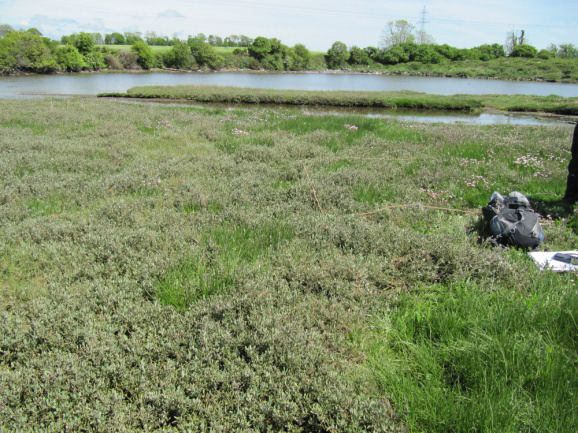
Saltmarsh creek at Fota, Carrigtohill.
Photo © BEC Consultants.
Botanical, Environmental & Conservation Consultants Ltd.
Ground Floor Offices, Loft 31, South Cumberland St., Dublin 2.
Tel: 01 6619713
Website: www.botanicalenvironmental.com
Email: info@botanicalenvironmental.com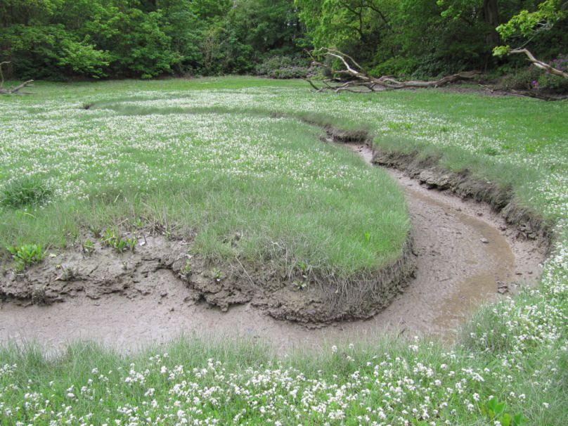
PRJ95 – Assessment of the Conservation Status of the Great Island Channel SAC

                                                           Table of Contents

1     Introduction ..................................................................................................................................... 1
    1.1      Rationale for the survey .......................................................................................................... 1
    1.2      Features of interest in Great Island Channel SAC .................................................................. 1
    1.3      Description of Qualifying Interests (Annex I habitats) in the SAC ........................................... 2
      1.3.1         Characteristics of 1140 Mudflats and sandflats, and main pressures ............................ 2
      1.3.2         Characteristics of 1330 Atlantic salt meadows, and main pressures .............................. 2
    1.4      Conservation assessment of Annex I habitats ........................................................................ 3
2     Methods .......................................................................................................................................... 4
    2.1      1140 Mudflats and sandflats ................................................................................................... 4
      2.1.1         Area (Extent) assessment ............................................................................................... 4
      2.1.2         Structure and functions assessment ............................................................................... 4
      2.1.3         Future prospects (Impacts) assessment ......................................................................... 5
    2.2      1330 Atlantic salt meadows .................................................................................................... 5
      2.2.1         Area (Extent) assessment ............................................................................................... 5
      2.2.2         Structure and functions assessment ............................................................................... 5
      2.2.3         Future prospects (Impacts) assessment ......................................................................... 6
3     Results ............................................................................................................................................ 6
    3.1      1140 Mudflats and sandflats ................................................................................................... 6
      3.1.1         Description of sample areas ............................................................................................ 6
      3.1.2         Area (Extent) assessment ............................................................................................. 10
      3.1.3         Structure and functions assessment ............................................................................. 10
      3.1.4         Future prospects (Impacts) assessment ....................................................................... 12
      3.1.5         Overall condition assessment ....................................................................................... 13
    3.2      1330 Atlantic salt meadows .................................................................................................. 13
      3.2.1         General description of areas surveyed ......................................................................... 13
      3.2.2         Area (Extent) assessment ............................................................................................. 16
      3.2.3         Structure and functions assessment ............................................................................. 16
      3.2.4         Future prospects (Impacts) assessment ....................................................................... 18
      3.2.5         Overall condition assessment ....................................................................................... 19
4     Discussion .................................................................................................................................... 19
    4.1      Site-specific conservation objectives and targets for the SAC ............................................. 19
    4.2      Water quality issues in Great Island Channel SAC............................................................... 20
    4.3      Annex I saltmarsh habitats in Great Island Channel SAC .................................................... 21
    4.4      Management changes required to restore favourable conservation status .......................... 22
      4.4.1         Water quality ................................................................................................................. 22
      4.4.2         Spartina management ................................................................................................... 23
      4.4.3         Increasing the area of Annex I 1330 Atlantic salt meadows ......................................... 24
      4.4.4         Monitoring ...................................................................................................................... 25
    4.5      Prospects for recovery of features of interest ....................................................................... 25

BEC Consultants Ltd – June 2014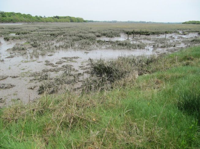
PRJ95 – Assessment of the Conservation Status of the Great Island Channel SAC

5     Conclusions .................................................................................................................................. 26
    5.1     1140 Mudflats and sandflats ................................................................................................. 26
    5.2     1330 Atlantic salt meadows .................................................................................................. 26
6     References ................................................................................................................................... 26

Map 1: Transect and sample locations.
Map 2: Location of saltmarsh sites surveyed.
Map 3: Carrigtohill.
Map 4: Bawnard.
Map 5: Lough Atalia.
Map 6: Harpers Island.
Map 7: Slatty Bridge.
Map 8: Belvelly.
Map 9: Rossmore.
Map 10: Midleton.

Appendix I: Biotopes.
Appendix II: Relevé (assessment stop) data.
Appendix III: Scientific/English names of plants recorded.
Appendix IV: Plates.

BEC Consultants Ltd – June 2014
PRJ95 – Assessment of the Conservation Status of the Great Island Channel SAC

1     Introduction

1.1     Rationale for the survey

Cork County Council appointed BEC Consultants Ltd. to conduct surveys on the Qualifying Interests
of the Great Island Channel Special Area of Conservation (SAC) (site code 001058). The objective of
these surveys was to determine the current conservation status of these features, and to assess the
likely impacts on the SAC of increased waste water loadings generated by the 2022 population
targets given in the draft Cork County Development Plan 2013.
A number of surveys of the area had previously been carried out. Intertidal surveys for the Annex I
                                                                       1
habitat 1140 Mudflats and sandflats not covered by seawater at low tide were conducted in the Great
Island Channel SAC in 2006 and 2011 by Aquafact and MERC respectively (Aquafact, 2006; MERC,
2012), and a subtidal survey, as part of a Water Framework Directive (WFD) assessment, was carried
out by EcoServe on behalf of the Marine Institute in 2011. These data were used to determine the
physical and biological characteristics of the SAC and overlapping areas of Cork Harbour Special
Protection Area for birds (SPA) (NPWS, 2014a). Surveys of the Annex I habitat 1330 Atlantic salt
                                               2
meadows (Glauco-Puccinellietalia maritimae) in the SAC were conducted as part of the Saltmarsh
Monitoring Project (SMP) by McCorry & Ryle (2009). Further surveys, incorporating both aerial
photograph interpretation and field surveys, were carried out by Atkins as part of the Blarney and
Midleton Electoral Districts Habitat Surveys (O’Donoghue, 2008; O’Donoghue et al., 2009).
The field work carried out for the current project augments and updates the data collected during the
previous surveys noted above and allows comparisons to be made.

1.2     Features of interest in Great Island Channel SAC

According to the Natura2000 viewer website (http://natura2000.eea.europa.eu), the Great Island
Channel SAC covers an area of 1,443.22 ha. The website lists four Annex I habitats for the site: 1140
Mudflats and sandflats, 1330 Atlantic salt meadows, 1130 Estuaries and 1320 Spartina swards
(Spartinion maritimae). However, the latter two Annex I habitats are listed in the Natura2000 website
with a representativity of “D” (non-significant presence”), and 1320 Spartina swards (Spartinion
maritimae) is now thought to be absent from Ireland (NPWS, 2013).
Therefore the latest site-specific conservation objectives available for the SAC from National Parks
and Wildlife Service (www.npws.ie), dated June 2014, list only two Annex I habitats as Qualifying
Interests for the site: 1140 Mudflats and sandflats, and 1330 Atlantic salt meadows. Of these, by far
the more abundant is 1140 Mudflats and sandflats, which covers 894.79 ha, or 62% of the SAC area,
while 1330 Atlantic salt meadows covers 28.86 ha, or just 2% of the SAC area
(http://natura2000.eea.europa.eu). Only these two Annex I habitats, listed as Qualifying Interests for
the SAC, are assessed in the current report.
Other Annex I habitats which are not listed on the Natura2000 website are also present in the SAC.
For example, McCorry & Ryle (2009) recorded 1310 Salicornia and other annuals colonising mud and
     3
sand , and the National Survey of Native Woodlands recorded wet woodland at Belvelly which is
referable to the priority Annex I habitat *91E0 Alluvial forests with Alnus glutinosa and Fraxinus
excelsior (Alno-Padion, Alnion incanae, Salicion albae) (Perrin et al., 2008; NPWS, 2013).
Great Island Channel SAC overlaps with Cork Harbour SPA, which is an internationally important
wetland site supporting large populations of wildfowl, in particular wintering waterbirds. It also

1
  Referred to hereafter as 1130 Mudflats and sandflats
2
  Referred to hereafter as 1330 Atlantic salt meadows
3
  Referred to hereafter as 1310 Salicornia mud

BEC Consultants Ltd – June 2014                                                                    1
PRJ95 – Assessment of the Conservation Status of the Great Island Channel SAC

supports a nationally important breeding colony of Common Tern (Sterna hirundo). The mudflats
within the SAC support macroinvertebrates that are an important food source for the birds, and the
saltmarshes provide high tide roosts.

1.3     Description of Qualifying Interests (Annex I habitats) in the SAC

1.3.1    Characteristics of 1140 Mudflats and sandflats, and main pressures
NPWS (2013) describes this habitat in detail, and the following description is summarised from that
publication.
This habitat is found exclusively between the low water and mean high water marks, and is often a
subset of the Annex I habitats 1160 Large shallow inlets and bays and 1130 Estuaries. The habitat is
fundamentally composed of sediment ranging from 1 µm to 2 mm, the finer silt and clay sediments
being dominant in mudflats and the larger sand fractions associated with areas exposed to significant
wave energy. Close packing of small sediment particles may lead to low oxygen levels in underlying
sediments due to minimal exchange of water.
The biological communities found in 1140 Mudflats and sandflats include invertebrates such as
polychaete worms and bivalves. As noted above, the habitat forms an important feeding resource for
birds, particularly the wildfowl that use it for overwintering.
Natural physical pressures operating on the habitat include fluctuations in salinity, temperature and
immersion, while the main anthropogenic pressures identified at a national level include pollution,
fishing and harvesting aquatic resources, bottom culture and suspension culture.
Not mentioned in NPWS (2013) is the issue of invasion by the non-native cord-grass (Spartina anglica
and hybrids; hereafter called Spartina). This was seen during the current survey to be forming
extensive swards in parts of the Great Island Channel SAC, most notably in Belvelly Channel.

1.3.2    Characteristics of 1330 Atlantic salt meadows, and main pressures
McCorry & Ryle (2009) give the following description of saltmarshes. Saltmarshes are wetland areas
that are found in sheltered coastal areas such as in estuaries, and contain vegetation communities
that have generally developed on soft mud or muddy sediments deposited by the sea. Saltmarsh is
generally restricted to the area between mid-neap tide level and high water spring tide level. Fossitt
(2000) describes two types of saltmarsh, CM1 Lower saltmarsh, and CM2 Upper saltmarsh. Lower
saltmarsh may be covered by the tide twice a day, while the upper marsh may only be covered by
higher tides (spring tides) several times each month (McCorry & Ryle, 2009). Zonation of vegetation
develops in response to the gradient of the saltmarsh, which affects salinity and frequency of
inundation, and at the landward side there are also generally transitional communities formed with
other terrestrial habitats such as grassland, reed swamp and dunes.
The Annex I saltmarsh habitat 1330 Atlantic salt meadows may occur either on lower saltmarsh or
upper saltmarsh. Throughout this report, classification of saltmarsh habitats is according to Fossitt
(2000), and of Annex I saltmarsh is according to the CEC (2013) interpretation manual for Annex I
habitats, with further definition and interpretation of Annex I saltmarsh habitats in an Irish context
being made with reference to McCorry & Ryle (2009). Ongoing work by Perrin et al. (in prep.) has
involved the analysis of saltmarsh relevés by fuzzy analysis, and additional resolution of saltmarsh
vegetation communities has been provided by the application of their preliminary classification, in
which two communities of Annex I 1330 Atlantic salt meadows vegetation have been identified, one
from each of the Puccinellion maritimae and the Armerion maritimae alliances. These will hereafter
be referred to as the Puccinellion-type and Armerion-type communities.

BEC Consultants Ltd – June 2014                                                                    2
PRJ95 – Assessment of the Conservation Status of the Great Island Channel SAC

The main pressures operating on 1330 Atlantic salt meadows at a national level, according to NPWS
(2013) and based largely on the work of McCorry & Ryle (2009), are intensive cattle and sheep
grazing, erosion, invasive non-native species (Spartina), and paths, tracks and cycling tracks.

1.4    Conservation assessment of Annex I habitats

The national conservation assessment of Annex I habitats is carried out according to guidelines
published by the EU (Evans & Arvela, 2011). It utilises four main parameters to assess the habitats:
range, area (extent), structure and functions, and future prospects.
Assessment of area is concerned with detecting changes in the extent of the Annex I habitat over
time, particularly habitat losses. The actual parameter measured is percent annual change for the
period over which the change is being assessed.
The structure and functions assessment examines a number of criteria that measure the health and
overall functioning of the Annex I habitat. These criteria vary, depending on the habitat being
assessed. For example, terrestrial habitats such as saltmarsh, which support vegetation, often
examine a range of criteria such as vegetation height, plant species cover and disturbance to gauge
the condition of the habitat; but marine habitats such as mudflats, which lack vegetation, may be
assessed by a single criterion, such as the composition of their invertebrate fauna, to derive their
conservation status.
The future prospects parameter assesses how likely the Annex I habitat is to continue move towards,
or remain at, favourable conservation status. According to Evans & Arvela (2011), the future
prospects parameter is partly dependent on the area and structure and functions parameters, with
impacts, threats and pressures operating on the Annex I habitat also taken into account to determine
the likely future trend and status of the habitat.
Conservation assessments of individual sites, such as the Great Island Channel SAC, follow a similar
methodology, used for a number of different national habitat studies such as the SMP (McCorry &
Ryle, 2009), Coastal Monitoring Project (Ryle et al., 2009), Woodland Monitoring Project (O’Neill &
Barron, 2012) and Irish Semi-natural Grasslands Survey (O’Neill et al., 2013), which utilises a “traffic
light” system of assessment for the four criteria, as shown in Table 1. Range considers the national
range (distribution) of a habitat, so it is omitted from assessments carried out on an individual site. In
practice, assessment of the area of the habitat having Favourable or Unfavourable structure and
functions is often estimated by the recording of assessment stops which represent the condition of the
habitat. Structure and functions criteria are assessed at each stop, and each criterion has a target
value which must be reached for it to pass. A failure of one or more criteria to meet to required target
causes the stop to fail. The percentage of assessment stops that pass or fail the structure and
functions assessment is used as a proxy for the percentage of the area that passes. This assumes
that all assessment stops represent and assess a similar area of habitat.

BEC Consultants Ltd – June 2014                                                                        3
PRJ95 – Assessment of the Conservation Status of the Great Island Channel SAC

Table 1. Summary matrix of the parameters and conditions required to assess the conservation status of Annex I
                                  habitats. Modified from Ryle et al. (2009).

                              Favourable                       Unfavourable –              Unfavourable – Bad
                                                               Inadequate

Range                         Stable                           >0 - 1% decline per year

Area                          Stable                           >0 - 1% decline per year

Structure & functions         Stable                           1 – 25% of area is          > 25% of area is
                                                               unfavourable                unfavourable

Future prospects              Prospects excellent or           Intermediate between        Severe impact from
                              good, long-term viability        Favourable and              threats, habitat declining
                              of habitat assured               Unfavourable – Bad          rapidly

Overall                       All parameters green             Combination of green and    One or more parameters
                                                               amber                       red

2      Methods

2.1     1140 Mudflats and sandflats

2.1.1     Area (Extent) assessment
Ordnance Survey of Ireland Orthophotography from the years 1995, 2000, 2005 and 2010 (where
available), in addition to Bing Maps satellite images from 2012 (www.bing.com/maps/), were viewed
to identify any changes to mudflat area on the landward side due to infilling or expansion of the
saltmarsh area. It was not possible to assess changes to the seaward extent of mudflats due to
differences in tidal levels between photographic series.

2.1.2     Structure and functions assessment
                                                   th     th
The field survey was carried out on 14 -15 May 2014 during low water spring tides. The
methodology for the survey generally followed that of the Marine Monitoring Handbook (Davies et al.,
                                                                                 2
2001). Intertidal core samples were taken along three transects using a 0.01 m core to a depth of
15 cm. Transect locations were chosen to repeat the work carried out by Aquafact (2006) in order to
allow a comparison of data to be made. Transects 1 (Ballyvodock West) and 2 (east of Belvelly) of
Aquafact were resampled, while discrepancies between the mapped transect and the sample station
coordinates for Transect 3 (north of Foaty Island) meant a new transect was set up in this area.
Three stations were sampled along each transect: upper shore, middle shore and lower shore.
Access to the sample stations was facilitated by the use of specially designed mudshoes
(www.Mudderboot.com). Four cores were taken at each sample station and pooled before being
sieved and the residue retained for macroinvertebrate analysis. The samples were fixed in 10%
formalin and placed in labelled containers, before being returned to the laboratory for sorting,
identification and enumeration. One core was taken for sediment analysis, with one half of the full
core retained, placed in a labelled container and placed in a cooler box before being returned to the
laboratory where the samples were frozen prior to analysis for granulometry and Total Organic
Carbon (TOC). On arrival in the laboratory, all samples, both macroinvertebrate and sediment, were
logged on appropriate log sheets.
In the laboratory, macroinvertebrate samples were transferred from the fixative to 70% Industrial
Methylated Spirits (IMS) for preservation prior to identification. Samples were sorted in a white tray,

BEC Consultants Ltd – June 2014                                                                                     4
PRJ95 – Assessment of the Conservation Status of the Great Island Channel SAC
with macroinvertebrates picked and placed in labelled containers. Macroinvertebrates were identified
using binocular and compound microscopes.
Data collected on standard field sheets at each sample station included the following:
• Location
• Surveyors
• Sampler type
• Weather
• Date
• Time
• Station
• Irish Grid Reference
• Exposure
• Sieve size (mm)
• Core depth (cm)
• Sediment description
• Photo reference numbers
2.1.3 Future prospects (Impacts) assessment
Impacts and activities affecting the future prospects of the Annex I habitat were noted during the field
survey. In addition, a desk study analysis was undertaken to collect other available information on the
water quality of the site.
2.2 1330 Atlantic salt meadows
2.2.1 Area (Extent) assessment
Changes in area for 1330 Atlantic salt meadows were calculated by comparing the areas mapped
during the SMP (McCorry & Ryle, 2009) with those mapped during the current survey. Additional
areas which were surveyed and mapped for this project but not mapped by the SMP were assessed
for area changes by comparing 2000 aerial photographs with the habitat boundaries mapped during
the current survey and Bing Maps (www.bing.com/maps/).
2.2.2 Structure and functions assessment
The two sites within the Great Island Channel SAC that were surveyed as part of the SMP (McCorry &
Ryle, 2009) were revisited. Additional survey sites were selected from polygons labelled by the SMP
or Atkins (O’Donoghue, 2008; O’Donoghue et al. 2009) as potential 1330 or potential saltmarsh
habitat. Survey priority was accorded to the SMP sites, followed by larger areas of potential 1330 /
saltmarsh habitat mapped by the SMP and Atkins. The SMP sites surveyed were near Carrigtohill
(beside Fota Island Golf Course) and Bawnard. Additional areas were surveyed for this project at
Lough Atalia, Harpers Island, Slatty Bridge, Belvelly, Rossmore and Midleton.
th th
The field survey of saltmarsh habitats was carried out on 14 -16 May 2014 during low water spring
tides. The methodology for the structure and functions assessment generally followed that used by
McCorry & Ryle (2009) for the SMP, with additional consultation carried out with Mark McCorry on the
interpretation of some of the criteria. The assessment stop plots recorded for the SMP at Carrigtohill
and Bawnard were repeated (except in one instance at Bawnard where access could not be gained)
to allow for an assessment of change over time. Additional assessment stops were recorded in areas
mapped by the SMP and Atkins as potential 1330 / saltmarsh if they were found to conform to the
Annex I habitat. As it is recognised that 1330 Atlantic salt meadows are composed of a range of
BEC Consultants Ltd – June 2014 5PRJ95 – Assessment of the Conservation Status of the Great Island Channel SAC
different communities, the vegetation communities proposed by Perrin et al. (in prep.) were
additionally applied to 1330 Atlantic salt meadows polygons visited and mapped during this survey,
with the approximate percentage of each community indicated in the digitised polygon.
2.2.3 Future prospects (Impacts) assessment
Impacts and activities affecting the future prospects of the Annex I habitat were noted during the field
survey. The SMP report (McCorry & Ryle, 2009) was also consulted for additional impacts not
recorded during the current field survey.
3 Results
3.1 1140 Mudflats and sandflats
3.1.1 Description of sample areas
Overall, the site consisted of soft mud, with surface water at the time of sampling. Worm casts were
observed at all stations.
Map 1 shows the location of the sample transects and stations.
Transect 1
Location: Ballyvodock West
Date: 14/05/2014
Transect sample stations Upper shore ITM 585575.5, 570685.4; IG W 85622 70623
Mid shore ITM 585595.5, 570562.4; IG W 85642 70500
Lower shore ITM 585632.4, 570382.4; IG W 85679 70320
Exposure: Very sheltered
Site description: Transect 1 was located on mudflats in a bay at Ballyvodock West, just west of the
Ballynacorra River. The top of the shore was dominated by a mixed substratum of cobbles and brown
seaweeds, with areas of green seaweed (Ulva spp.).
The results of the granulometric and Loss on Ignition analysis for each of the three stations on
Transect 1 are presented in Table 2, while the results of the faunal analysis are presented in Table 3.
Table 2. Granulometry and Loss on Ignition results for Transect 1.
Wentworth class T1-1 T1-2 T1-3
Upper Middle Lower
Fine Gravel % 0.00 0.00 0.00
Very Fine Gravel % 0.20 0.00 0.16
Very Coarse Sand 0.09 0.00 0.19
Coarse Sand % 0.12 0.09 0.24
Medium Sand % 0.31 1.24 0.24
Fine Sand % 2.06 24.99 10.35
Very Fine Sand % 52.37 40.32 16.81
Silt % 44.86 33.36 72.00
Total Organic Carbon %C 4.71 6.08 4.76
The upper and mid-shore stations were classed as Sandy Mud following Folk (1954), while the lower
shore station was classed as Muddy Sand.
BEC Consultants Ltd – June 2014 6PRJ95 – Assessment of the Conservation Status of the Great Island Channel SAC
Table 3. Infauna species and abundance recorded on Transect 1.
Species T 1-1 T 1-2 T 1-3
Polychaeta
Ampharete finmarchica 10 1 -
Hediste diversicolor 2 1 -
Nephtys hombergii 17 3 5
Mollusca
Scrobicularia plana - - 1
No. of species 3 3 2
No. of organisms 29 5 6
• Station T1-1 (Upper shore)
Station description: The upper shore station consisted of soft mud with burrows and casts,
and surface water. The redox layer was recorded from 1-5 cm depth. Three species were
recorded at this station: the polychaete worms Nephtys hombergii, Ampharete finmarchica
and Hediste diversicolor.
• Station T1-2 (Mid-shore)
Station description: The mid-shore station consisted of soft mud with casts and surface
water. The redox layer was recorded atPRJ95 – Assessment of the Conservation Status of the Great Island Channel SAC
Table 4. Granulometry and Loss on Ignition results for Transect 2.
Wentworth class T2-1 T2-2 T2-3
Upper Middle Lower
Fine Gravel % 0.00 0.00 0.00
Very Fine Gravel % 0.00 0.50 0.00
Very Coarse Sand 0.00 0.29 0.00
Coarse Sand % 0.07 0.48 0.00
Medium Sand % 0.35 0.39 0.07
Fine Sand % 4.98 0.77 0.22
Very Fine Sand % 43.73 33.13 67.50
Silt % 50.86 64.44 32.21
Total Organic Carbon %C 5.86 4.86 5.78
The upper and mid-shore stations were classed as Sandy Mud following Folk (1954), while the
lower shore station was classed as Muddy Sand.
Table 5. Infauna species and abundance recorded on Transect 2
Species T 2-1 T 2-2 T 2-3
Polychaeta
Ampharete finmarchica - 12 3
Hediste diversicolor 10 40 8
Nephtys hombergii 5 3 5
Polydora cornuta - - 1
Pygospio elegans - - 1
Streblospio benedicti - 1 -
Oligochaeta
Tubificoides benedii - - 2
Mollusca
Scrobicularia plana 3 5 2
No. of species 3 5 7
No. of organisms 18 61 22
• Station T2-1 (Upper shore)
Station description: The upper shore station consisted of soft mud with burrows and casts,
and surface water. The redox layer was recorded from 1-5 cm depth. Three species were
recorded at this station: the polychaete worms Hediste diversicolor and Nephtys hombergii,
and the bivalve Scrobicularia plana.
• Station T2-2 (Mid-shore)
Station description: The mid-shore station consisted of soft mud with burrows, casts and
surface water. The cockle Cerastoderma edule and the furrow shell Scrobicularia plana were
recorded around the sample station. The redox layer was recorded atPRJ95 – Assessment of the Conservation Status of the Great Island Channel SAC
• Station T2-3 (Lower shore)
Station description: The lower shore station consisted of soft mud with burrows, casts and
surface water. The redox layer was recorded from 1-5 cm depth. Seven species were
recorded at this station: the polychaete worms Hediste diversicolor, Nephtys hombergii,
Ampharete finmarchica, Polydora cornuta and Pygospio elegans, the oligochaete worm
Tubificoides benedii, and the bivalve Scrobicularia plana.
Transect 3
Location: North of Foaty Island
Date: 14/05/2014
Transect sample stations: Upper shore ITM 580226.6 572500.0; IG W 80272 72438
Mid shore ITM 580201.6 572556.0; IG W 80247 72494
Lower shore ITM 580181.6 572603.0; IG W 80227 72541
Exposure: Extremely sheltered
Site description: Transect 3 was located on mudflats to the north of Foaty Island in the Slatty Water
Estuary. The shore graded from saltmarsh into mixed substratum with brown seaweeds and finally to
mudflat proper.
The results of the granulometric and Loss on Ignition analysis for each of the three stations on
Transect 3 are presented in Table 6, while the results of the faunal analysis are presented in Table 7.
Table 6. Granulometry and Loss on Ignition results for Transect 3.
Wentworth class T3-1 T3-2 T3-3
Upper Middle Lower
Fine Gravel % 0.00 0.00 0.00
Very Fine Gravel % 0.00 0.00 0.00
Very Coarse Sand 0.23 0.03 1.08
Coarse Sand % 0.17 0.10 0.01
Medium Sand % 0.48 0.05 0.04
Fine Sand % 18.37 0.28 0.16
Very Fine Sand % 52.45 51.22 43.78
Silt % 28.30 48.32 54.92
Total Organic Carbon %C 6.06 5.16 5.80
The upper and mid-shore stations were classed as Sandy Mud following Folk (1954), while the lower
shore station was classed as Muddy Sand.
BEC Consultants Ltd – June 2014 9PRJ95 – Assessment of the Conservation Status of the Great Island Channel SAC
Table 7. Infauna species and abundance recorded on Transect 3.
Species T3-1 T3-2 T3-3
Polychaeta
Hediste diversicolor 66 21 -
Nephtys hombergii - 3 -
Streblospio benedicti - 1 1
Oligochaeta
Tubificoides benedii - - 7
Mollusca
Scrobicularia plana 3 4 -
No. of species 2 4 2
No. of organisms 69 29 8
• Station T3-1 (Upper shore)
Station description: The upper shore station consisted of soft mud with burrows and casts,
and surface water. The redox layer was recorded from 1-5 cm depth. Two species were
recorded at this station: the polychaete worm Hediste diversicolor and the bivalve
Scrobicularia plana.
• Station T3-2 (Mid-shore)
Station description: The mid-shore station consisted of soft mud with burrows and surface
water. The redox layer was recorded from 1-5 cm depth. Four species were recorded at this
station; the polychaete worms Hediste diversicolor, Nephtys hombergii and Streblospio
benedicti, and the bivalve Scrobicularia plana.
• Station T3-3 (Lower shore)
Station description: The lower shore station consisted of very soft mud, with slight orange
coloration on the surface and sloped down into the permanent channel. The redox layer was
recorded atPRJ95 – Assessment of the Conservation Status of the Great Island Channel SAC There are a number of caveats associated with the data used to make the assessment. The intertidal species abundance data sets of the previous and current surveys involved different sampling methods, i.e., cores, dig-outs (MERC, 2012) and small van Veen grabs (Aquafact, 2006), due to a disparity in sampling conditions at the time. The current survey used an intertidal core, which is standard for intertidal surveys and comparable with the MERC (2012) survey. These discrepancies have the potential to return different abundance estimations of, in particular, larger taxa, as seen here. However, they remain useful in comparing community complexes and biotopes. The current survey, in conjunction with the intertidal survey carried out in 2011 (MERC, 2012), confirms the presence of the biotope LS.LMu.MEst.HedMacScr: Hediste diversicolor, Macoma balthica and Scrobicularia plana in littoral sandy mud shores (see Appendix I), suggested by the relatively low intensity intertidal survey of the SAC in 2006 (Aquafact, 2006), which recorded the bivalve Macoma balthica located mid-estuary in the Great Island Channel. The current survey additionally recorded the peppery furrow shell Scrobicularia plana from cores, a species which was absent from the 2006 survey’s grab samples but present within digs. The infauna of the above biotope is additionally characterised by a range of polychaete and bivalve species, including the ragworm Hediste diversicolor, Pygospio elegans and Streblospio shrubsolii. Another species that sometimes occurs in this biotope is the polychaete Nephtys hombergii, also recorded in the current survey. The communities recorded reflect for the most part a relatively undisturbed habitat typical of mudflats and sandflats within sheltered middle estuarine environments. Intertidal sediments sampled across the three surveys range from mud to muddy sand to slightly gravelly sandy mud in texture, and from well-sorted to moderately sorted sediments. The channel can be subject to variable salinity and is flanked by sheltered shores. Typically, the sediment retains surface water at low tide and has an anoxic layer 1-5 cm below the surface. Three species, namely the bivalve Angulus tenuis, the crustacean Crangon crangon and the amphipod Urothoe elegans, recorded from a previous survey (Aquafact, 2006) are species which are very sensitive to organic enrichment, are present under unpolluted conditions and are defined as Group I in the AMBI index. Angulus tenuis was recorded in single and paired occurrences at three stations during the 2006 survey, while Urothoe elegans was recorded at one station; none of these species were recorded in the current survey, which may imply an increase in organic enrichment since the 2006 survey (which would tally with the results of EPA monitoring; see Section 3.1.4), but may also be an artefact of differing survey methodologies (grab vs intertidal core). Crangon crangon and the polychaete Ampharete grubei, similarly very sensitive to organic enrichment, were recorded by MERC (2012), but not by the current survey. The majority of the other species recorded in all three surveys are indifferent and tolerant to enrichment, with the exception of Tubificoides benedii, Heterochaeta costa and Capitella sp., which are deposit feeders that proliferate in reduced sediments. Tubificoides benedii was recorded in all three surveys, while Heterochaeta costa and Capitella sp. were only recorded in 2011 (MERC, 2012), which was the most comprehensive survey of the SAC. A large number of those stations sampled during the 2011 survey revealed very low species diversity, however all recorded Nephtys hombergii, which is indifferent to enrichment and generally present in low densities with non-significant variations over time. Unfortunately in estuaries it can be very difficult to distinguish between natural mudflat/estuarine conditions and conditions in which there is a degree of enrichment. This may be clarified by use of the Benthic Infaunal Quality Index (Benthic IQI). While this index is not applied for the assessment of the conservation status of 1140 Mudflats and sandflats in the SAC, it can be useful for monitoring water quality. Within the index, soft-bottom macrofauna are ordered into five groups according to their sensitivity to an increasing stress gradient (i.e. increasing organic matter enrichment), varying from very sensitive to organic enrichment to opportunistic species which proliferate in reduced sediments. Species from each of the groups were recorded in each of the three surveys, including the current survey, but the species contributing most to these complexes are BEC Consultants Ltd – June 2014 11
PRJ95 – Assessment of the Conservation Status of the Great Island Channel SAC

species tolerant to excess organic matter enrichment and whose populations are stimulated by
organic enrichment. In each of the surveys, a number of stations were treated with caution due to a
number of assumptions and constraints of the index; however, those tested resulted in the overall
water body scoring ‘moderate’. Therefore improvements/changes in land/water management are
required. Taken in conjunction with the invertebrate communities present, 1140 Mudflats and
sandflats are thus identified to be at less than favourable conservation status. These results relate to
the entire area of the Annex I habitat within the SAC, therefore the structure and functions
assessment is Unfavourable – Bad.

3.1.4    Future prospects (Impacts) assessment
Pollution to surface waters (impact code H01; Ssymank, 2010) is the activity having the greatest
impact on the 1140 Mudflats and sandflats habitat in the SAC. While Fishing and harvesting aquatic
resources (impact code F02) and Bottom culture (impact code F01.03) are also of high importance in
the area, there has been a prohibition order in place on the harvesting of oysters in this shellfish area
since 2002 due to viral contamination.
Invasion by Spartina (impact code I01) is an issue for mudflats in parts of the SAC. In Ireland,
Spartina was first planted in Cork Harbour in 1925 and subsequently planted in other estuaries
around Ireland; by the late 1940s it was reported to have formed dense mono-specific swards in Cork
Harbour (McCorry et al., 2003). Its potential for reclamation of mudflats, protecting against coastal
erosion and improvement of the physico-chemical characteristics of mudflats was recognised, and
this encouraged its deliberate introduction (Hammond, 2001; McCorry et al., 2003). There is some
debate about its negative effects.         It may outcompete native species on saltmarsh in certain
situations, but there is conflicting evidence regarding its effects on fauna, both the macroinvertebrates
of the mudflats and the birds that feed on them, with studies showing both increases and decreases in
abundance of macroinvertebrates under Spartina swards, while documented evidence of the negative
effects on waterbird populations due to Spartina invasion is sparse (McCorry et al. 2003).
Waste water treatment plants (WWTPs) at Carrigtohill and Midleton discharge directly into the site
and both are failing to meet the requirements of the Urban Waste Water Treatment Directive
(91/271/EEC) (data available at http://www.eea.europa.eu/data-and-maps/uwwtd/interactive-
maps/urban-waste-water-treatment-maps). Passage/Monkstown, Cobh, Ringaskiddy discharge into
the broader Cork Harbour environment, and tidal/wind movements may result in effects on Great
Island Channel SAC.
Leaks in the existing sewage network around the SAC, as well as pipes not tied in to the network,
may be acting as a source of waste water into the SAC.
Rivers flowing into the site may bring nutrients from the broader catchment into the SAC. These
include:

    •    Owennacurra River and tributaries – Midleton
    •    Dungourney River – Midleton
    •    Streams entering Slatty Water – Carrigtohill
    •    Other minor streams
Nutrient inputs to the Great Island Channel SAC are likely to include domestic and industrial septic
tanks located within the catchment, as well as inputs from agricultural activity including the spread of
slurry or fertilisers.
Results of the desktop analysis of water quality data from the EPA show the following:

    •    Owennacurra River – Cork Bridge, Midleton – Q3-4 in 2011 – Moderate status (EPA, 2014).
         The upstream sites are classed Q4, indicating the nutrient inputs in the vicinity of Midleton.

BEC Consultants Ltd – June 2014                                                                      12
PRJ95 – Assessment of the Conservation Status of the Great Island Channel SAC
• Dungourney River – Bridge in Midleton – Q3 in 2011 – Poor status (EPA, 2014). The
upstream sites are classed Q4, indicating the nutrient inputs in the vicinity of Midleton.
• North Channel Great Island (WFD Transitional and Coastal Water Quality) – Potentially
eutrophic for the period 2007-2009, which is a disimprovement from Intermediate in the period
1999-2003 (Toner et al., 2005; McGarrigle et al., 2010).
• Slatty Water forms part of Lough Mahon WFD waterbody which is listed as Intermediate for
the period 2007-2009, which is an improvement from Eutrophic in the period 1999-2003
(Toner et al., 2005; EPA, 2014).
Inadequate water quality is therefore an issue in this SAC, and the increased waste water loadings
generated by the 2022 population targets within the Draft Cork County Development Plan 2013 would
place further pressure on water quality in the SAC. Though some improvement is likely through the
proposed Cork Lower Harbour Main Drainage Scheme, the main inputs from Carrigtohill and Midleton
will remain until the waste water treatment plants serving these agglomerations are upgraded to
provide sufficient capacity to cater for their catchment area and meet the required discharge quality
standards. Thus, the future prospects assessment for 1140 Mudflats and sandflats is Unfavourable –
Bad.
3.1.5 Overall condition assessment
Utilising the data collected on the area, structure and functions, and impacts affecting future prospects
for 1140 Mudflats and sandflats, an overall assessment was made on the condition of the habitat
within the SAC (Table 8). Erring on the side of caution and reflecting both the areas of high numbers
of opportunistic species within some of the community complexes and the results of the water quality
monitoring carried out by the EPA, the current conservation status of 1140 Mudflats and sandflats in
the Great Island Channel SAC is Unfavourable – Bad.
Table 8. Summary of assessment results 1140 Mudflats and sandflats habitat in Great Island Channel SAC.
F = Favourable; U-B = Unfavourable – Bad.
Area Structure & Future Overall
Functions Prospects assessment
1140 habitat F U-B U-B U-B
3.2 1330 Atlantic salt meadows
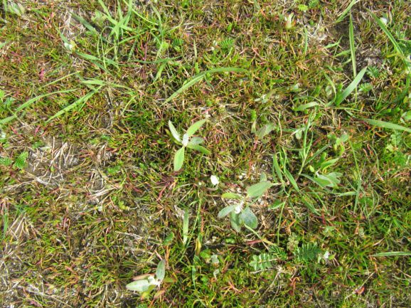
3.2.1 General description of areas surveyed
Map 2 shows the locations of all areas surveyed for saltmarsh habitats.
• Carrigtohill:
Most of the area mapped by the SMP at Carrigtohill (SMP site code SMP0060), adjacent to Fota Golf
Course, was revisited (Map 3), and the four assessment stops recorded for this survey were located
as close as possible to the original SMP stops. The area at Slatty Bridge to the east of the site,
originally included within the Carrigtohill site by the SMP, is described separately below.
A number of small areas of 1330 Atlantic salt meadows are present at this site, all of the Puccinellion-
type community. Most of these are CM1 Lower saltmarsh, but one larger area of CM2 Upper
saltmarsh is present in the east of the site. Some very small areas of the Annex I habitat 1310
Salicornia mud, mapped during the SMP, were also relocated, although the time of year was early for
Salicornia spp. and cover of the species was therefore low. Creeks and pans were present in some
BEC Consultants Ltd – June 2014 13PRJ95 – Assessment of the Conservation Status of the Great Island Channel SAC
areas. A small area of infilling was noted in one part of the site, but apart from this, recent human
interference with the structure of the saltmarsh was absent. A small embankment or accretion ridge,
apparently present for some time and now supporting upper saltmarsh species, was recorded in one
part of the site, but as saltmarsh vegetation is present on lower ground on either side of this ridge, it
does not appear to be having any deleterious effect on the saltmarsh habitats adjacent to it.
Woodland beside the saltmarsh is shading out some of the adjacent saltmarsh vegetation.
No change was noted between the Annex I saltmarsh habitats mapped in 2008 during the SMP and
those mapped during this survey.
The SMP describes this site in detail, and reference should be made to McCorry & Ryle (2009), SMP
site code SMP0060, for further information.
• Bawnard:
The entire area mapped by the SMP at Bawnard (SMP site code SMP0057) was revisited (Map 4),
and three of the four stops for this survey were relocated as close as possible to the original SMP
stops and reassessed. One of these three stops was found to be located in habitat that no longer
conformed to 1330 Atlantic salt meadows, so the stop was relocated to a position as close as possible
to the SMP stop location but within 1330 Atlantic salt meadows habitat. Part of this site (where two of
the stops were recorded) includes narrow strips of saltmarsh habitat being subjected to coastal
squeeze (in which saltmarsh is unable, in the event of rising sea levels, increases in tidal ranges or
increases in wind and wave energy, to retreat in a landward direction because of a physical barrier;
JNCC, 2004) by a seawall on one side, and to Spartina encroachment on the other side. There was
also evidence at this site of damage from the winter storms of 2013/14, with a large uprooted tree
noted at the eastern end of the site. It is thought that some areas of bare shingle may have been
newly exposed because of extreme wave action.
The SMP describes this site in detail, and reference should be made to McCorry & Ryle (2009), SMP
site code SMP0057, for further information.
• Lough Atalia:
O’Donoghue et al. (2009) identified 1330 Atlantic salt meadows adjacent to Lough Atalia lagoon. The
current survey agreed with their habitat assignment, two monitoring stops were recorded and the area
was mapped (Map 5). Both the Armerion- and Puccinellion-type communities were recorded in this
4
area, with discrete areas of Atriplex portulacoides, Armeria maritima and Juncus gerardii , as well as
transitions between the different types. The area appears to be undisturbed, apart from a small ditch
where Spartina is present but confined, and the saltmarsh is well developed. This saltmarsh
conforms to the lagoon type of saltmarsh, the occurrence of which is described by Curtis (2003) as
rare in Ireland.
• Harpers Island:
O’Donoghue (2008) noted the development of saltmarsh at Harpers Island (Map 6) due to a seawall
breach which was allowing sea water onto what had previously been improved agricultural grassland.
A lagoon has formed, and water now appears to be entering the lagoon from under the embankment
that surrounds the island. This area, 11 ha in size, is now grazed by a small number of horses (two at
the time of survey). Juncus gerardii grows by the lagoon edge, which is almost entirely mud and
green algae (Enteromorpha sp.). Salicornia sp. is present, emerging from the mud, with the remains
of last year’s Salicornia plants still in evidence and covering a large area. In a band adjacent to the
mud is a strip of CM1 Lower saltmarsh vegetation, with Glaux maritima, Carex otrubae, Potentilla
anserina and Elytrigia repens. This vegetation grades into GS1 Dry neutral grassland. However,
4
All English names of plants given in Appendix III
BEC Consultants Ltd – June 2014 14PRJ95 – Assessment of the Conservation Status of the Great Island Channel SAC zonation within the saltmarsh vegetation areas is minimal due to the overall flat nature of the site and the lack of water level fluctuation. To the southeast of the lagoon, the habitat is a combination of: GA1 Improved agricultural grassland with locally abundant Bellis perennis; CM2 Upper saltmarsh, characterised by Agrostis stolonifera, Rumex crispus, Potentilla anserina, Bolboschoenus maritimus and Carex otrubae; and pioneer CM1 Lower saltmarsh, characterised by large areas of bare mud being colonised by Salicornia sp., with Atriplex prostrata, Potentilla anserina, Juncus gerardii and Spergularia media also present in this habitat. Green algae are locally abundant. This area was deemed to be likely to conform to the Annex I habitat 1310 Salicornia mud, which is not a qualifying interest for the SAC and was therefore not assessed. This potentially represents (or will develop into) a lagoon saltmarsh. • Slatty Bridge: An area of 3 ha at Slatty Bridge was surveyed (Map 7) as it was identified and mapped by O’Donoghue et al. (2009) as 1330 Atlantic salt meadows with Agrostis stolonifera, Alopecurus geniculatus, Aster tripolium and Carex otrubae recorded as present. The SMP, however, identified this area as non-saltmarsh. On walking this polygon for the current survey, no saltmarsh species were in evidence, the only species in common with the O’Donoghue et al. (2009) survey being Agrostis stolonifera, with the entire area now referable to GA1 Improved agricultural grassland rather than CM2 Upper saltmarsh. On the basis that the SMP did not assign this area to Annex I habitat, this is not regarded as a loss of habitat since the SMP survey. • Belvelly: To the east of Belvelly Castle, large areas of Spartina swards are visible on the mudflats. O’Donoghue et al. (2009) mapped 1330 Atlantic salt meadows on the area fringing the Spartina swards to the south. The current survey agreed with this habitat assignment, two 1330 monitoring stops were recorded and the area mapped (Map 8). The main species present in this extensive area is Puccinellia maritima, with good cover also of species such as Triglochin maritimum, Plantago maritima and Glaux maritima. While Spartina is extensive adjacent to these areas, the presence of erosion cliffs between the 1330 Atlantic salt meadows and the Spartina swards prevents or impedes spread of the latter into the Annex I habitat. • Rossmore: Annex I saltmarsh was mapped by Atkins at Rossmore, and this area was visited to characterise the current status of this habitat. Pioneer 1330 Atlantic salt meadows habitat was surveyed and mapped (Map 9) adjacent to a lagoon, and one assessment stop was recorded. Cover of Salicornia sp. was high, particularly considering the early time of year for this species. Cover of green algae was also high. This area was deemed to be pioneer 1330 Atlantic salt meadows rather than 1310 Salicornia mud due to the presence of Puccinellia maritima, which is a characteristic species of 1330 Atlantic salt meadows but is not associated with 1310 Salicornia mud. As for Lough Atalia and Harpers Island, the saltmarsh at this area is of the lagoon type. • Midleton: A large area of potential 1330 Atlantic salt meadows habitat identified from a desktop study by the SMP was visited at Midleton. This area was mapped as CM2 Upper saltmarsh by O’Donoghue et al. (2009). However, the current survey found that this area conformed more to a grassland habitat, intermediate between GS2 Dry meadows and GS4 Wet grassland. Species recorded here include Elytrigia repens, Festuca rubra, Poa pratensis, Calystegia sepium, Filipendula ulmaria, Cardamine pratensis, Urtica dioica, Holcus lanatus, Galium aparine, Potentilla anserina, Epilobium hirsutum, Iris BEC Consultants Ltd – June 2014 15
PRJ95 – Assessment of the Conservation Status of the Great Island Channel SAC

pseudacorus, Oenanthe crocata and Solanum dulcamara.                             Small amounts of Schoenoplectus
tabernaemontani were also present.
A smaller area of habitat identified by O’Donoghue et al. (2009) as CM2 Upper saltmarsh, Annex I
habitat 1130 (sic), located approximately 200 m to the southeast of the area described above, was
also surveyed. This area was found to be CM2 Upper saltmarsh dominated by Elytrigia repens and
Agrostis stolonifera, and was therefore not deemed to conform to 1330 Atlantic salt meadows. Areas
fringing small brackish pools (too small to map) were found to contain a greater diversity of more
typical saltmarsh species such as Triglochin maritimum, Aster tripolium and Beta vulgaris ssp.
maritima, and similar habitat was seen on the small island directly to the west across the estuary
(Map 10), although this was not walked. While the surveyed area was flat with little or no zonation,
the island was slightly sloping, with some zonation of vegetation evident.

3.2.2     Area (Extent) assessment
Table 9 shows the extent of 1330 Atlantic salt meadows habitat mapped in the SAC by the SMP in
2008, and its current area mapped for this project. Results show a slight decrease in the extent of
this Annex I habitat between 2008 (McCorry & Ryle, 2009) and 2014. No change in extent could be
detected from aerial photographs or Bing Maps between 2000 and 2014 for areas of 1330 Atlantic salt
meadows habitat not mapped during the SMP. The main loss of habitat was noted at Bawnard,
where a combination of coastal squeeze and storm damage resulted in the loss of 0.02 ha of the
Annex I habitat.
When the 3.12 ha areas of additional 1330 Atlantic salt meadows habitat mapped by this survey
(including mosaics and the viewed area of probable 1330 at Midleton) are taken into account, this
represents a loss of 0.45% of the 4.48 ha of 1330 habitat mapped in the Great Island Channel SAC,
an annual loss of 0.07% over the six years from 2008 to 2014. Referring to Table 1 for area decline
percentage thresholds, this gives an assessment result of Unfavourable – Inadequate for the Area
(extent) criterion.

Table 9. Area (Extent) of 1330 Atlantic salt meadows recorded in Great Island Channel SAC in 2008 (SMP) and
                                               resurveyed in 2014.

               Site             Area in SAC in         Area in 2014 (ha)         Change in         % annual change
                                  2008 (ha)*                                     area (ha)          (over 6 years)

            Bawnard                   0.35                    0.33                  -0.02              0.95 (loss)

           Carrigtohill               1.03                    1.03                    0                     0

        Additional areas              3.12                    3.12                    0                     0

              Total                   4.50                    4.48                  -0.02              0.07 (loss)
* Note: some areas of 1330 surveyed by the SMP and resurveyed for this project were located outside the SAC but included in
the SMP area totals, so this figure differs from that presented in McCorry & Ryle (2009) for the extent of 1330 habitat at these
sites.

3.2.3     Structure and functions assessment
A total of 12 monitoring stops were recorded for the assessment of the 1330 Atlantic salt meadows
habitat recorded in the Great Island Channel SAC. This included the recording of full 2 m x 2 m
relevés, with percentage cover recorded for each species (see Appendix II). Assessment was made
on the basis of five main criteria, following the SMP methodology (McCorry & Ryle, 2009).
Physical structure: This relates to the condition of creeks and pans (if any), with particular reference to
human alteration of these physical saltmarsh features, the target being no further human alteration of
creek function, for example, by recent drainage (McCorry & Ryle, 2009). Creeks or pans were

BEC Consultants Ltd – June 2014                                                                                             16
PRJ95 – Assessment of the Conservation Status of the Great Island Channel SAC
present in the vicinity of 6 of the 12 stops assessed. There was no evidence of human alteration of
the physical structure of the 1330 Atlantic salt meadows habitat at any of the areas assessed in the
current survey.
Vegetation structure: There are three components to vegetation structure, namely zonation, plant
height and cover of bare ground.
• Zonation: McCorry & Ryle (2009) describe the main target of the zonation component as the
maintenance of a range of plant zonation typical of the site, taking account of site size, and noting
any evidence of coastal squeeze. Coastal squeeze was noted at two of the 12 stops, while
normal zonation was exhibited in the vicinity of the other ten stops.
• Plant height: The main target of the plant height component was to maintain site-specific
structural variation in the sward, McCorry & Ryle (2009) giving a reference guideline ratio of 25%
tall to 75% short vegetation throughout the whole saltmarsh for the SMP. While actual threshold
heights for tall and short were not supplied, it was assumed for this survey that low woody species
such as Limonium humile and Atriplex portulacoides would be of a height typical of the tall
vegetation referred to by McCorry & Ryle (2009), while the majority of the herbaceous vegetation,
comprising species such as Puccinellia maritima and Spergularia media, would have heights
typical of the short vegetation. Uniform plant height was recorded at 25% of the stops, with a
further 25% of stops having a high proportion (>75%) of tall vegetation. One stop (8%) had equal
amounts (50:50 ratio) of tall and short vegetation. The remaining 42% of stops had a relatively
low proportion (25-33%) of tall vegetation, in line with the guideline ratio. McCorry & Ryle (2009)
assessed this criterion over the habitat as a whole rather than at individual stops. On this basis,
there was sufficient height variation throughout the different areas surveyed to pass this criterion.
• Cover of bare ground: Cover of bare ground was assessed at 10 of the 12 stops, stops with more
than 5% bare ground in low to upper salt marsh failing the criterion. The two stops that were not
assessed were in pioneer saltmarsh, so this criterion is not deemed to apply to them.
Vegetation composition: Two criteria are assessed under this heading: typical species and negative
indicator species.
• Typical species: This relates to the presence of a threshold number and cover of typical
species, with the typical species varying depending on the habitat zone in which the stop was
recorded. However, the criteria cited in the SMP report were set at the beginning of the SMP
project, and McCorry & Ryle (2009) noted the difficulty of setting typical targets for each
Annex I habitat due to the dependence of species diversity on zonation, and a degree of
expert judgement was used during the SMP for the assessment of this criterion (McCorry,
pers. comm.). Following consultation with McCorry, species composition of stops was
compared with that of SMP stops, where applicable; all were broadly in line with those
recorded in 2008 except one stop (stop 7), which had suffered a decline in species diversity
and cover and an increase in dominance by one species since 2008. For the five stops
recorded de novo, expert judgement was exercised with relation to the nature of the species
present, and all were found to have a typical assemblage of species present. Thus one stop
was judged to have failed this criterion.
• Negative indicator species: Only one stop failed this criterion, Spartina appearing to be in the
process of expanding in the vicinity of one stop in Bawnard since the SMP stop was recorded
in 2008.
Other negative indicators: Other indicators of negative effects on the habitat were assessed, including
reclamation, drainage, pollution, vehicle tracks, poaching and overuse. Two stops failed on this
criterion, one through pollution/litter and overuse (presence of trampling), the other through pollution
alone.
BEC Consultants Ltd – June 2014 17You can also read