Application of Residential Parking Standards in the London Borough of Barnet - Phase 4 - June 2021
←
→
Page content transcription
If your browser does not render page correctly, please read the page content below
Application of Residential
Parking Standards in the
London Borough of Barnet
– Phase 4

June 2021

 We care about place
Project No: CS/101426 Doc Ref: CS/101426 Rev: P04

Client: Re
Issue Date: June 2021

Application of Residential Parking Standards in the
London Borough of Barnet – Phase 4
Technical Note

 Name Signature Date

 Author Steph Malson 17/06/2021

 Checker Martin Dolan 17/06/2021

 Approver Dave James 17/06/2021

 Issue Record

 Rev Date Description/Comments Author/Prepared by: Approved for Issue by:

 P01 30/04/21 Draft S. Malson D. James

 P02 11/05/21 Final S. Malson D. James

 P03 17/05/21 Minor amendments S. Malson D. James

 P04 17/06/21 Minor amendments S. Malson D. James

 “The report shall be for the private and confidential use of the clients for whom the report is undertaken and should not be reproduced
 in whole or in part or relied upon by third parties for any use whatsoever without the express written authority of the Consultant”

 We care about place
This report has been prepared by Capita Property and Infrastructure Limited (Capita) in favour of RE/London
Borough of Barnet (“the Client”) and is for the sole use and benefit of the Client in accordance with the agreement
between the Client and Capita dated 18/01/2018 under which Capita’s services were performed. Capita accepts
no liability to any other party in respect of the contents of this report. This report is confidential and may not be
disclosed by the Client or relied on by any other party without the express prior written consent of Capita.

Whilst care has been taken in the construction of this report, the conclusions and recommendations which it
contains are based upon information provided by third parties (“Third Party Information”). Capita has for the
purposes of this report relied upon and assumed that the Third Party Information is accurate and complete and
has not independently verified such information for the purposes of this report. Capita makes no representation,
warranty or undertaking (express or implied) in the context of the Third Party Information and no responsibility is
taken or accepted by Capita for the adequacy, completeness or accuracy of the report in the context of the Third
Party Information on which it is based.

Capita understands and acknowledges the Authority’s legal obligations and responsibilities under the Freedom of
Information Act 2000 (the “Act”) and fully appreciates that the Authority may be required under the terms of the
Act to disclose any information which it holds. Capita maintains that the report contains commercially sensitive
information that could be prejudicial to the commercial interests of the parties. On this basis Capita believes
that the report should attract exemption from disclosure, at least in the first instance, under Sections 41 and/
or 43 of the Act. Capita accepts that the damage which it would suffer in the event of disclosure of certain of the
confidential information would, to some extent, reduce with the passage of time and therefore proposes that any
disclosure (pursuant to the Act) of the confidential information contained in the report should be restricted until
after the expiry of 24 months from the date of the report.

 We care about place
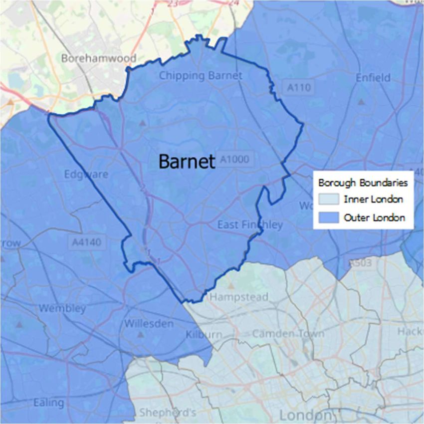
APPLICATION OF RESIDENTIAL PARKING STANDARDS IN THE LONDON BOROUGH OF BARNET

 PHASE 4 TECHNICAL NOTE

This technical note builds on the evidence-based suggestions on how the current maximum standards
should be interpreted and applied as set out in the February 2019 report ‘Application of Residential
Parking Standards in the London Borough of Barnet’ (Figure 1). It provides a recommended
methodology for calculating the radial (towards London) and orbital (around London) gain of public
transport provision to reinforce the Council’s ability to set parking standards according to local
circumstances.

This technical note concludes Phase 4 of the review of the application of residential parking standards
in the London Borough of Barnet (LBB).

Phase 1 (October 2017) recommended defining residential parking standards by both PTAL and
property size, based on evidence from the census data;

Phase 2 (January 2018 then issued as combined report with Phase 1 February 2018) investigated and
tested the impact of using orbital PTAL ; and

Phase 3 (December 2018 then issued as combined report with Phases 1 & 2 February 2019) proposed
revised residential parking standards based on PTAL, property size but with relaxations applied where
orbital connections were poor within a relatively high PTAL area.

 Figure 1 Location Plan

 © OpenStreetMap

In the new London Plan (March 2021), the Mayor has set maximum residential parking standards for
the boroughs of outer London which are based on both Public Transport Accessibility Levels (PTAL), a
measure of connectivity by public transport (i.e. how close a place is to public transport and how
frequent services are in the area), and the number of beds per dwelling (Table 1).
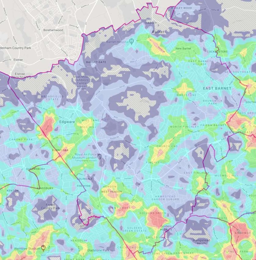
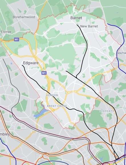
Table 1 New London Plan (March 2021) Maximum Residential Parking Standards extract
 Location Number of beds Maximum parking provision*
 All areas of PTAL 5 – 6 All Car free~
 Outer London Opportunity Areas All Up to 0.5 spaces per dwelling
 Outer London PTAL 4 1–2 Up to 0.5 – 0.75 spaces per dwelling#
 Outer London PTAL 4 3+ Up to 0.5 – 0.75 spaces per dwelling#
 Outer London PTAL 2 – 3 1–2 Up to 0.75 spaces per dwelling
 Outer London PTAL 2 – 3 3+ Up to 1 space per dwelling
 Outer London 0 – 1 1–2 Up to 1.5 spaces per dwelling
 Outer London 0 – 1 3+ Up to 1.5 spaces per dwelling^
 * Where Development Plans specify lower local maximum standards for general or operational parking, these should be followed
 ~ With the exception of disabled persons parking, see Part G Policy T6 .1 Residential parking
 # When considering development proposals that are higher density or in more accessible locations, the lower standard shown here
 should be applied as a maximum
 ^ Boroughs should consider standards that allow for higher levels of provision where there is clear evidence that this would support
 additional family housing

The current residential parking standards within the borough are set out in Barnet’s Local Plan
Development Management Policies (September 2012), where Policy DM17: Travel impact and parking
standards states that, ‘the council will expect development to provide parking in accordance with the
London Plan standards, except in the case of residential development, where the maximum standards
will be:

 i. 2 to 1.5 spaces per unit for detached and semi-detached houses and flats (4 or more
 bedrooms);
 ii. 1.5 to 1 spaces per unit for terraced houses and flats (2 to 3 bedrooms); and
 iii. 1 to less than 1 space per unit for development consisting mainly of flats (1 bedroom).’

These maximum standards are broadly comparable to the March 2021 London Plan for developments
that fall within PTAL 0-1 locations but are significantly in excess for sites where the PTAL is 2 or above.
Paragraph 18.8.2 of Barnet’s Local Plan notes the need to consider sensitivity to local circumstances
and identifies the level of public transport accessibility and on-street parking controls as key factors in
assessing the flexibility to be applied to parking standards.

Figure 2 illustrates that large areas of the borough have poor levels of accessibility with a PTAL of 2 or
less and Figure 3 demonstrates that areas of high PTAL’s follow the line of the London Underground
Northern line, both arms of which pass through Euston Station before moving on to destinations south
of the River Thames.

 Figure 2 PTAL’s in Barnet Figure 3 Underground routes in Barnet

 © Google Maps LUL Northern Line © Google Maps
In addition, the Midland Main Line from Sheffield to London St Pancras and the Great Northern line,
which terminates at Moorgate Underground Station, also pass through the borough. Both these
national rail lines have a north-west to south-east alignment where they pass through Barnet
improving the radial (towards London) accessibility with minimal impact to the orbital (around
London) provision.

Data from the 2011 census revealed that average car ownership per dwelling in Barnet (see Table 2)
was below the current maximum standards allowed in DM17 for all property sizes. In 2011 the car
ownership in smaller households, with a maximum of two bedrooms, were shown to be less than 55%
of the standards permitted for new residential developments. The average number of vehicles per 2-
bedroom households varies between wards from 0.62 to 0.96, with an average of 0.81. The highest
vehicle ownership levels are in Mill Hill, Totteridge, High Barnet & Hale.

 Table 2 Average vehicles/household
 Bedrooms/ Vehicles/Dwelling
 Dwelling Barnet DM17 Policy 2011 Census
 1 0 to 1 0.53
 2 0 to 1.5 0.81
 3 0 to 1.5 1.14
 4 0 to 2 1.53
 5+ 0 to 2 1.76

During the 10-year period between census data collections the number of households with no vehicles
registered increased by 15.1%, which is more than double the percentage increase in the total number
of households. These figures demonstrate that there is an increasing number of households that do
not own a vehicle.

Following analysis of this dataset, along with a review of both the dwelling size and PTAL’s for
residential developments completed between 2015 and 2017, the recommendations of the February
2019 report were for Barnet to define parking standards in two dwelling size categories (1/2-bed units
and 3+ units) with a decreasing allowance for developments with greater PTAL’s (see Table 3).
Furthermore, the report recommended that consideration be given to relaxing standards where there
is a less favourable orbital provision of public transport.

 Table 3 Maximum Residential Parking Standards - Draft London Plan 2017 & Proposed LBB 2019
 PTAL Draft London Plan 2017 Proposed LBB (February 2019)
 Outer London 1/2 bed units 3+ bed units
 0 1.5* 1.25 1.5
 1 1.5* 1.25 1.5
 2 0.75 1 1.25
 3 0.75 0.75 1
 4 0.5 - 0.75 0.5~ 0.75~
 5 Car Free Car Free - 0.5^
 6 Car Free Car Free
 * Where small units (generally studios and one-bedroom flats) make up a proportion of a development, parking provision
 should reflect the resultant reduction in demand so that provision across the site is less than 1.5 spaces per unit.
 ~ Where orbital PTAL is calculated to be less than or equal to 3, development should include close to the maximum
 parking provision allowable
 ^Where CPZ's are in place and orbital PTAL is calculated to be greater than or equal to 4, development should be car free.

In a review of Barnet’s Draft Local Plan in January 2020, the Transport for London (TfL) expressed
concerns, which were endorsed by the Greater London Authority (GLA) Built Environment Director

with delegated authority from the Mayor of London, over the approach at PTAL 5 stating that a
‘provision as high as 0.5 spaces per dwelling represents a level that is significantly higher than the
Intend-to-Publish London Plan and something we would object to in principle.’

TfL commented that ‘just 4 per cent of Barnet residents’ bus trips are to central London, while 90 per
cent stay in outer London, demonstrating that buses are predominantly used for more local trips,
regardless of the direction of travel’. However, they were particularly concerned that the use of orbital
PTAL was ‘not a robust, objective measure’ and requested that all reference to orbital PTAL is removed
and replaced by a reference to the travel time mapping (TIM) functionality of Web-based Connectivity
Assessment Toolkit (WebCAT).

The TfL ‘Assessing transport connectivity in London’ report explains that PTAL is a measure of the
density of the public transport network and does not consider ‘the destinations you can travel to from
each location’ and recommends that professional judgement be applied ‘when analysing PTAL outputs
and to interpret any result in the relevant context’. The TIM functionality of WebCAT allows the user
to create maps showing ‘how long it takes to travel between one selected place and all other places.’

TIM provides an important strategic visual representation of both existing and potential connectivity
of sites, as well as the difference between them. However, it does not enable the user to determine
a quantifiable value that can be used by the Council to specify parking requirements. In comparison,
the PTAL functionality of WebCAT offers an unambiguous, structured approach to calculating a value
that can be used by both the Council and developers.

In addition, TfL requested that the proposed standards align with the Intend-to-Publish London Plan
London for ‘Metropolitan and Major town centres to be car-free, and for development in outer London
Opportunity Areas to have no more than 0.5 spaces per dwelling on average (apart from where more
restrictive standards apply)’.

There are two defined Opportunity Areas (OA) in Barnet designated in the Mayors London Plan. A
third OA has been designated, in New Southgate, but does not yet have a geographic boundary.

Table 4 shows how the new London Plan (March 2021), which defines residential parking standards
using both PTAL and two dwelling size categories (1/2-bed units and 3+ units), compares with the
maximum standards that were proposed for Barnet in 2019.

 Table 4 Residential Parking Standards - London Plan (March 2021) & Proposed LBB (February 2019)
 London Plan Proposed LBB Parking Standards
 (March 2021) (February 2019)
 Maximum parking provision Maximum parking provision
 1/2 bed units 3+ bed units 1/2 bed units 3+ bed units
 0 1.5 1.5 1.25 1.5
 1 1.5 1.5 1.25 1.5
 2 0.75 1 1 1.25
 3 0.75 1 0.75 1
 4 0.5-0.75 0.5-0.75 0.5~ 0.75~
 5 Car Free Car Free Car Free-0.5^ Car Free-0.5^
 6 Car Free Car Free Car Free Car Free
 ~ Where orbital PTAL is calculated to be less than or equal to 3, development should include close to the maximum
 parking provision allowable
 ^Where CPZ's are in place and orbital PTAL is calculated to be greater than or equal to 4, development should be car free.

 Lower than new London Plan Exceeds new London Plan
Recommendations With the introduction of the two dwelling size categories in the new London Plan the Council’s previous proposals are now broadly aligned with these maximum standards. The Council therefore now recommends that the maximum parking standards for Barnet are based on the following: PTAL 0-1 The new London Plan 2021 maximum parking standards for Outer London for locations with a PTAL of less than or equal to 1 is up to 1.5 space per unit for all unit sizes. Table 2 shows that the average number of vehicles for 4-bedroom properties in 2011 was recorded as 1.53 per unit, this is only slightly higher than the new London Plan allowance of 1.5 per unit, irrespective of its size, for PTAL 0-1 sites. We recommend that a LBB maximum standard of 1.25 space per unit for 1/2-bedroom properties is adequate for locations with a PTAL of less than or equal to 1, with an increase to 1.5 spaces per unit for properties with three or more bedrooms. PTAL 2 & 3 For locations with a PTAL of 2 or 3 the new London Plan 2021 allows up to 0.75 spaces per unit for 1/2-bedroom properties and up to 1 space per unit for 3+ bedroom properties. A high proportion of LBB is located within a PTAL 2 area (Figure 2) but a review of the 2011 census data in Barnet shows that the average number of vehicles per 2-bedroom households varies between wards from 0.62 to 0.96, with a borough average of 0.81 vehicles per unit. In 2011, the borough average for households with 3 or more bedrooms was 1.35 vehicles, with the average for all households being 1.065 vehicles, per unit. Whilst the public transport accessibility in these areas is poor the allocation of a single parking space for 75% of the smaller, and all larger households enables the majority of residents to have shared access to a vehicle within the household and will encourage car-sharing behaviour. We recommend the new London Plan allowances for locations with a PTAL of 2 or 3 is adopted by the LBB. PTAL 4 For locations with a PTAL of 4, the new London Plan 2021 maximum parking standards for Outer London is up 0.5-0.75 spaces per unit for all unit sizes. The higher end of this range is only 0.06 less than the average 2011 vehicle ownership for 2-bedroom properties. Phase 2 of this project highlighted that an area with a good PTAL does not necessarily provide adequate orbital public transport links. This potentially limits access to employment and leisure opportunities across the borough. We recommend the new London Plan allowances for locations with a PTAL of 4 is adopted by the LBB including the table note that where development proposals have a higher density or are in more accessible locations, the lower standard should be applied as a maximum. PTAL 5 The new London Plan 2021 deems that locations with a PTAL of 5 should be car-free. It is worth noting that less than 2% of the London Borough of Barnet sits within a PTAL 5 location. Where Controlled Parking Zones (CPZs) are in place and orbital PTAL is calculated to be more than or equal to 4, we recommend the new London Plan is adopted by the LBB and developments should be car-free. However, where these criteria are not met the parking standards should be increased to 0.5 spaces per unit for car club schemes where suitable, to encourage movement around the borough,
with developer contributions towards enhancing bus services to improve the orbital accessibility of the local area and extending Controlled Parking Zones. PTAL 6 The new London Plan deems that locations with a PTAL of 6 should be car-free. It is reasonable to assume that developments within these areas will attract residents because of their public transport accessibility. We recommend the new London Plan Car-Free policy for locations with a PTAL of 6 is adopted by the LBB. A summary of the proposed maximum parking standards for the London Borough of Barnet are shown in Table 5 below. The standards mirror the new London Plan closely with lower standards for 1/2- bedroom units in low PTAL areas and relaxations to the proposed LBB standards, with developer contributions towards improving orbital bus services and CPZ’s required, where properties are developed in areas of PTAL 5 but with poor orbital public transport accessibility. Where overall PTAL is 5, yet orbital PTAL is 4 or below, a relaxation to allow minimal parking for car club schemes only would be considered, along with a developer contribution made towards improving the orbital range of bus service provision and Controlled Parking Zones (CPZ’s). Table 5 Residential Parking Standards for London Borough of Barnet (April 2021) Proposed LBB Parking Standards (April 2021) Maximum parking provision* 1/2 bed units 3+ bed units 0 1.25 1.5^ 1 1.25 1.5^ 2 0.75 1 3 0.75 1 4 0.5-0.75# 0.5-0.75# 5 Car Free~! Car Free~! 6 Car Free~ Car Free~ * Metropolitan and Major Town Centres to be Car Free~; and Up to 0.5 spaces per dwelling be allowed for developments within Opportunity Areas. ~ With the exception of disabled persons parking, see Part G Policy T6 .1 Residential parking. ! Where the orbital PTAL is 4 or less minimal parking for car club schemes to be considered. # When considering development proposals that are higher density or in more accessible locations, the lower standard shown here should be applied as a maximum. ^ Boroughs should consider standards that allow for higher levels of provision where there is clear evidence that this would support additional family housing. To enable orbital PTAL to be determined easily the Council recommends that a customer facing web- based calculation tool be devised. Used in conjunction with TfL’s WebCAT, this would hold the co- ordinates of the start and end points of all bus services in Barnet, enabling the user to select the bus services and input the AI scores identified WebCAT, to calculate the orbital PTAL for a desired development location.
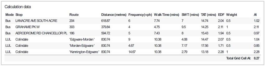
Calculating Orbital PTAL
Improving the orbital connectivity of bus services within Barnet is vital if suitable alternatives to the
car are to be effective. However, the Council acknowledges TfL’s concerns and recognises that to
enable orbital PTAL to be used effectively a robust methodology is required so that the calculations
are not open to inconsistencies and challenge.

The recommended process, set out in Appendix A, uses the PTAL calculation report available from
WebCAT and applies transparent calculations to measure the relative radial (towards London) and
orbital (around London) gain of each bus service. Appendix B includes a worked example of the
calculations for Aerodrome Way in Colindale.

As both London Underground Northern lines pass through Euston Station before heading south of the
River Thames, this has been chosen as the radial centre of London (OSGB 529520 182749) for Barnet.
Furthermore, as the underground and national rail lines contribute minimal orbital gain and pass
through, or close, to Euston (within 1km), the radial centre point, they are considered as being fully
radial.

Each development site of interest can be located using an address, co-ordinates or by clicking the
cursor on the desired location of the map in the WebCAT planning tool. Selecting of the Access level
tab generates a PTAL report which includes calculation data that determines the Access Index1 (AI)
used to determine the associated PTAL. Figure 4 shows the calculation data for Aerodrome Way in
Colindale that is obtained using this process.

 Figure 4 WebCAT PTAL calculation data for Aerodrome Way, Colindale

WebCAT provides PTAL’s based on the frequency of services during the morning (08:15 – 09:15)
weekday peak. They are calculated by summing AI the bus services within 640m and rail/underground
services within 960m. The AI is based on the walking distance, at a speed of 4.8kmph) to the public
transport service, combined with the associated frequency and wait times.

If the service provided an even split between both radial and orbital directions, then the Access Index
range could be considered as half the value for either orbital or radial PTAL’s. Table 6 shows the
existing relationship between the Access Index range and the PTAL value and the proposed
relationship for a single direction, thereby giving the defined Access Index range for segregated radial
or orbital journeys.

1
 Access Index (AI) This index is one of the stages in calculating PTAL values. An Access Index value is
calculated for each transport service that the PTAL value is composed of (combining walk time and service wait
time). The total Access Index for all services is used to derive the PTAL.
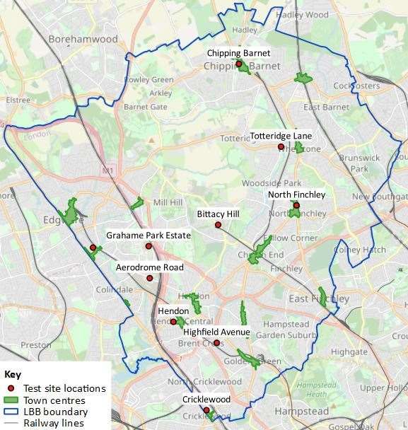
Table 6 PTAL- Access Index relationship Segregated Access Index Range PTAL Access Index Range 0 0 (worst) 0 0.01 – 2.50 1a 0.01 – 1.25 2.51 – 5.0 1b 1.26 – 2.5 5.01 – 10.0 2 2.51 – 5.0 10.01 – 15.0 3 5.01 – 7.5 15.01 – 20.0 4 7.51 – 10.0 20.01 – 25.0 5 10.01 – 12.5 25.01 – 40.0 6a 12.51 – 20.0 40.01+ 6b (best) 20.01+ Ten site locations, shown in Figure 5, were chosen to test out the impact of using a radial-orbital split methodology to ascertain the relative PTAL’s. The five sites used in February 2019 report, plus an additional five town centre locations: Highfield Avenue, Brent Cross; Grahame Park Estate, Colindale; Totteridge Lane, Totteridge; Aerodrome Way, Colindale; Bittacy Hill, Mill Hill; Burnt Oak Town Centre; Chipping Barnet Town Centre; Cricklewood Town Centre; North Finchley Town Centre; and Hendon Central Town Centre. Figure 5 Radial-Orbital split test site locations © OpenStreetMap
Table 7 gives the results of the analysis using the recommended Radial-Orbital PTAL split
methodology.

 Table 7 – Test sites results for Radial-Orbital PTAL split
 Access Radial Radial Orbital Orbital
 Index (AI) PTAL AI PTAL AI PTAL
 Highfield Avenue, Brent Cross 20.89 5 15.25 6a 5.64 3
 Grahame Park Estate, Colindale 2.14 1a 0.75 1a 1.39 1b
 Totteridge Lane, Totteridge 10.83 3 7.54 4 3.29 2
 Aerodrome Way, Colindale 8.27 2 5.60 3 2.67 2
 Bittacy Hill, Mill Hill 9.99 2 6.91 3 3.08 2
 Burnt Oak Town Centre 20.86 5 14.23 6a 6.63 3
 Chipping Barnet Town Centre 20.16 5 10.21 5 9.95 4
 Cricklewood Town Centre 24.75 5 10.04 5 14.71 6a
 North Finchley Town Centre 13.79 3 7.25 3 6.54 3
 Hendon Central Town Centre 23.12 5 17.49 6a 5.63 3

The results show that of the five locations where the PTAL is 5, so would require car free residential
developments, 60% have a higher radial PTAL but an orbital PTAL of 3. The condition of the residential
parking standards would enable the Council to grant a relaxation in these locations to allow minimal
parking spaces for car club schemes where suitable, whilst seeking contributions from the developer
to improve the orbital provision of public transport and CPZ’s.
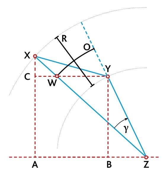
Appendix A Calculation of Radial-Orbital PTAL split using triangulation

To calculate the relative radial-orbital PTAL split, the OSGB co-ordinates of the start and end of each
bus service listed in the WebCAT PTAL calculation report are required. The start and end locations are
located using the TfL Bus Route finder2 tool, then the Easting and Northing co-ordinates can be
obtained using the UK Grid Reference Finder3 and applying the triangulation method described below.

 The radial gain (R) for each bus route listed in the TfL WebCAT planning tool PTAL report
 is calculated using the Pythagoras Theorem. The OSGB (Ordnance Survey Great Britain)
 co-ordinates of the start (X) the end (Y) of the bus route are compared against those of
 Euston Station (Z) to determine the length of line XZ and YZ. The shorter of these is then
 subtracted from the larger to give a value for R.

 Length XZ = ( ) + ( )²

 Length YZ = ( ) + ( )²

 Radial distance, R = Length XZ – Length YZ

 The Pythagoras Theorem is again used to
 calculate the distance (XY) between the start
 and end points of the route and the cosine
 rule is applied to calculate gamma (γ).

 Length XY = ( ) + ( )²

 ( )²+ (YZ)² - (XY)²
 = cos
 2( )( )

 The orbital gain (O) for each bus route is determined by multiplying the distance from
 Euston Station (Z) to the mid-point of the radial distance (R), length WZ by gamma (γ) in
 radians.

 Orbital distance, O =(WZ)γ (where γ is in radians)

 The Access Index is then split by the ratio of the radial and orbital distances to obtain the
 radial and orbital Access Indices.

2
 https://tfl.gov.uk/modes/buses/
3
 https://gridreferencefinder.com/
Appendix B Worked example of calculating Orbital PTAL for Aerodrome Road, Colindale

 AZ² or BZ² AX² or BY² XZ or YZ R (XZ-YZ)
Aerodrome Road, Colindale To Euston
Bus Route AI Location Easting Northing E-W dist. ² (m) N-S dist. ² (m) CF dist. (m) Radial dist (m)
 Edgware Bus Station 519538 191886 99640324 83484769 13532
 204 1.02 772
 Sudbury Town Station 516939 184881 158281561 4545424 12760
 Edgware Bus Station 519538 191886 99640324 83484769 13532
 303 2.11 1481
 Kingsbury Circle 519098 188801 108618084 36626704 12052
 Brent Cross Shopping Centre 523219 187804 39702601 25553025 8078
 186 0.97 5802
 Northwick Park Hospital 516487 187523 169859089 22791076 13880
 LUL 1.04 Edgware-Morden
 LUL 0.85 Morden-Edgware
 LUL 2.28 Kennington-Edgware

 8.27

 CY² CX² XY O Orbital Radial
 Start to End
 E-W dist. ² N-S dist. ² CF dist. Circumference Orbital dist.
 Bus Route AI (m) (m) (m) Gamma (m) (m) Orbital AI Radial AI

 204 1.02 6754801 49070025 7472 33 82601 7538 0.93 0.09

 303 2.11 193600 9517225 3116 12 80375 2752 1.37 0.74

 186 0.97 45319824 78961 6738 19 68983 3568 0.37 0.60

 LUL 1.04 1.04
 LUL 0.85 0.85
 LUL 2.28 2.28

 8.27 2.67 5.60
We care about place www.re-ltd.co.uk

 Re (Regional Enterprise) Ltd
2 Floor Building 4, North London Business Park, Oakleigh Road South, London N11 1NP
 nd
You can also read