Application of low-power wide-area network GPS to koala monitoring
←
→
Page content transcription
If your browser does not render page correctly, please read the page content below
CSIRO PUBLISHING
Australian Mammalogy                                                                                              Research Note
https://doi.org/10.1071/AM21001

      Application of low-power wide-area network GPS
      to koala monitoring

      Allie Richardson A, Sean FitzGibbon A, Benjamin Barth A, Amber Gillett A and
      William Ellis A,B
      A
          School of Agriculture and Food Science, The University of Queensland, Brisbane, Qld 4067, Australia.
      B
          Corresponding author. Email: w.ellis@uq.edu.au

      Abstract. We evaluated long range antennae and associated solar-powered global positioning system (GPS) ear tags
      designed for use with domestic cattle, as a novel system for monitoring ranging behaviour of the koala (Phascolarctos
      cinereus). The mean location error of our GPS tags was 33.9 m (s.e. ¼ 0.46). The tags were relatively light (30 g), reported
      eight locations per day when attached to koala radio-collars and had an operating life that exceeded our study period
      (8 months). Deployed as a stand-alone, solar powered, remote system, this technology can provide a viable option for
      wildlife tracking projects.

      Keywords: fix success, location data, LoRaWAN, movement patterns, solar-power, spatial ecology.

      Received 11 January 2021, accepted 3 July 2021, published online 27 July 2021

Introduction                                                            addition, we monitored the koala population that utilises the
Global positioning system (GPS) technology is widely used to            Belmont Hills Reserve (–27.5096148, 153.1202268), a dedicated
acquire location data for spatial analysis in wildlife research         green space in the Brisbane suburb of Carindale in southeast
(Tomkiewicz et al. 2010). Hand-held GPS units have been                 Queensland.
replaced by small tags carried by the subject species, reducing
observer-created artefacts that can affect behavioural studies          Data collection
and resulting in location data collected at predefined intervals,       The low-power wide-area network (LPWAN) system we used is
providing more locations than traditional VHF methods (Bandeira         accessed by the company ‘Moovement’TM (https://moovement.
de Melo et al. 2007; Read et al. 2007; Mandel et al. 2008; Frair        com.au). It relies on low power, LoRa wireless transmission over
et al. 2010).                                                           large distances (5–40 km, depending on topography) (Mekki
    We have previously used purpose-built store-on-board wild-          et al. 2018). The tags are small (30 g, 45  55  10 mm, Fig. 1a)
life tracking collars (Ellis et al. 2011; Robbins et al. 2019a,         solar-powered polycarbonate-enclosed cattle ear tags, which
2019b) and repurposed commercial GPS tags to attach to VHF              communicate with LoRa gateways. Each gateway consists of an
tracking collars (Ellis et al. 2016) to conduct such studies on         antenna attached to a standard wireless router, containing a cel-
koalas. Here we investigated the use of a low-power long-range          lular sim card which communicates with the network server,
(LoRa) system, to collect and transmit location data from koalas,       delivering the data through a user portal (Amazon Quicksight)
in urban and rural settings. Our aim was to test the functionality of   and mobile phone application (‘Moovement BV’). Prior to this
this technology to collect spatial data for koalas. If the extended     study, the ability of the LoRa system to provide biologically
battery life and low weight of the GPS tags, paired with the            useful data had not been reported, although the system is being
standalone field base stations that complete the systems, proved        trialled on American bison (Bison bison) (American Prairie
suitable for wildlife research, high quality data at relatively low     Reserve, pers. comm. 2020).
cost could be within reach of many research teams.                          To evaluate GPS accuracy, we deployed two stationary tags
                                                                        at each study site; one in an exposed location, and one placed
Materials and methods
                                                                        beneath the canopy to imitate conditions experienced by koalas.
Study sites                                                             These tags were programmed to collect one fix every hour,
In 2013 we established and began monitoring a translocated              continuously.
population of koalas at ‘Tandora’ (–25.4540548, 152.8037708),               Additional GPS tags, also programmed to transmit a location
a privately owned cattle station located 20 km northeast of             once every hour, were attached to the collars of nine radio-
Maryborough, Queensland, from where koalas were extirpated              tracked koalas between April 2020 and December 2020; four at
over 100 years ago (Miller 2018; FitzGibbon et al. 2020). In            Tandora and five at Belmont Hills. The tags were attached with

Journal compilation  CSIRO 2021 Open Access CC BY-NC-ND                                                 www.publish.csiro.au/journals/am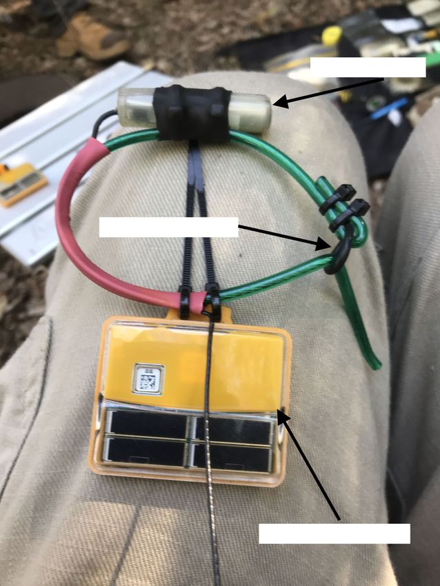
B Australian Mammalogy A. Richardson et al.
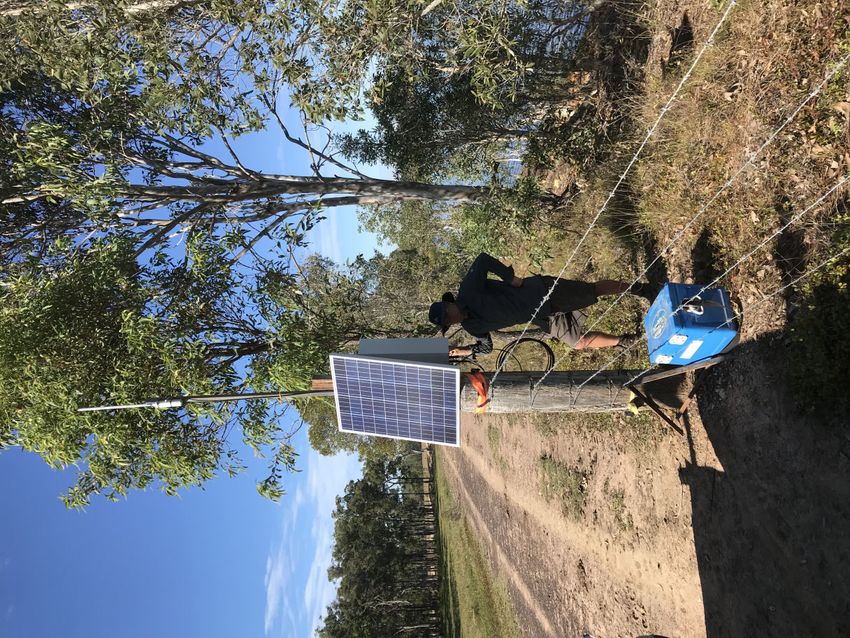
(a ) (b )
VHF Transmitter
Degradable O-Ring
Moovement GPS Unit
Fig. 1. (a) Koala collar in construction, with vhf and MoovementTM tag attached. Rubber o-ring used as flexible and degradable weak link. Lead weight
not attached to VHF. (b) Autonomous, solar-powered gateway established at Tandora to monitor collared koalas during 2020. Photographs by W. Ellis.
cable ties to a polycore filament collar which simultaneously We then plotted the reported fix accuracy values for each fix
carried a VHF transmitter (Advanced Telemetry Systems, of the stationary tags against their corresponding calculated
model A2650, 25 g) and lead weight (acting as a counterbalance error, to visualise the relationship between these measures and to
25 g) which dorsally aligned the GPS tag on the koala (Fig. 1a). detect threshold fix accuracy values suitable for koala range and
Collars had a built-in rubber o-ring designed to stretch and movement analysis. Fix success rate was calculated from the
degrade over time (Ellis et al. 2015), to release in the event of ratio of attempted and successful fixes for each tag, as a measure
collar failure or collar becoming ‘snagged’ or even in the event of likely output (both for stationary and on-animal tags). To
of unsuccessful recapture. assess the cost-effectiveness of the LoRa system, cost per fix
At Tandora, we established an autonomous, solar-powered was calculated from equipment costs and total number of
LoRa antenna (Fig. 1b); at Belmont, a local resident provided received fixes for both stationary tags and deployed koala tags,
access to mains (240V DC) power enabling the establishment of to complement the study of Matthews et al. (2013).
a mains-powered system. In addition, we powered a LoRa
antenna from a second battery system in our research vehicle, Ethical statement
providing a mobile data collection platform for use at either site.
Study methods were approved by the University of Queensland
Office of Research Ethics (SAFS/528/18) and conducted under
Data analysis
Scientific Purposes Permit WISP16162915.
We have previously calculated the average location error for
Sirtrack GPS tags (Ellis et al. 2011, 2016) and for repurposed
commercial GPS tags (iGotU; Ellis et al. 2015) and undertook a Results
similar analysis here. For each stationary tag, the reported fix All four stationary GPS tags transmitted location data for the
quality (fix accuracy value, in metres) of each location was entire data collection period between April and November 2020,
assessed for actual distance from the known location of the tag, receiving 9527 of a possible 20 712 (46%) location reports (one
to calculate true location accuracy. Distances were calculated as tag was re-deployed for use with a koala collar in September).
the geodesic distance (the shortest path between two points on Fix success rate of the individual tags ranged from 14 to 60%,
the earth at sea level) between the reported fix and true location, with an average of 10.8 fixes per tag, per day and an average
using the haversine formula. error across all stationary tags of 33.9 m (s.e. ¼ 0.46). There wasGPS monitoring of koalas Australian Mammalogy C
Hence, we recommend to only use locations with fix accuracy
values within the daily average movement distance of the subject
40 y = 0.73(x ) + 5.7, R 2 = 0.926
species. For animals moving smaller distances, for which loca-
Actual distance error (m)
tion fix inaccuracy would be greater than actual movement, the
technology may be unsuitable.
30 Removing all reported locations for which reported fix
accuracy is greater than a value of 50 m maintains 70% of the
original fixes and is likely to retain more than one fix per day (our
20 mean fix rate was approximately 9 per koala, per day) resulting in
increased average fix accuracy. Across the deployed tags (on
koalas), 15–18% of fixes (or approximately one per day) reported
10 accuracy better than 30 m. Careful data filtering could therefore
result in few, high quality fixes per day (per koala), allowing
detailed range analysis comparable to VHF and some other GPS
10 20 30 40 50
tracking data to be undertaken. Hence complete, longer-term
Reported fix accuracy range analysis, investigating resource selection, patterns of
movement and even tree selection similar to previous studies in
Fig. 2. Calculated fix accuracy (y axis) and reported location error (x axis)
Queensland, (Davies et al. 2013) and New South Wales
for stationary tags deployed at Tandora and Belmont Hills, Queensland.
Only data for reported accuracy below 50 m are included.
(Crowther et al. 2014) should be possible using this technology.
Fix success rate varied between koala deployments, which is
consistent with other reports for GPS deployments (Frair et al.
2010); in our study, the overall average fix success rate was
a positive linear relationship between fix accuracy value and negatively impacted by a single koala with a fix success rate of
calculated location error for stationary tags at fix accuracy 3%, due to the collar rotating so that the GPS sky view was
values of 50 or less (Fig. 2, R2 ¼ 0.926), indicating that reported obscured. Our overall fix success rate was just under half of all
fix accuracy values in this range closely approximated actual fix acquisition attempts (46% stationary, 17–50% deployed); repro-
error. Average error for locations with a fix accuracy value less graming tags to collect more locations during periods of animal
than 50 m was 19.3 m (s.e. ¼ 1.34). activity, and less during the daytime (when koalas are invariably
All tags deployed on koalas supplied location data, however under canopy and relatively sedentary), could result in a more
two tags supplied fewer than (on average) one fix per day, two useful data set to understand koala activity.
koalas were only monitored for part of the study (added after the Setting aside data for koalas that left the study site or for
study began and hence not included in analyses) and one koala which tag failure could be attributed to ‘operator error’ (failure
moved out of range of the gateway during the study. The average to properly attach and counterbalance the tag), approximately
daily fix rate of the remaining five tags was 8.6 fixes per day, ten fixes per day, of which almost 70% will be more accurate
with a range of less than 1 to more than 13 fixes per day. The than 50 m, can be expected using the Moovement system with
mean reported fix accuracy of all deployed tags was 46.8 m koalas. Many studies of spatial dynamics of koalas have relied
(s.e. ¼ 0.47; corresponding to 39.9 m, Fig. 2). All data are on a single daily location (Ellis et al. 1990; Lassau et al. 2008;
available in ZoaTrack (Dwyer et al. 2015). Ellis et al. 2009; de Oliveira et al. 2014; Goldingay and Dobner
The total cost of equipment for the two LoRa systems 2014; Matthews et al. 2016; Barth et al. 2020) and the LoRa
including the fixed costs of standalone gateways, data portal system we trialled can produce data of similar quality and
access and tags (30) was AU$11 709. From 10 958 successful quantity. The current tags are light and small and were easily
fixes across four stationary tags and seven koalas between April modified for attachment to koala collars. They could similarly
and September, the mean calculated cost per fix (excluding be used to monitor other species of sufficient body size (e.g.
labour) was AU$0.93. The cost per tag is very low (AU$60 per possums, macropods). At present, the system does not incorpo-
tag) so cost per fix should be lower for longer (or larger) projects. rate features such as accelerometry to detect illness or death, as
Deployed tags have continued to report locations for more than can be done with the Lx system (Robbins et al. 2019b). Fossorial
12 months and their operating life expectancy is unknown. and strictly nocturnal species may be less suitable for this
system, given the reliance of the tags on solar recharging, but
Discussion the portable multi-platform interface and simple setup of this
The aim of this study was to assess the potential of LoRa systems system are key advantages over current alternatives.
to inexpensively deliver high quality data to wildlife research-
ers. For Queensland koalas, a medium sized (4–10 kg adult) Conflict of interest
species that spends most of its life in trees, this system can
deliver reliable, near real time indications of location for long The authors declare no conflicts of interest.
term (.12 months) studies.
Overall average location error of the tags (33.9 m) fell within the Declaration of funding
reported average daily movement distance of the koala in central This project was supported by San Diego Zoo Wildlife Alliance,
Queensland (53.6–63.3 m; Ellis et al. 2009) and slightly above that Brisbane City Council, The Everhard Foundation and The Koala
reported in southeast Queensland (22.4 m; Barth et al. 2020). Ecology Group.D Australian Mammalogy A. Richardson et al.
Acknowledgements populations in suitable, unoccupied landscapes within the species’ range
We thank Lindsay Titmarsh for supporting koala research at Tandora, (CSAR17013). Queensland Government.
Wayne Jenkins for technical advice and construction work and Nancy Frair, J. L., Fieberg, J., Hebblewhite, M., Cagnacci, F., DeCesare, N. J., and
Cramond for allowing us to erect our equipment on her property at Belmont. Pedrotti, L. (2010). Resolving issues of imprecise and habitat-based
locations in ecological analyses using GPS telemetry data. Philosophical
Transactions: Biological Sciences B 365, 2187–2200. doi:10.1098/
References
RSTB.2010.0084
Bandeira de Melo, L. F., Lima Sabato, M. A., Vaz Magni, E. M., Young, R. J., Goldingay, R. L., and Dobner, B. (2014). Home range areas of koalas in an
and Coelho, C. M. (2007). Secret lives of maned wolves (Chrysocyon urban area of north-east New South Wales. Australian Mammalogy
brachyurus Illiger 1815): as revealed by GPS tracking collars. Journal of 36(1), 74–80. doi:10.1071/AM12049
Zoology 271, 27–36. doi:10.1111/J.1469-7998.2006.00176.X Lassau, S. A., Ryan, B., Close, R., Moon, C., Geraghty, P., Coyle, A., and
Barth, B., FitzGibbon, S., Gillett, A., Wilson, R., Moffitt, B., Pye, G., Adam, Pile, J. (2008). Home ranges and mortality of a roadside Koala Phasco-
D., Preece, H., and Ellis, W. (2020). Scattered paddock trees and road- larctos cinereus population at Bonville, New South Wales. In ‘Too close
side vegetation can provide important habitat for koalas (Phascolarctos for comfort: Contentious issues in human-wildlife encounters.’ (Eds
cinereus) in an agricultural landscape. Australian Journal of Mammal- D. Lunney, A. Munn, W. Meikle) pp. 127–136. (Royal Zoological
ogy 42(2), 194–203. doi:10.1071/AM18031 Society of New South Wales). doi:10.7882/FS.2008.018
Crowther, M. S., Lunney, D., Lemon, J., Stalenberg, E., Wheeler, R., Mandel, J. T., Bildstein, K. L., Bohrer, G., and Winkler, D. W. (2008).
Madani, G., Ross, K. A., and Ellis, M. (2014). Climate-mediated habitat Movement ecology of migration in turkey vultures. Proceedings of the
selection in an arboreal folivore. Ecography 37(4), 336–343. National Academy of Sciences 105, 19102–19107. doi:10.1073/PNAS.
doi:10.1111/J.1600-0587.2013.00413.X 0801789105
Davies, N., Gramotnev, G., Seabrook, L., Bradley, A., Baxter, G., Rhodes, J., Matthews, A., Ruykys, L., Ellis, B., FitzGibbon, S., Lunney, D., Crowther,
Lunney, D., and McAlpine, C. (2013). Movement patterns of an arboreal M., Glen, A., Purcell, B., Moseby, K., Stott, J., Fletcher, D., Wimpenny,
marsupial at the edge of its range: a case study of the koala. Movement C., Allen, B., Van Bommel, L., Roberts, M., Davies, N., Green, K.,
Ecology 1(1), 8. doi:10.1186/2051-3933-1-8 Newsome, T., Ballard, G., Flemming, P., Dickman, C., Eberhart, A.,
de Oliveira, S. M., Murray, P. J., de Villiers, D. L., and Baxter, G. S. (2014). Troy, S., McMahon, C., and Wiggins, N. (2013). The success of GPS
Ecology and movement of urban koalas adjacent to linear infrastructure collar deployments on mammals in Australia. Australian Mammalogy
in coastal south-east Queensland. Australian Mammalogy 36(1), 45–54. 35(1), 65–83. doi:10.1071/AM12021
doi:10.1071/AM12046 Matthews, A., Lunney, D., Gresser, S., and Maitz, W. (2016). Movement
Dwyer, R. G., Brooking, C., Brimblecomb, W., Campbell, H. A., Hunter, J., patterns of koalas in remnant forest after fire. Australian Mammalogy
Watts, M. E., and Franklin, C. E. (2015). An open Web-based system for 38(1), 91–104. doi:10.1071/AM14010
the analysis and sharing of animal tracking data. Animal Biotelemetry 3. Mekki, K., Bajic, E., Chaxel, F., and Meyer, F. (2018). A comparative study
doi:10.1186/S40317-014-0021-8 of LPWAN technologies for large-scale IoT deployment. ICT Express 5,
Ellis, W. A. H., White, N. A., Kunst, N. D., and Carrick, F. N. (1990). 1–7. doi:10.1016/J.ICTE.2017.12.005
Response of koalas (Phascolarctos cinereus) to re-introduction to the Miller, L. (2018). Determining site carrying capacity of reintroduced koalas
wild after rehabilitation. Australian Wildlife Research 17(4), 421–426. (Phascolarctos cinereus) in a rural landscape. The University of Queens-
doi:10.1071/WR9900421 land, Brisbane.
Ellis, W., Melzer, A., and Bercovitch, F. B. (2009). Spatiotemporal dynam- Read, M. A., Grigg, G. C., Irwin, S. R., Shanahan, D., and Franklin, C. E.
ics of habitat use by koalas: the checkerboard model. Behavioral Ecology (2007). Satellite tracking reveals long distance coastal travel and homing
and Sociobiology 63(8), 1181–1188. doi:10.1007/S00265-009-0761-2 by translocated estuarine crocodiles, Crocodylus prosus. PLoS ONE
Ellis, W., Bercovitch, F., FitzGibbon, S., Roe, P., Wimmer, J., Melzer, A., 2(9), e949. doi:10.1371/JOURNAL.PONE.0000949
and Wilson, R. (2011). Koala bellows and their association with the Robbins, A., Hanger, J., Jelocnik, M., Quigley, B. L., and Timms, P. (2019a).
spatial dynamics of free-ranging koalas. Behavioral Ecology 22(2), 372– Longitudinal study of wild koalas (Phascolarctos cinereus) reveals
377. doi:10.1093/BEHECO/ARQ216 chlamydial disease progression in two thirds of infected animals.
Ellis, W., FitzGibbon, S., Pye, G., Whipple, B., Barth, B., Johnston, S., Scientific Reports 9, 13194. doi:10.1038/S41598-019-49382-9
Seddon, J., Melzer, A., Higgins, D., and Bercovitch, F. (2015). The Role Robbins, A., Loader, J., de Villiers, D., Beyer, H. L., and Hanger, J. (2019b).
of Bioacoustic Signals in Koala Sexual Selection: Insights from Seasonal Predation by carpet pythons (Morelia spilota) is an important cause of
Patterns of Associations Revealed with GPS-Proximity Units. PLoS mortality in a free-living koala (Phascolarctos cinereus) population in
ONE 10(7), e0130657. doi:10.1371/JOURNAL.PONE.0130657 South East Queensland. Australian Veterinary Journal 97(9), 351–356.
Ellis, W., FitzGibbon, S., Barth, B., Niehaus, A., David, G., Taylor, B. D., doi:10.1111/AVJ.12840
Matsushige, H., Melzer, A., Bercovitch, F., Carrick, F., Jones, D., Dexter, Tomkiewicz, S. M., Fuller, M. R., Kie, J. G., and Bates, K. K. (2010). Global
C., Gillett, A. K., Prevadec, M., Lunney, D., and Wilson, R. (2016). positioning system and associated technologies in animal behaviour and
Daylight saving time can decrease the frequency of wildlife–vehicle ecological research. Philosophical Transactions: Biological Sciences
collisions. Biology Letters 12, 20160632. doi:10.1098/RSBL.2016.0632 365, 2163–2176. doi:10.1098/RSTB.2010.0090
FitzGibbon, S., Gillett, A., Barth, B., Hulse, L., and Ellis, W. (2020). A new
approach to conserving Queensland’s koalas: re-establishing koala
www.publish.csiro.au/journals/amYou can also read