AN APPROACH TO CHARACTERISE AGRICULTURAL LIVELIHOODS AND LIVELIHOOD ZONES USING NATIONAL CENSUS DATA IN TIMOR-LESTE
←
→
Page content transcription
If your browser does not render page correctly, please read the page content below
Expl Agric. (2018), volume 54 (6), pp. 857–873         C Cambridge University Press 2017. This is an Open Access article,
                 distributed under the terms of the Creative Commons Attribution licence (http://creativecommons.org/licenses/by/4.0/),
                 which permits unrestricted re-use, distribution, and reproduction in any medium, provided the original work is properly cited.
                 doi:10.1017/S0014479717000436

                        A N A P P ROAC H TO C H A R AC T E R I S E AG R I C U LT U R A L
                          LIVELIHOODS AND LIVELIHOOD ZONES USING
                             NAT I O NA L C E N S U S DATA I N T I M O R - L E S T E

                                    By ROBERT L. WILLIAMS†‡§††, SAMUEL BACON†‡,
                                    ADALFREDO FERREIRA†‡ and WILLIAM ERSKINE§¶
                     †Seeds of Life Timor-Leste, Dili, PO Box 221, Timor-Leste, ‡Ministry of Agriculture and
                    Fisheries (MAF), Comoro, Dili, Timor-Leste, §Centre for Plant Genetics and Breeding (PGB),
                      UWA School of Agriculture and Environment, University of Western Australia, 35 Stirling
                    Highway, Crawley, WA 6009, Australia and ¶Institute of Agriculture, University of Western
                                   Australia, 35 Stirling Highway, Crawley, WA 6009, Australia

                                        (Accepted 24 July 2017; First published online 9 October 2017)

                                                                          SUMMARY
                        This research aimed to develop a typology of agriculture in Timor-Leste using national census data at
                        the village level. Although Timor-Leste is a relatively small nation, its varied topography contains a rich
                        diversity in agricultural livelihoods, from coffee covered mountains, to dryland-swidden agriculture. Each
                        of the livelihoods are very complex, with a single household often managing more than 10 crop and 4–
                        5 animal species in very small holdings. Using census data from each village only, statistical clustering
                        analysis was used to group villages with similar levels of participation in crop and livestock production.
                        The clustered village groups were then mapped, and it was seen that villages in each cluster, occupied
                        particular locations. Using expert knowledge about the locations of each cluster, livelihood zones based on
                        a small number of rules were defined to mimic the output of the clustering. Seven livelihood zones were
                        identified from mapping the livelihood systems. These included three zones with irrigation (rice-based),
                        two highland zones (coffee-based) and two lowland zones based on rain-fed agriculture. Government and
                        development agencies have endorsed the typology of livelihood zones, which is now in use for planning
                        and decision-making. The technique of using national census data to define agricultural zones through
                        statistical clustering can be replicated wherever there is reliable village-level census data.

                                                                     I N T RO D U C T I O N

                 Agriculture is important in Timor-Leste’s economy and culture. More than 70% of
                 the population lives in rural areas, with 63% active in cropping and more than 86%
                 involved in raising animals (MOF, 2011). The country is very mountainous, with
                 four peaks above 2200 m within an area approximately 240 km long by 60 km wide
                 (Supplementary Figure S1). The wide topographic diversity of Timor-Leste supports
                 a wide range of crops despite its small area.
                    Elevation and north/south aspect are the main drivers of variation for annual
                 rainfall totals across the country (Figure S2). The lowest rainfall areas lie along the
                 north coast (< 1000 mm) and the highest rainfall areas are associated with high

                 ††Corresponding author: Email: rob.williams@seedsoflifetimor.org

Downloaded from https://www.cambridge.org/core. IP address: 46.4.80.155, on 26 Jan 2022 at 11:12:23, subject to the Cambridge Core terms of use, available at
https://www.cambridge.org/core/terms. https://doi.org/10.1017/S0014479717000436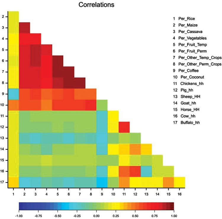
858                                        RO B E RT L . W I L L I A M S       et al.

                   elevations. The north coast has a single short wet season, whereas the south coast
                   has a bimodal wet season. The bimodal season not only reduces the length of the dry
                   season, but also contributes to an increased total annual rainfall.
                      Efficient resource allocation for agriculture development is hindered by the
                   highly variable landscape, and diverse farming systems, even in small areas. Rural
                   development programs are often allocated to work in a single one out of the country’s
                   12 rural districts. Faced with major diversity of agricultural livelihoods within any
                   one district, progress is often hampered by spreading meagre resources across a large
                   range of activities. All but one district include some flat coastal areas, and cooler
                   mountainous regions with highly diverse systems of agriculture. An approach that
                   could group villages into particular agricultural zones – based on their agricultural
                   systems – would allow more targeted rural development nationally. Currently, the
                   country has no method for defining the locations and types of agricultural zones
                   nationally. Efficient rural development requires a simple method to define the location
                   and description of livelihood zones across the country. Such a method needs to
                   be easy to apply but to be consistent with the quantitative data available for each
                   village.
                      In a first attempt at describe the climate zones of Timor-Leste, ARPAPET devised
                   a system that splits the country into six agro-ecological zones based on elevation and
                   north/south aspect (ARPAPET, 1996). There are three zones in the north facing side
                   of the island, and three on the south facing side. The coastal zone extends from sea
                   level to 100 m elevation, the next zone is from 100 to 500 m elevation, and above
                   500 m is the third zone. More recently Molyneux et al. (2012) added a seventh
                   (temperate) zone for areas above 2000 m in elevation, where temperate crops such
                   as wheat, barley, plums and peaches are grown.
                      The ARPAET classification was based only on elevation and aspect, and was
                   unable to include aspects of the farming system, and the types of crops grown
                   and animals raised. As such the zoning was unable to direct or guide development
                   activities based on similar agricultural activities. For example, the presence/absence
                   of an irrigation system and local preference for particular animals were not reflected
                   in the ARPAPET zones.
                      The Ministry of Agriculture and Fisheries (MAF) and development community
                   were looking for a way to zone the rural areas of Timor–Leste based on the farming
                   systems. Such zoning would need to rely on extensive knowledge from a group of
                   experts concerning the whole country, or some national level data available for all 442
                   villages in Timor-Leste. Expert knowledge based on every village was not considered
                   feasible, so zoning had to rely on quantitative-national data sets.
                      Kostrowicki (1977) presented a summary of the theoretical basis of agricultural
                   typologies and the distinction of typology and regionalisation. A regionalisation is
                   based on the location of the agricultural activity, and is static by nature, whereas the
                   typology is responding to the type of agriculture conducted and is dynamic over time.
                   The current system in Timor-Leste, of seven agro-ecological zones, is a static regional
                   system. A typology is a dynamic system that is based not on differences between
                   locations, but the similarities of the types of activities between locations.

Downloaded from https://www.cambridge.org/core. IP address: 46.4.80.155, on 26 Jan 2022 at 11:12:23, subject to the Cambridge Core terms of use, available at
https://www.cambridge.org/core/terms. https://doi.org/10.1017/S0014479717000436
A typology of Timorese agriculture 859
Typology development requires a number of steps. The first two steps are
intertwined and are (1) the selection of the variables to be utilised and (2) the
methods by which the similarities are measured. Kostrowicki (1977) did not make
firm recommendations on the variables to be included or the way that similarity
is measured, but left those choices to researchers involved. Once the typology is
established, the third and final step is to delimit agricultural zones by generalisations
of the more complex typology pattern to a simpler regional picture, based on the
dominance or co-dominance of individual types over a given region.
Timor-Leste has not completed an agriculture census since the restoration of
independence (2002) but has completed many other national level surveys. These
include the income and expenditure household survey, demographic household and
Nutrition survey (DHS, 2009/2010). Unfortunately, all of these surveys are quite small
and only sample a small percent of the population, which does not include all villages.
For example, the most recent latest DHS survey sampled less than a quarter of the
442 villages.
By contrast, the national census (2005 and 2010) covered every single household
in the country (MOF, 2011). The most recent census asked each household about
the range of agricultural activity the household was involved in. Each household was
asked whether they grew any of 10 crops or crop types, and how many of each seven
animals they had in the household at the time of survey.
There are many different variables and methods to type variables together to group
farming systems into different types. Some typologies use only the dominant crop to
delineate homogeneous systems (Kelley et al., 1997) even though Kostrowicki et al.
(1977) recommended a wide range of variables.
Given the demand for clear agricultural zones, and the availability of census data
at the village level, the research question is: Can a descriptive and relatively simple
map of agricultural zones be produced from village census data using Timor-Leste as
the example.
This research paper follows on the theoretical basis of typology development with
the aim of developing a useful typology of Timorese agriculture for agricultural
planning using national census data. The paper first summarises the agriculture
information from the national census of 2010, and then based on a hierarchical
clustering technique, groups villages that have similar agriculture systems. Based on
the output of the statistical clustering the types of agriculture system were defined,
and then a set of simple rules were developed to present a typology of agriculture
in Timor-Leste. The resulting typology was then tested with practitioners and
professionals in the field.
METHODS
Census data and cluster analysis
This study used agricultural variables from national census data to develop
a typology for agricultural livelihoods in Timor-Leste. A population census was
conducted throughout Timor-Leste in 2010. The reference date for the village
Downloaded from https://www.cambridge.org/core. IP address: 46.4.80.155, on 26 Jan 2022 at 11:12:23, subject to the Cambridge Core terms of use, available at
https://www.cambridge.org/core/terms. https://doi.org/10.1017/S0014479717000436860 RO B E RT L . W I L L I A M S et al.
census was midnight 11/12 July 2010 (MOF, 2014). Enumerators asked questions
and recorded responses of each household in Timor-Leste from 12–25 July. The
questionnaire consisted of 6 parts (and 82 questions), and was developed in a
participatory approach with many branches of government and civil society. Under
Section 5, named ‘housing and household amenities’ section, households were asked
which crops they grew (if any) and the number of each type of animal(s) held by the
household.
There were 10 options for crops grown in the census. These were five individual
species (rice, maize, cassava, coffee and coconut) and five crop groups (vegetables,
temporary fruit, permanent fruit, other temporary crops and other permanent crops).
Temporary fruits include pineapples, passionfruit and papaya. Permanent fruits
include fruit trees such as mangoes, jack fruit and citrus and other permanent
crops such as cloves, cinnamon and candle nut. Households reported if they grew
each crop/crop type or not. There was no minimum threshold area or amount of
production for each crop. In addition to the number of crops grown, each household
gave information on the numbers of seven species of animals, namely chicken, pig,
sheep, goat, horse, cow and buffalo. All the above data are reported at the village level.
In addition, the number of farming households are reported, but only at a higher level
than the village (sub-district).
Only rural villages were considered in this typology. Of a total of 442 villages, 28
were defined as urban and excluded from the analysis. The excluded urban areas are
located in the national capital (Dili), as well as the capital cities of the rural districts and
sub-districts. The criterion to be a rural village was to have a population density below
500 people km−2 . The average population density of rural villages was 90 people m−2 .
National level data were summarised using two methods: The first method included
all households in rural areas. The second method only included households involved
in farming.
Village level data for the 414 rural villages were compiled into an Excel
spreadsheet. All data were analysed at the village level. The data included the number
of households that grow a range of 10 crops (and crop types), percentage of households
with each of the seven species of animals, and the average number of each animal per
household. In total this gave a matrix of 414 villages, each defined by 24 variables.
Cluster analysis was used to group similar villages based on the 24 agricultural
variables as in Joffre and Bosma (2009). The analysis combines villages with similar
levels of the 24 variables into groups of villages. The variation between the groups
is compared to the original variation between the 414 villages. As the number of
groups reduces from 414, the percent variation retained in the resulting groups also
reduces. At any step in the process, the analysis can be stopped and queried for
the number of groups, members of each group and the percent variation retained
between those groups. Choosing the end point of the clustering procedure was based
on the ‘elbow test’ (Thorndike, 1953) that balances percent of the variation retained
with a manageable and meaningful number of groups (Mooi and Sarstedt, 2011).
The hierarchical cluster analysis routine of GenStat 16 (VSN International, UK)
was used to complete the analysis. Group means were used to cluster similar groups
Downloaded from https://www.cambridge.org/core. IP address: 46.4.80.155, on 26 Jan 2022 at 11:12:23, subject to the Cambridge Core terms of use, available at
https://www.cambridge.org/core/terms. https://doi.org/10.1017/S0014479717000436A typology of Timorese agriculture 861
together as in Madry et al. (2013). Velicer and Jackson (1990) suggest that although
there are many different options in cluster analysis, in practice there is little difference
in the output.
Average characteristics of each of the livelihood groups (11) were computed and
mapped. Although no geographical data were used in the clustering analysis, villages
belonging to each livelihood group were generally located next to or near each other.
Based on a range of features of each livelihood, a set of rules was developed to mimic
the cluster analysis output as close as possible. Once the rules were formulated, they
were applied to each village, and each village was defined as one of the rule-based
livelihood zones, and finally maps of each of the zones were produced.
Geographic and social characteristics by group
This report also used a wide range of physical and social descriptors of each village.
Characteristics used in this analysis include elevation (m above sea level, asl), annual
rainfall total (mm), population density, adult literacy rate (%), percent births delivered
by trained assistant, access to electricity (%), percent of female headed households,
improved water supply (%), net school enrolment rate (%), sex ratio, distance (km) by
road to the district capital, distance (km) by road to national capital, Dili and a village
asset index. Village level data of these parameters were sourced from the ADB report,
least developed villages (ADB, 2013).
A one-way analysis of variance (ANOVA) by group was performed to determine if
the zones differed from each other for these indicators.
R E S U LT S
Each farming household in Timor-Leste grows a wide range of crops. More than two-
thirds of the cropping households grow maize, cassava, vegetables, fruit and other
non-specific temporary and permanent crops. Thus, amongst all rural households,
more than half grow maize, cassava, vegetables, fruit and other crops. Animal
production in households is similarly very common, with more than two-thirds of
rural households raising chickens and pigs. Larger animals are less common, with
only 12% of households raising buffalo. Among the seven animals recorded, sheep
are the least common – reported in only 4% of households nation-wide. As a result
of the high frequency of a wide range of cropping and animal raising activities, many
households have a diverse mix of many enterprises.
The spatial distribution of most cropping activities is not random across the
country. Maize and cassava are widely distributed across the country (Figures S3
and S4), whereas coffee and rice are localised in elevated areas and irrigated areas,
respectively (Figures S5 and S6). Sheep production is restricted to the northern and
drier coastal regions (Figure S7), while goats are mostly raised in the northern half
of the county in the central and western parts (Figure S8). Cattle are concentrated in
west and southern part of the nation (Figure S9), and buffalo are more clustered in
the southern and eastern parts (Figure S10).
Downloaded from https://www.cambridge.org/core. IP address: 46.4.80.155, on 26 Jan 2022 at 11:12:23, subject to the Cambridge Core terms of use, available at
https://www.cambridge.org/core/terms. https://doi.org/10.1017/S0014479717000436862 RO B E RT L . W I L L I A M S et al.
Figure 1. Correlation coefficient (r) matrix between 17 agricultural descriptors in 414 villages in Timor-Leste.
The correlation matrix (Figure 1) shows which activities are often associated with
each other. There are generally high positive correlations between the levels of
cropping of non-rice crops. For example, the level of maize grown in a village
is correlated to the level of cassava, fruit, vegetables and other crop production.
Rice production is not correlated with the production of other annual crops, but
is positively correlated with coconuts and negatively with coffee production. Coffee
planting is generally negatively correlated with animal production, especially buffalo.
Amongst the level of animal ownership, the levels of cow, pig and chicken
ownership are generally positively correlated with one another.
Clustering on cropping and animal ownership characteristics
The 11 groups formed as a result of cluster analysis, retained 83% of the variation
between the original 414 villages, and these generally correlate with the geography
Downloaded from https://www.cambridge.org/core. IP address: 46.4.80.155, on 26 Jan 2022 at 11:12:23, subject to the Cambridge Core terms of use, available at
https://www.cambridge.org/core/terms. https://doi.org/10.1017/S0014479717000436A typology of Timorese agriculture 863
and climate of Timor. Any further increase in the percent variation retained (and
number of groups) led to a large number of smaller splinter groups. Such smaller
splinter groups were not recognisable as coherent entities. For example, with an end-
point of 86% variation, the extra four groups had an average of five villages per group.
As a result the 83% variation threshold was selected.
Table 1 defines important characteristics of each of the 11 groups. Each group
is defined as a livelihood system. The number of villages in a livelihood system
ranged from 3 to 84, with nine of the 11 systems having 24 or more villages. Each
of the systems was characterised by which activities that were most different from
average.
Coffee growing households dominate four of the 11 systems identified in the cluster
analysis, and comprise 31% of the population. In these areas, more than 57% of
households grow coffee, which is above the national value of 44% of households
growing coffee (Table 1). The largest of the four coffee systems (78 villages) has
significant levels of coconut and vegetable production, and a high level of chicken
ownership. The next largest system (32 villages) has a very low level of animal owner-
ship; while a third system (24 villages) has a low level of cropping and animal
ownership. The fourth coffee system is small consisting of only three villages and
is distinguished in having high levels of chicken, pigs and coconut ownership in the
village.
Rice cropping dominates another set of three systems covering 96 villages overall
containing 240 000 households representing 30% of the population. Rice production
is spread throughout the country in pockets – from the western border with West
Timor, Oecussi, the Maliana plain, irrigation areas on the south coast, the Baucau–
Viqueque districts and elevated areas in the district of Los Palos (Figures S6 and
S11). The largest rice system (52 villages with 86 000 people) has a high level of
planting other crops and average animal diversity. The second rice system (24 villages,
24 000 people) has a much lower level of crop diversification. The third rice system
(20 villages, 20 000 people) has significant numbers of sheep and buffalo but an even
lower level of non-rice cropping. All the 14 villages with high sheep ownership are
on the North coast in Manatuto and Baucau in the driest part of the country, where
sheep production is suited.
The remaining four systems have a relatively low percent of households involved in
cropping. The largest of these four systems (84 villages, 185 000 people) have above
average numbers of large animals. Animal ownership is an important feature of two
of these remaining systems, and the last system has below average-level of cropping
and animal ownership.
Each of the 11 livelihood systems are associated with particular geographical areas
rather than randomly distributed across Timor-Leste (Figure 2). The first four systems
(based on coffee growing) are centred in the elevated cool inland regions of the island,
generally these areas are above the contour of 700 m above sea level with more than
2 000 mm of annual rainfall.
The rice-based livelihoods are in areas where there is irrigated land. As seen in
Figure S11, these villages are spread from the North coast, South coast and also some
Downloaded from https://www.cambridge.org/core. IP address: 46.4.80.155, on 26 Jan 2022 at 11:12:23, subject to the Cambridge Core terms of use, available at
https://www.cambridge.org/core/terms. https://doi.org/10.1017/S0014479717000436https://www.cambridge.org/core/terms. https://doi.org/10.1017/S0014479717000436
Downloaded from https://www.cambridge.org/core. IP address: 46.4.80.155, on 26 Jan 2022 at 11:12:23, subject to the Cambridge Core terms of use, available at
864
Table 1. Characteristics of the 11 distinct livelihood systems defined by cluster analysis, based on cropping and animal raising data from the national census. Crop data are
percentages of households in a village growing each crop/crop type (no minimum area), and data for animals are the numbers raised per household for each of seven animal
species averaged over the village.
# of villages
Fruit Temp.
Fruit Perm.
Temporary
Permanent
Population
Chicken #
Vegetables
Buffalo #
Coconut
Sheep #
Horse #
Cassava
Goat #
Cow #
Coffee
Maize
Crops
Crops
Pig #
Rice
Group Descriptor
Coffee and non-rice 78 117 772 15 86 87 75 83 83 69 64 80 81 4.2 2.0 0.1 0.8 0.4 0.9 0.4
RO B E RT L . W I L L I A M S
crops: Low animal
diversity
Coffee and non-rice 32 79 161 4 83 73 67 68 72 80 20 69 71 2.7 1.3 0.1 0.5 0.5 0.4 0.2
crops: v. low animals
Coffee: Low diversity 24 55 499 7 62 56 42 37 36 57 16 34 32 2.6 1.2 0.1 0.4 0.4 0.3 0.2
Coffee and coconuts: 3 1483 30 96 99 78 97 94 72 92 97 98 6.8 5.3 0.7 2.8 1.8 2.6 1.5
High diversity
Rice and upland 52 85 946 76 86 82 75 81 80 35 80 81 80 4.5 2.0 0.4 1.1 0.6 1.0 0.8
cropping: High
diversity
et al.
Rice, sheep and buffalo: 20 42 317 41 44 34 31 36 33 8 42 37 38 4.2 2.1 2.2 1.8 0.3 0.3 1.3
Low diversity
Rice: Low diversity 24 46 128 54 78 70 58 63 62 16 68 62 64 5.7 3.3 0.1 1.1 0.5 2.7 0.8
Buffalo and cows: Low 84 185 222 33 63 61 46 54 53 30 52 51 53 4.7 2.2 0.1 1.0 0.5 1.4 1.2
diversity
Cow: Low diversity 47 126 327 21 45 40 32 35 34 11 37 31 33 4.7 2.4 0.2 1.0 0.3 1.5 0.8
Goats, coconut, non-rice 10 16 720 1 78 77 28 71 73 33 69 64 65 4.4 2.1 0.1 2.3 0.1 0.2 0.1
crop: Low diversity
Non- specialised: Low 40 52 649 13 27 22 15 14 15 9 17 12 15 3.6 1.9 0.3 0.7 0.3 1.0 0.7
diversity
Mean 27 68 64 50 58 58 38 51 55 56 4.4 2.3 0.4 1.2 0.5 1.1 0.7A typology of Timorese agriculture 865
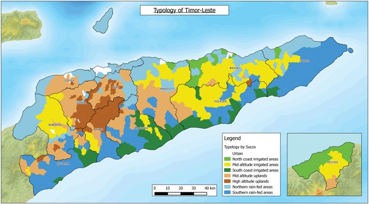
Figure 2. Map of livelihood zones of Timor-Leste with village boundaries.
mid-altitude areas. Rice cultivation in the dryer north coast is associated with sheep
and goat production; elsewhere rice-based villages raise other animals.
Livelihood systems based on large animals (buffalos and cows) lie mostly in the
southern half and eastern end of the country. There are also pockets of cattle
production on the central north coast and north-east end of the island.
Defining livelihood zones from livelihood systems information
The livelihood systems information was then used to define livelihood zones. As
a result of the geographic localisation of most of the livelihood systems, a proposal
of livelihood zones was established. Livelihood zones are areas where villages have
similar agriculture production and potential.
Based on the lessons learned from the cluster analysis, a set of rules was developed
to mimic of the outputs of the cluster analysis. These rules were then applied to each
village, and each village was allocated to one of the zones, based on simplified rules.
The matrix of the number of villages in each of the 11 groups based on cluster analysis
and the seven typology zones is given in Supplementary Table S1.
The cluster analysis showed that most of the differences between villages are based
on the level of rice and coffee production. Rice production regions are dependent by
irrigation availability and coffee production is limited by altitude/temperature and
rainfall. This contrasts to the situation of other crops such as maize and cassava
which have a wider adaptation and distribution across the country. As a result, the
definition of zones is primarily based on the intensity of rice and coffee production
among households in a village.
The first rule was therefore to separate rice growing villages from non-rice growing
villages. Rice zones are defined as having more than 35% of households involved
Downloaded from https://www.cambridge.org/core. IP address: 46.4.80.155, on 26 Jan 2022 at 11:12:23, subject to the Cambridge Core terms of use, available at
https://www.cambridge.org/core/terms. https://doi.org/10.1017/S0014479717000436866 RO B E RT L . W I L L I A M S et al.
Table 2. Description, definition and population of seven livelihood zones of rural villages in Timor-Leste. Data based
on 2010 national census.
Name Primary criterion Secondary criterion # of villages Population Population (%)
1. North coast >35% HH∗ grow North 12 42 637 5
irrigated areas rice
2. Mid-altitude >35% HH grow rice Mid 86 150 149 18
irrigated areas
3. South coast >35% HH grow rice South 10 47 353 6
irrigated areas
4. Mid-elevation >50% HH grow Below 1100 m asl 100 176 769 22
uplands coffee
5. High-elevation >50% HH grow Above 1100 m asl 53 100 840 12
uplands coffee
6. Northern rain-fedA typology of Timorese agriculture 867
Table 3. Cropping characteristics of the seven livelihood zones based on a rule-based system. Percent of households
growing each crop. The F probability and LSD from one-way ANOVA by zone are shown.
Fruit Temp.
Fruit Perm.
Temporary
Permanent
Vegetables
Coconut
Cassava
Coffee
Maize
Crops
Crops
Rice
1. North coast 61 63 50 50 53 49 11 55 52 49
irrigated areas
2. Mid-altitude 62 69 64 53 59 59 19 62 57 60
irrigated areas
3. South coast 61 64 62 57 60 55 15 60 57 55
irrigated areas
4. Mid-elevation 23 83 83 69 77 78 72 62 73 75
uplands
5. High- 10 80 71 63 62 64 75 20 62 62
elevation
uplands
6. Northern 13 53 45 31 41 41 16 43 39 41
rain-fed areas
7. Southern 13 47 47 39 40 40 16 41 37 39
rain-fed areas
F prob.https://www.cambridge.org/core/terms. https://doi.org/10.1017/S0014479717000436
Downloaded from https://www.cambridge.org/core. IP address: 46.4.80.155, on 26 Jan 2022 at 11:12:23, subject to the Cambridge Core terms of use, available at
868
Table 4. Animal husbandry characteristics of the seven livelihood zones based on a rule-based system. Percent of households raising each type of animal and animal holdings of
the seven livelihood zones. The F probability and LSD from one-way ANOVA by zone are shown.
Buffalo holding
Buffalo (%HH)
Horse holding
Horse (%HH)
sheep holding
Goat holding
Cow holding
Cow (%HH)
Chickens (%
Pig (% HH)
Pig holding
Sheep (%)
RO B E RT L . W I L L I A M S
Goat (%)
Chicken
holding
HH)
1. North coast irrigated areas 74 5.2 74 2.7 9 17.5 37 4.4 9 2.8 28 3.5 12 5.5
2. Mid-altitude irrigated areas 81 5.5 81 2.6 10 4.8 35 3.4 26 2.2 26 4.1 23 5.0
3. South coast irrigated areas 82 7.2 82 3.7 4 5.1 24 3.6 22 2.7 35 5.5 22 6.3
4. Mid-elevation uplands 82 4.9 82 2.4 3 4.2 31 2.8 24 1.6 33 2.7 11 3.4
5. High-elevation uplands 71 3.9 71 1.9 3 3.4 25 2.1 31 1.6 24 2.3 10 2.1
et al.
6. Northern rain-fed areas 74 5.3 74 2.8 6 9.2 36 3.6 14 2.8 25 3.4 11 4.5
7. Southern rain-fed areas 73 6.7 73 3.2 1 6.4 19 3.4 23 2.1 34 4.9 17 5.3
F prob.A typology of Timorese agriculture 869
2. Mid-altitude irrigated zone: Located in the Maliana basin, the eastern mountain
region of Baucau, Luro and Viqueque as well as the elevated area of Oecussi. The
large population in this zone has low access to health services and low access to
improved water and sanitation (Table S2). They also have the lowest asset index.
These households focus their efforts on rice production but also have a good level
of diversity in both crops and livestock with high numbers of buffalo.
3. South coast irrigated zone: Located in pockets along the South coast, this zone has
many similarities to the North coast rice system. Significant differences include the
length of the wet season – the South coast has a long bimodal wet season. These
South coast villages have larger holdings of cows and buffalo than sheep and have
a low asset index.
4. Mid-elevation upland zone: Located in lower mountain regions of central Liquiça
and Ermera as well as in pockets throughout all districts except Covalima and
Lautem. These villages receive above average rainfall although there will be
differences in the length of the wet season from north to south. They have a low
asset index, very low access to electricity, but 60% have access to improved water
supply often from small gravity-fed springs. While this zone is marked by coffee
production they are also generally more diverse in their cropping systems being
at a relatively low altitude bordering coffee and non-coffee systems. There tends
to be more rice, coconut and buffalo in these villages than the high-altitude coffee
systems.
5. High elevation upland zone: Located in the highland regions mainly in Ermera,
Aileu and Ainaro with pockets in other districts. This system receives a very high
amount of rainfall often on steep slopes. The zone has the highest population
density and second highest total population. The zone has low literacy rates and
very low access to health services, sanitation and water even though they are
relatively closer to Dili than the other systems (Table S2). This zone has a focus
on coffee similar to the mid-elevation upland zone; however, the villages in this
zone are less diverse in production of other crops and livestock. Maize and cassava
are a prominent feature of the system and nearly one third of households have at
least one horse. Most households also have around two pigs and a few chickens. At
the higher elevations, temperate crops like wheat, barley, plums and peaches are
grown.
6. Northern rain-fed zone: This zone is located along the north coast from the
western border in Bobonaro to Baucau in the east as well as the whole island
of Atauro and some pockets scattered through the mountains. Their asset index is
the second highest. Although other indicators such as health, electricity, sanitation
and water are low, they are still comparatively higher than other zones. This zone
is marked by having low specialisation in any particular crop and a low diversity
within their system. Annual rainfall is very low and not supported by irrigation
systems like the north coast irrigated zone. These are the households often working
the dry, arid slopes along the North with low production levels who are struggling
to find water. Only around half the households grow maize or cassava. Most
households raise chickens and pigs. They have the highest rate of goat ownership.
Downloaded from https://www.cambridge.org/core. IP address: 46.4.80.155, on 26 Jan 2022 at 11:12:23, subject to the Cambridge Core terms of use, available at
https://www.cambridge.org/core/terms. https://doi.org/10.1017/S0014479717000436870 RO B E RT L . W I L L I A M S et al.
This zone may be more reliant on coastal fishing and firewood collection – data
for which are not included in the census.
7. Southern rain-fed zone: This system is located along the south coast and the
eastern end of Timor-Leste especially in the districts of Covalima, Ainaro,
Manufahi, Baucau and Lautem. They constitute the highest population zone but
have low access to services such as health, electricity and sanitation.
This system is marked by low specialisation and low diversity. In comparison
with rice systems along the south coast they score lower in all crop and livestock
commodities except horses (which are still low). Less than half the households grow
maize or cassava or vegetables and very few grow rice. It is assumed that those who do
grow maize grow large areas as districts such as Lautem are one of the largest maize
producers in the country. Along the south coast there is low population density and
the common occurrence of 1 ha lots assigned during the Indonesian period.
Expert confirmation of typology
The livelihood zone typology has received a positive response from the
development community working in Timor-Leste including Government, bilateral
donors and NGOs. The seven livelihood zones were used effectively in 2014 by the
MAF and the Australian Government Department for Foreign Affairs and Trade
(DFAT) to select target zones for the planned agriculture development project –
TOMAK (To’os Ba Moris Diak – Farming for prosperity). This provided expert
confirmation of the usefulness of the new livelihood zone typology.
DISCUSSION
This research has shown that it is possible to develop a useful typology of agricultural
livelihoods using village level census data. Utilising the three step approach of
typology development of Kostrowicki (1977), the census data were found suitable to
produce descriptions of the types of agriculture at the village level.
The size of the data set for analysis (in this case a matrix of 414 and 20 agricultural
descriptors) required the use of quantitative statistics to identify naturally occurring
groups within the 414 rural villages. Hierarchical clustering was found to be a very
useful and quick tool for the production of typologies as demonstrated by Tittonel et al.
(2010) with small farms in Africa and by Joffre and Bosma (2009) with shrimp farmers
in the Mekong delta. As stated by Landais (1996), statistical approaches are assumed
to be ‘blind’ where no a priori perception of the context influences the operator of the
typology in determining the drivers of farming system diversity (Berre et al., 2016).
Using this definition the typology developed herein is also being considered ‘blind’.
Another positive feature of our approach which uses a methodology employing
national census data from every rural village in the land ensured the entire country
was treated in the same manner, with consistent questions and a single method of data
analysis. The Government of Timor-Leste has responded well to this, appreciating the
rigour and logic that underpins the analysis to explain and justify interventions.
Downloaded from https://www.cambridge.org/core. IP address: 46.4.80.155, on 26 Jan 2022 at 11:12:23, subject to the Cambridge Core terms of use, available at
https://www.cambridge.org/core/terms. https://doi.org/10.1017/S0014479717000436A typology of Timorese agriculture 871
The wide diversity of agriculture systems in Timor-Leste enabled its 414 rural
villages to be reduced to 11 groups, while maintaining 83% of the original variation
between these villages. Clearly, the very distinctive types of agriculture across villages
within the country led to the success of the method.
The distribution of villages with similar livelihood systems established by cluster
analysis was found to be clearly geographically linked allowing the establishment of
livelihood zones in the country. The resulting zones are a useful refinement of the
agro-ecological zones (ARPAPET, 1996) which were defined solely on elevation and
aspect. By basing the livelihood zoning on the output of the cluster analysis based
on national village-level crop and animal data, several new patterns emerged. For
example, the large difference in diversity of livelihoods between the mid and high
elevation uplands.
Typologies such as the one conducted herein need to be based on complete sets
of data on a wide range of characteristics which is a limitation in most developing
countries (Nelson and Geoghegan, 2002). Even though the data set used here is
unusually complete for a developing country there are some limitations to the
described typology procedure. The first limitation is that the entire procedure to
identify zones is limited by the input data – in our case the national village census.
Unfortunately, a number of key activities such as firewood collection and fishing are
not included. Also missing from the census data set data are many minor crops, such
as tobacco, common beans and wheat. The inclusion of these crops would add to the
sensitivity of the zoning. The data only records whether or not a crop is grown rather
than the area or production levels. For example, a maize producer growing 500 kg for
household consumption would be considered the same as a maize producer growing
5 tonnes for sale as stock feed.
A second limitation is that, because the zoning is dominated by patchy activities
showing clear spatial localisation, those activities that are generally widespread across
the whole country tend to be neglected. For example, more than two-thirds of
households raise chickens and pigs. Due to their widespread distribution, the level
of chicken and pig ownership did not contribute to the clustering, and therefore can
be neglected in defining livelihood zones. There is a risk that policy makers using
this system will focus on the differences between the zones, and miss important
opportunities to assist households in ways that are easily transferable across the
country and zones.
Livelihood zones are areas where villages have similar agriculture production
and potential. This allows a rational approach to the assessment and planning
for the needs, economic opportunities, environmental concerns of each zone and
social improvements for sustainable development (Ikerd, 2013, Galdeano et al., 2017,
Piedra-Muñoz et al., 2016). The immediate benefit derived from the typology is its
capacity to provide logical and easily understood targeting. The typology can also
lead to a more informed method for decision makers to allocate resources to the
various zones. In the case of the Timor-Leste, aid design missions (e.g. Australian
DFAT) have started using this typology to decide on target areas for intervention.
Using the typology TOMAK has been able to focus around key communities,
Downloaded from https://www.cambridge.org/core. IP address: 46.4.80.155, on 26 Jan 2022 at 11:12:23, subject to the Cambridge Core terms of use, available at
https://www.cambridge.org/core/terms. https://doi.org/10.1017/S0014479717000436872 RO B E RT L . W I L L I A M S et al.
avoid dissipation and provide opportunity to plan sequential expansion over
time.
To further illustrate the use of zoning, intervention points for each zone can
be expressed to assist planning future research and development. For example, the
following represent possible entry innovations in the zone – Mid-altitude irrigated
zone – selected by DFAT for an agriculture development project. Potential areas for
improvement should consider taking advantage of cooler temperatures than along the
coast. Rice inputs are required to stimulate the market chain with surplus production
as for other rice areas. However, the highest value in these elevated, irrigated flat areas
may be dry season vegetable and common bean production.
Discussion with users (DFAT) has identified two important additional features of
the typology:
1. The typology is amenable to updating to include new variables over time and thus
illustrate change. Importantly, a full set of national data may not be necessary.
Instead, within each livelihood zone, data could be enriched by local surveys
collected. This provides the opportunity to integrate social and cultural data sets
over time. Within a particular livelihood zone, it may thus give the opportunity
to consider different scenarios and see how clustering is affected by changes over
time.
2. The typology provides a vehicle for development programs to plan, collaborate
and leverage support. Frequently development partners will work in neighbouring
or related areas without any real indication of the relevance of their work to other
communities. The typology offers the opportunity to identify ‘sister’ villages with
similar characteristics where scaling-up may be logically targeted.
These additional unanticipated attributes of the agricultural livelihoods zoning
– realised by its early users – augur well for its potential to assist agricultural
development in Timor-Leste and illustrate the value of the general approach of
typology development using census data.
C O N C LU S I O N S
The study proposes a new system of livelihood zoning that combines geographic and
agricultural data. This paper shows how national census data can be used to define
new agricultural livelihood zones through summarisation by clustering followed by
rule development. This can be replicated wherever there is reliable village-level census
data and geographic information. The output of the typology – livelihood zones – has
been endorsed and is already in use by the development community in Timor-Leste.
Acknowledgements. The authors wish to gratefully acknowledge the support of the
Australian Centre for International Agricultural Research (ACIAR), the Australian
Government DFAT and to the Seeds of Life program. We are also indebted to the
contribution of David Swete Kelly, who provided valuable feedback on the typology
from the Timor-Leste government and Timor-Leste development community.
Downloaded from https://www.cambridge.org/core. IP address: 46.4.80.155, on 26 Jan 2022 at 11:12:23, subject to the Cambridge Core terms of use, available at
https://www.cambridge.org/core/terms. https://doi.org/10.1017/S0014479717000436A typology of Timorese agriculture 873
S U P P L E M E N TA RY M AT E R I A L
To view supplementary material for this article, please visit https://doi.org/10.1017/
S0014479717000436
REFERENCES
ADB (Asian Development Bank) (2013). Least developed sucos of Timor-Leste. ADB Pacific Studies Series.
http://www.adb.org/publications/least-developed-sucos-timor-Leste.
ARPAPET (1996). Agro-climatic zones of Timor-Leste. Dili, Timor, Indonesia: Indonesia-Australia Development
Corporation. Agricultural and Regional Planning Assistance Program Timor-Leste, Kantor Wilayah Departmen
Pertanian Propinsi Timor Timur, Jalan Estrada de Balide.
Berre, D., Baudron, F., Kassie, M., Craufurd, P. and Lopez-Ridaura, S. (2016). Different ways to cut a cake:
Comparing expert-based and statistical typologies to target sustainable intensification technologies, a case-study
in southern Ethiopia. Experimental Agriculture 1–17. doi:10.1017/S0014479716000727
Galdeano-Gómez, E., Aznar-Sánchez, J. A., Pérez-Mesa, J. C. and Piedra-Muñoz, L. (2017). Exploring synergies
among agricultural sustainability dimensions: An empirical study on farming system in Almería (southeast Spain).
Ecological Economics 140:99–109.
Hijmans, R. J., Cameron, S. E., Parra, J. L., Jones, P. G. and Jarvis, A. (2005). Very high resolution interpolated
climate surfaces for global land areas. International Journal of Climatology 25:1965–1978.
Ikerd, J. (2013). Family Farms: Our Promise for a Sustainable Future. In Proceedings of the Pennsylvania Farmers
Union Annual Convention, Dixon University, Harrisburg, PA, USA, 7 December 2013.
Joffre, O. M. and Bosma, R. H. (2009). Typology of shrimp farming in Bac Lieu Province, Mekong Delta, using
multivariate statistics. Agriculture, Ecosystems and Environment 132:153–159.
Kelley, J., Jayawant, M. and Partasarathy-Rao, P. (1997). Rainfed agriculture typology in India. Economic and Political
Weekly 32:68–70.
Kostrowicki, J. (1977). Agricultural typology concept and method. Agricultural Systems 2:33–45.
Landais, E. (1996). Typologies d’exploitations agricoles. Nouvelles questions, nouvelles methods. Economie Rurale
236:3–15.
Madry, W., Mena, Y., Roszkowska-Madra, B., Gozdowski, D., Hyrniewski, R. and Castel, J. M. (2013). An overview
of farming system typology methodologies and its use in the study of pasture-based farming system: A review.
Spanish Journal of Agriculture 11:316–326.
MOF (Ministry of Finance of Timor-Leste) (2011). Population and housing census 2010. General Directorate of
Statistics. http://www.statistics.gov.tl/category/publications/census-publications/
MOF (Ministry of Finance of Timor-Leste) (2014). Republika Democratica de Timor-Leste State Budget 2014.
https://www.mof.gov.tl/category/documents-and-forms/budget-documents/2014-state-budget/?lang=en
Molyneux, N., Rangel da Cruz, G., Williams, R., Andersen, R. and Turner, N. C. (2012). Climate change and
population growth in Timor-Leste: Implications for food security. Ambio 41:823–840.
Mooi, E. and Sarstedt, M. (2011). A Concise Guide to Market Research, Berlin, Heidelberg: Springer-Verlag, 2011.
Nelson, G. and Geoghegan, J. (2002). Deforestation and land use change: Sparse data environment. Agricultural
Economics 27:201–216.
Piedra-Muñoz, L., Galdeano-Gómez, E. and Pérez-Mesa, J. C. (2016). Is sustainability compatible with profitability?
An empirical analysis on family farming activity. Sustainability 8 (893), 1–15.
Thorndike, R. L. (1953). Who belongs to the family?. Psychometrika 4:267–276.
Tittonell, P., Muriuki, A., Shepherd, K. D., Mugendi, D., Kaizzi, K. C., Okeyo, J., Verchot, L., Coe, R. and Vanlauwe,
B. (2010). The diversity of rural livelihoods and their influence on soil fertility in agricultural systems of East Africa
– A typology of smallholder farms. Agricultural Systems 103:83–97.
Velicer, W. F. and Jackson, D. N. (1990). Component analysis versus common factor analysis: Some issues in selecting
an appropriate procedure. Multivariate Behavioral Research 25:1–28.
Downloaded from https://www.cambridge.org/core. IP address: 46.4.80.155, on 26 Jan 2022 at 11:12:23, subject to the Cambridge Core terms of use, available at
https://www.cambridge.org/core/terms. https://doi.org/10.1017/S0014479717000436You can also read