Active Transportation and Transit Facilities Assessment Memo
←
→
Page content transcription
If your browser does not render page correctly, please read the page content below
625 Cochrane Drive, Suite 500 ǀ Markham, Ontario L3R 9R9
                                      P: 905-943-0500 ǀ F: 905-943-0400 ǀ www.parsons.com

Active Transportation and Transit
Facilities Assessment Memo

Major Mackenzie Drive Improvements
Municipal Class Environmental Assessment

January 2018

Prepared for:
The Regional Municipality of York
17250 Yonge Street
Newmarket, ON
L3Y 6Z1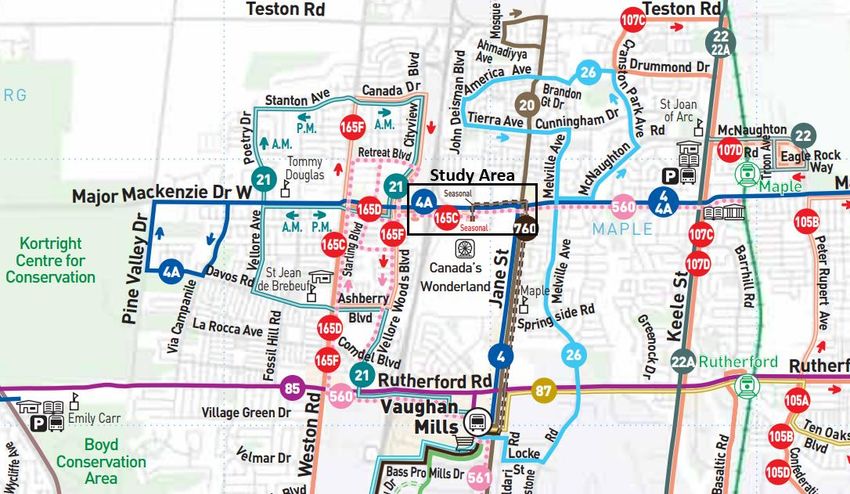
625 Cochrane Drive, Suite 500 ǀ Markham, Ontario L3R 9R9
                                                                   P: 905-943-0500 ǀ F: 905-943-0400 ǀ www.parsons.com

October 29, 2018
                                                                                                 Our Ref: [476323]

The Regional Municipality of York
17250 Yonge Street
Newmarket, ON, Canada
L3Y 6Z1

Re:        Major Mackenzie Drive Environmental Assessment – Active Transportation
           and Transit Facilities Assessment Memo

We are pleased to provide you (1) pdf copy of the completed Active Transportation and Transit Facilities
Assessment Memo as part of the Major Mackenzie Drive Class Environmental Assessment (EA) study between
Highway 400 and Jane Street.

If you would like any additional information or further clarifications on any aspect of our submission, please
contact the undersigned at 416-662-2045.

Yours truly,

Saad Syed, P.Eng.
Principal Project Manager

cc Andrew Evraire, BURPI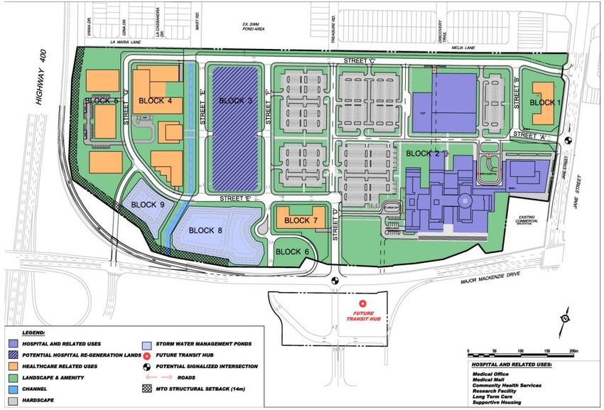
625 Cochrane Drive, Suite 500 ǀ Markham, Ontario L3R 9R9
                                                          P: 905-943-0500 ǀ F: 905-943-0400 ǀ www.parsons.com

Report Prepared By:

_________________________________
Andrew Evraire, BURPI
Planner

Report Reviewed By:

_________________________________
Saad Syed, P.Eng.
Principal Project Manager

                                     List of Revisions:

                   VERSION                DATE                        DESCRIPTION
                      1              August 17 2017           Draft for Internal Review
                      2             September 20 2017        Draft Submitted to Region
                      3              January 26 2018               Final Submission
                      4              October 29 2018             Clarifications Added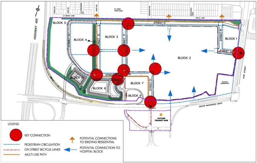
Table of Contents

EXECUTIVE SUMMARY................................................................................................................................................................... 1
1.     INTRODUCTION ..................................................................................................................................................................... 2
     1.1       STUDY AREA ................................................................................................................................................................. 2
2.     PEDESTRIAN FACILITIES ....................................................................................................................................................... 3
     2.1       EXISTING ...................................................................................................................................................................... 3
     2.2       PLANNED ...................................................................................................................................................................... 8
3.     CYCLING FACILITIES ...........................................................................................................................................................10
     3.1       EXISTING ....................................................................................................................................................................10
     3.2       PLANNED ....................................................................................................................................................................14
     3.3       DESIGN CRITERIA.......................................................................................................................................................15
     3.4       BEST PRACTICES........................................................................................................................................................17
4.     TRANSIT SERVICE AND FACILITIES ....................................................................................................................................18
     4.1       EXISTING ROUTES, FACILITIES AND CONNECTIONS ................................................................................................18
     4.2       EXISTING LEVEL OF SERVICE ....................................................................................................................................19
     4.3       PLANNED ROUTES, FACILITIES AND CONNECTIONS ...............................................................................................19
     4.4       DESIGN CRITERIA.......................................................................................................................................................21
5.     CONCLUSION ......................................................................................................................................................................21

     Major Mackenzie Drive Class EA – Active Transportation and Transit Facilities Assessment                                                                                             i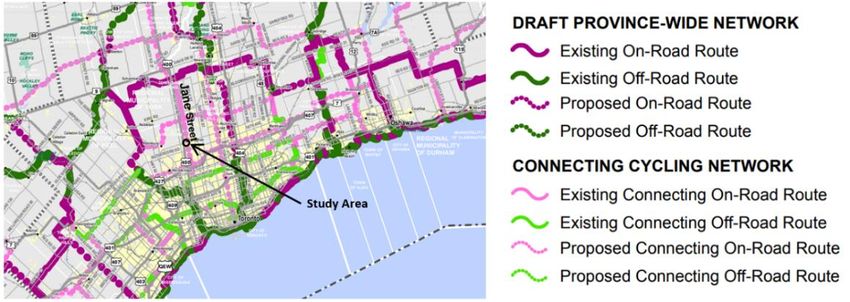
EXECUTIVE SUMMARY
This report presents an overview of existing and planned conditions for walking, cycling and transit facilities on
Major Mackenzie Drive between Highway 400 and Jane Street (Regional Road 55). This assessment has been
conducted as part of the on-going Environmental Assessment (EA) for potential roadway improvements on Major
Mackenzie Drive as identified in the 2016 York Region Transportation Master Plan (TMP).
Existing pedestrian facilities are provided primarily on the south side of Major Mackenzie Drive in the study area
and operate mostly at a Level of Service (LOS) B, with the north side operating mostly at an LOS E and F with a
lack of dedicated pedestrian facilities. Although the south side operates at an LOS B in some areas, there are
several gaps along the route and sidewalks within close proximity of Highway 400 are mostly asphalt and offer
limited crossing treatments at on-ramps to Highway 400.
Major Mackenzie Drive features a limited amount of existing cycling facilities and operates at a Level of Service
E and F for cyclists. There are some areas of the corridor where a paved shoulder is provided resulting in the
LOS E designation. Each of the four intersections within the study area do not include provisions for cyclists.
Existing transit service on Major Mackenzie Drive is provided by York Region Transit (YRT) Route 4A which is the
primary east-west regular service route in the study area. GO Transit route 66/66A uses a short section of Major
Mackenzie Drive to access the GO Transit terminal on the west side of Highway 400 when travelling between
Yorkdale Terminal and Newmarket. Additional seasonal transit service is provided by YRT and the Toronto
Transit Commission (TTC) to and from Canada’s Wonderland.
Major Mackenzie Drive is designated as a separated cycling facility route in the ten-year cycling network plan in
the TMP. This designation requires the provision of cycle tracks, raised bike lanes or multi-use trails along the
corridor. In addition, the Vaughan Healthcare Precinct Area (VHCP) currently under construction will provide a
sidewalk along the north side of Major Mackenzie Drive between Wellness Way and Jane Street which could be
incorporated during the EA design process. The TMP also identifies the completion of gaps in sidewalks as a
key “move” to support the integration of active transportation in urban areas.
West of Jane Street, within the 2016 TMP, Major Mackenzie Drive is designated as part of the Frequent Transit
Network (FTN) to be implemented by 2021. The FTN network is designed to offer service every 15 minutes or
less from 6:00am to 10:00pm, seven days a week. In the long term TMP transit network (beyond 2032), Major
Mackenzie Drive west of Jane street is identified as a potential rapid transit alignment subject to further study.
In addition to planned service increases in the long term and the potential inclusion of a rapid transit alignment
subject to further study, there are also plans for a transit terminal on the south side of Major Mackenzie Drive
as part of the Vaughan Healthcare Centre Precinct development. It is expected the terminal would be used by
several transit agencies and offer connections to the Healthcare Centre and Canada’s Wonderland.

   Major Mackenzie Class EA – Active Transportation and Transit Facilities Assessment                        1
1. INTRODUCTION
Parsons has been retained by the Regional Municipality of York to undertake a Municipal Class Environmental
Assessment (EA) study to identify and assess future roadway improvements for Major Mackenzie Drive (Regional
Road 25) between Highway 400 and Jane Street (Regional Road 55). Improvements for Major Mackenzie Drive
have been identified in the York Region Transportation Master Plan (TMP) and this project is included in the
York Region 2016 10-Year Roads and Transit Capital Construction Program.

The intention of the improvements will be to increase east-west lane capacity, improve connectivity and provide
mobility options for multiple modes of transportation including transit, cycling and walking. The York Region TMP
envisions this to be facilitated by widening the roadway from a 4-lane rural cross section to a 6-lane urban cross
section with active transportation facilities.

The purpose of this report is to review and evaluate existing and future conditions for cycling, pedestrian and
transit service throughout the Major Mackenzie Drive Study Area. Incorporating this report as part of the EA will
provide an understanding of existing challenges, opportunities and future requirements for these modes.
1.1 STUDY AREA
The project limits for the EA study include a 1.1km section of Major Mackenzie Drive from the Highway 400 full
moves interchange in the west to Jane Street (Regional Road 55) in the east. The study area corridor is currently
adjacent the future hospital, future transit hub and Canada’s Wonderland Amusement Park. The study area
limits are presented in Figure 1.0. Within the study area Major Mackenzie Drive is currently a four-lane east-
west urban arterial road which contains four signalized intersections.

                                   Figure 1.0 - Active Tranportation and Transit Analysis Study Area

   Major Mackenzie Class EA – Active Transportation and Transit Facilities Assessment                        2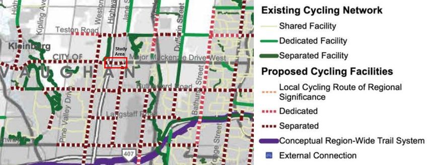
2. PEDESTRIAN FACILITIES
2.1 EXISTING
As a method of determining the condition and user experience of existing pedestrian facilities along Major
Mackenzie Drive in the Study Area, a Level of Service (LOS) assessment has been conducted based on the
criteria provided in the York Region Mobility Plan Guidelines, 2016. For mobility plan studies, the minimum
target is LOS C for pedestrian facilities.
                                             Table 2.0 – Pedestrian Level of Service Criteria

  LEVEL OF SERVICE                                SEGMENT                                             INTERSECTION

           A                  ≥2.0m sidewalk with minimum 3.5m                          •   ≥2.0m sidewalk with minimum 3.5m
                             buffer including planting and edge zone;                       buffer including planting and edge
                                      or ≥3.0m multi-use path                               zone; or ≥3.0m multi-use path
                                                                                        •   Pedestrian signal head with sufficient
                                                                                            pedestrian clearance time
                                                                                        •   Clearly delineated cross-walk
           B                   ≥1.5m sidewalk with minimum 1.0m                         •   ≥1.5m sidewalk with minimum 1.0m
                               buffer including edge zone; or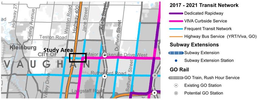
The figure and tables below illustrate the existing pedestrian Level of Service (LOS) on Major Mackenzie Drive
in the study area. Pedestrian facilities on the south side of Major Mackenzie Drive operate primarily at an LOS
B, with the north side operating mostly at an LOS E and F with a lack of dedicated pedestrian facilities. Although
the south side operates at an LOS B in some areas, there are several gaps along the route and sidewalks within
proximity of Highway 400 are mostly asphalt and offer limited crossing treatments at on-ramps to Highway 400.
Table 2.3 below provides an overview of existing conditions which complement the Level of Service assessment.
                                            Figure 2.1 – Existing Pedestrian Level of Service

                                      Table 2.1 – Existing Pedestrian Level of Service (Segments)

                                          SEGMENT                                                             PEDESTIRAN
                                                                                                DIRECTION
                    FROM                                               TO                                   LEVEL OF SERVICE
        GO Transit Park and Ride                           Hwy 400 SB On-Ramp                   Eastbound          C
          Hwy 400 SB On-Ramp                               Hwy 400 NB On-Ramp                   Eastbound          B
          Hwy 400 NB On-Ramp                               Hwy 400 NB Off-Ramp                  Eastbound          E
          Hwy 400 NB Off-Ramp                      Hwy 400 NB Off-Ramp, 30m East of             Eastbound          C
  Hwy 400 NB Off-Ramp, 30m East Of                  Coaster Way Bridge, 90m West of             Eastbound          B
   Coaster Way Bridge, 90m West of                            Amusement Drive                   Eastbound          F
            Amusement Drive                              Underpass (Closed) Bridge              Eastbound          C
       Underpass Bridge (Closed)                                  Jane Street                   Eastbound          B
                Jane Street                                  Coaster Way Bridge                 Westbound          F
           Coaster Way Bridge                              Hwy 400 SB On-Ramp                   Westbound          E
       Highway 400 SB On-Ramp                            Highway 400 SB Off-Ramp                Westbound          D

   Major Mackenzie Class EA – Active Transportation and Transit Facilities Assessment                                     4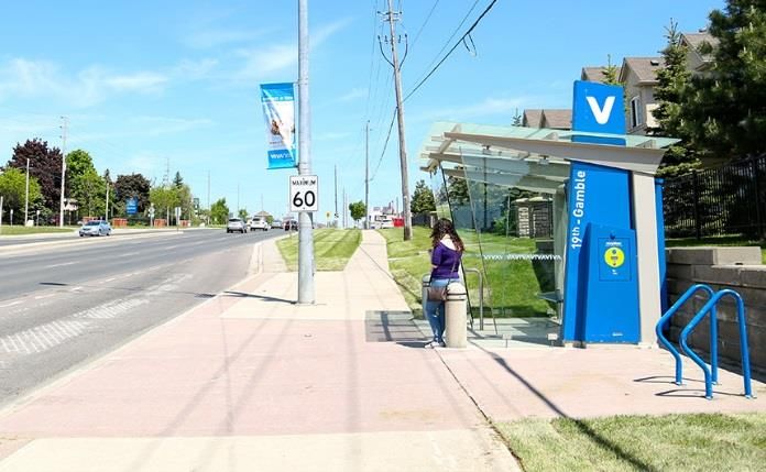
Table 2.2 – Existing Pedestrian Level of Service (Intersections)

                                                                                                                    PEDESTIRAN
              INTERSECTION                                DIRECTION                     SIDE OF INTERSECTION
                                                                                                                  LEVEL OF SERVICE
                                                          Northbound                            East                          E
   Major Mackenzie Drive / Hwy 400                       Southbound                            West                           C
   SB Off Ramp/GO Transit Park and
                Ride                                      Eastbound                            South                          C
                                                          Westbound                            North                          C
                                                          Northbound                            East                          F
        Major Mackenzie Drive /                          Southbound                            West                           F
         Hwy 400 NB Off-Ramp                              Eastbound                            South                          C
                                                          Westbound                            North                      N/A
                                                          Northbound                            East                          C
      Major Mackenzie Drive /                            Southbound                            West                           F
   Amusement Drive / Wellness Way                         Eastbound                            South                          B
                                                          Westbound                            North                          F
                                                          Northbound                            East                          C
     Major Mackenzie Drive / Jane                        Southbound                            West                           C
               Street                                     Eastbound                            South                          B
                                                          Westbound                            North                          C

As shown in Table 2.3, sidewalks located in proximity of Highway 400 are made of asphalt and provide limited
buffer space from general traffic. Pedestrians walking on Major Mackenzie Drive are positioned next to fast
moving traffic entering on to Highway 400 on both the north and south sides. The current roadway configuration
requires pedestrians to yield to vehicles entering highway 400 where there are no clearly marked pedestrian
crossings. Most pedestrian facilities on the south side of Major Mackenzie Drive are 1.5 meters in width, which
may not be sufficient space for passing other sidewalk users.

                         Table 2.3 – Overview of Existing Pedestrian Conditions on Major Mackenzie Drive
                                            Location: East of Highway 400 NB On-Ramp, south side, looking east

                                            Condition: Asphalt strip at a width of 1.2 metres. Does not provide an adequate
                                            pedestrian facility.

                                            Level of Service along Segment: E

                                            Location: West Highway 400 SB On-Ramp, south side, looking east

                                            Condition: Asphalt sidewalk at a width of 1.7 metres. Provides somewhat adequate
                                            pedestrian facility although there is no buffer space between vehicles and pedestrians.

                                            Level of Service along Segment: C

   Major Mackenzie Class EA – Active Transportation and Transit Facilities Assessment                                                 5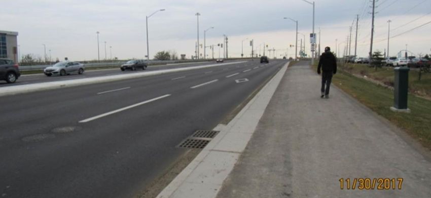
Location: Highway 400 Bridge, south side, looking east

                                            Condition: Concrete sidewalk at a width of 1.9 metres with additional 2.0m buffer
                                            provided by edge space. Provides adequate pedestrian facility.

                                            Level of Service along Segment: B

                                            Location: East of Highway 400 NB Off Ramp Signalized Intersection, south side, looking
                                            east

                                            Condition: Concrete sidewalk at same grade as roadway. Width of 1.5 metres with
                                            additional buffer space provided by adjacent paved shoulder. Provides somewhat
                                            adequate pedestrian facility although there is no physical separation between vehicles
                                            and cyclists.

                                            Level of Service along Segment: B

                                            Location: Approach to Coaster Way Bridge, south side, looking east

                                            Condition: Pedestrian facilities are not provided.

                                            Level of Service along Segment: F

                                            Location: Approach to Highway 400 overpass, north side, looking west

                                            Condition: Pedestrian facilities are not provided.

                                            Level of Service along Segment: F

                                            Location: Eastbound On-Ramp to Southbound Highway 400, south side, looking east

                                            Condition: Curb depressions are provided for existing asphalt sidewalks.

Based on available turning movement count data from 2016, pedestrian volumes on Major Mackenzie Drive
through the study area are relatively limited, with most pedestrian activity taking place near the Jane Street
intersection. On the south side of Major Mackenzie Drive where there are limited segments of pedestrian
facilities, east-west pedestrian traffic was approximately 20 pedestrians during the hours of 7am to 6pm based
on a sample from November 2016.

   Major Mackenzie Class EA – Active Transportation and Transit Facilities Assessment                                                6
Table 2.4. – Existing Pedestrian Volumes at Intersections
DIRECTION OF SIDE OF PEDESTRIAN
INTERSECTION DATE AND TIME PERIOD
TRAVEL INTERSECTION VOLUME
Nov 17 2016 – 7am to 6pm North-South West 1
Major Mackenzie
Drive / Hwy 400 SB Nov 17 2016 – 7am to 6pm North-South East 0
Off Ramp/GO Transit Nov 17 2016 – 7am to 6pm East-West North 1
Park and Ride
Nov 17 2016 – 7am to 6pm East-West South 25
Nov 17 2016 – 7am to 6pm North-South West 0
Major Mackenzie
Drive / Nov 17 2016 – 7am to 6pm North-South East 0
Hwy 400 NB Off- Nov 17 2016 – 7am to 6pm East-West North 0
Ramp
Nov 17 2016 – 7am to 6pm East-West South 22
Nov 17 2016 – 7am to 6pm North-South West 0
Major Mackenzie Nov 17 2016 – 7am to 6pm North-South East 5
Drive / Amusement
Drive / Wellness Way Nov 17 2016 – 7am to 6pm East-West North 0
Nov 17 2016 – 7am to 6pm East-West South 17
Nov 23 2016 – 7am to 6pm North-South West 14
Major Mackenzie Nov 23 2016 – 7am to 6pm North-South East 133
Drive / Jane Street Nov 23 2016 – 7am to 6pm East-West North 20
Nov 23 2016 – 7am to 6pm East-West South 17
Source: November 2016 TMC Counts, York Region
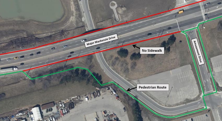
Major Mackenzie Class EA – Active Transportation and Transit Facilities Assessment 7Pedestrian facilities are primarily located on the south side of Major Mackenzie Drive only, providing a less direct
connection for pedestrians accessing land uses on the north side which will include the new hospital (currently
under construction). As illustrated in Figure 2.2, on the south side of Major Mackenzie Drive, there are missing
sidewalk links which require pedestrians to detour onto Amusement Drive rather than continue straight on Major
Mackenzie Drive.
Figure 2.2 – Example of Major Mackenzie Drive Pedestrian Facility Gap
Historic collision data for Major Mackenzie Drive within the study area indicates 17 pedestrian collisions
occurred between 2006 and 2016. Three of these incidents were at the Highway 400 interchange and 14 were
at the intersection of Major Mackenzie Drive and Jane Street. The majority of these collisions occurred where
pedestrians crossed with right of way.
2.2 PLANNED
The 2016 York Region TMP states “fixing discontinuous sidewalks will encourage walking trips” and identifies
the completion of gaps in sidewalks as one of the TMP’s “Big Moves” to support the integration of active
transportation in Urban Areas. As illustrated in the 2016 TMP in Figure 2.3 and confirmed from the LOS analysis
for existing conditions, Major Mackenzie Drive is currently shown to have missing or partial pedestrian facilities.
As Major Mackenzie Drive is located within the Urban Boundary, addressing these sidewalk gaps would meet
the objectives of the TMP of supporting the integration of active transportation in Urban Areas.
Major Mackenzie Class EA – Active Transportation and Transit Facilities Assessment 8Figure 2.3 – Sidewalk Gaps on Regional Roads – 2016 York Region TMP
In addition to the policy objectives provided in the TMP, the Vaughan Healthcare Centre Area will add several
new pedestrian connections in the study area, including pedestrian facilities on the north side of Major
Mackenzie Drive between Wellness Way and Jane Street. This planned addition of pedestrian facilities along
Major Mackenzie Drive could be accommodated during the EA design process for potential roadway
improvements along this segment. Details of the most recent site plan (currently in draft format) will be
confirmed during the design phase for this segment to ensure compatibility with the recommended EA design.
Figure 2.4 - Vaughan Healthcare Precinct Plan (Pedestrian and Cycling Connections)
Source: Final Vaughan Healthcare Centre Precinct Plan as Endorsed by Council in November 2013
Major Mackenzie Class EA – Active Transportation and Transit Facilities Assessment 93. CYCLING FACILITIES
3.1 EXISTING
Using a similar method of determining the condition and user experience of existing pedestrian facilities along
Major Mackenzie Drive in the study area, a Level of Service (LOS) assessment has also been conducted for
cycling facilities based on the criteria provided in the York Region Mobility Plan Guidelines, 2016. For mobility
plan studies, the minimum target is LOS C for cycling facilities.
Table 3.0 – Bicycle Level of Service Criteria
LEVEL OF SERVICE SEGMENT INTERSECTION
A Separated cycling facilities Separated cycling facilities, Bicycle box
(e.g. cycle tracks, multi-use path) or clearly delineated bicycle treatment
or bicycle signal head
B ≥1.8m dedicated cycling facilities >1.8 m dedicated cycling facilities
(e.g. bicycle lanes with and without (e.g. bicycle lanes with and without
buffer) buffer), Bicycle box, clearly delineated
bicycle treatment or bicycle signal head
CFigure 3.0 – Existing Paved Shoulder for Cyclists – East of Highway 400 Northbound Off-Ramp, South Side Looking East
Figure 3.1 – Existing Bicycle Level of Service
Table 3.1 – Existing Bicycle Level of Service (Segments)
SEGMENT BICYCLE
DIRECTION
FROM TO LEVEL OF SERVICE
GO Transit Park and Ride Hwy 400 SB On-Ramp Eastbound F
Hwy 400 SB On-Ramp Hwy 400 NB On-Ramp Eastbound E
Hwy 400 NB On-Ramp Hwy 400 NB Off-Ramp, 30m East of Eastbound F
Hwy 400 NB Off-Ramp, 30m East of Coaster Way Bridge, 90m West of Eastbound E
Coaster Way Bridge, 90m West of Jane Street Eastbound F
Jane Street Coaster Way Bridge Westbound F
Coaster Way Bridge West Side of Hwy 400 NB On-Ramp Westbound E
West Side of Hwy 400 NB On-Ramp 20m further west Westbound F
20m further west of Hwy 400 NB
Hwy 400 SB On-Ramp Westbound E
On-Ramp
Hwy 400 SB On-Ramp Hwy 400 SB Off-Ramp Westbound F
Major Mackenzie Class EA – Active Transportation and Transit Facilities Assessment 11Table 3.2 – Existing Bicycle Level of Service (Intersections)
BICYCLE LEVEL
INTERSECTION DIRECTION SIDE OF INTERSECTION
OF SERVICE
Northbound East F
Major Mackenzie Drive / Hwy 400 Southbound West F
SB Off Ramp/GO Transit Park and
Ride Eastbound South F
Westbound North F
Northbound East F
Major Mackenzie Drive / Southbound West F
Hwy 400 NB Off-Ramp Eastbound South F
Westbound North N/A
Northbound East F
Major Mackenzie Drive / Southbound West F
Amusement Drive / Wellness Way Eastbound South F
Westbound North F
Northbound East F
Major Mackenzie Drive / Jane Southbound West F
Street Eastbound South F
Westbound North F
Immediately west of the study area, there is a new multi-use pathway on the south side of Major Mackenzie
Drive, terminating at the signalized access to the existing GO Transit Park and Ride Lot (Figure 3.2).
Opportunities to connect with this existing facility on the south side should be identified during the EA design
process.
Figure 3.2 – Multi Use Trail on South Side of Major Mackenzie Drive, West of GO Transit Park and Ride
Major Mackenzie Class EA – Active Transportation and Transit Facilities Assessment 12Based on available turning movement count data from a sample in November 2016, cycling volumes on Major
Mackenzie Drive through the study area are very limited, with less than 5 east-west movements occurring at
most intersections during a full sample period of 7:00am to 6:00pm. Cyclists volumes may be higher during the
summer months.
Table 3.3 – Existing Cycling Volumes at Intersections
APPROACH / CYCLIST
INTERSECTION DATE AND TIME PERIOD
MOVEMENT VOLUME
Nov 17 2016 – 7am to 6pm Thru 4
EB
Nov 17 2016 – 7am to 6pm Right 1
Nov 17 2016 – 7am to 6pm Left 0
Major Mackenzie WB
Nov 17 2016 – 7am to 6pm Thru 1
Drive / Hwy 400 SB
Nov 17 2016 – 7am to 6pm Left 0
Off Ramp/GO Transit NB
Park and Ride Nov 17 2016 – 7am to 6pm Right 0
Nov 17 2016 – 7am to 6pm Left 0
Nov 17 2016 – 7am to 6pm SB Thru 0
Nov 17 2016 – 7am to 6pm Right 0
Nov 17 2016 – 7am to 6pm EB Thru 3
Major Mackenzie Nov 17 2016 – 7am to 6pm WB Thru 2
Drive /
Hwy 400 NB Off-Ramp
Nov 17 2016 – 7am to 6pm Left 0
NB
Nov 17 2016 – 7am to 6pm Right 1
Nov 17 2016 – 7am to 6pm Thru 2
EB
Nov 17 2016 – 7am to 6pm Right 0
Major Mackenzie Nov 17 2016 – 7am to 6pm Left 1
WB
Drive / Amusement Nov 17 2016 – 7am to 6pm Thru 2
Drive / Wellness Way Nov 17 2016 – 7am to 6pm Left 0
Nov 17 2016 – 7am to 6pm SB Thru 0
Nov 17 2016 – 7am to 6pm Right 0
Nov 23 2016 – 7am to 6pm Left 0
Nov 23 2016 – 7am to 6pm EB Thru 2
Nov 23 2016 – 7am to 6pm Right 0
Nov 23 2016 – 7am to 6pm Left 0
Nov 23 2016 – 7am to 6pm WB Thru 2
Major Mackenzie Nov 23 2016 – 7am to 6pm Right 0
Drive / Jane Street Nov 23 2016 – 7am to 6pm Left 0
Nov 23 2016 – 7am to 6pm NB Thru 0
Nov 23 2016 – 7am to 6pm Right 5
Nov 23 2016 – 7am to 6pm Left 0
Nov 23 2016 – 7am to 6pm SB Thru 0
Nov 23 2016 – 7am to 6pm Right 0
Source: November 2016 TMC Counts, York Region.
Major Mackenzie Class EA – Active Transportation and Transit Facilities Assessment 13Historic collision data for Major Mackenzie Drive within the study area indicates 5 bicycle collisions occurred
between 2006 and 2016. Three of these incidents were at the Highway 400 S-EW off-ramp and two were at the
intersection of Major Mackenzie Drive and Jane Street.
3.2 PLANNED
As shown in Figure 3.3, the 2016 York Region Transportation Master Plan (TMP) designates Major Mackenzie
Drive as a “separated” cycling facility as part of the “10-year Cycling Network”. The 10-year Cycling Network is
intended to be implemented through approved capital projects identified over a short-term horizon. The TMP
defines separated cycling facilities as routes which may consistent of “cycle tracks, raised bike lanes or multi-
use trails”. The TMP envisions these facilities to be located on higher-speed, busy roadways.
Figure 3.3 – Ten Year Cycling Network – 2016 York Region TMP
East of Jane Street, Major Mackenzie Drive is identified as a separated facility as part of the 2041 (Ultimate)
Cycling Network in the TMP, which is intended to be implemented as opportunities arise which may not be
identified as part of existing planned capital projects.
On the eastern side of the study area, Jane Street is identified as a separated cycling facility in the 2016 TMP
and a “Proposed Connecting On-Road Route” in the Draft 2017 Provincial Cycling Network Plan. Separated
cycling facilities on Major Mackenzie Drive as identified in the 2016 York Region TMP would provide a
connection to this facility. It is Parsons understanding that off-road facilities are currently being considered for
Jane Street by the City of Vaughan. Information pertaining to planned facilities on Jane Street will be confirmed
and considered as the design for the corridor progresses.
Major Mackenzie Class EA – Active Transportation and Transit Facilities Assessment 14Figure 3.5 – 2017 Draft Province-Wide Cycling Network (Toronto Area) Improvements are currently planned for the Metrolinx Park and Ride on the south side of Major Mackenzie Drive, west of Highway 400. The intent of the improvements will be to reconfigure the existing site within current property limits. Improvements will be made to parking, bus loop design, bike storage, and bus platforms. As part of these improvements, it may be possible to provide a direct Active Transportation link leading to the bus platform. A link could be provided on the west or east side of the site entrance, however the east side is preferred as this would provide a connection leading directly to the bus platform. Potential designs to accommodate for this link will be coordinated with Metrolinx as the study progresses. 3.3 DESIGN CRITERIA Regional Standards Based on the separated cycling facility designation in the TMP, the addition of cycling facilities on Major Mackenzie Drive would need to consist of cycle tracks, raised bike lanes or multi use trails. With this requirement, facilities will need to be provided on both sides of the road (one way facilities) or on one side (a two-way facility). As Major Mackenzie Drive is a regional road, York Region design standards will apply for the addition of cycling facilities. The standard lane widths for cycling facilities provided in the York Region Road Design Guidelines is 2.0m (1.5m cycling lane with 0.5m buffer). The guidelines also identify a Multi Use pathway width of 3.0m, however this is often seen as a minimum standard, and a desirable range is between 3.0 to 4.0 metres as per OTM Book 18 guidelines. MTO Standards An additional consideration for providing cycling facilities on Major Mackenzie Drive includes provincial design standards at the Highway 400 interchange. The 2014 MTO Bikeway Design Guidelines present several design options for both on-road and off-road facilities. To mitigate conflict at on-ramps, the guidelines present alternative options for improving the visibility of cyclists, as shown below: Major Mackenzie Class EA – Active Transportation and Transit Facilities Assessment 15
Figure 3.6 – Examples of Design Treatments at Highway On-Ramps

    Context Specific Design for a Bicycle Lane Carried Straight-                    Bicycle Lane Jug Handle at High Speed Diverging Ramp
              Across a Lower Speed Diverging Ramp

The guidelines state that “when an AT path or off-road multi-use trail is to cross a 400 Series or similar high
speed provincial highway in the vicinity of an interchange, designers should investigate providing a separate
dedicated pedestrian/cyclist crossing/bridge up or downstream of the interchange to avoid any conflicts with
the interchange ramps.” Despite these guidelines, it is unlikely a separate bridge structure could be included
within the current project scope. As an alternative, the guideline also states that a design option may “consider
bringing the AT path or off-road multi-use trail up to the interchange area and have the path or trail cross the
ramps and the interchange structure in place of a sidewalk. There should be sufficient space to accommodate
the two-way, shared use facility and an appropriate buffer or “splash pad” width separating the shared use
facility and the vehicular travelled portion of the roadway. If a sufficient buffer or “splash pad” width cannot be
provided, designers may consider a barrier to provide separation of the two-way, shared use facility and the
roadway.” The following cross section would be applicable on the bridge deck using a concrete barrier treatment
to provide a buffer between facility users and travel lanes in order to provide a high level of user comfort.

                     Figure 3.7 - Structure Cross-Section with Signed Bicycle Facility on Designated Cycling Route

Notes:
3. Traffic Barrier unless shoulder(s) are designated and signed for use by cyclists on structure, in which case Combination Traffic/Bicycle Barrier
4. Traffic Barrier
5. Combination Pedestrian/Bicycle Barrier. Minimum railing height is 1.37m to accommodate Active Transportation users.

    Major Mackenzie Class EA – Active Transportation and Transit Facilities Assessment                                                                16
3.4 BEST PRACTICES
Building upon the minimum design criteria provided in the York Region Road Design Guidelines, cycling facilities
on Major Mackenzie Drive may also include other features such as signalized crossrides at intersections. Ontario
Traffic Manual Book 18 (OTM Book 18) and other resources such as the Global Street Design Guidelines provide
design guidance for these treatments.
Figure 3.8 – Suggested Widths for Separated Cycling Facilities (OTM Book 18)
Figure 3.9 – Examples of Intersection Crossing Treatments (OTM Book 18 + Global Street Design Guidelines)
At a minimum, it is recommended that a Separated Crossride (as shown in the first image of Figure 3.9 above)
be provided at intersections in order for cyclists to continue through intersections without having to “dismount
and walk”. A separated crossride provides clarity for users at an intersection and is typically easier to signalize.
Providing an increased offset between turning motorists and passing cyclists would also provide greater sight
lines to improve safety. The protected intersection concept as shown in the third image above could also be
applied to areas where cycling facilities will intersect with other routes or provide a link to key destinations such
as the Vaughan Healthcare Site and Canada’s Wonderland. The protected intersection concept has been
adopted in several projects in the Ontario context such as in the City of Ottawa and can be applied to a wide
range of road and facility types.
Major Mackenzie Class EA – Active Transportation and Transit Facilities Assessment 174. TRANSIT SERVICE AND FACILITIES
4.1 EXISTING ROUTES, FACILITIES AND CONNECTIONS
The figure below presents the existing transit service on Major Mackenzie Drive in the study area. Bus routes
4A, 165C, 560 and 760 traverse the corridor where improvements could be taking place. GO Transit Route
66/66A also uses a short section of Major Mackenzie Drive when coming from Highway 400 to access the GO
Transit Park and Ride facility on the west side of Highway 400.
Figure 4.0 – Existing Transit Service within Study Area
Source: 2017 York Region Transit Map
Transit stops on Major Mackenzie Drive within the study area are located at the Wellness Way/Amusement
Drive and Jane Street. At Wellness Way and Amusement Drive, transit stops include a wide platform and
provisions for future transit shelter installations. At Jane Street, transit stops also include a wide platform and
feature decorative transit shelters.
Figure 4.1 – Existing Transit Stops at Amusement Drive/Wellness Way (Left) and Jane Street (Right)
Major Mackenzie Class EA – Active Transportation and Transit Facilities Assessment 184.2 EXISTING LEVEL OF SERVICE
Table 4.0 below provides existing frequencies during rush hour. Route 4A Major Mackenzie is the regular service
YRT route which services the corridor, with additional routes by YRT and the TTC offering seasonal service to
Canada’s Wonderland. GO Transit Route 66/66A offers regular service between Yorkdale Terminal and
Newmarket, making a stop at the existing GO Transit terminal on the west side of Highway 400.
Table 4.0 – Existing Transit Service and Rush Hour Frequency
ROUTE OPERATED BY EXISTING RUSH HOUR FREQUENCY
4A Major York Region Transit
Approximately every 30 minutes
Mackenzie (YRT)
560 Maple York Region Transit
Thursdays only during off-peak times
Community Bus (YRT)
760 Canada’s York Region Transit Hourly during PM peak period in summer months
Wonderland (YRT) (July to September)
165C Weston Rd Toronto Transit N/A - Seasonal Route – Weekends and Holidays
North Commission Only
66/66A SB: Approximately every 20 minutes
Newmarket/North GO Transit
York Express NB: Approximately every hour
All existing transit service on Major Mackenzie Drive in the study area operates in mixed traffic conditions,
resulting in similar levels of delay for vehicles on the corridor. Information on existing traffic conditions is
provided in the Draft Transportation and Traffic Analysis Report submitted to York Region in September 2017.
4.3 PLANNED ROUTES, FACILITIES AND CONNECTIONS
In the 2016 TMP, Major Mackenzie Drive in the study area is designated as part of the Frequent Transit Network
(FTN) to be implemented by 2021. The FTN network is designed to offer service every 15 minutes or less from
6:00am to 10:00pm, seven days a week. The initial phase of the FTN (2016 to 2020) would offer frequent
service during rush hours only. As per the 2016-2026 York Region Transit (YRT)/VIVA Strategic Plan, Major
Mackenzie Drive in the study area is scheduled operate at FTN levels by 2016 during rush hours only, however
existing rush hour service is still provided at approximately 30 minute intervals.
Figure 4.2 – 2017-2021 Transit Network (2016 York Region TMP)
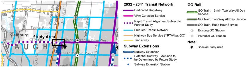
Major Mackenzie Class EA – Active Transportation and Transit Facilities Assessment 19In the long term TMP transit network (beyond 2032), Major Mackenzie Drive in the study area is identified as a
potential rapid transit alignment subject to further study.
Figure 4.3 – 2032-2041 Transit Network (2016 York Region TMP)
In addition to planned service increases in the long term and the potential inclusion of a rapid transit alignment
subject to further study, there are also plans for a transit terminal on the south side of Major Mackenzie Drive
in the study area as part of the Vaughan Healthcare Centre Precinct Plan (Figure 4.4). It is expected the terminal
would be used by several transit agencies in the Region and offer connections to the Healthcare Center and
Canada’s Wonderland.
The final arrangement of the transit hub on the south side of Major Makenzie Drive has not yet been determined,
however the EA study process should consider the needs of the future terminal, such as access to and from
Major Mackenzie Drive by transit vehicles and pedestrian/cycling access from the corridor.
Figure 4.4 – Potential Future Transit Terminal Location – Vaughan Healthcare Centre Precinct Plan
Source: Final Vaughan Healthcare Centre Precinct Plan as Endorsed by Council in November 2013
Major Mackenzie Class EA – Active Transportation and Transit Facilities Assessment 204.4 DESIGN CRITERIA
York Region Transit (YRT) identifies design standards for transit stops for non-viva service which are to be
considered as part of the EA when designing new or improved transit stops. Subject to further review with YRT
staff during the EA design stage, transit stops along the corridor could feature transit shelters using standard
designs as provided in the “York Region Transit – Drawings and Specifications” criteria (2014).
Figure 4.5 –YRT Curbside Stop Design (With Bench)
Subject to further review as specified in the TMP, if Major Mackenzie Drive were to include Rapid Transit service
in the future, curbside transit shelters could be upgraded to a VIVA curbside stop design.
Figure 4.6 –YRT VIVA Curbside Stop Design
5. CONCLUSION
This report has reviewed and evaluated existing and future conditions for cycling, pedestrian and transit service
throughout the Major Mackenzie Drive Study Area. Incorporating this report as part of the EA provides an
understanding of existing challenges, opportunities and future requirements for these modes. Initiatives
currently underway such as the Vaughan Healthcare Centre provide opportunities to capitalize on existing plans
for new active transportation and transit facilities. Applying policies in the TMP and further considering best
practices for Active Transportation design will contribute to an enhancement of these modes of transportation
on Major Mackenzie Drive.
Major Mackenzie Class EA – Active Transportation and Transit Facilities Assessment 21You can also read