A review of the ocean-atmosphere interactions during tropical cyclones in the north Indian Ocean
←
→
Page content transcription
If your browser does not render page correctly, please read the page content below
preprint https://arxiv.org/abs/2012.04384

A review of the ocean-atmosphere interactions during
tropical cyclones in the north Indian Ocean

Vineet Kumar Singh1,2 and M.K. Roxy1*

1
 Indian Institute of Tropical Meteorology, Ministry of Earth Sciences, Pune, India
2
 Department of Atmospheric and Space Sciences, Savitribai Phule Pune University, Pune, India

Earth Science Reviews, submitted on 9 November 2020, Revised on 31 July 2021

*Corresponding author address: Roxy Mathew Koll, Indian Institute of Tropical Meteorology,
Pune 411008, India. E-mail: roxy@tropmet.res.in

 1
preprint https://arxiv.org/abs/2012.04384
Abstract
The north Indian Ocean accounts for 6% of the global tropical cyclones annually. Despite the small

fraction of cyclones, some of the most devastating cyclones have formed in this basin, causing

extensive damage to the life and property in the north Indian Ocean rim countries. In this review

article, we highlight the advancement in research in terms of ocean-atmosphere interaction during

cyclones in the north Indian Ocean and identify the gap areas where our understanding is still

lacking.

 There is a two-way ocean-atmosphere interaction during cyclones in the north Indian

Ocean. High sea surface temperatures (SSTs) of magnitude 28–29°C and above provide favorable

conditions for the genesis and evolution of cyclones in the Arabian Sea and the Bay of Bengal. On

the other hand, cyclones induce cold and salty wakes with SST cooling of 2–3°C during the pre-

monsoon season and 0.5–1°C during the post-monsoon season. This varying response in the two

seasons in the Bay of Bengal is due to the difference in the ocean haline stratification, whereas, in

the Arabian Sea it is due to the difference in cyclone wind power input and ocean thermal

stratification. Cyclone induced cooling depends on the translation speed of the cyclone, wind

power input, ocean stratification, and the subsurface conditions dictated by the ocean eddies,

mixed layer and the barrier layer in the north Indian Ocean. The oceanic response to cyclone is

asymmetric due to the asymmetry in the cyclone induced rainfall and the dynamics of the ocean

inertial currents. The cyclone induced wake is salty and is the saltiest in the Bay of Bengal among

all the ocean basins. The physical response of the ocean to the cyclone is accompanied by a

biological response also, as cyclones induce large chlorophyll blooms in the north Indian Ocean

that last from several days to weeks.

 2
preprint https://arxiv.org/abs/2012.04384
 Recent studies show that rapid warming in the north Indian Ocean associated with global

warming enhances the heat flux from the ocean to the atmosphere, and is fueling a rapid

intensification of these cyclones. SSTs leading to cyclogenesis in the Arabian Sea are 1.2–1.4°C

higher in the recent decades, compared to SSTs four decades ago. Changes in ocean-cyclone

interactions are emerging in recent decades in response to Indian Ocean warming, and are to be

closely monitored since future climate projections demonstrate continued warming of the Indian

Ocean at a rapid pace along with an increase in the intensity of cyclones in this basin.

 3
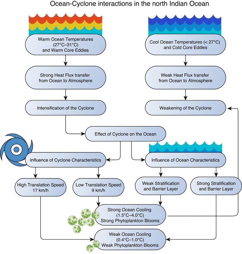
preprint https://arxiv.org/abs/2012.04384
1. Introduction

1.1. Overview of ocean-cyclone interactions

Tropical cyclones genesis and intensification occur mainly over the regions where the sea surface

temperatures (SSTs) are greater than 26ºC, mid-tropospheric humidity is high, and vertical wind

shear is low (Gray 1968). The ocean plays a dominant role in providing energy to the tropical

cyclone through the exchange of latent and sensible heat fluxes between the ocean and the

atmosphere (Ooyama 1969; Emanuel 1986; Vinod et al. 2014). Increased latent heat flux from the

ocean to the atmosphere moistens the boundary layer and provides conducive conditions for

cyclogenesis (Gao et al. 2019). The increased latent heat flux also plays a crucial role in cyclone

intensification (Gao and Chiu 2010; Lin et al. 2014; Jaimes et al. 2015; Gao et al. 2016). There is

a two-way interaction between SSTs and tropical cyclones (Emanuel 1986). SSTs significantly

modulate the cyclone intensity (Kaplan and DeMaria 2003). High SSTs, favor an increase in the

intensity of tropical cyclones through heat flux transfer from the ocean to the atmosphere (Emanuel

1986). On the other hand, the cyclone passage across the ocean leads to a decrease in the SSTs,

which in turn reduces the cyclone intensity due to a reduction in the transfer of heat flux from the

ocean to the atmosphere (DeMaria and Kaplan 1999; Cione and Uhlhorn 2003; Lloyd and Vecchi

2011). Cyclone induced cooling not only affects the intensity of cyclone but also has a pronounced

effect on the cyclone size (Chen et al. 2010; Ma et al. 2013) and structure (Zhu et al. 2004; Chen

et al. 2010). Cyclone cools the ocean by multiple processes, such as friction-induced vertical

mixing due to the high wind speed of cyclone, upwelling of cool subsurface water to the ocean

surface, internal waves in the ocean due to tropical cyclone winds (Brooks 1983; Shay and Elsberry

1987) and air-sea heat fluxes (Shen and Ginis 2003). Earlier studies for different ocean basins have

shown that out of the different processes associated with the cyclone induced cooling, the vertical

 4
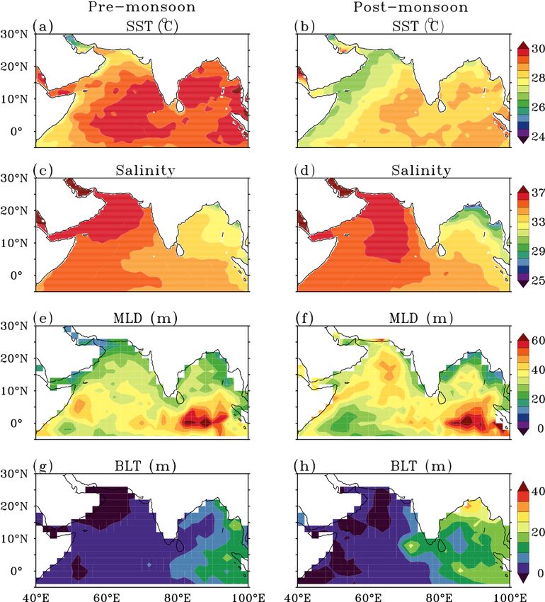
preprint https://arxiv.org/abs/2012.04384
mixing associated cooling dominates, with a share of 70-80% (Price 1981; Jullien et al. 2012;

Vincent et al. 2012a). On the other hand, the cooling due to horizontal advection and enthalpy flux

contributes only about 20% (Shay et al. 1992; Huang et al. 2009; Vincent et al. 2012a). For weak

cyclones, the contribution of the enthalpy flux in the cooling is larger than the vertical mixing

(Vincent et al. 2012a).

 The effect of the ocean-cyclone interaction on the cyclone track is yet to be clearly

understood. A few studies highlight that ocean-cyclone interaction improve the realistic

representation of the cyclone track in the model and improve the climatological representation of

cyclone tracks (Subrahmanyam et al. 2005; Jullien et al. 2014; Ogata et al. 2015). Whereas other

studies show that the tracks of the cyclones are generally not affected by the ocean-cyclone

coupling (Zhu et al. 2004; Chen et al. 2010; Liu et al. 2011).

1.2. Characteristics of the north Indian Ocean controlling the ocean-cyclone interactions

As seen from the earlier discussion, multiple factors control the ocean-cyclone interaction which

is dependent on cyclone and ocean characteristics. The north Indian Ocean sees significant

seasonal variations in the SST, salinity, the mixed layer and the barrier layer (Figure 1). In the pre-

monsoon season, the SSTs throughout the north Indian Ocean are high of the order of 29-30°C

(Figure 1a). Whereas, in the post-monsoon season, the SSTs are roughly 1°C cooler than the pre-

monsoon season (Figure 1b). Similarly, salinity also has a seasonality variation especially in the

Bay of Bengal (Figure 1c-d). In the post-monsoon season, the Bay of Bengal has low salinity in

the northeast part and high salinity in the southwest part of the basin (Rao and Sivakumar 2003).

The low salinity in the northern part of the Bay of Bengal in this season is mainly due to the oceanic

 5
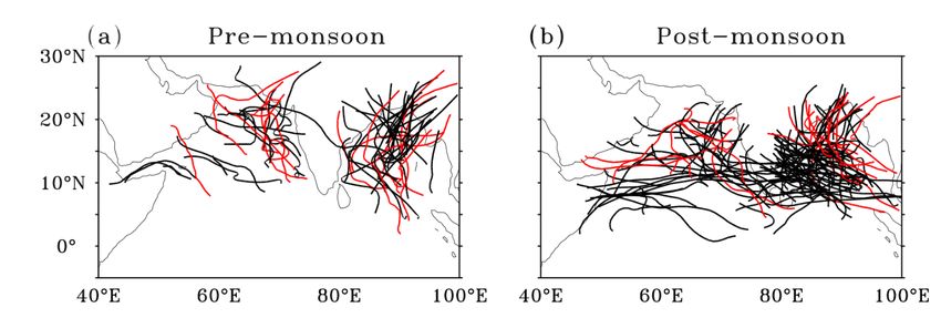
preprint https://arxiv.org/abs/2012.04384
rainfall and the huge river discharge into the northern Bay of Bengal (Shetye et al. 1996; Shenoi

2002; Sengupta et al. 2006; Akhil et al. 2014; Chaitanya et al. 2014). It leads to the formation of a

very strong near-surface halocline along the rim of the Bay of Bengal during the post-monsoon

season. Due to the presence of freshwater at the surface, the mixed layer becomes shallower

(Figure 1f). This enhances the ocean stratification with freshwater at the surface and saline water

in the subsurface (Vinayachandran et al. 2002) leading to the formation of a strong barrier layer

(Figure 1h) (Thadathil et al. 2007). This seasonal variation of barrier layer is absent in the Arabian

Sea. However, the mixed layer depth in the Arabian Sea shows large seasonal variations as

compared to the Bay of Bengal (Figure 1e-1f) (Shenoi 2002; Prasad 2004; Babu et al. 2004;

Narvekar and Prasanna Kumar 2006). The lack of seasonal variability in the mixed layer is mainly

observed in the north Bay of Bengal due to haline stratification. In the south Bay of Bengal the

mixed layer depth shows seasonal variability with a deep mixed layer in the monsoon and winter

season and a shallow mixed layer in the spring and autumn season. All these ocean characteristics

have a pronounced impact on the ocean-cyclone interaction as will be discussed later.

1.3.Statistics of cyclone in the north Indian Ocean

The north Indian Ocean, including the Arabian Sea and the Bay of Bengal, has two cyclone seasons

in a year, during April–June (pre-monsoon season), and October–December (post-monsoon

season). Cyclones, generally do not form in the monsoon season due to the strong wind shear

prevailing in this season (Li et al. 2013). The north Indian Ocean accounts for 6% of the tropical

cyclones globally (Figure 2, Neumann 1993; Ali 1999). Despite the relatively smaller number of

cyclones, more than 80% of global fatalities occur due to tropical cyclones in this region, mostly

due to coastal flooding (Beal et al. 2020). Several of the most devastating cyclones that formed in
 6
preprint https://arxiv.org/abs/2012.04384
the Bay of Bengal caused extensive casualties in the Bay of Bengal rim countries, particularly in

India, Bangladesh, and Myanmar (Madsen and Jakobsen 2004; Kikuchi et al. 2009; McPhaden et

al. 2009). Basin-wise, the Bay of Bengal cyclone contribution is 4%, and the Arabian Sea cyclone

contribution is 2% to the annual global frequency of the cyclones (Figure 2). These statistics based

on the recent data (1980–2018) is similar to the earlier reported statistics (Alam et al. 2003). High

SST, higher moisture content over the Bay of Bengal and the propagation of disturbances from the

northwest Pacific Ocean into the Bay of Bengal leads to a higher frequency of cyclones in this

basin as compared to the Arabian Sea (Sahoo and Bhaskaran 2016; Singh et al. 2019).

 Figure 3 shows the track of the cyclone in the pre-monsoon and the post-monsoon season

in the Arabian Sea and the Bay of Bengal during the period 1980–2019. Category 3 or higher

category (wind speed ≥ 100 knots) cyclones are shown in red color and other lower category

cyclones are shown in black color. During the period 1980–2019, in the pre-monsoon season, 26%

of the north Indian Ocean cyclones intensify to category 3 or higher intensity cyclone. However,

in the post-monsoon season only 15% of the north Indian Ocean cyclones intensify to category 3

or higher intensity cyclone. During the period 1980–2019, the strongest cyclone in the Arabian

Sea is Cyclone Gonu in June 2007, with a maximum wind speed of 145 knots. Whereas, the

strongest cyclone in the Bay of Bengal is Cyclone Fani in April 2019, with a maximum wind speed

of 150 knots. It can be seen that in the Bay of Bengal, out of the two cyclone seasons, more

cyclones form in the post-monsoon season, which is mainly because of the high relative humidity

in this season (Li et al. 2013).

1.4. Cyclone interactions with subseasonal (MJO) and interannual variability (ENSO and IOD)

 7
preprint https://arxiv.org/abs/2012.04384
Along with the local interaction of cyclones with the ocean, the frequency and intensification of

the cyclones in the north Indian Ocean are also influenced by the Madden-Julian Oscillation (MJO)

at the subseasonal scale (Krishnamohan et al. 2012; Singh et al. 2020). MJO is characterized by

an eastward propagating band of enhanced convection in the tropical belt close to the equator and

has a periodicity of 30-60 days (Madden and Julian 1971). The cyclone genesis in the north Indian

Ocean gets clustered in the region of enhanced low-level relative vorticity, low to mid-level

relative humidity (Singh et al. 2021) and reduced wind shear (Tsuboi and Takemi 2014) associated

with the MJO (Liebmann et al. 1994; Roman-Stork and Subrahmanyam 2020).

 The cyclone activity in the north Indian Ocean is also affected at the interannual timescale

by the changes in the large-scale ocean-atmosphere conditions such as El Niño Southern

Oscillation (ENSO). An increase in cyclone frequency, intensity and higher rate of rapid

intensification of cyclone is observed especially in the Bay of Bengal during La Niña years as

compared to the El Niño years (Felton et al. 2013; Girishkumar et al. 2015; Mahala et al. 2015;

Bhardwaj et al. 2019). This is due to favorable atmospheric conditions such as anomalous high

relative humidity, high relative vorticity and anomalous low wind shear in the Bay of Bengal

during the La Niña years(Ng and Chan 2012; Felton et al. 2013; Bhardwaj et al. 2019).

 Similar to ENSO, Indian Ocean Dipole (IOD) also have a significant effect on the cyclone

frequency in the north Indian Ocean (Yuan and Cao 2013; Li et al. 2016). A positive IOD is

characterized by anomalous cooler SSTs in the eastern tropical Indian Ocean and anomalous

warmer SSTs in the western tropical Indian Ocean (Saji et al. 1999). Whereas, a negative IOD is

characterized by anomalous warmer SSTs in the eastern tropical Indian Ocean and anomalous

cooler SSTs in the western tropical Indian Ocean (Saji et al. 1999). During negative IOD years,

anomalous warm SSTs and favorable atmospheric conditions such as enhanced relative vorticity

 8
preprint https://arxiv.org/abs/2012.04384
and relative humidity in the eastern tropical Indian Ocean coupled together provide favorable

conditions for cyclone formation in the Bay of Bengal (Mahala et al. 2015; Li et al. 2016).

 The key objective of the current review is to provide an overview of the scientific progress

in our understanding of ocean-cyclone interactions in the north Indian Ocean and to identify the

gap areas where our understanding is still lacking. Section 2 details the various indices used to

study cyclone characteristics and the methodology used. Section 3 discusses the role of the ocean

in modulating cyclone characteristics and section 4 discusses the ocean dynamics in response to

the cyclones. Section 5 assess our understanding of ocean biological response to cyclones. In

section 6, we highlight the coupled interactions between the north Indian Ocean cyclones and the

climate system. Section 7 discusses the observed and projected changes in ocean-cyclone

interactions and section 8 summarizes and the key points along with the knowledge gap area in

cyclone-ocean interactions.

2. Data, methodology and cyclone metrics

The review on ocean-cyclone interaction is supplemented by extending the analysis with cyclone

data from the International Best Track Archive for Climate Stewardship (IBTrACS) cyclone

dataset (Knapp et al. 2010), for the period 1980–2019. In order to elucidate the role of SSTs in the

ocean-cyclone interaction, the daily SST data for the period 1982–2019, at a spatial resolution of

0.25° is obtained from Optimum Interpolation Sea Surface Temperature (OISST) dataset provided

by the National Oceanic and Atmospheric Administration (NOAA) (Reynolds et al. 2007). The

SST prior to the genesis of the cyclone is the SSTs averaged for a week (day -7 to day -1) prior to

the day of cyclogenesis (day 0), over a 5°x5° region around the genesis center. Composite change

 9
preprint https://arxiv.org/abs/2012.04384
in SST due to cyclones in the north Indian Ocean during the period 1982–2019, is estimated as the

difference between SST averaged from day +1 to day +5 after the passage of the cyclone passage

and the SST averaged from day -6 to day -2 before the passage of the cyclone, over a 1°x1° region

where and when the cyclone attained its maximum wind speed (referred to as day 0). To show the

cyclone category wise influence on the SSTs the cyclone category based on the maximum wind

speed is defined as: category 1 (119–153 km h-1), category 2 (154–177 km h-1), category 3 (178–

208 km h-1), category 4 (209–251 km h-1) and category 5 (≥ 252 km h-1). Tropical storms (JTWC

definition, 63–118 km h-1) that are considered as cyclones by IMD are included in Category 0.

Rapid intensification of the cyclone is defined as the increase in the wind speed of the cyclone by

at least 30 knots (≥ 55.6 km h-1) in 24 hours (Kaplan and DeMaria 2003).

 Climatological SST and salinity from the World Ocean Atlas, mixed layer depth and barrier

layer thickness from de Boyer Montégut et al. (2007) are used to show the background ocean

conditions during the pre- and post-monsoon seasons.

2.1. Genesis potential parameter index

The genesis potential parameter is used (GPP) to monitor and forecast cyclogenesis in the north

Indian Ocean, based on dynamic and thermodynamic atmospheric conditions (Kotal et al. 2009,

equation 1).

GPP = ((ξ850 x M x I)/S) if ξ850 >0, M >0 and I >0 Equation 1

 = 0 if ξ850 ≤0, M ≤0 or I ≤0

 10
preprint https://arxiv.org/abs/2012.04384
Where ξ850 = low-level relative vorticity at 850 hPa, M is the middle troposphere relative

humidity given by the formula M = (RH-40)/30. In this, RH is the average relative humidity

between 700 hPa and 500 hPa, I is the mid-troposphere instability which is the temperature

difference (ºC) between 850 hPa and 500 hPa. S is the vertical wind shear of horizontal winds

between 200 hPa and 850 hPa (m s-1).

 This GPP index do not consider the ocean conditions that are important for cyclogenesis.

To include the influence of the ocean in cyclogenesis, Suneeta and Sadhuram (2018) included

Tropical Cyclone Heat Potential (TCHP) in the above index devised by Kotal et al. (2009) as

shown in equation 2.

GPP = ((ξ850 x M x I)/S) * (TCHP/40) if ξ850 >0, M >0 and I >0 Equation 2

 = 0 if ξ850 ≤0, M ≤0 or I ≤0

Where TCHP is the tropical cyclone heat potential. Other parameters remain the same as in

equation 1.

TCHP is the integrated heat content per unit area relative to the 26°C isotherm (equation 3)

(Leipper and Volgenau 1972). It provides the amount of energy available in the ocean surface and

subsurface for the cyclone intensification.

 D26
 TCHP = ρCp ∫0 (T − 26)dz Equation 3

Where Cp (4178 J kg−1 °C−1) is the heat capacity of ocean water at constant pressure, ρ (1026 kg

m−3) is the average ocean water density in the upper ocean, and Z26 is the depth of 26°C isotherm

in the ocean.

 11
preprint https://arxiv.org/abs/2012.04384
2.2 Cooling inhibition index

Various indices are devised to measure the cyclone impact on the ocean and its energy. One such

index is the cooling inhibition (CI) index defined by (Vincent et al. 2012b) which measures the

amount of potential energy required to cool the ocean by 2°C through vertical mixing. It is given

by equation 4.

 = ∛[∆ (−2℃)] Equation 4

Where ΔEp is the potential energy which is a function of the mixed layer thickness and the

stratification. This index is useful as it describes the oceanic inhibition to wind-induced cooling.

Larger value of CI indicates a larger amount of energy is required to cool the ocean surface by

2°C.

2.3. Power Dissipation and accumulated cyclone energy index

Power dissipation index (PDI) and accumulated cyclone energy (ACE) is commonly used to assess

the accumulated power of the cyclone. PDI is proportional to the cube of the maximum wind speed

of the cyclone (Emanuel 2005). It is given by equation 5

 t3
PDI = ∫0 Vmax dt Equation 5

Where Vmax is the maximum wind speed of the cyclone and t is the total duration of the cyclone.

ACE is proportional to the square of the maximum wind speed of the cyclone. It is calculated by

summing the squares of the 6-hourly maximum wind speed in knots for the duration when the

 12
preprint https://arxiv.org/abs/2012.04384
cyclone has a wind speed of 35 knots (64.8 km h-1) or higher. The number is divided by 10,000 to

make it more readable and easy to interpret (equation 6) (Camargo and Sobel 2005).

ACE = 10−4 ∑ Vmax
 2
 Equation 6

3. Role of the ocean in modulating cyclone characteristics

3.1. Role of SSTs

Studies show that high SSTs play a major role in the genesis of the cyclone in the north Indian

Ocean (Kotal et al. 2009; Yokoi 2010; Chowdhury et al. 2020b). High SSTs increase the transfer

of heat fluxes from the ocean to the atmosphere, which favors enhanced convection and provides

conducive conditions for the genesis of a cyclone. For example, very warm SSTs (30-31°C) in the

Arabian Sea prior to the genesis of Cyclone Gonu led to an enhanced heat flux transfer from the

ocean to the atmosphere. This fueled the storm to intensify into a very severe cyclone (Krishna

and Rao 2009). The genesis and rapid intensification of Cyclone Ockhi in November 2017 was

also assisted by warm SSTs (>29°C) over a large area (Sanap et al. 2020; Singh et al. 2020).

Similarly, the genesis of Cyclone Madi in December 2013 and that of Cyclone Phyan in November

2009 was fueled by very warm SSTs of about 29°C (Byju and Kumar 2011; Rajasree et al. 2016).

 Recent observations indicate that cyclones in the north Indian Ocean are now exhibiting

rapid intensification, intensifying by more than 50 knots in a span of just 24 hours, in response to

SSTs much higher than 30°C, prominently due to the rapid warming in the region (Roxy et al.

2015, 2019). From 2000 onwards, the frequency of cyclones undergoing rapid intensification in

the north Indian Ocean has increased (Vinodhkumar et al. 2021). The percentage of cyclone

undergoing rapid intensification in the north Indian Ocean is higher (38%) than the cyclones in the

 13
preprint https://arxiv.org/abs/2012.04384
northwest Pacific Ocean where this rate is 22% (Fudeyasu et al. 2018). Recently, in the Arabian

Sea, Cyclone Vayu in June 2019 and Cyclone Nisarga in June 2020 intensified rapidly due to very

warm SSTs (30-31°C) in this basin along the cyclone path. Similarly, in the Bay of Bengal, cyclone

Nargis in April 2008, intensified rapidly as it traveled over warm SSTs (>30°C) (Yu and

McPhaden 2011). Cyclone Amphan in May 2020, was the first super cyclone to form in the Bay

of Bengal after the 1999 Odisha super cyclone. It intensified from a severe cyclonic storm (wind

speed 55 knots) to a super cyclonic storm (wind speed 120 knots) in just 24 hours. Further, it

maintained the super cyclone status for nearly 24 hours. Such massive rapid intensification of

Cyclone Amphan and its long duration as a super cyclonic storm was again aided by very warm

SSTs (30-31°C) in the Bay of Bengal along with conducive atmospheric conditions. A similar

response is observed over the other basins such as the northwest Pacific Ocean and the southern

Indian Ocean, where an increasing trend in the SSTs has assisted in the rapid intensification of

cyclones in the recent decade (Mei and Xie 2016; Vidya et al. 2020).

 Figure 4 shows the SSTs prior to cyclogenesis in the north Indian Ocean. The SSTs were

averaged for a week immediately before the day each cyclone is formed, over a 5°x5° region

around the genesis center. There is a statistically significant increase in SSTs prior to cyclogenesis

in both the basins, during both the cyclone seasons. The SST change is largest over the Arabian

Sea, with a total change of 1.4°C in the pre-monsoon and 1.2°C in the post-monsoon season. Over

the Bay of Bengal, the observed change in SST is 0.8°C in the pre-monsoon and 0.5°C in the post-

monsoon.

 An eastward shift in the genesis location of the very severe cyclones (wind speed ≥ 65

knots) is observed in the Bay of Bengal during the period 1997–2014 as compared to the earlier

period 1981–1996, which is attributed to the rapid increase in SSTs in the south-east Bay of Bengal

 14
preprint https://arxiv.org/abs/2012.04384
(Balaji et al. 2018). Due to the eastward shift of the genesis location, the cyclones are now traveling

for a long time over the ocean and drawing more of the thermal energy released from the warm

ocean waters, thereby enhancing the chances of developing into a very severe cyclone with

intensity greater than 65 knots (Balaji et al. 2018). Girishkumar and Ravichandran (2012) also

show that the cyclones forming east of 90°E in the Bay of Bengal generally intensify into intense

cyclones as they travel over the ocean for a longer duration. Further, the frequency of the cyclones

in the north Indian Ocean has a positive correlation with the SSTs in the eastern Indian Ocean

(Yuan and Cao 2013). They show that the warming of the east Indian Ocean is associated with the

negative IOD pattern. Negative IOD facilitates cyclone genesis by providing conducive ocean and

atmospheric conditions for the cyclogenesis (Yuan and Cao 2013; Mahala et al. 2015). This may

also be related to the fact that warm SSTs in the east Indian Ocean facilitate conducive conditions

associated with the convective phase of the MJO (Singh et al. 2020).

 In the Arabian Sea, cyclone genesis is generally confined to the eastern Arabian Sea (east

of 70°E), due to the relatively warmer SSTs (above the threshold of 27°C) in the east Arabian Sea

as compared to the west Arabian Sea. However, with the rapid warming of the west Arabian Sea,

the SSTs in this region are now crossing the threshold that is required for cyclogenesis, and

cyclones are now observed in this region in recent decades (Mohanty et al. 2012). Further, a recent

increase in the frequency of extremely severe cyclones in the Arabian Sea during the post-monsoon

season is linked with the warming SSTs and decreasing vertical wind shear over the region

(Murakami et al. 2017).

 In the pre-monsoon season, there is a high correlation (r = 0.64) between the SSTs and the

power dissipation index that is directly proportional to the intensity of the cyclone (Sebastian and

Behera 2015). They found out that there is a contrast in the correlation between the SSTs and the

 15
preprint https://arxiv.org/abs/2012.04384
power dissipation index depending on the basin. The correlation is 0.73 for the Arabian Sea and

0.39 for the Bay of Bengal during the pre-monsoon season (Sebastian and Behera 2015). This

shows that in the Bay of Bengal pre-monsoon season, SST alone is not a single governing factors

that assists the intensification of cyclones. The reason for the difference in the correlation between

the two basins is not understood yet. Regardless, it indicates that the correlation is spatially non-

uniform. Hoarau et al. (2012) indicate that the correlation between the intensity of the cyclone and

the SSTs is insignificant (only 0.018) for high intensity cyclones (wind speed higher than 100

knots) if we consider the entire north Indian Ocean. Based on the data for 1998–2011, Ali et al.

(2013) showed that the intensity of more than 50% of the cyclones in the north Indian Ocean had

no correlation with the SSTs. Similarly, a weak correlation is found between the SSTs and the

cyclone intensity in the Bay of Bengal (Vissa et al. 2013a). The correlation between the SST and

the intensity of the cyclone varies within the Bay of Bengal, with a high correlation (r=0.52) in the

south Bay of Bengal and a low correlation in the north Bay of Bengal (Albert and Bhaskaran 2020).

This shows that the influence of SSTs on the intensity of the cyclone is not uniform and that it

varies spatially within the basin.

 Earlier studies have shown that incorporating the two-way feedback between the SSTs and

cyclones into the mesoscale and Weather Research and Forecast (WRF) models during the

lifecycle of the cyclone has a significant impact on the prediction of cyclone intensity for the north

Indian Ocean (Mandal et al. 2007; Bongirwar et al. 2011). Bongirwar et al. (2011) show that the

improvement in cyclone intensity prediction after incorporating SSTs is due to the realistic

representation of heat fluxes from the ocean to the atmosphere, which is dependent on the SSTs.

Using a hurricane forecast model, Mohanty et al. (2019) show that the errors in the mean intensity

reduced significantly for 12–120 hour forecast length, with realistic SSTs. They showed that the

 16
preprint https://arxiv.org/abs/2012.04384
bias in the intensity forecast reduced by 50% and the landfall location of the cyclone was better

forecasted when the SSTs were incorporated in the model. Similarly, based on a three-dimensional

Price Weller Pinkel model, an improvement in the intensity prediction of the cyclone by 29-47%

was observed when the air-sea coupling was incorporated into the model (Srinivas et al. 2016).

The improvements are mainly because of simulating the air-sea interaction processes in terms of

deepening of ocean mixed layer due to cyclone induced mixing, reduction in the enthalpy fluxes,

and cyclone induced SST cooling similar to the observations (Srinivas et al. 2016). For Cyclone

Nilam, the improvement in the intensity of the cyclone was observed after using a three-

dimensional ocean mixed layer model which improves the air-sea interaction through the realistic

representation of fluxes in the model (Mohan et al. 2015). Similar to the north Indian Ocean, an

improvement in the forecast of the intensity of the cyclone, is also observed in the Atlantic

(Sanabia et al. 2013; Kim et al. 2014; Yablonsky et al. 2015) and Pacific Ocean (Sandery et al.

2010; Jullien et al. 2014), after incorporating the coupled SSTs in the coupled model.

 While the local ocean-atmosphere coupling plays an important role in cyclogenesis and its

intensification, its effect on the track of the cyclones is still unclear. In the Pacific Ocean, it is

observed that air-sea coupling in an ocean-atmosphere coupled models improve the realistic

representation of cyclone tracks and their spatial distribution (Jullien et al. 2014; Ogata et al.

2015), while such an effect on the tracks of cyclones is not captured by modeling studies for the

Atlantic Ocean (Zhu et al. 2004; Zhu and Zhang 2006). For the north Indian Ocean, Lengaigne et

al. (2018), using a regional ocean-atmosphere coupled model show that the air-sea coupling does

not affect the spatial cyclogenesis pattern of the cyclone, however, it improves the bimodal

seasonal distribution of the cyclone. Similarly, using the ERA-Interim, Camp et al. (2015) show

that the seasonal track forecast of the north Indian Ocean cyclone is poor. Contradictory to this,

 17
preprint https://arxiv.org/abs/2012.04384
model simulation in the Bay of Bengal using a three-dimensional Price-Weller-Pinkel model

shows that incorporating the SST improves the track forecast of the cyclone up to 39% (Srinivas

et al. 2016). Using a mesoscale MM5 model Mandal et al. (2007) show that including realistic

SST into the model improves the track prediction of the Odisha Super Cyclone which hit Odisha

coast in October 1999. Similarly, using a mesoscale model Sharma and Ali (2014), show that

incorporating sea surface height anomaly in the model improves the cyclone track forecasted by

the model. These studies show that air-sea coupling might play an important role in determining

the track of the cyclone in the north Indian Ocean.

3.2. Role of ocean heat content

The intensity of the cyclones in the north Indian Ocean is governed not only by the SSTs but also

by the high ocean heat content and warm ocean subsurface (Girishkumar and Ravichandran 2012;

Patnaik et al. 2014; Maneesha et al. 2015; Sun et al. 2015). This is similar to the other ocean basins

where the ocean heat content also plays a major role in governing the intensity of the cyclone along

with the SSTs (Wada and Usui 2007; Balaguru et al. 2013; Trenberth et al. 2018; Hallam et al.

2021).

 Sharma and Ali (2014) show that ocean heat content acts as an important parameter,

governing the life cycle and intensity of cyclones in the north Indian Ocean. High ocean heat

content implies a warmer upper ocean, which helps cyclones to sustain or further intensify due to

the uninterrupted supply of sensible and latent heat fluxes from the ocean surface to the atmosphere

(Shay et al. 2000). For the period 1993–2011, Girishkumar et al. (2015) show that the accumulated

tropical cyclone heat potential in the Bay of Bengal has a positive correlation (r = 0.62) with the

 18
preprint https://arxiv.org/abs/2012.04384
intensity of the cyclone (Figure 5). A composite study using the ARGO and INCOIS-GODAS

analyses data show that in the Bay of Bengal, at least 40 kJ cm-2 of upper ocean heat content is

necessary for a cyclone to intensify (Maneesha et al. 2015; Busireddy et al. 2019). Further, in this

basin, high accumulated tropical cyclone heat potential is required for the cyclone to intensify

during the pre-monsoon season, as compared to the post-monsoon season (Vissa et al. 2013a).

High enthalpy fluxes in the Bay of Bengal during the post-monsoon season (~ 150 W m-2) as

compared to the pre-monsoon season (~ 100 W m-2) favor the intensification of the cyclone even

with lesser accumulated cyclone energy (Vissa et al. 2013a).

 Ghetiya and Nayak (2020) show that the mean tropical cyclone heat potential for a

developing cyclone (low pressure system intensifying to a cyclone) is 89.3 kJ cm-2 in the Bay of

Bengal and 89.34 kJ cm-2 in the Arabian Sea, based on observed and reanalysis data for the period

1993–2017. On the other hand, for a non-developing low pressure system (not intensifying to a

cyclone), the mean tropical cyclone heat potential is 79.29 kJ cm-2 in the Bay of Bengal and 75.07

kJ cm-2 in the Arabian Sea. It is seen that a higher tropical cyclone heat potential favors the

intensification of the cyclone. However, the passage of a cyclone also reduces the tropical cyclone

heat potential by about 20-25 kJ cm-2 in the post-monsoon season and >25 kJ cm-2 in the pre-

monsoon season within 250 km radius of the cyclone (Busireddy et al. 2019). This difference in

the magnitude in the tropical cyclone heat potential in response to the cyclone during the two

seasons is linked with the different mean conditions of the ocean in the two seasons. Due to the

presence of a barrier layer in the post-monsoon season in the Bay of Bengal, the reduction in

tropical cyclone heat potential due to cyclone-induced mixing is less as compared to the pre-

monsoon season. The reduction in the tropical cyclone potential depends on the cyclone intensity

also, as intense cyclones lead to more reduction in the tropical cyclone heat potential as compared

 19
preprint https://arxiv.org/abs/2012.04384
to the weak cyclones (Busireddy et al. 2019). This shows that there is two-way feedback between

the cyclone and the ocean.

 Considering the importance of the tropical cyclone heat potential in the lifecycle of the

cyclone, Suneeta and Sadhuram (2018) proposed a modified genesis potential parameter (modified

GPP) formula (shown in equation 2 earlier) for estimating the genesis potential of cyclones in the

Bay of Bengal. By using this modified GPP, Singh et al. (2020) show that the signature of the

genesis of the cyclone can be seen one day in advance as compared to the original GPP calculations

(equation 1) that do not incorporate the ocean heat content. Ghetiya and Nayak (2020) show that

the modified GPP is better in estimating the non – developing low-pressure systems in the north

Indian Ocean.

 The upper ocean content in the north Indian Ocean is in turn affected by the propagation

of Kelvin and Rossby waves in this region. Genesis and intensification of Cyclone Megh in the

Arabian Sea in the post-monsoon season in 2015 were associated with the downwelling Rossby

waves that enhanced the upper ocean heat content and aided the formation and intensification of

the cyclone (Chowdhury et al. 2020b). These waves are also affected by the ENSO conditions in

the Pacific Ocean. During a La Niña, an increased upper ocean heat content in the Bay of Bengal

is observed due to the downwelling coastal Kelvin wave which deepens the thermocline in the east

Indian Ocean (Girishkumar and Ravichandran 2012). Thus in a La Niña year, the Bay of Bengal

has higher ocean heat content as compared to the El Niño year resulting in a more intense cyclone

as compared to an El Niño year (Girishkumar and Ravichandran 2012).

3.3. Role of ocean eddies

 20
preprint https://arxiv.org/abs/2012.04384
The presence of mesoscale features such as eddies significantly affects the intensity of the cyclone.

Warm core eddies are associated with downwelling regions and have anomalously high sea surface

heights and high ocean heat content (Gopalan et al. 2000; Sadhuram et al. 2004, Kumar and

Chakraborty 2011). Cold core eddies are associated with upwelling regions and have anomalously

low sea surface heights and low ocean heat content. In the Bay of Bengal, during the pre-monsoon

season, these eddies are generated by the baroclinic instability in the coastal western boundary

current (Kurien et al. 2010). These eddies are also a common feature in the post-monsoon season

in the east Indian coastal current (Gopalan et al. 2000; Vinayachandran et al. 2005). The eddies in

the west Arabian Sea are ~30% more in number in the pre-monsoon and post-monsoon season as

compared to the southwest monsoon season (Piontkovski et al. 2019). In the north Indian Ocean

as whole, warm core eddies are generally more prominent in the pre-monsoon season than the

post-monsoon season (Jangir et al. 2020).

 When a cyclone passes over a warm core eddy, it generally intensifies due to the high ocean

heat content in the water column (Shay et al. 2000; Ali et al. 2007). On the contrary, when the

cyclone passes over a cold core eddy its intensity gets reduced (Sreenivas and Gnanaseelan 2014).

During the period 2001–2018, about 40% of the cyclones in the north Indian Ocean were affected

by warm core eddies, resulting in an intensification of the cyclones, as indicated by sea level

anomaly data derived from satellite observations (Jangir et al. 2020). On the other hand, 30% of

the cyclones were affected by cold core eddies, causing a weakening of the cyclones (Jangir et al.

2020).

 Patnaik et al. (2014) show that in the year 1999, the presence of a warm core eddy near the

east coast of India intensified a post-monsoon Bay of Bengal cyclone by 260%. Such

intensification was also observed for the Hurricane Opal in the Gulf of Mexico which intensified

 21
preprint https://arxiv.org/abs/2012.04384
suddenly from 956 hPa to 916 hPa over 14 hours after passing over a warm core eddy (Shay et al.

2000). In the Bay of Bengal, Cyclone Aila intensified by 43% after passing over a warm core eddy,

in the pre-monsoon season, as indicated by satellite and in-situ data (Sadhuram et al. 2012).

However, Cyclone Jal, which was forecasted to become a very severe cyclone, suddenly weakened

to a cyclonic storm category cyclone after it passed over a cold core eddy (Sreenivas and

Gnanaseelan 2014). Similarly, Cyclone Madi in the Bay of Bengal in December 2013 weakened

quickly after it encountered a cold core eddy (Anandh et al. 2020; Chowdhury et al. 2020a). Using

numerical model experiments for five cyclones in the Bay of Bengal, Anandh et al. (2020) show

that the contribution of warm core eddy in the intensification of the cyclones is more in the post-

monsoon season as compared to the pre-monsoon season. Also, they note that the transfer of heat

fluxes from the ocean to the atmosphere increases when a warm core eddy is present. It is hence

obvious that these eddies play a crucial role in the intensification and dissipation of the cyclones

in the north Indian Ocean, depending on their thermal characteristics. Similar to the north Indian

Ocean, the importance of eddy in modulating the cyclone intensity is also observed in the Pacific

Ocean and the Atlantic Ocean (Bao et al. 2000; Shay et al. 2000; Jullien et al. 2014).

 .

4. Ocean dynamics in response to cyclones

4.1. Ocean cooling and the role of barrier layer, mixed layer and stratification

In Section 3, we have seen that warm ocean surface and subsurface conditions play a dominant

role in the genesis and the intensification of the cyclones. The cyclone derives the energy from the

ocean in terms of heat flux and moisture. On the other hand, it cools down the ocean through

multiple processes. In the Bay of Bengal, the cyclone-induced cooling varies from 2ºC-3ºC in the

 22
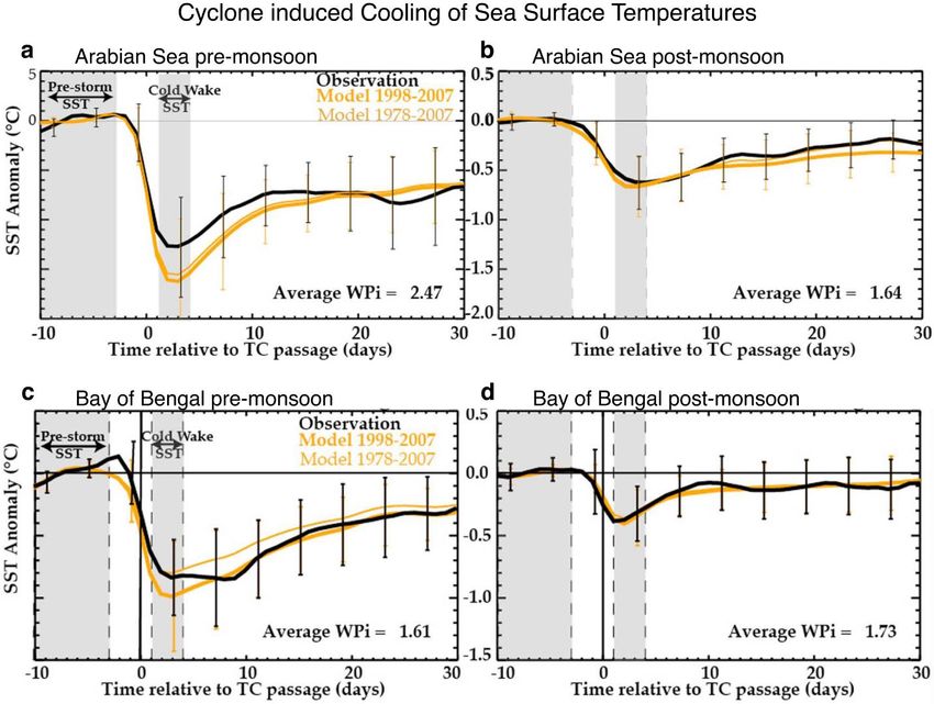
preprint https://arxiv.org/abs/2012.04384
pre-monsoon season (Rao 1987; Gopalkrishna et al. 1993; Sengupta et al. 2008) to 0.5ºC-1ºC in

the post-monsoon season (Subrahmanyam et al. 2005; Sengupta et al. 2008). For some cyclones

in the post-monsoon season, such as the Odisha super cyclone, cooling as large as 5ºC-6ºC and for

Cyclone Hudhud, cooling of 3ºC is observed (Sadhuram 2004; Rao 2007; Shengyan et al. 2019).

Similarly, in the pre-monsoon season, Cyclone Mala in 2006 induced a large SST cooling of 4°C-

5ºC (Badarinath et al. 2009; Vissa et al. 2012).

 The difference in the cyclone-induced SST cooling in the pre-monsoon and the post-

monsoon season is linked to the different characteristics of the north Indian Ocean in these two

seasons (Figure 1). During the post-monsoon season, the Bay of Bengal has a shallow mixed layer

and a thick barrier layer leading to strong stratification (Thadathil et al., 2007). However, in the

pre-monsoon season, the barrier layer is thin as compared to the post-monsoon season, leading to

a weaker stratification (Li 2017). During the cyclone, the presence of such a barrier layer in the

ocean inhibits the vertical mixing and suppresses the upwelling of cold subsurface waters to the

surface (Sprintall and Tomczak 1992; Wang et al. 2011; Vissa et al. 2013b). Maneesha et al. (2012)

show that a barrier layer formed due to the low saline water in the Bay of Bengal during Cyclone

Nargis in April 2008 played a major role in the intensification of the cyclone. Using a mixed layer

model, Vissa et al. (2013b) show that the presence of a thick barrier layer during Cyclone Sidr

resulted in reduced SST cooling. Using observation and high resolution coupled regional climate

model, Balaguru et al. (2012) show that strong salinity stratification is associated with weak

cyclone-induced SST cooling and strong latent and sensible heat fluxes from the ocean to the

atmosphere, which results in the increase in the intensity of the cyclones. They further suggest

that, the rate of intensification of cyclones over the barrier layer region in the north Indian Ocean

is 4.6 km h-1 in 36 hours (for the period 1998–2007) which is about 50% higher than the areas

 23
preprint https://arxiv.org/abs/2012.04384
where the barrier layer is absent (Balaguru et al. 2012). If we compare with other basins then it is

observed that the intensification rate of cyclone over the barrier layer was highest in the southwest

Pacific Ocean with an intensification rate of 9 km h-1 in 36 hours and lowest in the northwest

tropical Atlantic Ocean with an intensification rate of 3.5 km h-1 in 36 hours (Balaguru et al. 2012).

For the South Pacific Ocean, using model analysis, cyclone intensity is found to be increasing with

an increase in barrier layer thickness (at a rate of 5 hPa drop in cyclone central pressure for every

10 m increase of barrier layer thickness) (Jullien et al. 2014).

 Based on observational estimations for the period 1998–2004, it is found that due to the

absence of a thick barrier layer in the during the pre-monsoon season in the Bay of Bengal, the

cyclone induced cooling can reach up to 3ºC in the north Bay of Bengal (Sengupta et al. 2008).

On the other hand, in the post-monsoon season, due to the presence of a thick barrier layer, the

cyclone-induced cooling is only about 1ºC (Sengupta et al. 2008). A similar analysis by Neetu et

al. (2012) using an ocean general circulation model also shows that there is a significant difference

in the thermal stratification and upper ocean salinity of the Bay of Bengal in the post-monsoon and

pre-monsoon seasons. Due to these different ocean characteristics in the two seasons, the cyclone-

induced cooling is roughly three times more in the pre-monsoon season than the post-monsoon

season (Figure 6). There is a difference in the estimated cyclone-induced cooling between the

studies conducted by Sengupta et al. (2008) and Neetu et al. (2012). This difference is possibly

due to the difference in the area considered along the track of the cyclone to estimate the cyclone

induced cooling. On average, 60% of the reduction in the cyclone-induced cooling in the post-

monsoon season is contributed by thermal stratification and 40% by haline (salinity) stratification

(Neetu et al. 2012). There are regional variations on how these two factors lead to suppressed

cyclone induced cooling in the Bay of Bengal. In the north Bay of Bengal, it is generally the haline

 24
preprint https://arxiv.org/abs/2012.04384
stratification that controls the reduction in the cyclone induced cooling, particularly due to the

freshwater inflow and increased rainfall here. Whereas, in the southwest Bay of Bengal it is

generally the thermal stratification that governs the reduction in cyclone-induced cooling, as these

waters are characterized by the permanently warm SSTs above 28°C (Neetu et al. 2012; Roxy et

al. 2019). Due to the regional variation in the ocean subsurface characteristics (Figure 1), more

cyclone-induced cooling is generally observed in the south Bay of Bengal, and the magnitude of

SST cooling decreases as we head towards the north Bay of Bengal (Pothapakula et al. 2017). The

absence of haline stratification in the south Bay of Bengal results in more cyclone-induced cooling

in this region. A similar effect of haline stratification was observed in the Amazon-Orinoco river

region in the North Atlantic Ocean where strong fresh water discharge into the ocean results in

~50% reduction in the cyclone induced cold wake as compared to the open ocean (Reul et al. 2014;

Hernandez et al. 2016).

 Various case studies using BGC-Argo and moored buoy data during cyclones Gonu, Sidr,

Thane, Vardah show that the cyclone passage also affects the mixed layer of the ocean. It is found

that due to the vertical mixing induced by these cyclones, the mixed layer gets deepened by 15-30

m (Wang and Zhao 2008; Tummala et al. 2009; Chacko 2018a; Ye et al. 2018).

 Based on the cyclone data for 1998–2007, Lloyd and Vecchi (2011) show that the cooling

induced by the cyclones in the north Indian Ocean increases with an increase in the cyclone

intensity only up to category 2 (wind speed up to 95 knots). From a category 1 to category 2

cyclone, the SST cooling increases from 0.6°C to 1.1°C, with a difference of 0.5°C between the

categories (Figure 7). For cyclones of intensity greater than category 2, the cyclone-induced SST

cooling does not increase significantly with a further increase in the intensity of the cyclone. This

shows that the relationship between the SSTs and the cyclone intensity is not linear. On the

 25
preprint https://arxiv.org/abs/2012.04384
contrary, based on the wind power index (which is a proxy of the kinetic energy transferred by the

cyclone to the ocean) Neetu et al. (2012) show that the cyclone-induced cooling keeps on

increasing with the cyclone intensity. This contradiction can be due to the reason that the wind

power index incorporates both the intensity and the translation speed of the cyclone (Neetu et al.

2012; Vincent et al. 2012b). While numerous studies have explored cyclone-induced SST cooling,

only a limited have looked into the recovery process and time undergone by these SSTs to reach

the pre-cyclone level. It is observed that the recovery time of the SSTs to the pre-cyclone value is

not consistent and varies from six days to one month depending on the magnitude of the SST

cooling (Mandal et al. 2018).

 Similar to the Bay of Bengal, the cyclone-induced cooling in the Arabian Sea is more in

the pre-monsoon season than the post-monsoon season (Neetu et al. 2012). An average cooling of

1.2°C was observed in the pre-monsoon season and 0.6°C in the post-monsoon season, based on

observed data for the period 1998–2007 (Neetu et al. 2012) (Figure 6). Multiple case studies based

on observed data for cyclone 08A, Phyan, Phet and Ockhi show that cyclone induced cooling

varies from 2-6°C (Premkumar et al. 2000; Subrahmanyam et al. 2005; Naik et al. 2008; Byju and

Kumar 2011; Muni Krishna 2016; Singh et al. 2020). Using observations and modelling, Neetu et

al. (2012) show that the cyclone induced cooling is large in the pre-monsoon season due to large

cyclone wind power input. In comparison, cyclone induced cooling is weak in the post-monsoon

season due to the presence of thermal stratification (Subrahmanyam et al. 2005; Neetu et al. 2012).

Cyclone induced cooling is also found to vary with the intensity of the cyclone (Chowdhury et al.

2020b). Cyclone Chapala in the Arabian Sea post-monsoon season induced cooling of 0.5ºC in its

intensification phase, whereas a cooling of 1ºC was observed during its decay phase (Chowdhury

 26
preprint https://arxiv.org/abs/2012.04384
et al. 2020b). This varying response of SST is because of the different processes that are cooling

the SSTs during the life cycle of the cyclone.

 Cyclone rainfall also has a significant effect on the cyclone induced cooling (Jacob and

Koblinsky 2007; Jourdain et al. 2013). Jourdain et al. (2013) using data for the period 2002–2009,

show that the cyclone rainfall tends to reduce the cyclone induced cold wake due to the stabilizing

effect of rainfall that reduces the vertical mixing in the ocean induced by the cyclone. This

reduction in the cold wake due to cyclone rainfall is maximum in the Arabian Sea among all the

basins due to the strong thermal stratification which reduces the vertical mixing, leading to a

reduction of entrainment of cooler water from the subsurface to the surface (Jourdain et al. 2013).

The Bay of Bengal has a smaller effect in response to the cyclone rainfall on the reduction in the

cyclone induced cold wake because of the presence of a strong barrier layer, as discussed earlier.

 The cooling by the cyclone in the north Indian Ocean is mainly governed by the vertical

mixing induced by the cyclone winds (Murty et al. 1983; Girishkumar et al. 2014; Prakash and

Pant 2017; Kumar et al. 2019). This is in line with other basins as well, where also cyclone-induced

cooling is mainly governed by the vertical mixing and associated upwelling than the air-sea flux

exchange and advection (Price 1981; Jacob et al. 2000; Huang et al. 2009; Jullien et al. 2012).

Observations and coupled ocean-atmosphere model experiments show that during Cyclone Jal

(November 2010), that formed in the Bay of Bengal, the heat fluxes and horizontal advection

together contributed alone about 33% in the cyclone induced cooling. The remaining contribution

in the cooling was mainly from vertical mixing (Girishkumar et al. 2014). Similarly, Kumar et al.

(2019) using observations and model experiments show that during Cyclone Roanu, the cooling

due to air-sea fluxes contributed to only about 25% of the total cyclone-induced cooling,

highlighting that cyclone induced vertical mixing plays a dominant role in the cooling. This is

 27
preprint https://arxiv.org/abs/2012.04384
similar to the findings of Vincent et al. (2012a) in which they used model experiments for the

period 1978–2007 to show that for strong cyclones, vertical mixing and ocean mean state plays

dominant roles in cyclone-induced cooling. On the contrary, for Cyclone Sidr in the north Indian

Ocean,, Vissa et al. (2013b) using a mixed layer model show that when a barrier layer is present,

then the SST cooling is mainly driven by air-sea heat fluxes. On the other hand, in the absence of

the barrier layer, the SST cooling is mainly driven by the vertical mixing and entrainment flux.

Similarly for the period 1978–2007, using an ocean general circulation model, Neetu et al. (2012)

show that vertical mixing plays a major role in SST cooling in the pre-monsoon when the barrier

layer is absent. However, in the post-monsoon season, when the barrier layer is present, latent heat

fluxes play a major role in the cyclone induced SST cooling (Neetu et al. 2012). The factors

controlling the cyclone induced SST cooling also varies during the lifecycle of the cyclone. Based

on observational analysis for cyclone Chapala, Chowdhury et al. (2020b) show that during the

initial phase of the cyclone, the SST cooling is mainly due to the enhanced evaporation due to the

strong cyclone winds. However, in the decay phase, along with the evaporative cooling, the

vertical mixing and associated upward Ekman pumping also contributes to the enhanced cooling

after the passage of the cyclone (Chowdhury et al. 2020a).

 The cooling induced by the cyclone has a significant negative feedback on the cyclone

intensity (Bender and Ginis 2000; Zhu and Zhang 2006; Walker et al. 2014; Scoccimarro et al.

2017; Chen et al. 2018), mainly due to the reduction in the surface enthalpy fluxes (Bender et al.

1993; Schade and Emanuel 1999; Cione and Uhlhorn 2003). The negative feedback due to the

cyclone-induced is stronger in regions where the mixed layer is shallow or in the absence of barrier

layer (Jullien et al. 2014). In the north Indian Ocean, using an ocean-atmosphere coupled and de-

coupled experiment in regional model, Neetu et al. (2019) show that air‐sea coupling reduces the

 28
preprint https://arxiv.org/abs/2012.04384
pre-monsoon cyclone intensity. This is because intense cyclones induce large SST cooling in the

pre-monsoon season, which reduces the enthalpy fluxes from the ocean to the atmosphere.

However, this negative effect of air‐sea coupling on cyclone intensity is offset by the stronger

positive effect of seasonal changes in large‐scale environmental parameters such as wind shear,

and mid-level humidity. Further, they show that the effect of air-sea coupling on the contrast

between the intensity of the pre-monsoon and post-monsoon cyclones is smaller as compared to

the contrast in the environmental variables in these two seasons (Neetu et al. 2019). Similarly,

using a three-dimensional coupled model, Srinivas et al. (2016) show that, the coupling with the

ocean significantly reduces the cyclone intensity in the Bay of Bengal by reducing the enthalpy

fluxes up to 800 W m-2. Observations show a rapid weakening of Cyclone Ockhi immediately (1

day) after the cyclone induced cooling, resulting in a wind speed reduction from 85 knots to 30

knots in a span of 48 hrs (Singh et al. 2020).

 Interestingly, there are cyclone-ocean interactions in the north Indian Ocean that do not

cool the ocean surface. During post-monsoon season in the Bay of Bengal, Cyclone Thane (2011)

has increased the SSTs by 0.6ºC (Mathew et al. 2018). Using moored buoy observations, Chacko

(2018) shows that this warming after the passage of Cyclone occurred in the upper 40 m of the

ocean, whereas a cooling was observed in the depths of 40-80 m. This contrasting response of the

ocean is because of the presence of an inversion layer prior to the cyclone. As the cyclone moves

over the area of the inversion layer, warmer ocean subsurface water comes to the surface due to

cyclone-induced upwelling, leading to an increase in the SSTs after its passage.

4.2. Cyclone induced ocean heat transport

 29
preprint https://arxiv.org/abs/2012.04384
The average cyclone-induced ocean heat uptake is found to be 0.48 PW per year, based on SST

anomalies derived from the Tropical Rainfall Measuring Mission's (TRMM) Microwave Imager

(TMI) for the period 1998–2005 (Sriver et al. 2008). Emanuel (2001) suggest that cyclone-induced

mixing pumps ocean surface heat downward into the thermocline due to winds induced turbulent

mixing, and may be responsible for a significant amount of oceanic meridional heat transport.

However, not all of the heat pumped by the cyclone into the ocean is transported poleward, some

is lost into the atmosphere (Pasquero and Emanuel 2008). Also, the poleward transportation of

cyclone pumped heat may be significantly reduced due to the seasonal deepening of the mixed

layer depth (Jansen et al. 2010). Using observational analysis, it is estimated that about 15% of the

ocean heat transport from the tropics to the extratropics is associated with the cyclone induced

downward ocean heat pumping which is then transported poleward (Sriver and Huber 2007).

 Wang et al. (2012a), using a hybrid coordinate ocean model, show that two Bay of Bengal

cyclones (1999 post-monsoon season) significantly reduced the ocean heat content (maximum

reduction of 160 x 1018 J), due to a southward ocean heat transport out of the Bay of Bengal and

reduced downward net heat flux anomalies. The southward transport of the ocean heat out of the

Bay of Bengal is transported along the western boundary of the basin, and continues up to months

even after the dissipation of the cyclone (Wang et al. 2012a). This shows that cyclones in the north

Indian Ocean can significantly induce poleward heat transport out of the basin.

4.3. Effect of cyclone movement on the ocean-cyclone interaction

Cyclone induced cooling in the north Indian Ocean is also dependent on the translation speed of

the cyclone. The slow-moving cyclones (average speed of 9 km h-1, 25th percentile) cause relatively

 30
You can also read