2021-2022 ENGINEER'S WATER SUPPLY REPLENISHMENT ASSESSMENT REPORT
←
→
Page content transcription
If your browser does not render page correctly, please read the page content below
2021-2022
ENGINEER’S REPORT ON
WATER SUPPLY AND
REPLENISHMENT
ASSESSMENT

               Prepared for:

       Coachella Valley Water District

                Prepared by:

           West Yost Associates

              April 2021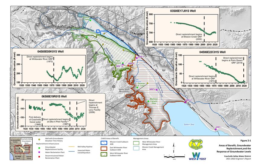
FINAL REPORT | APRIL 2021

               2021-2022 Engineer’s Report
Water Supply and Replenishment Assessment

                                      PREPARED FOR

                   Coachella Valley Water District

                                       PREPARED BY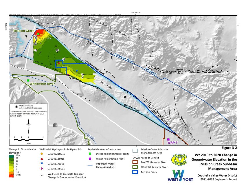
2021-2022 Engineer’s Report
Water Supply and Replenishment Assessment

                           Prepared for

     Coachella Valley Water District
                     Project No. 943-80-20-02

                                                       04-14-21
         Project Manager: Carolina Sanchez             Date

                                                       04-14-21
         QA/QC Review: Andy Malone                     Date

                                          FINAL REPORT | APRIL 2021
                                                    EARYEAR2020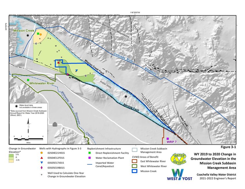
Table of Contents
Executive Summary............................................................................................................................ 1
      Mission Creek Subbasin Area of Benefit ................................................................................................ 1
      West Whitewater River Subbasin Area of Benefit ................................................................................. 2
      East Whitewater River Subbasin Area of Benefit ................................................................................... 2
1.0 Introduction ................................................................................................................................. 4
      1.1 Purpose of the Engineer’s Report .................................................................................................... 4
      1.2 Basin Description and Setting........................................................................................................... 4
      1.3 The Sustainable Groundwater Management Act ............................................................................. 7
      1.4 Organization of Report ..................................................................................................................... 8
2.0 Overview and history of Groundwater Replenishment and Assessment ......................................... 9
      2.1 Definition and General History of Overdraft Leading to the Groundwater Replenishment Program
      ................................................................................................................................................................ 9
            2.1.1 Definition of Overdraft............................................................................................................ 9
            2.1.2 General History of Overdraft in the Basin ............................................................................ 10
            2.1.3 History of Water Management by CVWD ............................................................................. 10
      2.2 Management Areas and Areas of Benefit ...................................................................................... 12
          2.2.1 Mission Creek Subbasin Management Area and Area of Benefit ......................................... 12
          2.2.2 West Whitewater River Subbasin Management Area and Area of Benefit.......................... 12
          2.2.3 East Whitewater River Subbasin Area of Benefit ................................................................. 13
      2.3 Replenishment Water Sources ....................................................................................................... 13
          2.3.1 Colorado River Water ........................................................................................................... 13
              2.3.1.1 Coachella Canal ........................................................................................................... 13
              2.3.1.2 Colorado River Water Allocations ............................................................................... 13
              2.3.1.3 QSA SWP Transfer ....................................................................................................... 14
              2.3.1.4 Drought Contingency Plan........................................................................................... 14
          2.3.2 State Water Project............................................................................................................... 15
              2.3.2.1 Table A Allocations ...................................................................................................... 15
              2.3.2.2 SWP Supplemental Water ........................................................................................... 16
              2.3.2.3 SWP Exchange to MWD............................................................................................... 16
              2.3.2.4 Advance Delivery Agreement ...................................................................................... 17
              2.3.2.5 Apportionment of State Water Project Exchange Water............................................ 17
              2.3.2.6 SWP Reliability ............................................................................................................. 17
              2.3.2.7 Delta Conveyance ........................................................................................................ 17
              2.3.2.8 Sites Reservoir Project ................................................................................................. 18
          2.3.3 Other Supplemental Water................................................................................................... 18
          2.3.4 Recycled Water ..................................................................................................................... 19
      2.4 Direct and In-Lieu Replenishment .................................................................................................. 19
          2.4.1 Mission Creek Subbasin Management Area and Area of Benefit ......................................... 19
          2.4.2 West Whitewater River Subbasin Management Area and Area of Benefit .......................... 20
          2.4.3 East Whitewater River Subbasin Area of Benefit ................................................................. 20

                                                                                   i                                              Coachella Valley Water District
                                                                                                                                                     April 2021
 n\c\943\80-20-02/wp/R
Table of Contents
      2.5 Groundwater Replenishment Program Assessment ...................................................................... 20
          2.5.1 Authority to Assess ............................................................................................................... 21
          2.5.2 Funding Mechanisms ............................................................................................................ 21
              2.5.2.1 Replenishment Assessment Charge ............................................................................ 21
              2.5.2.2 Coachella Valley Water District State Water Project Tax ............................................ 21
          2.5.3 Methods for Determining Groundwater Production ............................................................ 22
          2.5.4 Cost of Service Study............................................................................................................. 22
          2.5.5 Effects of Conservation ......................................................................................................... 23
3.0 Mission Creek Subbasin Area of Benefit ...................................................................................... 24
      3.1 Definition of Area of Benefit .......................................................................................................... 24
      3.2 Groundwater Conditions ................................................................................................................ 24
      3.3 Groundwater Production ............................................................................................................... 28
      3.4 Direct and In-Lieu Replenishment .................................................................................................. 28
          3.4.1 Replenishment Facilities ....................................................................................................... 28
          3.4.2 Direct Replenishment ........................................................................................................... 30
          3.4.3 In-Lieu Replenishment .......................................................................................................... 30
      3.5 Future Projects ............................................................................................................................... 31
      3.6 Need for Continued Replenishment ............................................................................................... 31
      3.7 Replenishment Assessment............................................................................................................ 31
          3.7.1 Groundwater Replenishment Program Costs ....................................................................... 31
          3.7.2 Methods for Determining Groundwater Production ............................................................ 31
          3.7.3 Income Statement ................................................................................................................ 32
          3.7.4 Recommended RAC for Fiscal Year 2021-2022..................................................................... 32
4.0 West Whitewater River Subbasin Area of Benefit ........................................................................ 33
      4.1 Definition of Area of Benefit .......................................................................................................... 33
      4.2 Groundwater Conditions ................................................................................................................ 33
      4.3 Groundwater Production ............................................................................................................... 35
      4.4 Direct and In-Lieu Replenishment .................................................................................................. 39
          4.4.1 Replenishment Facilities ....................................................................................................... 39
          4.4.2 Direct Replenishment ........................................................................................................... 39
          4.4.3 In-Lieu Replenishment .......................................................................................................... 39
      4.5 Future Projects ............................................................................................................................... 41
      4.6 Need for Continued Replenishment ............................................................................................... 41
      4.7 Replenishment Assessment............................................................................................................ 42
          4.7.1 Groundwater Replenishment Program Costs ....................................................................... 42
          4.7.2 Methods for Determining Groundwater Production ............................................................ 42
          4.7.3 Income Statement ................................................................................................................ 42
          4.7.4 Recommended RAC for Fiscal Year 2021-2022..................................................................... 42
5.0 East Whitewater River Subbasin Area of benefit.......................................................................... 44
                                                                             ii                                         Coachella Valley Water District
                                                                                                                                           April 2021
 n\c\943\80-20-02/wp/R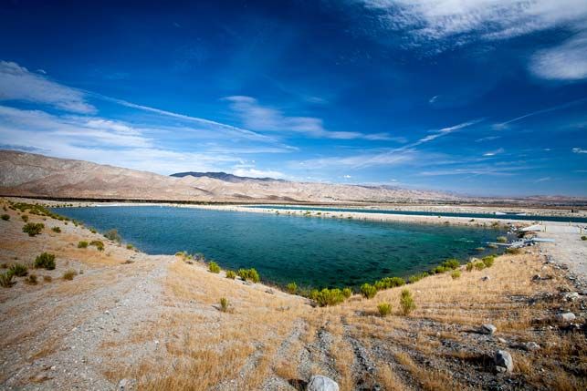
Table of Contents
      5.1 Definition of Area of Benefit .......................................................................................................... 44
      5.2 Groundwater Conditions ................................................................................................................ 44
      5.3 Groundwater Production ............................................................................................................... 46
      5.4 Direct and In-Lieu Replenishment .................................................................................................. 49
          5.4.1 Replenishment Facilities ....................................................................................................... 49
              5.4.1.1 Thomas E. Levy Groundwater Replenishment Facility ................................................ 49
              5.4.1.2 Martinez Canyon Groundwater Replenishment Facility Pilot Project ........................ 50
          5.4.2 Direct Replenishment ........................................................................................................... 50
          5.4.3 In-Lieu Replenishment .......................................................................................................... 50
      5.5 Future Projects ............................................................................................................................... 51
      5.6 Need for Continued Replenishment ............................................................................................... 52
      5.7 Replenishment Assessment............................................................................................................ 53
          5.7.1 Groundwater Replenishment Program Costs ....................................................................... 53
          5.7.2 Methods for Determining Groundwater Production ............................................................ 53
          5.7.3 Debt Consolidation ............................................................................................................... 53
          5.7.4 Income Statement ................................................................................................................ 53
          5.7.5 Recommended RAC for Fiscal Year 2021-2022..................................................................... 55
6.0 References ................................................................................................................................. 56

LIST OF TABLES

      Table 2-1. CVWD Colorado River Water Supply under the QSA in 2020.............................................. 14
      Table 2-2. State Water Project Exchange Delivery to Metropolitan Water District in 2020................ 16
      Table 3-1. Groundwater Production within the Mission Creek Subbasin Management Area ............. 29
      Table 3-2. Deliveries of SWP Water Exchanged for Colorado River Water for Direct Replenishment
                 at the Mission Creek Groundwater Replenishment Facility............................................... 30
      Table 3-3. Coachella Valley Water District Mission Creek Subbasin Area of Benefit Groundwater
                 Replenishment Program Income Statement ...................................................................... 32
      Table 4-1. Groundwater Production and Surface Water Diversions
                 within the West Whitewater River Subbasin Management Area ...................................... 38
      Table 4-2. Deliveries of Colorado River Water for Direct Replenishment at the West Whitewater
                 River Subbasin Management Area Replenishment Facilities ............................................. 40
      Table 4-3. Coachella Valley Water District West Whitewater River Subbasin Area of Benefit
                 Groundwater Replenishment Program Income Statement ............................................... 43
      Table 5-1. Groundwater Production within the East Whitewater River Subbasin Area of Benefit ..... 49
      Table 5-2. Deliveries of Colorado River Water for Direct Replenishment at the East Whitewater River
                 Subbasin AOB Replenishment Facilities ............................................................................. 51
      Table 5-3. Coachella Valley Water District East Whitewater River Subbasin Area of Benefit
                 Groundwater Replenishment Program Income Statement ............................................... 54
                                                                             iii                                        Coachella Valley Water District
                                                                                                                                           April 2021
 n\c\943\80-20-02/wp/R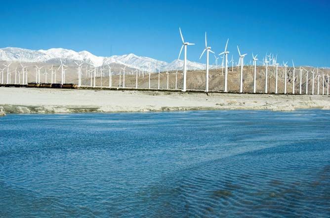
Table of Contents
LIST OF FIGURES
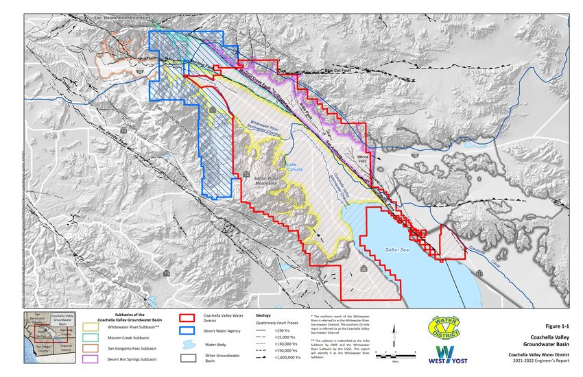
Figure 1-1. Coachella Valley Groundwater Basin ................................................................................... 5
Figure 2-1. Areas of Benefit, Groundwater Replenishment, and the Response of
Groundwater Levels ........................................................................................................... 11
Figure 3-1. WY 2019 to 2020 Change in Groundwater Elevation in the Mission Creek Subbasin
Management Area .............................................................................................................. 25
Figure 3-2. WY 2010 to 2020 Change in Groundwater Elevation in the Mission Creek Subbasin
Management Area .............................................................................................................. 26
Figure 3-3. Hydrographs and Direct Replenishment for the Mission Creek Subbasin
Management Area 2010 - 2020.......................................................................................... 27
Figure 4-1. WY 2019 to 2020 Change in Groundwater Elevation in the West Whitewater River
Management Area .............................................................................................................. 34
Figure 4-2. WY 2010 to 2020 Groundwater Elevation in the West Whitewater River
Management Area .............................................................................................................. 36
Figure 4-3. Hydrographs and Direct Replenishment for the West Whitewater River Subbasin
Management Area 2010-2020 ........................................................................................... 37
Figure 5-1. WY 2019 to 2020 Change in Groundwater Elevation in the East Whitewater River
Subbasin AOB ..................................................................................................................... 45
Figure 5-2. WY 2010 to 2020 Change in Groundwater Elevation in the East Whitewater River
Subbasin AOB ..................................................................................................................... 47
Figure 5-3. Hydrographs and Direct Replenishment for the West Whitewater River Subbasin
AOB 2010-2020................................................................................................................... 48
LIST OF ACRONYMS AND ABBREVIATIONS
af Acre-Feet
afy Acre-Feet Per Year
Annual Report SGMA Annual Report
AOB Area of Benefit
Basin Coachella Valley Groundwater Basin
CEQA California Environmental Quality Act
CVSC Coachella Valley Stormwater Channel
CVWD Coachella Valley Water District
CVWMP Coachella Valley Water Management Plan
CWA Coachella Water Authority
CY Calendar Year
DCP Drought Contingency Plan
DWA Desert Water Agency
DWR Department of Water Resources
EIR Environmental Impact Report
iv Coachella Valley Water District
April 2021
n\c\943\80-20-02/wp/RTable of Contents
ft Feet
FY Fiscal Year
GLC Glorious Lands Company
GRF Groundwater Replenishment Facility
GRP Groundwater Replenishment Program
GSP Groundwater Sustainability Plan
IWA Indio Water Authority
MSWD Mission Springs Water District
MVP Mid-Valley Pipeline
MWD Metropolitan Water District of Southern California
NPDES National Pollutant Discharge Elimination System
O&M Operations and Maintenance
PEIR Programmatic Environmental Impact Report
PPR Present Perfected Rights
QSA Quantification Settlement Agreement
RAC Replenishment Assessment Charge
Rosedale Rosedale Rio Bravo Water Storage District
SGMA Sustainable Groundwater Management Act
SWP State Water Project
TEL Thomas E. Levy
WRP Water Reclamation Plant
WRSC Whitewater River Stormwater Channel
WY Water Year
v Coachella Valley Water District
April 2021
n\c\943\80-20-02/wp/R2021 Engineer’s Report
Water Supply and Replenishment Assessment
EXECUTIVE SUMMARY
This 2021-2022 Engineer's Report on Water Supply and Replenishment Assessment (Engineer's Report)
was prepared for the Coachella Valley Water District (CVWD) to comply with State Water Code Sections
31630-31639 (Water Code). The Water Code allows CVWD to conduct groundwater replenishment
programs (GRPs) and levy and collect water replenishment assessments from non-exempt groundwater
producers that benefit from the GRPs. Groundwater pumpers that produce 25 acre-feet per year (afy) or
less are considered Minimal pumpers and are exempt from assessments.
Pursuant to the Water Code, the Engineer’s Report must provide a summary of the groundwater supply
conditions, the need for continued replenishment, a description of current GRPs, and recommendations
for Replenishment Assessment Charges (RAC) to be levied upon groundwater production from the three
defined areas that benefit from the GRP: the Mission Creek Subbasin Area of Benefit (AOB), the
West Whitewater River Subbasin AOB, and the East Whitewater River Subbasin AOB.
The GRPs are essential to the water management plans that were developed to prevent conditions of
overdraft and any associated undesirable results in all three AOBs. Groundwater replenishment is
accomplished through two mechanisms: direct replenishment, by which imported surface water is
percolated directly into the aquifer, and in-lieu replenishment, by which imported surface water or
recycled water is provided to groundwater pumpers for irrigation purposes, thus reducing or eliminating
their use of pumped groundwater.
Mission Creek Subbasin Area of Benefit
Historical declines in groundwater levels in the Mission Creek Subbasin led to a joint management
agreement between CVWD and Desert Water Agency (DWA) to cooperatively conduct the Mission Creek
Subbasin Management Area GRP in 2003.
In calendar year (CY) 2020, total assessable production in the management area was 14,244 acre-feet (af),
an increase of 9 percent from 2019. The assessable production in CVWD’s Mission Creek Subbasin AOB
was 4,655 af, which was approximately 33 percent of total production within the management area.
Replenishment of the Mission Creek Subbasin Management Area is currently accomplished via the
artificial recharge of State Water Project (SWP) water exchanged for Colorado River water at the Mission
Creek Groundwater Replenishment Facility (GRF). In CY 2020, a total of 1,768 af of Colorado River water
was delivered to the Mission Creek GRF for direct replenishment.
Since 2003, groundwater levels have risen and stabilized throughout the subbasin, which is evidence that
implementation of the GRP has effectively abated the overdraft that preceded it. Continued artificial
replenishment is necessary to maintain these positive trends and prevent a return to overdraft in the future.
To fund the costs associated with the GRP in the Mission Creek Subbasin AOB, CVWD staff recommend
no change to the $135.52/af RAC that became effective on July 1, 2017.
1 Coachella Valley Water District
March 2021
n\c\943\80-20-02/wp/R2021-2022 Engineer’s Report
Water Supply and Replenishment Assessment
West Whitewater River Subbasin Area of Benefit
Historical declines in groundwater levels in the western portion of the Whitewater River Subbasin led to
a joint management agreement between CVWD and DWA to cooperatively conduct the West Whitewater
River Subbasin Management Area GRP in 1976.
In CY 2020, total assessable production and surface water diversions in the management area totaled
153,979 af, which represents a 6 percent increase from CY 2019. Assessable production in CVWD’s
West Whitewater River Subbasin AOB was 117,770 af, which was approximately 76 percent of the total
assessable production and diversions within the management area.
Direct replenishment of the West Whitewater River Subbasin Management Area is currently accomplished
via artificial recharge of Colorado River water at the Whitewater River GRF and artificial recharge of
Colorado River water conveyed through the Mid-Valley Pipeline (MVP) to the Palm Desert GRF. In CY 2020,
a total of 126,487 af of SWP water exchanged for Colorado River water was delivered to the Whitewater
GRF, and a total of 9,700 af of Colorado River water was delivered to the Palm Desert GRF for direct
replenishment. CVWD also provides imported Colorado River water directly from the MVP or a blend of
Colorado River water and recycled water to 22 golf courses in the AOB to offset groundwater production
as a form of in-lieu replenishment.
Future planned replenishment projects include the completion of Phase II of the Palm Desert GRF and the
connection of approximately 23 additional golf courses to the non-potable water system between
2021 and 2031.
Since 1976, groundwater levels across most of the AOB have stabilized or are rising, which is evidence
that implementation of the GRP has effectively abated the overdraft that preceded it. Groundwater levels
have continued to gradually decline in a localized area of the northeastern portion of the AOB near Sun
City/Palm Desert and north of the Bermuda Dunes. Continued artificial replenishment is necessary to
maintain the increasing trends in groundwater levels, slow or reverse the declining trends in some areas,
and prevent conditions of overdraft in the future.
To fund the costs associated with the GRP in the West Whitewater River Subbasin AOB, CVWD staff
recommend that the $143.80/af RAC that became effective on July 1, 2017 be increased by $21.57/af, to
$165.37/af, effective July 1, 2021.
East Whitewater River Subbasin Area of Benefit
Historical declines in groundwater levels in the eastern portion of the Whitewater River Subbasin led to
CVWD's GRP for the East Whitewater River Subbasin AOB. Direct replenishment in the East Whitewater
River Subbasin AOB began in 1997, at the Dike 4 Pilot Facility, and the GRP became effective in 2005.
In CY 2020, assessable production in the AOB was 117,925 af, which represents less than a one percent
increase from 2019.
Direct replenishment of the AOB is currently accomplished via the artificial recharge of Colorado River
water at the Thomas E. Levy (TEL) GRF. In CY 2020, a total of 37,536 af of Colorado River water was
delivered for direct replenishment at the TEL GRF. CVWD delivers imported Colorado River water from
the Coachella Canal to meet the agricultural irrigation needs in the East Valley. CVWD also provides
imported Colorado River water to 32 golf courses in the AOB to offset groundwater production as a form
2 Coachella Valley Water District
April 2021
n\c\943\80-20-02/wp/R2021-2022 Engineer’s Report
Water Supply and Replenishment Assessment
of in-lieu replenishment. Nine holes of one golf course in the AOB receive a blend of recycled water and
Coachella Canal water from Wastewater Reclamation Plant (WRP) 7, and one golf course receives water
from the Coachella Canal via the MVP.
Future planned replenishment-related projects include: (i) Phase 2 of the Oasis Project,1 which is a
source-substitution project that involves the construction of a canal water distribution system in the Oasis
area to provide imported Colorado River water for agricultural irrigation on the Oasis slope; (ii) development
of a recycled water project at WRP 4 for additional source substitution; and (iii) the connection of three
additional golf courses to Coachella Canal water.
Since 2005, groundwater levels across most of the AOB have risen significantly, and historical artesian
conditions have returned to a wide area of the AOB, which is evidence that implementation of the GRP
has effectively abated the overdraft that preceded it. Continued artificial replenishment is necessary to
maintain these positive trends and prevent a return to overdraft in the future.
To fund the costs associated with the GRP in the East Whitewater River Subbasin AOB, CVWD staff
recommend that the $66.00/af RAC that became effective on July 1, 2016 be increased by $6.27/af, to
$72.27/af, effective July 1, 2021.
1
Phase 1 of the Oasis Project included two reservoirs to provide additional storage and operational
improvements/flexibility in the Oasis area. Construction on this phase of the project was completed in December 2020.
3 Coachella Valley Water District
April 2021
n\c\943\80-20-02/wp/R2021-2022 Engineer’s Report
Water Supply and Replenishment Assessment
1.0 INTRODUCTION
This report is the 2021-2022 Engineer’s Report on Water Supply and Replenishment Assessment
(Engineer’s Report) for the three Coachella Valley Water District (CVWD) Areas of Benefit (AOBs) within
the Coachella Valley Groundwater Basin (Basin): the Mission Creek Subbasin AOB, the West Whitewater
River Subbasin AOB, and the East Whitewater River Subbasin AOB.
This section describes the purpose of the Engineer’s Report, the Basin setting, the use of Sustainable
Groundwater Management Act (SGMA) Annual Reports for describing the conditions of groundwater
supplies, and the report’s organization.
1.1 Purpose of the Engineer’s Report
This report is prepared to comply with State Water Code Sections 31630-31639 (Water Code). The Water
Code provides CVWD with the authority to levy and collect water replenishment assessments within its
AOBs to implement groundwater replenishment programs (GRPs). Groundwater replenishment is
necessary to mitigate overdraft of the Basin and associated undesirable results. To levy and collect these
assessments, CVWD is required to prepare and present to its Board of Directors an annual Engineer’s
Report on the conditions of the groundwater supplies and recommended Replenishment Assessment
Charges (RACs) to be levied upon groundwater production within each AOB.
The Engineer’s Report must include the following information:
• A summary of the groundwater supply conditions.
• An assessment of the need for replenishment.
• A description of the replenishment programs, including the source and amount of
replenishment waters, the costs associated with the GRP, the areas directly and indirectly
benefited by the GRP, and the amount of groundwater produced in each area during the
prior year.
• A recommendation for the RAC to be levied on each AOB.
1.2 Basin Description and Setting
The Basin (Department of Water Resources [DWR] Groundwater Basin No. 7-021) resides in the
northwestern corner of a great structural depression called the Salton Trough, which extends from the
San Gorgonio Pass to the Gulf of California. The Basin is about 65 miles long on a northwest-southeast
orientation and covers approximately 440 square miles. Figure 1-1 shows the Basin bounded on the
southwest by the crystalline bedrock of the Peninsular Ranges (San Jacinto and Santa Rosa Mountains)
and on the northwest by the crystalline bedrock of the Transverse Ranges (San Bernardino and Little
San Bernardino Mountains). The Basin is located within the western portion of the Colorado Desert
Hydrologic Area.
4 Coachella Valley Water District
April 2021
n\c\943\80-20-02/wp/R2021-2022 Engineer’s Report
Water Supply and Replenishment Assessment
Precipitation on the Basin floor is typically less than five inches per year. Natural recharge to the Basin is
primarily from the recharge of mountain-front runoff. The Whitewater River is the major drainage course
in the Basin. Perennial flows exist in the portion of this drainage within the San Bernardino Mountains.
Along the valley floor, these perennial flows become ephemeral in the northern reach of the drainage,
referred to as the Whitewater River Stormwater Channel (WRSC). The constructed downstream extension
of the channel, known as the Coachella Valley Stormwater Channel (CVSC), conveys storm water,
groundwater entering subsurface drains, and discharge from National Pollutant Discharge Elimination
System (NPDES)-permitted wastewater facilities to the Salton Sea. Recharge to the Basin occurs in the
Whitewater River and other tributaries to the Basin, in the WRSC and CVSC, at constructed recharge
facilities, through percolation of irrigation return flows, and as subsurface inflow from the surrounding
mountains and groundwater basins.
The Basin is filled with up to 12,000 feet (ft) of sediments; the upper 2,000 ft constitute the aquifer system
that is the main source of groundwater supply in the region. The aquifer-system sediments were eroded
from the surrounding mountains and deposited in the Basin on alluvial fans, alluvial plains, and lacustrine
(lake) environments as interbedded, discontinuous layers of gravels, sands, silts, and clays. The sediments
tend to be finer-grained in the southeastern portions of the Basin due to the greater distance from the
mountainous source areas and the lower-energy depositional environments, such as historical Lake Cahuilla.
The Basin is cross-cut by several geologic faults, which have displaced sediments and created
low-permeability zones along the fault traces that act as barriers to groundwater flow. The DWR has
defined four subbasins within the Basin that are separated by geologic faults, bedrock constrictions, or
changes in formation permeability that limit and control the movement of groundwater: the Indio
Subbasin (DWR Subbasin 7-021.01),2 the Mission Creek Subbasin (7-021.02), the Desert Hot Springs
Subbasin (7-021.03), and the San Gorgonio Pass Subbasin (7-021.04) (DWR, 1964). Figure 1-1 shows the
locations of these subbasins.
While groundwater generally flows from northwest to southeast in the Basin, the structural features
present result in groundwater conditions that vary significantly between subbasins. In the San Gorgonio
Pass Subbasin, unconfined groundwater occurs throughout and flows generally west to east, where it
flows over a bedrock constriction and into the Whitewater River Subbasin.
In the Whitewater River Subbasin, groundwater typically flows from the forebay areas along the surrounding
mountain-fronts toward the valley floor and then southeast toward the distal portions of the Basin near the
Salton Sea. The aquifer system is unconfined in the forebay areas. In the southeast portion of the
Whitewater River Subbasin, the predominance of fine-grained sediments at depth has created three distinct
aquifer systems:
• A semi-perched aquifer up to 100 ft thick that is persistent across much of the area
southeast of the City of Indio. The fine-grain units that cause the perched conditions are
likely a barrier to deep percolation of surface water.
• An upper aquifer up to 300 ft thick that is present across most of the area. The upper aquifer is
unconfined except in the areas of the semi-perched aquifer where it is semi-confined.
2The subbasin is identified as the Indio Subbasin in DWR Bulletin 108 (1964) and Bulletin 118 (2003). However, the
subbasin is identified as the Whitewater River Subbasin by the USGS. This report identifies the subbasin as the
Whitewater River Subbasin for consistency with the naming of the East and West Whitewater River AOBs.
6 Coachella Valley Water District
April 2021
n\c\943\80-20-02/wp/R2021-2022 Engineer’s Report
Water Supply and Replenishment Assessment
• A lower aquifer that is 500-2,000 ft thick and is the most productive portion of the Basin. In
the southeast portion of the Basin, the lower aquifer is confined and is separated from the
upper aquifer by a fine-grained unit that is 100-200 ft thick.
In the Mission Creek Subbasin, groundwater typically flows from northwest to southeast. The aquifer
system is up to 2,000 ft thick and is predominantly unconfined. Portions of the aquifer along the Banning
Fault northwest of the Seven Palms Ridge area are semi-confined as evidenced by historically flowing
artesian wells in the area.
Overall, groundwater flow in the Desert Hot Springs Subbasin is to the southeast but is locally variable
due to faulting. The aquifer system is poorly understood due to relatively poor water quality, which has
limited the development of groundwater resources in the area. Faulting in the northern portion of the
subbasin has resulted in thermal mineral waters in the aquifer with temperatures up to 250 degrees
Fahrenheit. These thermal waters are used by several spas in the area.
1.3 The Sustainable Groundwater Management Act
California Senate Bills 1168 and 1319 and Assembly Bill 1739, signed by the Governor in September 2014,
amended the California Water Code to establish the SGMA. The SGMA requires the development of
groundwater sustainability plans (GSPs) for all basins designated medium- and high-priority by the DWR,
mandates the creation of local groundwater sustainability agencies (GSAs) to develop and implement the
plans, and outlines the guidelines and schedule for complying with the SGMA. The SGMA recognized the
efforts many agencies had made in developing and implementing groundwater management by allowing
existing groundwater management plans to be submitted as an alternative to preparing a GSP (Alternative
Plan). Under the SGMA, medium- and high-priority basins must achieve groundwater sustainability within
20 years of implementing their GSPs.
The DWR has designated the Whitewater River, Mission Creek, and San Gorgonio Pass Subbasins as
medium-priority subbasins not in critical overdraft. The Desert Hot Springs Subbasin was designated as a
very low-priority subbasin.
On November 6, 2015, CVWD submitted a “Notice of Election to Become a Groundwater Sustainability
Agency” to the DWR for the portions of the Whitewater River Subbasin and Mission Creek Subbasin that
are within CVWD's service areas. As an exclusive GSA over these areas, CVWD collaborated with Desert
Water Agency (DWA), Indio Water Authority (IWA), and Coachella Water Authority (CWA) as exclusive
GSAs to submit the 2010 Coachella Valley Water Management Plan (CVWMP) Update (CVWD, 2012) as
an Alternative Plan for the Whitewater River Subbasin. CVWD, DWA, and Mission Springs Water District
(MSWD) collaborated to submit the 2013 Mission Creek/Garnet Hill Subbasins Water Management Plan
(MC/GH Subbasins WMP) as an Alternative Plan for the Mission Creek Subbasin. Both Alternative Plans
were submitted to the DWR on December 29, 2016 and approved on July 17, 2019. The respective
agencies for each subbasin have since initiated the first five-year update mandated by DWR, due by
January 1, 2022.
The SGMA placed significant new requirements on GSAs to collect and report water management
information to the DWR to demonstrate sustainable groundwater management through implementation
of GSPs or Alternative Plans. On February 1, 2018, the DWR notified all GSAs who submitted Alternative
Plans that they would be required to submit annual reports pursuant to the SGMA by April 1, 2018 and every
year thereafter. The first SGMA Annual Reports (Annual Reports) for the Indio (referred to herein as the
Whitewater River) and Mission Creek Subbasins were submitted for Water Year (WY) 2016-2017 on
7 Coachella Valley Water District
April 2021
n\c\943\80-20-02/wp/R2021-2022 Engineer’s Report
Water Supply and Replenishment Assessment
March 31, 2018. The Annual Reports include information on groundwater elevations, groundwater
extractions, total water use, and change in groundwater storage. The most recent Annual Reports for WY
2019-2020 are utilized herein to describe groundwater supply conditions. Annual Reports are available
through CVWD’s SGMA webpage.3
1.4 Organization of Report
This Engineer’s Report is organized into six sections:
• Executive Summary describes the main conclusions of the Engineer’s Report
• Section 1 – Introduction describes the purpose of the Engineer’s Report, the Basin setting,
the use of the Annual Reports for describing the conditions of the groundwater supplies,
and the organization of the report
• Section 2 – Overview and History of Groundwater Replenishment and Assessment
summarizes the history and need for groundwater replenishment, the available sources of
water for replenishment, and the groundwater replenishment and assessment programs in
each of the AOBs
• Section 3 – Mission Creek Subbasin AOB describes the replenishment and pumping activities
for CY 2020, the condition of groundwater supplies, and a recommended RAC rate for the
Mission Creek Subbasin AOB
• Section 4 – West Whitewater River Subbasin AOB describes the replenishment and pumping
activities for CY 2020, the condition of groundwater supplies, and a recommended RAC rate
for the West Whitewater River Subbasin AOB
• Section 5 – East Whitewater River Subbasin AOB describes the replenishment and pumping
activities for CY 2020, the condition of groundwater supplies, and a recommended RAC rate
for the East Whitewater River Subbasin AOB
• Section 6 – References lists the publications referenced in this report
3
CVWD SGMA webpage
8 Coachella Valley Water District
April 2021
n\c\943\80-20-02/wp/R2021-2022 Engineer’s Report
Water Supply and Replenishment Assessment
2.0 OVERVIEW AND HISTORY OF GROUNDWATER REPLENISHMENT
AND ASSESSMENT
CVWD provides artificial replenishment of the Basin through its GRP. Groundwater replenishment is
accomplished through two mechanisms: direct replenishment, in which imported surface water is
percolated directly into the aquifer; and in-lieu replenishment, in which imported surface or recycled
water is provided to groundwater pumpers for irrigation purposes, thus reducing or eliminating their use
of pumped groundwater.
This section summarizes the history and need for groundwater replenishment, the available sources of
water for replenishment, and the groundwater replenishment and assessment programs.
2.1 Definition and General History of Overdraft Leading to the
Groundwater Replenishment Program
This section describes the definition and general history of overdraft leading to the GRP in the Basin.
2.1.1 Definition of Overdraft
The principal goal of the GRP is to arrest, reduce, and ultimately eliminate groundwater overdraft.
According to DWR Bulletin 118-80 (DWR, 1980):
“Overdraft is the condition of a groundwater basin in which the amount of water
withdrawn by pumping over the long-term exceeds the amount of water that recharges
the basin. Overdraft is characterized by groundwater levels that decline over a period of
years and never fully recover, even in wet years. Overdraft can lead to increased extraction
costs, land subsidence, water quality degradation, and environmental impacts.”
DWR Bulletin 118-80 states that overdraft conditions in a basin become "critical" when:
“[…] continuation of present water management practices would probably result in
significant adverse overdraft-related environmental, social, or economic impacts.”
DWR Bulletin 160-93 (DWR, 1994) expands on Bulletin 118-80's "period of years" as follows:
“Such a period of time must be long enough to produce a record that, when averaged,
approximates the long-term average hydrologic conditions for the basin.”
DWR Bulletin 160-09 (DWR, 2009) synthesizes the definitions provided in Bulletins 118-80 and 160-93
as follows:
“Overdraft is defined as the condition of a groundwater basin in which the amount of
water withdrawn by pumping exceeds the amount of water that recharges the basin
over a period of years, during which the water supply conditions approximate
average conditions.”
The above is the definition of overdraft used herein. As noted in Bulletin 118-80, however, groundwater
overdraft is characterized not only by a prolonged decline in quantities of groundwater in storage over
9 Coachella Valley Water District
April 2021
n\c\943\80-20-02/wp/R2021-2022 Engineer’s Report
Water Supply and Replenishment Assessment
long-term average hydrologic conditions but also by secondary adverse effects, including decreased well
yields, increased groundwater extraction costs, water quality degradation, sea-water intrusion, land
subsidence, and environmental impacts.
2.1.2 General History of Overdraft in the Basin
The historical occurrence of overdraft in the Basin was caused by the rapid development of agriculture in
the area during the early 1900s, followed by increasing urban and recreational development in the later
1900s. This growth led to increased water demands that were met by groundwater pumping, which
exceeded the natural recharge to the Basin and caused overdraft conditions.
Figure 2-1 is a map with time-history charts of measured water levels at key wells within the Basin. This
figure demonstrates the historical overdraft conditions characterized by the long-term declining trends in
groundwater levels across the Basin that necessitated the development of the GRP. The time-history
charts show the major milestones of the GRP. Note how groundwater levels stabilized or recovered after
the implementation of the GRP activities. As Figure 2-1 demonstrates, the GRP has been effective at
reducing or eliminating overdraft conditions in the Basin. Continuance of the GRP is necessary to combat
future overdraft conditions and meet the sustainability goals of SGMA.
2.1.3 History of Water Management by CVWD
The Coachella Valley County Water District, predecessor to CVWD, was formed in 1918 as an independent
special district with the primary responsibility of protecting local water resources. One of the first actions
taken by the district was to claim the rights to the Whitewater River to ensure that natural inflows of
water to the valley would stay in the valley and benefit the Basin.
Early settlers of the Coachella Valley also recognized that action was needed to address declining water
levels resulting from groundwater extraction. Their concern led CVWD to enter into an agreement with
the United States in 1934 for the construction of the Coachella Branch of the All-American Canal
(Coachella Canal) to bring Colorado River water to the Coachella Valley. Since 1949, the Coachella Canal
has been providing water for irrigation use in the eastern Coachella Valley as an alternate supply to
groundwater pumping.
In 1962 and 1963, respectively, DWA and CVWD entered into separate contracts with the State of
California to purchase water from the State Water Project (SWP). CVWD and DWA then entered into an
agreement with the Metropolitan Water District of Southern California (MWD) to exchange water from
MWD's Colorado River Aqueduct, which crosses the western portion of the Coachella Valley near
Whitewater, for CVWD and DWA allocations of SWP water.
In 1967, as agriculture and urban development continued in the Basin, further increasing water demands,
CVWD began a water reclamation program. The water reclamation program was created to provide a
reliable source of local non-potable water for irrigation and supplement the imported Colorado River
water brought into the East Valley via the Coachella Canal.
In 1973, artificial recharge of imported water from the Colorado River Aqueduct began at the Whitewater
River GRF in the western portion of the Whitewater River Subbasin. In fiscal years (FYs) 1978-1979 and
1980-1981, DWA and CVWD, respectively, began assessing non-exempt producers to cover the costs of
replenishment, thereby creating the GRP.
10 Coachella Valley Water District
April 2021
n\c\943\80-20-02/wp/R2021-2022 Engineer’s Report
Water Supply and Replenishment Assessment
The GRP has since been expanded to include: direct replenishment in the eastern portion of the Whitewater
River Subbasin, beginning in 1997; direct replenishment in the Mission Creek Subbasin, beginning in 2002;
and in-lieu replenishment, which is accomplished by providing supplemental waters to groundwater
pumpers for non-potable uses (e.g., irrigation) to reduce or eliminate groundwater pumping.
2.2 Management Areas and Areas of Benefit
Both CVWD and DWA are permitted by the Water Code to replenish the Basin and to levy and collect
groundwater replenishment assessments from any non-exempt groundwater producer or surface water
diverter within their jurisdictions who benefits from groundwater replenishment. The two agencies are
not required to implement assessment procedures jointly or identically.
The jurisdictional areas that benefit, either directly or indirectly, from the GRP and where CVWD or DWA
levy replenishment assessments are termed Areas of Benefit (AOBs). There are three AOBs within CVWD’s
boundary: the Mission Creek Subbasin AOB, the West Whitewater River Subbasin AOB, and the East
Whitewater River Subbasin AOB. CVWD and DWA have entered into water management agreements to
implement the GRP in areas of the Basin that include both of their respective jurisdictional boundaries.
Figure 2-1 shows the extent of CVWD’s AOBs and the two management areas cooperatively managed by
CVWD and DWA: the West Whitewater River Subbasin Management Area and the Mission Creek Subbasin
Management Area.
2.2.1 Mission Creek Subbasin Management Area and Area of Benefit
The Mission Creek Subbasin Management Area covers the entirety of the Mission Creek Subbasin. It was
initially formed on April 8, 2003 when CVWD and DWA entered into the Mission Creek Groundwater
Replenishment Agreement for the cooperative management of groundwater replenishment in the area
using SWP water exchanged for Colorado River water for direct replenishment. On December 7, 2004, the
agreement was amended by the Mission Creek Settlement Agreement to include the MSWD. On July 15,
2014, CVWD and DWA executed a new Mission Creek Groundwater Replenishment Agreement to update
and replace the 2003 agreement as amended.
Figure 2-1 shows CVWD’s Mission Creek Subbasin AOB, the portion of the Mission Creek Subbasin
Management Area residing within CVWD’s boundary.
2.2.2 West Whitewater River Subbasin Management Area and Area of Benefit
The West Whitewater River Subbasin Management Area is in the western portion of the Whitewater River
Subbasin. It was officially formed on July 1, 1976 when CVWD and DWA entered into an agreement to
cooperatively manage and cost-share in the GRP for this area by using SWP water exchanged for Colorado
River water for direct replenishment. The 1976 agreement was subsequently revised by the December 15,
1992 Water Management Agreement, which was later superseded by the July 15, 2014 Whitewater Water
Management Agreement.
Figure 2-1 shows CVWD’s West Whitewater River Subbasin AOB, the portion of the West Whitewater
River Subbasin Management Area within CVWD’s boundary.
12 Coachella Valley Water District
April 2021
n\c\943\80-20-02/wp/R2021-2022 Engineer’s Report
Water Supply and Replenishment Assessment
2.2.3 East Whitewater River Subbasin Area of Benefit
Figure 2-1 shows the CVWD East Whitewater River Subbasin AOB, which covers the eastern portion of the
Whitewater River Subbasin and extends from the eastern boundary of the West Whitewater River
Subbasin AOB to the shoreline of the Salton Sea. Since this area is entirely within CVWD’s service area, a
management agreement was not necessary. While in-lieu replenishment in this area began in 1949 with
the completion of the Coachella Canal and direct replenishment began in 1997 with the Dike 4 Pilot
Facility, CVWD did not designate it as an AOB until 2004.
2.3 Replenishment Water Sources
The supplemental water sources used for replenishment in the GRP include:
• Imported Colorado River water delivered via the Coachella Canal
• SWP water exchanged for Colorado River water with MWD
• Recycled water from CVWD water reclamation plants (WRPs)
• Other non-SWP supplemental water
These sources of replenishment water are described in more detail below.
2.3.1 Colorado River Water
2.3.1.1 Coachella Canal
The 122-mile long Coachella Canal was completed in 1948 and began operating in 1949. Water delivered
to the Coachella Valley via the Coachella Canal is diverted into the All-American Canal from the Imperial
Dam, located 18 miles upstream of Yuma, Arizona. It is then diverted into the Coachella Canal at “Drop 1”
of the All-American Canal, approximately 20 miles west of Yuma. The Coachella Canal conveys water
northward into the eastern Coachella Valley along the east bank of the Salton Sea, continuing northerly
past Mecca and Thermal to Indio, where it bends westerly, then continues southerly and southwesterly
to La Quinta, where it flows into Lake Cahuilla (constructed by CVWD in 1968 to provide operational
storage for Colorado River water). The Coachella Canal and Lake Cahuilla system distributes water for
irrigation to approximately 65,000 acres of agricultural land in the eastern Coachella Valley through nearly
500 miles of buried delivery laterals (CVRWMG, 2010). The capacity of the Coachella Canal is
approximately 1,500 cfs (CVWD, 2002a).
2.3.1.2 Colorado River Water Allocations
CVWD is part of the 1931 Seven Party Agreement that allocates California’s apportionment of Colorado
River water. CVWD was included in Priority 3(a) of the agreement in a group of California agricultural
agencies, collectively allocated 3.85 million acre-feet per year (afy). In 2003, the Quantification Settlement
Agreement (QSA) negotiated between CVWD, Imperial Irrigation District (IID), San Diego County Water
Authority (SDWCA) and MWD was signed, which supplemented the 1931 agreement. Under the QSA,
CVWD has a Colorado River water base allotment of 330,000 afy.4
4CVWD’s effective allotment is equal to the base allotment of 330,000 afy minus 29,000 afy in reductions, as
shown in Table 2-1.
13 Coachella Valley Water District
April 2021
n\c\943\80-20-02/wp/R2021-2022 Engineer’s Report
Water Supply and Replenishment Assessment
In addition, CVWD has executed transfer agreements for additional block amounts of Colorado River
water. The transfer agreements included the following:
• 1988 MWD/IID Approval Agreement for 20,000 afy
• IID to CVWD-First Transfer for 50,000 afy
• IID to CVWD-Second Transfer of 23,000 afy
Table 2-1 shows a breakdown of CVWD’s total allocation of 394,000 afy of Colorado River water in 2020.
The second transfer from the IID to CVWD will continue to increase from 23,000 afy in 2020 to 53,000 afy
in 2026, for a total allocation of 424,000 afy by 2026. In 2021, CVWD’s total allocation of Colorado River
water is 399,000 af.
Table 2-1. CVWD Colorado River Water Supply under the QSA in 2020
Description Total, af
Base Entitlement 330,000
(a)
Less Coachella Canal Lining (to SDCWA ) (26,000)
(b)
Less Miscellaneous/Indian PPRs (3,000)
(c)
1988 MWD/IID Approval Agreement 20,000
First IID/CVWD Transfer 50,000
Second IID/CVWD Transfer 23,000
Total 394,000
(a) San Diego County Water Authority.
(b) Indian Present Perfected Rights.
(c) The 2019 Second Amendment to the Delivery and Exchange Agreement allows CVWD to receive 15,000 AF of the 20,000 AF 1988
MWD/IID Approval Agreement at the Whitewater River GRF through 2026; MWD retains 5,000 AF. In CY 2020, CVWD received delivery
of 15,000 AF at the Whitewater River GRF.
2.3.1.3 QSA SWP Transfer
The QSA provides CVWD with a 35,000 afy transfer of SWP water from MWD. This SWP water is exchanged
for Colorado River water and can be delivered at Imperial Dam for delivery via the Coachella Canal to the
eastern portion of the Whitewater River Subbasin or can be delivered via the Colorado River Aqueduct for
delivery to the western portion of the Whitewater River Subbasin.
2.3.1.4 Drought Contingency Plan
Colorado River supplies face threats to reliability from the long-term drought and increasing variability in
snowpack, which have greatly reduced storage in the Colorado River system. On March 19, 2019, the
Governors’ representatives of the seven Colorado River Basin States and key water districts formally
submitted Drought Contingency Plans (DCPs) to Congress for immediate implementation. The DCPs are
intended to safeguard the reliability of Colorado River supplies and arrest declining water elevations at
both Lake Mead and Lake Powell. On April 8, 2019, the United States House and Senate both approved
the DCP, and on April 16, 2019 it was signed into law by the president. On May 20, 2019 the lower basin
14 Coachella Valley Water District
April 2021
n\c\943\80-20-02/wp/RYou can also read