ZARZAMORA CREEK GREENWAY TRAIL - San Antonio, Texas - San Antonio Report
←
→
Page content transcription
If your browser does not render page correctly, please read the page content below
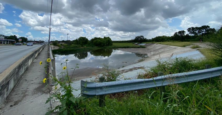
ZARZAMORA CREEK
                                    GREENWAY TRAIL
                                              San Antonio, Texas

DTOS59-21-RA-RAISE
FY 2021 National Infrastructure Investments
Department of Transportation
DOT OSDBU                                                July 2021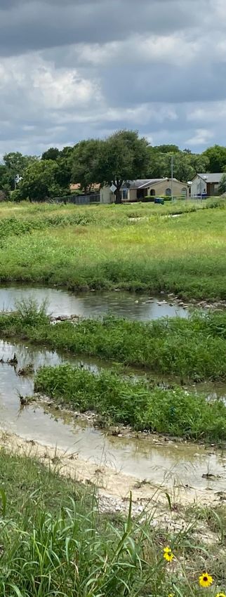
CONTENTS

                                    1     Project Description

                                    2     Project Location: A Tale of Two Cities

                                    8     Project Funding

                                    8     Merit Criteria

                                    16    Environmental Risk Review

                                    17    Benefit-Cost Analysis

                                    25    Project Readiness

                                    APPENDICES/ATTACHMENTS

                                            Bexar County Resolution: Rivers and Creeks
                                            Program
                                            City of San Antonio 2017 Ordinance-Bond
                                            Program
                                            Detailed Ingram Road Cost Estimate

                                            Environmental Memo
                                            Letters of Support

                                            Project Census Tract Evaluation
                                            Project Schedule
                                            VIA Ingram Transit Center Ridership Statistics

                                            2021 RAISE InfoForm
                                            BCA - Zarzamora Creek Greenway

ZARZAMORA CREEK GREENWAY TRAIL   San Antonio, Texas
PROJECT DESCRIPTION
                                         The City of San Antonio (City) is requesting $25 million for
                                         engineering, right-of-way and construction funds to
                                         complete the Zarzamora Creek Greenway Trail (ZCGT), a
                                         7.1-mile segment of the 82 mile Howard W. Peak
                                         Greenway Trails System which is an accessible, multi- use
                                         trail network adjacent to the VIA Metropolitan Transit
                                         Ingram Transit Center, City, Bexar County (County), and
                                         San Antonio River Authority (SARA) waterways, to
                                         improve: multi-modal access to employment centers;
                                         quality of life; safety; and health of several low-income
                                         communities of color. Completion of the Zarzamora
                                         Creek Greenway Trail will add connections to over 50
                                         trailheads, employment centers, cultural landmarks and
                                         recreational facilities throughout the City of San Antonio.

                                         Howard W. Peak Greenway Trails
                                         In the 1990’s, San Antonio Mayor Howard W. Peak, had an
                                         idea to build a ring of trails around the City along the
                                         Salado, Leon and Westside Creeks (Alazan, Apache,
                                         Martinez, San Pedro and Zarzamora) and Medina River.
                                         What began as a network of recreational trails in 2000 –
                                         upon completion – will be 130+ miles of multi-use trails
                                         accessible to San Antonio’s rich cultural history and iconic
                                         landmarks, interspersed between major, regional
                                         employment and educational centers including, but not
                                         limited to:
                                         • The Riverwalk
                                         • The Alamo
                                         • Fort Sam Houston/Lackland Air Force Base
                                         • San Antonio Missions National Park & Mission Reach
                                           Trail Segment
                                         • AT&T Center
                                         • The University of Texas at San Antonio
                                         • Historic West Side
                                         • Six Flags Fiesta Texas
                                         As of 2021, over 82 miles of trails have been completed;
                                         15 miles are under construction and another 17 miles
                                         are in some stage of planning or design across the City
                                         and County. Completion of this dynamic and diverse trail

ZARZAMORA CREEK GREENWAY TRAIL   San Antonio, Texas                                                     1
network will provide a vital connection to the City’s                              W. Peak Greenway Trails System to inform future
natural resources while providing mobility options                                 planning and development. Many of the survey’s
to San Antonio’s historically under-served Westside                                key findings highlight the desires of the 3,600+
communities. Since its inception, the Howard W.                                    respondents to close many of the trail gaps and
Peak Greenway Trail System has been funded                                         connect to more neighborhoods. Most telling from
through a voter-approved 1/8-cent Sales Tax Initiative                             the survey is the potential latent demand for use of
(Prop 2) which started in 2000 and has consistently                                the trail network during the weekday mornings and
been approved over three consecutive elections.1                                   low number of survey respondents from some of San
                                                                                   Antonio’s poorest communities.
Between November 2020 and January 2021, the
City of San Antonio Parks & Recreation Department
surveyed residents about their use of the Howard

                                      Figure 1. Zarzamora Creek Greenway Trail Project City & Country Context

                                                                                             Zarzamora Creek
                                                                                             Greenway Trail Project

                                      TEXAS

                    San Antonio

1   https://www.sanantonio.gov/ParksAndRec/News-Events/News-Press-Releases/
    Detail-Page/ArtMID/16253/ArticleID/16471/Parks-and-Recreation-Expands-
    Greenway-Trail-System-Encourages-San-Antonio-to-Get-Outside-and-Take-to-the-
    Trails?Park=&Facility=

ZARZAMORA CREEK GREENWAY TRAIL                                          San Antonio, Texas                                                2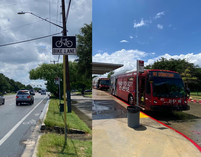
oad
R
zbach
ur
Figure 2. Project Area: Zarzamora Creek Greenway Trail
W
13 14 15 20
19
16
12
21 J
17
Ingram Road
11 18
Callaghan Road
22
Oak Hill Drive
10
W Broadview Drive
r
Hemphill Drive
23
9
8 24
7
6 r
W Commerce Street
4
5
PROPOSED ZARZAMORA GREENWAY BOND IMPROVEMENT PROGRAMS
Proposed Zarzamora Greenway Ingram Transit Center Trailhead Parks, Recreation and Open Spaces Streets, Bridges and Sidewalks
(Leon Creek Greenway to
4 Monterrey Park 8 Ingram Road
Tierra Del Sol Park) 4.7 miles Garza Park (Potranco Road to Dead End)
5 Tom Slick Creek Park
Ingram Road Multi-Use Trail 9 West Military Drive and
Tierra Del Sol Park
(Street connection) 1.8 miles Ingram Road Connectors
7 Sports Facilites near
Persistent Poverty Area Potranco Branch Library
R ainbow Ingram Road toLackland
Tierra Del Sol Park
Corridor
10 Ingram Road
dams (Creek path) 2.4 miles (Culebra Road to Mabe Road)
Park Land Camargo 11 Piper’s Meadow Park
Park
Hills Park Terrace Park Gateway Park
ill Park VIA Transit Center Connection 14 Heath Road/Grissom Road
(0.4 miles) Trails 12 Cathedral Park Intersection
Creek 13 Oscar Perez Park 19 Callaghan Road
(IH 410 to SP 421)
15 Jane Dubel Park
23 36th Street and Bangor Drive
16 Crystal Hills Park Intersection
17 Joan Price Park
Library and Cultural Facilities
20 Sunset Hills Park 6 District 6 New Library Site
21 Lee’s Creek Park 18 Forest Hills Branch Library
22 36th Street Park 24 Memorial Branch Library
Figure 3. Howard W. Peak Greenway Trails System Plan

                                                               The RIM
                                                              Trailhead                   1604
                                                                                        Trailhead

                                                                          Marquis
                                                                          Trailhead

                                                       Prue Road
                                                       Trailhead

                                                                                                                              Olmos Basin
                                                                                                                               Trailhead

                               Ingram Transit
                                   Center                                                           Texas Ave
                                                                                                                 Cincinnati Ave
                                                                                                    Trailhead
                                                                                                                    Trailhead

                                           Arvil Ave
                                           Trailhead

                                                                                                                Confluence
                                                                                                                   Park

                                                                                      WESTSIDE CREEKS &
                                                                                      SAN ANTONIO
                                                                                      RIVER WALK
                                                                                      TRAILS

                                                                                                                                            Stinson Airport
                                                                                                                                               Trailhead

P
    Major Trailhead Parking Areas
    (As of 2020)

    Universities

    Airports

    HWP Completed (Existing) Trails
    (As of 2020)

    San Antonio River Walk Trails
    Future Trails
    Waterways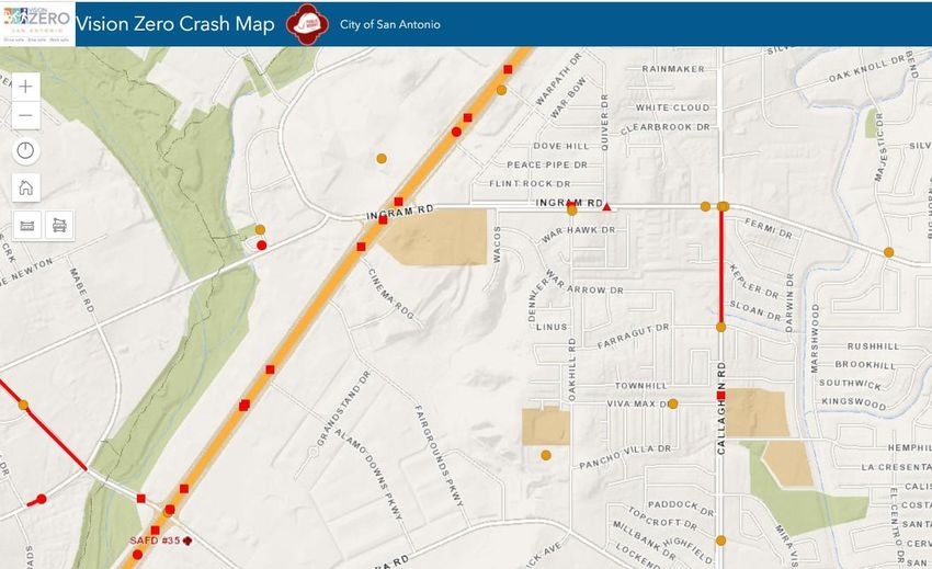
The trail connection between the VIA Ingram Transit
Center and Zarzamora Creek at Ingram Road will
connect three of the City’s poorest zip codes zip codes
(78238, 78228 and 78227) in the Project Area, which –
as seen from the top ten survey respondent zip codes
below – are not even listed. The VIA Ingram Transit
Center serves 10 routes including three of the top 20
highest ridership routes in the entire VIA system
(Routes 552, 534 and 82). Additional VIA ridership
statistics are provided as an Appendix.

                                                                              DEMOGRAPHICS
                                                                     Age Range                 Gender
                                                                     35-44 (25%)             Male (54%)
                                                                     45-54 (23%)             Female (44%)

ZARZAMORA CREEK GREENWAY TRAIL                  San Antonio, Texas                                          5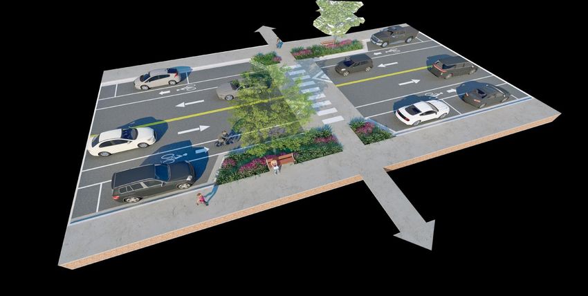
PROJECT LOCATION: A TALE OF TWO CITIES
The proposed Zarzamora Creek section of the Howard         a training facility for the nation’s most elite soldiers,
W. Peak Greenway Trails System to be completed with        who can often be found biking, walking and hiking the
RAISE funds is located in San Antonio, West of the         trails’ paved and off-road sections. Connecting our
historic Alamo and famous Riverwalk. The segment           nation’s military to free resources like the Greenway
extends north along the Zarzamora Creek from Tierra        Trails is but one of the reasons San Antonio has made
del Sol Park to Ingram Road, where it then extends         the list of the Country’s most affordable places to live
west to connect to the Leon Creek Greenway Trailhead       – and retire – according to USA Today – for our
at the VIA Metropolitan Transit Ingram Transit Center      military and anyone looking for a great quality of life.
– the second, most-used segment of the Howard W.
Peak Greenway Trails network – just behind the Salado
Creek segment, which is located northeast of
downtown San Antonio.

                                                           As one of the nation’s most important defense
                                                           installations, the 1956 National Interstate and
                                                           Defense Highways Act, better known as the
                                                           Eisenhower Federal Interstate System, was
                                                           instrumental to ensuring fast and efficient
                                                           deployment of the military during times of war. For
Military City USA                                          many years, San Antonio was just second to Los
As the 7th largest metropolitan city in the United         Angeles, California in the number of freeway miles.
States, with almost 1.6 million residents, San Antonio     According to data reported in 2017, Bexar County
has a storied history as the                               had one of the nation’s largest freeway systems with
“Home of the Alamo” and                                    1,004 centerline miles and 3,384 lane miles of state-
“Military City USA”, with                                  maintained roadways. At that time, the urbanized
over 300 years of continuous                               area of San Antonio had 258 centerline miles and
military presence. As a City                               1,435 lane miles of freeway, which carries over 50
that     has    the     largest                            percent of all local traffic in the San Antonio
concentration of military                                  metropolitan area.
bases in the Country,
graduating over 39,000 new                                 The number of freeways and military installations in
graduates annually from installations including the        San Antonio, although a source of great economic
Defense Department’s largest medical center at             access and opportunity, have come with a cost to
Fort Sam Houston, the Howard W. Peak Greenway              many communities. In the middle of the 20th
Trail – and the future connection to the Zarzamora         Century, construction of the Federal Interstate
Creek Greenway Trail segment – naturally serves as         System

ZARZAMORA CREEK GREENWAY TRAIL                  San Antonio, Texas                                                     6
displaced thousands of San Antonians. However, the          The Historic West Side has been challenged by
growth and development of Kelly Air Force Base and          myriad social, physical and economic shifts in
other military installations in San Antonio during the      infrastructure in San Antonio - once known as the
same period would provide decades of employment             “cultural capital” of Mexican American life in the
and educational opportunities to generations of San         United States. The presence of the military in San
Antonians, to support what would become one of the          Antonio had a profound effect on the economy of the
largest populations of middle class Mexican                 region and the Country. The impact of the military on
Americans. Sadly, with the Defense Department’s             the City was most evident in the lives of many
Base Realignment and Closure (BRAC), Kelly and              Mexican Americans who, according to research,
Brooks Air Force Bases would not fare well and were         comprised over 60 percent of the workforce on the
eventually closed in 2001 and 2011, respectively. The       Kelly Air Force Base at its height in the later part of
support of these and other military installations were      the 20th Century. The activation of the Kelly Air Field
centered around connectivity and access for vehicles;       – which would later become the Kelly Air Force Base –
not alternative modes of today.                             in December 1941 when the United States entered
                                                            World War II, created significant opportunities for
                                                            many San Antonians. Kelly Air Force Base would
                                                            become the largest employer on the West Side of San
                                                            Antonio, employing over 25,000 civilians – primarily
                                                            Mexican Americans.
                                                            The Historic West Side of San Antonio, like many
                                                            communities of color in the United States suffered
                                                            from years of disinvestment perpetuated from the
                                                            construction of the Eisenhower Federal Highway
                                                            System, which often led to the demolition of
                                                            significant community resources, but more
                                                            importantly, less access to opportunities as jobs left
                                                            the Central Business District (CBD) for suburban areas
                                                            of Bexar County for more affordable housing and
                                                            employment. As investments continued in the
                                                            suburbs, less infrastructure was supported in the
The Mexican “Mecca”                                         West Side, as shown in the City’s Equity Atlas, which
San Antonio’s military history often overshadows the        highlights the areas of persistent poverty, primarily
unique and rich history of San Antonio’s Historic West      populated by low-income, primarily Hispanic and
Side, where the Zarzamora Creek Greenway Trail              African-American Households.
Project connects to what was once home to one of
the largest populations of middle class, Mexican
Americans in the nation AND continues to be a
wellspring of cultural firsts for Latino Americans
since its heyday in the early to middle 20th Century.
Connecting the Zarzamora Creek Trail via Ingram
Road and the VIA Metropolitan Transit Ingram Transit
Center to the Leon Creek Greenway Trail will provide
a life-line to many residents on the West Side by
connecting them to the burgeoning technology jobs
accessible in the City by the transit and bicycling the
Howard W. Peak Trail network.

ZARZAMORA CREEK GREENWAY TRAIL                   San Antonio, Texas                                                   7
PROJECT FUNDING

Funding Sources                                                                          this funding is not directly realized on this project, it
The City of San Antonio will appropriate the funding                                     represents investment in the area and commitment
match from their 2022 Bond Program. Ordinance                                            to connecting the adjacent SARA waterways and
documents and Letters of Support from City and                                           trails.
County organizations are included as an Appendix.
                                                                                         Funding Uses
RAISE Funds               $25,000,000
City of San Antonio         $2,750,000
                                                                                         The RAISE award will support the City of San Antonio
Bexar County                $3,500,000
                                                                                         and its partners in constructing a 12-foot wide,
                                                                                         shared-use section of trail along the Zarzamora Creek
                                                                                         section of the Howard W. Peak Greenway Trails
                                                                                         System which connects to the San Antonio River
                                                                                         Authority’s Westside Creeks Restoration Project to
                                                         $31.25                          the south – which the Biden-Harris Administration
                                                         million                         recently allocated $2.34 million in its Fiscal Year 2022
                                                                                         budget, for design and engineering - and the VIA
                                                                                         Ingram Transit Center and Leon Creek Greenway Trail
                                                                                         on the north end. The City, County and SARA will
                                                                                         support the preliminary design and engineering for
                                                                                         the Zarzamora Creek Trail section with local funds
The San Antonio River Authority (SARA) has                                               and through the metropolitan planning process with
committed funding of $2.34M to adjacent trails. While                                    the Alamo Area Metropolitan Planning Organization
                                                                                         (AAMPO) and the Texas Department of
                                                                                         Transportation (TxDOT).

MERIT CRITERIA

Primary Criteria                                                                         much cheaper to build than a roadway on a per-mile
                                                                                         basis.3
Economic Competitiveness
                                                                                         Long-Term Job Creation
Long-Term Efficiency, Reliability, and Affordability                                     Based on a 2012 study that showed more jobs being
Completing the Zarzamora Creek Greenway Trail                                            created by greenways, sidewalks, and bicycle
will result in a return on investment related to                                         facilities than by any other transportation investment,
both transportation congestion and construction                                          completing this section of trail would create jobs for
cosst. Building more lanes of roadway only                                               this community of persistent poverty.4
encourages an ‘induced demand’ effect2, while
building more miles of trail encourages alternative
means of transportation, such as walking and
biking. Additionally, research shows that active
transportation infrastructure (like a multi-use trail) is
2   https://bikehouston.org/what-is-induced-demand/
3   https://www.railstotrails.org/resource-library/resources/active-transportation-
    transforms-america/
4   https://www.railstotrails.org/resource-library/resources/active-transportation-
    transforms-america/

ZARZAMORA CREEK GREENWAY TRAIL                                                San Antonio, Texas                                                     8
Environmental Sustainability developed sustainability goals, strategies, and metrics
of success that are being tracked and reported. To
Improves Energy Efficiency, Reduces Emissions, complement a bright future focused on innovation and
Avoid/Mitigates Environmental Impacts livability, the City of San Antonio is building on the SA
The proposed Zarzamora Creek Greemway Trail Tomorrow Sustainability Plan with SA Climate Ready, a
project would support the goals and objectives of strategic initiative that prepares us for the future as we
the City to improve energy efficiency and reduce focus on economic prosperity, environmental
transportation emissions by providing a regional regeneration and an equitable quality-of-life for all
trail for pedestrian and bicycle use, and also residents.6
connecting to mass transit to reduce the demand
for single-occupancy vehicles (SOV) use for many Climate Change
trips. The proposed Zarzamora Creek Trail would support the
proactive climate change goals and objectives of the
The City of San Antonio’s Office of Sustainability is City. On June 22, 2017, the City Council passed
working with partners to save water, improve air Resolution No. 2017-06-22-0031R in support of the
quality and reduce energy consumption within its Paris Climate Agreement; directing city staff to
municipal operations and community. San Antonio develop a plan to help San Antonio meet the
is a U.S. Pioneer of CitiesWithNature, a program objectives of this agreement. On October 17, 2019, the
of ICLEI, Local Governments for Sustainability. As City Council adopted the Climate Action & Adaptation
such, the City is committed to prioritizing nature- Plan (CAAP) by Ordinance 2019-10-17-0840.
based solutions to climate change, accounting for
ecosystem services and making sure residents in our
community have easy access to nature and the
outdoors.5
The SA Climate Ready CAAP requires the Office of
Sustainability to complete a Greenhouse Gas (GHG)
Inventory every two years. After passage of the plan in
late 2019, the opportunity arose to pursue data
collection for a 2019 inventory. This action allows for a
more up-to-date depiction of the impact of GHG’s inSan
In 2016, the City adopted the SA Tomorrow Antonio.
Sustainability Plan as a roadmap for enhancing our
community’s quality of life and overall resilience. The City of San Antonio is a National Association of City
It’s Transportation Officials (NACTO) partner and American
a plan to balance the impact of our expected Cities Climate Challenge designee and builds on our
growth to 2.6 million people by 2040 while history of leadership in sustainability and current
enhancing economic, environmental and social momentum promoting a resilient city.7
resources of the City. During the planning process
5 City of San Antonio, Conservation (sanantonio.gov)
the City engaged a broad range of thousands of
6 City of San Antonio Office of Sustainability, 2018 Progress Report
San Antonians to share their concerns and offer 7 City of San Antonio, American Cities Climate Challenge (sanantonio.gov)
ideas on how they want their city to look in the
near and distant future. The community then
ZARZAMORA CREEK GREENWAY TRAIL San Antonio, Texas 9The Climate Challenge will not only help San Antonio
reduce greenhouse gas emissions but will also
accelerate the City’s efforts to improve air quality,
expanding clean energy and transportation options,
and enhancing San Antonio’s competitive position in
the world marketplace.
The Climate Challenge provides the City with access to
the country’s leading technical assistance providers Of the nine Census Tracts located in the Zarzamora
around a variety of issues: Creek Greenway Trail impact area, four Census Tracts
are identified as Areas of Persistent Poverty:
• Reducing building energy use
• Expanding renewable energy • CT 1805.04
• Reducing vehicle miles traveled • CT 1805.1
• Advancing transportation electrification • CT 1816.02
• CT 1817.05
In partnership with NACTO, the City and VIA are
The red Census Tracts (1805.04 and 1805.04) represent
working cooperatively to identify ways to enhance
areas where over 97% “Speak English less than very
pedestrian, bike and scooter accommodations for the well.” And the combined income and race score are 9
disabled, and under-served populations. The out of 10. Further Census Tract and Equity data and
Zarzamora Creek Greenway Trail will support
maps are included in the Census Attachment.
multimodal connections to public transportation in
one of the City’s most impoverished communities. Incorporation of Electrification and Zero Emission
Vehicle Infrastructure
Environmental Justice
The proposed trail is designed for multimodal
The Zarzamora Creek Trail impact area includes nine
transportation (pedestrian and bicycles), while also
Census Tracts. According to the City of San Antonio
providing system linkages to public transportation. This
Equity Atlas, the combined score of race and income
proposed trail would encourage the use of zero
in the project area in the tracts immediately adjacent
emission transportation (bike/ped) to connect to VIA’s
to the project site - on a scale of 2 to 10, with 10 being
fleet comprised of a diverse mix of energy sources with
the highest- is 9, in Census Tracts 1805.04 and
a commitment to reducing emissions.
1816.02. These areas represent the highest
concentrations of low- income and people of color Building a modern EV charging system can increase
out of 4,704 and 5,924 households, respectively. consumer confidence in electric vehicles. The City of
San Antonio, working with CPS Energy, is analyzing
ZARZAMORA CREEK GREENWAY TRAIL San Antonio, Texas 10ways to enhance publicly accessible and private threatens the health of children, people who are
charging infrastructure. In addition, the EVSA active or work outdoors and those with respiratory
program unifies programs, policies, education and illnesses.9
infrastructure initiatives to make San Antonio a
more EV-friendly city. The Howard W. Peak Greenway Trails System is
located almost entirely within floodplains of the
waterways which they follow. To protect water
quality, mitigate the effects of flooding, and improve
ecosystem function, it is important to incorporate
“Green Infrastructure” elements in future trail design
and improvements. Low Impact Development (LID)
refers to landscape elements which use natural
systems for water infiltration, detention, and
retention to minimize negative impacts of
development near water bodies. These methods can
be adapted to a wide variety of contexts and
climates; however the central principles remain
consistent.10
The design of a sustainable trail that connects to
public transportation supports the goals and
objectives of the City to reduce air pollution. The LID
design of the proposed Zarzamora Creek Trail trail
would meet or exceed local, state, and Federal water
quality requirements and enhance and restore the
floodplain ecosystem.
In 2017, VIA began to replace the agency’s fleet of
clean-diesel-powered buses with vehicles that are Modal Shift to Reduce Emissions
fueled by Compressed Natural Gas (CNG). VIA has The proposed project supports the City’s goals and
diversified its fleet further by integrating new, objectives to incorporate multimodal transportation.
alternative power sources such as propane, The Howard W. Peak Greenway Trails is part of the
electricity, and hybrid technology. VIA continues to Multimodal Transportation Plan. San Antonio will
monitor fuel and propulsion technologies that help continue to experience significant population growth
improve air quality.8 over the next 25 years. SA Tomorrow is an
unprecedented, multi-faceted planning initiative to
accommodate this growth and has a comprehensive
land use plan, sustainability and multi-modal plan
elements. The planning effort will explore how to
preserve the San Antonio culture and increase
livability by ensuring connections between housing
and transportation choices as our City grows.11
The Multimodal Transportation Plan covers the entire
City of San Antonio and its extraterritorial jurisdiction.
8 VIA, About VIA-VIA Metropolitan Transit (viainfo.net)
Reduction of Air/Water Pollution 9 City of San Antonio, Sustainable Transportation Overview (sanantonio.gov)
10 City of San Antonio, Greenway Trails (sanantonio.gov)
In recent years, levels of air pollution in San 11 City of San Antonio, The Transportation Plan : San Antonio Multimodal
Antonio have been measured higher than Transportation Plan (satransportationplan.com)
allowed by federal clean air standards.
Prolonged exposure to polluted air particularly
ZARZAMORA CREEK GREENWAY TRAIL San Antonio, Texas 11It also takes into account al modes of transportation for input from the residents, business community,
including: auto, freight, rail, transit, biking, and and other stakeholders as to what a Resilient San
walking. The Multi-modal plan identifies: 1.) The Antonio means. This information will be used to
City’s transportation strategy for the future; 2.) evaluate possible strategies and policies to build our
Proposed improvements that address all modes; and community’s resilience and maintain “La Buena Vida”
3.) Method of prioritizing projects. as we live, work, and play in the Alamo City now and
in the future.12
The Multimodal Transportation Plan fulfills the
transportation component of the San Antonio Two key pillars of the plan include public health and
Comprehensive Plan, implements the goals of SA 2020; infrastructure. The proposed trail supports both of
complements the Alamo Area MPO’s Mobility 2040: these goals:
Metropolitan Transportation Plan; and VIA’s 2040 plan
to maximizeinfrastructure investments. 1. Public Health: As we experience a changing
climate, we will see increases in extreme heat-
related illnesses, deteriorated outdoor air quality,
increased flooding, increased vector-borne
diseases, and increased water and flood-related
infections. Many of these impacts will be borne
by our most vulnerable populations: children,
seniors, and our low-income residents.
2. Infrastructure: A damaged climate threatens the
well-being of San Antonio residents and the
essential infrastructure we depend on. Essential
infrastructure systems such as water, energy
supply, and transportation will increasingly be
compromised by interrelated climate change
impacts.
Support of the Renewable Energy Supply Chain
The City’s goal is to make San Antonio carbon
neutral by 2050—meaning that three decades from
now, the City will contribute no net carbon into
the atmosphere. Cultural resources studies will be
conducted in compliance with Section 106 of the
National Historic Preservation Act. In 2018, San
Antonio was recognized as the number seventh city
in the nation-and first in Texas- for locally installed
solar photovoltaic capacity. Throughout the design,
construction, and maintenance of the project, the The section of the proposed Zarzamora Creek Trail
City will look for ways to support the renewable along Ingram Road will incorporate Low-Impact
energy supply chain. Development (LID) practices like the vegetative
bump-outs shown in the graphic on page 13. As seen
Resiliency and Disaster Preparedness on the Ingram Road Typical Section on page 14, the
As part of the implementation of the SA LID design is seen in the grassy buffer between the
Tomorrow Plans, the City of San Antonio asked driving lane and shared-use path.
12 City of San Antonio, Resilient SA (sanantonio.gov)
ZARZAMORA CREEK GREENWAY TRAIL San Antonio, Texas 12Quality of Life Bexar County Bond Program section of trail,
expanding access for under-served
Increase of San Antonio is included in communities.
Transportation Choices
and Equity
the Urban Waters Federal
Improvement of Connectivity to Essential
The fastest growth Partnership Program helping Services
in bicycling is among urban and metropolitan The Zarzamora Creek Trail improves the
the Hispanic, African areas, particularly those connectivity from the neighborhoods of
American, and Asian that are under-served or Culebra Park, Thunderbird Hills, and Ingram
American population.13 Hills to many community resources. Such
Therefore, by constructing economically-distressed,
resources include public and private schools
the proposed Zarzamora connect with their waterways (ranging from elementary to high school),
Creek section of trail, and work to improve them. parks (Garza Park, Ingram Transit Center
not only would there be Trail, and Leon Creek Greenway), Forest Hills
an alternative means of Library, and Ingram Park Mall.
transportation, there
would be an alternative means of transportation Proactive Address of Racial Equity and
for an under-served and diverse community that is Barriers to Opportunity: Multimodal
populated by the specific groups experiencing the Mobility Investments
fastest growth in bicycling. Completion of a trail segment that connectsto
other trail segments will provide a safe place
Expanding Access for Under-served Communities for, and promote, physical activity for
The proposed Zarzamora Creek section of trailis a everyone. Walking/biking along a trail is a
crucial piece of the Howard W. Peak Greenway free activity, making a trail system an ideal
Trails System because it will connect to a means of transportation for low-income
completed section of trail, communities.14 This section of trail is
and a proposed Bexar County Bond Program especially instrumental in connecting the
section of trail, expanding access for under- Zarzamora Creek area to the VIA Ingram
served communities. Transit Center.
13 The New Majority: Pleading Towards Equity, page 3
14 https://keepsamoving.com/wp-content/uploads/2020/09/KSAM_plan_summary.pdf
The section of the proposed
Zarzamora Creek Trail along
Ingram Road will incorporate
Low-Impact Development (LID)
practices like the vegetative
bump-outs shown; Less invasive
infrastructure supports the two
key pillars of the SA Tomorrow
Plan by protecting water
quality and designing green
infrastructure.
ZARZAMORA CREEK GREENWAY TRAIL San Antonio, Texas 12Occurrence of Crashes, Injuries, and Fatalities
THE The section of the Zarzamora Creek Greenway Trail
AVERAGE along Ingram Road will create a dedicated bike/ped
VIA RIDER trail. This type of infrastructure allows for a more
comfortable and safer experience for pedestrians and
• Is employed full-time cyclists of all ages. From 2018 through April of 2021
there were 15 pedestrian crashes on Ingram Road.
• Uses VIA 5-7 days a week
Three of these crashes resulted in a serious injury.
• Works at least one weekend day The 1.8–mile section along Ingram Road will allow
• Doesn’t have a vehiclee in the more direct access to multimodal options at the VIA
household Ingram Transit Center and greater connectivity to
• Lives below the federal poverty other educational and recreational facilities in the
line (a household income under area.
$25,000 annually)
With our 21st-Century push to utilize alternative
Source: “Who is the Rider” 2019 Survey means of transportation, improving pedestrian
infrastructure is paramount. According to a July 2020
The vital connections of the Zarzamora Creek serve Vision Zero San Antonio report, between 2014 and
the most impoverished portions of the City. Of 10 2018, 121 severe bicyclist injury crashes16 and 847
routes served by the VIA Ingram Transit Center, three severe pedestrian injury crashes17 occurred on San
routes are in the Top 20 Highest Ridership Routes in Antonio roadways. Callaghan Road from Ingram Road
the VIA system (90 routes total) making the Ingram to Farrgut Drive, and Culebra Road from Laven Drive
Transit Center a vital transfer point. More information to Vanley Drive were even identified as Severe
regarding VIA Ingram Transit ridership statistics can be Pedestrian Injury Areas in 2020.18
found as an Appendix.
These worrisome statistics are not unique to San
Safety Antonio. In Texas, pedestrian fatalities totaled 717
(8.47 percent increase from 2019), and pedal/cyclist
Safe Movement of Goods and People fatalities totaled 79 in 2020 (16.18 percent increase
A survey for already-completed sections of the from 2019). Furthermore, total pedestrian and
Howard W. Peak Greenway Trails System showed that pedal/cyclist crashes in Texas were 4,844 and 2,170,
the Top 5 Reasons for trail use included pedestrian respectively.19 Additionally, Texas was part of the Top
safety.15 20 Most Dangerous Statesfor Pedestrians (2010-2019)
list20 (See map on Page 15).
San Antonio has the opportunity to be a leader and
example for the rest of Texas and the United States, in
the movement for more protected pedestrian
infrastructure through completion of the Howard W.
Peak Greenway Trail network in San Antonio.
15 https://www.sanantonio.gov/Portals/0/Files/Parks/Linear%20Creekways/Survey%20Report.pdf?ver=2021-05-24-182432-293
16 https://www.visionzerosa.com/Portals/38/Files/2020%20Vision%20Zero%20SBIA%20FINAL%20In%20Pages%20CORRECTION%20Reduced.pdf?ver=2020-09-22-095138-670
17 https://www.visionzerosa.com/Portals/38/Files/2020%20Vision%20Zero%20SPIA%20FINAL%20In%20Pages_Reduced.pdf?ver=2020-09-09-115349-287
18 https://gis.sanantonio.gov/PW/VisionZero/index.html
19 https://ftp.txdot.gov/pub/txdot-info/trf/crash_statistics/2020/07.pdf
20 https://smartgrowthamerica.org/dangerous-by-design/
ZARZAMORA CREEK GREENWAY TRAIL San Antonio, Texas 13State of Good Repair conditions occurs regularly using equipment outfitted
with information-gathering tools to generate information
Plans for Maintenance of System
for Parks’ Maintenance staff concerning obstacles in the
In 2012, San Antonio voters approved a bond to
clear zone, deteriorating pavement conditions, fallen
fund parks, recreation and open space which
trees, boulders or encroachments in the trail right-of-way
generates revenue for operations, maintenance,
that would hinder the regular use of the transportation
and capital project improvements on trails, parks
corridor.
and open space in the City.
The Zarzamora Creek Greenway Trail will be designed
Based on past budgets, annual trail maintenance
and constructed to City of San Antonio Design
is estimated at $95,000/mile. Trail maintenance
Guidance Manual, NACTO – Urban Bikeway Design
activities are tracked based on visual inspection
Guide (2012); AASHTO – Guide for the Development of
during weekly maintenance activities, citizen action
Bicycle Facilities (2012); ADA Accessibility Guidelines
requests and use of ratings in a pavement
(ADAAG)’ and Public Right-of-Way Accessibility
management system. Trail surfaces are replaced
Guidelines (PROWAG).
according to industry-standard maintenance
schedules. Inspection of trail surfaces and
Ingram Road Proposed Typical Section
5′ 11′ 11′ 11′ 11′ 11′ 4′ 12′
Sidewalk Drive Lane Drive Lane Two-Way Left Drive Lane Drive Lane Buffer Shared Use Path
Turn Lane
Zarzamora Creek Proposed Typical Section
ZARZAMORA CREEK GREENWAY TRAIL San Antonio, Texas 14TOP 20
Most dangerous states for pedestrians (2010-2019)
19
Michigan
11
Nevada 5 Delaware
17
20
Missouri 18 Maryland
Kentucky
16
Tennessee
California
14 12 13 North
15 Carolina
7 3 Oklahoma
Arkansas 8
Arizona New Mexico 9 South
2
Carolina
4 Georgia
Mississippi
6
10 Alabama
Texas Louisiana
1
Florida
201 175
150 143 140 133
128 128 127 125 122 115
102 99 93 77 74 72 67 66
FL AL NM MS DE LA AZ SC GA TX NV TN NC OK AR CA MO MD MI MI
2010-2019 Pedestrian Danger Index
Sustainable Revenue for Life-Cycle Costs this project will be carried-out by TxDOT pursuant to 23
Upon completion, the Zarzamora Creek Greenway Trail U.S.C. 327 and a Memorandum of Understanding dated
section will be incorporated in the Howard W. Peak December 9, 2019, and executed by FHWA and TxDOT.
Trails System Plan for regular and preventative The City will serve as the project sponsor and coordinate
maintenance to enable use of this transportation asset with TxDOT for NEPA and other applicable Federal
for the duration of its engineered life cycle and safe environmental laws and requirements.
conditions for the public.
Partnership
Secondary Criteria
Community Outreach and Public Engagement
The City of San Antonio has been reporting regularly on
Innovation
the Zarzamora Creek Trail project to the Linear Creekway
Environmental Permitting Parks Advisory Board (LCPAB) and taking their input
Due to federal transportation funding through the (verbally) on scopes of work and design. LCPAB members
RAISE Grant, this project will be subject to the are citizens from each council district, appointed by the
National Environmental Policy Act (NEPA). In Texas, City’s 10 Council members. Public meetings in compliance
FHWA has delegated NEPA to the Texas Department with the AAMPO/TxDOT public engagement guidelines are
of Transportation (TxDOT). Therefore, the anticipated for this project as part of the development
environmental review, consultation, and other actions process.
required by applicable Federal environmental laws for
ZARZAMORA CREEK GREENWAY TRAIL San Antonio, Texas 15The Howard W. Peak Trail projects were approved industry. With support and engagement with the
by San Antonio voters in and the project lists are Hispanic Chamber of Commerce, the City will promote
regularly reviewed/approved by the LCPAB during this new trail segment and its connections to hospitality,
their open meetings. technology, education and other job opportunities
throughout the City. Additionally, as part of the AAMPO
Coordination with Economic Alamo Commutes program, the City and the
Development Transportation Department will survey and identify
latent demand for transportation alternatives/education
The San Antonio River Authority (SARA) will be to inform business owners of the myriad alternative
making the Westside Creeks Restoration transit and bike opportunities their employees can use
improvements to an area that the proposed trail for their commute.
will be connecting to on the southern end. A key
element of the coordination with SARA is Sharing the economic benefit of alternative
connecting the Mission Reach/Riverwalk trails to transportation options and savings they can potentially
the Zarzamora Creek Trail segment to advance experience will help create enhanced partnerships with
connections to the tourism economy of San VIA, the City and the Chamber of Commerce member
Antonio. The City’s myriad Chambers of organizations. Education about trails is a major obstacle
Commerce and SARA work cooperatively to to increasing the use of multi-use trails for work
educate and promote the vital water resources in commutes. These alternative modes can also defray
the City and County through the tourism industry, costs associated with building and constructing more
where the City lost almost $475 million in revenue parking structures, which are a significant cost to
during the COVID-19 pandemic. businesses. Walking or bicycling to a transit center is
more convenient than parking at transit centers.21
The Zarzamora Creek Trail segment will connect
the most vulnerable San Antonians on the Historic
West Side with job opportunities in the hospitality
ENVIRONMENTAL RISK REVIEW
Environmental risk for the Zarzamora Creek section outside the range of Federally-listed threatened,
of the regional trail is low. The schedule to obtain endangered, or candidate species. No coordination or
environmental clearance (a Categorical Exclusion permitting would be required with the U.S. Fish and
(CE) determination) from TxDOT is anticipated to be Wildlife Service (USFWS) under the Endangered Species
approximately five months. The National Act (ESA).
Environmental Policy Act (NEPA) process will begin The project may require review and approval by the
when the Advanced Funding Agreement (AFA) has U.S. Army Corps of Engineers (USACE) under Section 404
been signed by the City and TxDOT and will be of the Clean Water Act. However, avoidance and
handled concurrently with the design. minimization measures will be incorporated into the
An environmental desktop survey has been design so that the project would qualify for a non-
conducted for this project to evaluate the reporting Nationwide Permit 14 for transportation
environmental risk and NEPA requirements. For projects. No environmental mitigation is anticipated to
more details review the attached Environmental be required for crossing waters of the U.S. An
Document in the application. Based on the environmental desktop survey has been conducted for
environmental review for this project, it is this project to evaluate the environmental risk and NEPA
anticipated that this project would be classified as requirements and can be found in full in the
a CE, specifically a c(3) CE. No Environmental Environmental Documentation attachment.
Assessment (EA) or Environmental Impact
21 Active Transportation Doc, pg 31
Statement (EIS) would be required. This project is
ZARZAMORA CREEK GREENWAY TRAIL San Antonio, Texas 16BENEFIT-COST ANALYSIS No-Build Scenario
Under the no-build scenario, the trail does not exist,
and thus would lack all recreational benefits. The
Introduction potential health benefits and safe mobility options for
This BCA report provides the technical background bike and pedestrian commuters would not exist. This
for the analyses conducted in support of the RAISE could result in higher incidences of obesity and other
grant application for the Zarzamora Creek illnesses linked to physical inactivity or lack of access
Greenway Trail Project (ZCGT). Included are the to affordable recreational facilities. There is also
approach and methodology for comparing the no- the potential for an increase in vehicular accidents
build and build scenarios. and emissions as the population growth would only
be sustained by the existing roadway network with
The BCA spreadsheet in the Appendix that limited active transportation choices. Additionally,
accompanies this report is broken into several tabs property value would potentially see limited increases
which present the methodologies, inputs, and data in value due to lack of investment in the area.
sources used to calculate the costs and benefits
presented here. Analysis Period
Based on USDOT’s guidelines, this analysis covers the
Benefit Cost Analysis Spreadsheet
period from which the ZCGT project was proposed
Approach through construction and the subsequent 30 years of
The BCA spreadsheet that accompanies this report is operation. The 30-year analysis period was chosen to
broken into several subject areas which present the reflect the intended long-lasting duration of the
methodologies, inputs, and data sources used to project within the City of San Antonio. It is anticipated
calculate the costs and benefits presented here. that the benefits which accrue from the project will be
seen long after the initial 30-year analysis period as
Approach and Methodology the Howard W. Peak Greenway Trails System
continues to expand into its envisioned footprint.
In accordance with USDOT BCA guidelines, the BCA
analyzes the effects of implementing the proposed
project against the no-build scenario. The net Inflation and Discounting Adjustments
benefits from both scenarios are compared to The BCA analysis incorporates the USDOT’s guidelines
understand the project’s expected impact. for inflation adjustments in the calculations of
the benefits and costs. All benefits and costs are
Build Scenario estimated in 2022 dollars with future dollars
discounted in compliance with RAISE, using a
The build scenario assumes the construction of the 7 percent real rate. Below are the assumptions that
ZCGT. The proposed project will improve health were applied in the BCA model to ensure costs and
benefits by providing recreational facilities and benefits were accurately reflected:
increasing physical activity, while also providing a safe
mobility option for commuters who walk or bike to • The costs and benefits in this BCA analysis
work, school, etc. At the same time, the project will correspond to the effects of the full build-out of the
enhance vehicular safety at surrounding intersections ZCGT.
and eliminate pollution emissions by inducing users to • Input prices are in 2022 dollars.
walk or bike instead of drive to their destinations.
Lastly, the project is expected to enhance surrounding
property values by facilitating increased development.
ZARZAMORA CREEK GREENWAY TRAIL San Antonio, Texas 17• Analysis begins in 2022 (Scoping) and ends in 2054. Forecasting Future Demand
Project development and construction are assumed Using the existing demand as a foundation, future
in 2022–2023, with O&M covering the entire 30- demand for cyclists and pedestrians along the project is
year period from 2024 – 2054. calculated using methodology from the NCHRP Report
• The first year of benefits is 2025 and no ramp-up 552: Guidelines for Analysis of Investments in Bicycling
benefits are assumed for 2024. Facilities. There are three parameters used to provide
• A 7 percent real discount rate is assumed assumptions for statistics involving commuter and
throughout the period of analysis. recreational demand for the new trail. The first focuses
on the population within 0.5 miles of the ZCGT project
to remain consistent with the NCHRP report. The
Demand Estimation NCHRP also provides assumptions for calculating the
Demand estimation is based on the NCHRP 552 commuter statistics for pedestrians and cyclists. The
Report recommended approach: report assumes that 80 percent of residents are
adults, and based on national averages, 50 percent of
Number of Adult Commuters = R * 0.4 adults commute resulting in an estimate of 40 percent
Daily Existing Commuters = R * C * 0.4 of the population commuting to determine the bicycle
and pedestrian commuters along the trail. The bike
T(moderate) = 0.4 +1.2C commuter share is estimated to be 1.99 percent of the
population. The pedestrian commuter share is
Existing Users = R * T * C estimated to be 6.1 percent of the population.
Ld = Distance from Project (L(400m) = 2.93, L(800m)
= 2.11, L(1600m) = 1.39)
New Adult Users = ∑(Existing Adult Users * (Ld - 1)
New Commuters = ∑(Existing Commuters * (Ld - 1)
New Recreational Users = New Adult Users - New
Commuters THIS AREA INTENTIONALLY LEFT BLANK
Where:
- R = Population in Buffers of 1600, 800, 400
Meters from the Project
- C = Commuter Share (Cyclists or Pedestrians)
- T = Total Adult Bicycling Rates By Low, Moderate,
or High Rates (Moderate was used for this
analysis)
- Ld = Likelihood Multiplier for Determining
Project Usage Based on Distance
ZARZAMORA CREEK GREENWAY TRAIL San Antonio, Texas 18Costs Benefits
The ZCGT BCA is based on proven national research
Capital Expenditures conducted in previous studies related to multi-use an
The capital expenditures are the primary Use recreational trail benefits, while also
expenditures for this analysis. The costs for the incorporating statistically significant findings, proven
project include preliminary engineering and methodologies, and national averages from the U.S.
construction for an estimated $31.25 million. The City Census, American Community Survey, and other data
of San Antonio, Bexar County hand SARA ave sources relevant to the City of San Antonio.
identified the funding sources.
The BCA approach monetizes the annual economic
benefits that will result from completion of the
Operations & Maintenance Costs project, summarizes the annual benefits over 30
The O&M costs are estimated. The historical costs for years discounted to present value. The present value
O&M of the existing trails is based on length. The benefits and associated costs were then compared to
Zarzamora Creek section (1.78 miles) is multiplied by determine the net economic benefits.
the average annual trails maintenance cost of
$95,000/mile/year provided by City of San Antonio
Parks and Recreation.
Zarzamora Creek Greenway Trail Cost Estimate (2021 Dollars)
Segment along Segment along Ingram Road
Zarzamora Creek from from Zarzamora Creek to Leon
TOTAL
Tierra Del Sol Park to Creek Greenway at Ingram
Ingram Road Transit Center
Council Districts 7 6, 7 6, 7
Miles 2.5 1.78 4.28
Land Acquisitions $200,000 $1,160,000 $1,360,000
Design (18% of Construction) $1,125,000 $2,500,000 $3,625,000
Design Contingency (10% of Design) $112,500 $250,000 $362,500
Permitting (5% of Construction) $312,500 $683,000 $995,500
Construction $6,250,000 $13,675,740 $19,925,740
Construction Contingency (10% of construction) $625,000 $1,367,574 $1,992,574
Inspections, Fees, Staff, etc. (15% of construction) $937,500 $2,051,186 $2,988,686
TOTAL COST $9,562,500 $21,687,500 $31,250,000
City of San Antonio Match $842,600 $1,907,400 $2,750,000
Bexar County Match $1,072,400 $2,427,600 $3,500,000
RAISE Grant $25,000,000
TOTAL FUNDING $31,250,000
ZARZAMORA CREEK GREENWAY TRAIL San Antonio, Texas 19– Reduction in Emissions
Modal Diversion
• Increase in Property Values within 1/2 Mile
Work Zone Impacts
Quality of Life Benefits
Agglomeration Economies The proposed ZCGT project is expected to achieve
three of the USDOT’s quality of life guidelines:
State of Good Repair
• Increased Recreational Cyclists
Resilience • Increased Recreational Pedestrians
• Increased Health Benefits from Active
Noise Pollution Transportation
Loss of Emergency Services The number of new recreational cyclists and
pedestrians expected to use the project were
Quality of Life analyzed to determine the recreational benefits for
this group. The NCHRP 552 Report referenced in the
Property Value Increases Demand Estimation Section. The moderate adult
bicycling rate was used to be conservative for this
analysis.
There are two primary documents used during this Adult Cyclist and Pedestrian Demand
analysis to define the benefits to immediate users of 2021 Values
the trail. The first is The National Cooperative Users
Highway Research Program (NCHRP): Report Bike Pedestrians
552, (2006) which details demand calculations as well Existing Adult Users 20 67
as monetizes the associated benefits and provides New Adult Users 22 75
formulas and assumptions for calculating the benefits Existing Adult Commuters 19 57
related to recreation, health, and safety. The second New Adult Commuters 21 63
document is the USDOT’s Benefit-Cost Analysis
Guidance for Discretionary Grant Programs, which New Adult Recreationalists 1 12
provides recommended values for vehicular emissions The new adult recreationalists for bikes and
and safety benefits. pedestrians were calculated by taking the difference
Based on the available information, the value from between the new adult users and the new adult
constructing the ZCGT and quantifiable benefits commuters.
included in the analysis are: The NCHRP 552 Report utilizes a value of $10 for
• Quality of Life Benefits every hour of recreation per new adult
recreationalists, multiplied by 365 days in a year. As
– Reduction in Mortality Rates the NCHRP 552 Report value is from 2004, it was
– Increase in Bike and Pedestrians Users adjusted for inflation based on the USDOT BCA
Guidance to $13.02. Applying the population growth
• Safety Benefits
– Reduction in Vehicular Crashes
– Reduction in Bike and Pedestrian Crashes
• Environmental Benefits
ZARZAMORA CREEK GREENWAY TRAIL San Antonio, Texas 20rate to the number of new adult recreationalists over to live a healthy lifestyle will reduce healthcare costs
the 30 year project analysis, along with the value per for the population.
recreationalist, the benefits were realized for cyclists
and pedestrians. Health Benefits per Recreational User
The NCHRP 552 Report uses a health benefit Over Project
In Project
calculation that takes the new adult recreationalists Benefit Name Lifecycle
Opening Year
(in Constant $)
calculated above to determine the annual benefit
from the project. The formula for carrying out this Total Reduced
$274,140 $8,224,200
calculation is as follows: Mortality Rate
Annual Health Benefit =
Safety Benefits
Total New Recreationalists * $180
Currently, most cyclists in the project area travel
Based on the demand calculations in the Cyclist and along sidewalks or ride on busy streets due to a lack
Pedestrian Recreational benefits section above, the of bike lanes in the area. At the same time,
new recreationists were multiplied by the health pedestrians must cross busy intersections, many of
benefit of $128. The $128 value was determined as which are unsignalized. This underscores that the
the median value between 10 studies conducted to proposed trail would address an urgent need for a
determine the value that a trail provides. As this value safe connection for pedestrians and cyclists traveling
was determined in 2001, it was inflated to $180 to to work, school, commercial nodes, and recreational
reflect 2021 dollars. These values are calculated from opportunities.
the assumption that providing the ability for residents
Vision Zero
Pedestrian Crash
⚫ Killed
⚫ Suspected Serious Injury
Cyclist Crash
Killed
Suspected Serious Injury
Vehicle Crash
Killed
— Severe Bicyclist Injury Areas
— Severe Pedestrian Injury Areas
ZARZAMORA CREEK GREENWAY TRAIL San Antonio, Texas 21The number of vehicular and pedestrian/cyclist Value of Crashes Avoided
crashes avoided due to the project were calculated 2021 2052
using the USDOT BCA Guidelines in Table A-1 for
Crash Peds/ Vehicles Peds/ Vehicles
monetized values of injury and fatal crashes. Crash
Type Cyclists Cyclists
data within on roadways surrounding the trail
location for the last three years was averaged for Fatal $0 $7,091,067 $4,254,640
fatal, injured, and property damage only. The total Injury $250,600 $26,897,733 $7,518,000 $16,138,640
accidents were 1,558. Others $17,600 $1,809,867 $528,000 $1,085,920
Total $268,200 $35,798,667 $8,046,000 $21,479,200
3-Year Crash Totals
Crash Type
2021 Environmental Benefits
Peds/Cyclist Vehicles
By inducing commuters to active modes of
Fatal 0 2 transportation, the ZCGT has the potential to reduce
Injury 3 322 the number of vehicles on the road, which would
Others 12 1,234 improve air quality through the reduction in auto use.
The methodology for the reduced carbon dioxide
(CO2) and nitrogen oxide (NOx) emissions is as follows:
3-Year Crash Rates
2021 Reduction in Emissions =
Crash Type ((Annual Commuter Trips * Average Trip Length) /
Peds/Cyclist Vehicles
Conversion Factor) * Emission Rate by Mile /
Fatal 0 0.7
Weekday Peek Occupancy of Commuters
Injury 1 107.3
Others 4 411.3 The new adult daily commuters were calculated for the
cyclists and pedestrian demand calculations. Using the
For pedestrian and cyclist crashes, the analysis average trip length, it is assumed that 3,250 annual
assumes a 100 percent crash reduction rate since vehicular commuter trips will be removed with the
pedestrians and cyclists will no longer travel along new trail. The conversion factors to convert the
local roads to reach destinations. For vehicular emissions into their correct form, as well as the
crashes, the crash rates were reduced by the emissions rates per pollutant, can be found in the
“Reduced Miles Per Year” growth rate from 2030 to Attachments.
2050 calculated in the pavement maintenance Emission Reduction Inputs
savings benefits. The crashes avoided by mode for Commuter Details Modal Shift
2030 and 2050. Applied to the USDOT BCA Guidance
2018 cost per accident values of $10,636,600 for New Adult Daily Commuters 13
fatalities, $250,600 for injuries, and $4,400 for Annual Commuter Trips 3,250
others. Average Trip Length 1.8
Weekday Peak Occupancy of Commuters 2
ZARZAMORA CREEK GREENWAY TRAIL San Antonio, Texas 22In Project
Net Present Values Discount Value
Opening Year
COSTS
Construction Costs $25,000,000 $3,284,178
Maintenance Costs $1,710,000 $224,638
Total Costs $26,710,000 $3,508,816
BENEFITS
The nature of the project
Travel Time Savings will not produce travel
time savings
Operating Cost N/A
Reduced Cyclist/
Safety $8,046,000 $1,056,980
Pedestrians Accident Costs
Reduced Vehicular
$21,479,200 $2,821,661
Accident Costs
Environmental Benefits Reduced Emissions Savings $4,358 $4,073
Included in QoL &
Additional Users
Emissions benefits
Included in emissions and
Modal Diversion
crash benefits
Agglomeration
Community
Technologies
State of Good Repair
Resilience
Noise Pollution
Loss of Emergency
Services
Value to Recreational
Quality of Life $109,500 $14,385
Cyclists
Value to Recreational
$131,400 $17,262
Pedestrians
Reduced Mortality Rate $8,224,200 $1,080,389
Property Value Property Value Increases $7,453,537 $979,150
Total Benefits $45,448,195 $5,973,899
Net Present Value (NPV)
Benefit Cost Ratio 1.70
ZARZAMORA CREEK GREENWAY TRAIL San Antonio, Texas 23Emission Rates per Mile Non-Contributing Benefit Classifications
Auto Emissions Travel Time Savings- The nature of the pedestrian
Vehicle Type (Grams per bicycle trail and the associated impact on traffic will
mile per car) not result in a measurable travel time savings.
Nitrogen Oxides (NOx) Emissions per mile 1.39
Operating Costs- The construction of the trail will not
Carbon Dioxide (CO2) Emissions per mile 4
have a measurable impact on reducing he operating
cost of the roadway network.
Emission Type $/Short Ton ($2021)
Agglomeration Technologies- At this point in time the
Nitrogen Oxides (NOx) Emissions benefit of agglomeration technologies cannot be
Total 30-Year Savings 4,211.140618 determined, however the construction of pedestrian/
bicycle paths will support future Mobility as a
Emission Type $/Short Ton ($2018)
Service Applications, which combine real-time traffic
information from transit, TxDOT, City and other
Nitrogen Oxides (NOx) Emissions 2
sourcesto provide mode-shift based travel options.
30-Year Savings 47.90636136
State of Good Repair, Resilience, Noise Pollution and
reduced impact of Loss of Emergency Service
Property Value Increases response due to congestion are potential benefits,
Trails can be associated with higher property value. however data to support these benefits is not
Trails, like good schools or low crime, create an available at this time.
amenity that commands a higher price for nearby
homes. Trails are valued by those who live nearby as
Comparing Benefits to Costs
places to recreate, convenient opportunities for
physical activity and improving health, and safe This will include a summary of expected benefits and
corridors for walking or cycling to work or school. costs relative to a “no-build” baseline.
When trails increase property value, local
governments receive more property tax revenue.
Depending on the trail, this revenue boost can help to
partially offset the trail’s construction and
maintenance costs.
In San Antonio, Texas, neighborhood trails were
associated with a two percent house price premium.
Trails that were surrounded by greenbelts were
associated with a five percent house price premium.
ZARZAMORA CREEK GREENWAY TRAIL San Antonio, Texas 24You can also read