Evaluation of Static Autonomous GNSS Positioning Accuracy Using Single-, Dual-, and Tri-Frequency Smartphones in Forest Canopy Environments
←
→
Page content transcription
If your browser does not render page correctly, please read the page content below
sensors
Article
Evaluation of Static Autonomous GNSS Positioning Accuracy
Using Single-, Dual-, and Tri-Frequency Smartphones in Forest
Canopy Environments
Thomas Purfürst

                                          Chair of Forest Operations, University of Freiburg, Werthmannstr. 6, 79085 Freiburg, Germany;
                                          thomas.purfuerst@foresteng.uni-freiburg.de; Tel.: +49-761-203-3567

                                          Abstract: Determining the current position in a forest is essential for many applications and is often
                                          carried out using smartphones. Modern smartphones now support various GNSS constellations
                                          and multi-frequency analyses, which are expected to provide more accurate positioning. This
                                          study compares the static autonomous GNSS positioning accuracy under forest conditions of four
                                          multi-frequency multi-constellation smartphones as well as six single-frequency smartphones and a
                                          geodetic receiver. Measurements were carried out at 15 different study sites under forest canopies,
                                          with 24 measurements lasting approximately 10 min each taken for the 11 GNSS receivers. The
                                          results indicate that, on average, multi-frequency smartphones can achieve a higher positioning
                                          accuracy. However, the accuracy varies greatly between smartphones, even between identical or
                                          quasi-identical tested smartphones. Therefore, no accuracy should be generalised depending on the
                                          number of usable frequencies or constellations, but each smartphone should be considered separately.
                                          The dual-frequency Xiaomi Mi 10 clearly stands out compared with the other smartphone with a
                                          DRMS of 4.56 m and has a 34% lower absolute error than the best single-frequency phone.


                                          Keywords: GNSS; positioning under a forest canopy; multi-frequencies smartphones; Android
Citation: Purfürst, T. Evaluation of      smartphone; horizontal accuracy; multi-constellation GNSS
Static Autonomous GNSS Positioning
Accuracy Using Single-, Dual-, and
Tri-Frequency Smartphones in Forest
Canopy Environments. Sensors 2022,
                                          1. Introduction
22, 1289. https://doi.org/10.3390/
s22031289                                      It is no longer possible to imagine our everyday life and work without being able
                                          to determine our current position. With the development and implementation of the
Academic Editor: Robert Odolinski
                                          global navigation satellite systems (GNSS), an increasing number of applications have
Received: 30 December 2021                been developed based on accurate, independent positioning. Over time, the receivers
Accepted: 1 February 2022                 became smaller, more powerful, and more suitable for everyday use. The potential of
Published: 8 February 2022                position determination in mobile devices such as mobile phones or smartphones was
                                          quickly recognised. Therefore, the first mobile phone with a built-in GPS receiver appeared
Publisher’s Note: MDPI stays neutral
                                          in 1999. It was the Benefone ESC! [1]. Other mobile and smartphones followed. The number
with regard to jurisdictional claims in
published maps and institutional affil-
                                          of phone models with GPS increased from fewer than 10 in 2005 (e.g., Siemens SXG75
iations.
                                          2005 sxg [2]) to more than 200 models by 2017, and 608 support Galileo in 2021 [3,4]. From
                                          2007 to 2020, around 13 billion smartphones were sold. About 47% of the world’s total
                                          population owned a smart device in 2020. The integration of GNSS into these devices is
                                          nearly 100% [5].
Copyright:     © 2022 by the author.           Many applications and business processes rely on positioning, including in non-urban
Licensee MDPI, Basel, Switzerland.        areas such as the forest. The more determinable a position, the more favorable it is for
This article is an open access article    applications. The most straightforward, efficient, quick, and beneficial method is the use of
distributed under the terms and           Global Navigation Satellite Systems (GNSS) for satellite-based position determination.
conditions of the Creative Commons             The ways in which GNSS is used in forestry work activities vary between countries [6].
Attribution (CC BY) license (https://     These include, e.g., the localisation of trees and sample plots in forestry [7–10] and during
creativecommons.org/licenses/by/          the felling process [11–13], the documentation and navigation of forestry machines [14–17]
4.0/).

Sensors 2022, 22, 1289. https://doi.org/10.3390/s22031289                                                     https://www.mdpi.com/journal/sensors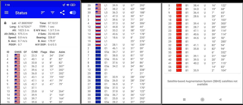
Sensors 2022, 22, 1289                                                                                            2 of 23

                         and trucks [18], the autonomous control of forestry vehicles [19], and many more Precision
                         Forestry and Industry 4.0 purposes [20].
                               The possible applications of satellite-based position determination in the forestry sector
                         are diverse and steadily increasing. Therefore, the frequency of use of GNSS technology in
                         current forestry activities is quite high, although it varies between countries [6].
                               However, GNSS position determination based on trilateration requires a free and
                         unobstructed signal connection to the satellites in order to carry out several precise pseudo-
                         range measurements. With its canopy, which influences, blocks, or reflects the satellite
                         signals to a particular extent, the complex forest environment poses a unique challenge to
                         being able to determine exact positions [21–23].
                               In the scientific literature, many limitations and influence factors of finding a precise
                         GNSS position under the canopy have been identified and examined. These include
                         forest types [8,24–27], dense canopies [28–32], the water content of leaves and wooden
                         material [33,34], topography [32,35], local atmospheric conditions [36], temperatures below
                         freezing [16,21], seasons [21], wind [21], humidity [27,37], and many more.
                               The recipient’s environment is of crucial importance. Below the canopy, the Multipath
                         effect can significantly affect the accuracy of the positioning. Multipath occurs when a
                         satellite signal arrives at a receiver’s antenna via more than one different path. Objects
                         such as trees near the receiver antenna can reflect GNSS signals and, thus, create secondary
                         propagation paths. These secondary path signals can interfere with reaching the receiver
                         directly from the satellite. Multipath affects both pseudo-range and carrier-phase measure-
                         ments [38]. Particularly, thin branches and leaves as strong Multipath reflectors favour the
                         Multipath, reduce the position accuracy, and disturb the signal-to-noise ratio [21,39,40]. In
                         particular, deciduous forests and evergreen forests, where there are tall trees with thick
                         trunks as well as dense crowns, cause high Multipath and poor reception [41]. However,
                         special antennas, for example, polarised or choker ring antennas, which smartphones do
                         not have, can reduce the Multipath effect in shielded areas [23,42].
                               Multipath error studies of smartphone positioning accuracy in an anechoic chamber
                         in a controlled environment demonstrated that the quality of observations collected in the
                         anechoic chamber is significantly better than those collected in the natural environment [43].
                         Performance studies of a Xiaomi Mi 8 smartphone related to pseudo Multipath and noise
                         compared to a geodetic receiver found that the smartphones resulted in higher Multipath
                         and lowered C/N0 values than geodetic receivers [44]. Several studies found that Multipath
                         effects can account for about 50% of the horizontal position error observed [42,45,46].
                               The combination of multi-frequency reception and the relatively new possibility
                         of reading out raw GNSS observation data from smartphones makes it possible to use
                         different positioning variants. Thus, code- and carrier-phase observations can be analysed
                         and thereby Multipath can be minimised.
                               The positioning accuracy of a GNSS module on a smartphone was typically between 3
                         and 5 m under good Multipath conditions and over 10 m under harsh Multipath environ-
                         ments [47]. However, measurements of smartphone positioning detected rapid Multipath
                         variations over time [48,49]. Even when positioning was conducted using geodetic class
                         receivers, considerable variability in positioning accuracies occurred due to the Multipath
                         effect [50]. Additionally, the satellite constellations also do not behave in the same way.
                         For example, Galileo measurements have a smaller Multipath error compared to GPS
                         measurements [44].
                               Several studies have been carried out to investigate the positioning accuracy based
                         on smartphone observations. The accuracies that can be achieved depend crucially on the
                         positioning algorithm used, and results usually reach in the range of metres to decime-
                         tres [51–53]. A study by Pensyna et al. [54] in 2014 showed that cm solutions are possible
                         in principle, using smartphone antennas, and that the high Multipath sensitivity of smart-
                         phones can be overcome. Studies in recent years have shown that centimetre accuracies
                         using smartphones are achievable under good conditions (open sky) [55–57], even with the
                         same (Xiaomi Mi 8) or comparable (Huawei P30) smartphones as used in this study [58,59].
Sensors 2022, 22, 1289 3 of 23
A decisive factor in reception quality and position accuracy under forest conditions is
the number of available, tracked, and usable satellites. The assumption is that the more
satellites in view/track, the better the position accuracy. However, the achievable accuracy
also depends on many other factors, such as the distribution of the satellites, the evaluability,
and the correction of the delay error variables [21,22,60,61].
In the early research stages, only the American NAVSTAR-GPS (navigation signal
timing and ranging—global positioning system) and/or the Russian system GLONASS
(globalnaja nawigazionnaja sputnikowaja sistema) could be used. Most modern smart-
phones now support a multi-constellation of satellite systems and use a combination to
determine their position; therefore, they can also use the European GNSS system GALILEO,
the Chinese GNSS system BeiDou, the Indian RNSS (Regional Navigation Satellite System)
system NavIC (Navigation with Indian Constellation), and the Japanese RNSS system
QZSS (Quasi-Zenith Satellite System).
Additionally, the number of satellites that can be used for positioning and the number
of frequencies available from the satellites has increased significantly over the last few
years, contributing to higher satellite availability, especially in the forest. Figure 1 shows
the available operational GNSS/RNSS satellites as a function of years and systems for the
years 1978 to 2020.
125
NAVSTAR GPS
GLONASS
BEIDOU
Number of operational GNSS satellites
Galileo
100 NAVIC
QZSS
75
50
25
0
Year
Figure 1. Available operational GNSS/RNSS satellites as a function of years and systems from 1978
to mid-2020 (data sources: [62–69]).
The number of active satellites available for positioning has tripled since 2002 and
has doubled since 2010, with 130 active by the end of 2020. This increase is mainly due to
the implementation of the GALILEO and BeiDou systems. A total of 130 active potential
satellites was available for positioning the receivers at the beginning of 2021. The current
quantitative installation of satellite systems is thus largely complete [62–69]. This high
number is particularly noticeable under difficult conditions (e.g., under a forest canopy), as,
in most cases, sufficient satellites can now be used in a favourable constellation and thus
the DOP (dilution of precision) values are also very good.
GNSS satellite signals may be reflected by the ground and thus influence position
determination. When using a ground plane to avoid reflections, higher accuracies are
possible under overshadowing [70]. Moreover, an accurate determination of horizontally
arranged smartphones can possibly reach other values [53,71]. However, both use cases
do not correspond with the practical application of smartphones in the forest, where a
smartphone is usually held vertically by the user.
Due to the many position-influencing variables under the forest canopy, the signals’
correction plays a decisive role (differential global navigation satellite system: DGNSS),
achieving an accurate position. However, the various correction signals are often notSensors 2022, 22, 1289 4 of 23
available over a wide area in many areas. The satellite-based augmentation systems
(SBASs) are often blocked in forest conditions due to their primarily geostationary satellite
altitude and are only available to a limited extent. The same applies to radio- or internet-
based DGNSS systems (e.g., SAPOS and BEACON), whose geographical coverage varies
greatly and is not comprehensive [16].
In 2018, a chipset from Broadcom BCM47755 that supports two frequencies each for
three satellite systems (GPS L1 C/A, L5; QZSS L1, L5; Galileo E1, E5a) was launched; it can
also be used on mobile phones [72]. The Xiaomi MI 8 smartphone was the first to use this
new multi-frequency chipset, and it was launched in June 2018 [73]. The additional use
of the E5a/L5 frequencies is intended to reduce the Multipath effect (i.e., the reflection of
satellite signals from trees, etc.) and provides the opportunity to make ionospheric-free
linear combinations between observations of two frequencies to eliminate the ionosphere
effect, thus improving accuracy [49,74,75]. The reception quality of the Xiaomi Mi 8, as the
first dual-frequency smartphone, is particularly often studied [44,51–53,71,74,76–79].
Moreover, a second-generation dual-frequency GNSS chip, the BCM47765, was re-
leased by Broadcom in May 2020. It can track new L5 signals, the new BeiDou-3 constella-
tion B2a signal, and signals from the NAVIC constellation. This will increase the availability
of dual-frequency signals on three different GNSS constellations instead of two [80–82].
Gradually, other important manufacturers also offered dual-frequency chips, including
Qualcomm with the Snapdragon X24 LTE modem and HiSilicon with the Kirin 980 system-
on-a-chip with high energy efficiency and a form factor for intelligent data processing and
FinFET transistor design [82]. Therefore, the number of multi-frequency GNSS smartphones
is increasing. Currently, numerous dual-frequency GNSS smartphones are already available.
A search resulted in 211 smartphones from 14 different manufacturers [83]. Development
is progressing, and there are currently 24 types of smartphones on the market that support
three frequencies with BeiDou. In addition, there is progress towards the use of even more
free frequencies. There are already five smartphones from Huawei on the market that can
use four BeiDou frequencies (B1I + B1B + B1C + B2a) and seven smartphones that can
use three Galileo frequencies (E1 + E5a + E2b) [83] (as of 27.12.2021). Therefore, it can be
assumed that smartphones’ positioning accuracy in forests will continue to increase, and
that there is a need for further research in this field.
This research aims to determine the relatively new multi-frequency multi-constellation
smartphones’ absolute GNSS accuracy and compare it with single-frequency multi-constellation
smartphones as well as a differential corrected multi-frequency multi-constellation geodetic
GNSS receiver (code and phase measurement) under the forest canopy. The position is
to be determined based on the position supplied to the user in real time by the Android
Location API of the smartphone.
2. Materials and Methods
2.1. Study Design and Examined Smartphones
This study assesses the accuracy of different single- and multi-frequency GNSS re-
ceivers integrated into smartphones under a forest canopy. The experiment examined the
accuracy achievable in a static reception status. The priority was the practical evaluation of
the internal GNSS receivers’ capabilities under a forest canopy.
A total of 10 smartphones with integrated GNSS modules and one geodetic receiver
were used in the tests. The smartphones were selected according to different criteria. In
order to obtain a comparison, older models and newer models, as well as models with
single and dual-frequency receivers and models that are used in practice (’outdoor/forest
mobile phones’), were combined. Table 1 shows an overview of the smartphones and GNSS
receivers used in the empirical experiment. It includes the different manufacturers, models,
model release years, and the used chips’ hardware (construction) year, from 2015 to 2019.
Additional information is provided about the used Android versions and the different API
levels from 23 to 29, with all smartphones updated to the highest possible version.Sensors 2022, 22, 1289 5 of 23
Table 1. Overview of the smartphones and GNSS receivers used in the empirical experiments (1 Num-
ber of Frequencies; 2 Release Year/GNSS NMEA Hardware Year/Android Platform/API-Level).
ID Manufact. Type Model NF 1 RY/HY/P/API 2
Mi8 Xiaomi Mi 8 Mi 8 2 2018/2018/10/29
Mi8pro Xiaomi Mi 8 Pro MI 8 Pro 2 2018/2018/10/29
Mi10 Xiaomi Mi 10 light M2002J9G 2 2020/2019/10/29
P20 Huawei P20 EML-L29 1 2018/2016/10/29
P40 Huawei P40 ANA-NX9 3 2020/2018/10/29
S5 Samsung S5 SM-G900F 1 2014/2013/6/23
A7 Samsung A7 SM-A750FN 1 2018/2016/10/29
XC4 Samsung Xcover 4 SM-G390F 1 2017/2015/9/28
XC4s_a Samsung Xcover 4s SM-G398FN 1 2019/2016/10/29
XC4s_b Samsung Xcover 4s SM-G398FN 1 2019/2016/10/29
Trimble Trimble Geo7x TrimbleGeo7x 2
Four out of ten smartphones provide dual-frequency reception (Xiaomi Mi 8, Mi 8 Pro,
and Mi 10) with their internal chips, and one smartphone provides triple-frequency recep-
tion (Huawei P40). It was often reported from practice that exactly the same smartphone
types often lead to very different results. Therefore, a comparison was also made between
identical models (Samsung Xcover 4s) and smartphones with the same GNSS chip (Xiaomi
Mi 8 and Mi 8 pro).
Figure 2 shows an overview of the different types of smartphones used and their
ability to use the different GNSS constellations and frequencies, as well as the possibility to
use double-frequency or triple-frequency reception.
GNSS-System GPS GLONASS GALILEO BAIDOU NAVIC QZSS
Signal L1 L5 G1 E1 E5a B1C B1l B2a L5 L1 L5
Central Frequency 1.575 1.176 1.602 1.575 1.176 1.575 1.561 1.176 1.176 1.575 1.176
Model mHz
Xiaomi Mi8 x x x x x x x x
Xiaomi Mi8pro x x x x x x x x
Xiaomi Mi10 x x x x x x x x x
Huawei P20 x x x
Huawei P40 x x x x x x x x x x x
Samsung A7 x x x
Samsung S5 x x x
Samsung XC4 x x x
Samsung XC4s x x x
x dual-band frequency x tri-band-frequency
Figure 2. Overview of the different types of smartphones used and their ability to use the different
GNSS constellations and frequencies.
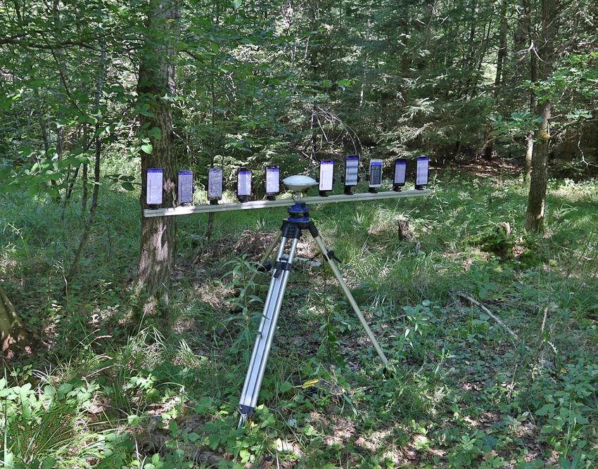
2.2. Experimental Setting
In order to be able to carry out the measurements simultaneously, a holder was built
for the 10 smartphones and the geodetic GNSS receiver. A 1.5 m long aluminium bar was
mounted on a tripod. The two-channel Trimble Geo7x GNSS receiver’s external antenna
was installed in the middle, precisely above the survey point. Attached to the bar were
smartphone holders with an exact distance of 14 cm. The experimental design was aligned
consistently east to west, and smartphones were placed with a known defined offset in an
east–west orientation. Thus, the position of every smartphone could be derived relative to
the known survey point. The smartphones were arranged vertically in the holders.
The tripod was aligned precisely with the centre of the survey point using a plumb
bob. The height above the ground varied somewhat due to the settings and the micro-relief,
but it was approximately 1 m.
Figure 3 shows the arrangement used in these experiments, including the names of the
smartphone models used. The experimental setup was placed exactly over a terrestrially
surveyed geodetic survey point where the exact absolute position was known.Sensors 2022, 22, 1289 6 of 23
Short names:
Mi10 P40 P20 XC4s_b XC4 Trimble MI8pro A7 S5 XC4s_a Mi8
east
west
NMEA names:
M2002J9G ANA-NX9 Trimble SM-
EML-L29 SM-G398FN SM-G390F MI 8 Pro SM-A750FN SM-G398FN Mi 8
Geo7x G900F
Survey marker
Figure 3. Arrangement of the smartphones and the Trimple GNSS receiver above the survey marker
under a forest canopy. The smartphones were placed with a known defined offset in an east–
west orientation.
The studies took place in Germany in the federal states of Bavaria, Saxony, and Baden-
Württemberg. In total, measurements were carried out at 15 different study sites. The tree
species, the relief, the degree of canopy closure, and the foliage conditions varied among
the study spots. Only sites under a canopy and with official terrestrial survey points of
which the absolute accuracy was known were used. Table 2 shows the characteristics of the
different study sites.
The locations of the survey points in the forest were acquired from the official survey
authorities of the respective federal states. It was a challenge to find points in the forest
under a canopy with sufficient accuracy and suitability. In addition, a wide range of
real forest structures should be represented. This included both old and young stands in
hardwood, softwood, and mixed wood. Only 8% of the potential points were used for
the study. According to the surveying offices of the various federal states, the absolute
accuracies of the used survey points were less than 5 cm.
The coordinates of the permanently marked survey points were determined in each
case as local terrestrial geodetic connection measurements of fixed trigonometric points.
The coordinates are available in the official reference system for the federal states of Baden-
Württemberg and Bavaria (ETRS89/UTM zone 33N; EPSG: 25832), as well as for the federal
state of Saxony (ETRS89/UTM zone 33N (EPSG: 25833). The GNSS coordinates of the
smartphones and the geodetic receiver were available in WGS 84 (EPSG: 4326) and were
converted into ETRS89/UTM zone 33N (EPSG: 25832) for further processing and analysis
by transformation method (ETRS89 to WGS 84 (1); EPSG: 1149) using a Python script
(package ESRI arcpy).Sensors 2022, 22, 1289 7 of 23
Table 2. Characteristics of the different study sites (SP ID: Official ID of the local survey point;
FS: Location in federal state [B: Bavaria; BW:Baden-Württemberg; S: Saxony]).
ID Latitute Longtitute SP ID FS Conditions and Main Obstacle for Reception
1 48.0651990 11.5655060 7935 0188 B Beech dominated mixed forest, 13 m to forest road, closed dense
canopy, trees > 15 m
2 48.0502484 11.4392006 7934 0040 B Beech dominated mixed forest, 6 m to forest road, closed canopy
with crown gaps towards the road, trees > 12 m
3 48.0499501 11.4425390 7934 0041 B Beech dominated mixed forest, 10 m to forest road, closed canopy,
trees > 15 m
4 47.9962202 7.7610121 8012 031 BW Beech dominated deciduous forest, closed canopy, trees > 20 m
5 48.0378690 7.9720488 7913 163 00 BW Fir dominated mixed forest, northeast slope, closed canopy,
trees > 30 m
6 48.0269512 7.9535119 7913 134 00 BW Beech dominated mixed forest, closed canopy, trees > 25 m
7 47.8880590 8.1546365 8114 034 BW Spruce, pure stand, medium dense canopy, trees > 25 m, natural
rejuvenation > 4 m
8 47.8885525 8.1558580 8114 034 01 BW Spruce, windthrow area with large open sky areas, trees > 25 m
9 47.8907364 8.1619936 8114 269 BW Spruce, pure stand, 6 m to forest road, closed canopy with crown
gaps towards the road, trees > 25 m
10 47.9650230 7.8463260 8013 025 BW Beech dominated mixed forest, northward slope, closed canopy,
trees > 25 m
11 50.6989621 13.1634072 5244000100 S Spruce, pure stand, hilltop, canopy with greater gaps, trees > 20
12 50.6971547 13.1657759 5244000101 S Spruce, pure stand, 2 m to forest road,closed, very dense canopy,
crown gaps towards the road, trees > 12 m
13 50.7170483 13.1437748 5244002201 S Beech dominated mixed forest, closed canopy with small gaps,
trees > 20 m
14 50.6900370 13.1400410 5344006100 S Spruce, pure stand, 4 m to forest road, closed canopy, crown gaps
towards the road, trees > 25 m,
15 50.7026740 13.1225790 5244001201 S Spruce, pure stand, 5 m to forest road, closed canopy with crown
gaps towards the road, trees > 25 m
The positions in these experiments were provided directly by the internal GNSS
receivers of the smartphones and were not externally corrected in any way.
Static positions were measured on the tripod at each study site point for at least
10 min. The smartphones were offline before and during the measurements. In addition,
the position service was switched off before the actual measurement. The location detection
and the recording function in the app were then switched on in sequence from east to west,
and the measurement was carried out. At the end of the measurement, the location option
of the smartphones was switched off in the same order.
2.3. Data Capturing and Processing Software
All 10 smartphones were equipped with the Android operating system in the latest
version available for the respective mobile phone and with all current updates. However,
the phones had different versions of the Android system and especially different filters
integrated in the analysis of the GNSS raw data, which can affect the analysis of the data.
In this study, GNSS NMEA data provided by the Android Location API are used. As
part of the Android 6 (‘Marshmallow’) system, the Location API 23 allows access to the
NMEAListner class, providing basic NMEA sentences used in this study. As part of the
Android 7 (‘Nougat’) system, the Location API 24+ provides GNSS raw and computedSensors 2022, 22, 1289 8 of 23
information via Android classes. Therefore, e.g., GNSS clock, receiver time, clock bias,
received satellite time, and code- and carrier-phase data are accessible. The Location API
24+ is backwards compatible. Therefore, used functions, such as NMEA sentences, are
also available in higher versions [75,84]. With the NMEA data provided by the smart-
phone’s Android Location API, single point positioning (SPP) can be assumed for internal
determination of the position.
The app ‘GPStest’ from the developer ‘barbeauDev’ was used to record the GNSS
data. The program code is open source and available on GitHub [85]. For comparison
purposes, all smartphones used the same version (3.6.4) of the app ‘GPStest’, and all of the
settings of the app were also exactly the same. The app captures the GNSS NMEA (data
specification for communication for GNSS/RNSS data by the National Marine Electronics
Association) standard data of the mobile phone and prevents the mobile phone from
switching off even during long measurements. Furthermore, it is simply structured and has
the possibility to display real-time information about the current measurement, especially
for the GNSS and SBAS satellites and the different frequencies used. This is essential for a
functional check during the capture. Figure 4 shows the Android app ‘GPStest’ used to
capture the GNSS data in this study. The app shows the real-time meta and positioning
data. Additionally, real-time data about the different satellite identifications, constellations,
receiving frequencies (CF), signal-to-noise ratios (C/N0 ), flags, elevations, and azimuth
angles are displayed and stored.
Figure 4. Example smartphone GNSS data from the Android app ’GPStest’ used for capturing and
live control of the GNSS data in this study.
The logged data were further processed as follows:
1. The data from the app ’GPStest’ were stored in the GNSSlog in a text file format on the
smartphone. In addition to the header’s metadata, this also contains the navigation
message data, raw GNSS measurements data, location fix data, and NMEA data.
2. The data were subsequently read out asynchronously from the individual smart-
phones and stored in a file system.
3. NMEA data were used to analyse the measured position and satellite data. The app
used, ’GPStest’, stores all data in a joint log file containing NMEA data, metadata,
navigation data, RAW data, and others. Using a parser, ’GNSS2NMEA’, programmed
by the author in Python, the “correct” NMEA data were extracted from the GNSS log
file, verified, and saved as a pure NMEA text file. This process was performed for
each mobile phone and each recording separately with a batch process.
4. The NMEA data were parsed and written into an MYSQL database. For this purpose,
a Python program, ’NMEA2DB’, and database schema created by the author [16,21]
were adapted and used to extract the relevant positioning and satellite data from the
NMEA file. Some challenges were the different NMEA interpretations, the differentSensors 2022, 22, 1289 9 of 23
NMEA 0183 versions (v2.3; v4.10; v4.11) of the smartphone manufacturers, and the
NMEA standard’s different dialects. In particular, the handling of the standard with
the different satellite systems and the multi-frequency data was very different. The
parser was elaborately and explicitly adapted to the different smartphone models and
their NMEA characteristics. The following NMEA 0183 datasets were analysed and
the data were stored: (a) RMC: Recommended Minimum Sentence C; (b) GGA: Global
Positioning System Fix Data; (c) GNS: GNSS fixed data; (d) GST: GNSS Pseudorange
Error Statistics; (e) GSV: Satellites in view); and (f) GSA: GPS DOP and active satellites.
The parsing process steps were as follows:
(a) Automatic identification of the smartphone types/names. If the type/name was
identical (i.e., Samsung XCOVER 4s a and b), this step was manually completed.
(b) Extraction of all information from the relevant NMEA sentences.
(c) Generation of SQL statements of the parsed data.
(d) Execution of the SQL statements to transfer the satellite and position informa-
tion into a MYSQL GNSS database [16].
5. The position data and the satellite data were separately stored in two different
tables (‘pos’ and ’sat’) that are clearly linked in a one-to-many relationship using
measurement-GUID, a receiver (e.g., smartphone), and a UTC timestamp. The tables
were fully indexed and query-optimised.
The GNSS data from the Trimble Geo7x were processed separately. Post-processing
using the Trimble GPS Pathfinder Office correction service was performed in the office.
Afterwards, the corrected position data was loaded into the database. The UTC timestamp
can synchronise the positioning data with the smartphone positioning data.
2.4. Data Analysis
The data were read from the GNSS database and analysed within the statistical
software R (GNU). The satellite data used, the frequency bands, and the carrier-to-noise
density ratio C/N0 were extracted and analysed.
Plausibility analysis of the positions provided by the smartphones was carried out.
This was necessary because, for example, the Huawei P40, in some cases, first supplies
the coordinates of the previous ‘old’ position in the NMEA string after switching on the
position data option until a new position is known. In these cases, the ‘old’ data were
not considered.
The measured positions were adjusted along the longitude for the distance by which
the smartphones deviated in the west–east direction on the holder. This was performed
using a view table directly on the database. The adjusted distances are as follows: Mi 10
light: 70 cm; Huawei P40: 56 cm; Huawei P20: 42 cm; Samsung Xcover 4s b: 24 cm; Samsung
Xcover 4: 13 cm; Xiaomi Mi 8 pro: −14 cm; Samsung A7: −28 cm; Samsung S5: −42 cm;
Samsung Xcover 4s a: −56 cm; and Xiaomi Mi 8: −70 cm.
In this study, only the horizontal error was examined. This was calculated for each
individual measurement at 1 s intervals, considering the position error in relation to
the respective geodetic survey point. For the evaluation of the absolute error, various
mathematical ratios were then derived. In addition to the arithmetic mean and standard
deviation, different circular error probable (CEP) values (25, 50, 75, 95, and 99.7), the DRMS
(distance root mean square), and the 2DRMS (twice distance root mean square) of the
error were derived. The circular error probable (CEPx x) is defined as the radius of a circle
centered on the true value that contains xx% q of the actual GNSS measurements. It is based
on the 2D-error of the GNSS measurement: ( xi − xsp )2 + (yi − ysp )2 , where xsp /ysp are
the x/y coordinates of the specific survey point. Equation (1) shows the calculation of
the DRMS.
s
q ∑iN=1 ( xi − xsp )2 ∑ N (yi − ysp )2
DRMS = σx2 + σy2 = + i =1 . (1)
N NSensors 2022, 22, 1289 10 of 23
A Wilcoxon Rank Sum Test was carried out to test whether the different receivers
significantly affected the results. The p-value was adjusted using the continuity correction
method of ‘holm’ [86]. The significance threshold was set at 0.05.
3. Results
Measurements were carried out at 15 different study sites; 24 measurements of ap-
proximately 10 min with a recording interval of 1 Hz were made at each position. During
the study, a total of 158,150 position data and 4,753,910 satellite data were recorded, parsed,
and stored in the GNSS database. The data were collected in different seasons.
3.1. Different Signal Reception
The reception quality and the difference between the position accuracies of the various
smartphones examined depends strongly on the number, type, and quality of the satellite
signals received and used to determine the GNSS position.
Table 3 shows the average number of satellites that were used for position determi-
nation per constellation and the frequency bands over the entire data collection session.
It is clear that four of the ten tested smartphones also used multiple frequency bands in
the field to determine their positions (Xiaomi MI 8, Xiaomi MI 8 Pro, Xiaomi Mi 10 light,
Huawei P40). The Huawei P40 used three bands. Older smartphones, such as the Samsung
S5 and the Huawei P20, only used two, and the different Samsung XCOVER 4/4s and the
Samsung A7 only used three constellation/band combinations. Newer multi-frequencies
models, on the other hand, used five (Xiaomi MI 8/8 Pro), seven (Xiaomi Mi 10 light), or
even eight (Huawei P40) constellation/band combinations to determine the GNSS position.
Table 3. Number of active satellites used for fixed positions per constellation and frequency bands
(FBand) given as an average over the entire data collection session.
GPS GLONASS BAIDOU GALILEO Sum
Smartphone
L1 L5 G1 B1C B1l B2a E1 E5a Sat’s FBands
Xiaomi MI 8 6.0 1.8 4.0 3.8 3.5 13.8 19.0
Xiaomi MI 8 Pro 4.7 1.6 3.5 3.0 1.7 11.3 14.6
Xiaomi Mi10 light 7.5 3.4 6.4 5.4 4.3 6.6 6.5 25.8 40.0
Huawei P20 7.9 1.6 9.6 9.6
Huawei P40 6.1 1.6 8.3 7.9 5.3 5.4 7.2 7.1 29.4 48.8
Samsung A7 7.9 4.2 5.0 17.1 17.1
Samsung S5 6.5 2.8 9.2 9.2
Samsung Xcover 4 7.2 5.0 4.4 16.6 16.6
Samsung Xcover 4s A 7.7 4.4 4.3 16.4 16.4
Samsung Xcover 4s B 7.6 4.5 4.1 16.2 16.2
The benefit of applying L5/E5a/B2a code pseudoranges may be reliably verified but
varies significantly between the different constellations. A careful inspection of the table
allows us to conclude that the relative ratio of multi-frequency use by NAVLSTAR GPS
satellites is much smaller than that of the other constellation types (BeiDou, Galileo), due
to the small number of GPS satellites that provide signals on the L5 frequency band. The
average number of acquired GPS satellites on L5 was much lower than that on L1 for all
smartphones. The L5 frequency of the GPS NAVSTAR satellites was received by only 26%
(Xiaomi Mi 10 light) to 45% (Huawei P40) of the satellites. The lower number of satellites
with the L5 band can be explained by its lower availability compared to the availability of
the L1 signal. With the B3a/B1l band of the BeiDou constellation, in contrast, the ratio was
between 68% and 80%. In the Galileo constellation, except for Xiaomi Mi 8 pro (56%), the
E5a band was used for almost every satellite for which E1 was also used. The proportions
vary from 92% (Xiaomi Mi 8 pro), to 98.5% (Xiaomi Mi 10 light), to 98.6% (Huawei P40). The
average number of acquired GPS satellites on L5 is much lower than that on L1 for all dual-
frequency smartphones by an average from 1.6 to 3.4 satellites. Therefore, smartphones that
are able to use the second or even third frequency of the BeiDou (B2a, B1) or Galileo (E5a)
systems have a potential advantage to eliminate ionosphere interference using the B2a/E5a
code pseudoranges, as classical dual-frequency ionosphere-free linear combinations do.Sensors 2022, 22, 1289 11 of 23
It is particularly remarkable that newer, more frequently used smartphones tended
to use significantly more satellites for positioning. Older smartphones (Samsung S5 and
Huawei P20) used on average 9.2 or 9.6 active satellites, while modern smartphones (Xiaomi
Mi 10 light and Huawei P40) used up to 25.8 or 29.4 satellites for positioning at the same
time in the experiment. If one also considers the frequency bands, the number increases to
40.0 and 48.8 bands, respectively. This means that a much higher potential was exploited,
and more information was used to determine the position.
Even smartphones that were identical or almost identical in construction differed from
each other. However, the two identical single-frequency Xcover 4s smartphones showed
very slight, non-significant differences. On the other hand, the Xiaomi MI 8 and Xiaomi
MI 8 Pro, which were equipped with the same GNSS chip, differed significantly from each
other in some cases. This is particularly evident when using the E5a frequency, of which
the Xiaomi MI 8 Pro used the 1.7 (56%) band and the Xiaomi MI 8 the 3.5 (92%) band. The
Xiaomi MI 8 used an average of 19 frequency bands to determine its position, whereas
the Xiaomi MI 8 Pro used only 14.6 frequency bands under the same recording conditions.
This significant difference cannot be explained without a deeper analysis of the hardware
and software.
A more detailed representation of the satellites in use and their proportions can be
seen in Figure 5. It shows the relative frequency in relation to the satellites in use (not the
frequency bands of the received positions).
The relative frequency of the distribution of the satellites for the smartphones is highly
diversified. In Figure 5, blue indicates smartphones with multi-frequency capabilities,
and red indicates smartphones that can only receive the L1/G1/E1/B1c bands. The
recorded time periods, the time stamps, and the recording conditions are identical for
all smartphones.
It is evident that the new models ,such as the Huawei P40 and the Xiaomi Mi 10
light, use significantly more satellites for positioning, with the former having more than
20 satellites in use over almost the entire study period. This is more than the maximum
number for most other smartphones. One explanation for this is the improved hardware,
which brings about improved performance with new generations of smartphones and thus
a higher number of satellites that can be used. Figure 6a clarifies this relationship using
the satellites in use, which were measured in this study in relation to their release dates. In
particular, the newer models from 2020 show very high values. This is mainly due to the
consistent simultaneous use of all four available constellations. If the different frequency
bands are added, this difference becomes even more apparent (Figure 6b).
It is noticeable in Figure 5 that the Xiaomi Mi 8 and the Xiaomi Mi 8 pro both have
two-peaked distributions. Both smartphones had partial initialisation problems below
the canopy and provided no or only limited position data over more extended periods
during the measurements. This was mainly a result of the different canopy cover. If
the overshadowing were stronger, then the NAVSTAR GPS would dominate in terms of
position detection and Galileo. BeiDou satellites are hardly used anymore, resulting in
a number of satellites in use, which are similar to those used by the older models. The
Xiaomi Mi 8 pro uses either between 5 and 12 satellites or between 18 and 23 satellites, and
the values in between are almost non-existent. The Xiaomi Mi 8, in particular, often had
problems with positioning under the canopy, which only provided positions on average
around 77% of the time to the other smartphones under the canopy (see Table 4).Sensors 2022, 22, 1289 12 of 23
30% Xcover 4s_b
P20
Relative frequency in %
Xcover 4
S5
20%
A7
Xcover 4s_a
P40
Mi 10 light
Mi 8 Pro
10%
Mi 8
0%
5 10 15 20 25 30 35
Satellites in use
Figure 5. Relative distribution of satellites in use by the smartphones studied. Blue indicates
smartphones that have multi-frequency capabilities, and red indicates smartphones that can only
receive the L1/G1/E1/B1l bands.
35 50
P40 45 E5a
30 Number of active satellites for frequ. band
40
Mean number of active satellites
Mi10light
E1
E5a
25 35
B2a
30 E1
20
XC4 A7 B1l
XC4sa
XC4sb
25 B2a
15 Mi8
20 B1C B1C
Mi8pro
E5a
S5 P20
10 15 E1 E5a G1 E1 B1C E1 E1
E1 G1
10 B1C L5 B1C
B1C G1 B1C B1C
B1C B1C
5 L5 L5
5 L5
L1 L1 L1 L1 L1 L1
L1 L1 L1
L1
0 0
2014 2015 2016 2017 2018 2019 2020 2021
Release date
(a) (b)
Figure 6. (a) Correlation between the release date and the mean number of active satellites used
by the smartphones in the whole experiment; (b) distribution of active satellites for the different
frequency bands (different colors: different frequency bands).
In the satellite distribution of the Huawei P 20, a phenomenon occurs that signifi-
cantly lowers every uneven satellite value. This cannot be explained technically and will
undoubtedly affect the smartphone’s evaluation software.
In Figure 7, the skyplots illustrate the mean carrier-to-noise-density ratio C/N0 of
satellites in use for the different smartphones as a function of azimuth and elevation.
There is a big difference between the satellites used for the same measurements. This is
particularly evident in the comparison between the Huawei P40 (Figure 7a) and the Huawei
P20 (Figure 7b).
In contrast to high-grade receivers and antennas, there is only a low C/N0 dependence
on satellite elevation in smartphone GNSS receivers and a large number of drops in C/N0
that are unexpected for high elevations. These can be seen in Figure 7 for most smartphones.
These results indicate that the commonly used elevation-dependent function may not be
optimal for GNSS observation weighting and that a C/N0 -dependent function, as already
proposed [87], would be more appropriate.
It is noticeable that the Xiaomi Mi 10 very often has interruptions in the paths of the
active satellites. Therefore, it can be assumed that the smartphone’s evaluation softwareSensors 2022, 22, 1289 13 of 23
evaluates and changes the satellites used to determine the position much more differentially
and dynamically.
3.2. Static Accuracy
Figure 8 illustrates the relative cumulative GNSS accuracy distribution of different
smartphones under a forest canopy measured at different known survey points. The
multi-frequency smartphones are shown in the various shades of blue, the single-frequency
smartphones in the various shades of red, the GNSS reference in olive, and the mean values
in green.
It becomes clear that there are significant differences between the smartphones. How-
ever, the differences between GNSS receivers vary, so it is difficult to identify the most
appropriate mathematical indicator. At this point, the DRMS error will be used for com-
parability. Table 4 represents the characteristic values of the absolute two-dimensional
position deviation of the different smartphones and GNSS receivers used in the empirical
experiments.
Table 4. Characteristic values of the absolute two-dimensional position deviation of the differ-
ent smartphones and GNSS receivers used in the empirical experiments. (MF: multi-frequency;
x̄: arithmetic mean; SD: standard deviation; CEPxx : circular error probable of xx%; CEP: circular
error probable of 50%; DRMS: distance root mean square; 2DRMS: twice distance root mean square,
n: number of measurements).
x̄ SD CEP25 CEP CEP75 CEP95 CEP99.7 DRMS 2DRMS
Receivers MF n
(m) (m) (m) (m) (m) (m) (m) (m) (m)
Geo 7X Yes 2.49 2.11 0.57 1.42 4.76 5.46 6.97 3.26 6.52 12,096
P20 No 5.22 4.54 2.82 4.72 6.67 10.58 37.64 6.92 13.83 12,270
P40 Yes 6.28 3.58 4.03 5.03 7.97 13.38 16.00 7.22 14.45 12,645
MI 8 Yes 5.85 4.19 3.11 4.08 7.52 14.27 22.53 7.20 14.39 9492
MI 8 Pro Yes 6.75 5.26 3.34 5.77 8.51 16.34 30.46 8.55 17.10 11,780
Mi10 light Yes 3.73 2.62 1.79 3.28 5.39 7.89 16.10 4.56 9.13 12,627
Xcover 4 No 10.44 10.19 4.50 8.05 11.97 41.99 47.25 14.59 29.17 12,333
Xcover 4s_a No 6.90 3.48 4.06 6.02 9.49 13.25 13.25 7.73 15.46 12,224
Xcover 4s_b No 7.20 3.44 4.34 7.22 9.22 12.27 19.72 7.98 15.96 12,254
A7 No 5.86 3.70 3.40 5.17 7.06 15.80 17.74 6.94 13.87 11,691
S5 No 6.73 4.41 3.26 6.20 8.14 16.72 22.55 8.05 16.09 11,926
MultiF No No 7.07 5.77 3.75 6.02 8.79 13.64 41.99 9.13 18.25 72,698
MultiF Yes Yes 5.62 4.16 2.79 4.73 7.32 13.38 24.04 6.99 13.98 46,544
All 6.14 5.17 3.08 5.03 8.03 13.38 41.99 8.03 16.05 131,338
Under a forest canopy, reception conditions differ significantly in contrast to open
areas. Nevertheless, the high-quality corrected Geo 7X (DRMS: 3.26 m) is the most accurate,
followed by the Xiaomi Mi 10 light (DRMS: 4.56 m). The others rank from highest to lowest
in the following order: Huawei P20 (DRMS: 6.92 m), Samsung A7 (DRMS: 6,94 m), Xiaomi
Mi 8 (DRMS: 7.20 m), Huawei P40 (DRMS: 7.22 m), Xcover 4sA (DRMS: 7.73 m), Xcover
4sA (DRMS: 7.98 m), Samsung S5 (DRMS: 8.05 m), Xiaomi Mi 8 Pro (DRMS: 8.55 m), and
Xcover 4 (DRMS: 14.59 m). The outdoor smartphone Xcover 4 is far behind with highly
inaccurate values.
Based on the measurements of the study, the multi-frequency smartphone receivers
(DRMS: 6.99 m) achieve a significantly higher position accuracy under overshadowing
than the single-frequency smartphones (DRMS: 9.13 m). It is worth noting that the date
of manufacture may also have an influence. A newer release date and thus potentially
improved hardware is not a direct prerequisite for improved reception in a forest. Figure 9a
illustrates the correlation between the release date and the absolute position error (CEP). TheSensors 2022, 22, 1289 14 of 23
differences (not taking into account the poorly performing Samsung Xcover 4 smartphone)
are tiny, and the single-frequency smartphones reach a DRMS value of 7.23 m.
0 0 0
10 10 10
30 30 30
60 60 60
270 90 270 90 270 90
180 180 180
(a) Huawei P40 (b) Huawei P20 (c) Xiaomi Mi 10
0 0 0
10 10 10
30 30 30
60 60 60
270 90 270 90 270 90
180 180 180
(d) Xiaomi Mi 8 Pro (e) Xiaomi Mi 8 (f) Samsung A7
0 0 0
10 10 10
30 30 30
60 60 60
270 90 270 90 270 90
180 180 180
(g) Samsung XC4 (h) Samsung XC4s A (i) Samsung XC4s B
0
10
30
60 50
C/N0 [dB-Hz]
270 90 40
30
20
180
10
(j) Samsung S5
Figure 7. Carrier to noise density ratio C/N0 skyplots of the GNSS signals collected by the different
smartphones.Sensors 2022, 22, 1289 15 of 23
100%
90%
80%
Relative cumulative distribution in % 70%
60%
50%
Receiver
40% MI 8
MI 8 Pro
Mi10 light
30% P20
P40
A7
20% S4
Xcover 4
Xcover 4s_a
10% Xcover 4s_b
Geo 7X
All
0%
0 1 2 3 4 5 6 7 8 9 10 11 12 13 14 15
Position Error in m
Figure 8. Relative cumulative GNSS accuracy distribution of different smartphones under different
forest canopy conditions. Blue indicates smartphones that have multi-frequency capabilities, and red
indicates smartphones that can only receive the L1/G1/E1/B1l bands.
9 9
XC4 XC4
8 8
CEP of absolute positioning error in m
CEP of absolute positioning error in m
XC4sb XC4sb
7 7
S5 S5
XC4sa XC4sa
Mi8pro Mi8pro
6 6
A7 P40 A7 P40
P20 P20
5 5
Mi8 Mi8
4 4
Mi10light Mi10light
3 3
2 2
1 1
0 0
2014 2015 2016 2017 2018 2019 2020 2021 5 10 15 20 25 30
Release date Mean number of active satellites
(a) (b)
Figure 9. Correlation between the absolute position error (CEP) and (a) the release date and (b) the
mean number of active satellites used by the smartphones used in the experiment.
If another index is used, such as the CEP (median), this ratio is put into perspective
again, whereby the error difference of multi-frequency smartphones, 4.73 m, is significantly
lower than that of the classic single-frequency smartphones, 6.02 m. (see Figures 8 and 10
and Table 4).Sensors 2022, 22, 1289 16 of 23
15
14
13
12
11
Position Error in m 10
9 n = 12,333
med = 8.05
n = 12,254
8 med = 7.22
n = 11,926
7 n = 11,780
n = 12,224
med = 6.2
med = 6.02
med = 5.77
n = 11,691
6 n = 12,270
n = 12,645
med = 5.17
med = 5.03
med = 4.72
5 n = 9492
med = 4.08
n = 12,627
4 med = 3.28
3
n = 12,096
2 med = 1.42
1
0
Geo 7X Mi10 light MI 8 P20 P40 A7 MI 8 Pro Xcover 4s_a S5 Xcover 4s_b Xcover 4
Receiver
Figure 10. Boxplot of the absolute position error of the different receivers. Blue indicates smartphones
that have multi-frequency capabilities, and red indicates smartphones that can only receive the
L1/G1/E1/B1l bands.
A correlation between the absolute position error (CEP) and the number of active
satellites is not clear (Figure 9b). The Huawei P20 and the Huawei P40, in particular, clearly
demonstrate this, as the P40 uses about three times the number of satellites to determine
its position while having similar positioning accuracy. Therefore, other factors greatly
influence the precision of the positioning. However, the most accurate smartphone (Xiaomi
Mi 10 light) also has a very high number (25.8) of active satellites.
Table 5 shows a Wilcoxon Rank Sum Test to compare the different receivers relating
to the absolute position errors. All the accuracy differences between the smartphones are
significant, except for the Huawei P40 and the Xiaomi Mi 8 Pro. The identical (Samsung
Xcover 4s) or quasi-identical (Xiaomi Mi 8/8 Pro) ones, on the other hand, are significantly
different.
Table 5. Wilcoxon Rank Sum Test with continuity correction and ’holm’ correction between the
absolute positioning errors of the studied smartphones (p-values, α = 0.05).
Geo 7X Mi 8 MI 8P MI 10 P20 P40 A7 S5 XC4sa XC4sb
Xiaomi Mi 8 0.00
Xiaomi Mi 8 Pro 0.00 0.00
Xiaomi Mi 10 light 0.00 0.00 0.00
Huawei P20 0.00 0.00 0.00 0.00
Huawei P40 0.00 0.00 0.88 0.00 0.00
Samsung A7 0.00 0.00 0.00 0.00 0.00 0.00
Samsung S5 0.00 0.00 0.00 0.00 0.00 0.00 0.00
Samsung Xcover 4s_a 0.00 0.00 0.00 0.00 0.00 0.00 0.00 0.00
Samsung Xcover 4s_b 0.00 0.00 0.00 0.00 0.00 0.00 0.00 0.00 0.00
Samsung Xcover 4 0.00 0.00 0.00 0.00 0.00 0.00 0.00 0.00 0.00 0.00
4. Discussion
This study investigated the static GNSS positioning accuracy of novel multi-frequency
multi-constellation smartphones and compared them with single-frequency and geode-Sensors 2022, 22, 1289 17 of 23
tic receivers under forest conditions. The acquisition of detailed and spatially accurate
positioning data is required in several forest business applications.
It can be assumed that the data provided by multi-constellation, dual-frequency
smartphone receivers can reach a higher GNSS accuracy under a forest canopy based on
the increase in the signal availability and the elimination of ionospheric error.
Under open sky conditions and special GNSS raw data analyses, such as carrier phase
observations, after successful ambiguity fixation, centimeter-level accurate positioning with
multi-frequencies smartphones is possible [59,70,78,88].
The current study has focused on the position solution that smartphones deliver
directly and in difficult conditions in a forest. Further studies show that the accuracy for
point measurements under open area conditions are between two and six times higher
compared to point measurements under forest conditions [89]. The reception qualities
vary considerably between the different reception conditions (study sites). It is challenging
to quantify the environmental conditions under the canopy of a forest that influences
reception [21], and available methods, such as free-sky classification, are only conditionally
suitable for describing a correlation with position accuracy [16]. Therefore, it is difficult to
generalise the results of different GNSS studies under forest conditions. This is particularly
true for smartphones as receivers, as even smartphones of the same design deliver different
positions to the same reception conditions under a canopy. Even the number of satellites
in use alone cannot be considered reliable for estimating position accuracy. Other studies
have also come to this conclusion [70].
In static GNSS accuracy studies, the question of how long or how many fixed points
should be recorded is always addressed during the experiment setup. The duration of the
GNSS recording under a forest canopy has a significant influence on the absolute error
and the precision [90,91], and a longer averaging of position values can usually improve it
significantly [61,90,92].
In the present study, a recording of at least 10 min with an recording interval of 1 Hz
was made at each position. The chosen (optimal) recording time for the experimental
determination of static positions has been evaluated differently by different authors and
ranges from 2 to 120 min [27,28,92–95]. However, even 2 min of waiting time for GNSS
positioning with a smartphone is too long in practice, as working people usually do not
want to wait long for a more accurate position. It is therefore difficult to determine an
optimal recording time.
All 15 study sites were considered together in the present study, and this mix was
regarded as a representative forest sample. However, there are significant differences in
accuracy between the different canopy cover intensities. If the different canopy covering
ratios are taken into account [8,70,71], the results can be considered in a more differentiated
way. Therefore, further studies should include objective forest stand metrics to compare
and correlate different overshadowing situations. A possible method is the Fisheye photos
classification algorithm [96], which was used in [16,21,23].
As the reception conditions under large trees are particularly challenging, this is also
seen in the considerable variation of error values for all GNSS receivers (Figure 10). There
are receiving conditions, especially on the north slope in heavily overshadowed, dense
forest, where all types of receivers face challenging conditions for deriving an accurate
position. There is a strong significant correlation between canopy density and positional
accuracy [21,23], and the accuracy achievable can range from millimeters to tens of meters
depending on the operating environment [17].
The dual-frequency smartphones performed best on average across all recordings in
this study. It is difficult to determine whether this is due to the multi-frequency technology
or progress based on the development of antennas, more sensitive sensors, or improved
algorithms. However, there are many differences between individual smartphones. The
first multi-frequency smartphone, the Xiaomi Mi 8, achieved a higher accuracy (DRMS:
7.22 m) in this study than the average of the single-frequency smartphones (DRMS: 9.13 m),
but individual single-frequency smartphones, such as the Samsung A7 (DRMS: 7.22 m)Sensors 2022, 22, 1289 18 of 23
or the Huawei P20 (DRMS: 7.22 m), achieved a slightly higher accuracy than the Xiaomi
Mi 8, as well as the Xiaomi Mi 8 pro (DRMS: 8.55 m). In other studies which compare
smartphones under a canopy, the Xiaomi Mi (RMSE: leaf-on: 6.13 m, leaf-off 4.10 m, open
arena 2.23 m) outperformed the Huawei P20 lite (RMSE: leaf-on: 8.12 m, leaf-off: 11.44 m,
open arena: 3.44 m) [71]. Compared to studies of older smartphone generations under
a leafy canopy, widespread accuracies also occur (RSMExy : ZTE Blade: 11.45 m; LG G2
Android 4.4: 9.3 m; LG G2 Android 5.0: 6.74 m; Sony M4 Aqua: 7.48 m; Lenovo Yoga 8:
4.96 m) [89]. However, it must also be considered that the results of the different tests only
offer an indication and cannot be directly compared with each other. The studies did not
occur under the same conditions, and there are no objective indicators available to evaluate
the environmental reception situation.
The multi-frequency Xiaomi Mi 10 clearly stands out compared to single-frequency
smartphones. It has a 31% lower absolute error under the CEP and a 34% lower absolute
error under the CEP95 compared with the best single-frequency phone. In general, it
can be assumed that multi-frequency mobile phones can improve reception under forest
conditions. At the same time, it should be noted that this is highly dependent on the
capabilities of the individual smartphone and should not be over-generalised. For example,
the developers at Xiaomi have significantly improved the reception quality of the Xiaomi
Mi 8 and Xiaomi Mi 8 Pro in the Xiaomi Mi 10. In other studies, the Xiaomi Mi 9 showed
lower accuracies than the Xiaomi Mi 8 [87]. The overall potential as a combination of
available frequencies, hardware, and software will certainly not be exhausted yet. Further
research studies on upcoming smartphones should provide more information.
It should be expected that smartphones with identical or very similar design will
produce identical results. Therefore, a comparison was made between identical models
(Samsung Xcover 3s) and smartphones with the same GNSS chip (Xiaomi Mi 8 and Mi 8 Pro).
The two identical Samsung XCover 4s models which were tested, on average, used almost
the same number of active satellites for the fixed position (Figures 3 and 6b) but differed
slightly in the distribution of satellite frequency (Figure 5) and in the positional accuracy
(CEP: 6.02 m vs. 7.22 m; DRMS: 7.73 m vs. 7.98 m). The differences between the two tested
Samsung XCover 4s cannot be explained, as they are identical in construction, were bought
together, and were treated absolutely the same in terms of software.
The two Xiaomi smartphones (Mi 8 and Mi 8 pro) should have accessed the same
satellites and acquired the same position data, as they have the same GNSS chip (Broadcom
BCM47755) installed. The similarity between the two smartphones is that they are the
only smartphones with a two-top distribution of satellites in use (Figure 5). The positional
accuracy was significantly different (CEP: 4.08 m vs. 5.77 m; DRMS: 7.20 m vs. 8.55 m)
However, the differences that occurred confirmed the practitioners’ statements that
more significant deviations can occur with absolutely identical phones. A more detailed
explanation for this cannot be derived from these studies. These potential differences and
the associated fluctuations in position determination must be considered when using and
testing these smartphones and should be investigated more closely in the future. Therefore,
if possible, two identical smartphones should be constantly tested.
In principle, it should be assumed that newer smartphones with improved hardware
and software also achieve higher positioning accuracy. However, the results of this study
do not allow a generalised statement to be made (Figures 6a and 9a). Newer hardware and
software do not necessarily imply higher accuracy. In [97], it was found that, under open
sky conditions, the Samsung S4 and Samsung S5 achieved a higher accuracy than their
predecessors, the Samsung S6 and Samsung S7. Other studies found that the Xiaomi Mi 8
had a higher accuracy in GPS- and multi-GNSS solutions than its successor, the Xiaomi
Mi 9 [87]. The present study comes to similar conclusions, especially when comparing the
Huawei P20 with its successor, the Huawei P40. In the case of the manufacturer Xiaomi,
the Xiaomi Mi 10 light, the latest tested mobile phone, is also the one in the current study
with the best positioning accuracy under the forest canopy.You can also read