US26 (POWELL BLVD): SE 99TH AVE TO EAST CITY LIMITS (Outer Powell) Benefit-Cost Analysis (BCA) Description and Factors
←
→
Page content transcription
If your browser does not render page correctly, please read the page content below
US26 (POWELL BLVD): SE 99TH AVE TO EAST CITY LIMITS (Outer Powell)
              Benefit-Cost Analysis (BCA) Description and Factors

The purpose of the Outer Powell Project proposed for RAISE Program Grant funding is to
provide the last dollars needed to construct multimodal improvements that create a safe and high
quality transportation network in a community area of persistent poverty and historically
undeserved. A multimodal transportation network that provides enhanced travel safety, access
and options for all users regardless of travel mode, race, age, disability status or income level.

The project corridor is located in a disadvantaged and underserved section of Oregon’s largest
urbanized area. The existing transportation infrastructure is characterize by:
   • The absence of sidewalks or bike lanes
   • Outdated signals at intersections
   • The absence of signalized intersections or mid-block signalized pedestrian crossing
       providing safe and convenient access to businesses, services, and activities
   • Inadequate lighting, impeding visibility of motorists, bicyclists and pedestrians
   • A vehicle travel lane configuration that undermines the safety of cross lane turns and
       promotes traffic back-ups
   • The absence of transit features that support and enhance transit use by residents in an area
       that demonstrate a high level of transit dependency
   • Crash and injury rates two to three times higher than statewide rates for similar urban
       corridors.

The RAISE grant funded project would widen the existing 3.25 mile corridor roadway to include
a two-way center turn lane. It provides six to eight foot sidewalks and protected bike lanes on
both sides of corridor roadway. It will rebuild 220 Americans with Disabilities Act (ADA) ramps
to meet current standards and construct ten mid-block pedestrian crossings using Rectangular
Rapid Flashing Beacons (RRFBs). The project will replace and upgrade traffic signals and add
fiber communications. It will replace eight inch traffic signal heads with twelve inch signal heads
and install improved intersection and roadway lighting. The project will reconfigure all driveway
accesses to improve safety for all modes. It will improve 38 transit bus stops, add bus pullouts
and concrete bus pads. It will upgrade the corridor storm water system to reduce flooding and
provide storm water treatment. It will repave all travel lanes.

Together project components will provide a transportation network that provides high quality
and safe travel options for motorists, bicyclists, pedestrians and mobility impaired individuals.
As developed, the project priority is on enhancing user safety and enhancing travel mode choice
and opportunity. The project was developed as a single undertaking with construction activities
occurring simultaneous in physically separated sections. Any increase or reduction in
construction improvements or activities will be equally applied throughout the project length of
3.25 miles.

The baseline for this project is No-Build or no completion of proposed project improvements.
Expected future conditions and costs assuming no improvements are compared with the benefits
and costs associated with the completion of the proposed project (Build alternative). As proposed

                                                                                                    1
for RAISE grant funding, the US26 (POWELL BLVD): SE99TH VE TO EAST CITY LIMITS
(Outer Powell) project has an estimated project cost of $107.9 million in 2020 dollars. The
completed project has a Net Present Value (PV) of $13,518,755 and a Benefit-Cost Ratio of
1.15 at a 7 percent discount rate.
The full BCA excel worksheets can be found in excel file attachment (Outer Powell RAISE
Grant Final.xlsx).
The primary amount of funding for the proposed project was made available by the Oregon
Legislature with the direction that the funding be used for the design and construction of safety
and mobility improvements that benefit all users regardless of travel mode. In light of the given
availability of funding and directed priority for safety and mobility improvements in an
underserved and socioeconomic disadvantaged community area, the development and design of
the project has lacked the normal collection and preparation of various project data. While data
was collected and available for crashes and injuries, average daily traffic volumes, modal
distributions, and expected vehicle traffic growth, no attempt was made to develop any formal
calculations regarding project impacts with and without completed project improvements on
such things as travel times and hours of delay. Vehicle traffic growth was expected to be the
same with and without project improvements. While there was an acknowledged expectation that
under the no-Build alternative, the future volume of vehicle traffic would exceed travel lane
capacity, no attempt was made to calculated impacts on vehicle travel times or hours of delay
other than a cursory expectation that travel times would lengthen and a nominal value of hours of
delay would result.
The Outer Powell project BCA was completed using methodology consistent with the most
recent guidance developed by the U.S. Department of Transportation (Benefit-Cost Analysis
Guidance for Discretionary Grant Program, March 2022 (Revised).
Factor Descriptions
Factors used or developed to make the benefit-cost calculations are described below, along with
their sources. In the project worksheets, all monetized factors are converted into 2020 dollars and
discounted according to DOT BCA Guidance of 7 percent and 3 percent for Carbon offsets.
Construction cost estimates and schedule: Construction cost estimates by broad category are
presented in the table starting in column O and row 9 of the “Cost 1” worksheet. Construction
cost estimates by broad category and schedule are presented in the table starting column H and
row 9.
Capital cost information: The project cost estimates in the “Cost 1”worksheet are expressed in
2020 dollars and discounted 2020 dollars in row 30 of the “7% Discounting” worksheet. The
discount rate is seven percent and is first entered in cell B27 of the “7% Discounting” worksheet.
Cost savings (pavement): The project falls within ODOT’s significant and on-going pavement
preservations programs. Construction will displace one round of pavement preservation in its
opening year. The calculations in row 33 of the “7% Discounting” worksheet are based on the
2assumption of pavement preservation costs of $309,000 per lane mile in 2020 dollars (see rows
1-5 of the “Cost 1” worksheet. As the completed project will rebuild the existing roadway, the
new pavement is expected to last 25 years. The project will only displace one cycle and cost
saving only apply to existing lane-miles.
Maintenance costs: $7,693 per new lane mile per year. Source: Oregon Department of
Transportation’s FYs 2016-2018 non-overhead average annual maintenance costs on a per lane-
mile basis, converted to 2020 dollars from 2017. This figure is first entered in “Inputs
Worksheet” cell N41. This figure is then applied to the New Lane-Miles entries of the “Cost 1”
worksheet in the “7% Discounting” worksheet.
Reduced vehicle operating costs: Project is not expected to have a noticeable effect on vehicle
operating costs other than reduced fuel consumption from avoided vehicle, pedestrian and bike
crashes.
Emissions per gallon: The factors listed below were calculated by solving for tailpipe
emissions per gallon using Tables 3-26, 3-27, and 3-28 of The Economic and Societal Impact of
Motor Vehicle Crashes, 2010 (Revised), National Highway Traffic Safety Administration, DOT
HS 812 013, May 2015 (revised). The tailpipe emissions per gallon were added to the upstream
emissions per gallon, then short tons were converted to metric tons to produce the following
estimates:
• CO2 – 0.010984958 metric tons per gallon
• NOX – 1.78E-05 metric tons per gallon
• PM2.5 – 1.505E-06 metric tons per gallon
• SOX – 1.084E-06 metric tons per gallon
These estimates are entered in “Inputs Worksheet” cells J43:J48.
Fuel price: $3.62 per gallon. Source: “AAA Gas Prices” estimate for Oregon on 06/30/2021.
Figure has been converted to 2020 dollars. This factor is first entered in “Inputs Worksheet” cell
R41. Reflecting the absence of travel time savings and reduced vehicle hours of delay for other
than that associated with reduced crashes and a nominal expected hours of delay value under the
no-Build scenario, fuel prices have de minims impact on BCA calculations (increasing or
decreasing fuel prices by $1 dollar impacts net present values by less than a tenth of a percent.
Reduction in GHG (CO2) emissions: Damage costs per metric ton varies over time, starting at
$58 in 2027 and increasing to $80t in 2046, the last year of our analysis. Future damages from
carbon are discounted at 3%. Source: Benefit Cost Analysis Guidance for Discretionary Grant
Programs, U.S. Department of Transportation, March 2020 (Revised), Table A-6. This factor is
first entered in “Inputs Worksheet” Row 113, columns S-AL. The 3% discounting is entered on
the “7% Discounting” worksheet, cell B18.
Reduction in NOX emissions: $17,100-18,100 damage costs per metric ton for our analysis
period 2027-2046. Source: Benefit Cost Analysis Guidance for Discretionary Grant Programs,
3U.S. Department of Transportation, March 2022 (Revised), Table A-6. This factor is first entered
in “Inputs Worksheet” Row 116, columns S-AL.
Reduction in PM2.5 emissions: $827,400-$867,600 damage costs per metric ton for our analysis
period 2027-2046. Source: Benefit Cost Analysis Guidance for Discretionary Grant Programs,
U.S. Department of Transportation, March 2022 (Revised), Table A-6. This factor is first entered
in “Inputs Worksheet” Row 114, columns S-AL.
Reduction in SO2 emissions: $46,500-$49,100 damage costs per metric ton for our analysis
period 2027-2046. Source: Benefit Cost Analysis Guidance for Discretionary Grant Programs,
U.S. Department of Transportation, March 2022 (Revised), Table A-6. This factor is first entered
in “Inputs Worksheet” Row 115, columns S-AL.
Proportion of vehicle types: a) Passenger vehicles – 94.5% b) Commercial Trucks 4%, and
1.5% for buses breakdown provided by are department staff based on area Automatic Traffic
Recorder. Figures first used in cells D45 and D47 of “Inputs Worksheet.”
Hourly value of time savings: For passenger vehicles, used the “All Purposes” estimate of
$17.80 per hour from Table A-3. For truck drivers, used the estimate of $32.00 per hour from
Table A-3. For bus drivers, the figure is $33.60 per hour from Table A-3. Source: Benefit Cost
Analysis Guidance for Discretionary Grant Programs, U.S. Department of Transportation,
March 2022 (Revised), Table A-3. These factors are first entered in “Inputs Worksheet” cells
D42, D44 and D46 where they are scaled by expected ridership associated with the use of the
area’s 38 bus stops.
Improved peak hour reliability: Equivalent to the reduction in peak vehicle hours of delay
(VHD). Source: Estimates of the value of reliability have a wide range, vary around values of
VHD, and are highly correlated with congestion. Note that no benefits are assumed for off-peak
reliability improvements (excepting off-peak crashes).
Induced travel: Significant induced travel by pedestrians and bicycles is likely to be positive
due to the fact that high quality pedestrian and bicycle facilities and enhanced safety
infrastructure are being added where none previously existed. The Portland area is nationally
known for the proportion of population that walk and bike. Induced travel by pedestrians and
bicycles resulting from project completion is calculated as the difference between pedestrian and
bicycle travel based on expected increased yearly growth rate after project completion compared
to pedestrian and bicycle travel based on an expected yearly growth rate of 1.08 percent divided
by 2. With the completion of project improvements, the expected area’s growth rate of pedestrian
and bicycle travel is expected to be in the neighborhood of 3.28 percent per year (Bike and
Pedestrian Volumes and Forecast Scenarios, prepared by B. Chaney P.E. based on “K21178
Traffic Operations Analysis Memo” dated 2/19/2021 and source counts from 11/19/2014 (see
“Bike-Ped Forecasts” worksheet). Reflecting a general absence of project BCA related
4quantitative and validated data, use of an expected 3.28% growth rate is limited to calculations of
Mortality Reduction and Facilities Improvement Benefits.
Safety: The primary purpose of the Outer Powell project is to increase vehicle, pedestrian and
bicycle safety and provide infrastructure enhancements that benefit pedestrians, bicyclist and
mobility impaired residents. Expected crashes are based on 2016-2020 data. The project area is a
noted high crash and injury corridor. Crash rates through the project area are two to three time
the statewide crash rate average for similar corridors. Over time, crashes and injuries are
expected to increase at the same rate as average daily traffic (see “Inputs Worksheet” cell I20).
The crash reduction factor (CRF) applied to each modal alternative is presented in cells B67,
B69 and B85 of the “Inputs Worksheet.” These factors are constant for the analysis period, and
apply separately to vehicle, pedestrian and bicycle safety improvements. The source for CRFs
used are CRFs provided by project traffic engineers (email included at the end of this document)
and are from ODOT’s All Roads Transportation Safety Program Appendix
(https://www.oregon.gov/odot/Engineering/ARTS/CRF-Appendix.pdf).
CFRs used for vehicles, pedestrians and bicyclists reflect project focus on infrastructure
improvements that enhance safety. CFRs presented in cells B67, B76 and B85 reflect
combinations of two CFR reduction benefits that are considered to have no or little overlap effect
on the primary identified CFR. For example, the primary expected reduction of vehicle crashes
and injuries resulting from the installation of a 2-way left lane on a 2-lane urban arterial is 39%,
installing lighting on roadway is expected to further reduce expected crashes and injuries by
upwards of 28%; adding say half the lighting benefit to the 2-way turn lane benefit produces an
expected CFR with a value of upwards of 53%. CRF value identified in B85 is 51%.
To demonstrate the improved safety figures, crash tables showing the improvement from no-
build to build alternative are shown in the “Expected Crashes” worksheet. Under the no-build
baseline, vehicle, pedestrian and bike crashes are expected to grow over time from their 5-year
annual average at the same rate of growth as vehicle traffic. Under the no-build scenario, this
implies that over the twenty years following project completion, vehicle fatalities and injury
crashes will total upwards of 1,700 (cells T132 & U132 “Expected Crashes” worksheet),
pedestrian injuries will total upwards of 70 (cell U89 “Expected Crashes” worksheet) and bicycle
injuries will total nearly 20 (cell U46 “Expected Crashes” worksheet). These calculations can be
found in the “Expected Crashes” worksheet”, in the tables in R2 – W132. With construction,
vehicle fatalities will fall from 19.1 to 9.4, vehicle fatalities and injuries will fall from 1693.8 to
830.0, pedestrian injuries will fall from 67.0 to 20.3 and bicycle injuries will fall from 19.1 to
8.1. (Calculations in “Expected Crashes” worksheet), tables in cells G2-W132). These tables are
illustrative, the calculations for the BCA Analysis are based on March 2022 (Revised) BCA
Guidance and occur in the “Inputs Worksheet.”
Calculation of improved reliability due to crash reduction follows the same methodology as
improved peak hour reliability above. Sources: The values applied are from Tables A-1 and A-2
of Benefit Cost Analysis Guidance for Discretionary Grant Programs, U.S. Department of
5Transportation, March 2022 (Revised), and are found in cells AB59-AB64 of the “Inputs
Worksheet.” Reduced hours of delay resulting from reduced crashes are based on the NHTSA,
The Economic and Societal Impact of Motor Vehicle Crashes, 2010 (Revised), Table 3-21
applied to comparable functional classes. These are listed in AC59-AC64 of the “Inputs
Worksheet.” Safety-related data is brought together and calculated in the “7% Discounting”
worksheet.
Yearly Facilities Improvements Benefits: As previously noted, a primary purpose of the
project is to make infrastructure improvements that improve not only the safety but the comfort
and quality associated with walking and cycling. With the increased attractiveness of walking
and cycling, more people can be expected to walk and bike demonstrating revealed preference
values, a benefit which has been monetized in the most recent revisions of US DOT’s Benefit-
Cost Analysis Guidance for Discretionary Grant Programs, March 2022 (Revised), Tables A-8
and A-9. Under the no-Build alternative, pedestrian and bicycle travel is assumed to grow at the
1.08 percent vehicle rate of growth for the entire BCA analysis period. Under the Build
alternative, pedestrian and bicycle travel grow at the vehicle rate of growth until project
completion in 2026, beginning in 2027 the expected annual rate of growth increases to 3.28%
The vehicle growth rate factor is first entered in “Inputs Worksheet” cell E20. For the calculation
of bicycle and pedestrian benefits resulting from facilities improvements and revealed preference
values, the annual growth rate of 3.28 percent was applied to both expected pedestrian and
bicycle traffic beginning in year 2027 of the Build scenario and first entered in cells AM90 and
AM103 of the “Inputs Worksheet”. Construction of 6-foot sidewalks and BCA guidance values
for walking and cycling trip distances trips are combined with annual growth values and
recommend monetized trip values to produce yearly revealed preference values presented in cells
AN95-BG95 and AN108-BG108 and combined in cells AN109-BG109 of the “Inputs
Worksheet”. Seven percent discount values for yearly mortality reduction benefits for walking
and cycling are presented in cells K53-AD53 of the “7% Discounting” worksheet.
Yearly Mortality Reduction Benefits: With the increased attractiveness of walking and
cycling, more people can be expected to walk and bike leading to increased physical activity
which correlates with reduction in mortality, a benefit which has been monetized in the most
recent revisions of US DOT’s Benefit-Cost Analysis Guidance for Discretionary Grant
Programs, March 2022 (Revised,) Table A-12. . Under the no-Build alternative, pedestrian and
bicycle travel is assumed to grow at the 1.08 percent vehicle rate of growth for the entire BCA
analysis period. Under the Build alternative, pedestrian and bicycle travel grow at the vehicle
rate of growth until project completion in 2026, beginning in 2027 the expected annual rate of
growth increases to 3.28%
The vehicle growth rate factor is first entered in “Inputs Worksheet” cell E20. For the calculation
of bicycle and pedestrian benefits resulting from facilities improvements and mortality reduction
features, the annual growth rate of 3.28 percent was applied to both expected pedestrian and
bicycle traffic beginning in year 2027 of the Build scenario and first entered in cells AM64 and
6AM75 of the “Inputs Worksheet”. BCA guidance values for walking and cycling trip distances
as well as walking and cycling age ranges and percentage of induced trips are combined with
annual growth values and recommend monetized trip values to produce yearly mortality
reduction benefit values presented in cells AN68-BG68 and AN79-BG79 and combined in cells
AN80-BG80 of the “Inputs Worksheet”. Seven percent discount values for yearly facility
improvement benefits for walking and cycling are presented in cells K52-AD52 of the “7%
Discounting” worksheet.
Residual value: $12.5 million. Source: Amount is the present value of the straight-line
depreciated amount of the investment. Asset management experience indicates much roadway
construction does not depreciate or does not depreciate in a way that would affect the next 20
year planning horizon. Roadway construction is depreciated over 25 years. Structures are
depreciated over 75 years. Right-of-way, utility relocation, and engineering do not
depreciate. Calculations are made in the “Cost 1” worksheets. Conversion to present value
occurs in cell AF55 of the “7% Discounting” worksheet.
VHD reduction: Due to the predetermination of the project and its improvements, there was no
effort devoted to preparing project information on travel time or hours of delay impacts. There is
no assumed change in VHD due to this project except from the change in expected accidents for
pedestrians and bicycles reducing the delay during an accident, which is small. It is possible
there will be less delay due to separated and buffered bike lane and separated sidewalk where
none previously existed, as this means pedestrians and cyclists will not need to occupy lane
space to travel the corridor, but there has been no attempt to quantify this benefit.
7ODOT Crash Reduction Factors
These were all obtained from the ODOT All Roads Transportation Safety Program
(https://www.oregon.gov/odot/engineering/pages/arts.aspx) which has the CRF Appendix
(https://www.oregon.gov/odot/Engineering/ARTS/CRF-Appendix.pdf) for the work being included on
the project.
Pedestrians:
BP2: Provide Intersection Illumination (Bike & Ped) - ODOT CRF Value: 42%
• Reduction in Nighttime Pedestrian and Bicycle Crashes/All Injury Severities (Excluding PDO’s)
BP3: Install Urban Leading Pedestrian or Bicycle Interval at Signalized Intersections - ODOT CRF Value:
37%
• Reduction in Pedestrian and Bicycle Crashes/All Severities (Including PDO’s)
BP11: Install Rectangular Rapid Flashing Beacon with Median (3-Lane or More Roadway) - ODOT CRF
Value: 56%
• Reduction in Pedestrian Crashes/All Severities (Including PDO’s)
BP29: Add Sidewalk - ODOT CRF Value: 20%
• Reduction in Pedestrian – walking along Crashes/All Severities (Including PDO’s)
I9: Replace Urban Permissive or Protected/Permissive Left Turns to Protected Only - ODOT CRF Value:
99%
• Reduction in Left Turning Crashes/All Severities (Including PDO’s)
Bicycles:
BP2: Provide Intersection Illumination (Bike & Ped) - ODOT CRF Value: 42%
• Reduction in Nighttime Pedestrian and Bicycle Crashes/All Injury Severities (Excluding PDO’s)
BP3: Install Urban Leading Pedestrian or Bicycle Interval at Signalized Intersections - ODOT CRF Value:
37%
• Reduction in Pedestrian and Bicycle Crashes/All Severities (Including PDO’s)
BP6: Install Urban Green Bike Lanes at Conflict Points - ODOT CRF Value: 39%
• Reduction in Bicycle Crashes/All Severities (Including PDO’s)
BP21: Install Bike Signal - ODOT CRF Value: 45%
• Reduction in Bicycle Crashes at All Severities - (Including PDO’s)
BP23: Install Cycle Tracks – ODOT CRF Value: 59% - half of the project will have a cycle track
• Reduction in Bicycle Crashes/All Severities (Including PDO’s)
BP24: Install Buffered Bike Lanes - ODOT CRF Value: 47% - half of the project will have buffered bike
lanes
• Reduction in Bicycle Crashes/All Injury Severities (Excluding PDO’s)
8Motorized Vehicles:
H29/I1: Install Lighting at Intersection - ODOT CRF Value: 38%
• Reduction in Night Crashes/All Injury Severities (Excludes PDO’s)
H30: Install Lighting on a Roadway Segment - ODOT CRF Value: 28%
• Reduction in Night Crashes/All Injury Severities (Excludes PDO’s)
H33: Install Two Way Left Turn Lane on 2-Lane Road - ODOT CRF Value: 39%
• Reduction in Rear End Crashes/All Severities (Including PDO’s)
I4: Replace 8-inch Red Signal Heads with 12-inch - ODOT CRF Value: 42%
• Reduction in Angle Crashes/All Severities (Including PDO’s)
I9: Replace Urban Permissive or Protected/Permissive Left Turns to Protected Only - ODOT CRF Value:
99%
• Reduction in Left Turning Crashes/All Severities (Including PDO’s)
I17: Increase Triangle Sight Distance - ODOT CRF Value: 48%
• Reduction in All Crashes/All Injury Severities (Excluding PDO’s)
I29: Prohibit Right-Turn-On-Red - ODOT CRF Value: 9%
• Reduction in All Crashes/All Severities (Including PDO’s)
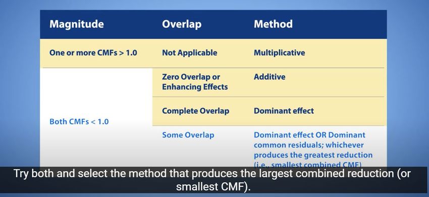
Combining CMFs
FHWA Website: https://www.cmfclearinghouse.org/
https://www.cmfclearinghouse.org/using_cmfs.cfm
9You can also read