TIGERS OF THE TRANSBOUNDARY TERAI ARC LANDSCAPE - Status, distribution and movement in the Terai of India and Nepal
←
→
Page content transcription
If your browser does not render page correctly, please read the page content below
TIGERS OF THE
TRANSBOUNDARY
TERAI ARC LANDSCAPE
Status, distribution and movement in the Terai of India and Nepal

Published by
               Global Tiger Forum (GTF)

               Designed by
               Aspire Design | www.aspiredesign.in

               Printed at
               New Delhi

               Credits WWF-India
               Report lead: Dr. Jimmy Borah

               Field work and analysis (contributors to the report):
               Pranav Chanchani, Dr. Kamlesh Maurya, Ashish Bista, Rekha Warrier,
               Shwetha Nair, Macson Almeida, Rohit Ravi and Ruchir Sharma

               Field assistance: Sher Singh Bisht, Ram Bharsoe Lal, Kuldeep
               Singh, Palu Chauhan, Santosh Kumar, Balwinder Singh, Data Ram,
               Dharminder.

               Report Preparation: Pranav Chanchani,
               Dr. Kamlesh Maurya and Dr. Jimmy Borah

               Administrative support: Dr. Mudit Gupta, Mr. Dabeer Hassan, Dr.
               Harish Guleria, Mr. Joseph Vattakaven and Dr. Dipankar Ghose

               Credits Nepal
               Report lead team: Dr. Maheshwar Dhakal, Mrs. Madhuri Thapa,
               Dr. Shant Raj Jnawali, Dr. Narendra M.B Pradhan and
               Dr. Naresh Subedi

               Field work: 268 people associated with DNPWC, DOF, NTNC, WWF
               Nepal, International Trust for Nature Conservation, Nepal Army,
               Nature Guide Association and students from Khwopa College, SchEMS
               College, CDES, Tribhuvan University, Institute of Forestry (IOF),
               Kathmandu University and KNIT Korea

               Data analysis (contributors to the report): Sabita Malla,
               Babu Ram Lamichhane, Gokarna Jung Thapa, Hemanta Yadav

               Report Preparation: Sabita Malla and
               Babu Ram Lamichhane

               Administrative support: Mr. Ravi Pratap Singh,
               Mr. Bhagwan Lal Shrestha, Mr. Bikram Kachhyapati, Mr. Khadga
               Pariyar, Mr. Prabin Rayamajhi, Mr. Buddhi Chaudhary, Mr. Ram
               Kumar Aryal, Mr. Bishwa Prakash Adhikari, Suman Malla, Mr.
               Shailendra Yadav, Mr. Sriram Ghimire, Mr. Ramji Thapa

               Cover Photo: NTNC/DNPWC
               Citation
               Chanchani P., Lamichhane B. R., Malla S., Maurya K., Bista A., Warrier
               R., Nair S., Almeida M., Ravi R., Sharma R., Dhakal M., Yadav S. P.,
               Thapa M., Jnawali S. R., Pradhan N. M. B., Subedi N., Thapa G. J.,
               Yadav H., Jhala Y. V., Qureshi Q., Vattakaven J. and Borah J. 2014.
© NTNC/DNPWC

               Tigers of the Transboundary Terai Arc Landscape: Status, distribution
               and movement in the Terai of India and Nepal. National Tiger
               Conservation Authority, Government of India, and Department of
               National Park and Wildlife Conservation, Government of Nepal
TIGERS OF THE
TRANSBOUNDARY
TERAI ARC LANDSCAPE
Status, distribution and movement in the Terai of India and Nepal

                   Partner collaborators
TIGERS OF THE TRANSBOUNDARY
               TERAI ARC LANDSCAPE
© NTNC/DNPWC
TABLE OF CONTENTS
FOREWORDS                                                                    vii

ACKNOWLEDGEMENTS                                                              ix

EXECUTIVE SUMMARY                                                             xi

1. INTRODUCTION                                                               1
    The Terai Arc Landscape                                                    1
    Motivation for Coordinated Monitoring and Joint Reporting                 5
    Objectives                                                                6

2. STUDY AREA                                                                 7
    Protected Areas in the Transboundary TAL                                 10
    Vegetation Types                                                         13
    Land Use and Management Practices                                        15
    Socio-Economic                                                            17
    Institutional Setup for Tiger Survey                                      17

3. FIELD METHODS                                                             19
    Tiger Habitat Occupancy                                                  19
    Tiger Population Estimation                                              19
    Capture-Recapture Sampling for Tigers                                    20
    Sampling Effort                                                          20
    Line Transect Surveys for Prey-Base Density Estimation                   21
    Data Analysis                                                            22

4. RESULTS                                                                   25
    Tiger Distribution                                                       25
    Individual Identification                                                27
    Tiger Abundance and Density                                              27
    Prey Density                                                             29
    Common Individuals Both in India and in Nepal                            29

5. DISCUSSION                                                                39
    Tiger and Prey Species Distribution and Abundance                        39
    Transboundary Connectivity Status and Tiger Movement Across Borders      40
    Fragmentation, Habitat Loss and Disturbance                              41
    Road and Railway Projects                                                42
    Protection, Poaching and Trade                                           43
    Habitat Quality, and Impacts of Hydropower Development and Climate Change 44
    Cattle Grazing                                                           45
    Encroachment                                                             46
    Human-Tiger Conflict                                                     47

                                                                                   iii
TIGERS OF THE TRANSBOUNDARY
 TERAI ARC LANDSCAPE

                         6. CONCLUSIONS AND RECOMMENDATIONS                                              49
                               Advocacy and Policy Interventions                                         50
                               Strategic Restoration and Management of Key Habitat, Corridors
                               and Connectivity                                                          51
                               Strengthening of Protection to Deter Poaching in Core, Buffer-Zone and
                               Corridor Areas                                                            54
                               Community Stewardship in Conservation                                     55
                               Research and Monitoring                                                   56

                         REFERENCES                                                                      59

                         APPENDIX - I                                                                    65
                               Site specific threats and recommendations for the tiger conservation in
                               transboundary TAL

                         APPENDIX - II                                                                   79
                               Tiger abundance and density estimates in the PAs of transboundary TAL

                         APPENDIX - III                                                                  81
                               Management regimes, roles and responsibilities in Nepal and India

                         APPENDIX - IV                                                                   82
                               Summary of camera trap efforts in transboundary protected areas

iv
LIST OF FIGURES AND TABLES
FIGURES
    Figure 1   Terai Arc Landscape                                           4
    Figure 2 Protected areas and corridors in Transboundary TAL             10
    Figure 3   Tiger habitat occupancy survey design, Terai Arc
               Landscape Nepal                                              19
    Figure 4 Line Transect survey design (Example from Parsa
             Wildlife Reserve in Nepal)                                     21
    Figure 5   Tiger of Chitwan NP (top) and Valmiki TR (bottom) showing
               100% match                                                   24
    Figure 6 Tiger capture locations in transboundary TAL (black
             dots: tiger capture location; red dots: camera location)       25
    Figure 7   Tiger habitat occupancy in Terai Arc Landscape, Nepal        26
    Figure 8 Site occupancy for tigers in a portion of the
             transboundary TAL in India                                     26
    Figure 9 Tiger density across the transboundary Terai Arc Landscape.    28
    Figure 10 Common Tigers between Chitwan NP, Nepal and Valmiki
              Tiger Reserve, India                                          30
    Figure 11 Movement of common tigers detected in Chitwan
              -Valmiki Complex                                              31
    Figure 12 Common tigers between Katerniaghat WLS and Khata
              corridor (Bardia)                                             32
    Figure 13 Tiger movement in Bardia-Khata-Katerniaghat complex           34
    Figure 14 Photographic evidence of the Khata male                       35
    Figure 15 Common tigers between Shuklaphanta WR and Laggabagga          36
    Figure 16 Tiger Movement between Shuklaphanta and Laggabagga            37
    Figure 17 The proposed road along the Indo-Nepal border in
              Terai Arc Landscape                                           42
    Figure 18 Block 1, Western block of Transboundary TAL                   51
    Figure 19 Block 2, Central block of Transborder TAL                     52
    Figure 20 Block 3, Eastern block of Transborder TAL                     53
    Figure 21 Block 4: Large patch of forest in Nepal TAL between eastern
              and central blocks                                            54

TABLES
    Table 1    Transboundary Protected Areas in Nepal and
               India in the Terai Arc Landscape                             8
    Table 2    Transboundary corridors in Nepal and India in the
               Terai Arc Landscape                                           9
    Table 3    Minimum tiger numbers and density estimates in PAs of
               transboundary TAL                                            28
    Table 4    Prey base density estimates in PAs of transboundary TAL      29

                                                                                 v
© NTNC/DNPWC
FOREWORD

           vii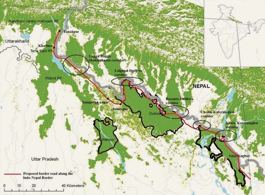
TIGERS OF THE TRANSBOUNDARY
 TERAI ARC LANDSCAPE

             FOREWORD

viii
We thank Dr. Rajesh Gopal of the National Tiger
ACKNOWLEDGEMENTS Conservation Authority (NTCA), Government
of India; Mr. Megh Bahadur Pandey and Mr.
Bishwonath Oli from Ministry of Forests and Soil
Conservation (MoFSC), Government of Nepal; Dr.
Ghana Shyam Gurung and Mr. Shiv Raj Bhatta, WWF Nepal; Dr. Sejal Worah, and Dr.
Dipankar Ghose, WWF-India and Mr. Ganga Jung Thapa, National Trust for Nature
Conservation (NTNC) for encouraging collaborative surveys, and for steering dialogue
between Nepal and India for tiger conservation in the Terai Arc Landscape.
In India, this study was made possible by the Uttar Pradesh and Bihar Forest
Departments. As well as granting research permits, they provided logistical support in
many other ways. We are grateful in particular to the Chief Wildlife Wardens of Uttar
Pradesh and Bihar, Dr. Rupak De and Mr. B. A. Khan, whose support was instrumental
for these studies. We also acknowledge support from the Field Directors of Dudhwa
Tiger reserve, Sh. Sailesh Prasad and Valmiki TR, Sh. Santosh Tewari, their kind
support interest. The Divisional Forest Officers Sh. Ganesh Bhat (Dudhwa), Sh. R.K.
Singh (Katerniaghat), Sh. A.K Singh (Katerniaghat), Sh. Kamaljeet Singh and Sh. Nand
Kishor (both Valmiki) and Sh. M. Mittal (Suhelwa) were all enthusiastically involved in
the monitoring and facilitated the work in numerous ways. We are also grateful for the
support of Range officers and foresters who aided us with the camera trapping. Finally,
credit is due to the many dedicated forest guards and watchers (too numerous to name
here) who proudly led us to tiger signs in their beats, and worked with us to ensure
that the monitoring exercise was implemented effectively and to meet its objectives.
These studies were funded by WWF-India (through grants from WWF-UK and WWF-
Sweden), and by the United States Fish and Wildlife Service. We thank Dr. B. R. Noon
for his involvement and support.
In Nepal, we highly appreciate the lead taken technical committee and Dr. Chiranjibi
Prasad Pokheral in overall co-ordination and field implementation. We are highly
grateful to Chief Conservation Officers, Mr. Fanindra Kharel, Chitwan National Park,
Mr. Jagannath Singh and Mr. Nilamber Mishra, Parsa Wildlife Reserve, Mr. Tulsi Ram
Sharma, Bardia National Park, Dr. Jhamak Bahadur Karki, Banke National Park and
Mr. Yuvaraj Regmi, Shuklaphanta Wildlife Reserve for leading the field survey team
and facilitating field work in various ways. We thank the District Forest Officers of all
14 Terai districts of the Terai Arc Landscape Nepal for extending their full support and
co-operation for field work. We are extremely thankful to our field team members: staff
of DNWPC, DOF, NTNC, WWF Nepal, Nepal Army, International Trust for Nature
Conservation (ITNC), Nature Guide Association, local communities from Buffer Zones
and Community Forests, and volunteer students from Tribhuvan University, Pokhara
University and Kathmandu University who spend numerous days and nights inside the
jungle to collect data. This study was made possible by the funding support we received
from USAID funded Hariyo Ban Program, DiCaprio Foundation, United States Fish and
Wildlife Service, WWF US, WWF UK and WWF Australia. We are highly thankful to
Ms. Judy Oglethorpe, Hariyo Ban Program, WWF Nepal and Mr. Netra Sharma, USAID
for financing the last minute funding crunch.
Mr. Ravi Singh, Secretary General and CEO of WWF-India, Anil Manandhar of
WWF Nepal, and Mr. Juddha Gurung, NTNC are thanked for their leadership and
ixTIGERS OF THE TRANSBOUNDARY
TERAI ARC LANDSCAPE
immense support for the program. Dr. Ghana Shyam Gurung and Mr. Shiv Raj
Bhatta of WWF Nepal, Dr. Sejal Worah and Dr. Dipankar Ghose, from WWF-India,
Dr. Eric Wikramanayake and Shubash Lohani from WWF US are thanked for their
instrumental role in building the program, and guiding its progress. We also thank
WWF Tigers Alive Initiative (TAI) for coordination and technical support provided as
and when required.
We thank Mr. Ravi Pratap Singh, Mr. Bhagwan Lal Shrestha, Mr. Bikram Kacchyapati,
and Mr. Prabin Rayamajhi and Buddhi Chaudhary of WWF Nepal and Ms. Emily
Gousen, WWF US for taking care of the entire painstaking job of procurement, customs
clearance and organizing the field logistics on time. We thank all the protected area
offices in Chitwan NP, Bardia NP, Parsa WR, Banke NP and Shuklaphanta WR;
NTNC field offices, Biodiversity Conservation Center, Bardia Conservation Program
and Shuklaphanta Conservation Program for mobilizing field logistics against all
odds. We thank Mr. Bishnu Prasad Thapaliya, Mr. Tika Ram Poudel, Mr. Rupak
Maharjan and Mr. Birendra Kandel in Chitwan NP, Mr. Lal Bahadur Bhandari in
Banke NP, Mr. Ramesh Thapa in Bardia NP, Mr. Manjur Ahmad and Mr. Pramod
Yadav in Parsa WR, Mr. Ram Kumar Aryal (BCC), and Mr. Rabin Kadariya (BCP) for
excellent co-ordination in the field. We thank Ms. Rama Mishra, Mr. Sanjay Dhital, Mr.
Shailendra Yadav, Mr. Suman Malla, Mr. Suryaman Shrestha and Mr. Pallav Regmi
for maintaining the site specific database. We are also grateful to TAL field offices
in Sauraha and Dhangadhi for their continuous support. We also acknowledge the
support of Sh. N Lodhi, Anil Shirstav, R Shyam, Vijay Pal, Sardeep and Virender from
the WWF-India field offices in Pilibhit and Palia for their support in liaison. We are
also grateful for the leadership of Dr. Harish Guleria and Dr. Mudit Gupta from WWF-
India’s TAL office; they have anchored WWF’s conservation program in this region
and provided key administrative support through the duration of this study. We are
grateful to the Director, Wildlife Institute of India (WII), Dr. V.B Mathur, the Dean and
supportive staff of the WII for extending the institute’s facilities for our use, to develop
this report. We thank Ms. Parabita Basu for arranging the logistics at WII. Finally,
thanks are due to Mr. Ninad Shastri and Ms. Shikha Bisht at the Wildlife Institute of
India for sharing their expertise with the Extract Compare software.
xWhile the conservation of tigers is emphasized in
EXECUTIVE protected areas throughout their range countries, the
species continues to be distributed in forests of varying
SUMMARY protection status, and in habitats that span international
borders. Although India and Nepal share a long border
in the Terai belt, this area that was once forested is
now largely agricultural, and wildlife is restricted to
remnant forest patches. This study details the status
of tiger and ungulate prey species populations in around 5300 km2 transboundary
Terai Arc Landscape (TAL), documents the movement of tigers between forests in
India and Nepal based on camera trap data and makes specific recommendations for
the conservation of tigers and their prey in Transboundary TAL. Notable protected
area within the study area includes Chitwan and Bardia National Parks in Nepal and
Dudhwa and Valmiki Tiger reserves in India.
This study was carried out in 7 protected areas and reserve forests in India, and 5
protected areas, three biological corridors (protected forests) and adjoining forest
patches in Nepal. Occupancy surveys for animal signs involved 4496 kilometres of
foot surveys in Nepal and India. Between November 2012 and June 2013, these sites
were sampled with a total of 1860 camera trap stations, with a total sampling effort of
36,266 trap nights. Nearly 9000 km2 of tiger habitat was sampled with camera traps.
3370 kilometres of line transects (n=239) were sampled in the landscape. Cumulatively,
this sampling exercise is the largest survey effort of its kind in the Terai Arc Landscape
to date, and involved partnerships between National and State government agencies,
research institutions, non-governmental organizations and members of local
communities who participated in the research.
Data analysis was carried out using contemporary analytical methods including site
occupancy models, spatial explicit capture recapture models and distance sampling
framework. Site occupancy was estimated to be 0.55 (0.44-0.66) in Nepal and 0.77
(0.67-0.85) in the region between Nandhaur WLS and Suhelwa WLS in India. A
total of 239 individual adult tigers were identified from camera trap photos, of which
89 were adult males and 145 were adult females. 5 animals could not be ascribed a
gender from camera trap data. Site-specific minimum tiger numbers varied from 3
in Banke National Park in Nepal to 78 in Chitwan National Park, also in Nepal. Tiger
numbers and/or abundances in other sites within the Transboundary landscape were
estimated to lie within this range, with notably large populations in Bardia National
Park and Pilibhit Tiger Reserve, and smaller populations in Dudhwa National Park,
and Kishanpur Wildlife Sanctuary and Shuklaphanta Wildlife Reserve. Tiger densities
in the Transboundary Terai Arc Landscape range between 0.16/100 km2 in Banke
National Park, Nepal to 4.9/ 100 km2 in Kishanpur Wildlife Sanctuary, India. Spatial
heterogeneity in tiger densities has been mapped for the entire study area. Densities
of principal ungulate prey species of tigers were found to vary widely across sites, and
while density estimates in some protected areas in Nepal were as high as 92.6/km2
(Bardia National park), they were seven fold lower in other sites in India and Nepal
(13.6 in Dudhwa National Park and 10.7 in Banke National Park).
While habitat connectivity has severely been compromised in this landscape, tigers exist
as one wholly-connected population in the protected areas of Chitwan National Park,
xiTIGERS OF THE TRANSBOUNDARY
TERAI ARC LANDSCAPE
Nepal and Valmiki Tiger Reserve, India as well as in Shuklaphanta Wildlife Reserve,
Nepal and the Lagga-Bagga Block of Pilibhit Tiger Reserve, India. Other than these sites
we photo-documented movement of tigers between Nepal and India along the Khata
corridor (between Bardia National Park and Katerniaghat Wildlife Sanctuary) and
Shuklaphanta - Tatarjanj - Pilibhit Corridor. We failed to document tiger movement
in four other corridors: Boom-Brahmadev, Laljhadi, Basanta, and Kamdi. Forest
connectivity has severely been compromised in these corridors by land use change.
There are notably large differences in tiger and prey densities within and between sites.
This study points to the influence of habitat (forest-grassland mosaics and riparian
areas) on the distribution and density of tigers and their prey. However, these factors
alone are likely to provide incomplete explanations for observed patterns. Observed
patterns of tiger and prey densities are likely to also be on account of anthropogenic
pressures on wildlife and their habitats in the form of poaching, livestock grazing and
the entry of large numbers of wood and grass collectors deep into wildlife habitats.
Another significant threat to the survival of tigers and other mammals arises from the
proposed development of new roads in Nepal and India that may severely degrade the
region’s fragile corridors. The establishment of new settlements near existing tiger
habitats constitutes encroachment, and poses a significant challenge for conservation in
some parts of this landscape.
The continued use of two forest corridors between Nepal and India by tigers and other
large mammals is encouraging. The dispersal of tigers between sites plays an important
role in maintaining demographically stable and genetically robust populations. The
most pressing task for conservation is to protect these corridors and to re-establish
connectivity between other sites by restoring corridors that have been eroded by
development and land-use change. There are also significant opportunities to build
conservation and development programs that emphasize the protection of the Terai’s
remnant wilderness areas, while also attending to legitimate needs of forest-dependant
human communities.
This report also identifies key interventions that are needed to secure the future of
tigers in the Terai. These include policy initiatives, important interventions to create
functional biological corridors, key enforcement and protection measures, prescriptions
for community involvement in conservation and identifying important themes for
future research and monitoring. To set tangible management and conservation targets,
recommended actions under these themes have been listed separately for twenty four
sites in the transboundary TAL.
The future of tigers and other large mammals in Nepal and India are intertwined,
as is the wellbeing of the peoples of the Terai who live along this forested frontier.
Building effective partnerships for conservation between the governments, conservation
organizations and civil society of India and Nepal, and working toward common goals
are imperative to maintain and promote populations of tigers and other endangered
wildlife in this unique eco-region.
xiiAnimals and plants do not recognize the political and
1. INTRODUCTION administrative boundaries that intersect their habitats.
This is true for the multitude of organisms including
insects, birds, mammals and species of other taxonomic
groups that move or migrate across boundaries separating regions, countries and even
continents. Wildlife conservation can therefore be deemed as a global responsibility,
TERAI ARC LANDSCAPE IS A with the survival of species often being dependent on protected habitats that are
BIOLOGICALLY DIVERSE distributed across national and geo-political boundaries. Modern conservation practice
ECO-REGION THAT IS HOME TO has recognized the importance of the ‘landscape approach’ that scales up conservation
initiatives across larger areas, and seeks to combine both protection and sustainable
management of biological diversity.
A transboundary landscape presents us with an opportunity to conserve biodiversity
across a large area which extends well beyond the boundaries of smaller protected areas
86
SPECIES OF MAMMALS,
within it. One such unique and significant transboundary landscape exists along the
southern boundary of Nepal and the sub-Himalayan region of North India, alluded to as
the “Terai Arc Landscape” (TAL). This unique landscape spans the Himalayan foothills
and adjacent flood-plain areas, and holds populations of a variety of endemic and
endangered flora and fauna. The Indo-Nepal border allows for the movement of people
and animals that is not impeded by fences or walls. India and Nepal’s ‘open’ border
arrangement provides significant opportunities and challenges for the co-ordinated
conservation of large mammals and other wildlife. This report presents the findings
of extensive monitoring that was conducted to ascertain the status of tigers and their
>600
SPECIES OF BIRDS,
prey in protected areas and other forests in the transboundary Terai region of India and
Nepal.
1.1 THE TERAI ARC LANDSCAPE
The 49,500 km2 Terai Arc Landscape (hereafter referred to as TAL) is situated in the
foothills of the Himalayas and proximate plains, and includes around 15 protected areas
of Nepal and India. The Indian portion of TAL, stretching from the Yamuna River in
the west to Valmiki Tiger Reserve, Bihar in the east, spreads across five states along
47
SPECIES OF
the Shivaliks and Gangetic plain. The Nepal part is distributed across 14 districts from
Rautahat in the east to Kanchanpur in the west and contains six protected areas. The
landscape contains almost all the forests of the Shivalik and Terai regions of India,
HERPETO-FAUNA, and over 75% of the remaining forests of the Terai, and Churia and Shivalik foothills in
Nepal. Since its recognition as a conservation landscape of global importance by various
scientists and NGOs (WWF, 2000; Wikramanayake et al., 2004; Sanderson et al.,
2006), numerous projects have been developed to conserve populations of threatened
126
SPECIES OF FISH, AND
wildlife and ecosystems in the landscape. Pioneering long-term studies on the ecology
of tigers and other large mammals have been carried out in Chitwan National Park (NP)
and other sites in Nepal since the 1970s (Seindensticker, 1976; Laurie, 1978; Sunquist,
OVER 2,100 SPECIES OF 1981; Dinerstein & Price, 1991; Jnawali, 1995), and more recently in India (Johnsingh
FLOWERING PLANTS et al., 2004; Harihar et al., 2009; Jhala et al., 2011). These and other studies have been
the basis for the formulation of creative strategies to conserve biodiversity through
scientific understanding and partnerships among multiple stake-holders including
local communities, government agencies, academic institutions, NGOs and donors.
Conservation efforts in recent years have largely focussed on populations of large
1TIGERS OF THE TRANSBOUNDARY
TERAI ARC LANDSCAPE
mammals such as tiger, elephant and rhino that range over large areas. These species
are often described as charismatic, and there is global concern for their conservation.
They therefore serve as umbrella species and enable promotion of wider biodiversity
conservation objectives at regional scale, while also generating funds for conservation
and sustainable development in areas close to wildlife habitats.
This remarkable transboundary landscape comprises of three distinct geographical and
physiographical zones (Johnsingh et al., 2004):
(i) Shivaliks (known as Churia in Nepal) are the southernmost and geologically
youngest range of the Himalayas and are characterized by sandstone and
conglomerate rock formations. They run parallel to the southern boundary of the
lesser Himalayan ranges, and are sometimes indistinguishable from them.
(ii) Bhabar is characterized by a low gradient terrain with coarse alluvium and
boulders, and Sal (Shorea robusta), mixed and miscellaneous vegetation
communities. Such areas are associated with the lesser Himalayan ranges, and the
lower slopes of the Shivaliks. Wide, rocky, porous streambeds (raus) are a defining
feature of the Bhabar zone.
(iii) Terai is characterized by fine alluvium and clay rich swamps which support a
mosaic of tall grasslands, wetlands and mixed deciduous forests dominated by
Sal (Shorea robusta) forest. These habitats exist along the flood-plains of many
streams and rivers that originate in the Himalayas.
Of these zones within the TAL, the Terai in particular has been listed among the
globally important 200 ecoregions for its unique Terai-Duar Savannas and Grasslands
(Olson and Dinerstein, 1998). These alluvial floodplain grasslands are regarded as the
world’s tallest grasslands, with some grass species growing higher than seven meters.
TAL is a biologically diverse eco-region that is home to 86 species of mammals, >600
species of birds, 47 species of herpeto-fauna, 126 species of fish, and over 2,100 species
of flowering plants (Flemming et al., 1976; lnskipp and Inskipp, 1991 Maskey, 1989
and Shah, 1995). Three Level I Tiger Conservation Units (TCUs) (Chitwan-Parsa-
Valmiki, Bardia-Banke, and Rajaji-Corbett) and two Level II TCUs (Dudwa-Kailali
and Shuklaphanta-Kishanpur) form part of this landscape (Dinerstein et al., 1997).
The tall alluvial floodplain grassland and subtropical deciduous forests of TAL support
one of the highest recorded densities of tiger (Panthera tigris) in the world (Sunquist,
2010), and the second largest population of greater one-horned rhinoceros (Rhinoceros
unicornis) (Dinerstein and Price, 1991). Other notable wildlife species include Asiatic
elephant (Elephas maximus); gaur (Bos gaurus); sloth bear (Ursus ursinus); dhole
(Cuon alpinus); 12 species of wild cervids and bovids; 11 species of canids and felids;
and the critically endangered Gangetic dolphin (Palatanista gangetica) and gharial
(Gavialis gangeticus). These and other plant and animal species contribute to the Terai
Arc Landscape’s global biodiversity significance. Given that tiger and other species exist
in populations that are small, fragmented and threatened by various anthropogenic
pressures, the TAL has also been recognized as a high priority conservation landscape
(Johnsingh et al., 2004, Wikramanayake et al., 2004).
TAL lies between the Mahakali (Sharda) River in the west and the Bagmati River in the
east, and contains four forest management categories: protected areas, reserve forest,
2INTRODUCTION
protected forest (corridors) and community-managed forests. In Nepal, Parsa Wildlife
Reserve, Chitwan National Park, Banke National Park, Bardia National Park and
Shuklaphanta Wildlife Reserve sustain tiger populations. In India, Dudhwa National
Park, Pilibhit Tiger Reserve (formerly Forest Division), Kishanpur Wildlife Sanctuary
(WLS), Katerniaghat Wildlife Sanctuary, Valmiki Tiger Reserve, and Nandhaur Wildlife
Sanctuary hold resident tiger populations. Other sites such as Suhelwa and Sohagibarua
WLSs appear to have sporadic tiger presence.
The conquest of malaria, and subsequent large-scale expansion of agriculture and hu-
man settlement, particularly over the past five decades, has resulted in fragmentation
and degradation of forest and grassland habitats in the landscape. Consequently the
distribution of species such as one-horned rhinoceros, swamp deer (Cervus duvauceli),
TERAI ARC LANDSCAPE
hog deer (Axis porcinus), gaur and wild buffalo (Bubalus bubalis) are now greatly
HAS ALSO BEEN restricted. The continuing loss of forests and grasslands in the Indian TAL, and more
RECOGNIZED AS commonly in Nepal, poses daunting challenges for wildlife conservation efforts. There
A HIGH PRIORITY is an urgent need to arrest the loss of wildlife habitats through proactive conserva-
CONSERVATION tion measures and policy interventions that recognize and seek to maintain functional
LANDSCAPE ecosystems and biodiversity in the Terai. In particular, there is a need for government
support to restore and maintain habitat connectivity by protecting fragile corridors,
and to protect remnant forest and grassland patches in the TAL from the impacts of on-
going and proposed infrastructure development and encroachment.
Recognizing these threats, conservation groups and government research agencies
agree that an overarching vision for conservation in the TAL is to restore connectivity
between large habitat blocks and to connect habitat islands with the Churia-Shivalik
hill forests in Nepal and India (Johnsingh et al., 2004; Wikramanayake et al., 2004;
Jhala et al., 2011). Achieving these targets will provide dispersal corridors and
migration paths for tiger, rhino, elephant and many other species, which are crucial for
maintaining functional eco-systems and gene flow.
Currently, there are thirteen protected areas and various other forests with lower
protection status (Table 1) in the transboundary landscape, and they serve as key sites
for tiger conservation. Some of these forests are contiguous with one another (e.g.
Chitwan NP in Nepal and Valmiki TR in India). Connectivity between other forests in
India and Nepal is through well delineated forest corridors (e.g. the Khata corridor
between Bardia NP and Katerniaghat WLS). However, most corridors between the
two countries now exist in the form of narrow wilderness patches and water channels
that have been hemmed in by human settlements and agriculture development, and
dissected by roads and highways (e.g. the Laljhadi corridor between Dudhwa NP and
Shuklaphanta WR; Basanta corridor between Dudhwa NP and Bardia NP via National
Forests in Nepal, and Kamdi corridor connecting Banke NP and Suhelwa WLS).
Transboundary conservation is important both because some TAL wildlife populations
and ecosystem functions are shared across the border, and because forests in both
nations serve to provision fuel wood, fodder and other resources for the region’s large
and rapidly growing human population. While there are significant opportunities for
wildlife conservation in the transboundary TAL, such as the restoration of important
corridors and improved protection and community conservation initiatives, there are
daunting challenges as well. Notably, several new infrastructure development projects
3TIGERS OF THE TRANSBOUNDARY
TERAI ARC LANDSCAPE
have been conceived or initiated in both countries in the interest of national security
and development. However, these projects (e.g. highways and railways in the border
districts of Nepal and India) can have severe adverse effects on wildlife populations and
habitats. The development of new roads will further fragment wildlife habitats (WWF-
India, 2014), and adversely affect the behavior and survival of tigers and other species
(Kerley et al., 2002; Fahrig and Rytwinski, 2009). Encroachment of wildlife habitats
and hunting are also complicated threats of great concern.
FIGURE 1 At the time of its conception, this conservation vision for the TAL was merely an idea
Terai Arc Landscape
on paper and needed a lot of work make it a reality. A feasibility study for the entire
TAL was conducted in 2001 by WWF’s tiger conservation program. This preliminary
study identified potential corridors, described their status and pin-pointed ‘bottleneck
areas’ where forest connectivity was severely compromised. The Government of Nepal
endorsed the Terai Arc Landscape Program in 2001 in Nepal, which was a landmark
for conservation in the region. In the Indian part of TAL, a more detailed study at
landscape scale was conducted by Johnsingh et al. (2004). From that survey, 9 tiger
habitat blocks (THBs) were identified in the Indian part of TAL, which were pooled into
five larger tiger units (TUs) using connectivity through forests.
While the conservation strategy envisaged for the TAL is centered on habitat and
connectivity (see Wikramanayake et al., 2004; Johnsingh et al., 2004), there is a
general consensus that there is an urgent need to extend conservation efforts and
4INTRODUCTION
CONSERVATION VISION FOR THE TERAI ARC LANDSCAPE
By the late 1990s it was becoming clear that conserving tigers in protected areas which were becoming increasingly
isolated from surrounding forest patches was not an adequate strategy in itself. At this time, the Save the Tiger
Fund (STF) commissioned World Wildlife Fund (WWF) and Wildlife Conservation Society (WCS) to develop a new
paradigm for tiger conservation. The outcome was the identification of a suite of prioritized Tiger Conservation
Units. TCUs are habitat blocks across the tiger’s global range that likely hold the best hope for recovering and
securing tiger populations at the scales necessary to conserve tigers. This shift from the business as usual approach of
protecting tiger populations in protected areas to a landscape level approach required connecting the protected areas
through corridors to allow tigers to disperse between the protected areas that served as refuges for breeding tiger
populations. Maintaining habitat connectivity and affording protection to tigers both within and outside protected
areas would allow the refuge populations to be managed as meta-populations. This paradigm served not only to
selectively conserve tiger populations within key protected areas, but also to ensure their persistence at landscape
and regional scales by facilitating ecological and behavioural characteristics such as dispersal, and hence enhancing
demographic and genetic viability.
The TCU analysis originally identified six units across south-central and western Nepal and north-western India. The
units were large blocks of tiger habitat that were separated from one another by degraded habitat that was likely a
barrier to tiger dispersal. During the global tiger conservation strategy meeting held in Java, Indonesia in September
1999, it was agreed that conservation efforts should be focussed on creating habitat connectivity between these
six TCUs by restoring forest habitats to facilitate dispersal. This would result in a large and connected landscape
extending from Nepal’s Bagmati River in the east to India’s Yamuna River in the west. This landscape was named the
Terai Arc Landscape (Figure 1).
protect all the forest patches of the landscape (both inside and outside PAs). In addition
to serving as important habitats for the region’s wildlife, conserving forest outside
protected areas and restoring degraded forests will ensure the continued provisioning
of fuel-wood and other forest resources for millions of forest-dependent people who live
in and around TAL’s forests.
1.2 MOTIVATION FOR COORDINATED MONITORING AND
JOINT REPORTING
Though regular tiger monitoring programs have been institutionalized in both Nepal
and India, there has been very little formal collaboration or data sharing to date
between the two countries. As a result, there has been a paucity of information on
the actual status of corridors that lie along the international border and their use by
tigers and other large mammals. In order to develop a better understanding of the
distribution, abundance and movement of tigers in this transboundary landscape
and develop effective conservation strategies, coordinated surveys were planned and
implemented in the transboundary TAL. Several consultative meetings involving the
5TIGERS OF THE TRANSBOUNDARY
TERAI ARC LANDSCAPE
two governments and their NGO partners were organized to streamline and coordinate
a joint tiger survey in 2013, and to promote other collaboration for conservation.
This report presents findings on the status of tiger population in the trans-border
Terai Arc Landscape (TAL). It provides the most comprehensive information to date
on the status, distribution and movement of tigers in a large portion of the Terai Arc
Landscape. Estimates of prey populations have also been included where available. The
survey was made possible by the cooperation and shared vision for conservation among
the Governments of India and Nepal, and organizations and agencies that partnered in
the monitoring exercise, namely WWF Nepal, WWF-India, National Trust for Nature
Conservation (NTNC) and the state forest departments of Uttar Pradesh and Bihar in
India, along with National Tiger Conservation Authority (NTCA) of the Government of
India and Wildlife Institute of India.
OBJECTIVES
Objectives of the coordinated surveys were:
1. To estimate tiger abundance and density in protected areas and other tiger habitats
in the trans-border Terai Arc Landscape
2. To estimate prey density in protected areas and other tiger habitats in the trans-
border Terai Arc Landscape
3. To identify individual tigers which occupy forests in both India and Nepal, and
delineate functional corridors, and corridors that have been severed and need
restoration.
4. To identify opportunities and challenges for transboundary conservation and make
specific recommendations for future action.
6The focal area of this study, the transboundary TAL, extends from
2. STUDY the Bagmati River in the east to the Mahakali River (Sharda River
in India) in the west. Within this region, there are five tiger bearing
AREA protected areas in Nepal: Parsa Wildlife Reserve, Chitwan National
Park, Banke National Park, Bardia National Park and Shuklaphanta
Wildlife Reserve; and seven protected areas in India: Valmiki
Tiger Reserve, Sohagibarwa Wildlife Sanctuary, Suhelwa Wildlife
Sanctuary, Katerniaghat Wildlife Sanctuary, Dudhwa National Park, Kishanpur Wildlife
Sanctuary and Pilibhit Tiger Reserve (formerly Pilibhit Reserve Forest) (Figure 2).
These PAs lie along the international border and are connected via several north-
south forest corridors that extend between the two nations (Table 1). On the 600 km
long international border in TAL, 250 km have forested habitat located in PAs and
surrounding forest.
© NTNC/DNPWC
78
TERAI ARC LANDSCAPE
Protected Areas in
in the Terai Arc
Nepal and India
Transboundary
Landscape
TABLE 1
TIGERS OF THE TRANSBOUNDARY
Sl. Site Nation IUCN Area Year of Charismatic large Total no. wild mam- Elevation Physiography and
No. category (km2) establish- mammals mal species (based (m) habitat types
ment on camera trap
results)
1. Parsa WR Nepal II 499 1984 Tiger, leopard elephant, 29 435-950 Shivalik, Bhabar and
gaur, dhole Terai
2. Chitwan NP Nepal II 932 1973 Tiger, leopard, rhino, 35 150-815 Shivalik, Bhabar and
elephant, gaur, dhole Terai
3. Valmiki TR India II 901 1994 Tiger, leopard, rhino, gaur, 27 140-874 Shivalik, Bhabar and
dhole Terai
4. Banke NP Nepal II 550 2010 Tiger, leopard and elephant 29 153-1247 Shivalik, Bhabar and
Terai
5. Sohagibarwa WR India II 482 1987 Tiger, leopard No survey 94-106 Bhabar and Terai
6. Suhelwa WR India II 636 1988 Tiger leopard, dhole 25 (based on sign 106 - 261 Bhabar and Terai
survey)
7. Bardia NP Nepal II 968 1984 Tiger, leopard, rhino, 34 150-1441 Shivalik, Bhabar and
swamp deer and elephant Terai
8. Katerniaghat WS India II 400 1975 Tiger, leopard, rhino and 22 126 - 183 Terai
elephant
9. Dudhwa NP India II 680 1977 Tiger, leopard, rhino and 28 134 - 214 Terai
elephant
10. Kishanpur WS India II 227 1972 Tiger, leopard and swamp 25 151- 195 Terai
deer
11. Pilibhit TR (for- India II 1074 2014 Tiger, leopard and swamp 25 164 -226 Terai
merly RF) deer
12. Shuklaphanta Nepal II 305 1976 Tiger, leopard, rhino, 20 174-1386 Shivalik, Bhabar and
WR elephant, swamp deer Terai
13. Nandhaur WS India II 260 2013 Tiger, leopard and elephant 29 275 - 175 Shivalik, Bhabar and
and Brahmadev Terai
corridorLandscape
India in the Terai Arc
corridors in Nepal and
Transboundary
TABLE 2
Sl.N Corridor/Reserve Sites connected by Corridor habitat/ Species using Status of corridor Major threats
Forest/National corridor land use (riparian, corridor (mega- (habitat contiguity,
Forest forest, agriculture/ fauna) recorded use by
settlement) tigers in last two
years)
1. Boom-Brahmadev Nandhaur and Forest and agriculture Leopard, elephant Occasionally used Grazing, encroachment, proposed
Shuklaphanta border road in India.
2. Laljhadi Dudhwa and Forest Elephant Occasionally used Grazing, encroachment, extensive
Shuklaphanta human use, proposed border road in
India.
3. Basanta Dudhwa and Churia Riparian, forest, Tiger, rhino, Occasionally used Grazing, encroachment, resource
forest contiguous with agriculture/settlement elephant extraction, Hulaki road construction
Bardia and proposed border road in India.
4. Laggabagga-Tatarganj Pilibhit TR and Forest and riparian Tiger, rhino, Frequently used Grazing and high human presence in
Shuklaphanta WR elephant forests, proposed border-road in India
5. Karnali Bardia NP and Riparian Tiger, rhino, Frequently used Grazing, encroachment, resource
Katerniaghat WS elephant extraction including sand/gravel
mining, Hulaki road construction,
proposed border road in India.
6. Khata Bardia NP and Forest and riparian Tiger, rhino, Highly functional Grazing, encroachment, resource
Katerniaghat WS elephant community managed extraction, Hulaki road construction,
corridor proposed border road in India.
7. Kamdi Suhelwa WS and Banke Forest and riparian Tiger, elephant Occasionally used Grazing, encroachment, resource
NP extraction, Sikta irrigation canal,
proposed border road in India
9 Thoria corridor Parsa WR and Valmiki Agriculture/settlement Elephant Frequently used Encroachment and infrastructure
TR development
10 Someshwor forest Chitwan NP and Forest Tiger, leopard, Frequently used Grazing/fire/encroachment/ resource
Valmiki TR elephant extraction
STUDY AREA
9TIGERS OF THE TRANSBOUNDARY
TERAI ARC LANDSCAPE
2.1 PROTECTED AREAS IN THE TRANSBOUNDARY TAL
2.1.1 Parsa Wildlife Reserve (PWR)
PWR (N: 27.1330 to 27.5498; E: 84.6581 to 85.0245) is located in the south central
lowland of Nepal (Figure 2) and covers an area of 499 km2. It occupies parts of Chitwan,
Makwanpur, Parsa and Bara districts of Nepal and is contiguous with Chitwan National
Park in the west and Valmiki Tiger Reserve in the southwest via Chitwan forest and
therefore provides potential habitat for dispersing tigers from Chitwan NP.
FIGURE 2
Protected areas 2.1.2. Chitwan National Park
and corridors in
Transboundary TAL
Chitwan NP (N: 27.2836 to 27.7038; E: 83.8457 to 84.7472) has an area of 932 km2
and is situated in south-central lowland Terai (Figure 2). It was gazetted as Nepal’s
first national park in 1973 and is a UNESCO World Heritage Site. The Chitwan NP is
contiguous with PWR to the east and Valmiki Tiger Reserve to the south, forming the
Chitwan-Parsa-Valmiki Tiger Conservation Landscape. This landscape forms a level I
Tiger Conservation Unit and supports one of the largest tiger populations in South Asia
(Wikramanayake et al., 1998; Dinerstein et al., 2007). The Rapti, Reu and Narayani
rivers flow through the park and form the northern, southern and western boundary of
the park respectively.
10STUDY AREA
2.1.3. Valmiki Tiger Reserve
Valmiki TR (N: 27.1667 to 27.50000; E: 83.8333 to 84.1667) has an area of 901 km2.
The only tiger reserve of Bihar State, India, VTR is located in the extreme north-eastern
corner along the international border with Nepal (Figure 2) in West Champaran
district. In the west the reserve is bounded by the Gandak River. It is contiguous with
Nepal’s Chitwan National Park to the north, sharing a boundary of approximately ~100
km along which is forested habitat. It is also tenuously connected with Sohagibarwa
Wildlife Sanctuary in Uttar Pradesh, India.
2.1.4. Sohagibarwa Wildlife Sanctuary
Sohagibarwa WLS (N: 27.27143 to 27.17232; E: 83.82282 to 83.44178) covers an area
of 482 km2. The Sanctuary is located in Maharajganj District of eastern Uttar Pradesh
in India (Figure 2) and is a major visitor place in the district. The sanctuary sometimes
acts as corridor for wildlife between PAs of Nepal and India. The Sanctuary is connected
with the western part of Valmiki Tiger Reserve.
2.1.5. Banke National Park
Banke NP (N: 27.9686 to 28.3384; E: 81.6603 to 82.2054) was declared as Nepal’s
tenth national park in 2010. It covers an area of 550 km2 and is surrounded by a buffer
zone of 344 km2, in the districts of Banke, Salyan and Dang. It is bordered by two rivers,
Rapti and Babai. Contiguous to Bardia National Park in the west (Figure 2), Banke
NP provides additional habitat for breeding tigers to support the Nepal Government’s
commitment of doubling tiger numbers by 2022 (DNPWC, 2009; NTRP, 2010).
Banke National Park is connected with Suhelwa Wildlife Sanctuary via national and
community forests in Nepal.
2.1.6. Suhelwa Wildlife Sanctuary
Suhelwa WLS (N: 27.8723 to 27.5594; E: 81.9259 to 82.7431) has an area of 636 km2.
The Sanctuary lies in Balrampur and Shravasti districts of eastern Uttar Pradesh, India
(Figure 2). Along its north-south axis the forests are narrow (3-7 km wide), and the
habitat is part-Bhabar, part Terai. The northern boundary of Suhelwa (about ~100 km
in length) lies on the Indo-Nepal border, and the forests of Suhelwa are contiguous with
forests in Nepal along this border. The western flank of the sanctuary is connected with
the newly created Banke National Park through a corridor in Nepal.
2.1.7. Bardia National Park
Bardia NP (N: 28.2630 to 28.6711; E: 81.1360 to 81.7645) covers an area of 968 km2
and is located in the mid-western lowlands in Bardia and Banke districts, Nepal (Figure
2). The park comprises two distinct units, the Karnali floodplain and the Babai valley.
The former is situated in the western part of the park and is a biodiversity hotspot with
a large mammalian assemblage. The Babai river valley extends from Parewaodar to
Chepang and is a wilderness zone comprised of alluvial grasslands and forests, covering
more than 50% of the park.
11TIGERS OF THE TRANSBOUNDARY
TERAI ARC LANDSCAPE
2.1.8. Katerniaghat Wildlife Sanctuary
Katerniaghat WLS (N: 28.365699 to 28.151679; E: 81.036230 to 81.364464) covers an
area of 400 km2 located in the Upper Gangetic Plain in the Terai in Bahraich District,
Uttar Pradesh, India (Figure 2). It is connected with Bardia National Park via the
Khata corridor in Nepal. The Girwa (Karnali) river and a major canal flow through this
sanctuary, which is a part of Dudhwa Tiger Reserve. Other areas of the sanctuary are
disturbed because the narrow forest is dissected by a railway line and several roads.
2.1.9. Dudhwa National Park
Dudhwa NP (N: 28.3000 to 28.7000; E: 80.4667 to 80.9500) covers an area of 680
km2. The park is located in Lakhimpur Kheri District of Uttar Pradesh, India (Figure 2).
The park has a number of large wetlands and alluvial grasslands. Historically, this park
was famed for its Sal timber, and later as a premier hunting area. Dudhwa NP is a part
of Dudhwa Tiger Reserve.
2.1.10. Kishanpur Wildlife Sanctuary
Kishanpur WLS (N: 28.453158 to 28.229001; E: 80.340415 to 80.471578) straddles
Gola Tehsil in Lakhimpur District and the Powayan Tehsil in Shahjehanpur District
in Uttar Pradesh, India (Figure 2). It lies on the southern side of the Sharda river and
covers an area of 227 km2. The area of the Sanctuary was once part of the South Kheri
Forest Division, and the Sharada River flows along a section of its eastern boundary.
This site is also a constituent area of Dudhwa Tiger Reserve, and is connected with
South Kheri Forest Division.
2.1.11. Pilibhit Tiger Reserve (formerly Forest Division)
Pilibhit Tiger Reserve (N: 28.8667 to 28.7667; E: 79.9167 to 82.2500) covers an
area of 1074 km2 and is located in Pilibhit District of Uttar Pradesh, India (Figure
2). It is connected with the terai-bhabar forests of the Surai range in the Terai East
Forest Division (FD) in the north-west, and with Kishanpur WLS in the south-east.
This reserve also provides connectivity to Shuklaphanta Wildlife Reserve, and with
Kishanpur WLS in India, through the Lagga-Bagga forest block, and Tatarganj area of
North Kheri FD.
2.1.12. Shuklaphanta Wildlife Reserve
Shuklaphanta WR (N: 28.7193 to 29.0515; E: 80.0609 to 80.4120) covers 305 km2.
Located in the far-western lowland of Nepal (Figure 2) it is bordered by the Chaudhar
river to the east and Mahakali river to the west. It is connected with two tiger reserves
in India: Pilibhit and Dudhwa in the south via narrow links of Churia forests and the
Laljhadi and Basanta corridors; and the eastern part of Indian Terai Arc Landscape
across Mahakali River through the Brahmadev corridor.
12STUDY AREA
2.1.13. Nandhaur Wildlife Sanctuary
Nandhaur WLS (N: 29.191 to 29.046; E: 79.675 to 80.032) covers 260 km2 in the State
of Uttarakhand, India (Figure 2) and was created in 2012. Located in the Bhabar zone
and the lower Himalayas, the sanctuary contains steep mountains and rocky valleys
with montane and lowland deciduous forests. Nandhaur WLS shares boundaries with
Haldwani, Champawat and Terai East Forest Divisions in India and the Brahmadev
forests across the Sharda (Mahakali) river in Nepal. Connectivity between Nandhaur
and the Corbett Forest complex to the West and the Pilibhit-Kishanpur Forest Complex
to the south is thought to have been severely disrupted by land use changes in recent
decades.
2.2 VEGETATION TYPES
According to Dinerstein (1979), Terai vegetation is sub-tropical and can be broadly
classified into six major types. These are listed below, along with other vegetation
communities in transboundary TAL.
2.2.1. High Density Sal forest
More than 70% of the Terai forest is dominated by Sal (Shorea robusta), a Diptero-
carp species dominant in the region’s climax-stage forests. Common Sal associates are
Buchnania latifolia, Terminalia arjuna, T. latifolia, Dillinia pentagyna and Lager-
stromia parviflora. The understorey comprises primarily of Clerodendron viscosum,
Colebrookia oppositifolia, Callicarpa macrophylla, Flemengia spp, Phylanthus spp
and Pogostemon bengalensis.
2.2.2. Hill Sal forest
Hill Sal forest occurs along the southern slopes of the Shivaliks to the north, mostly in
Nepal. The major dominant tree species in Hill Sal Forest are Shorea robusta, Termi-
nalia alata, Careya arborea, Buchanania latifolia, Lagerostroemia parviflora, Semi-
carpus anacardium and Syzygium cumini.
2.2.3. Riverine forests
Forests on flood plains and riverine alluvium along the major river systems of the Terai
belt primarily contain Acacia catechu and Dalbergia sissoo, which withstand flooding
and are early woody colonizers of grassland vegetation during the process of natural
succession. Riverine forests occur along the banks of the Rapti, Reu, Pandai, Manor,
Pachnand and Narayani (Gandak in India) rivers in eastern TAL; Khauraha, Karnali
(Geruwa in India), Babai, Rapti and Bheri rivers in central TAL; and Mahakali (Sharda
river in India), Mohana and Suheli rivers including several rivulets of these river
systems in the western portion of TAL. Moist riverine forests are also characterized by
evergreen tree species such as Ficus racemosa, Cassia fistula, Syzygium cumini and
Mallotus philippensis. Other tree species associated with riverine vegetation include
13TIGERS OF THE TRANSBOUNDARY
TERAI ARC LANDSCAPE
Ehretia laevis and Trewia nudiflora along with a shrub layer of Murraya koenigii, Cal-
licarpa macrophylla, Coffia spp. and Colebrookia oppositifolia.
2.2.4. Mixed hardwood forests
The Terai has several belts of mixed hardwood forest dominated by Shorea robusta,
Bombax ceiba, Mallotus philippensis, Adina cordifolia, Lagerstroemia parviflora and
Dalbergia sissoo. The understorey layer is dominated by coarse grasses such as Impe-
rata cylindrica, Erianthus ravennae and Vetiveria zizanioides. This vegetation differs
from wooded grassland on the basis of the remarkable tree density and the conspicu-
ous shrub layer dominated by Colebrookia oppositifolia, Pogostemon plectranthoides,
Clerodendron viscosum and Murraya koenigii (Dinerstein 1979).
2.2.5. Grasslands and Phantas
There are three types of grassland in TAL: tall floodplain grassland, open grassland and
wooded grassland. These vegetation types are at different successional stages and under
certain conditions will progressively change into shrub lands, woodlands and forest.
2.2.5.1. Tall floodplain grassland
The floodplain grasslands are established and maintained as a secondary seral stage
as a result of monsoon flooding and other fluvial actions (Dinerstein 1979). Prominent
species of the tall grass community are Saccharum spontaneum, Narenga porphyro-
coma, Themeda arundinacea and Phragmitis karka. These riparian grasslands provide
good habitat for hog deer.
2.2.5.2. Open grasslands
Areas that were previously cultivated fields often develop into “phanta” grasslands.
Several villages were relocated when Nepal hunting reserves were upgraded to na-
tional park or wildlife reserve status. Phantas include: Baghaura, Khauraha, Lamkauli,
Sanoshree, Thuloshree, Chepang and Guthi in Bardia NP; Rambhori in Parsa WR;
Padampur in Chitwan NP; and Hirapurphanta in Shuklaphanta WR. Some grasslands
of this type are also found near Kishanpur village in Kishanpur WLS and in the portions
of Dudhwa National Park and Pilibhit Forest Division. The dominant grass species in
phantas are Imperata cylindrica, Desmostachya bipinnata, Arundo donax, Phrag-
mites karka, Cymbopogon spp, Eragrostis spp and Sporobolus spp.
2.5.3. Wooded grasslands
This type of vegetation is defined by sparsely-distributed Bombax ceiba (silk cotton)
and associated tree species, with various grasses in the under storey. The role of Bom-
bax ceiba in the succession patterns of this particular habitat is of utmost importance
since it is resistant to fire, grazing and flooding, the three important factors which play
the role in shaping the vegetation composition in Bardia NP (Dinerstein 1979), and
other flood-prone areas in the Terai. Associated tree species that occur sporadically in
such grasslands include Shorea robusta, Bombax ceiba, Mallotus philippensis, Adina
cordifolia, Lagerstroemia parviflora and Dalbergia sisso. The understorey layer is
14STUDY AREA
dominated by the coarse grasses such as Imperata cylindrica, Erianthus ravennae and
Vetiveria zizanioides.
2.2.6. Cane Brakes
Cane (Calamus tenuis) occurs in dense thorny tangles that often grow up to the trunks
of trees, particularly in water-logged areas and along river courses. Such forest is found
in the western flank of Valmiki Tiger Reserve along the various tributaries of Gandak
River, along the Girwa River in Katerniaghat WLS, and in the Sathiyana Range of Dud-
hwa NP.
2.2.7. Plantations
In each of the PAs and Reserve Forests in the transboundary TAL in India, several hun-
dred hectares of plantation have been established. Plantations are primarily even-age
stands of teak (Tectona grandis) or Eucalyptus spp, and more occasionally Dalbergia
sissoo, Terminalia and Syzygium cumini. Although the planting of such species has
been discontinued in PAs, plantations continue to be actively managed and promoted in
Reserve Forests such as Pilibhit and South Kheri Forest Division in India and in some
community managed forests in Nepal.
2.3 LAND USE AND MANAGEMENT PRACTICES
This section outlines historical and current land use and management practices for the
TAL in each country.
2.3.1. TAL Nepal
Prior to the 1950s forests in Nepal Terai were continuous in their extent from east to
west and were popularly known as charkose jhadi (miles of forest). These forests were
maintained as a defensive frontier to deter invasion from British India during 19th and
20th centuries (Basnet, 1992). The Terai forests were also famous as hunting grounds of
the ruling class and visiting dignitaries; several anecdotal records talk about the large-
scale hunting expeditions in Nepal (Smythies, 1942). Historical records of King George-
V’s imperial visit to Nepal in 1991 detail a hunting expedition when as many as 39 tigers
were killed over a week long period. However, after the malaria eradication in the Terai
region, followed by a government resettlement program, large tracts of Terai forest
were cleared and almost 100,000 ha converted for other land uses between 1978 and
1991. This translates to an annual deforestation rate of 1.3% (MFSC, 2010). Rampant
poaching has also taken a heavy toll on wildlife in the Terai.
Realizing the urgency to protect wildlife, the National Park and Wildlife Conservation
Act, 1973 was enacted, which envisioned the creation of national parks and other
protected areas. Chitwan National Park (CNP) was established as the country’s first
national park in the same year. This Act also led to the creation of the Department of
National Parks and Wildlife Conservation (DNPWC). DNPWC manages three types of
protected areas in the Terai: national parks, wildlife reserves, and their buffer zones
15TIGERS OF THE TRANSBOUNDARY
TERAI ARC LANDSCAPE
and a conservation area that together cover approximately 14% of the land in Nepal’s
Terai region. Management in the core areas is regulated by DNPWC and protection
is provided by the Nepal Army in collaboration with park staff (Appendix III). With
regard to access of local human populations to forest resources, each park/reserve has
its own specific set of regulations that has been endorsed by the government. Some
parks grant access to local people for certain periods each year to collect grass and
thatch. A number of buffer zone forests are managed by buffer zone community forest
user groups (to whom such areas are handed over for management by the government).
In these areas communities have access to fuel-wood, fodder and timber based on
buffer zone community forest operational plans. In addition 30-50% of a park’s
annual revenue is provided to the buffer zone communities through the buffer zone
management council and buffer zone user committees.
Other forests outside protected areas in Nepal are managed by the Department of
Forests under six different categories: government managed forest (national forest),
protection forest (corridor forest in Terai), leasehold forest, collaborative forest,
religious forest and community forest. Community forests are the forests handed over
to community forest users groups (CFUGs) by district forest offices for development,
protection, utilization and management of natural resources (Appendix III).
2.3.2. TAL India
In British India, forestry operations were well established in Kheri, Pilibhit and
TERAI ARC LANDSCAPE Bhariach districts by the last quarter of the 17th century. In their aspiration to
IS POPULATED BY administer the Terai more efficiently and make it productive, the British encouraged
8,048,006 settlement and provided incentives to people to move into the Terai and clear its forests
to establish farmland. At the time of India’s independence large patches of forest had
already been cleared, and existing forests were under the management regime of the
PEOPLE WITH A government’s Forest Service, guided by lengthy working plans. For the first three
POPULATION DENSITY decades following India’s independence the government continued to actively settle
migrants in the Terai, and with the aid of bulldozers and modern insecticides, they
OF 346.91 PEOPLE PER ‘sanitized’ the Terai and transformed large portions of wilderness into a productive
KM2 agricultural belt. Tigers were hunted as a sport through the imperial period and for
about two decades after independence. While there is little evidence of large-scale loss
of forest cover in the Terai following India’s independence in 1947, it is evident that
extensive patches of swamp and primary-succession riparian habitats along streams
and rivers have been drained and converted into agricultural areas. With this land
conversion and growing human settlements, connectivity between several prominent
forests in India such as Dudhwa, Kishanpur-Pilibhit and Katerniaghat via riparian
tracts and grasslands was lost by the 1980s.
In India, forests in the Terai are managed either as protected areas (tiger reserves,
national parks and sanctuaries) or as reserve forests. While protected areas are
designated as exclusive zones for the preservation of wildlife, reserve forests permit
extraction of some forest resources by the public, and government sanctioned selective
felling of Sal and other trees. Protected areas comprise core and buffer zones, and while
core zones are largely out-of-bounds for local populations and tourists, buffer zone
forests are used extensively by local populations, primarily for extraction of fuel-wood
and fodder. The management of each protected area (protection, habitat management,
16You can also read