Thermal-assisted aerial culling (TAAC) for the improved control of vertebrate pest animal populations
←
→
Page content transcription
If your browser does not render page correctly, please read the page content below
Posted on Authorea 6 Jul 2022 — The copyright holder is the author/funder. All rights reserved. No reuse without permission. — https://doi.org/10.22541/au.165633745.51007622/v2 — This a preprint and has not been peer reviewed. Data may be preliminary.
Thermal-assisted aerial culling (TAAC) for the improved control of
vertebrate pest animal populations
Tarnya Cox1 , Robert Matthews1 , David Paine1 , Emma O’Dwyer-Hall1 , Tony Blumson1 ,
Brenton Florence1 , Kate Fielder1 , Myall Tarran1 , Matt Korcz1 , Annelise Wiebkin1 , Peter
W. Hamnett1 , Corey J. Bradshaw1 , and Brad Page1
1
Affiliation not available
July 6, 2022
Abstract
1: Helicopter-based shooting is an effective management tool for vertebrate pest animals. However, animals
in low-density populations can be difficult to locate visually. Thermal-imaging technologies in aerial culling
can increase detections and increase control/eradication success;
2: We describe a method of using thermal equipment to assist in aerial culling. We undertook thermal-
assisted aerial culling (TAAC) on a low-density pig (< 0.5 pigs km-2 ) and high-density deer population and
measured how thermal imaging in this crew configuration affects the success and welfare outcomes of aerial
culling;
3: Of the estimated < 450 pigs present, 138 were detected and 122 were shot in 36 operational flying
hours. Ninety-nine percent of these animals were found using thermal, with 72% first detected in dense
canopy/tall forest habitat. In the high-density deer population, 246 animals were detected and 188 were shot
in 15.5 operational flying hours, with 53% first detected in dense canopy/tall forest habitats. Ninety-six
percent (pigs) and 99% (deer) were culled within the first five minutes from detection. The average time
from the first impact shot to death was 30 seconds and no shot animals were lost. The crew configuration
gave the shooter the widest field of view and the best opportunity for communication with the pilot. The
operator behind the shooter provided essential support to find new and escaping targets, and to confirm
species identification and successful destruction;
4: Thermal imaging equipment improves the detection of pest animals during aerial culling in difficult
habitat, and the TAAC configuration allows for improved target acquisition and tracking, with reduced
target escape. The approach can increase the efficiency of aerial culling aiming to remove low-density pest
animals and increase the success of eradication.
Introduction
Helicopter-based shooting (hereafter ‘aerial culling’) of vertebrate pest animals is an effective management
tool that has been used since the 1960s. It has been used to reduce densities of invasive ungulates, most
notably in New Zealand where the technique was pioneered for the management of introduced deer (red
deer Cervus elaphus scoticus , wapiti C.e. nelsoni , white-tailed deer Odocoileus virginianus , sambar
deer C. unicolor , sika deer C. nippon , rusa deer C. timorensis and fallow deer Dama dama ), goats (Capra
hircus ), and feral pigs (Sus scrofa ) (Challies 1977; Bennett 1979; Forsyth et al . 2011). In Australia, aerial
culling is widely used for the control of pigs, goats and to a lesser extent, feral (hereafter ‘introduced’) deer
such as fallow, red, sambar, rusa and chital (Axis axis ) deer (Bengsen et al.2022). Visual aerial culling
is a humane control method for pigs (Sharp 2012, NSW Department of Primary Industries 2022a) and
1
deer (NSW Department of Primary Industries 2022b); the two primary determinants of good welfare being
Posted on Authorea 6 Jul 2022 — The copyright holder is the author/funder. All rights reserved. No reuse without permission. — https://doi.org/10.22541/au.165633745.51007622/v2 — This a preprint and has not been peer reviewed. Data may be preliminary.
reduced duration and intensity of animal suffering (Mellor and Littin 2004).
Aerial culling can result in many animals shot quickly (e.g., days/weeks) (Challies 1985, Husheer and Robert-
son 2005), can be more effective in remote locations than ground-based shooting (Forsyth et al . 2013), and
can be an effective landscape-scale control tool for medium-to-large bodied species (Bennett 1979; Korn 1986;
Saunders 1993; Forsyth et al . 2013). However, the effectiveness of aerial culling depends on visual detection
of the target species. This is difficult in tall and/or dense forests and becomes increasingly difficult as the
target population density declines. The success of aerial culling can be limited when the target population
size is small (e.g., an emerging population), or when populations have already been reduced substantially by
previous intervention. In artificially reduced populations, survivors of previous aerial culling often flee to the
safety of vegetation cover, reducing the efficacy of subsequent control (Saunders and Bryant 1988, Bayneet
al . 2000).
In New Zealand, aerial culling had the greatest effects on red deer abundances in open habitats such as
grasslands and subalpine shrublands (Nugent et al. 1987; Nugent and Fraser 2005). However, the aerial
control of deer in tall forests has been less successful (Nugent et al . 1987; Warburton et al . 2018). In
Australia, aerial culling was used to remove the last remaining goats from Kangaroo Island (Masters et al.
2018) and has been an effective control method for goats in arid environments (Parkeset al. 1996). However,
in steep, forested and rugged terrain, aerial culling of goats was ineffective, with only 31% of known animals
shot (Bayne et al. 2000). Similarly, aerial culling for pigs, one of three main control methods widely used in
Australia (Saunders 1993, Reddiex et al. 2006), can rapidly and extensively reduce populations where there
is good visibility (Hone 1990). Yet pigs frequently take cover in thick vegetation, limiting the effectiveness
of aerial culling (Saunders and Bryant 1988). Low visual detection probability during aerial culling can
result in the mistaken assumption that populations have been reduced to acceptably low levels, resulting in
premature cessation of control, and higher risk of population recovery (Gregory et al. 2014, Bayne et al.
2000). However, removing the last individuals in a small population (either emerging or previously reduced)
is essential for the long-term success of control programs, or to achieve eradication (Bomford and O’Brien
1995, Gregory et al. 2014).
The rise of thermal-imaging technologies, and their increasing availability and quality, provide an opportunity
to improve the detection of animals at low densities or in low-detectability habitats. They may also increase
the probability of eradication success. Thermal-imaging equipment has been used in wildlife monitoring
surveys since the 1960s (see Croon et al. 1968, Parker and Driscoll 1972), mostly for the detection of large
ungulates, but also recently for surveys of macropods (Lethbridge et al. 2019), koalas (Phascolarctus cinereus
) (Cocoran et al. 2019) and spider monkeys (Ateles spp.) (Spaan et al. 2019), as well as in the detection
of active rabbit warrens (Cox et al. 2021). Thermal-imaging equipment detects more animals resulting in
higher population estimates, than do visual surveys (Cocoran et al. 2019, Lethbridge et al. 2019) and it
detects fossorial animals and their burrows more efficiently, even when obscured by vegetation (Boonstra et
al. 1994, Cox et al. 2021).
There is one record of the use of thermal imaging in aerial culling for pig eradication at Hawaii Volcanoes
National Park (Katahira et al. 1993), although there is no detail on how it was used. Thermal imaging
has been trialled in several formats for aerial culling in New Zealand since 1982 and extensive research
and development in its use in aerial culling operations has occurred since 2015 (Supplementary Information
2). The developed method of thermal-assisted aerial culling, or TAAC, has been used to remove pigs from
Falla Peninsula on Auckland Island (Cox 2019), red deer from Five Fingers Peninsula on Resolution Island
(Supplementary Information 2) and goats from Raukumara Ranges (D. Paine 2022, personal observation,
28 May). While using any thermal equipment (e.g. scopes for rifles, or thermal monocular/binoculars) in
aircraft could be classified as ‘thermal-assisted’, TAAC refers to applying a specific crew configuration (a
pilot, a shooter who sits opposite the pilot and a thermal imager operator who sits behind the shooter) in
conjunction with thermal equipment.
Thermal imaging has been trialled in several formats in aerial culling in New Zealand since 1982 (documented
2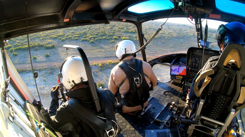
in Supplementary Information). There is one record of thermal imaging in aerial culling for pig eradication
Posted on Authorea 6 Jul 2022 — The copyright holder is the author/funder. All rights reserved. No reuse without permission. — https://doi.org/10.22541/au.165633745.51007622/v2 — This a preprint and has not been peer reviewed. Data may be preliminary.
at Hawaii Volcanoes National Park (Katahira et al. 1993), although there is no detail on how it was used.
Smaller, hand-held imagers have been used recently in helicopter-based shooting in New Zealand since 2015,
the first known use of this technology for aerial culling. Thermal-assisted aerial culling, or TAAC, programs
focused on the removal of introduced goats, deer, and pigs. The TAAC methodology has been used to remove
pigs from Falla Peninsula on Auckland Island (Cox 2019), red deer from Five Fingers Peninsula on Resolution
Island (McDonald 2017) and goats from Raukumara Ranges (D. Paine 2022, personal observation, 28 May).
While using any thermal equipment (e.g. scopes for rifles, or thermal monocular/binoculars) in aircraft could
be classified as ‘thermal-assisted’, TAAC refers to applying a specific crew configuration (a pilot, a shooter
who sits opposite the pilot and a thermal imager operator who sits behind the shooter) in conjunction with
thermal equipment.
Data The TAAC crew configuration has the potential to improve not only the detection of animal sin many
habitat types, but also enable following animals during pursuit, thereby reducing the likelihood of losing
targets. More efficient tracking could also improve animal welfare by reducing the probability that animals
are shot/wounded and then lost in thick vegetation before death is confirmed. Data collected from the
thermal imagery can measure six aspects of the approach to infer the duration and intensity of suffering:
(i ) time between first and last shot, (ii ) time from first impact shot to death, (iii ) time from start of the
pursuit until first impact shot, (iv ) time from start of the pursuit until last shot, (v ) total number of shots
taken, and (vi ) total number of shots that hit.
There has been no formal description or evaluation of the TAAC method, despite its successful long-term
application in New Zealand. We present data on the first TAAC programs undertaken in Australia to
describe the efficacy of the method for two vertebrate pest species: feral pigs and fallow deer. We measured
several aspects of the approach to test the following hypotheses: (i ) the number of shots taken and shots
impacting an animal do not vary relative to vegetation-density category (open, sparse, dense) or species
(pig, deer), (ii ) four temporal welfare indicators (time from start of pursuit to first bullet impact, time from
first bullet impact to death, time from first shot to death, time from pursuit to death) do not vary among
vegetation-density categories and species, (iii ) helicopter altitude does not vary as pursuit progresses (from
first seen, to pursuit started, to first shot, to first impact shot, to last shot), and (iv ) no animals shot are
lost. We also discuss the impact of crew configuration on target acquisition and tracking, summarise crew
feedback on the program, discuss limitations of the method, and provide recommendations for its effective
implementation.
Materials and Methods
Location and target species
We did two TAAC programs in South Australia (Fig. 1) during 2021: feral pigs on Kangaroo Island (18-30
March) and fallow deer near Kingston on the Limestone Coast (27-29 September).
Kangaroo Island (Karta Pintingga) is Australia’s third-largest island, 112 km south of Adelaide, South
Australia (Fig. 1). Over one third of the island is protected in nature reserves. Decades of intense feral
animal control has seen both deer and goats eradicated (Masters et al, 2018). Eradication efforts are now
focused on feral pigs and cats (Felis catus ) (Natural Resources Kangaroo Island, 2015). The TAAC program
consisted of 36 flying hours over the western part of the Island in previously identified areas of high pig activity
(Page et al. 2021).
Feral deer occur throughout the Limestone Coast region with fallow deer the most common (detailed site
descriptions in Supporting Information 1). The TAAC program had a total of 15.5 flying hours across
bushland on seven private holdings covering 173.7 km2 .
3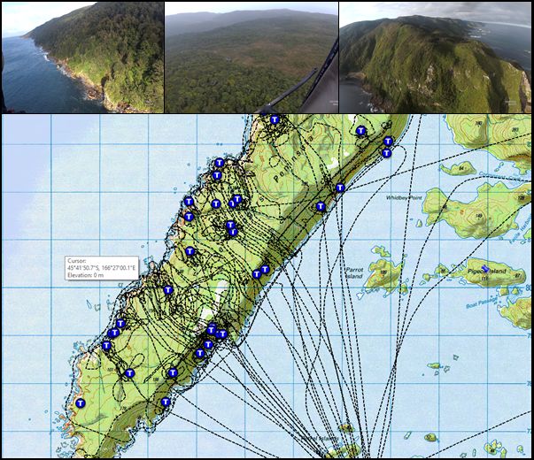
Posted on Authorea 6 Jul 2022 — The copyright holder is the author/funder. All rights reserved. No reuse without permission. — https://doi.org/10.22541/au.165633745.51007622/v2 — This a preprint and has not been peer reviewed. Data may be preliminary.

                                                                                                                                                                                                                                                              Figure 1: The location of the two thermal-assisted aerial culling programs undertaken in South Australia;
                                                                                                                                                                                                                                                              pigs on Kangaroo Island, and fallow deer near Kingston, in the Limestone Coast region.
                                                                                                                                                                                                                                                              Thermal-assisted aerial culling
                                                                                                                                                                                                                                                              Thermal-assisted aerial culling flights are done in the 2 hours from first light and 1.5 hours before last light
                                                                                                                                                                                                                                                              each day, weather permitting, when there is the greatest difference in thermal radiation between animals and
                                                                                                                                                                                                                                                              their surrounding environments (ΔT). When weather is suitable (cool and overcast with high cloud) flights
                                                                                                                                                                                                                                                              can continue throughout the day. Low-level night-time operations such as shooting are not permitted by the
                                                                                                                                                                                                                                                              Australian or New Zealand civil aviation authorities.
                                                                                                                                                                                                                                                              During a flight, both the shooter and thermal operator sit on the floor and are tethered to the helicopter
                                                                                                                                                                                                                                                              using approved aviation quick-release harnesses (Fig. 3). The tether was as short as possible, yet long enough
                                                                                                                                                                                                                                                              to allow the crew member to lean over to see the ground beneath the helicopter. We set the thermal imager
                                                                                                                                                                                                                                                              to output ‘white-hot’ greyscale imagery. Several false colour options are available on the Vayu HD; however,
                                                                                                                                                                                                                                                              the operators preferred white-hot greyscale output.
                                                                                                                                                                                                                                                              The aircraft was optimally positioned at approximately 50-100 m above ground level (AGL) and flew at
                                                                                                                                                                                                                                                              15-25 knots ground speed. The helicopter searched the area using a pseudosystematic search pattern: the
                                                                                                                                                                                                                                                              area was flown in parallel transects allowing for thorough coverage and the helicopter deviated from the

                                                                                                                                                                                                                                                                                                                     4
search pattern to pursue target animals. During the flight the thermal operator systematically scanned the
Posted on Authorea 6 Jul 2022 — The copyright holder is the author/funder. All rights reserved. No reuse without permission. — https://doi.org/10.22541/au.165633745.51007622/v2 — This a preprint and has not been peer reviewed. Data may be preliminary.
environment for heat signatures, sweeping left and right over a swath from below to approximately 400m
from the aircraft. When a potential target was detected, the thermal operator verbally alerted the shooter
and pilot, providing information on the suspected species and its general direction/location. This allowed
the shooter to focus on the area of interest, and for the pilot to begin maneuvering the aircraft towards the
target. When the target animal was approached, the thermal operator provided further detail to the pilot
in terms of the direction of movement required (e.g., nose left, fly back etc.) including safety information
such as nearby obstacles and terrain, speed of approach (e.g., go steady, stop, faster etc) where the target
animal(s) was/were and their direction of travel (e.g., “at your 9 o’clock 300m, moving left to right”) and
the number of individuals in the group. The thermal operator also identified the target’s location to the
shooter and pilot by switching on the laser pointer (Fig. 2).
Figure 2: A target animal hiding under dense vegetation in New Zealand seen by the thermal operator
(inset) and located for the shooter with a laser (blue).
Once the shooter had acquired the target and confirmed the species, both the shooter and the thermal
operator directed the pilot to position the aircraft for shooting. The slow and high approach reduced the
chances of animals scattering and losing targets.
Helicopters
For TAAC operations, the helicopter(s) must have enough power to operate safely within the target environ-
ment while carrying three people and their associated equipment. This generally requires a turbine rather
than a piston engine. The aircraft also needs to operate with the doors off or open and should not have fixed
dual controls because the shooter must be in the seat opposite the pilot For this configuration, all flights in
Australia were done with an AS350 B3 Écureuil (Squirrel) helicopter (Aérospatiale, France).
Crew configuration
The most common crew configuration for visual aerial culling in Australia and New Zealand has two people.
In New Zealand the shooter sits beside the pilot. In Australia, the shooter is either beside or behind the pilot.
In one Australian jurisdiction, a third person (safety observer - to look for wires and other obstructions) sits
beside the pilot (Fig. 3a, b). The latter observer can also collect shot-animal numbers and locations. The
TAAC approach adds a thermal camera operator behind the shooter, positioning the the thermal operator
and shooter on the same side of the helicopter to maximise communication and target acquisition/tracking
between them (Figs. 3c, 4).
5
Posted on Authorea 6 Jul 2022 — The copyright holder is the author/funder. All rights reserved. No reuse without permission. — https://doi.org/10.22541/au.165633745.51007622/v2 — This a preprint and has not been peer reviewed. Data may be preliminary.

                                                                                                                                                                                                                                                              Figure 3: Crew configurations in an AS350 B3 Squirrel helicopter for a) a visual aerial cull where the
                                                                                                                                                                                                                                                              shooter sits beside the pilot, b) a visual aerial cull where the shooter sits behind the pilot. An observer is
                                                                                                                                                                                                                                                              required in some Australian jurisdictions, and c) a thermal-assisted aerial cull where the shooter sits beside
                                                                                                                                                                                                                                                              the pilot and the thermal operator sits behind the shooter.

                                                                                                                                                                                                                                                              Figure 4: Crew configuration of thermal-assisted aerial culling in an AS350 B3 Squirrel helicopter. The
                                                                                                                                                                                                                                                              pilot is in the front right, shooter in the front left, and thermal operator in the rear left.
                                                                                                                                                                                                                                                              Crew feedback
                                                                                                                                                                                                                                                              Following the completion of the flying the crew were debriefed and provided feedback on crew configuration,
                                                                                                                                                                                                                                                              using thermal equipment, and how the program compared to any previous visual aerial culling (documented
                                                                                                                                                                                                                                                              in Supporting Information 1).
                                                                                                                                                                                                                                                              Firearms, ammunition and program costs
                                                                                                                                                                                                                                                              Details on the firearms and ammunition used in the two programs in Australia, as well as the per hour
                                                                                                                                                                                                                                                              costs associated with each program are available in Supporting Information 1. A full discussion on firearm
                                                                                                                                                                                                                                                              development for use in TAAC in New Zealand is provided in Supporting Information 2.
                                                                                                                                                                                                                                                              Imaging equipment
                                                                                                                                                                                                                                                              In both Australia and New Zealand, the Sierra-Olympic Vayu HD uncooled microbolometer array has been
                                                                                                                                                                                                                                                              used in TAAC programs. This imager has a 24 × 14.5 mm sensor that produces a 1920 × 1200 pixel

                                                                                                                                                                                                                                                                                                                    6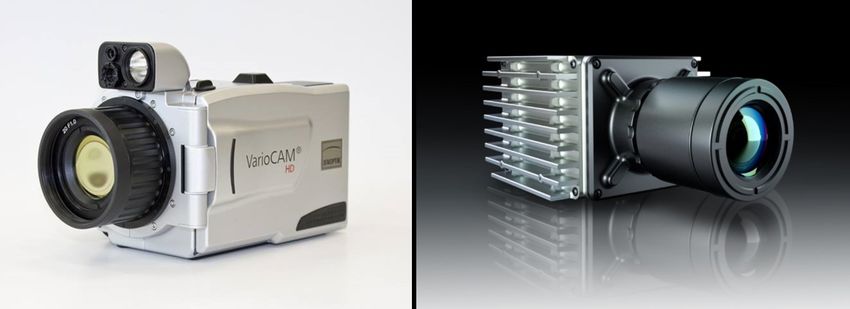
image and has a refresh rate of either > 30 (Generation 1, New Zealnd) or 60 Hz (Generation 2, Australia).
Posted on Authorea 6 Jul 2022 — The copyright holder is the author/funder. All rights reserved. No reuse without permission. — https://doi.org/10.22541/au.165633745.51007622/v2 — This a preprint and has not been peer reviewed. Data may be preliminary.
We viewed output from the thermal imager on a Blackmagic Video Assist 7” 12G HDR monitor (black-
magicdesign.com/au/products/blackmagicvideoassist) and recorded video onto SD cards for later review. A
Panasonic GH5 4K video camera was also mounted to the top of the thermal imager to collect comparative
visual footage of animal detections. The imager and monitor were mounted to a custom-built frame which
was then suspended using an Easyrig Minimax camera mount (easyrig.se) worn by the thermal operator.
A 12V, 1W, 520 nm focusable laser (Oxlasers, Shanghai, China) was mounted to the top of the thermal
imager and calibrated to point to the centre of the image. The thermal operator used the laser to visually
identify the location of detected animals to the shooter (Fig. 4). The shooter was also equipped with thermal
imaging equipment, with a thermal scope (either clip on or interchangeable with the visual scope). Shooters
also carried handheld thermal binoculars or a monocular to assist with searching and species identification.
Data and analysis
We recorded each flight with the Blackmagic Video Assist (thermal), a Panasonic GH5 4K video camera
and a GoPro 3 camera mounted to the rear firewall of the helicopter. Both the Blackmagic and the GoPro
recorded the flight audio; we used the GoPro audio when the audio on the Blackmagic recording was unclear
or did not record. Where no audio recording was usable, we excluded data from those animals from analysis.
Experienced personnel (with > 50 hours experience logging thermal-imaging surveys) reviewed and logged
the thermal footage. Two experienced personnel reviewed footage for both pigs and deer to reduce any bias
and to ensure accuracy.
We transcribed all footage in Excel® (Microsoft Corporation, 2022), including (i ) group size, (ii ) time
animal(s) were first detected, (iii ) time pursued, (iv ) habitat type where detected (dense = tree or shrub
canopy with no ground visible, sparse = tree or shrub canopy with ground visible, open = no tree or shrub
canopy), (v ) time of first-last shots taken, (vi ) which/how many shots hit animals, and (vii ) number of
impact shots until death was confirmed. Where the footage did not show the impact shots, we excluded these
data from analysis. We only considered ‘detected’ those animals that could be seen on the thermal footage.
Some animals were seen visually; however, we could not verify the number of animals because there was no
associated thermal recording of those observations.
Above ground level (AGL) (m) information was generated using the tracklog data from the flight recorded
using OruxMaps GP (oruxmaps.com) installed on a Samsung Galaxy Tab S6 Lite tablet (tablet GPS accuracy
is unknown; however, we expect ± 4.9 m for a GPS-enabled smart device) (US Space Force 2022). The
tracklog included above mean sea level altitude but not AGL. We exported the tracklog to a Keyhole
Markup Language file that we processed with a custom-built Python application SPLAT (Swath Painting
and Log Analysis Tool). SPLAT used a 30 m resolution digital elevation model downloaded from Global
Mapper (Blue Marble Geographics 2022) to calculate the aircraft AGL height for each tracklog point. We
used the tracklogs to calculate the distance travelled between each of the datapoints (time seen, time of
pursuit, time to first shot, time to first impact shot, time to last shot) to obtain distance travelled during
each stage of the event sequences. OruxMaps does not record a datum if the distance travelled was < 20m,
so any zero distances generated by SPLAT are < 20 m.
We constructed a series of general and generalised linear models using the glm function in the stats R
library (R Core Team 2021) to test for the relative effects of habitat type (open, sparse, dense [vegetation])
and species (pig or deer) on the shots (number of shots taken; number of impact shots). For the shots
dataset, we applied a Poisson error distribution and a loglink function, and log10- transformed the time data
with a Gaussian error distribution. For the AGL dataset, we constructed another set of models testing the
effects of period (seen, pursuit, first, impacted, last) with a log10 transform of altitude and a Gaussian
error distribution. For each variable we contrasted five models, including the two additive main effects, their
interaction, single effects, and the intercept-only model. We compared the relative probability of the five
models per response variable using Akaike’s information criterion corrected for small sample size (AICc )
(Burnham & Anderson 2002). The bias-corrected relative weight of evidence for each model, given the data
and the suite of candidate models considered, was the AICc weight (the smaller the weight, the lower its
7
contribution to parameter estimates) (Burnham and Anderson 2002). We also calculated the percent deviance
Posted on Authorea 6 Jul 2022 — The copyright holder is the author/funder. All rights reserved. No reuse without permission. — https://doi.org/10.22541/au.165633745.51007622/v2 — This a preprint and has not been peer reviewed. Data may be preliminary.
explained (%DE) as a measure of goodness of fit. For the habitat models, there was a single entry in the
‘open’ category for pigs, so we removed that category from all analyses.
Results
On kangaroo Island, 138 pigs were detected, and 122 were culled. On the Limestone coast, 246 deer were
detected, and 188 were culled. Sixteen pigs and 55 deer escaped as either seen and lost (pigs = 13, deer =
41), not pursued due to the pursuit of other animals (pigs = 1, deer = 14), or due to poor light conditions
(pigs = 2) (discussion on the number of lost animals in Supporting Information). Three deer moved beyond
the shoot boundary and their pursuit was abandoned. Mean group size was similar for both species (pigs =
2, largest group size = 6; deer = 2, largest group size = 8), and many single individuals of both species were
pursued. Seventy-two percent (pigs) and 53% (deer) were first detected in dense canopy/tall forest habitats.
For pigs only, 99% of the detections were made using thermal. There is no estimate for deer due to so many
other deer being flushed by pursued groups, and many individuals having to be reacquired due to scattering.
There were insufficient data (audio and thermal video) to determine accurate and detailed shooting data for
23 pigs and 8 deer. For the remaining 99 pigs and 180 deer, animals were shot an average of 3 (SD = 1.3)
and 2.2 (SD = 1.2) times each respectively (Fig. 5). Fifteen pigs and 13 deer were confirmed killed after a
single shot. From the time of detection, 95 pigs and 178 deer were first shot at within 5 min (pigs = 80.7
s, SD = 53.9; deer = 59.4 s, SD = 41.7) (Fig. 6). For the remaining 4 pigs, two were pursued and shot at
in < 10 minutes (6 min 50 s and 9 min 23 s), one took 11 min 54 s and one female took 24 min 19 s. That
female remained obscured and stationary under dense low shrub for most of the time. The remaining 2 deer
were pursued and shot at 5 min 34 s and 8 min 34 s. Average heights and times of shooting events were
comparable across both species (Table 1, Figs. 6, 7).
Table 1: Average heights and durations of shooting events for pigs and deer during thermal-assisted aerial
culling. avg = average, s = seconds, min = minutes, m = meters).
Pigs Pigs Deer Deer
Event avg SD avg SD
Detection height (m above ground level) 62.6 18.8 82.8 28.6
First impact height (m) 22.2 8.8 17.4 16.2
First shot to first impact shot (s) 10.6 27.5 23.4 30.1
First impact shot number 2 1.7 3 2.5
Time between first and last shots (s) 34.7 52.6 45.2 43.5
Time from first impact shot to death (s) 24.2 42.7 21.9 33.2
Pursuit time to death (min) 2.4 3 1.8 1.2
Distance of helicopter travel from point of detection to confirmed death (m) 658.1 1441.0 1011.8 872.5
8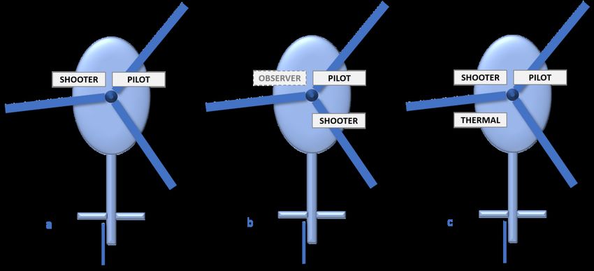
Posted on Authorea 6 Jul 2022 — The copyright holder is the author/funder. All rights reserved. No reuse without permission. — https://doi.org/10.22541/au.165633745.51007622/v2 — This a preprint and has not been peer reviewed. Data may be preliminary.
Figure 5 . Number of shots across three habitat types: OPEN, SPARSE, DENSE (vegetation). (a) total
number of shots taken; (b) total number of shots that impacted the animal.
There was only weak evidence (% deviance explained [?] 7.5%) for a difference in the total number of shots
taken and total number of impacting shots among habitat types (Table 2). For the former, the effect was
driven mainly by habitat type, and for the latter there were approximately equal contributions of habitat
type and species (Table 2).
Table 2 . Subset of the generalised linear models to test for the effects of habitat (H) type (open, sparse,
dense [vegetation]) and species (S) (pigs or deer) on the total number of shots taken and the number of shots
impacting the animal. k = number of model parameters; ? = -log likelihood; AICc = Akaike’s information
criterion corrected for small sample size; wAICc = model probability; %DE = percent deviance explained.
model k ? AICc w AICc %DE
total shots
˜ H+S 4 -713.264 1434.673 0.729 5.0
˜ H+S+H*S 6 -712.261 1436.830 0.248 5.4
˜H 3 -717.758 1441.603 0.023 3.4
shots impacted
˜ H+S 4 -450.122 908.390 0.775 7.1
˜ H+S+H*S 6 -449.733 911.774 0.143 7.5
9Posted on Authorea 6 Jul 2022 — The copyright holder is the author/funder. All rights reserved. No reuse without permission. — https://doi.org/10.22541/au.165633745.51007622/v2 — This a preprint and has not been peer reviewed. Data may be preliminary.
Figure 6 . Interval times (in seconds) across three habitat types: OPEN, SPARSE, DENSE (vegetation).
(a) time from start of pursuit to first bullet impact; (b) time from first bullet impact to death; (c) time from
first shot to death; (d) time from pursuit to death.
The evidence for an effect of habitat type and species on the time intervals shown in Fig. 6 varied depending
on the interval used as the response variable. There was no evidence for any effect on the time between
pursuit and impact, but a moderate effect of both habitat and species on the time between being shot
and death (driven mainly by differences between the two species) (Table 3). The two remaining response
variables (time between impact and death; time between pursuit and death) had comparatively weak effects
of both variables, with approximately equal contributions of both for the former, and habitat type for the
latter (Table 2).
There was a strong effect of period indicated by the general linear models for the AGL response variable,
but a comparatively weak difference between the two species (Table 3); in other words, the two species
demonstrated approximately similar trends across periods (Fig. 7 and Table 3).
Table 3 . Subset of the generalised linear models to test for the effects of habitat (H) type (open, sparse,
dense [vegetation]) and species (S) (pigs or deer) on the time intervals between pursuit and impact, impact
and death, shot and death, and pursuit and death.k = number of model parameters; ? = -log likelihood;
AICc = Akaike’s information criterion corrected for small sample size; w AICc = model probability; %DE
= percent deviance explained.
model k ? AICc w AICc %DE
pursuit–impact
˜1 1 -49.120 102.302 0.302 –
˜S 2 -48.221 102.564 0.264 1.0
impact–death
˜ H+S 4 -137.623 285.556 0.540 7.1
˜ H+S+H*S 6 -136.049 286.681 0.308 8.5
shot–death
˜ H+S 4 -134.511 279.331 0.679 16.1
˜ H+S+H*S 6 -133.272 281.128 0.276 17.1
˜S 2 -139.314 284.750 0.045 11.9
pursuit–death
˜H 3 -11.516 31.237 0.543 3.2
10model k ? AICc w AICc %DE
Posted on Authorea 6 Jul 2022 — The copyright holder is the author/funder. All rights reserved. No reuse without permission. — https://doi.org/10.22541/au.165633745.51007622/v2 — This a preprint and has not been peer reviewed. Data may be preliminary.
˜ H+S 4 -11.515 33.339 0.190 3.2
Figure 7 . Above ground-level (AGL) of the helicopter for each individual (pigs or deer) shot at each stage
of the shoot. SEEN = AGL when first spotted; PURSUIT = AGL when pursuit began; FIRST = AGL of
when first shot taken; IMPACT = AGL when first bullet impacted animal; LAST = AGL at last shot taken.
Table 3 . Subset of the generalised linear models to test for the effects of period (P) (seen, pursuit,
first, impact, last) and species (S) (pigs or deer) on the altitude above ground level. k = number of model
parameters; ? = -log likelihood; AICc = Akaike’s information criterion corrected for small sample size; w
AICc = model probability; %DE = percent deviance explained.
model k ? AICc w AICc %DE
˜ P+S+P*S 10 161.207 -300.223 > 0.999 62.9
˜ S+P 6 119.879 -225.678 < 0.001 60.7
˜P 5 115.271 -218.482 < 0.001 60.4
Discussion
Our results confirm that thermal imaging can be used to detect pest animals during aerial culling in difficult
habitat and that positioning the thermal operator and the shooter on the same side maximizes the opportu-
nity for target detection and dispatch, while considerably reducing the chances of targets being lost. Using
thermal in the TAAC configuration can therefore increase the efficacy of aerial culling programs aiming to
remove low-density pest animal populations and increase the success of eradication programs. Not being
able to detect animals reduces the probability of eradication success, particularly as terrain becomes more
rugged (Gregory et al. 2014). While neither Kangaroo Island nor the Limestone Coast are especially rugged,
the eradication of deer from Five Finger Peninsula on Restoration Island, New Zealand, highlights how the
approach can minimize the loss of efficiency caused by rugged terrain.
Using thermal imaging can aid in detecting otherwise cryptic individuals, such as those occupying heavy
cover and difficult terrain, or evading aircraft from previous experience (e.g., Saunders and Bryant 1988,
Bayne et al. 2000, Tracey and Fleming 2007; Campbell et al . 2010, Latham et al . 2018, but see Choquenot
111995). Helicopter crews can miss up to 50% of goats during visual aerial culling (Bayneet al. 2000) and
Posted on Authorea 6 Jul 2022 — The copyright holder is the author/funder. All rights reserved. No reuse without permission. — https://doi.org/10.22541/au.165633745.51007622/v2 — This a preprint and has not been peer reviewed. Data may be preliminary.
28% more pigs were found with a thermal imager than visually in a recent study (unpublished data for
Hay Plains, New South Wales, T.E. Cox). This population had experienced previous shooting, and many
animals fled to and hid in vegetation. The difference between visual and thermal detection was even more
pronounced for pigs on Kangaroo Island in this study (99% of pigs detected with thermal).
Our data suggest that animal welfare outcomes in a TAAC program are better. Only 9% of detected pigs
and 16% of deer were lost. This is considerably fewer than for visually targeted deer where 24-31% were
lost (Hampton, Bengsen et al. 2021). Our data shows that every bullet-struck animal was confirmed killed,
and no injured animals were lost. Injured and lost individuals were reported during a welfare assessment
of visual aerial culling programs for deer (Hampton, Bengsen et al. 2021). The metrics we report for deer
indicated a similar number of average impact shots (2.2, SD = 1.2) compared to 1.43-2.57 for the visual-only
program (Hampton, Bengsen et al. 2021), similar average pursuit times (59.4 s, SD = 41.7 versus 73-145 s
respectively), similar total times (108 s, SD = 72 versus 109-162 s respectively), but slightly longer times
from first shot to last shot (45.2 s, SD = 43.5 versus 17-37 s respectively). The difference arises because the
thermal-assisted approach specifically targets densely vegetated areas (particularly during the deer program),
rather than the more open areas that are typically targeted during visual aerial culling. Welfare assessments
for visual helicopter-based aerial culling have not been done for pigs, but the number of impact shots per pig
in a visual aerial culling study assessing ammunition were similar (3, SD = 1.3 versus 2.98-3.29) (Hampton,
Eccles et al. 2021). Shooters involved in the TAAC programs also indicated improved welfare outcomes (see
Supporting Information) and the TAAC crew configuration appears to be an integral part of the improved
welfare outcomes.
Several crew configurations have been trialed for thermal-assisted culling in New Zealand (documented in
Supporting Information 1 and 2), and while thermal imaging invariably increases detections regardless of
equipment placement, operators indicated that the greatest benefit came from positioning the shooter and
the operator on the same side (D. Paine 2021, personal observation, 16 June). In a recent study where the
thermal operator and the shooter were both positioned in the rear of the helicopter on opposite sides, 14%
of animals found with thermal were lost after transitioning to the shooters side of the aircraft. The shooter
in this study had no thermal equipment. The time from detection to first shot was also longer for animals
found with thermal than with visual due to the requirement to reposition the aircraft (unpublished data for
Hay Plains, New South Wales, T.E. Cox). Having the shooter in the front, and opposite the pilot, gives the
shooter the widest field of view and the best opportunity for verbal and body-language communication with
the pilot. Having the operator behind the shooter provides essential support to the shooter to find new and
escaping targets, to confirm species identification and confirm successful destruction of the animal (D. Paine
2022, personal observation, 18 May).
When and how to use thermal-assisted aerial culling
The TAAC configuration can be particularly useful when detection probability is low due to dense vegetation,
avoidance behavior, or low density. Thermal imaging is a tool that can provide a high level of confidence in
aerial culling programs, especially those that are focused on eradication.
We make several recommendations for any jurisdiction considering thermal-assisted aerial culling. The
selection of thermal sensor is important (see Cox et al. 2021); and a high-resolution imager with a minimum
of 30 Hz viewing rate is essential. A large sensor size increases swath width and depth, allowing for more
area to be surveyed quickly. Transitioning to thermal imagery will be more productive if the shooter has
experience with the thermal equipment in ground-shooting operations. Given the extent of communication
between crew in a thermal-assisted program, and particularly between the thermal operator and the pilot,
who are on diagonally opposite sides of the helicopter, clear terminology and standard phraseology should be
established prior to any program to avoid confusion (this approach would also be beneficial for visual aerial
shooting programs). Team communication evolves most efficiently when confronted with a real shooting
situation. This enables the crew to learn how to work with each other and to work out their strategies.
During searches themselves, the two observers equipped with thermal imaging (operator and shooter) can
12identify animals quickly, permitting a high and steady approach (e.g., 90 m and 30-40 knots) that provides
Posted on Authorea 6 Jul 2022 — The copyright holder is the author/funder. All rights reserved. No reuse without permission. — https://doi.org/10.22541/au.165633745.51007622/v2 — This a preprint and has not been peer reviewed. Data may be preliminary.
more opportunities for an effective engagement (B. Florence, 2021, personal observation, 22 July).
Limitations
Animal detections using thermal are maximized when ΔT (difference in thermal radiation between the
animal and its surroundings) is greatest. This usually occurs when the ground and vegetation is at its coldest
point, or in the first 1.5-2 hours after first light, and/or before shadows from solar radiation appear on the
ground. Solar insolation has the greatest impact on increasing the thermal radiation of the environment and
considerably reducing ΔT; and after consistent insolation, ΔT can become negative making animals difficult
or impossible to detect against the background. This typically occurs 1.5-2hrous after daybreak in cloudless
conditions on flat terrain. Therefore, the amount of effective thermal operational hours is limited.
During winter, conditions might also be suitable for thermal in the afternoon in the last 1.5 hours before
last light. Therefore, TAAC programs are usually limited to the cooler months of the year to maximize the
number of effective thermal hours available. Additionally, while overcast conditions can extend the duration
of a TAAC program each day; fog, rainfall or high winds negatively affect thermal imager performance.
Crew performance can also be negatively affected and should be monitored for signs of fatigue and reduced
performance.
Finally, vegetation type and condition can impact thermal imager performance and therefore the detection
and identification of target animals. Epicormic growth in bushfire affected plants, wet leaves (after moist
conditions overnight), and certain types of low and dense shrubs (e.g. coastal heath) can all erode efficiency.
Conclusion
Thermal imaging technology increases the detection of animals in aerial culling programs. The TAAC crew
configuration maximises target acquisition opportunity, and results in no loss of injured animals, thereby
improving the animal welfare outcomes normally associated with aerial culling programs. The ability to
detect animals in difficult habitat, that are at low densities or that exhibit avoidance behaviour, coupled
with the ability of the thermal operator to track and monitor additional members of a group will improve
the success of control and eradication programs and ensure the best possible animal welfare outcomes.
Acknowledgements
We acknowledge Grant Halverson (Vale), David Paine and Norman McDonald who pioneered the TAAC
methodology in Raukumara, Bay of Plenty, New Zealand. This study was made possible with the partic-
ipation of Kangaroo Island National Parks and Wildlife Service and Kiland Ltd (Formerly KI Plantation
Timbers) and a number of private landholders on the Limestone Coast. We thank Chad Wilsdon, Tyronne
Fitzgerald and Warren White for collecting the data during the aerial operations on the Limestone Coast,
as well as Sebastien Comte for providing comments on this manuscript. The work on Kangaroo Island was
jointly funded through State and Commonwealth Government Disaster Recovery Arrangements. The work
on the Limestone Coast was funded through the National Feral Deer Coordinator Project (a Centre for
Invasive Species Solutions project, funded by the Australian Government). All aerial culling was completed
as part of ongoing pest animal management operations which do not require animal ethics approval. The
authors declare no conflict of interest.
Authors contribution statement
DP, MT, AW, MK, RM and BP conceived the ideas, DP, MT, AW, MK, RM, BF, KF, TB and BP designed
methodology, MT, AW, MK, RM, BF, KF, TB, RM, TEC, EOH and BP collected the data, TB, TEC, EOH
and CJAB analysed the data, TEC led the writing of the manuscript and all authors contributed critically
to the drafts and gave final approval for publication.
Data Availability Statement
13The data used in the analysis will be available from the Dryad Digital Repository. The original thermal
Posted on Authorea 6 Jul 2022 — The copyright holder is the author/funder. All rights reserved. No reuse without permission. — https://doi.org/10.22541/au.165633745.51007622/v2 — This a preprint and has not been peer reviewed. Data may be preliminary.
footage is the property of The Department of Primary Industries and Regions South Australia.
References
Bayne P, Harden B, Pines K and Taylor U (2000) Controlling feral goats by shooting from a he-
licopter with and without the assistance of ground-based spotters. Wildlife Research 27: 517-523
doi.org/10.1071/WR99059
Bengsen AJ, Forsyth DM, Pople A, Brennan M, Amos M, Leeson M, Cox TE, Gray B, Orgill O, Hampton
JO, Crittle T and Haebich K (2022) Effectiveness and costs of helicopter-based shooting of deerWildlife
Research (accepted 14 April 2022)
Bennett M. (1979) ‘The Venison Hunters’ (A.H. & A.W. Reed: Wellington)
Blue Marble Geographics (2022) Global Mapper www.bluemarblegeo.com/
Bomford M and O’Brien P (1995) Eradication or control for vertebrate pests? Wildlife Society Bulletin
23(2):249-255 www.jstor.org/stable/3782799
Boonstra R, Krebs C J, Boutin S and Eadie JM (1994) Finding Mammals Using Far-Infrared Thermal
Imaging Journal of Mammalogy 75(4): 1063-1068 doi.org/10.2307/1382490
Burnham KP and Anderson DR (2002) ‘Model selection and multimodel inference: a practical information-
theoretic approach’ New York, USA: Springer-Verlag
Campbell TA, Long DB, and Leland BR (2010) Feral swine behaviour relative to aerial gunning in southern
Texas Journal of Wildlife Management 74: 337–341
Challies CN (1977) Effects of commercial hunting on red deer densities in the Arawata Valley, South West-
land, 1972–76 New Zealand Journal of Forestry Science 7:263–273
Corcoran E, Denman S, Hanger J, Wilson B and Hamilton G (2019) Automated detection of koalas using low-
level aerial surveillance and machine learning Scientific Reports 9: 3208 doi.org/10.1038/s4159 8-019-39917
-5
Cox F (2019) Maukahuka Pest Free Auckland Island: Out-come zero pigs. Department of Conser-
vation, New Zealand www.doc.govt.nz/globalassets/documents/our-work/maukahuka-project/maukahuka-
pigs-info-sheet.pdf accessed 12 May 2022
Cox TE, Matthews R, Halverson G and Morris S. 2021. Hot stuff in the bushes: Thermal imagers and the
detection of burrows in vegetated sitesEcology and Evolution 11(11): 6406-6414 doi.org/10.1002/ece3.7491
Croon, GW, McCullough DR, Olson CE and Queal LE (1968) Infrared scanning techniques for big game
censusing Journal of Wildlife Management32: 751-759 doi.org/10.2307/3799549
Forsyth DM, Thomson C, Hartley L, MacKenzie DI, Price R, Wright EF, Mortimer J, Nugent G, Wil-
son L and Livingstone P (2011) Long-term changes in the relative abundances of introduced deer in
New Zealand estimated from faecal pellet frequencies New Zealand Journal of Zoology 38: 237–249
doi.org/10.1080/03014223.2011.592200
Forsyth DM, Ramsey DSL, Veltman CJ, Allen RB, Allen WJ, Barker RJ, Jacobson CL, Nicol SJ, Richardson
SJ and Todd CR (2013) When deer must die: large uncertainty surrounds changes in deer abundance achieved
by helicopter- and ground-based hunting in New Zealand forestsWildlife Research 40: 447–458
Gregory SD, Henderson W, Smee E, and Cassey P (2014) Eradications of vertebrate pests in
Australia: A review and guidelines for future best practice . PestSmart Toolkit publication,
Invasive Animals Cooperative Research Centre, Canberra, Australia
14Hampton JO, Bengsen AJ, Pople A, Brennan M, Leeson M, Forsyth DM (2021) Animal welfare outcomes
Posted on Authorea 6 Jul 2022 — The copyright holder is the author/funder. All rights reserved. No reuse without permission. — https://doi.org/10.22541/au.165633745.51007622/v2 — This a preprint and has not been peer reviewed. Data may be preliminary.
of helicopter-based shooting of deer in Australia Wildlife Researchdoi.org/10.1071/WR21069
Hampton JO, Eccles G, Hunt R, Bengsen AJ, Perry AL, Parker S, Miller CJ, Joslyn SK, Stokke S, Arnemo
JM and Hart Q (2021) A comparison of fragmenting lead-based and lead-free bullets for aerial shooting of
wild pigs PLoS ONE 16(3): e0247785 doi.org/10.1371/journal.pone.0247785
Hone J (1990) Predator-prey theory and feral pig control, with emphasis on evaluation of shooting from a
helicopter Australian Wildlife Research 17: 123–130
Husheer SW, Robertson AW (2005) High-intensity deer culling increases growth of mountain beech seedlings
in New Zealand Wildlife Research 32:273–280
Korn TJ (1986) Use of helicopters for feral pig control. In ’Proceedings of 10th National Noxious Plants and
Animals Conference’ (Ed. D Brown) pp. 45-50. (NSW Agriculture: Orange)
Katahira LK, Finnegan P and Stone CP (1993) Eradicating Feral Pigs in Montane Mesic Habitat at Hawaii
Volcanoes National Park Wildlife Society Bulletin 21(3): 269-274 www.jstor.org/stable/3782865
Latham ADM, Latham MC, Herries D, Barron M, Cruz J, and Anderson, DP (2018) Assessing the efficacy of
aerial culling of introduced wild deer in New Zealand with analytical decomposition of predation riskBiological
Invasions 20: 251–266 doi.org/10.1007/s10530-017-1531-0
Lethbridge M, Stead M and Wells C (2019) Estimating kangaroo density by aerial survey: a comparison of
thermal cameras with human observers Wildlife Research 46: 639–648 doi.org/10.1071/WR18122
Masters P, Markopoulos N, Florance B and Southgate R (2018) The eradication of fallow deer (Dama dama )
and feral goats (Capra hircus ) from Kangaroo Island, South AustraliaAustralasian Journal of Environmental
Management 25(1): 86-98
McDonald N (2017) Five Fingers Peninsula Thermal Camera Trial 2017 Part 1. Internal report DOC-5927153
Mellor DJ, and Littin KE (2004) Using science to support ethical decisions promoting humane livestock
slaughter and vertebrate pest control Animal Welfare 13: 127–132
Natural Resources Kangaroo Island (2015) ‘Feral Cat Eradication on Kangaroo Island 2015–2030’ (South
Australian Department of Environment and Water: Kingscote, SA, Australia)
NSW Department of Primary Industries (2022a) NSWPIG SOP2 Aerial shooting of feral pigs NSW PIGCOP:
Feral Pig Code of Practice and Standard Operating Procedureswww.dpi.nsw.gov.au/biosecurity/vertebrate-
pests/publications/standard-operating-procedures accessed 12 May 2022
NSW Department of Primary Industries. 2022b. NSWDEER SOP2 Aerial shooting of feral
deer. NSW DEERCOP: Feral Deer Code of Practice and Standard Operating Procedures
www.dpi.nsw.gov.au/biosecurity/vertebrate-pests/publications/standard-operating-procedures accessed 12
May 2022
Nugent G, Parkes JP and Tustin KG (1987) Changes in the density and distribution of red deer and wapiti
in northern Fiordland New Zealand Journal of Ecology 10: 11–21
Nugent G and Fraser KW (2005) Red deer. In ‘The Handbook of New Zealand Mammals’. 2nd edn. (Ed.
C. M. King.) pp. 401–420. (Oxford University Press: Melbourne)
Page B, Bradshaw CJA, Korcz M and Tarran M (2021) Eradication of pigs on Kangaroo Is-
land: updated predictions to inform the probability of eradication. Government of South Aus-
tralia pir.sa.gov.au/ data/assets/pdf file/0004/396643/Updated predictions on the program to eradicate -
feral pigs from Kangaroo Island.pdf accessed 21 May 2022
Parker HDJ and Driscoll RS (1972) An experiment in deer detection by thermal scanning Journal of Range-
land Management 25: 480-481
15Parkes J, Henzell R and Pickles G (1996) ‘Managing Vertebrate Pests: Feral Goats.’ (Australian Government
Posted on Authorea 6 Jul 2022 — The copyright holder is the author/funder. All rights reserved. No reuse without permission. — https://doi.org/10.22541/au.165633745.51007622/v2 — This a preprint and has not been peer reviewed. Data may be preliminary.
Printing Service: Canberra)
R Core Team (2020) R: A language and environment for statistical computing. R Foundation for Statistical
Computing, Vienna, Austria www.R-project.org/
Reddiex B, Forsyth DM, McDonald-Madden E, Einoder LD, Griffioen PA, Chick RR, Robley AJ (2006) Con-
trol of pest mammals for biodiversity protection in Australia. I. Patterns of control and monitoring. Wildlife
Research 33: 691-709 doi.org/10.1071/WR05102
Saunders G and Bryant H (1988) The evaluation of a feral pig eradication program during a simulated exotic
disease outbreak Australian Wildlife Research 15: 73–81 doi.org/10.1071/WR9880073
Saunders G (1993) Observations on the effectiveness of shooting feral pigs from helicopters. Wildlife Research
20: 771-776 doi.org/10.1071/WR9930771
Sharp T (2012) Aerial shooting of feral pigs. Standard Operating Procedure PIG002. PestSmart web-
site https://pestsmart.org.au/toolkit-resource/aerial-shooting-of-feral-pigs accessed 12-05-2022
Sharp T and Saunders G (2011) ‘A Model for Assessing the Relative Humaneness of Pest Animal Control
Methods.’ 2nd edn. (Australian Government Department of Agriculture, Fisheries and Forestry: Canberra,
ACT)
Spaan D, Burke C, McAree O, Aureli F, Rangel-Rivera CE, Hutschenreiter A, Longmore SN, McWhirter
PR and Wich SA (2019) Thermal infrared imaging from drones offers a major advance for spider monkey
surveysDrones 3: 34 doi:10.3390/drones3020034
Tracey J and Fleming PJS (2007) Behavioural responses of feral goats (Capra hircus ) to helicopters Applied
Animal Behaviour Science 108: 114–128
US Space Force (2022) www.gps.gov/systems/gps/performance/accuracy/ accessed 22 May 2022
Warburton B, Anderson DP and Nugent,G (2018) Economic aspects of New Zealand’s wild venison recovery
industry. In ‘Advances in Conservation through Sustainable Use of Wildlife. Proceedings of a conference
held in Brisbane, Australia, 20 August to 1 September 2016’. (Eds G. Baxter, N. Finch and P. Murray.) pp.
265–271. (Wildlife Science Unit, School of Agriculture and Food Sciences, The University of Queensland:
Gatton)
Supporting Information 1
Detailed site descriptions
Kangaroo Island
The island has a terrestrial area of 4,405 km2 and is 145 km long (E-W) × 54 km wide at its widest point
with a population of > 4000 people. In 2019/2020 > one-third of the island was severely burnt by bushfires,
reducing the feral pig population by approximately 90%. This provided an opportunity to eradicate the low-
density population while vegetation recovery enabled high detectability. After the 2019/2020 fires, the feral
pig population was estimated to be < 450 individuals (Page et al. 2021). As part of the Island’s post-bushfire
feral pig eradication program there has been extensive ground shooting (one intensive three-month period
that removed 165 pigs), trapping, and baiting for pigs across the island. Ad-hoc aerial culling occurred in
March 2020 while a helicopter was on the Island for aerial baiting. This approach resulted in three 2 h
shooting sessions and removed 7 pigs. The remaining individuals are increasingly difficult to bait or trap,
with animals restricted to the western end of the Island, and typically located in inaccessible parts of farms,
former plantation forests, as well as parks and reserves. The TAAC program was undertaken over creek lines
16of Flinders Chase National Park, The Ravine des Casoars Wilderness Protection Area (WPA), Cape Torrens
Posted on Authorea 6 Jul 2022 — The copyright holder is the author/funder. All rights reserved. No reuse without permission. — https://doi.org/10.22541/au.165633745.51007622/v2 — This a preprint and has not been peer reviewed. Data may be preliminary.
WPA, Cape Bouguer WPA, Kelly Hill CP, Western River WPA and Vivonne Bay Conservation Park.
Limestone Coast
The Limestone Coast is a low-lying region of south-eastern South Australia that consists of ancient, low sand
dunes and incorporates important Ramsar listed wetland areas such as the Coorong and Bool Lagoon. Feral
deer occur throughout the region with fallow deer the most common deer species. The TAAC program took
place across patches of bushland on seven private holdings totalling 173.7 km2 . Properties included a mix of
grazing and cropping, with areas of remnant tea-tree (Melaleuca alternifolia) and eucalypt woodland. Visual
shoots have been done in this area 1-2 times year-1 for several years. Landholders also engage contract,
volunteer and/or recreational shooters to assist with deer management and a commercial harvester also
worked across most of the seven holdings regularly between 2018–2020. A visual aerial cull was done over
the area 10 days prior (13–17 September) to the TAAC program. The visual shoot crew flew 89.9 h, using
2 helicopters over 5 days, and shot 603 deer across 128,103 ha2 , with the aim of removing as many deer
as possible as quickly as possible. While vegetated areas were included, targeting occurred mainly on open
pasture.
Estimation of program costs
We followed the guidelines in Iacona et al. (2018) for collecting and reporting intervention-level costs in 2021
Australian dollars (AUD). The following costs are indicative rates only and might vary between providers
and/or countries. They are also only for operational hours and do not include mobilisation costs such as ferry
of the helicopter to site, positioning of a fuel truck or travel costs for the crew. Where day rates were given,
we calculated the hourly rate as day rate × number of days ÷ number of hours. We calculated the hourly cost
of control as: hourly cost = helicopter hourly wet rate + shooter hourly rate + thermal operator hourly rate
+ imager hire hourly rate + (cost round-1 × animals shot hour-1 × shots animal-1 ). We used the following
rates to calculate program costs: helicopter wet rate for a AS350 B3 Squirrel = $2500 hour-1 , shooter rate
= $1200 day-1 , thermal operator rate = $650 day-1 and imager hire = $900 day-1 . We averaged ammunition
costs at $2.25 round-1 . The cost for the pig program (36 hours flown over 13 days) was $3515.93 hour-1 .
There have since been two additional thermal-assisted aerial cullings on Kangaroo Island, with a total of 394
pigs removed over the three programs. The cost for the deer program (15.5 hours flown over 3 days) was
$3092.25 hour-1 . The deer trial was stopped after 15.5 hours of shooting because the land manager felt the
trial was successful and did not require further evidence of its effectiveness.
Firearms and ammunition
Types of firearms and ammunition used in aerial culling are determined by each jurisdiction. In the Australian
programs a Springfield M1A 308 calibre self-loading rifle was used with 135 grain hollow-point ammunition
for pigs, and 150 grain soft-point ammunition for deer. In New Zealand a variety of firearms are used. The
common calibres are 223 with 55 grain soft or hollow point for goats or 64 grain for deer, 308 using 130
grain soft or hollow point for goats and 150 grain for deer, and a 12 gauge shotgun using 9 or 12 ball
“00” lead Buckshot for goats and deer. A full discussion of firearm development for TAAC can be found in
Supplementary Information 2.
Lost animals
The reported number of deer lost during the Limestone Coast case study is potentially overestimated.
When density is high, it is difficult to track all individuals in a group. During a shoot, individuals would
often leave the group or additional individuals would be acquired. Without being able to identify animals
individually, it is difficult to know if lost animals are in fact lost, or whether they are reacquired as part of
another group. For this reason, ‘lost animal’ data from the deer shoot, and likely the pig shoot, are probably
inaccurate. The deer data in this case study are for fallow deer only. Therefore, we cannot make reliable
inferences about effectiveness for other deer species. Similarly, for pigs, the number of lost animals is likely
17You can also read