THE URUGUAY RIVER A Permeable Border in South America - Environment & Society Portal
←
→
Page content transcription
If your browser does not render page correctly, please read the page content below
Review of International American Studies

                                                                                                                                       FEATURES
RIAS Vol. 14, Spring—Summer № 1 /2021
ISSN 1991—2773
DOI: https://doi.org/10.31261/rias.10047

THE URUGUAY RIVER
A Permeable Border in South America

     introduction

        The Uruguay River is an important watercourse in South                                                                          Eunice Nodari
                                                                                                                                        Federal University
     America. It begins with three minor rivers, the Pelotas, Canoas                                                                    of Santa Catarina
     and Peixe, whose sources are located in the Serra Geral highlands,                                                                 UFSC, Brazil
     around 1,800 meters above sea level (Marcuzzo 2017: 1). Today                                                                      and
                                                                                                                                        Marcos Gerhardt
     the Uruguay River serves as the international frontier between                                                                     University
     Brazil and Argentina and between Uruguay and Argentina. It also                                                                    of Passo Fundo
                                                                                                                                        UFP, Brazil
     marks the border between the Brazilian states of Santa Catarina
     (SC) and Rio Grande do Sul (RS). At the end of its approximately

                                                                                                                                        https://orcid.org/0000-0001-5953-649X
                                                                                                                                                                                https://orcid.org/0000-0003-1457-7321
     two-thousand kilometers course, it flows into La Plata River,
     a major estuary close to Buenos Aires in Argentina and Monte-
     video in Uruguay. The importance of the Uruguay River can be
     evaluated by the size of its hydrographic basin (fig. 1), formed
     by dozens of affluents, covering a total area of roughly 349,843
     square kilometers (Marcuzzo 2017: 4).

             Fig. 1. Uruguay River Basin. Source: Francisco F. N. Marcuzzo, Uruguay River drainage basin: altimetry and areas. Anais
             do XXII Simpósio Brasileiro de Recursos Hídricos, 2017.

                                                                                                                             201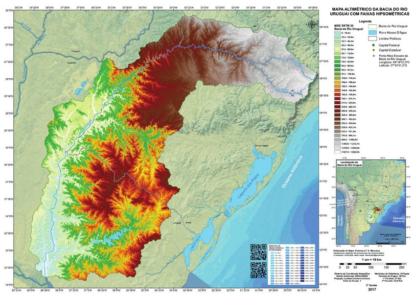
This article discusses the social, cultural, environmental and eco-
                                                   nomic importance that the Uruguay River has had for diverse
                                                   social groups living within its drainage basin from the eighteenth
                                                   century to the present, considering different forms of interaction
                                                   with the river and nearby areas. It also discusses the significance
                                                   of the Uruguay River as a permeable frontier, a place of circulation
                                                   for merchandise, people, and ideas in the border zone between
                                                   Brazil, Argentina, and Uruguay. Finally, it discusses the profound
                                                   socio-environmental transformations that took place in the Uru-
                                                   guay River basin over the nineteenth and twentieth centuries
                                                   and the attempts to preserve and restore regional environments
                                                   and landscapes linked to the river.
                                                       As research sources, the article uses travellers’ reports,
                                                   the records of employees of the Brazilian State, reports and cor-
                                                   respondence by governors, documents relating to the nature
                                                   conservation units and implanted economic exploration projects.
                                                   It interprets these sources through environmental history, which
                                                   includes human societies, but also recognizes the historicity
                                                   of natural systems, constructing “an open and interactive reading
                                                   between both” (Pádua 2010: 97).
                                                       The environmental history of Brazilian rivers has received the atten-
                                                   tion of diverse researchers, highlighting Gilmar Arruda (2008), Victor
                                                   Leonardi (1999), Haruf Espindola (2005), Eunice Sueli Nodari (2019),
                                                   Janes Jorge (2006), Marluza Harres and Fabiano Q. Rückert (2015)
                                                   and Bruno Capilé (2018), among others, who have researched human
         Rivers                                    interactions with the river and its surrounding areas.
of the Americas
            rias vol. 14, spring–summer № 1/2021

                                                   first interactions

                                                       The archaeological research showed the presence of indigenous
                                                   populations belonging to the Tupi-Guarani linguistic subfamily
                                                   in the valley of the Uruguay River from approximately two-thousand
                                                   years ago to the present. They were “horticulturists and made
                                                   their swiddens in a slash-and-burn system, also known as coivara.”
                                                   These populations settled in places “with access to rich sources
                                                   of water and dense forests, where they could reproduce their
                                                   lifestyle.” They chose fertile lands ideal for agriculture, gathered
                                                   molluscs, and fished in the rivers and lakes, and hunted animals
                                                   in the forest. Through these activities “they were able to capture
                                                   202
the necessary proteins and fats, as well as bones, hides, feathers
review of international american studies
and shells” (Ferrasso and Schmitz 2013: 128).
The accounts of voyages and letters on the apostolic works
of the European priest Anton Clemens Sepp of the Company
of Jesus provide us with important information on the Jesuit mis-
sions established in the drainage basins of the Uruguay, Paraná
and Paraguay Rivers in the seventeenth and eighteenth centuries.
On his voyage to South America in 1691, the priest Sepp described
the rivers as navigable paths to the interior of the continent and was
impressed by the abundance of fish, “none of which look like our
European varieties,” he wrote. The volume was such that “the
water tingled with so many fish.” In his Christian comprehension
of American nature, “this is caused by the fact that since creation
of the world nobody has fished here yet” (Sepp 1980: 111). Eunice Nodari
The Jesuits worked in the Christianization of the Guarani peoples Federal University
in diverse missions, among them the mission of Yapeyu, situated of Santa Catarina
UFSC, Brazil
close to the shore of the Uruguay River, “as large as the Danube and
near to Vienna” (Sepp 1980: 111). When he became ill in the interior Marcos Gerhardt
University
of Paraguay, he was sent to the São Francisco Xavier mission, close of Passo Fundo
to the right bank of the Uruguay River, where “fresher airs cooled UFP, Brazil
my lungs and ended up refreshing my organism as a whole” (197).
As well as the missions on the right bank, another seven missions
were established on the river’s left bank, some of them dozens
of kilometers from its waters. In the region of the final stretch
of the Uruguay River, further south, was inhabited by the Guenoa-
Minuane indigenous people, who had little connection to the Jesuit
missions (Bracco 2016: 44).
Although it flowed through the large region of Jesuit missions,
a long stretch of the Uruguay River was considered the southern bor-
der between the colonial domains of Spain and Portugal in the Treaty
of Madrid, signed in 1750. Indigenous resistance to this colonial
redivision of the territory generated the Guarani War from 1753
to 1759, involving Christianized Guarani and the troops of Portugal
and Spain. Divergences in the demarcation of the territories led
to the collapse of this treaty and the outbreak of other conflicts
in the south of America over the ensuing years (Golin 2015: 66).
The chronicler Hemetério Velloso da Silveira visited this region
of the missions close to the Uruguay River at the start of the twen-
203tieth century and observed that the Uruguay River continued
to be “abundant in fish. We saw surubi, gilded catfish, flounders,
stingrays, pacu, and leporinus of large sizes. Some residents
of the town, poor, live off fishing” (Silveira 1909: 388). He also
visited Uruguaiana, where he observed the steamboat trans-
portation service for passengers and cargo on the Uruguay River,
linking towns on the Brazilian shore with towns and settlements
on the Argentinean shore. As well as the steamboats, he observed
that there existed, “for the traffic of merchandise and foods
from the two countries, more than eighty foreign and national
boats like, launches, flatboats, canoes and punts” (415). When he
was in São Francisco de Borja, another Jesuit mission, he observed
the existence of the Passo de São Borja settlement, a location
where one could traverse the Uruguay River during the drier part
of the year. However, he wrote that “the high waters on the Uru-
guay, when the river overflows, flood some of Passo’s streets
and houses, producing intermittent fevers, vernacularly called
Chucho, and sometimes typhoid” (249).
the forests of the uruguay river and yerba mate harvesting
Along the upper course of the Uruguay River, in the east
of the South American continent, at altitudes over 600 metres (fig.
1), we find Mixed Ombrophilous Forest or Araucaria Forest (Araucaria
angustifolia), which dominates the region’s canopy and landscape.
Below this species grow many other trees and plants, inhabited
Rivers by a variety of fauna, making this forest an impressive example
of the Americas
of biodiversity. The indigenous populations and fauna obtained
rias vol. 14, spring–summer № 1/2021
pinhão in this forest, the edible seed of the Araucaria pine which
constitute an important food source in the region.
Following the course of the Uruguay River westward, at lower
altitudes, another kind of forest begins to appear. In the travel
report of the French merchant Nicolau Dreys, first published
in 1839, the forests of the Uruguay River, still unknown to Euro-
peans, formed one of the boundaries of the Jesuit mission territory
established on the left shore of the river (1990: 72).
In 1857 and 1858 the engineer Francisco Rave coordinated
an expedition that travelled through the northwest of the province
of Rio Grande do Sul, visited the immense forests “that spread along
204the shores of the Uruguay” and perceived the changes in the forest’s
review of international american studies
composition with the absence of Araucaria pine and the occurrence
of angico, cedar, laurel and palm species (Rave 1858).
At the end of the nineteenth century, the chronicler Evaristo
Affonso de Castro recorded the existence of this large forest
on the left-hand shore, containing abundant numbers of animals
and plants from which, in his evaluation, timber could be extracted.
Castro transcribed the report of an exploratory expedition led
and recorded by the German surveyor Maximilian Beschoren:
Filled with wonder, I contemplated these forests that line the Upper Uru-
guay, whose gigantic vegetation entrances the observer and is entirely
unaware of the potency of the human arm, raised to hurl the trees
to the ground; they are representatives of a centuries-old plant life
and moreover, are still virgin forests. (Castro 1887: 249)
Eunice Nodari
Federal University
The surveyor’s views are similar to those described by the priest of Santa Catarina
Sepp as they both believed themselves to be standing before UFSC, Brazil
and
untouched nature. Immediately, he considered the possibility Marcos Gerhardt
of felling part of the forest as a form of economic exploration. University
of Passo Fundo
Later in the same report, he would write: UFP, Brazil
Our joy was indescribable. In this place we made echo the roar of our
guns, announcing to these centuries-old forests that civilized men
found themselves there filled with jubilation at having reached the end
of their explorations and astonished by so much natural beauty, were
contemplating the grandiose spectacle that only the hand of the Creator
of the Universe could show to man in the powerful scene in which he
unveils the majestic Uruguay. If there are moments in life that a man
can never forget, this is one of them! (261)
In another work from the end of the nineteenth century,
Beschoren registers his own admiration for the “extraordinary
vegetation of the forest of the Upper Uruguay,” particularly
along the river shore, which “consists of an impenetrable tangle
of spines and vines of the most diverse species. Wising to enter
the riverside forest without a machete is a useless endeavour.
I had never encountered a forest like that, so dense!” (Beschoren
1989: 49). Another excerpt from his narrative reads as follows:
What an immense and varied vegetation confronts us! What gigantic
trees! Vines wind from one to another in multiple forms, covered by rare
205and beautiful orchids. On the ground an impenetrable tangle of ferns,
thorns, reeds, vines and fallen trees. The jungle alarms and terrifies
the invader due to the impact of the plants and inextricable chaos. (104)
The surveyor ends his book by reinforcing the idyllic image
of the valley of the Uruguay River: “In all the Province, I know
of no other place so marvellous as the valley of the Goio-En,
in Nonoai. This territory, covering hundreds of square miles,
is for the most part still virgin land, covered by woods, virgin forest,
a ground still untouched by civilized man” (Beschoren 1989: 192).
In 1893, the Swedish traveller and botanist Carl Axel Magnus
Lindman also wrote about the existence of a forest formed
by large trees associated with other levels or layers of vegetation.
This forest was constituted by species like cabreúva, inga, angico,
camboatá, sweet cotton, açoita-cavalo, canela preta, yerba mate,
laurel, guayaibi, tarumã, ipê and others (1974: 204). Yet another
chronicler, Hemetério Velloso da Silveira, wrote of the variety
of the flora and fauna existing in the territory pertaining to the Jesuit
missions, in the basin of the Uruguay River. His book, dated 1909,
contains lists of animal and plant species that inhabited the region,
testifying to the biodiversity that still marked these ecosystems
at the beginning of the twentieth century.
All these authors refer to the forest present along a stretch
of the Uruguay River Valley, covered by Temperate Deciduous
Forest, a form of vegetation belonging to the Atlantic Rainforest
Biome (Mata Atlantica), which covers around one million square
Rivers
of the Americas kilometers (Dean 1996: 24), to which the Mixed Ombrophilous
Forest also belongs.
rias vol. 14, spring–summer № 1/2021
Among these plants of the Temperate Deciduous Forest,
we can highlight yerba mate (Ilex paraguariensis), catalogued
by the French botanist Auguste de Saint-Hilaire in the nineteenth
century. The tree’s leaves and branches, dried and ground, are
used to prepare a drink highly popular in the south of the conti-
nent due to its property as a stimulant, since it contains caffeine.
Its consumption has been a cultural practice of diverse indigenous
peoples inhabiting this territory for thousands of years. Concen-
trations of this tree, forming the yerba forests, exist in portions
of the large drainage basins of the Uruguay, Jacuí, Paraná, Iguaçu
and Paraguay Rivers, which were explored economically.
206During the nineteenth century, a large poor population obtained
review of international american studies
their livelihood working in the extraction and preparation of yerba
mate from the forests, one of the main trade products originating
in South America (Gerhardt 2013; 78). Some of this yerba mate
was transported in carts or on animals to the shores of the Uru-
guay River from where it would continue, on boats, to the foreign
consumer markets of Argentina and Uruguay. Central to this trade
was the port of Itaqui, situated on the right shore of the Uruguay
River, through which thousands of tons of yerba mate were
exported (Linhares 1969: 105).
Diverse travellers, government employees and chroniclers warned
of the damage caused by the intense exploration of the yerba for-
ests. The Brazilian engineer Francisco Rave, among others, visited
lands on the left shore of the Uruguay River in 1858 and recorded
Eunice Nodari
the following: Federal University
of Santa Catarina
It’s a pity to see the damage caused in these yerba forests, they unthink- UFSC, Brazil
ingly cut down trees less than four years old; they sometimes harvest and
so much yerba that half of it remains in the woods due to the lack Marcos Gerhardt
of transportation, and with no consideration that these yerba forests University
of Passo Fundo
are becoming more and more impoverished, the moment perhaps arriv- UFP, Brazil
ing when this food export crop, so important to the Province, will cease
to exist. (Rave 1858)
During the nineteenth and twentieth centuries, an attempt was
made by the Brazilian and Argentinean governments to conserve
the yerba forests (Gerhardt, 2013: 154). However, the intense
exploration and diminution of the yerba trees accompanied a larger
movement of exploring and reducing the once huge forest existing
in the Uruguay River Valley, as we shall see below.
colonization in the uruguay river valley
In addition to the indigenous populations mentioned previ-
ously, this area also harboured a “social group called caboclo,
formed by the contact between Indians and European settlers,
especially the Portuguese. Recent scholars have dedicated their
studies to recover the history of these peasants who were largely
forgotten in the earlier literature on colonization” (Nodari 2018: 84).
The caboclos can also be characterized by their way of life and social
forms, linked to subsistence agriculture, fishing, hunting, yerba
207mate harvesting and animal breeding, especially pigs (Gerhardt
2006; Silva 2014).
On the left shore of the Uruguay River there was a colonization
or reoccupation of the lands directed, mainly, by the govern-
ments of Brazil and the state of Rio Grande do Sul during the end
of the nineteenth century and the first decades of the twentieth.
The public and private colonization projects divided up the lands
into small rural lots, which were sold to settlers, descendants
of European immigrants.
The Argentinean ethnographer Juan Bautista Ambrosetti,
traversing the Uruguay River at the end of the nineteenth cen-
tury, observed that areas close to the Brazilian side of the river
were deforested and cultivated, while on the Argentinean side
the same region “was still virgin, wild, with its exuberant vegetation”
(Ambrosetti 1983: 106–107; Nodari 2015: 312). The expression ‘virgin’
is not adequate since it ignores thousands of years of indigenous
interaction with the region’s forest and rivers. However, Ambro-
setti saw the beginning of the changes that would become more
intense in the twentieth century: the colonization on the Brazilian
side, the deforestation for agriculture, the construction of a colonial
landscape and the displacement of the caboclos to the Uruguay
River Valley. The Santa Rosa colony, installed in 1914 on lands close
to the river, was intended to be occupied by caboclos who wished
to acquire a rural lot, altering their way of life, and converting
them into settlers. The project was not as successful as hoped
Rivers and as the years passed the colony became a space occupied
of the Americas
by settlers (Gerhardt 2013: 133).
rias vol. 14, spring–summer № 1/2021
Colonization of the right shore of the Uruguay River, in Brazil-
ian territory, was predominantly conducted by private companies.
Several of these companies received lands from the federal or state
government as compensation for the construction of roads
or railways and sold these public lands to third parties or directly
to the settlers. The largest firm to operate in southern Brazil
was the Brazilian Development and Colonization Company, which
in many cases ended up selling part of its land to other companies
such as the Volksverein für die Deutschen Katholiken in Rio Grande
do Sul (the People’s Association for the German Catholics in Rio
Grande do Sul) (Nodari 2018: 89).
208The Porto Novo colony later renamed Itapiranga, in Santa Cata-
review of international american studies
rina state, was settled during the second decade of the twentieth
century, mainly by descendants of Germans coming from the state
of Rio Grande do Sul and a small number from Germany. The lands
were located between the Macuco and Pepery-Guaçú Rivers.
To the south, it was bordered by the Uruguay River (Rio Grande
do Sul); to the east, by Porto Feliz (later Mondaí); and to the west,
by the Pepery-Guaçú River, which also forms the international
border with Argentina. In 1932, Carl Middeldorf described the colony
in a brochure published to attract German settlers. The author
of the brochure made comparisons between this new colony
and Europe:
The colony of the Uruguay River appears to the visitor’s eyes as a true
picture of Wonderland… With great scenic charm, this colonial king- Eunice Nodari
dom extends from the banks of the Uruguay River to the small rivers Federal University
[penetrating] into the forest. All of them flow into the Uruguay River, of Santa Catarina
UFSC, Brazil
which similar to the Rhine River, dominates and protects this flourish- and
ing land. Old memories of rural landscapes of the regions of the Rhine Marcos Gerhardt
and Moselle arise when observing the river, the land, and the forest. University
(Middeldorf 1932: 4–5) of Passo Fundo
UFP, Brazil
Many sawmills were installed across the region of colonization,
combining timber extraction, ‘land clearance,’ agricultural production
and colonial livestock farming. The forest held an ambivalent meaning
for the settlers: on one hand it represented an obstacle and a frontier
between civilization and the wilderness, but on the other it was
a supplier of raw materials essential to the installation of the popu-
lation in the new environment (Gerhardt 2009). From the forest,
timber was extracted for the construction of houses, firewood
for ovens and fires, animal game that formed part of the family
diet, and timber for immediate commerce, among other natural
goods available. Fishing on the Uruguay River and its nearby
tributaries was a cultural practice of the settlers, who adopted
indigenous and caboclo techniques such as the attraction of fish
with food, the ‘seva,’ and the use of traps, the ‘pari.’ Hook and net
were also used. Agriculture on the shores of the river, prac-
ticed by the settlers, benefited from the renewed soil fertility
in the floods and the humid and less cold climate in the winter
(Onghero and Franceschi 2009: 116–119).
209the uruguayriver forest and timber extraction
The Temperate Deciduous Forest, present on both shores
of the initial stretch of the Uruguay River basin, admitted
by the chroniclers and travellers, as well as the immense biodiver-
sity, contained a large number of trees whose wood is of excellent
quality and has a use in human activities. Species include cedar
(Cedrela fissilis), cabreúva (Myrocarpus frondosus), laurels (Cordia
ecalyculata and Cordia trichotoma), cangerana (Cabralea can-
jerana), angico (Parapiptadenia rigida), garapa (Apuleia leiocarpa)
and guajuvira (Cordia americana), among many others (Ruschel,
et al. 2003: 157; Giehl 2020). Some stretches of the river were
characterized by Temperate Deciduous Forest on the first fifty
kilometers from the shore, giving way to predominantly with Mixed
Ombrophilous Forest and meadow or savannah vegetation.
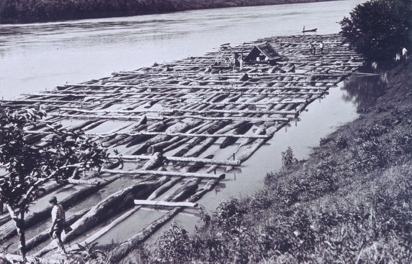
In the first decades of the twentieth century, the trunks
of the trees felled in the forest were transported to the Uruguay
River, where they were lashed together in rafts (fig. 2) and steered
downriver during the high-water season for sale in Argentina.
Rivers
of the Americas
rias vol. 14, spring–summer № 1/2021
Fig.2. Wooden raft in Mondaí, Brazil.Source: Archive of the Western Santa Catarina Memory Centre (CEOM) of the Chapecó
Region Community University (Unochapecó).
The journey lasted five to eight days and represented risks
for the workers who steered the rafts (Bellani 1991: 222–230).
Sometimes the timber was processed in sawmills before being
transported on the river, principally the trunks of Araucaria pine
210extracted from the Mixed Ombrophilous Forest, which was
review of international american studies
not abundant in areas near the Uruguay River.
conserving biodiversity
The activities of yerba mate harvesting, timber extraction
and the deforestation promoted by the colonization projects
focused on agriculture rapidly transformed the environment
and constructed a new landscape in the Uruguay River drain-
age basin. There was an accentuated loss of biodiversity during
the nineteenth and twentieth centuries. It is estimated that
the Temperate Deciduous Forest is one of the most devastated
environments of Brazil with just around 3% of the original area
remaining, distributed in small fragments that still suffer constant
anthropic pressures (Nodari 2017: 50). Some government initia- Eunice Nodari
tives resulted in the creation of conservation units, specifically Federal University
of Santa Catarina
two fully protected public parks close to the Uruguay River, which UFSC, Brazil
we discuss below. and
Marcos Gerhardt
The Turvo State Park was created in 1947, in the municipality University
of Derrubadas, RS, on the left shore of the Uruguay River, has of Passo Fundo
UFP, Brazil
a surface area of 17,491 hectares and aims to conserve an important
fragment of Temperate Deciduous Forest, inhabited by species
under risk of extinction like the collared peccary (Pecari tajacu),
the tapir (Tapirus terrestris) and many other species of reptiles,
amphibians, birds, mammals, insects, plants and fungi. Also living
in the Park are jaguars (Panthera onca), a large feline that “belongs
to the Panthera genus, like the lion (Panthera leo), tiger (Panthera
tigris) and leopard (Panthera pardus).” The jaguar “is the only pan-
ther of the Americas” (Franco and Silva 2020: 4) and is threatened
with extinction. In this Park, on the course of the Uruguay River,
is the Yucumã Falls, called the Moconá Falls by the Argentineans,
which is one of the world’s largest linear waterfalls (Sema 2005:
1). The falls are visited by tourists during the dry season when
they become more visible.
At exactly the same point of the river but on its right shore
is located Moconá Park, part of the Argentinean Selva Misionera
or the Bosque Atlántico del Alto Paraná, an enormous tract of forest
that extends from the Uruguay River many kilometers into the inte-
rior of Argentina as far as the Iguazú National Park and is home
211to diverse forms of wildlife. There are around 914,823 hectares
in areas of relatively continuous forest (República Argentina, 2007:
35). Currently, this forest is threatened by illegal timber extraction.
Due to its importance for the conservation of biological diversity,
especially the jaguar, the World Wide Fund for Nature (WWF)
included it on the list of priority ecoregions for global conserva-
tion (FVSA 2020; WWF 2020). The wildlife in the Turvo State
Park would be less abundant and diverse if the immense Selva
Misionera did not exist on the other side of the river, a permeable
frontier between the two countries. The circulation of animals
and genes between the two forest areas is of fundamental
importance for the conservation of biodiversity.
An important biodiversity place is the Espigão Alto State Park,
situated in the municipality of Barracão, RS, very close to the Uru-
guay River, has existed since 1949 and has an area of 1,325 hectares,
composed of Mixed Ombrophilous Forest and Dense Ombrophilous
Forest. It is classified under a full protection category, allowing
environmental education projects, and is home to an important
regional fauna at risk of extinction. However, its small size hinders
the conservation of some larger species of birds and mammals.
The Park’s vegetation includes species characteristic of the Upper
Uruguay River, like pineapple guava (Acca sellowiana), xaxim
(Dicksonia sellowiana) and jaborandi (Pilocarpus pennatifolius),
among others. The presence of invasive exotic plants (Pinus spp.,
Eucalyptus spp. and Hovenia dulcis) and the lack of public employees
Rivers to tend and manage the area were identified as problems in this
of the Americas
Park (Defap 2004: 40, 79, 122, 152).
rias vol. 14, spring–summer № 1/2021
The Fritz Plaumann State Park is a conservation unit situ-
ated along the Uruguay River, in the municipality of Concórdia,
in the Brazilian state of Santa Catarina, with an area of 741
hectares. It was created recently, in 2003, as a compensation
measure for the environmental impacts caused by the completion
of construction on the Itá Hydroelectric Plant in the year 2000.
This became the only conservation unit of Temperate Deciduous
Forest existing on the right shore of the Uruguay River. Although
the park contains a small conserved fragment of this forest, its cre-
ation allows the regeneration of the forest vegetation and functions
as a refuge for the region’s fauna. One problem is the presence
212of the exotic American bullfrog (Lithobates catesbeianus) in the area
review of international american studies
around the park (Fatma 2014: 25, 208, 213). This frog is a native
of North America and was introduced into Brazil, where it adapted
and now interferes in the dynamic of the communities of native
amphibians (Preuss 2017: 26).
Another small portion of conserved forest land is situated a few
kilometers from the Uruguay River, in the Nonoai Indigenous Land,
demarcated in 1911 by the Brazilian government for occupation
by Kaingang and Guarani populations of the region. This Indig-
enous land is 34,976 hectares in size, fifteen-thousand of which
comprise a forest reserve in which Mixed Ombrophilous Forest
predominates. From the 1960s to the 1990s there were conflicts
over lands involving indigenous peoples, farmers and the Rio Grande
do Sul state government. The result was the recent recognition
Eunice Nodari
of the indigenous population’s right to the land and to the forest Federal University
reserve for sustainable use, but the tensions and debates between of Santa Catarina
UFSC, Brazil
the two social groups, the government and the environmental- and
ists continue (Bringmann 2017: 179; Carini and Tedesco 2012: 55). Marcos Gerhardt
University
of Passo Fundo
0ther economic and cultural activities UFP, Brazil
Diverse economic activities were developed in the waters
and lands close to the Uruguay River. One of them is pig breeding
as small-scale livestock farming for the sustenance of caboclo
and settler families, for sale to local markets, or, more recently,
as producers integrated with the large pig and poultry abattoirs now
operating in the south of Brazil, in particular in the west of Santa
Catarina state. This industrial-scale activity exacerbated the prob-
lem of contamination of soils, surface waters and subterranean
waters by animal waste. Some of this contamination reaches
the Uruguay River via the affluents in the drainage basin (Winckler,
et al. 2017: 240–241). The flows of people and goods, between
one shore and the other and between the different municipalities
along the river, are known for the number of small ports, river
crossing points (passos) and bridges that exist. In the absence
of bridges, people and vehicles cross by ferryboat.
With the modernization of agriculture and the predominance
of soybean monocropping from the 1960s onward, the socio-envi-
ronmental problems worsened. The untreated urban and industrial
213waste and the residues of fertilizers and other agrochemicals that
reach the Uruguay River, further harm the quality of its waters,
according to studies conducted in farming regions on both sides
of the drainage basin (Ternus, et al. 2011; Fepam 2005).
As one of its solutions to the oil crisis of the 1970s, the Brazilian
government provided financial incentives through the National
Alcohol Program (Proálcool) to companies producing ethanol fuel
for automobiles and in the 1980s, the Alpox SA company installed
an ethanol plant in the region occupied by the São Francisco Xavier
mission. This site was chosen because the microclimate of the Uru-
guay River Valley prevents frost from forming and thus enables
sugar cane cultivation. Alpox SA soon closed due to financial
problems and a group of small farmers from the region, organized
in the Porto Xavier Sugar Cane Producers Cooperative (Cooper-
cana), took over the bankrupt company and reactivated the plant.
In 2004, after socioenvironmental studies, Coopercana obtained
an operating license. The main problem of this activity is treatment
of effluents and other waste generated before discarding them
in the environment, since they are pollutants and are produced
in large volumes (Rambo and Puhl 2005: 93; Coopercana 2004).
In 2011 Coopercana had 297 associates in Porto Xavier and neigh-
boring municipalities, mostly small family farmers, who found
ethanol production a stable source of income. In the same year
they harvested about 1,600 hectares of sugarcane and main-
tained, in their properties, the production of soybean for market
Rivers and food for self-consumption. Ethanol production in the state
of the Americas
of Rio Grande do Sul represented, in 2011, only 0.21% of Brazilian
rias vol. 14, spring–summer № 1/2021
production, concentrated in the state of São Paulo. Coopercana’s
production scale is small, but it has social importance, as it enables
family property and generates work and income, especially
in the period of manual harvesting and industrial production. Most
of the associates are descended from immigrants who settled
in the region in the colonization projects. Caboclos also inhabit
these lands of the Uruguay River Valley, but are peripherally linked
to the cooperative, usually as occasional workers (Coopercana
2004; Nascimento and Dörr, 2012).
Fishing for food, for trade or for sport is still a socially important
activity on the Uruguay River, but is jeopardized by the growing
214contamination of its waters. The production of irrigated rice may
review of international american studies
be contributing to this contamination since it uses chemical fertil-
izers, herbicides, and insecticides. The south of Brazil, Argentina
and Uruguay are rice producers on the floodplains of the drainage
basin of the middle and lower Uruguay River. This crop shares
the same space, a strip of permeable frontier along both shores
of the Uruguay River where the environmental conditions are
favourable for this agricultural model.
Frontier culture is present throughout the narratives and oral
tradition of the population living on the border region shared
by Brazil, Argentina and Uruguay (Hartmann 2005), in which
the river is a constant presence. Both sides of the border also
share a common history and memory, typified by the presence
of the Jesuit reductions, extensive livestock farming, trade in yerba Eunice Nodari
mate and wood, territorial conflicts, landscapes and biomes, flood Federal University
patterns, and the smuggling of goods (Flores 2012). In addition, of Santa Catarina
UFSC, Brazil
the coexistence of Brazilians, Argentines and Uruguayans developed and
a vocabulary that brought the Spanish and Portuguese languages Marcos Gerhardt
University
closer and a cultural identity. Moreover, three music festivals take of Passo Fundo
place in the border region and have the Uruguay River as one UFP, Brazil
of the themes: the Barranca Festival in São Borja, the Festival
of Thematic Music in Uruguaiana, both in Brazil, and the Corren-
tino Folklore Festival, held in São Tomé, Argentina. Furthermore,
the song “Balseiros do rio Uruguai,” composed by Barbosa Lessa
in the 1970s and made famous by the voice of Cenair Maicá, as well
other songs, adopt this river as the theme.
The knowledge, skills and tools of the ‘Balseiros,’ the wood raft
men, are understood today as being part of the cultural heritage.
In Itá, SC, the Balseiro Museum was created as an effort to highlight
the memory and heritage of this social group. The municipal-
ity schools in connection with the Museum, promotes student
consciousness of the ‘Balseiro’ activities. The aim to enhance
recognition of the ‘Balseiro’ cultural heritage by tourism promot-
ers, is an important economic activity linked to the Uruguay River
(Zen and Fontanari 2019).
The memories of living with the river also include floods, espe-
cially those that caused damage to homes, plantations and other
buildings, such as the flood of 1965. The sociability between
215the inhabitants on both shores of the Uruguay River has been
promoted, over the last decades, through popular parties and foot-
ball games. During the religious celebration in honor of The Virgin
of the Navigators, held in Porto Goio-Ên, in the municipality of Erval
Grande, RS, a river procession was organized, accompanied by songs
and Christian prayers. The flatter shores of the river, forming
beaches, are the space for leisure, rest, socializing and bathing
during the summer (Onghero and Franceschi 2009: 119–122).
hydroelectric plants
In the second half of the twentieth century various hydroelectric
plants were implanted in the basin of the Uruguay River. They
increased the generation of electricity for Brazil but created social
and environmental problems. We highlight some of the plants
that have had a major socio-environmental impact.
A consortium formed by four Brazilian public companies
and seven private companies, some of them transnationals, was
responsible for the construction of the Machadinho Hydroelectric
Plant from 1998 to 2001. The plant’s installation led to the dis-
appropriation of the lands of small farmers and to conflicts over
compensation payments for the losses or the resettlement
of affected families. The Brazilian government declared the project
a public utility and limited the right of defense of those people
living in the flooded area. The Movement of People Affected
by Dams (“MAB” or Movimento dos Atingidos por Barragens) played
Rivers an important role in the organization of the farmers, in negotiat-
of the Americas
ing with the consortium of companies and in the legal disputes
rias vol. 14, spring–summer № 1/2021
(Krzysczak 2019: 26, 33, 216; Consórcio Machadinho 2020: 1–2).
Another construction, the Itá Hydroelectric Plant, was built
on the Uruguay River between 1986 and 2001 following a conces-
sion of the Brazilian government for private corporations. The plant
project required the relocation of the town of Itá, located in the state
of Santa Catarina, and its residents in the 1990s to a new urban
area constructed close to the reservoir that flooded the original
town. Arable lands were also flooded, provoking the displacement
of small farmers, who organized to claim compensation payments
or resettlement, sometimes on lands far from those they lost.
As well as the environmental problems, the Itá Hydroelectric
216Plant produced changes in the landscape and cultural, symbolic
review of international american studies
and identity losses for the local populations (Klanovicz and Forcelini
2018: 176; Radaelli 2010: 52).
The Barra Grande plant was also built by a group of private com-
panies on the Pelotas River, one of the affluents that join to form
the Uruguay River and began to operate in 2005 with a regular
power output of 380 megawatts. The lack formed by damming
the river affected 1,516 farming families that had to leave their
lands and were settled in other places. The construction of this
plant is linked to the denunciation of fraud in its environmental
licensing, with the omission of the existence of around four-
thousand hectares of well-preserved Mixed Ombrophilous Forest
and other forms of secondary vegetation. The social mobilization
and legal processes were not sufficient, however, to prevent Eunice Nodari
the huge socioenvironmental damage caused by the construction Federal University
of this plant (Prochnow 2005: 6–14; Ruppenthal 2013: 20, 27, 64; of Santa Catarina
UFSC, Brazil
Espindola 2015: 161). and
People directly and indirectly affected by hydroelectric plants Marcos Gerhardt
University
call themselves “affected by dams” and are considered, broadly, of Passo Fundo
in international discussions as “environmental refugees” or “environ- UFP, Brazil
mental migrants” (Nodari 2017), as well as “victims of development”
(Renk and Winkler 2019). Whatever the term used, those affected
by the dams suffer the action of the agents of economic devel-
opment, which are the State and corporations, where they have
low capacity for reaction and negotiation. Most of the reaction
and negotiation actions can be attributed to the performance
of the Movement of People Affected by Dams (MAB), which took
its first regional steps in the 1980s, gradually transforming itself
into a national organization active in defense of those affected.
The hydroelectric plants avoid, almost entirely, the reproduction
of migratory fish and decreased fishing in some parts, particu-
larly when the water is diverted from the original river course,
as in hydroelectric Foz do Chapecó (Oliveira and Aguiar 2013).
Recently, the construction of the Garabi-Panambi Binational
Hydroelectric Complex on the border between Argentina and Brazil
came into debate. The complex would be built with public and private
financial resources from both countries (Rocha and Nunes 2017;
Eletrobras 2013). The construction of the two projected hydro-
217electric plants will affect the territory and population of dozens
of municipalities in Brazil and Argentina. Several public, religious
and community institutions on both sides of the river have mobilized
against the project, which threatens fundamental human rights.
One of the points of tension for the environmental movements
refers to the Salto do Yucumã and “the Turvo State Park, which
also corresponds to the Core Zone of the Atlantic Forest Biosphere
Reserve, which would be affected by the Panambi hydroelectric
plant.” In 2015, after social pressure, the Brazilian Federal Court
suspended the environmental licensing of the project (Nodari 2017:
60–61). In 2016, was created the Movement of People Affected
by Hydro-Dams (MAR) in Latin America, which goes beyond national
borders in defense of populations that have common problems.
On the other hand, in 2019, the governments of Brazil and Argentina
again discussed the resumption of the Garabi-Panambi hydroelectric
project, with a risk of worsening socio-environmental conflicts
in the Uruguay River basin.
The arguments of the companies are based on the demand
of energy for industrial activities and also of the lower economic,
social and environmental relative cost of hydroelectric energy.
Private companies that invest in the construction of hydroelec-
tric plants are also the main consumers of the energy generated.
Compared to thermal and nuclear power, hydroelectric power is
considered clean and cheap by investors; however, social movements
defend another model, decentralized and based on alternative
Rivers forms of generation, such as solar, wind power and small hydro-
of the Americas
electric plants (Oliveira and Aguiar 2013). Currently, alternative
rias vol. 14, spring–summer № 1/2021
ways to thermal, nuclear and hydroelectric plants, such as solar
and wind power are increasing in the country and are the ones that
causes less damage to the environment, to the culture heritage
and to the people.
final considerations
One constant over the course of the centuries is the com-
plexity of human interaction with the Uruguay River. Different
human groups relate in diverse ways to the waters and the lands
close to the river, a space that includes both the landscape
and the dynamic of the interactions that happen there. While
218some human populations, like the Guarani and Kaingang indig-
review of international american studies
enous peoples and the caboclos, established a lengthy symbiosis
with the river and with the valley’s forests, the settlers produced
a rapid transformation marked by deforestation and agriculture.
The forests exalted within the pages of travel reports in the past
and very often seen as obstacles by the immigrants lost space
to industry and to commerce in the villages. In the rural areas, agri-
culture and livestock farming completely changed the landscape.
With the modernization of agriculture from the 1960s, this process
of altering the landscapes and ecosystems quickened pace. Today
there remain small isolated fragments of Mixed Ombrophilous
Forest and Temperate Deciduous Forest in the Brazilian territory,
conserved in parks and protected areas that confront a variety
of problems toward their goal of conserving biodiversity and eco- Eunice Nodari
systems. Federal University
Today, farming based on monocrops, chemical inputs, mech- of Santa Catarina
UFSC, Brazil
anization, and irrigation does not promote the conservation and
of water resources, biodiversity, and ecosystems, or protect Marcos Gerhardt
University
human health. In the words of Donald Worster, we need more of Passo Fundo
than a technical vision, we “require a new form of perception, new UFP, Brazil
mental frameworks, a new ethics regulating agricultural practices
and policies” (2008: 38). It demands “learning to think like a river.”
Worster refers mainly to large-scale irrigated agriculture, practiced
in the United States of America and other parts of the world. This
model of agriculture is not present on the banks of the Uruguay
River, but the author’s argument that this and other human
activities require water and must respect the limits established
by hydrological cycles, applies to the region under study. Many
of the actions and interactions with the Uruguay River in recent
decades have been motivated by economic interests and have
disrespected the dynamics of waters and ecosystems. The main
intervention was the damming of the river, the interruption of its
natural flow and the alteration of the way of life of social groups
whose culture was linked to its waters.
The construction of hydroelectric plants along the Uruguay River
has environmental and social costs that must be re-evaluated
by human societies. The small amount of electricity generated
by the Barra Grande Hydroelectric Plant, for example, when
219compared to other hydroelectric plants in Brazil, fails to justify
the immense and irreparable environmental damage provoked
by its construction. The settlers, those who settled in the Uru-
guay valley as small farmers in previous decades, were affected
by the waters of the river, dammed to form the plant reservoirs.
Since the 1980s, several organized social movements, especially
the MAB, have challenged the industrial development model based
on the construction of hydroelectric dams. These movements
exist on both sides of the river, in Brazil and Argentina, because
social and environmental problems are common. Hydroelectric
projects sometimes bring together the interests of governments
and private corporations that operate beyond the national border
demarcated by the river.
Over the period studied, the Uruguay River was a permeable
frontier. It permitted and promoted interactions among the human
societies who lived on its shores and between them and the river.
More than a border between different territories and countries,
it marked a space of relations and created a border zone in which
the river is an essential element. Culturally, an identity linked
to the river was created, a feeling of belonging to that territory,
an appreciation of the landscapes of its banks and the recogni-
tion of the river as a socio-environmental heritage. This identity
was formed through the long historical trajectory of coexistence
and interaction of various human groups with the Uruguay River,
composed of individual and collective memories related to change
Rivers and continuity in the natural and built environments of this
of the Americas hydrographic basin.
rias vol. 14, spring–summer № 1/2021
220works cited
review of international american studies
Ambrosetti, Juan B. Dos estudios sobre Misiones: Viaje a las Misiones
argentinas y brasileras por el Alto Uruguay. Rapida ojeada
sobre el Territorio de Misiones. Estudio preliminar Alfredo S.V.
Bolsi. Instituto de Investigaciones Geohistóricas, 1983.
Arruda, Gilmar (Ed.). A natureza dos rios: história, memória e territórios.
UFPR, 2008.
Bellani, Eli M. Madeira, balsas e balseiros no rio Uruguai: o processo
de colonização do velho município de Chapecó (1917/1950).
Dissertação (Mestrado em História), Universidade
Federal de Santa Catarina, 1991. repositorio.ufsc.br/han-
dle/123456789/75716. Accessed 19 Apr. 2020.
Beschoren, Maximiliano. Impressões de viagem na província do Rio
Grande do Sul: 1875–1887. Martins Livreiro, 1989. Eunice Nodari
Federal University
Bracco, Diego. “Los guenoa minuanos misioneros.” Memoria Americana, of Santa Catarina
UFSC, Brazil
Cuadernos de Etnohistoria, vol. 24, no. 1, 2016, pp. 33–54, doi. and
org/10.34096/mace.v24i1.2612 Marcos Gerhardt
University
Bringmann, Sandor Fernando. “Entre decretos, disputas judiciais of Passo Fundo
e conflitos armados: batalhas entre Estado, camponeses UFP, Brazil
e indígenas pela posse da Reserva Florestal de Nonoai/RS.”
História ambiental e migrações: diálogos, edited by Marcos
Gerhardt, Eunice S. Nodari and Samira P. Moretto, Oikos,
UFFS, 2017, pp. 177–192.
Capilé, Bruno. Os muitos rios do Rio de Janeiro: transformações e inte-
rações entre dinâmicas sociais e sistemas fluviais na cidade do
Rio de Janeiro (1850–1889). Tese (Doutorado em História), Uni-
versidade Federal do Rio de Janeiro, 2018.
Carini, Joel, and João Carlos Tedesco. “O Conflito de Nonoai: um marco
na história de lutas pela terra.” História do Campesinato
na Fronteira Sul, edited by Paulo A. Zarth, Letra & Vida, Uni-
versidade Federal da Fronteira Sul, 2012, pp. 33–57.
Castro, Evaristo Affonso de. Notícia descriptiva da região missioneira
na província de São Pedro do Rio Grande do Sul. Typographia
do Commercial, 1887.
Consórcio Itá. Itá: memória de uma usina. 2020. www.consorcioita.com.
br/fmanager/consorcioita/livro/arquivo1_1.pdf. Accessed 20
Mar. 2020.
221Consórcio Machadinho. 2020. www.machadinho.com.br/. Accessed 13
Aug. 2020.
Coorpercana. Cooperativa dos Produtores de Cana Porto Xavier. Estu-
dos socioambientais visando a obtenção da licença de operação.
2004.
Dean, Warren. A ferro e fogo: a história e a devastação da Mata Atlân-
tica brasileira. Companhia das Letras, 1996.
Departamento de Florestas e Áreas Protegidas do do Rio Grande do Sul
(Defap). Plano de Manejo do Parque Estadual de Espigão Alto.
2004. www.sema.rs.gov.br/parque-estadual-de-espigao-
alto. Accessed 15 May 2020.
Dreys, Nicolau. Notícia descriptiva da província do Rio Grande de São
Pedro do Sul. Nova Dimensão, EdiPUCRS, 1990.
Eletrobras. UnE Garabi-Panambi. 2013. eletrobras.com/pt/Paginas/
UnE-Garabi-Panambi.aspx. Accessed 12 Jan. 2021.
Espindola, Haruf. Sertão do Rio Doce. Edusc, 2005.
Espindola, Marcos Aurélio. “Tecnização de natureza: o desastre ambi-
ental da Usina Hidrelétrica de Barra Grande (SC).” Desastres
socioambientais em Santa Cararina, edited by Eunice S. Nodari,
Marcos A. Espindola and Alfredo R. S. Lopes, Oikos, 2015,
pp. 157–181.
Fatma. Fundação Estadual de Meio Ambiente de Santa Catarina. Plano
de Manejo do Parque Estadual Fritz Plaumann: Fase 2. 2014.
Rivers www.ima.sc.gov.br/index.php/biodiversidade/unidades-de-
of the Americas
conservacao/parque-estadual-fritz-plaumann. Accessed 18
rias vol. 14, spring–summer № 1/2021
May 2020.
Fepam. Fundação Estadual de Proteção Ambiental Henrique Luiz
Roessler, RS. Região hidrográfica do Uruguai. 2005. www.
fepam.rs.gov.br/qualidade/regiao_uruguai.asp. Accessed 12
Feb. 2020.
Ferrasso, Suliano, and Pedro Ignácio Schmitz. “Arqueofauna de um sítio
guarani em Itapiranga, no vale do alto Uruguai (SC, Brasil).”
Cuadernos del Instituto Nacional de Antropología y Pensam-
iento Latinoamericano, vol. 4, no. 1, 2013, pp. 127–136. ppct.
caicyt.gov.ar/index.php/cinapl-se/issue/view/257/showToc.
Accessed 15 May 2020.
222review of international american studies
Flores, Mariana F. da Cunha Thompson. “Contrabando na fronteira
meridional do Brasil: por fora e por dentro da Alfândega
(1845–1889).” Revista Brasileira de História & Ciências Sociais,
vol. 4, no. 7, Jan.-June 2012, pp. 122–142. seer.furg.br/rbhcs/
article/view/10470. Accessed 13 Jan. 2021.
Franco, José L. de A., and Lucas G. Da Silva. “História, ciência e con-
servação da onça-pintada nos biomas brasileiros.” Estudos
Ibero-Americanos, vol. 46, no. 1, Jan.–Apr. 2020, pp. 1–18. doi.
org/10.15448/1980-864X.2020.1.33911
Fvsa. Fundación Vida Silvestre Argentina. Selva Misionera. 2020. www.
vidasilvestre.org.ar/. Accessed 11 Apr. 2020.
Gerhardt, Marcos. História ambiental da Colônia Ijuhy. Editora Unijuí,
2009.
Eunice Nodari
——————. História ambiental da erva-mate. Tese (Doutorado em História), Federal University
Universidade Federal de Santa Catarina, 2013. gerhardt.pro.br/ of Santa Catarina
UFSC, Brazil
doc/historia-ambiental-erva-mate.pdf. Accessed 9 Apr. 2020. and
Marcos Gerhardt
——————. “Os caboclos e a relação com a natureza no norte do Rio University
Grande do Sul.” Ciência & Ambiente, vol. 1, no. 33, July-Dec. of Passo Fundo
2006, pp. 165–174. UFP, Brazil
Giehl, Eduardo L. H. (Coord.), 2020. Flora digital do Rio Grande do Sul e de
Santa Catarina. floradigital.ufsc.br/. Accessed 8 May 2020.
Golin, Tau. A fronteira: 1763–1778, vol. 3. Méritos, 2015.
Harres, Marluza M., and Fabiano Quadros Rückert. A natureza, o tempo
e as marcas da ação humana: políticas públicas e ambiente em
perspectiva histórica, São Leopoldo, RS. Oikos, 2015.
Hartmann, Luciana. “Performance e experiência nas narrativas orais
da fronteira entre Argentina, Brasil e Uruguai.” Horizontes
Antropológicos, vol. 11, no. 24, July-Dez. 2005, pp. 125–153. doi.
org/10.1590/S0104-71832005000200007
Isabelle, Arsène. Viagem ao Rio da Prata e ao Rio Grande do Sul. Trans-
lated by Teodemiro Tostes. Senado Federal, 2006.
Itasa. Itá Energética SA. Usina Hidrelétrica Itá. 2020. www.consorcioita.
com.br/. Accessed 17 May 2020.
Jorge, Janes. Tietê, o rio que a cidade perdeu: São Paulo, 1890–1940.
Alameda, 2006.
223Klanovicz, Jo, and Melody Forcelini. “A Usina Hidrelétrica de Itá, Bra-
sil e a tecnologia de força bruta na história recente do rio
Uruguai.” Inclusiones, vol. 5, número especial, Jan.-Mar 2018,
pp. 175–191. www.archivosrevistainclusiones.com. Accessed
14 May 2020.
Krzysczak, Fabio Roberto. Relações de poder acerca da propriedade
no processo de construção da usina hidrelétrica de Machadinho
RS (1980–2010). Tese (Doutorado em História), Universidade
de Passo Fundo, 2019.
Leonardi, Victor. Os historiadores e os rios: natureza e ruína na Amazô-
nia brasileira. Paralelo 15, 1999.
Lindman, Carl Axel Magnus, and M.G. Ferri. A vegetação no Rio Grande
do Sul. Itatiaia, Universidade de São Paulo, 1974.
Linhares, Temístocles. História econômica do mate. José Olympio Edi-
tora, 1969.
Marcuzzo, Francisco F. N. “Bacia hidrográfica do rio Uruguai: altimetria
e áreas.” Anais do XXII Simpósio Brasileiro de Recursos Hídricos,
2017. rigeo.cprm.gov.br/jspui/bitstream/doc/18489/1/2017_
sbrh_bacia_rio_uruguai_artigo.pdf. Accessed 12 Mar. 2020.
Middeldorf, Carl. Porto Novo: Urwaldsiedlung deutscher Katholiken
in Südbrasilien. Typographia do Centro, 1932.
Miranda, Francisco Nunes de. Sobre os diferentes ervais, sua extensão,
uberdade e cultura. 1859. Arquivo Histórico do Rio Grande
Rivers do Sul.
of the Americas
Nascimento, Adriana Rosa do, and Andrea Cristina Dörr. “Peculiarities
rias vol. 14, spring–summer № 1/2021
of sugar cane production in the State of Rio Grande do Sul:
A case study in the Missões region.” Perspectiva Econômica,
vol. 8, no. 2, July-Dec. 2012, pp. 82–97. dx.doi.org/10.4013/
pe.2012.82.02
Nodari, Eunice S. “Fronteiras invisíveis? história ambiental e imigra-
ções.” História: poder, cultura e fronteiras, edited by Maria
Medianeira Padoin and Ana Frega Novales, FACOS-UFSM,
2017, pp. 43–65.
——————. “Um olhar sobre o Oeste de Santa Catarina sob o viés
da História Ambiental.” História: Debates e Tendências, vol. 9,
no. 1, 2009, pp. 134–148. doi.org/10.5335/hdtv.9n.1.3212
224You can also read