THE UK'S FIRST SANDSCAPING PROJECT - FROM IDEA TO REALITY: PROJECT - IADC Dredging
←
→
Page content transcription
If your browser does not render page correctly, please read the page content below
PROJECT

FROM IDEA TO REALITY:

THE UK'S FIRST
SANDSCAPING
PROJECT              All Photos © Chris Taylor

32   TERRA ET AQUA
The northeast Norfolk
coast has been subject
to long-term coastal
The Bacton Sandscaping scheme is a large-scale change. It is likely that
beach nourishment designed to protect the Bacton Gas the cliffs have been
Terminal from cliff and beach erosion while also reducing
flood and erosion risk to the communities of Bacton eroding at around the
and Walcott, buying the time needed for adaptation to present rate for the
coastal change. The scheme was inspired by the Sand last 5,000 years.
Engine project in The Netherlands but has translated
the concept to the different geography and governance
setting of the UK. It can be seen as the Sand Engine’s
‘little nephew’.
The northeast Norfolk coast has been subject The Bacton Gas Terminal is situated on buried within the cliffs and beach. There was
to long-term coastal change. It is likely that the the North Norfolk coast, approximately 30 therefore an urgent need to provide protection
cliffs have been eroding at around the present kilometres north of Great Yarmouth. The against further erosion. In January 2017, due
rate for the last 5,000 years. The cliffs are Terminal has infrastructure near the cliff to the immediate risk, Shell constructed a
made of soft deposits – mainly sand and soft edge, within the cliff and under the beach. temporary coast protection solution along
clays – which are very vulnerable to erosion. It is a piece of nationally important critical critical lengths of their section of the Terminal
This long-term coastal change puts pressure infrastructure supplying up to one third of frontage. This temporary solution consisted of
on communities, infrastructure and business the UK’s gas demand from the North Sea rock-filled gabion baskets placed at the toe of
in the coastal zone. extraction fields and to and from the continent. the cliffs on a gabion mattress and backfilled
The Terminal is owned by Shell, Perenco as with sand. The temporary solution was
well as other oil and gas businesses. The Gas designed to provide intermediate protection
Terminal requires protection from cliff erosion and assumed construction of a full permanent
and beach lowering for as long as the Terminal scheme would be performed in the near
is needed to avoid national impacts in the future. The vulnerability of the Gas Terminal
event of the gas supply being interrupted. infrastructure to erosion was highlighted again
in the storm surge event of January 2017
The Terminal was defended by a series of which caused significant lowering of the beach
timber groynes which sought to manage beach and damage to the existing timber revetment
levels and a timber revetment to reduce cliff and the temporary coast protection solution
erosion (see Figure 1). These structures were which was in the process of being constructed.
more exposed due to beach lowering, suffered
damage during storm events and only provided Southeast of the Bacton Gas Terminal,
protection against 10% Annual Exceedance continued coastal protection of the villages
Probability (1:10 per year) storms. of Bacton and Walcott (referred to as ‘the
Villages’ within this article) was only likely
Despite these defences, cliff erosion at the to be economically viable in the short-term
Terminal had progressed rapidly over the years, under current UK treasury rules. The Villages
notably during storm surges in November form an integral element of the community
2007 and December 2013. Following the and socio-economic structure of northeast
December 2013 storm it became clear Norfolk, providing residential areas supporting
FIGURE 1 that erosion was starting to threaten the the population and overall housing stock of
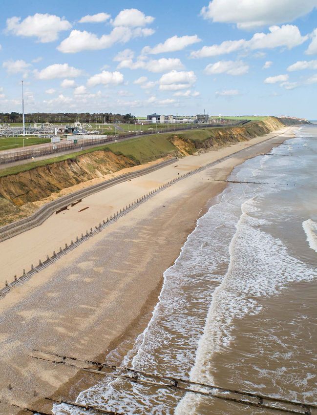
Defences at Bacton Gas Terminal prior to infrastructure at the Terminal. This included the area. They contribute to the important
Sandscaping. the cliff top infrastructure itself and pipelines tourism potential to the area and sustain small
#158 - SPRING 2020 33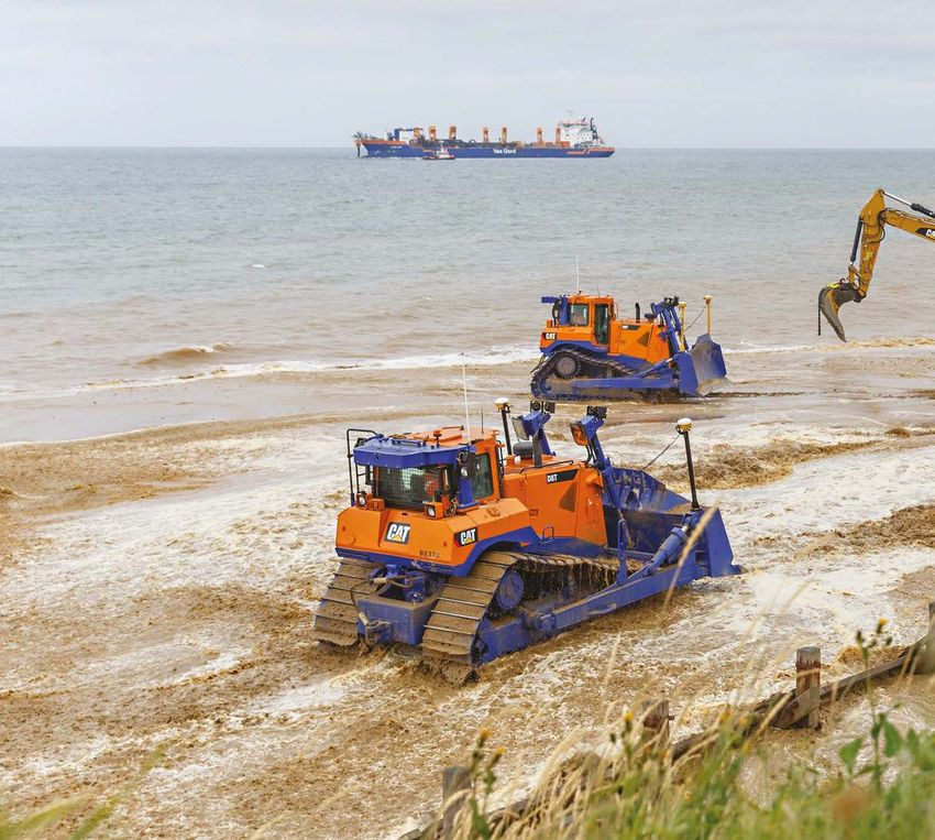
PROJECT

 FIGURE 2

Location Plan with red line denoting
Sandscaping placement (Royal HaskoningDHV,
2018).

businesses that also form part of the support
structure to the wider rural hinterland. The
Villages are protected from coastal erosion
and flooding by a concrete seawall along most
of their length, flanked by timber revetment.
These defences were supported by a timber
groyne field which, due to falling beach levels
preventing access, were in varying states of
repair. All the defences relied on the beach as
the first line of defence to reduce water depth
and, therefore, the height of the waves that can
reach the defences, as well as protecting the
lower part of the seawall from direct exposure     economically viable. This is only expected to      ranging from a traditional regular nourishment
to waves while also providing structural           be possible in the short term, but before the      to a sandscaping solution with its larger
support. The beach had eroded significantly        sea defences fail, measures will be required to    scale, intent to work with natural processes
since the construction of the seawall in the       manage the risk and mitigate the displacement      and intent to generate multiple benefits. In
1950s and 60s to a point where the seawall         of people and loss of property and facilities in   particular, the Dutch Sand Engine project has
was predicted to have a residual life of only      the medium term.                                   demonstrated major recreational benefits and
5 to 15 years. The erosion of the beach also                                                          would be ideally replicated by the scheme.
increases flood risk: the storms of 2007, 2013     This means that any ‘hard’ solutions could
and 2017 caused significant flooding of the        only work if complemented by significant           Development of the solution
coastal road and properties due to waves.          beach nourishment to counteract the                From terminal-only to a combined
                                                   negative impact to the Villages due to wave        solution
The challenges                                     overtopping. ‘Hybrid’ solutions were also          The North Sea tidal surge of 5 December 2013
As the coastline changed, parties were faced       considered, including the placement of rock        was the key event which spawned the project,
with complicated decisions about how and           armour with additional sand. However, these        leading to the UK’s inaugural sandscaping
where to defend. Economics, communities,           were discounted. Initial appraisal subsequently    scheme. In this event, several metres of soft
the environment and physical geography all         determined that these ‘hybrid’ solutions would     cliff in front of the Gas Terminal were lost
played a part in these decisions. Full ‘hard’      be less attractive than sand-only solutions.       to the concern of the terminal’s operators.
defences along the entire coast were not                                                              Similarly, at Bacton and Walcott there was
an option because they were not affordable,        In 2013, Royal HaskoningDHV had already            infrastructure and housing damage caused by
environmentally acceptable or sustainable and      identified that a large-scale sandy solution       the storm waves and flooding. The terminal’s
can exacerbate erosion.                            could work for the northeast Norfolk coast         operators immediately secured the services of
                                                   through a study for North Norfolk District         engineering consultants Royal HaskoningDHV
Bacton Gas Terminal urgently needed to             Council and The Crown Estate. This was part of     to assess options to eliminate erosion risk to
be protected against coastal erosion. The          the UK-wide sandscaping initiative which aims      the Terminal.
Shoreline Management Plan (SMP), adopted           to explore application of coastal management
in August 2012, set out the agreed intent          approaches inspired by the Dutch Sand Engine       While the team was developing solutions for
of management of the coast for the short,          project. Sandscaping solutions are large-          the Terminal, meetings were held with North
medium and long term. The SMP states that          scale beach nourishments that are designed         Norfolk District Council and Environment
protection of the Terminal is acceptable but       to work with natural processes and with the        Agency to share initial findings and explore
only if it does not increase erosion at the        intention of achieving multiple objectives.        the possibilities around joint development
neighbouring villages of Bacton and Walcott.       However, the Bacton-specific study still had       of a project with North Norfolk District
For the Villages, the SMP states that the sea      to confirm the preferred concept (in terms         Council. These meetings and discussions
defences should be maintained as long as           of scale and shape) for the sandy solution,        led to an option being explored of a public/

34           TERRA ET AQUA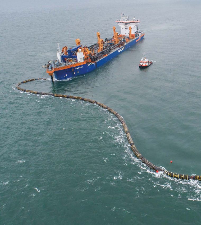
Fine-tuning
        ● Analysis                                                   ● Analysis
                                       ● Analysis
        ● Contractor engagement
                                       ● Contractor engagement       ● Contractor engagement
        ●   EIA
                                       ● EIA                         ● EIA                          The northeast Norfolk
                  Initial design                                              Finalisation
                                                                                                    coast has been subject
                                                                                                    to long-term coastal
                                                                                                    change. It is likely that
 FIGURE 3

Design process.                                                                                     the cliffs have been
                                                                                                    eroding at around the
private sector collaboration to deliver a           Villages, thereby extending the life of the     present rate for the
collective solution to address erosion risk at      Villages and reducing their risk.
the Terminal and flood and erosion risk at the                                                      last 5,000 years.
villages of Bacton and Walcott. The work for        Design process
the terminal companies had confirmed that a         The aim of the subsequent stage was to refine
sandy solution could be designed to prevent         the design of the sandy solution (in terms of
downdrift impacts; now the challenge was to         volume, shape, renourishment interval and
develop this to a sustainable and affordable        sediment size) while initiating the process
solution that would improve the beach at the        toward the statutory consents, in particular

 FIGURE 4

Sand extracted from the seabed is pumped onshore through a pipeline.

                                                                                                          #158 - SPRING 2020   35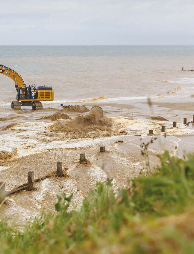
PROJECT
The team made a the Marine License and Planning Permission. conceptual model was agile enough for
The team followed an iterative approach with optioneering while fully representing the beach
special effort to three parallel tracks: processes. The conceptual model uses the
1. analysis (including modelling), one dimensional Litline model as the central
engage closely with 2. environmental study, and engine and uses the other tools to add cross
3. engagement with contractors sectional processes which cannot be captured
all contractors on the (see Figure 3). by the one-dimensional model on its own. This
relates specifically to the loss of sediment
Environment Agency The iterations concerned sediment volume, toward deep water and the development of the
various configurations and shapes, distribution cross-sectional shape of the beach (i.e. the
framework throughout between Terminals and Villages, sediment size. long-term balance between offshore losses
The process converged gradually toward the and onshore recovery). The overall shape and
the design process. finally chosen selection, informed by insights volume of nourishment at the Terminal was
derived from each of the three workstreams. technically assessed and optimised using
cross-sectional modelling. The Terminal
Modelling and analysis element was designed to provide protection
To assess the technical performance, a against cliff erosion in storms up to a 0.01%
conceptual model was used that combined Annual Exceedance Probability (1:10,000
the strengths of a one-dimensional (Litline) per year) event. The team developed an
and a two-dimensional area model (coupled innovative approach using hydrodynamic wave
wave, TOMAWAC, flow, TELEMAC-2D and modelling with AMAZON to compare design
sediment transport, SISYPHE, models within wave loading on the cliff face with known
the TELEMAC-MASCARET modelling system; historic storms that did not cause erosion. In
run by HR Wallingford) with appropriate use addition, plume modelling was carried out to
of expert knowledge and judgement and local inform the Environmental Impact Assessment
information (in particular from the Coastal (EIA) and for wind-blown sand, a research
Monitoring Programme). The resulting model developed for the Dutch Sand Engine
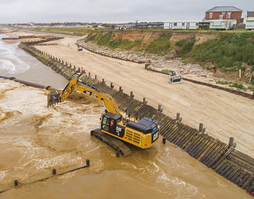
FIGURE 5
View of shoreline nourishment with various equipment at work.
36 TERRA ET AQUA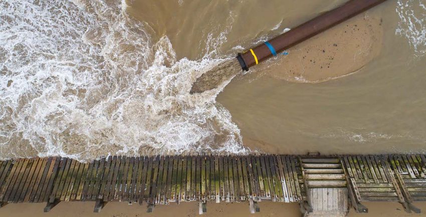
A                                                                             B

                   SE                                                                             SE

                                       NW                                                                            NW

 FIGURE 6

Schematic overview looking from north to south along the coast, before (A) and after (B).

was used to test impacts on the terminals           important for a scheme like this – which was        up to 80 metres, and then sloping down to
and community as well as inform the design          dominated by dredging and nourishment               the existing sea bed. The existing outfall pipes
of mitigating measures. Modelling studies           operations – because operations depend on           were replaced with a new single buried pipe.
considered placing greater volumes of sand          the specific (often commercially sensitive)
around the Terminal in a hemispheric shape,         characteristics of the contractors’ equipment.      Element 2: Villages
similar to the Dutch Sand Engine. However,          The team initially considered engaging with         This element provides additional protection in
limited benefit was offered by the additional       a single selected contractor but the chosen         front of the Villages from Bacton to Walcott for
volumes. Modelling showed that tidal currents       approach of working with multiple contractors       which the proposed scheme is considered the
in the area washed the additional volume away       in parallel has proven to work well, also           only viable solution. The initial sand placement
very rapidly.                                       because it helped sustain a level playing field     improves beach levels which in turn increases
                                                    for contractor procurement. This process has        the life of the existing sea defences. Over time,
Environmental study                                 influenced size, shape and grain size of the        tide and waves will transport sand from the
The environmental study was not only carried        nourishment.                                        Terminals nourishment to feed the beaches
out to meet statutory requirements (EIA,                                                                of the villages. The higher and wider beach will
Habitats Regulations, Marine Conservation           What was proposed?                                  also reduce wave overtopping and therefore
Zone Assessment, Water Framework Directive)         The Sandscaping scheme consisted of the             flood risk for the Villages. The Villages element
but played a strong and driving role through        placement of sand along the coastal stretch         runs from the south-eastern end of the
the design process, both in terms of designing      between the Terminal and the south-eastern          Terminals down to the end of the scheme at
out negative impacts and incorporating              end of Walcott. This is a stretch of coast of 5.7   Ostend, Walcott and contains approximately
mitigation as well as in terms of incorporating     kilometres. The scheme comprises two distinct       0.8 million cubic metres of sand. The initial
opportunities for enhancement. The project          but connecting elements: the nourishments           beach level covered the exposed sea wall toe,
identified a chalk bed near the coast within the    in front of the terminals and in front of the       at 4 to 5 metres AOD with a crest width up to
Marine Conservation Zone and this influenced        Villages (as shown in Figure 2).                    about 25 metres, and then sloped down to the
the design to minimise the risk that the chalk                                                          existing seabed. The crest at 4 metres AOD
bed would be impacted by the scheme. The            Element 1: Terminals                                means that there would (at least) initially be
environmental study also influenced the grain       This element aims to prevent significant            a beach at high water. The coast would still
size and spawned the idea of stimulating dune       cliff erosion up to a storm event with a 0.01%      erode, including temporary rapid losses during
growth on the nourishment with the added            Annual Exceedance Probability (1:10,000 per         storm events. However, the scheme would have
benefit of limiting wind-blown sand.                year). The initial placement of sand is expected    ‘turned back the clock’ by several decades
                                                    to last approximately 15 to 20 years from first     and the extra sand would make the beach
Contractor engagement                               placement with the intention to potentially         more robust with the ability, under the right
The team made a special effort to engage            re-nourish after that period. The terminals         conditions, to naturally recover.
closely with all contractors on the Environment     element covers the terminals frontage down
Agency framework throughout the design              to the adjacent Holiday Park and contains           Overall
process. All potential contractors were invited     approximately 1 million cubic metres of sand.       The total sand volume of 1.8 million cubic
and all became very positively involved, helping    The nourishment here is at its widest and           metres was extracted from the seabed, from
to optimise scheme design and increasing            highest: 3.5 to 5 metres higher than the            an existing licensed site, off Great Yarmouth.
confidence in the cost estimates to the             current beach at the cliff toe (7 metres Above      The extraction sites are approximately 20-25
benefit of the clients. This is particularly        Ordnance Datum (AOD)), with a crest width           nautical miles from Bacton. The sand grains

                                                                                                                    #158 - SPRING 2020                37
PROJECT

will be similar to the current beach (D50           has shown that this alignment is the most         timing dependent on weather conditions and
of 0.35mm), or slightly coarser (D50 up to          favourable.                                       to be confirmed through ongoing monitoring
1.2mm). Generally, coarser sand is more stable                                                        and review). A future placement may be
so will create a more stable beach but it is also   The placed beaches will adapt rapidly to          designed to continue to protect the Terminals
more expensive to place, and if too coarse, it      the natural conditions. The sand will spread      – probably without future placements in front
could have impacts on amenity use or habitats.      out along the coast in both directions. The       of the Villages – depending on considerations
The sand placement in front of the Terminal         scheme is expected to provide the required        at that time. The improved beach in front
provides immediate protection and narrows           level of protection at the Terminal’s coast for   of the villages of Bacton and Walcott is
towards the villages (see Figure 6). Modelling      approximately 15-20 years (with the exact         expected to enhance the lifespan of the

38           TERRA ET AQUA
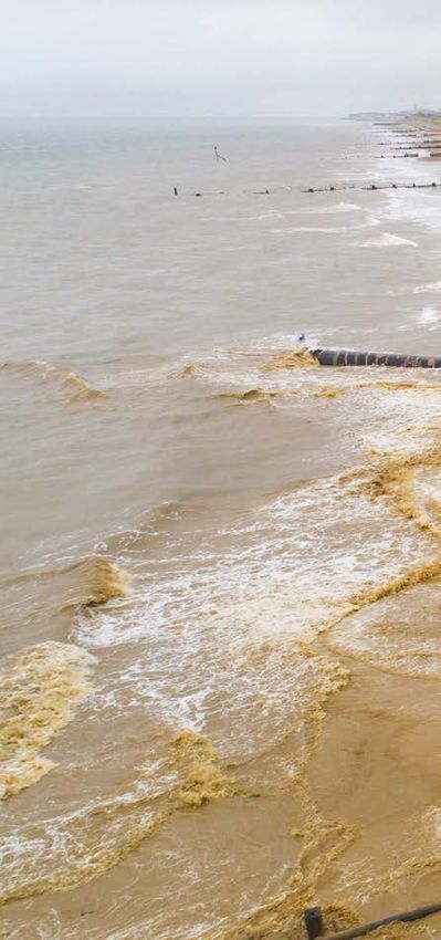
FIGURE 7

                                                                                                     Total sand volume of 1.8 million cubic metres
                                                                                                     was extracted from the seabed, from an existing
                                                                                                     licensed site, off Great Yarmouth.

                                                                                                      The beach plays an
                                                                                                      important role of
                                                                                                      absorbing the energy
                                                                                                      from the sea before it
                                                                                                      reaches the cliff and
                                                                                                      defences while also
                                                                                                      providing support
                                                                                                      and protection to the
                                                                                                      defence foundations.

existing sea defences. The sandscaping           approximately 400 OMs (Outcome Measures)            damages, and the direct damages to the
scheme could delay sea defence failure by        under current UK Government funding criteria.       Terminal facilities.
15 to 50 years depending on the state of the
seawall and beach development over time.         Benefits                                            For the Villages, the scheme is expected to
This significantly delays the loss to erosion    The scheme will have very large benefits to         delay the loss of the seawall, and thereby
of nearly 300 households. It is also predicted   the Gas Terminal, extending its functional life     delay the loss to erosion of the coast road and
to reduce flood risk due to overtopping to       as a piece of nationally critical infrastructure,   nearly 300 households. In addition to these
the coast road and over 100 households.          preventing potential (very expensive) national      measurable benefits, the scheme is expected
Therefore, the scheme is delivering              disruption of supply and its consequential          to provide time to the communities to adapt to

                                                                                                                 #158 - SPRING 2020              39
PROJECT

coastal change, for which they currently have             previous studies, updated to the current       Happisburgh and then also at Eccles
very little time and opportunity.                         date, were used to estimate how the            and Sea Palling. Due to the significant
                                                          scheme options would generate benefits.        uncertainty regarding these possible
Following discussion with DEFRA and the                   In addition, the number of households          benefits, and the fact that its inclusion is
Environment Agency the village element of the             for which the scheme options reduce the        outside of current policy guidance, these
scheme is eligible for government Flood and               probability of flooding, was estimated on      additional benefits have not been calculated
Coastal Erosion Risk Management (FCERM)                   the basis of data from the Environment         within the approved business case
Grant in Aid (GiA) funding as set out in the              Agency’s coastal modelling study. These        submitted to LPRG.
following list:                                           two results were combined to determine
• Properties protected from erosion,                      the scheme options’ economic benefits          The scheme is expected to create other
    determined by applying the standard                   and their contribution to Outcome              benefits which are not eligible for GiA
    methods from the Environment Agency                   Measure 2 (households moved from a             because they do not relate to reduction of
    approved Economic Appraisal Manual.                   high flood risk category to a comparatively    flood and erosion risk. This concerns the
    Essentially, the benefits are generated               lower category).                               enhancement of the communities’ capacity
    by the delay of the loss to erosion of           •    Highways protected. The benefits               to adapt to coastal change (likely to improve
    properties in Bacton and Walcott, using               concern the delayed need to reconstruct
    appropriate property values to calculate              the B1159 road at Walcott on a more
    the damage. The year of loss of individual            inland alignment. In practice, it is more
    properties and their respective access                likely that the road would not be repaired,
    roads was estimated for each option. For              and calculations confirmed that the
    the initial situation this was based on the           economic impact of the resulting delays
    estimated year of seawall failure. For each           would be higher. However, in line with
    option, the extensive modelling carried out           UK Treasury rules the lowest damage
    for scheme design was used to determine               scenario is used as part of the calculation.
    how the enhanced beach would delay this          •    Loss of recreational value. This was
    year of failure. This was combined into a             calculated as the loss of visitor spend,
    Present Value Damage (PVD) amount                     based on available economic data.
    for each option. Note that this leads to a            Alternative analysis based on reduced
    ‘duration of benefits’ that varies along the          value of enjoyment produced higher
    frontage, which has been incorporated in              impacts, but was considered less reliable.
    the calculation of GiA,                               Therefore, the lower value has been
• Properties protected from flooding. Bacton              applied.
    and particularly Walcott were vulnerable
    to flooding from wave overtopping over a         Additional benefits
    coastal seawall. Reflecting the relatively low   There are also be additional benefits further
    importance compared to erosion, the team         downdrift from the Villages frontage.
    took a pragmatic approach to calculating         The scheme is expected to provide additional
    the benefits. First, the economic flooding       sediment which will, over time, also generate
    damages for Walcott Gap calculated in            benefits downdrift from Walcott: first at

 Royal HaskoningDHV has been working with
 The Crown Estate and other partners since
 2011 to explore the application of sandscaping
 solutions in the UK.

                                                         FIGURE 8

                                                     Coastal nourishment looking southward from
                                                     the Terminals toward the Villages.

40           TERRA ET AQUA
economic productivity and reduce the burden         The loss of existing recreational value           work). In addition, the loss of households puts
on the UK’s health care system) and the             described above is eligible for FCERM GiA. In     an additional burden on health and social care.
improvement of tourism facilities (in addition      contrast, the improvement of tourism economy
to prevention of losses, which is potentially       concerns the positive impact on the local         These non-financial benefits are challenging
eligible for in GiA). These benefits are relevant   tourism economy of the options, for example       to report quantitatively, but were considered
for alternative sources of funding.                 by improving the beach.                           within the choice of the preferred Sandscaping
                                                                                                      option.
Local stakeholders showed overwhelming              The scheme is also likely to improve the
support for the scheme and were keen to see         adaptive capacity of the communities.             How it will work
the sandscaping solution implemented. Initial       The understanding that a large number of          The beach plays an important role of absorbing
concerns regarding potential negative impacts       households were expected to be lost in the        the energy from the sea before it reaches the
during construction, either to tourism or           coming 20 years has far-reaching impacts on       cliff and defences while also providing support
fishing, were largely overcome through active       people. One key aspect is the loss of mobility    and protection to the defence foundations.
engagement and consultation.                        (i.e. the reduction in house prices restricting   The larger beach will absorb more energy and
                                                    ability to move elsewhere and therefore find      supports the defences. Detailed studies have

                                                                                                                  #158 - SPRING 2020               41
PROJECT
the gas terminal. The following funds were and social science aspects. In addition, further
The Bacton scheme intended to be made available to the project. research will be supported and encouraged.
• Terminal’s contribution to the cost of the
will be a very useful Terminal protection and new surface water Sandscaping and wider applicability
outfall, totalling two thirds of the overall in the UK
case study for other funding. Royal HaskoningDHV has been working with
• FCERM GiA capital funding allocated The Crown Estate and other partners since
coastal managers from the Environment Agency’s Flood 2011 to explore the application of sandscaping
and Coastal Erosion Risk Management solutions in the UK. This consisted of
in the UK and Investment Programme; technical work to develop the concept, carry
• North Norfolk District Council contribution; out a UK-wide assessment of potential sites
elsewhere to consider • Local Levy agreed allocation from the and location specific feasibility studies. In
Anglian Eastern Regional Flood and addition, the sandscaping partnership has
sandscaping solutions Coastal Committee (RFCC); engaged with decision makers and influencers
• Environment Agency’s agreed allocation at various levels in order to understand the
for their area. from the Natural Flood Management constraints for and opportunities around this
(NFM) funding stream; innovative solution in the UK. The approach
• Norfolk Business Rates Pool contribution was strongly driven by the clear realisation that
from Norfolk Local Government sources; sandscaping schemes will only happen if it is
• New Anglia Local Enterprise Partnership the right solution locally, and is ‘consentable’
Growth Funds contribution; and, and affordable. As a result, a key aim has been
• Contributions from the local community to convince coastal managers to include
and other beneficiaries collected through sandscaping on longlists for projects and to
the JustGiving account set up by North create a level playing field so that it can be
been done to assess how coastal processes Norfolk District Council. appraised against more traditional options.
along this dynamic stretch of coast will work
with the scheme, and this provides confidence With regards to the NFM funding stream, as There have been a number of specific
that the scheme will perform. Over time, the part of the original application for funding, the engagement initiatives in the UK. In April
bulk of sediment protecting the Terminal importance of post construction monitoring 2015, a workshop was held in London hosted
is expected to feed the beaches in front of was emphasised. As such, and in order to by The Crown Estate. During this workshop,
Bacton, Walcott and beyond, sustaining the maximise the learning from this project, there which encompassed coastal practitioners and
initial sand placement in front of those villages. is an expectation that a proportion of the NFM community representatives from across the
allocation will be attributed to such monitoring. country, the advantages and disadvantages
Experience with the Dutch Sand Engine Post-construction monitoring in beach of such an approach were explored for a
shows that (mainly in the 12 months following nourishment projects is covered by FCERM number of coastal locations from around
construction), the shape of the sediment GiA monies elsewhere (for example the Eccles the country. Concurrent to this, consultants
placements will change and this is to be to Winterton scheme). Royal HaskoningDHV funded by The Crown
expected. With a new ‘dry beach’ above mean Estate, undertook a technical assessment of
high water, there is a risk of windblown sand, The capital funding requirement for the coastal locations. More recently (April 2018),
particularly in the first 18 months. This will need Bacton to Walcott scheme is included in the an event was held at the Dutch Embassy to
to be monitored and managed. Environment Agency’s flood and coastal risk explore sand engine/sandscaping approaches
management investment programme (2015- in the UK environment. The technical
Funding 2021), Terminal investment programmes audience included coastal practitioners
The funding for the Bacton to Walcott Coastal and North Norfolk District Council capital from Environment Agency, Coastal
Management Scheme came from a number of investment programme. The revenue for future Risk Management authorities, DEFRA,
private and public sources. The FCERM GiA maintenance is limited and will be shared as Natural England and Marine Management
was a critical element of the project to enable identified in the Development Agreement. Organisation. Part of the afternoon discussion
the joint Terminal and villages scheme to centred on the potential for a sandscaping
proceed but did not form the primary funding Ongoing costs with regards to maintenance approach to be taken at other locations in
source. The private funding was led by Shell are expected to be low as the scheme will the UK. There was consensus that there were
UK and Perenco UK who oversaw an umbrella naturally decommission over time. Monitoring other specific locations in the UK where such
of other infrastructure provider contributions. costs are to be shared and it is expected that an approach could be valid. However, other
Opportunities for external funding were a significant proportion of the costs can be factors such as already planned interventions
comprehensively explored with the Terminal captured in the Environment Agency’s Anglian could affect timings.
and UK Government. The total cost of the Coastal Monitoring programme. Monitoring
project was approximately £21 million including is likely to include several fields, including: Clearly, after completion of the Bacton to
the re-provision of a surface water outfall for ecological, bathymetric, geomorphological Walcott Sandscaping scheme, the monitoring
42 TERRA ET AQUAFIGURE 9
Floating pipeline delivering sand to the shore from an offshore site.
#158 - SPRING 2020 43PROJECT
and sharing of results more widely is possible.
At this point, coastal practitioners will be in a
good position to consider the merits of this
Summary
approach for other locations.
Conclusions
The Bacton to Walcott Sandscaping scheme The Bacton Sandscaping scheme is a large-scale beach
shows that it is possible to design, fund and nourishment designed to protect the Bacton Gas Terminal from
gain consent for a sandscaping scheme in cliff and beach erosion while also reducing flood and erosion risk
the UK – a large-scale nourishment that is to the communities of Bacton and Walcott, buying the time needed
designed to work with natural processes and for adaptation to coastal change. The scheme was inspired by
with the intention to achieve multiple benefits. the Zandmotor project in The Netherlands but has translated the
concept to the different geography and governance setting of the
Such an approach not only provides erosion UK. It can be seen as the Zandmotor’s ‘little nephew’.
and flood risk benefits but also has the
potential to improve tourism income and This article describes the context of the challenge, how the
adaptive capacity of communities, while sandscaping approach works and tells the story of how the first
working with natural processes. The higher project of this type outside the Netherlands has developed from
and wider beaches will delay failure of the the seed of an idea to reality. Technical expertise, passion, trust,
defences, reducing uncertainty and providing flexibility and lateral thinking have all been to the fore in a truly
more time for adaptation. Future engagement unique collaboration between multiple private and public sector
around coastal adaptation will be critical, North organisations.
Norfolk District Council continues to engage
locally while also lobbying national for wider This article was presented as a paper at an Institution of Civil
inclusion of adaption in the national approach. Engineers Conference in 2019. It is updated here and published
with permission.
By taking a coastal zone approach, considering
longshore interactions and taking partnership
opportunities, the Bacton scheme has created
a solution to not only protect nationally
important infrastructure but to support the
communities of Bacton and Walcott where this
would otherwise not be possible.
The success of this collaborative project
development has been due to all parties,
private and public, playing their part. In simple
terms, having the ‘right’ people doing the ‘right’ REFERENCES
things at the ‘right’ time. This concerns both
personalities and organisational remits. Kelling to Lowestoft Ness Shoreline Royal HaskoningDHV (2018)
Management Plan (2010) Bacton to Walcott Coastal Management
The Bacton scheme will be a very useful AECOM, Cheshire, UK. Scheme: Bacton to Walcott Environmental
case study for other coastal managers in the Statement Non-Technical Summary, North
UK and elsewhere to consider sandscaping MacDonald, M. (2013) Norfolk District Council, Cromer, UK.
solutions for their area. Cromer to Winterton Ness Coastal
Management Study, North Norfolk District Royal HaskoningDHV (2018)
Council, Cromer, UK. Bacton to Walcott Coastal Management:
Bacton to Walcott Outline Business Case,
It can be seen as MacDonald, M. (2014) North Norfolk District Council, Cromer, UK.
Bacton, Walcott and Ostend Coastal
the Sand Engine's Management Study, North Norfolk District
Council, Cromer, UK.
‘little nephew’.
44 TERRA ET AQUAThe success of this collaborative project development has
been due to all parties, private and public, playing their part.
Mark Johnson
Mark has worked for 35 years in various roles for the Environment Agency and its predecessor organisations. For the majority of
this time he has been focused on the East Anglian Coast.
During the last 14 years he has overseen delivery of many large flood and coastal erosion risk management projects, many of which
have realised multiple benefits for the protection of people and property, important wildlife sites and rural land. Mark has been
actively working with various groups on the East Anglian coast to help progress projects where partnership approaches are pivotal
in helping to address the challenges of the UK coast. He has been the Chairman of the East Anglia Coastal Group (EACG) since
2012 and chaired elected members during the development phase of the Shoreline Management Plans.
Robert J.W. Goodliffe
Rob is a Coastal Manager for North Norfolk District Council/Coastal Partnership East working across local authorities on the
Norfolk and Suffolk coasts. Rob works with communities and organisations to deliver practical coastal management approaches for
business and communities including traditional coast protection and pioneering coastal change adaptation projects. Rob entered
the coastal management field to deliver innovative adaptation projects, such as the relocation of business and community assets
and purchase and relocation of at risk homes. He has since developed opportunities and funding packages for coastal protection
and maintenance schemes and, more recently, has lead North Norfolk District Councils role in the development and delivery of a UK
first Sandscaping scheme to protect communities and major national gas infrastructure. Rob holds a BSc honours degree from
Wye College/Imperial College London, Institute of Leadership and Management certificate alongside a breath of experiences
ranging from tourism, environmental management, public open space management, planning policy and coastal management.
Gökhan Doygun
Gökhan is a Senior Commercial Advisor at Shell and is currently working as Opportunity Lead/ Commercial Lead on Energy
Transition projects in the Netherlands and in the UK Southern North Sea. He played a key leading role, as the Business Opportunity
Manager(BOM) acting on behalf of Shell UK, in the success of the public and private collaboration for the joint protection of the
nationally critical infrastructure Bacton Gas Terminal and the adjacent Bacton & Walcott villages – UK’s first ‘Sandscaping’ solution
for Bacton to Walcott Coastal Management Scheme.
Jaap Flikweert
Jaap is a flood and coastal management advisor and a Leading Professional with Royal HaskoningDHV, and a Fellow of CIWEM. He
has twenty-five years of experience in flood and coastal management, in the Netherlands, the UK and worldwide. Jaap’s career
started in 1994, working from the Netherlands until 2004 and based in the United Kingdom since then. His expertise covers flood
and coastal management: from detailed design to strategy and policy level, as well as planning, preparation, protection and
response. He produced the guidance for the statutory flood defence assessment in the Netherlands; led three of the 20 Shoreline
Management Plans for England and the review of flood defence performance after several of the recent floods in the UK (including
Winter 2015/16); and established the method that the US Army Corps of Engineers applied to incorporate resilience in New
Orleans’ levees after Katrina. Jaap is the technical lead for the Sandscaping initiative that aims to introduce Dutch Building with
Nature concepts into the UK. He led the RHDHV team that developed the design, Environmental Impact Assessment, business
case and monitoring plan for the Bacton to Walcott Sandscaping scheme.
Gerard Spaan
Gerard is a Senior Civil Marine Engineer at Shell Projects & Technology and is currently working on the development of LNG import
terminals globally, from their early definition to the actual execution. For the Bacton Sandscaping Project, Gerard was the Technical
Lead on behalf of Shell, providing technical assurance and guidance for the design and execution of the works, including concept
selection as well as procurement for the different work packages. Gerard holds an MSc degree in Civil Engineering from Delft
University of Technology in the Netherlands. Prior to joining Shell in 2009, Gerard worked as a Civil and Coastal Engineer at
Deltares, an independent institute for applied research in the field of water and subsurface, and at Van Oord Dredging and Marine
Contractors.
#158 - SPRING 2020 45You can also read