The Theory of Plate Tectonics, Pt. II - Class Presentation 06 BI 201 Natural History of Guam
←
→
Page content transcription
If your browser does not render page correctly, please read the page content below
The Theory of Plate
  Tectonics, Pt. II
BI 201 Natural History of Guam
    Class Presentation 06
II. The Seafloor Spreading
Hypothesis
◼ Research in two areas of science in
the 1940s and 1950s provided
additional evidence in support of
continental movement, and
eventually were integrated into a
new model1) Paleomagnetism
• This is the study of
ancient magnetic
fields
• Earth is like a giant N S
bar magnet,
surrounded by a
magnetic force field
Magnetic force field
around a bar magnet• The magnetic pole
is where the
strength of the
magnetic field is N
greatest and where
magnetic lines of
force appear to S
enter or leave the
Earth
Earth’s magnetic field• Lava flowing to the surface contains tiny crystals of magnetite, an iron compound (Fe3O4), that are tiny, natural magnets • These magnetite crystals act like tiny compasses in molten lava and orient with the Earth’s magnetic field • When the lava cools and solidifies, the crystals form a permanent record of Earth’s magnetic field
• Because magnetic lines of force dip
  more steeply as the North magnetic
  pole is approached, the inclination (i.e.,
  dip) of the magnetite crystals in the
  lava flows can be used to determine the
  distance from a flow to the pole
• Therefore, old pole positions can be
  determined precisely, because the
  magnetite crystals in igneous rock point
  toward the pole and indicate its distance
  by the amount of magnetic dip
North
                                    magnetic
                                     pole          Inclination of
                                                   magnetic lines
                                                   of force within
                                                   Earth’s
                                       A           magnetic field

                                               B

                               C

                   South
                  magnetic
                    pole

Magnetite crystal in   Magnetite crystal in    Magnetite crystal in
rock from Point A      rock from Point B       rock from Point C

Magnetic dip (= inclination) increases toward the north
magnetic pole. Rock samples at the bottom of the figure
are taken from points A, B, and C on the globe. The
magnetic dip can, therefore, be used to determine the
distance from a rock to the north magnetic pole.
[Modified from Plummer and McGeary, 1991.]
• During the Permian, lava flows in North America indicate that the North magnetic pole was in Asia; but in Europe, Permian lava flows indicate a different location, nearer Japan • Question: Were there two North magnetic poles during the Permian, or have the positions of the continents changed?
2) Study of the sea floor
• Oceanographic studies expanded
rapidly following the invention of sonar
[ SOund NAvigation Ranging]
◼ Sonar enabled production of detailed maps
of the sea floor
• Sonar revealed many features on the
sea floor, including the mid-oceanic
ridge and trenches, as well as other
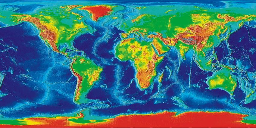
featuresTopographic map of Earth’s crust
• Harry Hess, a
  geologist at
  Princeton,
  developed a
  hypothesis
  proposing that the
  sea floor moves

                       Harry Hess, 1906-1969
◼ Hess proposed that new sea floor is created
at the mid-oceanic ridge by magma seeping
into rifts and cooling
◼ At first glance, this would cause the Earth to
increase in diameter
◼ To address this problem, Hess proposed that
old seafloor sinks back into the mantle at
trenches, maintaining Earth’s diameter◼ Therefore, the sea floor is moving like giant
conveyor belt away from crest of mid-
oceanic ridge, down the flanks of the ridge,
and across the deep ocean basin, to
disappear finally by plunging into a trench
beneath a continent or island arc
◼ Hess’ hypothesis was called sea floor
spreading, because he reasoned that the
ridge crest is the spreading centerOceanic Andesitic
Island Arc trench Mid-oceanic Volcano
(andesitic volcanoes) Ridge Oceanic
trench
Rift valley
Continental Crust
Seafloor Crust
Magma Magma
Magma
Asthenosphere
Hot
Benioff magma
zone Cold seafloor
and mantle rock
Hot magma rising beneath the mid-oceanic ridge causes basaltic volcanism and high
heat flow. Divergence of the sea floor splits open the rift valley and causes shallow-focus
earthquakes (smaller stars on ridge). Sinking of cold, dense rock causes subduction of
old seafloor at trenches, producing Benioff zones of deep-focus earthquakes (larger stars
on subducting seafloor) and andesitic volcanism.◼ What was the driving force for seafloor
spreading?
• Hess proposed that convection currents of
magma in the asthenosphere
◼ A convection current is a very slow circulation
of a fluid substance driven by differences in
temperature and density within that substance
◼ The asthenosphere is a weak zone within the
upper mantle, underlying the lithosphere and
consisting of hot, plastic magma that acts as a
lubricating layer for tectonic plate movementRift valley at
ridge crest
Trench Trench
Cold Hot
water water
Hess proposed that convection extended
throughout the mantle. (Scale of ridge
and trenches is exaggerated.)
Convection currents in a pot of water.Seismic tomography of sinking
magma tomography
Seismic in Earth’s mantle
of rising magma
in Earth’s mantle• This hypothesis helped explain data
about many features of sea floor
◼ Mid-oceanic ridge
• The ridge crest is 1000s km higher than the
surrounding abyssal plain
• High heat flow is measured along the mid-oceanic
ridge
• Fresh basalt is found at the ridge crest
• Frequent, shallow earthquakes are recorded along
the mid-oceanic ridge• Hess suggested that if convection drives sea-floor spreading, then hot mantle rock must be rising under the mid-oceanic ridge • As hot rock continues to rise, the circulation pattern splits and diverges away from ridge near the lithosphere • Friction of the hot, molten rock moving horizontally away from the ridge on each side creates tension at the ridge crest • The tension is released by cracking open of the oceanic crust to form the rift valley and causing its associated shallow-focus earthquakes
◼   Oceanic trenches
     • Hot mantle rock moving horizontally drags the
       overlying sea floor along with it
     • As the seafloor rock moves away from the mid-
       oceanic ridge, it cools and becomes denser
     • Eventually, the sea floor becomes cold and dense
       enough to sink back into the mantle, where it is
       re-melted
• The downward plunge of the seafloor rock produces oceanic trenches • The interaction between plunging crust and floating crust produces [Benioff] zones of earthquakes associated with trenches • This interaction also produces andesitic volcanism, which forms volcanoes either in island arcs or on the edge of a continent
• Seafloor spreading was verified by deep
  sea research, with an added bonus
  ◼   Deep-sea drilling revealed marine magnetic
      anomalies in the seafloor
  ◼   The magnetic record on the sea floor
      contained banding patterns of magnetic
      polarity reversals
Positive magnetic
• The bands were
Negative
anomaly magnetic
Magnetometer anomaly
parallel to the mid-
record of
magnetic field
strength
oceanic ridge crest,
Rift valley at ridge crest
and they matched with
Oceanic
crust
the record of magnetic
A
Positive magnetic anomaly
reversals recorded in Negative magnetic anomaly
Rift valley at ridge crest
lava flows on
continents
10 Kilometers
B
Marine magnetic anomalies. (A) The red line
shows positive and negative anomalies as
recorded by a magnetometer towed behind a
ship. In the cross section of oceanic crust,
positive anomalies are drawn as black bars
and negative anomalies are drawn as white
bars. (B) Perspective view of magnetic
anomalies shows that they are parallel to the
rift valley and symmetric about the ridge crest.
[Adapted from Plummer and McGeary, 1991.]• This new evidence enabled scientists
to:
1) measure the rate of sea-floor motion
2) predict and determine the age of the sea
floor• The hypotheses of Wegener and Hess
were unified into the theory of plate
tectonics
◼ The surface of Earth consists of large,
mobile slabs of rock called plates
◼ There are 10 major plates, 12 minor plates,
and numerous microplates
• Plates are part of the rigid outer shell of Earth,
called the lithosphere◼ Below the lithosphere is the
asthenosphere
• The asthenosphere is a zone of about 100 km
thickness, consisting of hot, plastic magma
[=semi-molten rock]
• The asthenosphere acts like a lubricating layer
under the lithosphere and allows plate movement0 45 90 135 180 135 90 45
Plate
boundary
uncertain
60 60
Eurasian Plate
North American
Plate
Hi m
ala
ya s Caribbean
30 30
Philippine Sea Plate
Arabian Plate Plate
Indian Cocos
Plate Plate
0 African 0
Plate Pacific Plate
An
de
s Moun tains
Diffuse
plate
Australian Nazca
30 boundary Plate South 30
Plate American
Plate
60 Antarctic Plate 60
Scotia
Scotia
Plate
Plate
0 45 90 135 180 135 90 45
The major tectonic plates of the world. The western edge of the map repeats the eastern edge so that all
plates can be shown unbroken. Spreading centers are in red, and converging boundaries are indicate d by
heavy lines with triangles. (Modified from W. Hamilton (1977, U.S. Geological Survey) and National Geographic Society (1995).• The theory of plate tectonics suggests that
there are three types of plate boundaries
1. Diverging boundaries
• Diverging boundaries are where plates move apart
• They form rift zones where new crust is made2. Converging boundaries
• Converging boundaries are where plates collide
• They form subduction zones, where trenches are
produced, or thrust zones, where mountains are
formed3. Transform boundaries
• Transform boundaries are where plates slide
past each other in opposite directionsEmpirical data supporting plate tectonics theory
Oceanic Crust Continental Crust
Crust Thickness 7 km 30-50 km
[Plate Lithosphere 70 km 125 km]
Thickness
Density of Rock 3.0 g/cm3 2.7 g/cm3
Probable Composition Basalt Granite
Age (i.e., Oldest) ~190 Mybp 3.964 BybpYou can also read