The Psyche Topography and Geomorphology Investigation - ELIB-DLR
←
→
Page content transcription
If your browser does not render page correctly, please read the page content below
Space Science Reviews              (2022) 218:7
https://doi.org/10.1007/s11214-022-00874-7

The Psyche Topography and Geomorphology Investigation

Ralf Jaumann1 · James F. Bell III2 · Carol A. Polanskey3 · Carol A. Raymond3 ·
Erik Aspaugh4 · David Bercovici5 · Bruce R. Bills3 · Richard Binzel6 · William Bottke7 ·
John M. Christoph2 · Simone Marchi7 · Alicia Neesemann1 · Katharina Otto8 ·
Ryan S. Park3 · Frank Preusker8 · Thomas Roatsch8 · David A. Williams2 ·
Mark A. Wieczorek9 · Maria T. Zuber6

Received: 7 June 2021 / Accepted: 15 February 2022
© The Author(s) 2022, corrected publication 2022

Abstract
Detailed mapping of topography is crucial for the understanding of processes shaping the
surfaces of planetary bodies. In particular, stereoscopic imagery makes a major contribution
to topographic mapping and especially supports the geologic characterization of planetary
surfaces. Image data provide the basis for extensive studies of the surface structure and mor-
phology on local, regional and global scales using photogeologic information from images,
the topographic information from stereo-derived digital terrain models and co-registered
spectral terrain information from color images. The objective of the Psyche topography and
geomorphology investigation is to derive the detailed shape of (16) Psyche to generate or-
thorectified image mosaics, which are needed to study the asteroids’ landforms, interior
structure, and the processes that have modified the surface over geologic time. In this paper
we describe our approaches for producing shape models, and our plans for acquiring re-
quested image data to quantify the expected accuracy of the results. Multi-angle images ob-
tained by Psyche’s camera will be used to create topographic models with about 15 m/pixel
horizontal resolution and better than 10 m height accuracy on a global scale. This is slightly
better as global imaging obtained during the Dawn mission, however, both missions yield
resolutions of a few m/pixel locally. Two different techniques, stereophotogrammetry and
stereophotoclinometry, are used to model the shape; these models will be merged with the
gravity fields obtained by the Psyche spacecraft to produce geodetically controlled topo-
graphic models. The resulting digital topography models, together with the gravity data,
will reveal the tectonic, volcanic, impact, and gradational history of Psyche, and enable
co-registration of data sets to determine Psyche’s geologic history.

Keywords Psyche · Asteroide topograph · Asteroide geology · Mapping strategy

1 Introduction/Background
The objectives of the Psyche mission are to investigate the processes and conditions that
formed the asteroid Psyche that also affected its subsequent geologic evolution. The shape

The NASA Psyche Mission: Science Instruments and Investigations
Edited by James F. Bell III, Carol Polanskey, and Lindy Elkins-Tanton
Extended author information available on the last page of the article
7    Page 2 of 30                                                              R. Jaumann et al.

and detailed topography of asteroid Psyche may have recorded much of its history, including
differentiation, possible magmatism, convective motions and bombardment history, as well
as the nature of surface alteration by gradational (weathering, erosion and depositional)
processes.
    Asteroid Psyche’s high density of 3.88 ± 0.25 g/cm3 (Siltala and Granvik 2021) suggests
an unexplored surface mineralogy partly composed of metallic compounds with specific re-
action to geological processes (for a review, see Elkins-Tanton et al. 2020). The reconstruc-
tion of the shape, along with the gravity fields, will allow inferences on the internal structure,
while basins, crater shapes, lineaments, ridges, graben, and volcanic constructs will provide
a framework for interpreting the images and spectral data to determine the geologic history
of Psyche. By exploring the formation and evolution of Psyche, we glean insights into the
nature of other objects in the asteroid belt and possibly the interiors of differentiated objects
that coalesced to form the terrestrial planets.
    Image data provide the basis for extensive studies of the surface structure and mor-
phology on local, regional, and global scales. This is accomplished by extracting geomor-
phologic information from images, topographic information as derived from digital terrain
models (DTMs), and spectral information from color images (i.e. Jaumann et al. 2012).
Knowledge of the magnitudes as well as the directions of slopes is needed to understand
such quantities as the depths of craters and depressions, the viscous response of materi-
als to stress, the heights of mountains and thus the volumes of geological features. Direct
topographical measurements are also needed to determine whether more than one phase of
deformation (Fossen et al. 2019) is present and the degree of erosion of the surface from me-
teoritic and thermal processes (i.e. Delbo et al. 2014). Additionally, for asteroids like Psyche
with a surface gravity less than 1% that of the Earth, and much lower interior stresses, these
topographic expressions are likely to be more global in scale and can constrain the aster-
oid’s internal structure, formation and geology. Deeply excavating craters can thus probe
the global properties (e.g. Jutzi et al. 2013), as can global faults (Buczkowski et al. 2012)
and antipodal units.
    Determining physical surface properties also provides geologic context. Identification of
geologic units in terms of morphology, structure, age and compositional heterogeneities de-
pends on local relief and the direction of slopes. Relationships of different geologic units
define stratigraphic sequences, which are used to model the processes that formed specific
surface features. Topographic measurements are thus crucial for these investigations and are
also used to refine the geodetic control network needed for gravimetric investigations (Ray-
mond et al. 2011; Park et al. 2016). A comprehensive evaluation of the data from the Psyche
Multispectral Imagers, based on the image-derived topographic image base maps, will en-
able combined structural/compositional investigations using camera and spectrometers.
    Like Dawn, Psyche is principally a systematic mapping mission to a previously unex-
plored object. Thus, there are no requirements for targeted observations; nor can the shape
and gravity field be sufficiently characterized until arrival. As demonstrated by Dawn close-
orbiting experience (Rayman and Mase 2014; Parcher and Whiffen 2011; and Kennedy et al.
2013) a large, unmapped asteroid requires a recursive approach in which science observa-
tions in one orbit enable refinement of the gravity field and shape model so as to plan the
transfer to the next lower orbit. Psyche will execute a series of four progressively lower cir-
cular orbits and spend 20 months in orbit observing Psyche simultaneously with all science
instruments. Topographic maps are produced using the stereo photogrammetry (SPG) and
stereo photoclinometry (SPC) techniques mainly developed by the Dawn mission (Raymond
et al. 2011; Polanskey et al. 2012; Jaumann et al. 2012; Preusker et al. 2016).
The Psyche Topography and Geomorphology Investigation                         Page 3 of 30     7

2 Current Geomorphological Knowledge

2.1 Landforms

Asteroid Psyche is suggested to have at least one large impact crater near its south pole, sim-
ilar to that found on (4) Vesta (Shepard et al. 2017; Viikinkoski et al. 2018). In addition, the
shape of Psyche as modelled by Ferrais et al. (2020) indicate deviations from an ellipsoid,
interpreted as three large depressions along its equator. According to the model of Ferrais
et al. (2020) the flatness and density of Psyche are compatible with a formation at hydro-
static equilibrium with a shorter rotation period that may have later slowed down by impact
events. With its low gravity, the interior stresses inside of Psyche are much less than 1 kbar,
comparable the stress conditions found a few 100 meters below the surface of the Earth;
a solid Psyche can maintain a substantial disequilibrium shape attributed to its formation.
    Mostly due to the two large south polar impacts Veneneia and Rheasilvia, the surface
of Vesta exhibits extended undulated landforms (Thomas et al. 1997; Jaumann et al. 2012;
Schenk et al. 2012). The ratio of the amplitude of surface relief to the radius of Vesta is
∼ 15%, meaning that topography locally adds or subtracts 1/5th of the body’s average ra-
dius! Compared to a ∼ 1% ratio for the Moon and Mars steep slopes > 10◦ up to 30◦ are
much more common on Vesta. And like Vesta, Psyche has a rapid rotation (4.1 hr), which
means that mega-crater formation happens in the presence of Coriolis forces that could dra-
matically influence the final topography (Jutzi and Asphaug 2011; Otto et al. 2016). Also
Pallas records a violent collisional history, with numerous craters larger than 30 km in di-
ameter populating its surface and two large impact basins which might consider Pallas a
preview for Psyche although the surface strength of Psyche is most likely much higher than
Pallas (Marsset et al. 2020).
    Considering the expected large impact craters on Psyche, the ratio of the amplitude of
surface relief to radius is likely to be at least 10% also resulting in steep slopes, depending
upon how much silicate regolith is contained on the surface. Steep slopes will also encour-
age gravitationally driven mass wasting, which is a significant landscape forming and ero-
sive processes on Vesta (Otto et al. 2013; Krohn et al. 2014). Next to granular landslides
and impact ejecta related flow-like features, Vesta also exhibits pervasive slumping of more
competent material along the crater rim of the large impact basin Rheasilvia. Given the
potentially high strength of Psyche’s crust and the steep slopes, large scale mass-wasting in-
cluding slumping can therefore be expected. Therefore, Psyche is expected to exhibit Vesta
like asymmetric craters formed by impacts on steep slopes, which results in a sharp ups-
lope crater rim, and a muted downslope crater rim because of preferential accumulation of
ejecta downslope (Jaumann et al. 2012; Krohn et al. 2014). However, the shapes of craters
on Psyche may differ significantly from what we know from Vesta due to a high content
of metal and differing impact velocities (Libourel et al. 2019; Marchi et al. 2019). The de-
pendence of crater collapse on target strength has already been shown for silicate Vesta and
ice-rich Ceres (Schenk et al. 2021). Larger craters on Psyche are also expected to undergo
gravity-driven collapse at the end of the excavation phase but on high strength metallic bod-
ies, collapse might be suppressed (Elkins-Tanton et al. 2020). In addition, the distribution
of silicates on Psyche will therefore result in different stratifications of the near-surface that
are exposed by impact cratering (Elkins-Tanton et al. 2020). Extensional features caused by
the pressure response of large impacts could be produced, such as the Divalia and Saturnalia
Fossae observed on Vesta (Jaumann et al. 2012; Buczkowski et al. 2012). In this context
steep hills and elongated depressions would provide an environment for mass wasting and
collapse. Psyche’s higher density compared to Vesta, and thus its metal fraction, could yield
7    Page 4 of 30                                                             R. Jaumann et al.

crater morphologies with steeper slopes. More competent material could result in ejecta
dominated by large blocks and less sorting of regolith particles. From more details about
putative impact structure on Psyche see Marchi et al. (2022) this issue.
   Although impact craters are expected to dominate Psyche’s morphology, a large impact
basin and/or large impact crater could cause global features such as ancient compressional
blocks resulting in mountainous complexes like Vestalia Terra on Vesta, possibly includ-
ing dike-like features (Buczkowski et al. 2014). Johnson et al. (2020) describes a process
where core material intrudes into the overlying rocky mantle or possibly even erupts onto
the surface as ferrovolcanism eruptions that may produce volcanic landforms on Psyche.

2.2 Surface Alteration

The evidence of a thick regolith layer on Vesta (Jaumann et al. 2012; Denevi et al. 2016), the
Moon, and all planetary airless bodies with a solid surface prove the effectiveness of weath-
ering by solar wind, meteoroid, asteroid, and cometary bombardment. Primary planetary
crusts are covered by globally and regionally distributed ejecta. Craters are eroded by bom-
bardment and covered by subsequent ejecta of larger impacts resulting in impact-induced
resurfacing by the formation of multiple regolith layers. Steep slopes and failure support
mass wasting and scarp formation yielding additional resurfacing by landslides.
    However, regolith on Psyche will be subject to a possible metallic component mixed
into silicate particles. In addition to the metallic component originating from Psyche’s bulk
composition, metal-bearing silicate, sulfide, and oxide minerals are chemically reduced by
space weathering processes including solar wind ion irradiation (Pieters et al. 2000) and
micrometeoroid impact (Sasaki et al. 2001), forming metallic iron particles at a variety of
length scales up to ∼ 10 microns (Noguchi et al. 2014; Matsumoto et al. 2020). Thus, com-
ponents of different density, size and sorting are predicted to dominate the regolith resulting
in complex block-dominated mass wasting features (Kleinhans et al. 2011). The angle of
repose of freely moving grains is higher on smaller bodies: lesser gravity allows grains to
pile at higher angles before slipping downslope. Ermakov et al. (2019) finds that the angle
of repose on Vesta and Ceres is around 34◦ , while on the Moon and Mars it is closer to 30◦ ,
and on the Earth lower still. This means that where regolith is formed on asteroids, we can
predict it to pile into steeper slopes assuming the same regolith particle shapes and sizes.
Thus, with Psyche’s even lower gravity, its angle of repose may be higher than that of Vesta.
    Importantly, it is not clear if metal forms a regolith at all. Regolith on Psyche may be
mainly rocky material. If a metallic regolith exists, grains might be less regular, and therefore
more interlocking capable of forming even steeper slopes? Or would it be mainly smooth
tektites formed by impacts into metal, and therefore slipperier and forming shallower slopes?
If metal and silicate particles are mixed the regolith become more complex with respect to
its physical properties. Haack et al. (2020) mixed spherical and angular particles and mea-
sured the tensile strength of different mixing ratios (proxy for the steepness of the slopes).
They found that the strength of spherical and angular particle mixtures is dominated by
the stronger component (angular particles) and that it varies up to two orders of magnitude
between purely spherical and purely angular particles. It is also possible that larger agglu-
tinates will form by impact gluing together silicate particles by molten metal increasing
the grain size of the regolith. The grain sizes of regolith on asteroids can be predicted in-
cluding thermal, polarimetric, photometric, and spectroscopic data (e.g. Hicks et al. 2014;
Hiroi et al. 1994). Capria et al. (2014) used VIR thermal data to estimate the thermal iner-
tia of Vesta’s surface, and thereby estimate the surface particle size range. They conclude
that Vesta has a regolith with grain sizes and properties similar to that of the Moon, with a
The Psyche Topography and Geomorphology Investigation                         Page 5 of 30     7

size range from microscopic to multi-meter blocks. Thermal inertia estimates of Psyche are
133 or 114 J m−2 s−0.5 K−1 (Matter et al. 2013), which is among the highest thermal inertia
values measured for an asteroid of this size, supporting evidence of a metal-rich surface for
Psyche. However, a study by Landsman et al. (2018) reported thermal inertia values that
were representative of a silicate regolith.
    Considering a metallic substrate on Psyche will additionally cause fracture from impact
shock resulting in large-scale displaced bedrock units and metallic blocks in the meters
to tens-of-meters range. However, it is unclear whether blocks in this size range remain
angular and intact or the heat transfer will partially melt the metals forming breccias? It is
also unclear what the smallest possible block originating from impact shock without melting
may be in metal, whether meter-scale boulders, tens-of-cm-scale cobbles, cm-scale gravel,
or smaller. Investigations into shock darkening e.g. Moreau et al. (2019) have found that
even mm-scale differences in shock impedance, as in a regolith with mixed metallic and
non-metallic particles, are enough to drive significant local heterogeneity in shock pressure
and temperature, resulting in partial melting of the metallic fraction. Whether similar effects
occur at cm-scales or larger is unclear.
    Impact experiments on metal yield a variety of metal ejecta fragments (Marchi et al.
2019), with preliminary characterization indicating a wide range of alteration textures from
fully-melted microtektites to shock-fractured shards preserving pre-impact microstructure
(Christoph et al. 2021). Therefore mm- and cm-sized metal impact melted spherules and
impact shards could interact with silicate particles. Shaking from impacts and sliding may
sort this material. Impact experiments on metal yield a variety of metal microtektites (Marchi
et al. 2019). Therefore mm- and cm-sized metal tektite spheres may interact with silicate
particles. Shaking from impacts and sliding may sort this material. The interactions of metal
and silicate particles, thus, are possibly complex and difficult to predict. Variations in surface
roughness, mixtures of minerals or meteorite types, and optical properties like phase angle
and polarization of collected asteroid spectral data (i.e., Britt and Pieters 1988; Cloutis et al.
1990a,b; Lupishko and Belskaya 1989; De Sanctis et al. 2012, 2013; Stephan et al. 2014;
Figeri et al. 2015) also expect Psyche having a surface that is dominated by relatively fine-
grained (20–50 µm in size) iron-nickel metal, but with a significant component of low-Fe,
low-Ca orthopyroxene. The brittle-ductile transition for metal will also affect the outcome
of cratering on Psyche because the strength of the metal increases for lower temperatures
(Marchi et al. 2020, 2022 this issue).

3 Topography of Asteroids

Asteroids can be highly irregular planetary bodies, with some showing an order of magni-
tude higher topography to radius ratio than planets or moons. Detailed mapping of topog-
raphy is central to understanding of processes shaping surfaces. Topography is fundamental
for studying their surfaces and interiors, yielding information on landforms, slopes and lo-
cal surface properties such as roughness as well as internal density variations. The shape of
Psyche is essential to properly invert gravity data of asteroids and derive a robust modeled
interior structure. Detailed impact crater shapes, slopes, as well as the form of any surface
feature provides fundamental morphometric constraints on geological processes that have
operated on surfaces (Jaumann et al. 2012).
   On asteroids, the shape of craters, possible surface deflection by mass loads, and mass
wasting and regolith movement and front shapes, provide constraints on rheology over time
and depth. Topography is obtained by a combined solution using camera views at various
7    Page 6 of 30                                                              R. Jaumann et al.

angles and multiple views of each surface element. Camera-derived surface heights enable
the development of regional grids for quantitative studies of surface processes. Stereo infor-
mation, combined with precise gravity field models, also provides a geodetic control grid at
sufficient scale, in which to co-locate other data types at absolute positions on the bodies.
Both the imaging and the gravity datasets can provide information needed to resolve inter-
nal heterogeneity. At shorter scales and at lowest altitudes the thickness of the crust can be
deduced. Geomorphologic studies require slope information at a few percent at the scale of
the smallest resolved craters. Optical observation contributes to the topography objective via
stereo imaging, from which digital terrain models at high spatial resolution (on the order of
the camera pixel size) are derived (i.e. Jaumann et al. 2007; Raymond et al. 2011; Preusker
et al. 2012; Gwinner et al. 2016). These digital terrain models provide fundamental insight
into geological processes and help constrain studies of the formation and evolution of the
crust.
    The combination of gravity, topography, and surface composition data is key to modeling
the entire structure and composition of a body. Image data provide the basis for extensive
studies of the surface structure and morphology on local, regional, and global scales us-
ing the photogeological information, the topographic information from the derived digital
terrain model, spectral information from color images, and spectral reflectance data. Knowl-
edge of the magnitudes as well as the directions of slopes is needed to understand such
quantities as the viscosities of flow features and lavas, and hence their possible composition,
the volumes of constructs and flows, the depths of craters/depressions, and the heights of
mountains.
    Direct topographical measurements are also needed to determine whether polyphase de-
formation (i.e. Fossen et al. 2019) is present and the degree of erosion of the surface. Identifi-
cation of geologic units in terms of structure, age and compositional heterogeneities depends
on local relief and the direction of slopes. Relationships of different geologic units define
stratigraphic sequences, which are used to model the processes that formed specific surfaces.
Topographic measurements are crucial for these investigations and are also used to refine the
geodetic control network needed for gravimetric investigations. Topography of small bodies
improved the science output of the orbiting missions Dawn, Rosetta, Hayabusa 2 and Osiris-
REx yielding detailed insight into the shape and structure of Vesta, Ceres, Ryugu and Bennu
(i.e. Jaumann et al. 2012; Preusker et al. 2012, 2016; Fu et al. 2017; Watanabe et al. 2019;
Sugita et al. 2019; Lauretta et al. 2019) and supported landing and sampling (i.e. Preusker
et al. 2019; Scholten et al. 2019; Park et al. 2019).

4 Methodology

Imaging data have been used to generate topography data set in planetary exploration. Two
approaches will be used to quantify the topography of the surface of Psyche; these are stereo-
photogrammetry (SPG) and stereo-photoclinometry (SPC), which also uses a shape-from-
shading approach. Both techniques are applied to multiple optically observed images of the
same region (Jaumann et al. 2007; Gaskell et al. 2008; Raymond et al. 2011). Photogram-
metry, the geometrical analysis of stereo pairs of optical images, has provided much of our
knowledge about the quantitative topography of Earth and other planets. Photoclinometry
is an alternative approach that can be applied to unpaired images and can achieve single-
pixel resolution, because it is based on interpreting brightness (shading) variations in slopes
rather than measuring geometrical parallaxes. It is more model-dependent and requires ad-
ditional data for scaling and absolute referencing. The Psyche team will also use a refined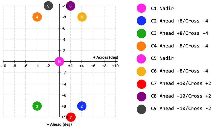
The Psyche Topography and Geomorphology Investigation                       Page 7 of 30     7

photoclinometric technique (photoclinometry by deformation, or PCD) that can iteratively
solve for both the slopes and albedo variations, thus reducing the model-dependence in the
photoclinometric solution (Raymond et al. 2011).

4.1 Stereophotogrammetric Mapping (SPG)

Photogrammetric processing will derive three-dimensional models of Psyche’s surfaces and
ortho-rectified images (orthoimages). The raw camera data received from the spacecraft are
sorted, adjusted by acquisition times, decompressed and radiometrically calibrated. Camera
ancillary data (geometric distortion model), as well as other external geometric information
such as orbit and attitude data. A variety of panchromatic and color three-dimensional prod-
ucts can be achieved by means of stereo-photogrammetric processing, i.e., Digital Terrain
Models (DTMs), multi-spectral orthoimages, image mosaics, and finally various types of
3D-visualizations and cartographic products. DTMs are the main high-level products that
serve as a precise description of Psyche’s topography for science and for ortho-rectification
of image data at high spatial resolution. Considerable experience related to the photogram-
metric processing of planetary data has been gained over more than 15 years from vari-
ous planetary missions (e.g., Jaumann et al. 2007; Scholten et al. 2009; Raymond et al.
2011; Jaumann et al. 2012; Preusker et al. 2015, 2016; Gwinner et al. 2016). The stereo-
photogrammetric derivation of a DTM relies on area-based multi-image matching of two
or more images. From the combination of the resulting tie point coordinates, combined
with the interior camera geometry, and information of the orbit position and pointing, a 3-
dimensional forward ray intersection yields an irregular grid of object points, which is used
to interpolate a final raster DTM. Generally, the quality of DTMs and orthoimages strongly
depends on the accuracy of the orientation data such as the well calibrated interior camera
geometry, the reconstructed position and attitude spacecraft pointing data derived from ra-
dio tracking and optical navigation and combined with results from photogrammetric block
adjustment information.
    The photogrammetric DTM generation process chain (Fig. 1) is embedded in an iterative
procedure. A coarse-to-fine iteration includes photogrammetric block adjustment in order to
improve the initial spacecraft/position, pointing direction, and the alignment of the camera
to the spacecraft. Subsequently, intermediate DTMs are calculated and serve as input for pre-
rectification. Once iterations of all global stereo image dataset have yielded full-resolution
tie point coordinates the final orientation is derived by an overall photogrammetric adjust-
ment of the entire global block yielding the final stereo DTM interpolation.
    Stereo data are pre-rectified to a constant pixel scale in common geometry based on
preliminary orbit and pointing information. With remaining parallaxes, the deviation of the
a priori topography assumption to the true shape of the body can be estimated to enable
linking the pre-rectification geometry to the raw image geometry. Applying a multi-image
matching technique to pre-rectified image allow to derive conjugate points in each of the
stereo observations. The algorithm uses area-based correlations in image pyramids to derive
approximate values for the image coordinates, refine sub-pixel accuracy by least-squares
matching (Gwinner et al. 2009). After multi-image matching, the derived image coordinates
of all stereo observations are transformed back to raw radiometrically corrected data geom-
etry, using the history files generated during the pre-rectification. The accuracy of this back-
transformation is better than one tenth of a pixel (Scholten et al. 2005). Lines of sight as
defined by the image coordinate pair for each stereo observation, the geometric calibration,
and the orientation data, with least-squares adjustment are used for forward ray intersection,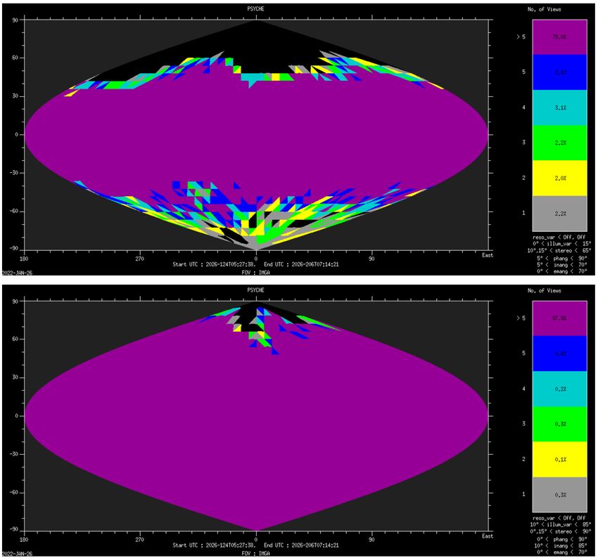
7    Page 8 of 30                                                             R. Jaumann et al.

Fig. 1 Processing line for DTM
generation from stereo data
(Raymond et al. 2011)

resulting in object points defined in body-fixed Cartesian coordinates. Multi-stereo capabil-
ity enables minimization of the influence of occasional gross matching errors, which cannot
be avoided by simple two-image matching.
    Object points are transformed from body-fixed Cartesian coordinates to geographic lati-
tude/longitude/height values based on a three-dimensional reference system. The geographic
latitude/longitude coordinates of all object points from all stereo image sets are transformed
to standard map projections (equidistant projection for equatorial regions up to ±85◦ , stereo-
graphic projection for polar regions). Object points located within a DTM pixel are averaged
and can optionally be combined by different filtering techniques with those within a cho-
sen neighborhood (Gwinner et al. 2009). For regions that lack any object point information,
a final gap-filling algorithm using DTM pyramids with reduced resolution can be applied.
    Ortho-rectification uses ray-tracing of the regular pixel positions of the input radiometri-
cally-corrected pixel matrix with the DTM based on interior camera calibration and exterior
orientation data (Scholten et al. 2005). A 3-D intersection point with the DTM is derived
for each grid point and transformed to the map projection of the output orthoimage with
the same standard projections as for the DTM. For each pixel within a mesh of these trans-
formed grid points, an indirect resampling based on different selectable interpolation meth-
ods is performed within the radiometrically corrected input matrix in order to derive the final
orthoimage grey value. Finally, ortho-rectified color and panchromatic channels, if rectified
to the same map projection and pixel scale, fit to each other with the accuracy provided
by the DTM and the applied orientation data and can be superimposed as co-registered
multi-spectral/multi-phase data sets (Scholten et al. 2005). Ortho-rectified images of differ-
ent orbits are combined to one common image mosaic using image information in overlap-
ping areas for producing seamless transition from image to image by weighted averaging of
overlapping image parts. The geometric relationship between the images to be mosaicked is
considered to be fixed and is defined by each image’s label information comprising nominal
map projection parameters, scale, and the offset of its upper left pixel with respect to the pro-
jection center. Statistics of the density of object points (Gwinner et al. 2009), which might
The Psyche Topography and Geomorphology Investigation                                Page 9 of 30       7

Fig. 2 Example of displacements (red arrows). Identical points are identified in overlapping blocks of Mars
Express HRSC images and corrected by bundle block adjustment (Gwinner et al. 2016)

Fig. 3 HAMO-based SPG-derived global topography of Vesta (e.g. Jaumann et al. 2012; Preusker et al. 2012,
2016) superposed on a hill shade model derived thereof. The map is in equal area Mollweide projection in
the Claudia Double Prime reference system for Vesta (Li 2012)

be affected by compression effects, variable local texture and varying illumination condi-
tions, will allow a quality assessment of the stereo data processing accuracy. Displacements
identified in overlapping images can be corrected by bundle block adjustment (Gwinner
et al. 2016) (Fig. 2).
    Figures 3 and 4 show final DTM products resulting from stereo data of the Dawn and
Mars Express missions.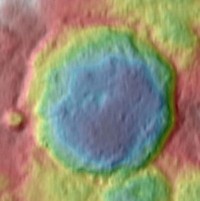
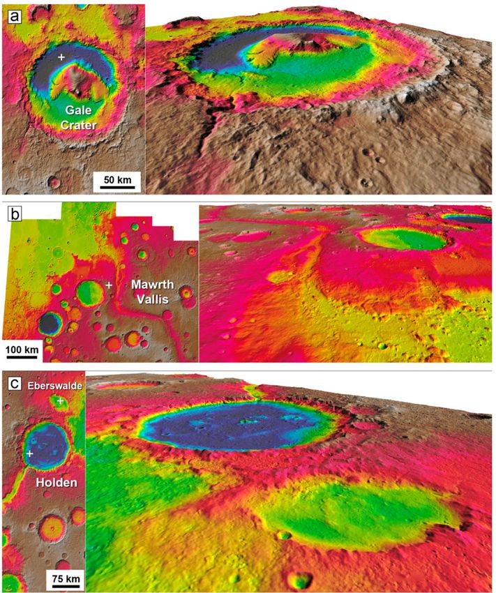
7    Page 10 of 30                                                                        R. Jaumann et al.

Fig. 4 Examples of final DTM products. Mars Express HRSC multi-orbit DTMs of the final four candidate
landing sites of the Curiosity (white crosses centers of proposed ellipses). On the left plan views (norths up);
right-side perspective views; color-code elevations (red = high, blue = low). (a) Gale crater; (b) MawrthVal-
lis; (c) Holden and Eberswalde craters (Gwinner et al. 2016)

4.2 Stereophotoclinometric Mapping (SPC)

Stereophotoclinometry uses orthorectified projections of many images of a surface patch,
observed under differing illumination conditions, to construct a landmark template called
a maplet (Raymond et al. 2011; Park et al. 2019). The slope and albedo at each pixel of
a maplet is determined by least square minimizing the brightness residuals between the
images and illuminated maplet via least square estimation. The slopes are then integrated
to produce a digital terrain map (DTM). Figure 5 shows the topo/albedo maplet constructed
from 62 NEAR images of Eros, re-illuminated and compared with projected image data.
The maplets display the major features of the images and reproduce the brightness variations
well.
   A maplet identified in a large number of images allows determination of its surface lo-
cation very precisely, by averaging down spacecraft position errors and camera pointing
uncertainties, while a large number of maplets in a single image allow refining spacecraft
The Psyche Topography and Geomorphology Investigation                             Page 11 of 30       7

Fig. 5 Illuminated maplet (bottom row) and projected image data (top row) of Dawn stereoscopic data (from
Raymond et al. 2011)

Fig. 6 Auto registration of projected MDIS (MESSENGER) data. Notice that the maplet surface does not
have to be completely within an image to be usable (from Raymond et al. 2011)

position and camera pointing estimates. Figure 5 shows an example from an auto registra-
tion that solves for the spacecraft state of the MESSENGER mission with the ensemble of
existing maplets.
    A maplet ensemble is more powerful than a collection of single maplets. Overlapping
maplets provide a three-dimensional constraint between the body-fixed locations of their
centers. Finally, if the ensemble tiles the entire body, then they can be combined to produce
a global topography model (GTM).
    An initial set of maplets will be constructed from the first images. As Psyche rotates,
a surface feature is seen at varying local sun elevations, allowing to construct the topogra-
phy from the changing illumination. Correlation of re-illuminated maplet images with the
original allow to determine the precise surface position of each maplet to a few tenths of a
pixel (Fig. 6).
    SPC processing (Fig. 7) has been used on small bodies such as asteroids Eros (Thomas
et al. 2002) and Itokawa (Gaskell et al. 2006), and large ones such as Mercury (e.g. Tenthoff
et al. 2020), Vesta (Gaskell 2012), and Ceres (Park et al. 2019). Psyche is comparable with
the Vesta case and as maplets can be located in images at any resolution, illumination and
viewing geometry, they provide excellent navigation tie points as well.
7 Page 12 of 30 R. Jaumann et al.
Fig. 7 SPC processing flow from inputs (left) through principal software functions (middle) to products
(right). The process is iterative within convergence limits (from Raymond et al. 2011)
An extension of the SPC technique is photoclinometry by deformation (PCD) (i.e. Ray-
mond et al. 2011). This is a technique that allows refinement of shape models or DTMs
(“maplets”) derived using other techniques such as stereophotogrammetry and stereophoto-
clinometry described above. The method is applied to a collection of DTMs, typically the
SPC DTMs produced after different orbit altitudes. PCD requires as input the set of DTMs
describing the surface of the body, and accurate geometric information derived by the nav-
igation and further refined with the above-mentioned SPC and stereo techniques: the pole
orientation, the S/C-object vector in the body-fixed frame and the rotation matrix from the
body-fixed frame to the camera frame for each camera image. It also requires input “photo-
metric parameters” allowing calculation of the bi-directional reflectance of the surface; an
albedo map can be taken as input. The free parameters of the methods are the heights of the
vertices of the DTM above the surface, with the DTM being described as a triangular mesh
(“plate model”).
Although it has been successfully applied to the shape model of asteroid Steins (Jorda
et al. 2012) and to DTMs of the asteroid Lutetia (Capanna et al. 2012) observed by the
OSIRIS cameras aboard ROSETTA, PCD is a newly developed method. It is also a CPU
intensive technique. On Dawn, PCD DTMs and derived photometric parameters have been
compared to the products of the stereo and SPC processing pipelines successfully (Raymond
et al. 2011; Konopliv et al. 2011) and are be used as inputs to the geodetic DTM. PCD
DTMs will also help refine the contributions of brightness variations caused by slope-related
surface properties.
4.3 Geodetic-Referenced DTM
The derived models of Psyche’s shape and gravity will be integrated to produce a single com-
bined and internally consistent model of topography and gravity field. The various shape
models will be combined using their covariance matrices and statistical estimates of their
quality. In addition, radiometric tracking data of the Psyche spacecraft will be re-analyzed
using the best gravity model, together with the shape models, for potential improvement of
both the shape and gravity. The analysis will be conducted with the GEODYN geophysi-
cal estimation program (Rowlands et al. 1993; Pavlis et al. 2001) from imaging data, and
Doppler tracking data of various kinds (Zuber et al. 2000, 2022; Neumann et al. 2001). This
combination of approaches and solutions will allow parameters to be derived using com-
plementary techniques, thereby offering a potential improvement for the complete geodeticThe Psyche Topography and Geomorphology Investigation Page 13 of 30 7
Table 1 Requirements for optimal and useable observing geometry for SPG and SPC (see also Polanskey
et al. 2018)
Parameters Optimal conditions Useable
SPG SPC SPG SPC
Illumination Variation < 10◦ 20◦ –70◦ < 15◦ 10◦ –85◦
Stereo Separation 15◦ , 15◦ –65◦ 0◦ , 20◦ –90◦ 15◦ , 10◦ –65◦ 0◦ , 15◦ –90◦
Incidence Angle 10◦ –60◦ 20◦ –70◦ 5◦ –70◦ 10◦ –85◦
Emission Angle < 55◦ 20◦ –50◦ 0◦ –75◦ 0◦ –70◦
Phase Angle 5◦ –90◦ 0◦ –90◦ 5◦ –90◦ 0◦ –90◦
and geophysical model of Psyche. The primary objective of this approach is to obtain the
best overall topography of Psyche relative to an equipotential surface, with a correspond-
ing gravity field for interpretation of Psyche’s interior and dynamics. For more information
about gravity see Zuber et al., this issue.
4.4 Observing Requirements for Image-Derived Topography
For stereo imaging the flight system pointing knowledge (i.e., the estimated orientation of
the S/C reference frame) should be accurate to 1.5 mrad per axis (3 sigma, zero-to-peak),
recorded at least once per second. The Spacecraft System shall provide a resolution of better
than 0.005 mrad per axis in its pointing commands and shall be able to point the mounting
reference of either imaging camera at a ground-prescribed inertial orientation, with an ac-
curacy of better than 4.65 mrad per axis (3 sigma, zero-to-peak). Note: The accuracy is
defined as the total difference between the commanded and actual pointing. Any imaging
target should be tracked with an accuracy of better than 5 microrad/sec per axis (3 sigma,
zero-to-peak). This includes errors due to tracking rate resolution with a rate resolution of
better than 0.25 microrad/sec per axis for tracking rates that it provides to the Flight System.
The Spacecraft System shall provide a rate resolution of better than 0.25 microrad/sec per
axis in its rate commands.
The stereophotogrammetric method just requires overlapping images from different ob-
servation directions. But quality and quantity of the DTM are significantly affected by the
imaging and illumination conditions involved. Psyche’s stereophotogrammetric observation
and illumination requirements are defined based on the experience from stereo processing
of other planetary missions, mainly Dawn (Raymond et al. 2011). In a similar manner, con-
ditions that contribute to better accuracy photoclinometrically-derived heights can also be
defined (Raymond et al. 2011). Table 1 lists the optimal conditions for each technique, as
well as the useable conditions that may not always produce the best height accuracy.
Requirements for SPG, in order of priority:
• the variation of the illumination direction of stereo images should be < 10◦ , to minimize
mis-matching caused by variable illumination. Angles up to 15◦ are useable.
• the angle between stereo images should be > 15◦ and < 65◦ , to provide sufficient vertical
and horizontal accuracy. Angles as small as 10◦ can be used.
• the incidence angle for each image segment should be > 10◦ and < 60◦ , to provide suf-
ficient contrast and to minimize the amount of cast shadow areas. Incidence as low as 5◦
and as high as 70◦ can be used with care.
• the emission angle for each image segment should be < 55◦ , to exclude near-limb image
segments. Emission as high as 70◦ can be used, and7 Page 14 of 30 R. Jaumann et al.
• the phase angle for each image segment should be > 5◦ , to avoid influence from opposi-
tion effect.
Basic requirements for SPC:
• the variation of the illumination should be 20◦ –70◦ (10◦ –85◦ might be useable).
• Nadir image with the emission angle < 20◦ .
• Image in emission angle bins: 20◦ –50◦ (0◦ –70◦ might be usable).
• Image in incidence angle bins: 10◦ –75◦ (85◦ might be usable).
• Phase angle 0◦ –90◦ .
• At least one image with camera azimuth in each of the bins: 0◦ –120◦ , 120◦ –240◦ ,
240◦ –360◦ , with a maximum camera azimuth separation between adjacent azimuth bins
of no larger than 150◦ .
• At least two images separated by solar azimuth angle by no less than 150◦ .
Considering these requirements, it is evident that SPG and SPC techniques are complemen-
tary in exploiting different observing conditions, with some overlap. This fits the Psyche
mission concept, because the observing geometry is such that both techniques can be used
effectively during the mission, as described below
4.5 Imaging Strategy
At Psyche the topographic model will be constructed using data from Orbit B at an alti-
tude of 293 km. Data from other orbits will also be used when appropriate. Psyche’s imag-
ing plans include ∼ 19,720 images in Orbit B (5,916 with the clear filter and a total of
13,804 with the seven color filters), at ∼ 15 m pixel scale, each of which covers an area
of ∼ 600 km2 . Each image in Orbit B will span a range of phase angles, including angles
< 5 degrees. The main phase of multi-angle imaging occurs in the Orbit B phase; multiple
complete global mappings with overlapping images are planned. For Orbit B, two nadir and
seven off-nadir acquisitions are planned, with a minimum phase angle of 30 degrees.
Psyche will orbit for 20 months. Four coast-only science orbits are foreseen reaching
within one body radius in altitude (Fig. 8). Results from each orbit enable final design of, and
navigation into, the successive orbits – a method demonstrated by Dawn at both Vesta and
Ceres. Each science orbit is designed around a particular driving requirement (for A, gravity
for safe navigation to B; for B, topography; for C, gravity science; for D, composition),
leaving margins for the other measurements reaching into orders of magnitude (Table 2;
Figs. 8 and 9). The downlink budget is sufficient. The science team is organized into both
instrument teams and multi-disciplinary working groups supporting requirements definition
and data processing.
Psyche is principally a systematic mapping mission to a previously unvisited body. Thus,
there are no requirements for targeted observations; nor can the shape and gravity field be
characterized sufficiently until arrival. As demonstrated by Dawn (Rayman and Mase 2014;
Parcher and Whiffen 2011; Kennedy et al. 2013), close orbiting of a large, unmapped aster-
oid requires a recursive approach in which science observations in one orbit enable refine-
ment of the gravity field and shape model so as to plan the transfer to the next lower orbit.
A key observation strategy for Psyche is the use of multiple-angle images to derive topogra-
phy for gravity science, and for morphology. This technique perfected by Dawn (Raymond
et al. 2011; Polanskey et al. 2012), avoids the need for a laser altimeter on the spacecraft.
It does require systematic coverage by overlapping, fixed-off-nadir images, which Psyche’s
sequence of long-duration orbits provides in abundance. The major imaging requirements
are: image pixel scale < 20 m at mean altitude < 400 km; imaging ground track with 20%The Psyche Topography and Geomorphology Investigation Page 15 of 30 7
Fig. 8 Psyche science profile uses orbits that progressively improve data quality as knowledge of the gravity
field allows lower altitudes (orbit-transfer durations not shown)
Table 2 Relevant orbit parameters yield coverage, resolution & range needed. R/Rp is the ratio of the Psyche
spacecraft orbit radius to the Psyche body radius
Science orbit Ave. R/Rp Ave. Inclination Phase Cycle Repeat Orbits/repeat Ave. pixel
or phase altitude period duration duration cycles/phase cycle scale (m)
(km) (hr) (days) (days)
Approach 100
Orbit A 704 7.2 32.6 90 55 12.2 4.5 9 35
Transition to Orbit B 18
Orbit B 293 3.5 11.4 90 80+19 9 9 17 15
Transition to Orbit C 23
Orbit C 174 2.5 6.7 89 100 14.5 7 49 9
Transition to Orbit D 138
Orbit D 71 1.7 3.5 160 100 30 3.3 206 4
overlap at equator, for full coverage in one cycle (also achieves gravity coverage require-
ment); beta angle 30–40◦ , fixed or slowly varying; Lighting conditions > 80% of the body
illuminated or ability to complete coverage later, which will be fulfilled during Orbit B.
Science operations start during the approach phase with an initial assessment of Psyche
and its environment using radiometric and optical-image data to estimate spin state, develop
a preliminary shape model, calibrate image exposures, and search for orbiting secondaries.
At an average altitude of 704 km, Orbit A allows global characterization of the body includ-
ing first time gravity data; combining these data with the global imaging coverage obtained7 Page 16 of 30 R. Jaumann et al.
Fig. 9 Resonant Psyche orbits allow superb coverage with routine mapping operations down to Orbit C;
stable retrograde Orbit D yields 70% compositional mapping coverage
in this orbit allows to derive the shape-constrained gravity model. A ground-track repeat ev-
ery 4th cycle would provide complete imaging coverage in a few days. Each cycle generates
a complete map of the illuminated hemisphere estimated to exceed 90% of the body based
on the currently known pole model, using all eight filters, at 35 m/pixel. The resulting maps
and shape model satisfy the geomorphology and color objectives. Figure 9 illustrates the
imaging coverage for one mapping orbit. 61 images cover Psyche from terminator to termi-
nator and at least 10% along-track overlap based on Dawn’s high-fidelity science planning
tools).
Detailed geological mapping using morphological and topographic information enables
identification of the geologic context of surface features. Identification of geologic units in
terms of morphology, structure, age and compositional heterogeneities is enhanced by infor-
mation on local relief and the direction of slopes. Relationships of different geologic units
define stratigraphic sequences, enabling the identification of relative ages and the model-
ing of the processes that formed specific surfaces. Topographic measurements are crucial
for these investigations and are also used to refine the geodetic control network needed for
gravimetric investigations. A comprehensive evaluation of the measurements from the Psy-
che instruments, based on the image-derived topographic base maps, will enable combined
structural/ compositional investigations using the camera and spectrometers.
At Psyche the topographic model will be constructed using data from the Orbit B at
a mean planetocentric radius of 399 km. Data from other orbits will also be used when
appropriate. Psyche’s imaging plans include ∼ 19,720 images in Orbit B (5,916 with the
clear filter and a total of 13,804 with the seven color filters), at ∼ 15 m pixel scale, each
of which covers an area of ∼ 600 km2 . Each image in Orbit B will span a range of phase
angles, including angles < 5 degrees. The main phase of multi-angle imaging occurs in the
Orbit B phase; multiple complete global mappings with overlapping images are planned.
For Orbit B, two nadir and seven off-nadir acquisitions are planned, with a minimum phase
angle of 30 degrees.The Psyche Topography and Geomorphology Investigation Page 17 of 30 7
Fig. 10 Illustration of the Orbit
B ground track for 17 orbits. The
imager footprints for each orbit
are given a different color and lay
down an image swath with
overlapping frames that butts
against, or overlaps, the
neighboring swath
The main topographic mapping data set is obtained in Orbit B. Once the shape models
are developed and validated, we will assess them and merge the information with the gravity
field to produce the ‘best’ DTM that is referenced to the Psyche center-of-mass.
Global mapping with the imager requires 17 orbits over 8.4 days to complete; the image
footprints relative to the ground-track are shown in Fig. 10. The plans for Orbit B include
seven off-nadir global mapping cycles and two nadir mappings; each off-nadir global map-
ping is done at a fixed attitude. The off-nadir angles were chosen such that both techniques
will get adequate coverage. The viewing geometry is shown graphically in Fig. 11. Coverage
plots for stereo, are shown in Fig. 9, which also illustrates the fact that most data that respect
the stereo illumination variation conditions have a very narrow range of illumination, < 5◦
(bottom panel), which is a natural consequence of the polar sun-synchronous orbit.
In Fig. 12 the stereo coverage plots for SPG and SPC in Orbit B are shown, illustrating
the excellent coverage with many useable data. Combining both data set will result in the
required stereo coverage of 80% which meet the mission requirements.
In addition, the combination of SPG and SPC improves the topographic resolution sig-
nificantly (Fig. 13) as demonstrated by Dawn results of Ceres (Neesemann et al. 2022).
Topographic maps are produced using the stereo photogrammetry (SPG) and stereo pho-
toclinometry (SPC) techniques developed by Dawn [Raymond et al. 2011; Polanskey et al.
2012]; The topography model from clear-filter images taken from multiple view angles using
one imager at a time. The spacecraft is nadir-pointed for the first and fifth mapping cycles;
and at a fixed off-nadir attitude for the rest. Each mapping cycle uses one fixed off-nadir
angle. The set of angles for the series optimizes among multiple factors: stereo separation
between image pairs (≥ 15◦ ); and incidence, emission, and phase angles. Four ground-track
repeat cycles, taking 33.6 d total in Orbit B, are required to meet the topography objective;
five additional cycles are added for margin, driving the science portion of Orbit B to 80 d
total. The spacecraft ground track provides uniform coverage with 20% overlaps between
imaging swaths. The lighting conditions and data budget allow 99% of the surface to be
mapped in Orbit B. In order to verify the coverage, the received images will be georectified
based on the preliminary shape model and mosaicked immediately after each download to
support operations planning (Fig. 14).7 Page 18 of 30 R. Jaumann et al. Fig. 11 Illustration of the off nadir viewing geometry as referenced to spacecraft coordinates for the nine global mapping cycles (Polanskey et al. 2022). For a polar orbit, constant illumination is in the “Ahead” direction, while maximum illumination variation is achieved in the “Cross” direction. The angles in the Cross direction are maximized within the constraints of keeping on the body and achieving proper incidence and emission angles 5 Data Products The following high-level products will be produced: 1. local, regional, and global Digital Terrain Models (DTMs) 2. local, regional, and global clear filter mosaics 3. local, regional, and global color mosaics Figure 15 shows the tiling scheme for quadrangle mapping used for the Dawn mission. The Psyche coordinate system will be defined in two steps. In close cooperation with the IAU, a tiny crater near the equator will be selected to define the longitude system. Next, the rotation axis and period are determined during the photogrammetric processing of the stereo images. Together these will define the coordinate system. The east longitude system will be used and the thematic convention for naming craters and other features will be defined in close cooperation with the IAU. The Psyche topographic atlas will be produced in a scale of 1:250,000 or 1:500,000 and will consist of 15 tiles that conform to the quadrangle scheme. This tiling schema was recently used for the Saturnian satellites like Enceladus and Vesta and Ceres (Roatsch et al. 2012, 2013, 2016). Detailed geological mapping using morphological and topographic information enables identification of the geologic context of surface features. Identification of geologic units in terms of morphology, structure, age and compositional heterogeneities is enhanced by infor- mation on local relief and the direction of slopes. Relationships of different geologic units define stratigraphic sequences, enabling the identification of relative ages and the model- ing of the processes that formed specific surfaces. Topographic measurements are crucial for these investigations and are also used to refine the geodetic control network needed for
The Psyche Topography and Geomorphology Investigation                                Page 19 of 30        7

Fig. 12 In Orbit B, SPG coverage meets the useable stereo conditions for incidence angle up to 70◦ (top) and
resolutions of 10 m/pixel − −20 m/pixel. The bottom plot shows the coverage for SPC in Orbit B with the
same resolution. The colors indicate the number of independent datums in each .25◦ bin that collectively meet
the criteria outlined in Table 1. The area covered at a given number of views is indicated by the percentage
number in the legend

gravimetric investigations. A comprehensive evaluation of the measurements from the Psy-
che instruments, based on the image-derived topographic base maps, will enable combined
structural/compositional investigations using the camera and spectrometers
    A geologic mapping campaign for asteroid Psyche will be performed during the approx-
imately two-year (21 month) nominal mission which will result in a global geologic map
of Psyche at a map scale of 1:500,000. This map scale is based on the size of Psyche (ge-
ometric mean diameter of 186 km). However, given the Orbit B image spatial resolution of
∼ 15 m/pixel, the digital geologic mapping of Psyche can be done at a map scale as high
as 1:60,000. Depending upon the variety and types of surface features discovered on Psy-
che, additional regional/local geologic maps as needed/justified by the geology of Psyche
will be produced, in which cartographic image maps and DTMs are used as our mapping
bases. As was done with Vesta and Ceres, geologic mapping will be done digitally using
ArcGIS™ software and in consultation with mapping specialists from the U.S. Geological
Survey, using community standards (i.e., Skinner et al. 2018).
7 Page 20 of 30 R. Jaumann et al. Fig. 13 Topography of Azacca impact crater on Ceres based on Dawn Framing Camera (FC) observations. (a) The SPG DTM as derived from HAMO data. (b) FC HAMO and Juling 1 orbit frames bundle adjusted and photometric corrected frames SPG processed, followed by SPC processing. This combination allows topographic resolutions as of the HAMO input frames (∼ 136–140 m/pixel). (c, d, e) Show subsets of the central peak and the topographic cross section illustrate the improvement of the SPG and SPC combination Geological mapping of a new planetary object with a totally different surface will arise new issues. Like that used for asteroid (4) Vesta on the Dawn mission surface features will be identified during approach and refined during the first orbital phase (Russell et al. 2015). Based on modeled processes of solidification possible for a stripped, molten metal core the following developed hypotheses for features are expected on Psyche’s surface (see also Elkins-Tanton et al. 2020): • Scarps, perhaps on the order of 10 km tall, from contraction of the body. • Sulfur-rich lava flows from the original solidification and liquid expulsion. • Craters of all sizes and perhaps with different morphologies depending on whether they occurred on the warm or cold side of Psyche. • Slabs, probably on the order of 100 km scale, of achondritic original mantle material from the Psyche parent body that fell back onto the surface during stripping. • Exogenic chondritic silicate deposits delivered by impactors. At present it is unclear how these and other features will look on a metallic object. For example, one might expect a harder metallic surface to be more resistant to the effects of space weathering, such that the surface could have less regolith than silicate objects have. We will follow standard best geological mapping practices to define and characterize the surface into geologic units based on physical attributes (morphology, albedo, color, texture, contact relations with neighboring units and mainly topography), and then work to interpret these features in terms of all the possible geologic processes that might produce them (e.g. Jaumann et al. 2012; Buczkowski et al. 2016). As the spacecraft enters lower orbits and spatial resolution of images improve, it is likely (as we found at Vesta) that one or more hypotheses regarding formation processes for some geologic units can be eliminated (e.g. Jaumann et al. 2012; Buczkowski et al. 2016). This would improve our understanding of the geology of Psyche and enable us to derive its geologic history. Hypothetical surface
You can also read