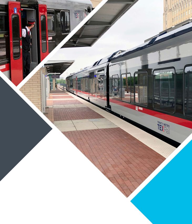
TEXRail Extension
Environmental Assessment

November 1, 2021
←
→
Page content transcription
If your browser does not render page correctly, please read the page content below
TEXRail Extension Environmental Assessment November 1, 2021
ENVIRONMENTAL ASSESSMENT
                                                for
                                   TEXRAIL EXTENSION PROJECT
                                           Prepared by:

                                Federal Transit Administration (FTA)
                                                 and
                                           Trinity Metro

_______________________________________                                ___________________
Don Koski                                                              Date of Approval
Acting Regional Administrator
Federal Transit Administration, Region 6

_______________________________________                                ___________________
Chad Edwards                                                           Date of Approval
Vice President of Planning & Development
Trinity Metro

Project Contact Information:
John Tipton, P.E.
Trinity Metro
801 Cherry Street, Suite 850
Fort Worth, Texas 76102
817‐215‐8629
Email: John.Tipton@ridetm.org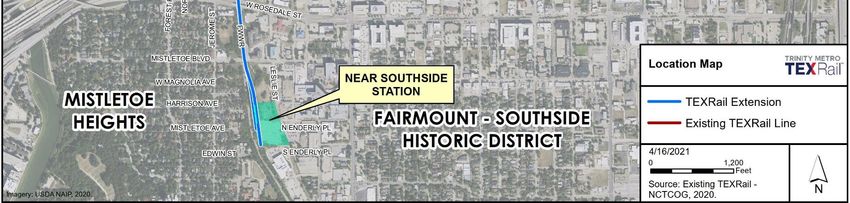
This page intentionally left blank.
TEXRail Extension

TABLE OF CONTENTS
1.0      PROJECT BACKGROUND, PURPOSE OF AND NEED FOR ACTION .................................... 1
  1.1      Project Location ............................................................................................................................ 1
  1.2      Project Description........................................................................................................................ 1
  1.3      Project Background ....................................................................................................................... 1
  1.4      Project Purpose ............................................................................................................................. 3
  1.5      Project Need ................................................................................................................................. 3
2.0      ALTERNATIVES CONSIDERED ........................................................................................ 4
  2.1      No‐Build Alternative...................................................................................................................... 4
  2.2      Build Alternative ........................................................................................................................... 4
3.0      AFFECTED ENVIRONMENT AND ENVIRONMENTAL CONSEQUENCES ............................ 7
  3.1      Transportation .............................................................................................................................. 7
  3.2      Land Use and Economic Development ....................................................................................... 12
  3.3      Neighborhoods............................................................................................................................ 14
  3.4      Visual Quality .............................................................................................................................. 17
  3.5      Air Quality ................................................................................................................................... 18
  3.6      Noise and Vibration .................................................................................................................... 19
  3.7      Ecosystems .................................................................................................................................. 22
  3.8      Water Resources ......................................................................................................................... 25
  3.9      Mineral Resources, Geology, and Soils ....................................................................................... 27
  3.10     Historic and Archeological Resources ......................................................................................... 28
  3.11     Parklands ..................................................................................................................................... 30
  3.12     Hazardous Materials ................................................................................................................... 32
  3.13     Public Safety and Security ........................................................................................................... 34
  3.14     Utilities ........................................................................................................................................ 37
  3.15     Summary of Environmental Analysis Resource Areas ................................................................ 38
4.0      AGENCY, STAKEHOLDER, AND PUBLIC INVOLVEMENT ................................................ 48
  4.1      Agency Involvement.................................................................................................................... 48
  4.2      Stakeholder Involvement ............................................................................................................ 49
  4.3      Public Involvement...................................................................................................................... 49
5.0      LITERATURE/SOURCES CITED ..................................................................................... 51

Environmental Assessment                                                                                                                                       i
TEXRail Extension

APPENDIX A: LIST OF PREPARERS
APPENDIX B: ENVIRONMENTAL RESOURCES TECHNICAL REPORTS
   B1: Natural Resources Technical Report
   B2: Physical Resources Technical Report
   B3: Cultural Resources Technical Report
APPENDIX C: ENGINEERING DRAWINGS
APPENDIX D: PUBLIC MEETING MATERIALS
APPENDIX E: TRAFFIC OPERATIONS REPORT

LIST OF FIGURES
Figure 1: TEXRail Extension Project Location ................................................................................................ 2
Figure 2: Existing TEXRail System .................................................................................................................. 3
Figure 3: TEXRail Extension Proposed Near Southside Station Concept ...................................................... 6
Figure 4: COVID‐19 Adjustment Factor ......................................................................................................... 9

LIST OF TABLES
Table 1: Demographic Characteristics of the Study Area and County ........................................................ 14
Table 2: Existing Visual Quality Summary ................................................................................................... 17
Table 3: Summary of Existing Ambient Noise Measurement Results ......................................................... 20
Table 4: Summary of High and Medium Risk Hazardous Materials Sites ................................................... 32
Table 5: School Attendance Zones .............................................................................................................. 35
Table 6: Summary of Impacts and Mitigation Measures ............................................................................ 39
Table 7: Public Meeting Viewership Connections....................................................................................... 50

Environmental Assessment                                                                                                                            ii
TEXRail Extension

LIST OF ACRONYMS
 AA            Alternatives Analysis
 ACS           American Community Survey
 ADA           Americans with Disabilities Act
 APE           Area of Potential Effects
 ASTM          American Society for Testing and Materials
 BMP           Best Management Practice
 C.F.R.        Code of Federal Regulations
 CAA           Clean Air Act
 CMAQ          Congestion Mitigation and Air Quality
 CO            Carbon monoxide
 CWA           Clean Water Act
 DART          Dallas Area Rapid Transit
 dbA           A‐weighted decibels
 DEIS          Draft Environmental Impact Statement
 DFW Airport   Dallas Fort Worth International Airport
 DMU           Diesel Multiple Unit
 e.g.          Exempli gratia, for example
 E.O.          Executive Order
 EA            Environmental Assessment
 EIS           Environmental Impact Statement
 EJ            Environmental Justice
 EMST          Ecological Mapping Systems of Texas
 EPA           U.S. Environmental Protection Agency
 FEIS          Final Environmental Impact Statement
 FRA           Federal Railroad Administration
 FTA           Federal Transit Administration
 FWISD         Fort Worth Independent School District
 FWWR          Fort Worth & Western Railroad
 HAER          Historic American Engineering Record
 HOA           Homeowner Association
 I             Interstate Highway
 i.e.          Id est., in other words
 ID            Identification
 Ldn           Day‐night noise level
 Leq           Equivalent sound level
 LOD           Limits of Disturbance
 LOS           Level of Service
 LPA           Locally Preferred Alternative
 LPST          Leaking Petroleum Storage Tank
 MOA           Memorandum of Agreement
 MOS           Minimum Operable Segment
 MTP           Metropolitan Transportation Plan
 NA            Neighborhood Association
 NAAQS         National Ambient Air Quality Standards
 NCTCOG        North Central Texas Council of Governments

Environmental Assessment                                                   iii
TEXRail Extension

 NEPA          National Environmental Policy Act
 No.           Number
 NOx           Nitrogen oxides
 NRHP          National Register of Historic Places
 NTTA          North Texas Tollway Authority
 O3            Ozone
 PA            Public Address
 Pb            Lead
 PM            Particulate matter
 PM10          Particulate Matter of 10 microns or less
 PM2.5         Particulate Matter 2.5 microns or less
 ROW           Right‐of‐way
 SAL           State Antiquities Landmark
 SGCN          Species of Greatest Conservation Need
 SHPO          State Historic Preservation Officer
 SIP           State Implementation Plan
 SO2           Sulfur dioxide
 SOP           Standard Operating Procedure
 SWPPP         Stormwater Pollution Prevention Plan
 T&P           Texas and Pacific
 TAC           Texas Administration Code
 TASA          Texas Archeological Sites Atlas
 TCEQ          Texas Commission on Environmental Quality
 THC           Texas Historical Commission
 TIP           Transportation Improvement Program
 TMC           Turning movement counts
 TOD           Transit‐Oriented Development
 TPDES         Texas Pollutant Discharge Elimination System
 TPWD          Texas Parks and Wildlife Department
 TRE           Trinity Railway Express
 TX            Texas
 TxDOT         Texas Department of Transportation
 TXNDD         Texas Natural Diversity Database
 U.S.          United States
 UPRR          Union Pacific Railroad
 USCB          United States Census Bureau
 USFWS         United States Fish and Wildlife Service
 VCP           Voluntary Clean‐up Program
 VMT           Vehicle Miles Traveled
 VOC           Volatile Organic Compound

Environmental Assessment                                                     iv
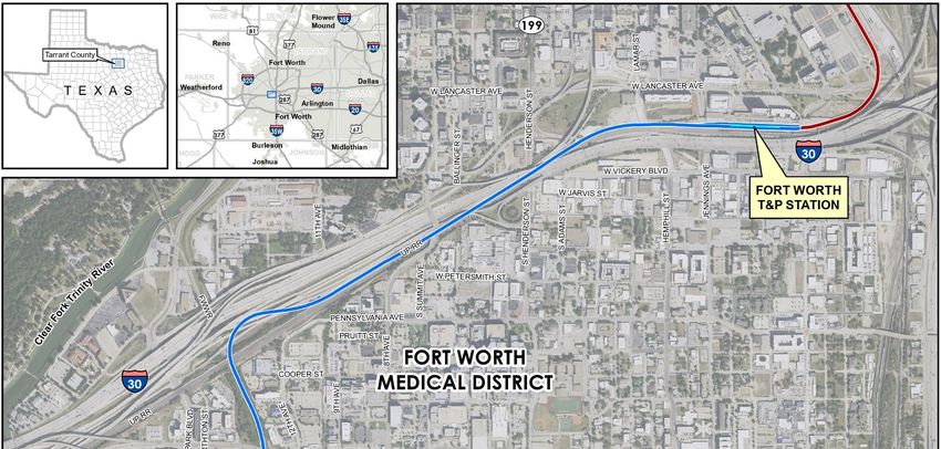
TEXRail Extension

1.0 PROJECT BACKGROUND, PURPOSE OF AND NEED FOR ACTION
This Environmental Assessment (EA) has been prepared in accordance with the National Environmental
Policy Act (NEPA) to evaluate the potential natural, cultural, and socioeconomic effects that may result
from the proposed TEXRail Extension Project in Tarrant County, Texas (TX). Trinity Metro is the Project
sponsor and the Federal Transit Administration (FTA) is the lead federal agency. A list of preparers of
this EA is provided in Appendix A.
This EA has also been prepared in accordance with FTA’s 2019 Standard Operating Procedures for
Managing the Environmental Review Process. Per the Standard Operating Procedures (SOPs), EAs are
concise public documents that include brief discussions of the need for the proposal, alternatives,
environmental impacts of the proposed action and alternatives, and a listing of agencies and persons
consulted. Consistent with the FTA SOPs, data and supporting studies which support the analyses and
findings summarized in this EA are provided in Appendix B: Environmental Resource Technical Reports.

1.1     Project Location
The TEXRail Extension Project is located within the City of Fort Worth and would extend commuter rail
service from the Fort Worth Texas & Pacific (T&P) Station to the proposed Near Southside Station as
illustrated on Figure 1. This extension project is part of the Locally Preferred Alternative (LPA) as a result
of the Alternative Analysis (AA) performed for the 2014 Environmental Impact Statement (EIS) for the
Southwest‐to‐Northeast Rail Corridor, now known as TEXRail (see Section 1.3, Project Background).
TEXRail began operations in January 2019 and currently provides commuter rail service between
Downtown Fort Worth and the Dallas Fort Worth International Airport (DFW Airport).

1.2     Project Description
Trinity Metro is planning to construct a 2.1‐mile commuter rail extension from the Fort Worth T&P
Station, where TEXRail currently terminates, to a proposed station in the Fort Worth Medical District
known as the Near Southside Station (Figure 1). The TEXRail Extension Project would utilize Union Pacific
Railroad (UPRR) right‐of‐way (ROW) and operate on an exclusive track traveling west from the Fort
Worth T&P Station to a connection with the Fort Worth & Western Railroad (FWWR) ROW, where it
would then turn south to transition onto its own alignment adjacent to the FWWR freight track in the
FWWR ROW. The TEXRail Extension Project would utilize the same vehicles currently in use on the
existing TEXRail line that operate between downtown Fort Worth and DFW Airport. Maintenance for the
project would continue to occur at the existing maintenance facility located at 3801 Texrail Avenue in
Fort Worth, TX, near the Mercantile Center Station.

1.3     Project Background
Trinity Metro’s Board of Directors endorsed the TEXRail preliminary LPA in November 2006. In April
2007, Trinity Metro began a Draft Environmental Impact Statement (DEIS) for the 37.6‐mile Southwest‐
to‐Northeast Rail Corridor LPA known as the Commuter Rail Alternative. In 2011, the project was
rebranded as TEXRail. In the Final EIS (FEIS), Trinity Metro included an approximately 27‐mile Commuter
Rail Minimum Operable Segment (MOS) Alternative which was evaluated and compared to the

Environmental Assessment                                                                                     1
TEXRail Extension

                           Figure 1: TEXRail Extension Project Location

Environmental Assessment                                                           2
TEXRail Extension
Commuter Rail Alternative. Trinity Metro chose the Commuter Rail MOS Alternative as the Preferred
Alternative, which terminated in downtown Fort Worth at the Fort Worth T&P Station instead of the
Summer Creek Station in southwest Fort Worth. The FEIS received a Record of Decision from FTA in May
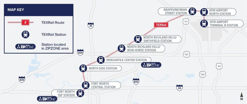
2014 for the Preferred Alternative and TEXRail began operations in January 2019, providing commuter
rail service between Downtown Fort Worth and the DFW International Airport (Figure 2).
Figure 2: Existing TEXRail System
Source: Trinity Metro, 2021.
The approximately 27‐mile TEXRail commuter rail route was completed in January 2019 and was $80.6
million under budget, with roughly half of those funds coming from federal sources and the remainder
from local sources. In March 2020, FTA authorized using the remaining $38.9 million in federal funds to
extend TEXRail 2.1 miles to the proposed Near Southside Station located behind the Baylor Scott &
White All Saints Medical Center, bringing commuter rail service to the Fort Worth Medical District, the
Mistletoe Heights Neighborhood, and the Fairmount‐Southside Historic District, as shown on Figure 1.
1.4 Project Purpose
As determined through consultation with the public, local stakeholders, and government agencies, the
purpose of the TEXRail Extension Project is to:
Provide high quality, safe, reliable, and direct commuter rail service to the Fort Worth Medical
District; one of the region’s most important employment centers; and
Add connectivity to the region for residents in the surrounding neighborhoods including
Mistletoe Heights and the Fairmount‐Southside Historic District, providing direct rail service to
points along the existing TEXRail commuter line; and service to the Dallas Area Rapid Transit
(DART) service area via a transfer from the Trinity Railway Express (TRE) at the Fort Worth T&P
Station, and at the DFW Airport Station (the northern terminus of the existing TEXRail line).
1.5 Project Need
The need for the TEXRail Extension Project includes growth and limited transit access for the businesses
and residences within and surrounding the Fort Worth Medical District. Challenges include:
Environmental Assessment 3TEXRail Extension
Continued residential growth in the surrounding neighborhoods including Mistletoe Heights and
the Fairmount‐Southside Historic District, resulting in increased travel demand in the project
vicinity;
Continued employment growth in the Fort Worth Medical District, attracting increasing levels of
journey‐to‐work trips; and
A lack of direct transit access to DFW Airport and major activity centers beyond Trinity Metro’s
service area for the residents and employees within and near the Fort Worth Medical District.
2.0 ALTERNATIVES CONSIDERED
This EA documents the evaluation of the Build Alternative, the extension of commuter rail service from
the Fort Worth T&P Station to the proposed Near Southside Station located adjacent to the Fort Worth
Medical District. The EA also documents the evaluation of a No‐Build Alternative for comparison of
impacts and benefits to the Build Alternative.
2.1 No‐Build Alternative
The No‐Build Alternative was developed to assess the impacts and the benefits if nothing more is done
beyond what is currently planned in the North Central Texas Council of Governments (NCTCOG) Mobility
2045 Plan (NCTCOG, 2018a), as well as programmed projects in the current 2021‐2024 Transportation
Improvement Program (TIP) for North Central Texas (NCTCOG, 2018b). The environmental impacts as a
result of the planned projects in Mobility 2045 and the TIP would be determined and mitigated through
the environmental analysis processes for each individual project.
The No‐Build Alternative includes Trinity Metro’s existing bus and commuter rail network. Currently
from downtown, the Fort Worth Medical District is served by bus routes number 1 (along Hemphill/
Jennings Streets) and 4 and 6 (along 8th Avenue). The No‐Build Alternative will generally have these bus
services operate as they do today. No extension of the TEXRail commuter rail route will be provided. The
No‐Build Alternative will provide the baseline against which the Build Alternative will be compared.
2.2 Build Alternative
The TEXRail Extension Project would extend TEXRail commuter rail service approximately 2.1 miles south
from the Fort Worth T&P Station to the proposed Near Southside Station. From the existing Fort Worth
T&P Station, TEXRail would extend west using the northernmost track along the UPRR mainline that runs
adjacent to Interstate Highway (I)‐30/Chisholm Trail Parkway to approximately 11th Avenue where the
TEXRail track would transition north off of the UPRR mainline alignment onto its own alignment heading
underneath the Chisholm Trail Parkway lanes in what is known as a jug‐handle configuration turning
south to connect with the FWWR corridor. Trinity Metro met extensively with the North Texas Tollway
Authority (NTTA) during the previously completed AA and EIS to ensure that adequate space would be
preserved under the freeway bridge columns to allow for TEXRail to connect with the FWWR rail line
under the Chisholm Trail Parkway freeway lanes. The new TEXRail track heading south would generally
be located within FWWR ROW to Mistletoe Boulevard, with a minimum of 20 feet between the existing
freight track (measured from centerline to centerline). Detailed plan and profile drawings of the TEXRail
Extension Project are included as Appendix C: Engineering Drawings.
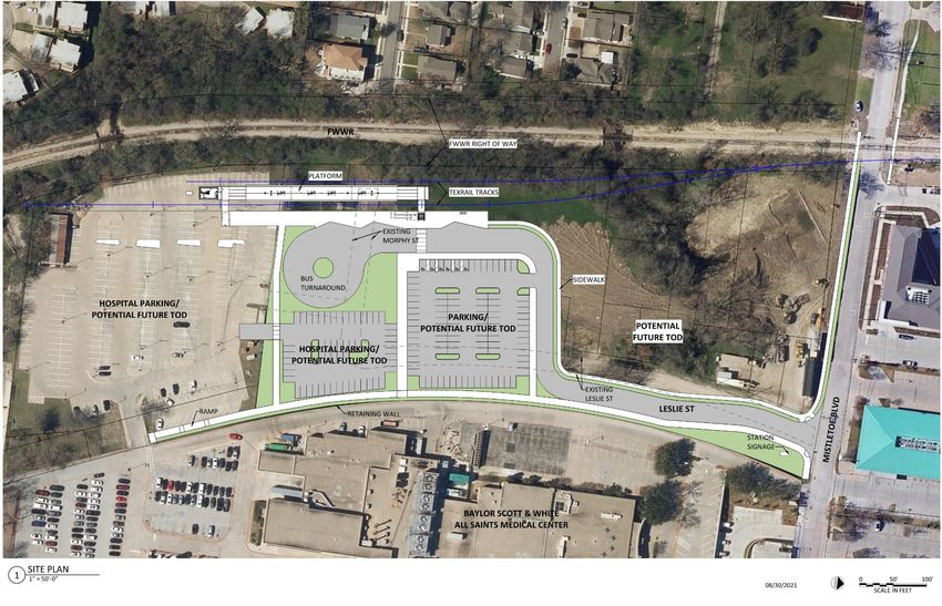
The proposed Near Southside Station would serve one of the largest employment centers in the region.
The station would draw employees and business patrons from the surrounding medical and office
complexes, including five major hospitals (Baylor Scott & White All Saints Medical Center, Cooks
Children's Hospital, Harris Methodist Hospital – Fort Worth, and Plaza Medical Center) located within
Environmental Assessment 4TEXRail Extension one mile of the station. The station would also be in proximity to several established residential areas, and would draw residents from the Fairmount, Berkeley Place, and Mistletoe Heights neighborhoods. The station would also be in proximity to several regional roadways, including I‐30, Rosedale Street, and Forest Park Boulevard. The concept for the proposed Near Southside Station as shown in Figure 3 would provide space for 100 vehicles and three bus bays for transit users. As depicted in Figure 3, the proposed Near Southside Station would also provide multiple opportunities for transit‐oriented development (TOD) as further described in Section 3.2, Land Use and Economic Development. With the implementation of the TEXRail Extension Project, Trinity Metro would re‐route nearby local bus to feed into the station as further described in Section 3.1, Transportation. Environmental Assessment 5
TEXRail Extension

                           Figure 3: TEXRail Extension Proposed Near Southside Station Concept

Environmental Assessment                                                                                        6
TEXRail Extension
3.0 AFFECTED ENVIRONMENT AND ENVIRONMENTAL
CONSEQUENCES
Chapter 3.0 summarizes the existing natural, physical, and cultural environments within the TEXRail
Extension Project. The detailed evaluations for these resources are provided in Appendix B:
Environmental Resource Technical Reports. Each section describes the Study Area for that particular
resource area. Resource Study Areas vary from the footprint or limits of disturbance (LOD) of the TEXRail
Extension Project, where construction would occur (for example [e.g.], acquisitions would only occur at
properties within the LOD adjacent to the Project), to one‐half mile from the project (e.g.,
transportation corridors could see traffic impacts a half‐mile [or more] away as transit patrons drive to
park at transit stations).
A summary of the evaluation results across all resources for the TEXRail Extension Project is provided in
Section 3.15 Summary of Environmental Analysis Resource Areas.
3.1 Transportation
This section provides a summary of transportation infrastructure including transit, freight, pedestrian
and bicycle facilities networks, as well as traffic and parking within the Study Area, which is defined as a
one‐half mile radius buffer from the project LOD. For a more detailed discussion of Transportation
resources, please see Chapter 1.0: Transportation, Appendix B2: Physical Resources Technical Report.
3.1.1 Affected Environment
Transit: Trinity Metro currently provides bus and/or rail services to Fort Worth, Blue Mound, Grapevine
and North Richland Hills in Tarrant County, Texas.
Trinity Metro operates several bus routes that serve the Fort Worth Medical District including Routes 1,
4, and 6 (Route 5 also serves the area, but operates along South Main Street, on the eastern edge of the
Medical District). These routes currently operate on a 15‐ or 30‐minute service through the Study Area.
In 2020, Trinity Metro introduced ZIPZONE service in the Near Southside neighborhood, which is a
ridesharing transit solution that uses smartphone technology and a fleet of dedicated vehicles to
provide first‐ and last‐mile trips within specific service boundaries. ZIPZONE allows passengers to
request trips in real time through the app or over the phone by selecting a pickup point and destination.
The service in the Near Southside neighborhood operates from 6:00 am to 8:00 pm and costs $3.00 per
ride (or is included for free when transferring from a bus route or commuter rail line). ZIPZONE transfer
service provided within the existing TEXRail system is shown in Figure 2.
Trinity Metro jointly operates TRE commuter rail service (with DART) to Union Station in downtown
Dallas. TRE operates six days per week, operating every 30‐minutes during peak periods and hourly
during off‐peak periods. Trinity Metro also operates the existing TEXRail commuter rail service between
downtown Fort Worth and DFW Airport. TEXRail provides service seven days per week, operating on the
same schedule every day with trains operating every 30‐minutes during peak periods and hourly during
off‐peak periods. Both rail services currently terminate at the Fort Worth T&P Station.
Freight Rail: The freight railroad network in the Study Area includes the UPRR, a Class‐1 railroad, and
FWWR, a Class‐2 short‐lined railroad. The UPRR mainline runs along I‐30 with four tracks through this
segment of Fort Worth between UPRR’s Davidson Yard on the west and Tower 55 (one of the nation’s
busiest and most congested rail intersections) on the east. FWWR is headquartered in Fort Worth with
Environmental Assessment 7TEXRail Extension trackage on the west side of downtown running south and crossing under I‐30 on single tracks adjacent to the Fort Worth Medical District and then south along Granbury Road. Pedestrian and Bicycle Facilities: The Fort Worth Active Transportation Plan (2019) is Fort Worth’s first citywide trails master plan. Active transportation includes walking, bicycling, wheelchair use, and all non‐motorized means of travel for transportation and recreation (City of Fort Worth, 2019). The plan emphasizes local, short trips and connections to transit. Principally, the plan prioritizes walking and biking‐related projects that create comfortable and connected access to transit. Existing pedestrian facilities in the Study Area include trails along the Clear Fork of the Trinity River and sidewalks along numerous streets including within the Mistletoe Heights and Fairmount neighborhoods. Existing sidewalks within the Study Area are generally in good condition with the exception of a few intersections (see Chapter 1.0: Transportation, Appendix B2: Physical Resources Technical Report). The Fort Worth Active Transportation Plan has outlined areas with sidewalk gaps (where sidewalks do not exist or are not adequate for pedestrian connectivity). The plan outlines network priorities and states that sidewalk networks should not have gaps and should be in good condition, as well as being Americans with Disabilities Act (ADA)‐accessible. A few sections of poor sidewalk conditions are located east of the TEXRail Extension Project, south of Rosedale Street and north of West Myrtle Street. There are also sidewalk gaps in the Study Area along Mistletoe Boulevard, Beckham Place, and Leslie Street. Existing bicycle infrastructure in the Study Area includes a combination of sharrows (shared lanes), wide shoulders, signage, bicycle lanes, and multi‐use paths. Existing bicycle facilities include areas that have dedicated on‐street bicycle infrastructure (in other words [i.e.], sharrows). Sidepaths include dedicated and marked bicycle‐only lanes. In 2013, Fort Worth Bike Sharing launched a B‐cycle system consisting of 300 bikes and 30 stations serving Downtown, Near Southside (with several locations including one in proximity to the Project at Enderly Place and West Allen Avenue), and the Cultural District. With 350 bikes and 46 stations, the organization provided over 58,000 bike trips accounting for 277,000 miles in 2019. The B‐cycle system is now operated by Trinity Metro. Traffic: Mistletoe Boulevard and Leslie Street are vital routes to the Near Southside Station, as they provide a direct connection to the TEXRail Extension from the surrounding Hospital District and neighborhoods. Existing traffic counts in the Study Area were taken on March 4, 2021. However, due to COVID‐19 they were not considered typical counts and an adjustment factor was determined to account for this. See Figure 4 for more detail on the COVID‐19 factor and development of existing volumes. As traffic volumes return to normal, travel patterns in the corridor appear to be returning to pre‐pandemic levels. Turning movement counts (TMCs) were collected at all intersections, excluding the railroad crossing, for 12 hours (7:00 am to 7:00 pm) to capture both the morning and evening peak periods. The intersection analysis revealed all intersection movements currently operate with an acceptable Level of Service (LOS). It should be noted that all movements are operating at LOS C or better except for the eastbound left at 8th Avenue which operates at LOS D in the am peak hour and LOS E in the pm peak hour. This movement is currently stop‐controlled and vehicles must traverse two lanes and a center two‐way left turn lane to complete the turning movement. Traffic analyses further evaluated the existing corridor, defined as Mistletoe Boulevard between Forest Park Boulevard on the west and 8th Avenue on the east. The existing Mistletoe Boulevard corridor experiences slightly longer travel times and lower vehicle speed in the am peak hour compared to the PM peak hour. Additionally, in both peak hours, the westbound travel time was found to be longer than the eastbound. For additional information regarding traffic operations, see Appendix E: Traffic Operations Report. Environmental Assessment 8
TEXRail Extension
Figure 4: COVID‐19 Adjustment Factor
Excerpt from Transportation Memo – COVID‐19 Adjustment Factor
The COVID‐19 Pandemic has impacted typical traffic patterns. The repercussions on schools, commercial
developments, businesses, and the expansion of telework have reduced the total amount of motor vehicle
traffic. For the purposes of this study, the development of a COVID‐19 adjustment factor was determined as an
appropriate approach to account for the change in traffic patterns and estimate the expected 2021 traffic
under normal traffic conditions. This factor will be developed using the following methodology:
12‐hour traffic counts will be collected at the previously specified locations on the corridor (along Mistletoe
Boulevard).
Historic data at a TxDOT count location along Park Place Avenue East of Warner Road (220HP5727) will be
used to estimate an average annual growth rate. This location was selected as it has a similar connectivity
between Forest Park Boulevard and 8th Avenue and has both a 2014 and 2019 count available.
Historic data at a TxDOT count location along Mistletoe Boulevard west of Beckham Place (220U1943) will
be used to compare to the count data being collected. This location was chosen as it coincides with one of
the approaches at an intersection for which data is being collected. Data at this location is only available for
2014 so the growth rate calculated along Park Place Avenue will be applied to adjust this count data to
2021. This COVID‐19 adjustment factor will then be calculated on an hourly basis and applied to all collected
traffic counts. This is done on an hourly basis as the daily travel patterns have shifted from typical travel
patterns associated with pre‐COVID‐19 Pandemic conditions.
Parking: Within the Study Area, Trinity Metro provides approximately 100 free parking spaces at the
Fort Worth T&P Station for transit patrons using TEXRail and TRE commuter rail service. No overnight
parking is allowed. There is also paid parking available in the lots surrounding the Fort Worth T&P
Station. The southern extent of the Study Area includes an approximately 2.4‐acre parking lot for
employees of the Baylor Scott & White All Saints Medical Center. The medical center provides parking to
visitors in its parking structure located at 8th Avenue and Enderly Place. Other medical clinics in the
surrounding area provide off‐street parking for their employees and visitors. In addition, on‐street
parking is available on local streets in and around the Study Area.
3.1.2 Environmental Consequences
Transit: Under the No‐Build Alternative, Trinity Metro’s existing bus and commuter rail network would
in large part remain as it is today, with regular modifications on individual routes based on ridership and
other service planning measures. Currently from downtown, the Fort Worth Medical District is served by
bus routes number 1 (along Hemphill/Jennings Streets), 4, and 6 (along 8th Avenue). The No‐Build
Alternative would generally operate these bus services as they operate today. No extension of the
TEXRail commuter rail route to the Fort Worth Medical District area would be provided.
Under the Build Alternative, the TEXRail Extension Project would be implemented and is anticipated to
enhance transit service in the Fort Worth Medical District area with the introduction of commuter rail
service to the proposed Near Southside Station. TEXRail service would operate from 4:00 am to 1:00 am.
Trinity Metro Routes 4 and 6 would be re‐routed to allow buses to serve the proposed Near Southside
Station, which will include three bus bays. There would be only minimal impacts to travel times for the
existing bus service. However, this would be offset by providing a direct connection to commuter rail
service in the Near South Side area. No other impacts to transit service are anticipated based on the
implementation of the TEXRail Extension Project. Minor construction impacts would occur at the
Mistletoe Boulevard intersection, where new tracks would be placed to connect the proposed Near
Southside Station to the railroad ROW.
Environmental Assessment 9TEXRail Extension Freight Rail: Under the No‐Build Alternative, UPRR and FWWR freight rail operations within the Study Area would run as they do today. Under the Build Alternative, TEXRail would extend west using the northern most track along the UPRR mainline that runs adjacent to Interstate Highway (I)‐30/Chisholm Trail Parkway to approximately 11th Avenue where the TEXRail track would transition north off of the UPRR mainline alignment onto its own alignment heading underneath the Chisholm Trail Parkway lanes in what is known as a jug‐handle configuration turning south to connect with the FWWR corridor. The new TEXRail track would generally be located within FWWR ROW to Mistletoe Boulevard, with a minimum of 20 feet between the existing freight track (measured from centerline to centerline). Trinity Metro has worked extensively with both the UPRR and FWWR to ensure existing freight operations would be maintained as a result of the TEXRail Extension Project. The proposed project includes the replacement of the existing 1925 UPRR Steel Trestle Bridge spanning the FWWR ROW that supports the UPRR Mainlines 3 and 4. The replacement of the bridge is required to accommodate the track alignment for the proposed TEXRail Extension south into the Medical District. Replacing the bridge will require construction of a shoofly bridge (a temporary bridge that will allow trains to continue to operate along this segment while the bridge is reconstructed) to the north in order to maintain UPRR operations of all four tracks on the Dallas Subdivision. Approximately two miles of UPRR mainline track will be shifted temporarily to accommodate the new bridge construction. At the conclusion of the bridge replacement, the mainline tracks, turnouts, crossovers, and signal equipment will be shifted to their original location and the temporary shoofly bridge will be removed. With the construction of the shoofly bridge, there would be only minimal potential impacts to freight rail operations. Pedestrian and Bicycle Facilities: Under the No‐Build Alternative, sidewalk and bicycle facilities would continue to be implemented city‐wide in accordance with the Fort Worth Active Transportation Plan (2019) (City of Fort Worth, 2019). Currently, there are sidewalks on much of the north side of Mistletoe Boulevard but there is a missing segment between Beckham Place and just west of the FWWR tracks. Additionally, there are no sidewalks on the south side of Mistletoe Boulevard. Under the Build Alternative, the missing segment on the north side of Mistletoe Boulevard between Beckham Place and just west of the FWWR tracks would be completed by the City of Fort Worth as part of the implementation of the planned quiet zone project at Mistletoe Boulevard. A new sidewalk on the south side of Mistletoe would be constructed by Trinity Metro. Additionally, sidewalks would be built along both sides of Leslie Street to connect to the proposed Near Southside Station. Finally, as Mistletoe Boulevard is currently signed as a bicycle route, bicycle‐friendly track crossings would be implemented into the design of the new crossing at Mistletoe Boulevard. Furthermore, the proposed Near Southside Station would offer bicycle racks as an amenity at the station, consistent with other TEXRail Stations increasing regional access for bicyclists in the area. Traffic: An operational analysis was completed in June 2021 and updated in August 2021 (as part of the TEXRail Extension EA) for the No‐Build Alternative opening year (2025) and horizon year (2045) and the Build Alternative opening year (2025) and horizon year (2045) scenarios adjacent to the proposed Near Southside Station and along Mistletoe Boulevard from Forest Park Boulevard to 8th Avenue in Fort Worth (See Appendix E: Traffic Operations Report). Under the No‐Build Alternative, nothing more would be done to the existing transportation network beyond what is currently planned in the NCTCOG Mobility 2045 Plan (NCTCOG, 2018a), as well as Environmental Assessment 10
TEXRail Extension

programmed projects in the current 2021‐2024 TIP for North Central Texas (NCTCOG, 2018b). The
impacts to traffic as a result the planned projects in Mobility 2045 and the TIP would be determined and
mitigated through the environmental analysis processes for each individual project.
Under the No‐Build Alternative, all intersections along the Mistletoe corridor between Forest Park
Boulevard and 8th Avenue are projected to operate with acceptable LOS in the 2025 opening year and in
the 2045 horizon year. While each of the full intersections would operate and acceptable LOS, the
eastbound left turn from Mistletoe Boulevard at 8th Avenue in the PM peak hour is currently operating
at LOS E. The eastbound approach at 8th Avenue is stop‐controlled and left‐turning vehicles currently
have difficulty finding adequate gaps to make this turning movement. Initial modeling results showed
that this turning movement would continue to worsen into the future, and a signal would be warranted
at this location. However, based on coordination with City of Fort Worth traffic engineering staff, a
signal at this location would not be feasible due to spacing requirements of signalized intersections.
Instead, the City has plans to reconfigure the eastbound approach to prohibit left turns (to northbound
8th avenue). With this improvement, traffic projections show this intersection to operate at acceptable
LOS in both 2025 and 2045.
Under the Build Alternative, all intersections along the Mistletoe corridor are projected to operate with
acceptable LOS in both 2025 and in 2045. The Mistletoe Boulevard and 8th Avenue intersection would
continue to operate with an acceptable LOS in both 2025 and 2045 under the Build Alternative, with the
prohibited left turn onto northbound 8th Avenue. Both Trinity Metro bus routes 4 and 6 would be re‐
routed to travel to the Near Southside Station along Mistletoe Boulevard between Leslie Street and 8th
Street, and then back out to 8th Avenue likely via 9th Avenue and Rosedale Street. The addition of buses
along this segment would not have a significant impact on traffic operations along Mistletoe Boulevard.
The TEXRail Extension Project would not impact the LOS at intersections within the Study Area. As
previously discussed, despite the increases in traffic demand generated by the proposed Near Southside
Station, all intersections would continue to operate at an acceptable LOS (A‐C). Mistletoe Boulevard
travel times would also remain similar to existing travel times under the Build Alternative.
Access to the proposed Near Southside Station would be from Leslie Avenue, which would be realigned
for the project. Leslie Avenue would be reconstructed from Mistletoe Boulevard to the proposed Near
Southside Station and would include a sidewalk on both sides to provide pedestrian access to the
station.
Parking: Under the No‐Build Alternative, there would be no extension of the existing TEXRail service to
the Fort Worth Medical District, thus no change to the parking spaces currently reserved for Baylor Scott
& White All Saints Medical Center employees.
There are currently 264 parking spaces on 2.4 acres reserved for hospital employees behind Baylor Scott
& White All Saints Medical Center. For the Build Alternative, 100 new parking spaces would be provided
at the proposed Near Southside Station for transit patrons. Trinity Metro would acquire a portion of the
2.4‐acre medical center parking lot adjacent to the proposed station to accommodate the required 100
parking spaces. In addition, Trinity Metro would acquire a portion of the medical center parking lot to
accommodate the station platform and tail tracks. The area required to accommodate the station would
impact 55 employee parking spaces. Trinity Metro would replace the employee parking spaces that the
project displaces by reconfiguring the remaining portion of the parking lot that is located closer to the
medical center and by building two new parking lots to the north of the existing lot. To connect the
parking lots, Trinity Metro would remove approximately six additional parking spaces in the rear of the
existing parking lot to build new sidewalks between the parking lots. The lots could also provide parking

Environmental Assessment                                                                               11
TEXRail Extension
for future TOD if implemented (as previously shown in Figure 3). With the replacement of the impacted
medical center parking spaces, there would be no loss of employee parking.
3.1.3 Mitigation Measures
As previously discussed, for the transit, freight, pedestrian and bicycle facilities, and traffic
transportation resources in the Study Area, no mitigation measures would be required as a result of the
TEXRail Extension Project due to the following:
Changes to the transit network are anticipated to be positive with the implementation of the
TEXRail Extension Project providing an enhanced transit service for the Fort Worth Medical
District;
UPRR and FWWR operations would run as they do today;
new sidewalks would be constructed to connect the proposed Near Southside Station to the
surrounding community and the completion of the missing sidewalk segment on the north side
of Mistletoe Boulevard between Beckham Place and just west of the FWWR tracks by the City of
Fort Worth as part of the planned quiet zone project at Mistletoe Boulevard, on the south side
of Mistletoe Boulevard between Leslie Street and the FWWR track, and along Leslie Street
would be completed by Trinity Metro; and
vehicle travel times along Mistletoe Boulevard between Forest Park Boulevard and 8th Avenue
would be minimally impacted with the implementation of the Build Alternative.
For parking mitigation measures, impacted parking spaces for Baylor Scott & White All Saints Medical
Center employees would be reconfigured but replaced within the same area and at a location closer to
the medical center. In addition, while parking is generally allowed on most local streets in the area, the
implementation of signage and enforcement would be used to discourage all‐day parking by transit
users if this should become a problem.
3.2 Land Use and Economic Development
The TEXRail Extension Project is located within the limits of the City of Fort Worth, which is the
municipal agency responsible for land use planning. For a more detailed discussion of Land Use and
Economic Development, please see Chapter 3.0: Land Use and Economic Development, Appendix B2:
Physical Resources Technical Report.
3.2.1 Affected Environment
The land use Study Area, defined as one‐half mile on either side of the TEXRail Extension Project LOD, is
located west and south of downtown Fort Worth. This area is consistent with the urban downtown and
primarily consists of office buildings, government buildings, light industrial, mixed‐use residential and
transportation uses. The eastern and northern portions of the Study Area are more densely developed
due to their proximity to downtown. The western and southern portions are generally less dense and
include more single‐family residential uses.
The southern portion of the Study Area consists of predominantly high‐density, mixed‐use, pedestrian‐
oriented developments that are part of the City of Fort Worth’s Near Southside “NS” Mixed‐Use/Form
Based zoning. The northern portion of the Study Area, located north of I‐30, abuts downtown Fort
Worth and is zoned Central Business High Intensity. This zoning designation allows intensive commercial
uses and high‐density residential and office uses.
Environmental Assessment 12TEXRail Extension Other land uses in the Study Area include parklands and open space, namely Newby Park, which is located directly west of the FWWR ROW between West Rosedale Street and Mistletoe Boulevard. Newby Park is a neighborhood park located at 1105 Jerome Street that features a playground, swings, baseball fields, basketball courts, and covered pavilions, and serves the Mistletoe Heights neighborhood. There have been several new developments that have occurred in recent years in the Near Southside area, including several new apartment buildings, new medical facilities, a transitional care facility and a new hotel. 3.2.2 Environmental Consequences Under the No‐Build Alternative, forecasted growth trends will continue as forecasted. Nothing more would be done beyond what is currently planned in the NCTCOG Mobility 2045 Plan (NCTCOG, 2018a), as well as programmed projects in the current 2021‐2024 TIP for North Central Texas (NCTCOG, 2018b). Changes to land use as a result the planned projects would be determined and mitigated through the environmental analysis processes for each individual project. As a result of the Build Alternative, current transportation land use would largely remain the same, considering the existing UPRR and FWWR railroad corridors that would be utilized for the TEXRail Extension Project. However, the existing land use surrounding and including the proposed Near Southside Station area would be converted to transportation use. This would include 26 parcels considered vacant by the Tarrant County Appraisal District land use codes (2021), but currently owned by Baylor Health Care Systems, including the parking lot currently utilized for Baylor Scott & White All Saints Medical Center employee parking, as discussed in Section 3.1, Transportation. In addition to the 26 parcels mentioned above, the Build Alternative would require the partial acquisition of seven properties along the east side of the FWWR alignment where additional property would be required to maintain the 20‐foot distance between the proposed TEXRail passenger track and the existing FWWR freight track and meet minimum clearance from the bridge columns at Rosedale Street. Trinity Metro has been in discussions with Baylor Health Care Systems about acquiring these parcels required for the TEXRail Extension Project station area through a purchase by Trinity Metro. Parking areas may be acquired as an easement to allow Baylor Scott & White to utilize for future TOD on the property surrounding the proposed Near Southside Station. The addition of a commuter rail station to the area would likely increase market demand and could spur denser TOD in the area. TODs typically require compact development and can vary by their location, size, composition and function to fit the respective market needs for housing, retail and/or commercial space. The proximity to the Baylor Scott & White All Saints Medical Center, a major employer, would provide connections to daily riders who would likely commute to and from work using transit. TOD at the proposed Near Southside Station area has the potential to create a destination hub, where complementary land uses to the current medical land uses could be used to create a “neighborhood” focus. The “NS” zoning designation would support a high‐density and walkable TOD in this area. Additionally, while parking at both the station for transit riders and at the Baylor Scott & White All Saints Medical Center employee parking is currently a surface parking lot, a TOD development would have the potential reconfigure these parking areas in the future if a parking structure is built at this location to support all uses. While TOD remains a possibility at this location, there are no specific plans for a new development at this location at this time. Minor construction impacts could occur as a result of construction noise, dust, and construction work that requires the closure of traffic lanes. Environmental Assessment 13
TEXRail Extension

3.2.3 Mitigation Measures
The vacant land currently owned by Baylor Health Care Systems would need to be acquired either
through a purchase or as an easement for the proposed Near Southside Station. To minimize disruption
to the Baylor Scott & White All Saints Medical Center and other nearby businesses during construction,
Trinity Metro will continue ongoing coordination during final design and through construction.
Additionally, to minimize disruption to the medical center’s employees, coordination will continue
between the Baylor Health Care Systems and Trinity Metro to ensure parking needs are addressed
during all periods of construction.

3.3      Neighborhoods
This section summarizes socioeconomic conditions within the Study Area through a demographic
assessment and an assessment of adjacent communities, community facilities, and environmental
justice. For a more detailed discussion of Neighborhoods, please see Chapter 4.0: Neighborhoods,
Appendix B2: Physical Resources Technical Report.

3.3.1 Affected Environment
Demographic Characteristics: For the neighborhoods Study Area, which was defined as a quarter‐mile
buffer from the TEXRail Extension Project LOD, data was gathered from the United States (U.S.) Census
Bureau’s (USCB’s) 2019 American Community Survey (ACS) 5‐year estimates (USCB, 2019) and the
NCTCOG 2045 Demographic Forecast (NCTCOG, 2019). Table 1 displays population characteristics within
the select block groups with the Study Area and the greater Tarrant County.
                    Table 1: Demographic Characteristics of the Study Area and County
                                                                    Study Area          Tarrant County
                   Demographic Characteristic
                                                                Number     Percent    Number      Percent
 Total Population                                               14,011               2,049,770
 Hispanic or Latino Origin                                       2,994      21.4%     590,485      28.8%
 White Alone                                                    11,097      79.2%    1,374,182     67.0%
 Black or African American Alone                                 1,490      10.6%     338,378      16.5%
 American Indian and Alaska Native Alone                          32         0.2%     10,343       0.5%
 Asian Alone                                                      396        2.8%     111,274      5.4%
 Native Hawaiian and Other Pacific Island Alone                    0         0.0%      3,946       0.2%
 Some other race alone                                            682        4.9%     146,177      7.1%
 Two or more races                                                314        2.2%     65,470       3.2%
 Two races include some other race                                44         0.3%     1,1993       0.6%
 Two races excluding some other race, and three or more races     270        1.9%     53,477       2.6%
 Poverty                                                         1,100       7.9%     241,703      11.8%
 Limited English                                                  602        4.3%     114,267      5.6%
Note: Numbers do not add to total
Source: USCB, ACS 2019 5‐Year Estimates

Communities and Environmental Justice (EJ): Communities can generally be defined by their geography,
characteristics and cohesion. Drivers of these factors include typology, diversity, and special location of
physical structures, population density, aesthetic and visual appearance, and general assortment of land
uses. Additionally, a community’s cohesion is reflected in the neighborhood’s ability to function and be
recognized by its residents and visitors. Cohesion can be a function of density, mobility, and

Environmental Assessment                                                                                14
TEXRail Extension connectivity. Linear transportation infrastructure has historically created localized barriers that can hinder community cohesion. Seven communities or neighborhoods were identified within the Study Area including Berkley Place, Fairmount, Mistletoe Heights, Sunset Terrace, Texas and Pacific Lofts, Bricktown, and Near Southside Inc. In addition, multiple community facilities are in the Study Area including schools, fire stations, and hospitals (see Table 4‐6 in Chapter 4.0: Neighborhoods, Appendix B2: Physical Resources Technical Report). As discussed in the demographic assessment in Chapter 4.0: Neighborhoods, Appendix B2: Physical Resources Technical Report, communities within the Study Area range in diversity and income levels. Minority and/or low‐income populations, as well as limited English‐speaking populations can be found throughout the Study Area; however, higher densities of communities were identified in the eastern portions of the Study Area. Per FTA Circular 4703.1, Environmental Justice Policy Guidance for FTA Recipients (FTA, 2012), EJ analysis requires both demographic research and public engagement to determine how the proposed project would affect minority and/or low‐income populations. In the block group closest to proposed Near Southside Station, median home prices are nearly $93,000. Additionally, this block group has 1 percent of the population classified as low‐income and 4 percent identified as a minority population. Other surrounding block groups have similar statistics (see the Neighborhoods Chapter of the Appendix B2: Physical Resources Technical Report). Finally, a virtual public meeting for this TEXRail Extension Project was conducted on Thursday, April 15, 2021 (see Appendix D: Public and Agency Involvement Materials). 3.3.2 Environmental Consequences Under the No‐Build Alternative, the TEXRail Extension Project would not be built or have impacts to existing neighborhoods in the Study Area. Existing and future planned projects would likely continue, and current economic trends would occur within the Study Area. Under this alternative, an extension of the existing TEXRail commuter rail service would not be built, thus not providing an enhanced transit service for the local neighborhoods and EJ populations in the Study Area. Under the Build Alternative, potential long‐term impacts analyzed as a result of the TEXRail Extension Project to the surrounding community including minority, low‐income, and/or limited populations could include impacts to community cohesion, parcel acquisition/displacement, noise and vibration, and economic impacts, as discussed below. Under the Build Alternative, the TEXRail Extension Project would primarily occur within existing transportation ROW adjacent to the communities presented in Section 3.3.1. Potential impacts to community cohesion as a result of the Build Alternative would be minimal. The introduction of new linear commuter rail infrastructure into the existing freight railroad ROW would not constitute a new linear barrier that would inhibit neighborhood function or mobility within the Study Area. The project would have the potential to minimally increase commuter vehicle traffic in and around the proposed Near Southside Station specifically during morning and evening peak commute periods. However, as previously discussed, the project would not have a significant impact on the current LOS at nearby intersections and the addition of mobility options within the community would represent a beneficial impact by increasing regional connectivity and travel options. Noise impacts would occur near the proposed Near Southside Station including a moderate noise impact at Story Stage School (see Section 3.6, Noise and Vibration). The majority of the noise impacts as a Environmental Assessment 15
TEXRail Extension

result of the TEXRail Extension Project are projected to result from trains sounding horns as they
approach the Mistletoe Boulevard at‐grade crossing.
For the Build Alternative, most of the property (except for the southern terminus of the LOD) would be
within existing freight railroad ROW. Trinity Metro would operate commuter rail service through railroad
agreements between both the UPRR and FWWR. TEXRail passenger rail service would operate within
the freight rail ROW through permanent easements as outlined in the forthcoming railroad agreements.
Additionally, there are seven properties along the east side of the FWWR alignment where additional
property would need to be required to maintain the 20‐foot distance between the proposed TEXRail
passenger track and the existing FWWR freight track. These would all be partial acquisitions totaling 0.7
of an acre located along the FWWR freight rail alignment. No displacements would be required.
At the southern terminus of the LOD, at the site of the proposed Near Southside Station area, the
project would require additional ROW outside of the existing railroad ROW. Specifically, Trinity Metro
would acquire all or a portion of 26 parcels of property.
No disproportionate or adverse impacts from displacements or acquisitions would occur to minority,
low‐income, and/or limited English speaking populations in the Study Area.
Potential impacts to the local economy as a result of the TEXRail Extension Project could include delay or
deferment of planned projects and conversely the implementation of new projects due to a new
passenger rail station and transportation possibilities.
Positive effects between residential and commercial property values and rail and transit stations are
documented with examples seen around the U.S. and in the Dallas‐Fort Worth region. Potential impacts
relating to property values nearby the proposed Near Southside Station area could potentially increase
as a result of the additional mobility options provided by the TEXRail Extension Project.
Parcels to be acquired through a purchase by Trinity Metro for the proposed Near Southside Station are
owned by Baylor Health Care Systems; therefore, potential impacts due to deferment, adjustment, or
cancellation would not be disproportionate and adverse to minority and/or low‐income populations or
adjacent neighborhoods. No potential projects outside of the LOD would be anticipated to be impacted.
Therefore, potential economic impacts to minority and/or low‐income populations as a result of the
TEXRail Extension would not be anticipated.
During the construction period, potential impacts may include temporary disruption of traffic,
temporary noise, and localized air quality impacts. However, with the mitigation measures outlined in
Section 3.1, Transportation, Section 3.5, Air Quality, and Section 3.6 Noise and Vibration, potential
impacts would be minimized and/or mitigated by best management practices (BMPs). In addition,
construction period impacts would not be predominantly borne by minority, low‐income, and/or limited
English speaking populations and therefore not be disproportionate and adverse.

3.3.3 Mitigation Measures
Potential impacts to communities and minority and/or low‐income populations within the Study Area
would primarily be related to noise impacts; however, Trinity Metro intends to avoid the routine
sounding of commuter train horns near this location by working with local, state, and federal agencies
(as needed) to establish a quiet zone in the vicinity of this grade crossing (see Section 3.6 Noise and
Vibration). Therefore, noise impacts to the surrounding community, including minority, low‐income,
and/or limited populations, with quiet zone mitigation would not have residual noise impacts.

Environmental Assessment                                                                                  16
You can also read