Sussex Flow Initiative Natural Flood Management Project - End of Year Report 2018/19
←
→
Page content transcription
If your browser does not render page correctly, please read the page content below
Sussex Flow Initiative
Natural Flood Management Project

       End of Year Report
            2018/19
Summary
The Sussex Flow Initiative (SFI) is a Natural Flood Management (NFM) project on the River Ouse
catchment in East Sussex. The project began as a trial in 2012, and is a collaboration between Sussex
Wildlife Trust, the Woodland Trust, and the Environment Agency. This report highlights the project’s
achievements in terms of NFM demonstration and advocacy during 2018-2019.

By working closely with landowners, local communities, and local authorities, the Sussex Flow
Initiative has delivered NFM throughout the Ouse catchment, directly influencing approximately 420
hectares of land, and providing advice to landowners of 2460 hectares of land. The NFM techniques
that have been utilised include tree planting (with over 10,650 trees being planted in 2018/19 in the
form of 1.62 km of hedgerow and 1.61 ha of woodland), >90 natural woody structures installed in
streams, as well as the creation/restoration of 1.5 hectares of temporary flood water storage and
wildlife habitat. The additional water storage created by this work is estimated to be approx.
3,780,000 L per flood event, and the hedgerow and woodland are expected to increase soil infiltration
rates within fields by up to 60 times, helping to intercept surface runoff. The woodland and hedgerow
planting are also estimated to sequester up to 92 tonnes of CO2. The Sussex Flow Initiative has
contributed 7.0 hectares to Environment Agency targets for the restoration/creation of priority
habitat, and has also provided advice to riparian landowners alongside > 7.5 km of river/stream failing
to meet Water Framework Directive (WFD) targets for phosphorous. Furthermore, the Sussex Flow
Initiative’s NFM delivery has taken place upstream of 18 properties (north of Lewes) considered by
the Environment Agency to be at ‘very significant risk’ of flooding.

In addition to the delivery of NFM, SFI helps others to use and understand the approach, by sharing
case studies, knowledge and experiences with other organisations considering NFM. By utilising best
practice and disseminating our findings using a wide range of media, we try to positively influence
the uptake of NFM throughout England and further afield. Through a combination of print, broadcast
(Radio Uckfield interview), and digital (websites, blogs, Twitter, YouTube, Facebook) media, our
message has potentially reached audiences of > 170,000 people.

The Sussex Flow Initiative continues to build on its previous work and the momentum provided by
the launch of the Environment Agency’s national programme of NFM in 2017, entitled ‘Working with
Natural Processes’. We will continue to deliver ambitious targets and to build new partnerships with
organisations and local authorities with the shared goal of increasing the resilience of local
communities to flooding.
Table of contents
Summary .....................................................................................................................................2
Table of contents .........................................................................................................................3
Introduction and project background ...........................................................................................4
Project achievements 2018 – 2019 ...............................................................................................5
Practical Delivery .........................................................................................................................5
    Woodlands and hedgerows ............................................................................................................ 5
    Woodland and hedgerows ............................................................................................................. 6
    Floodplain washland storage .......................................................................................................... 7
    Scrapes, ponds and temporary flood storage ................................................................................ 8
    Large Woody Debris ....................................................................................................................... 9
    Subcatchment mapping ................................................................................................................ 10
    Benefitting properties are ‘very significant risk of flooding’ ........................................................ 10
    ‘Working with Natural Processes’ targeting ................................................................................. 11
    Surface water flow paths mapping............................................................................................... 12
    Catchment-wide influence ........................................................................................................... 13
Engaging and supporting local communities ............................................................................... 18
    Landowners .................................................................................................................................. 18
    Contributing to the evidence base ............................................................................................... 18
    Flood risk agencies and organisations .......................................................................................... 19
    Working in partnership ................................................................................................................. 19
    Working with local communities .................................................................................................. 20
    Events ........................................................................................................................................... 21
    Training and signposting............................................................................................................... 21
    Volunteers & ‘in kind’ support ..................................................................................................... 22
    Websites and social media ........................................................................................................... 23
    Case studies .................................................................................................................................. 23
    Print Media ................................................................................................................................... 24
    Radio ............................................................................................................................................. 24
The future of Natural Flood Management and the Sussex Flow Initiative .................................... 25
Appendices ................................................................................................................................ 26
  Appendix A. Landowner visits 2018/19 ................................................................................... 26
  Appendix B. Properties at very significant risk of flooding and their catchments in the Ouse
  catchment above Lewes. ........................................................................................................ 27
  Appendix C. UK NEA services provided by the 3 main strands of SFI Project work .................... 28
  Appendix D. Sussex Flow Initiative five-year targets ................................................................ 28

                                                                            3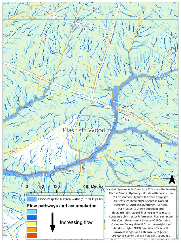
Introduction and project background
In 2012, the Sussex Wildlife Trust, the Environment Agency and the Woodland Trust began an
innovative project on the River Ouse in East Sussex, called the Sussex Flow Initiative (SFI). The project
aims to investigate ways that catchment-wide Natural Flood Management can help to reduce and
delay flood peaks in areas vulnerable to flooding, whilst increasing biodiversity and providing multiple
benefits at a landscape scale.

The Sussex Flow Initiative helps to develop new approaches to Natural Flood Management (NFM)
across the 672 km² area and 1220 km of river in the Ouse catchment, and makes recommendations
on how and where to target them. We are a pilot project to gauge the potential benefits of a wide
range of NFM techniques in lowland UK rivers, delivering NFM measures in partnership with
communities and landowners. We aim to demonstrate a best practice approach to NFM that can be
followed by other organisations beginning to embrace the approach.

One of the key targets of SFI is to promote and integrate a holistic approach to water and land
management across the catchment, and to make the catchment more resilient to flooding and
drought, through a combination of demonstration and advocacy. Although the effects of NFM such
as tree planting can take time to show their benefits, multiple actions taken now can provide positive
natural capital benefits in the long term. We hope to inform people about the natural capital benefits
of NFM, so that society can make the best choices for present and future generations.

This report provides a summary of the achievements of the SFI project over the last year (2018-2019).
We hope that the information helps to provide further evidence of the opportunities for future work
in lowland Natural Flood Management.

                                                    4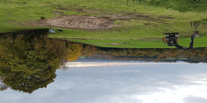
Project achievements 2018 – 2019
The Sussex Flow Initiative provides working examples of NFM techniques and best practice Natural
Flood Management projects. We promote a landscape scale approach to reducing flood risk and
water shortages, and to promoting the wider uptake of NFM in other suitable catchments.
Practical Delivery
Over the past year SFI has delivered a number of NFM projects, demonstrating a range of different
NFM techniques. These provide case studies and working examples of how NFM can be practically
applied in lowland catchments. The NFM methods we use include:
Planting of woodland and hedgerow, including across slopes and on floodplains
Restoring and reconnecting river channels, meanders and floodplain washlands
Using and managing woody material in watercourses to slow down flood flows
De-gripping of heathland, woodland and other land
Exposing and blocking land drains to slow the flow of water from farms
Increasing surface water storage (e.g. offline ponds and Run-off Attenuation Features)
Providing advice on land use and controlling excessive run-off and erosion
Promoting swales, permeable surfaces and rain gardens to capture and store run off
Woodlands and hedgerows
5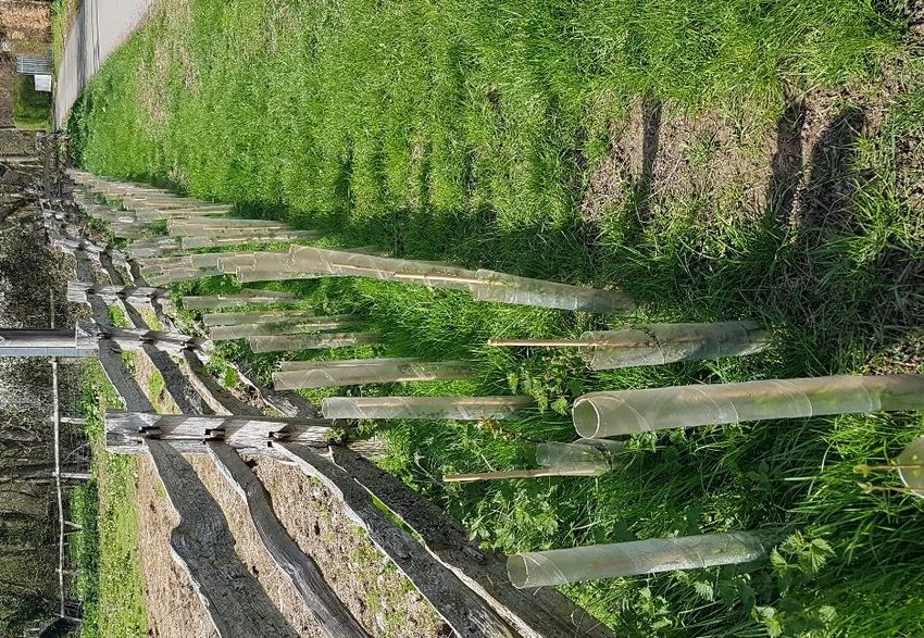
Woodland and hedgerows
Planting trees in the right places can provide many benefits including helping to slow the movement
of water through the landscape, enhancing ecological networks and providing shelter for livestock.
Floodplain woodlands, cross-slope hedgerows and shelterbelts physically intercept surface run-off
and floodwater whilst increasing water infiltration and percolation into soils and groundwater,
meaning that water reaches the catchments streams and rivers much more slowly. Due to variations
in topography, soil characteristics, root depth and morphology, there is no definitive figure of the
contribution that trees make to NFM. However, infiltration rates have been shown to increase by 5-
67 times1 in tree planted enclosures compared to grazed pasture, and surface run-off was shown to
reduce by up to 78% in two-year old tree planting plots in Pontbren, Wales2.

In the last year we have planted 10,650 native trees and hedgerow plants across four sites. This
includes 1.62 km of new hedgerow3 and 1.61 hectares of woodland, incorporating 360 m of cross-
slope hedgerows, 0.53 hectares of floodplain woodland, and 150 rare black poplar trees.

We have also advised and assisted landowners with Countryside
Stewardship (CS) applications, with two landowners (covering
150 ha of land) successfully entering into stewardship. CS
provided funding for hedgerows (500 m [2500 shrubs] planted in
2018/19 – not included in the above SFI figures) and fencing for
0.85 hectares of natural regeneration/scrub development on the
Cockhaise Brook floodplain.

We are experimenting with alternative ways to create woodland
and hedgerows without the need for plastic. We’ve created two
fenced (three strands of barbed wire) trial plots of approx. 0.1 ha
in total, where trees are planted without individual protection.

    Figure 1. Riparian planting (above), cross-slope hedgerow (top-right) and cross-slope woodland (bottom-right) planting

1
  Healey et al., 2016. Trees, water storage and flooding in upland agricultural landscapes. Forest and Timber News.
2
  Healey et al., 2016. Trees, water storage and flooding in upland agricultural landscapes. Forest and Timber News.
3
  Or over 5 hectares if counted as woodland at 2.5m spacing.

                                                                   6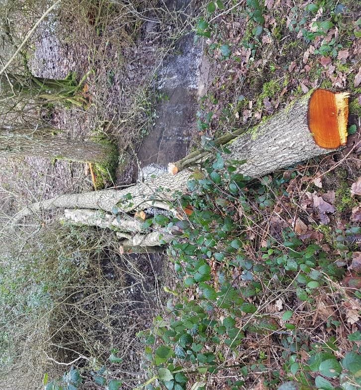
Floodplain washland storage
Floodplains offer fantastic opportunities for Natural Flood Management. When there is good
connectivity between a river and its floodplain, the floodplain provides temporary storage for large
volumes of water during a flood. Unfortunately the majority of rivers in the Ouse catchment have
either official (flood defences) or unofficial levees/embankments which prevent the river from
interacting naturally with its floodplain. The unofficial embankments are the result of spoil building
up over decades of dredging and other river management. By removing small areas of the unofficial
levees, the frequency of floodwater leaving the channel during flood events can be increased, whilst
also allowing floodplains, once flooded, to drain freely once the flood has receded.
Once floodwater is out of the channel and on the floodplain, the greater surface area and vegetation
‘roughness’ reduces water velocity and contributes to lowering and delaying the flood peak
downstream. In addition, slowing down floodwater helps to drop silt and other flood debris out of
the water column, naturally fertilising floodplain grasslands and helping to retain good soil structure.
By creating seasonal scrapes on floodplains, the water storage capacity is increased further, and
temporary freshwater habitat is also created, which is important habitat for a variety of aquatic
invertebrates, birds, amphibians, and other wildlife.
In the past year we have:
Created three (0.1 ha) floodplain scrapes which have increased the water storage capacity of
the floodplain by approximately 400,000 L.
Lowered unofficial embankments at three locations along the Cockhaise Brook, reconnecting
the floodplain and opening up approximately 1.3 ha of additional washland storage (storing
~2,600,000 L of water at flood depths of 0.2 m).
Advised a number of other landowners on the importance of river-floodplain connectivity, the
potential for lowering river embankments and the creation of floodplain scrapes.
7
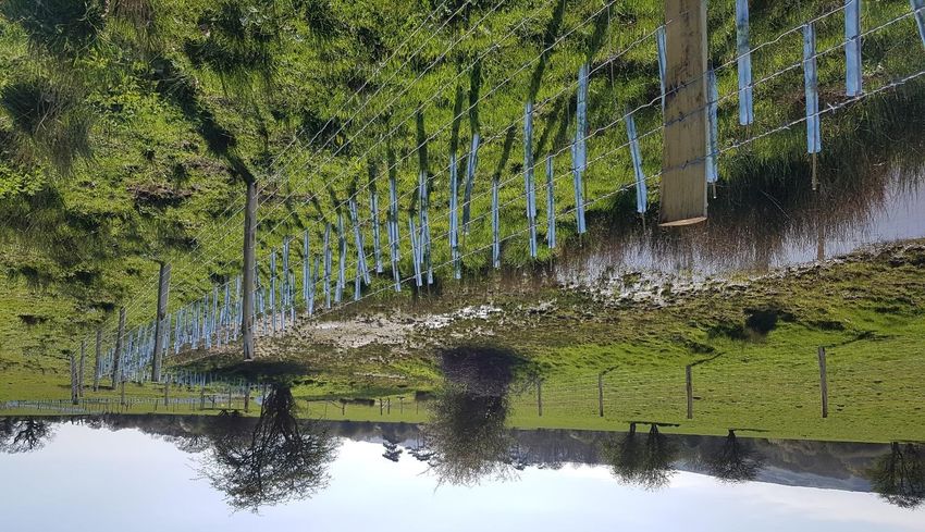
Figure 2. Cutting through main river embankments [left] and an adjacent floodplain scrape [right]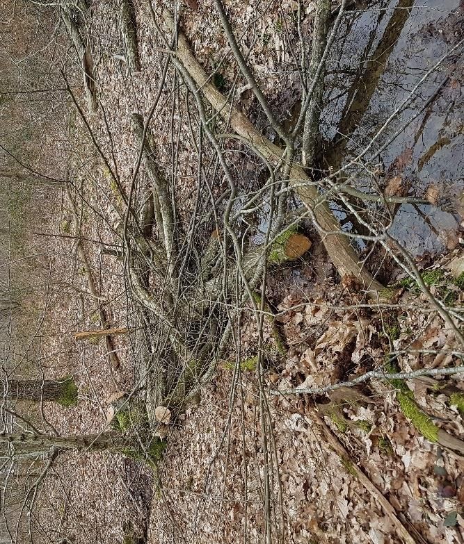
Scrapes, ponds and temporary flood storage
In the right places, temporary ponds/scrapes and silt traps can contribute significantly to flood risk
reduction downstream, and provide multiple other benefits to wildlife and society, such as reducing
pollution inputs to rivers.

This year, the Sussex Flow Initiative has created 15 (totalling 0.13 ha) scrapes in areas of semi-
improved grassland. By intercepting/blocking land drains, we ensure that water is temporarily stored
during heavy rainfall, rather than being rapidly transported down land drainage pipes and into nearby
watercourses. These scrapes are estimated to store approximately 600,000 L during flood events.

SFI also created one large sediment trap at the bottom of a large arable field, with the capacity to
store 90,000 L of water. The sediment trap is constructed in a way that allows a tractor to periodically
scrape out and recycle the eroded soil.

We have also advised numerous landowners on the creation of other seasonal water storage areas,
and the importance of temporary ponds.

 Figure 3. Seasonal water storage and land drainage work: Scrape intercepting land drain [top left], land drain [top
                       right], sediment trap [bottom left], exposed land drain [bottom right]

                                                           8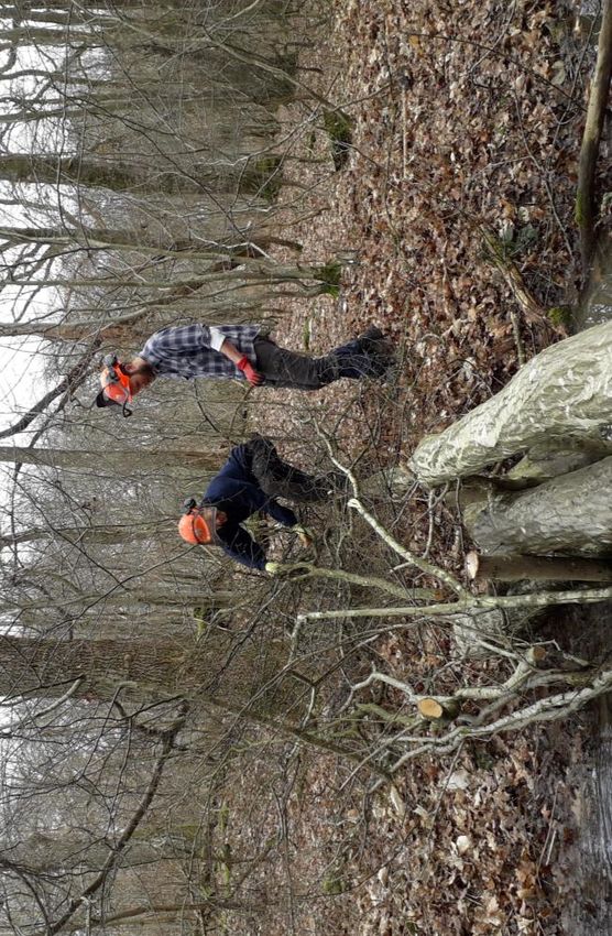
Large Woody Debris
By strategically introducing Large Woody Debris
(LWD) into streams and ditches, floodwater can
be intercepted during heavy rainfall events.

LWD helps to slow the speed of water,
temporarily backing it up and encouraging it out
onto small floodplains, where greater surface
roughness results in slower flows, as well as
more infiltration of water into soil and
groundwater.

We need to be careful where we place wood in
rivers, so that it doesn’t back water up and cause
floods where we don’t want them, but in
woodlands and other habitats away from
infrastructure, it is often easy to find areas which
can store water.

Sussex Flow Initiative has experimented with a
wide range of different natural woody
structures, to show how they slow and
temporarily store floodwater. In 2018/19 we
installed over 90 leaky dams, estimated to be
storing around 1 m³ (1,000 litres) of water per
structure during each rainfall event – or at least
90,000 litres of water.

Funding from Banister Trust allowed our Project
Officer to obtain chainsaw training, and purchase
the equipment needed to deliver larger and
more naturalistic LWD (Figure 4). In addition, we
provided training to two local arboriculturists at
Dryad Tree Specialists, who aim to deliver LWD
work throughout Sussex and Surrey.

We continue to work with the University of
Brighton, Queen Mary University of London and
others to learn how LWD influences stream flow,
flood      storage,  sedimentation,     channel
geomorphology, riparian soil moisture and plant
                                                Figure 4. Leaky dams holding back water in woodland ditches
diversity.
                                                                          and streams

                                                       9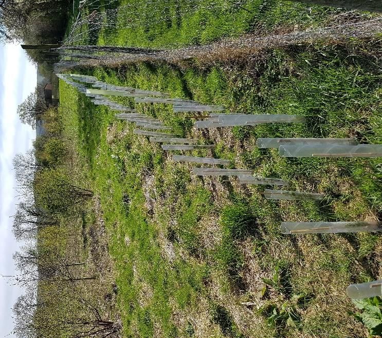
Subcatchment mapping
To identify the most effective places to use Natural Flood Management in the Ouse catchment, we
are working with the Ouse and Adur Rivers Trust to map and survey the River Ouse sub-catchments.
This year we produced a report for the Longford Stream sub catchment. The report uses Geographic
Information Systems (GIS) data, including the Environment Agency’s ‘Working with Natural
Processes’ evidence base, along with walk-over surveys, to identify and highlight the opportunities
for NFM and other habitat enhancements in the sub-catchment.

We also provided two short NFM reports to Lewes District Council; on the two sub-catchments which
encompass Ringmer Village and Broyleside, and on Meeching Valley in Newhaven. These reports aim
to identify natural opportunities to help reduce flooding in these areas.

Benefitting properties at ‘very significant risk of flooding’
The Environment Agency classify a property to be at very significant risk of flooding if it is in an area
at risk of flooding in a 1 in 20 year event. There are 25 such properties north of Lewes in the Ouse
catchment and the NFM work carried out by SFI in 2018/19 was upstream of 18 of these properties
(Figure 5; Appendix B).

   Figure 5. Overview of SFI’s activities and the properties at very significant risk of flooding in the Ouse catchment

                                                             10
‘Working with Natural Processes’ targeting
As part of the Environment Agency’s evidence base for NFM, their ‘Working with Natural Processes’
(WwNP) resources include a series of GIS layers highlighting NFM target areas identified through
detailed modelling. These map layers released in October 2017, are now being used to assist with
the targeting work of SFI (Figure 6).
Comparing SFI’s delivery of Natural Flood Management in 2018-19 (targeted and organised before
the release of the evidence base) retrospectively to the WwNP layers, shows that our prior targeting
and delivery of tree planting somewhat aligns with these layers. For example 476 m of hedgerow is
planted in areas identified as a WwNP target area for riparian planting, floodplain or wider catchment
planting. Similarly, 0.7 ha of SFI-planted woodland is located in a WwNP target areas for planting.
The WwNP layers will prove useful in assisting us to target landowners, however it is also necessary
to work opportunistically and to ground-truth these models to ensure that local opportunities are
not being missed or wrongly identified.
Figure 6. EA Working with Natural Processes tree planting target areas in the
Ouse catchment
11Surface water flow paths mapping
By the time flood water reaches our main streams and rivers, it is often too late to prevent a flood.
NFM measures can help by slowing and reducing the amount of water that reaches our watercourses
during and after heavy rainfall, helping to reduce the impact of floods.
For our Natural Flood Management measures to work, we need to know where we can intercept
surface water run-off effectively. This might include dips and hollows in the landscape which are dry
for most of the year, or entire field slopes, which transport water rapidly during heavy rainfall events.
This year we created the Surface Water Flow Path map using LIDAR and ARCGIS, which shows us
where and how much water flows through the landscape (see example in Figure 7). Used in
conjunction with the freely available Flood Maps for Surface Water, we can strategically place our
large woody debris structures and other NFM measures in the path of surface water flows which
would otherwise contribute to local floods.
Figure 7. Example of a flood map for surface water and flow pathway map
12Catchment-wide influence
Quantifying the effects of catchment-wide NFM interventions on a flood hydrograph is a challenging
task, partly due to natural variability in precipitation over space and time, and variations in land
cover/use.
This year, SFI has worked instream, and in riparian and floodplain areas, as well as throughout the
wider catchment, positively influenced over 420 hectares of land for NFM (advice given to
landowners of 2,460 hectares). Of this land, approximately 29 hectares (151 hectares if including
advice given to landowners) is floodplain (Flood Zone 2). We have actively influenced at least 4.5 km
of the river network using instream work4, at least 10 km through land-based activities5, and
potentially over 96 km by providing advice on land and habitat management6.
The Sussex Flow Initiative has contributed to the restoration/creation of 7 hectares of priority habitat
(6.7 ha of woodland7 and 0.3 ha of open/standing water) this year. Through collaborating with
external organisations (e.g. Catchment Sensitive Farming) we have supported landowners and
contributed to Countryside Stewardship applications, with two of these landowners entering into
stewardship in 2018/19.
Figure 8. Countryside Stewardship-funded hedgerow and fencing,
alongside scrapes and re-instated stream channel delivered by SFI in 2017/18
4
Based on an estimated 50 m of influence per woody structure
5
Only including waterbodies downslope and adjacent to tree planting (i.e. not including downstream effects)
6
Including a 100 m buffer of landowner boundaries
7
Including hedgerow (320 m of hedgerow is equivalent to 1 Ha of woodland in terms of number of trees/shrubs
planted)
13Providing ecosystem services through Natural Flood Management
One of the most important features of natural flood management is that it delivers flood benefits, as
well as other multiple benefits for both the environment and people. Not only do NFM measures
help to reduce flood risk and increase drought resilience, but they also provide a whole range of other
natural goods and services (see Appendix C) on which society rely. This includes provisioning,
regulating and cultural ecosystem services:
Provisioning services
Biodiversity: Woodlands, hedgerows, open water features and wetlands provide important
habitat and food resources for a range of wildlife. Our work helps to improve the
connectedness of local and regional habitat through enhanced ecological networks, and
therefore the resilience of species to climate change. Rare, native tree species have been
planted, adding to the potential genetic diversity and natural survival of these species.
Shelter: Hedgerows and woodland areas provide shelter for livestock from rain, wind or sun,
which is an important aspect of animal husbandry (Figure 9).
Timber and fuel: The woodlands planted by SFI comprise numerous species with a tradition
of coppicing (e.g. hazel, sweet chestnut, field maple, oak), and can be managed to provide a
renewable source of timber or fuel.
Food: Hedgerows and woodlands are an important source of fruit, nuts and berries for people
and a range of wildlife. Improved in-stream habitat, reduced sedimentation and increased
natural shading helps to ensure healthier populations of fish by buffering climate change
impacts, and improving fish spawning habitat. Hedgerow forage can be an important source
of food and natural medication for farm livestock.
Figure 9. Shelterbelt floodplain woodland planting at the Sussex Horse Rescue Trust (left)
and hedgerow at Macs Farm (right)
14Regulating services
Pollination: Hedgerows and shaws have been planted using > 10,650 native flowering trees
and shrubs, with > 800 of them planted in Buglife’s B-line pollinator corridors, providing a
food source for a range of pollinators. A further 2,500 shrubs were planted through CS
applications we helped to support.
Carbon Sequestration: Every year, until they are mature, the equivalent of 6.7 hectares of new
woodland/hedgerow will be providing carbon sequestration, with a predicted total of up to
92 tonnes of carbon dioxide-equivalent per year.8
Water purification: We have provided advice on land adjacent to > 7.5 km of watercourse
failing to meet Water Framework Directive (WFD) environmental quality standards for
phosphorous. This has included advice on measures to reduce surface run-off and soil erosion,
and riparian buffer strips, which in turn help to reduce phosphorus delivery to these
waterbodies.
Water storage & flood regulation: Using flood storage ponds, de-gripping, seasonal water
storage and woody structures, we have created up to 3,780,000 litres of additional flood
storage per flood event. Our NFM delivery has taken place upstream of 18 properties (north
of Lewes) considered to be at “very significant risk” of flooding, according to the Environment
Agency. Advice on flood water storage has been given following 38 site visits, with these sites
being upstream of 18 properties (north of Lewes), and in close proximity (< 150 m) upstream
of three of the properties considered by the Environment Agency to be at “very significant
risk” of flooding.
Soil erosion and health: Hedgerows and woodlands help to break up compacted soils, allowing
them to hold more water. The root structures associated with them help water to penetrate
into the soil more readily. They also help to reduce erosion by wind and water. Less intensively
managed grass and woodland habitats support healthier populations of earthworms,
beneficial bacteria and mycorrhizal fungi, which in turn increase soil structure, health and
porosity.
Pollution regulation: Hedgerows & woodlands provide buffers to roads with benefits to air
quality and local noise reduction. NFM measures & natural habitats also help to buffer, reduce
and break down water pollution.
Figure 10. Floodplain scrape with adjacent tree planting
8
Natural England. Carbon Storage by Habitat: 13.7 tCO2-e ha-1 yr-1 sequestered when land is changed from improved
grassland to woodland (year 2 – 21)
15Cultural Services
Cultural benefits: SFI has supported the River Ouse Meadows Project to protect culturally
important meadow landscapes. We work with the High Weald Area of Outstanding Natural
Beauty and support the work that they do to conserve traditional landscapes.
Human health: We provide advice, support and funding to local communities, helping to
create a more connected and diverse landscape with corresponding benefits to human health
and welfare. Our river habitat / leaky dam workshops, and our tree planting, provide hundreds
of people with opportunities to engage positively with the outdoors, supporting physical and
mental health improvements, and increasing connection with nature.
Connecting people with their local environment - recreation and aesthetic experiences: Many
of the hedgerows and woodlands are adjacent to, or in close proximity to public rights of way,
ensuring that these features can be appreciated by a large number of people.
Restoring historic landscape features: Hedgerows have been a part of the British landscape
for centuries, and are iconic features of rural areas. By planting hedgerows and woodland in
areas where they were previously located, SFI are contributing to the
conservation/restoration of rural landscapes and heritage in Sussex.
Figure 11. Floodplain hedgerow alongside a road (left) and hedgerow alongside a bridleway (right)
16The multiple benefits of different Natural Flood Management measures are well documented in the
Environment Agency’s ‘Working with Natural Processes’ evidence base. This includes ‘benefit wheels’
for a wide range of techniques. Examples of these are shown below in Figure 12.
Figure 12. Multiple benefits provided by Natural Flood Management techniques (EA, 2017)
17Engaging and supporting local communities
A core role of the Sussex Flow Initiative is to support local people to take positive action to help
reduce flooding in their local communities. We do this in a range of ways including working with local
flood groups, training local people in NFM delivery, and educational events and websites. Our
advocacy work involves engagement with landowners, local district councils, county councils, the
Environment Agency, NGO’s and many more:
Landowners
This year we visited 30 landowners on 38 sites, covering over 5.6% of the land upstream of
Lewes, on a total of at least 2,457 hectares of land (3 hectares downstream of Lewes).
Of these 38 sites, 14 included floodplain areas on ‘main river’ or ‘ordinary watercourses’.
For a map showing the extent of the land that we advised over the last year, see Appendix A.
Contributing to the evidence base
The Sussex Flow Initiative continues to work with academics and students from universities, assisting
with their research into aspects of NFM including:
Design of coarse woody material structures and their influence on channel flow and
geomorphology
Modelling of hydrological processes including surface water flow and groundwater flow
18We have worked with, and been supported by other national flagship NFM projects including the EA
Working with Natural Processes (WwNP) and Stroud Rural Sustainable Drainage project (RSuDS).
We have also worked with local ecologists to gain baseline data on site biodiversity to monitor spatial
and temporal changes following the installation of NFM measures.
Flood risk agencies and organisations
Sussex Flow Initiative works closely with Lead Local Flood Authorities (LLFA) and others who have a
statutory duty to prevent flooding of residential properties, businesses, and infrastructure. By
engaging with these groups, SFI is directly influencing the future of (natural) flood management, and
increasing the likelihood of sustainable flood risk management approaches being embraced. We have
engaged with the following flood authorities and groups over the last year:
Lead Local Flood Authorities; Flood and Coastal Risk Managers;
Lewes District Council; Planning Authorities;
East Sussex County Council; DEFRA
Regional Flood and Coastal Committee; Local Flood Action Groups
Working in partnership
Over the last year we have hosted visits by DEFRA, Wessex EA, the Woodland Trust and East Sussex
County Council.
SFI has provided information and expertise to other projects and in other policy areas including:
Powdermill NFM project,
Vert Woods Community Woodland
Gatwick Greenspace
RSPB
National Trust
Wallington NFM project (Hampshire)
Aldingbourne NFM project
Cuckmere valley
Draft guidance on national floodplain wetland mosaic proposals
Brighton and Hove SUDS planning document
19We have worked with a range of local and national groups and stakeholders including:
Working with local communities
An important benefit of NFM is its ability to empower local people to increase the resilience of their
communities to flooding. Through volunteer tree planting days at the Sussex Horse Rescue Trust
(Uckfield) SFI has connected with local people giving them an opportunity to take positive action to
reduce flood risk, providing information on the projects objectives and the theory behind NFM. Our
leaky dam days have also helped to give others more confidence in NFM delivery.
We also work with a number of Catchment Partnerships and others to encourage wider uptake of
NFM.
20Events
To disseminate the experiences and findings of SFI, we have presented at national and local events
including:
EA Regional WwNP conference
Adur and Ouse Catchment Partnership
Wivelsfield Parish Council meeting
Sussex Horse Rescue Trust summer fair
Tingles Way guided walk
Natural England LWD day (Knepp)
Other Public talks
Hants Wallington talk
Through these events we have reached an audience of at least 600 people.
Training and signposting
By providing information to a variety of organisations, and by training contractors and staff (Figure
13) who work across Sussex and beyond, SFI has facilitated the uptake of NFM approaches both
within the project area and further afield. For example, we hosted a visit by NFM project coordinators
from Wessex EA, visiting our NFM demonstration sites and sharing our experiences.
We also trained two arboriculturists from Dryad Tree Specialist in the installation of LWD in streams
and have worked with Wild Sussex to deliver naturalistic land-based NFM. We are also working
closely with Catchment Sensitive Farming Officers to share best practice NFM implementation for
water quality as well as flood risk management.
Figure 13. Woodland Trust staff being trained to install LWD
21Volunteers & ‘in kind’ support
An important aspect of NFM is the ability to empower communities to actively increase their
resilience to flooding. Without the support from local communities, landowners and volunteers, the
delivery of NFM in the Ouse catchment would be significantly reduced. In 2018/19 we received huge
support from a team of dedicated and enthusiastic volunteers from local communities, project
partners, and other stakeholders (e.g. water companies, local companies). This included:
More than 300 volunteer hours from more than 40 volunteers, with a value in excess of
£40009
Volunteers from the Environment Agency’s operational teams
Our main partner organisations contributing around £37,000 of their time ‘in kind’10
Landowners contributing at least £27,000 towards contractors, materials, and ‘in kind’
Funding from external sources (i.e. Banister Fund) of £48,000
Figure 14. Volunteers from stakeholder groups (Environment Agency [top left], local companies and residents [top right],
and Woodland Trust staff [bottom])
9
Based on £100 per day for volunteers
10
Based on Woodland Trust, EA, Sussex Wildlife Trust & Sussex Biodiversity Records Centre including comms support
22Websites and social media
The Sussex Flow Initiative continues to build its online presence by maintaining a comprehensive
website and blog, as well as a Sussex Wildlife Trust SFI page, and social media/networking accounts.
In the past year, the SFI website has had 1300 unique visitors, with 125 and 75 reading our blogs and
case studies, respectively. Sussex Wildlife Trust pages attracted over 500 views throughout the year,
and the SFI twitter and Facebook posts have been viewed more than 155,000 times and have resulted
in >3,300 interactions.
In addition to written outputs, we have uploaded videos of tree planting and woody debris dams to
YouTube, which have received more than 600 views in the past year.
Case studies
To encourage the uptake of a wide range of NFM techniques, SFI has produced some introductory
case studies that will act as a useful resource for organisations new to NFM, those wishing to explore
new techniques, and those interested in finding examples of collaboration, funding and NFM
delivery. To date, there has been little information available on utilising NFM in lowland catchments,
so these case studies can provide organisations working in catchments with similar characteristics,
with examples of how NFM can be used in such situations. These case studies include using leaky
dams in woodlands, woodland and hedgerow planting, and whole farm NFM.
23Print Media
A number of articles have been published in magazines and newsletters, including the Nation Farmers
Union South East Magazine (readership of > 5000), and in the Catchment Sensitive Farming
newsletter.
We have also provided advice and text for a self-guided walk (Figure 15) around the Lewes area that
is set to become an offshoot of the South Downs Way, and will be publicised during the Eastbourne
and Lewes walking festival.
Radio
Sussex Flow Initiative was interviewed on Radio Uckfield during the Sussex Horse Rescue Trust
summer fair about the aims of the project and need for local volunteers.
Figure 15. Articles published in the NFU South-East Magazine (top) and the Tingles Way flyer on NFM and SFI (bottom)
24The future of Natural Flood Management and the Sussex Flow Initiative
This year, the Environment Agency launched a National Programme of NFM, which SFI will be helping
to inform, support and deliver. We are pleased that this milestone has been reached, and that Natural
Flood Management has been accepted nationally as one of the primary means to achieve sustainable
flood and water management. We will be helping to train and upskill as many people as we can in
NFM measures and how to apply them in an informed and effective way.
Over the coming years we will remain focused on delivery and advocacy and have set out ambitious
targets for the future of SFI in our five-year vision document. During 2018/19 we have made
significant progress towards many of these targets (see Appendix D).
We are excited to further engage with the local communities in the Ouse catchment, and expand our
volunteer base, ensuring that we continue to step up the delivery of NFM throughout the catchment.
We will continue to strive to provide best practice examples of NFM in lowland catchments, foster
collaboration with a variety of stakeholders, and maximise the dissemination of our work.
25Appendices
Appendix A. Landowner visits 2018/19
26Appendix B. Properties at very significant risk of flooding and their catchments in
the Ouse catchment north of Lewes.
27Appendix C. UK NEA services provided by the 3 main strands of SFI Project work
ES from SFI ES from SFI
ES from SFI
Ecosystem service Semi Nat Fresh & Open waters,
Grasslands / Woodland Wetlands &
Washlands Floodplains
Food ● ● ●
Water ● ● ●
Timber ● ●
Wood fuel ●
Biofuel (incl. Peat)
Bioenergy
Health Products
Fibre ●
Species Diversity ● ● ●
Genetic Reserves ● ● ●
Disease and Pest Control
Climate Regulation ● ● ●
Erosion Control ● ● ●
Water Regulation ● ● ●
Flood Regulation ● ● ●
Fire Hazard Regulation
Air Quality Regulation ● ●
Water Quality Regulation ● ● ●
Soil Quality Regulation ● ● ●
Noise Regulation ●
Recreation ● ● ●
Tourism ●
Aesthetic Values ● ● ●
Cultural Heritage ● ● ●
Employment ● ● ●
Spiritual Values ●
Education ● ● ●
Sense of Place ● ● ●
Health Benefits ● ●
Navigation
TOTAL 20 21 18
Appendix D. Sussex Flow Initiative five-year targets
28Five-year targets (2017 – 2022) Progress towards target in 2017 – 2019
High level targets
In the long term (10 years +), to influence at least 20% of the > 25.5 km of river/stream influenced (>130.4 km
catchment (13,430 ha) and to support the creation of 40% woody potentially influenced by advice given)
cover in the upper third of the catchment, and 20% woodland cover
in the central third of the catchment and/or influence 20% of river Advice on 3038 ha of land, delivery on 922 ha.
length (240 km)
Aim to show a reduction in peak flows from intense rainfall events 18 properties at very significant risk of flooding
with a subsequent reduction in risk to existing properties in flood are downstream of NFM measures we have
risk areas. Working from baseline hydrometric data (where implemented
available), work with EA to seek to quantify the reduction in flood
flows and risk to existing properties
Aim to show a positive influence on water quality / WFD failing Advice given to landowners adjacent to > 11 km
waterbodies of river/stream failing to meet WFD targets for
phosphorous
Habitat Delivery and NFM
At least 100 Large Woody Debris (LWD) dams installed 137 woody material structures installed
1,500,000 litres of additional seasonal water storage created Between 4,098,200 L and 5,098,200 L
created
Reconnected floodplain able to store
2,600,000 L
Scrapes storing 1,270,000 – 2,270,000 L
Sediment trap storing 90,000 L
LWD slowing approx. 137,000 L
1200 L stored in pocket ponds
25 ha of priority habitat created including : 18.5 ha of priority habitat (if hedgerows counted
as woodland):
Minimum 10 ha woodland planting and 3.38 ha of woodland created
Minimum 10 km hedgerow planting 4.59 km of hedgerow planted
Open water – 15 ponds enhanced / restored and/or 10,000 m² At least 7500 m2 of seasonal open water
of open water created created
Strategic and Catchment Scale
Two sub catchment plans written One full sub catchment plan (Longford Stream)
and one short sub catchment report (Ringmer)
written
At least one sub catchment plan implemented
Flagship projects funded and initiated with EA, RFCC and at least
one new Lead Local Flood Authority
At least 30 people trained and upskilled in NFM techniques via river Training of 12 contractors and staff - digging
habitat workshops, staff training days, new comms/events wildlife scrapes, ponds and installing woody
material
A further 15,000 tonnes of potential carbon storage created Approximately 242 tonnes of carbon storage per
year (after year one) created by hedgerow and
woodland planting
29Natural capital and multiple benefits of the work we have achieved Case studies and blog posts have been
clearly articulated for all produced, highlighting the multiple benefits that
SFI activities will result in
At least 10 external sites supported to carry out additional NFM
works
Engagement and Advocacy
Engagement and influence of at least 5,000 people Potentially >355, 00011 people reached with
varying levels of engagement and influence.
High level engagement includes community
engagement with >155 volunteers, >700 people
at conferences and local events, >2800 views to
SFI articles/web pages. >500 views of SFI-related
pages on SWT website and >4300 interactions
on twitter and Facebook
At least 10,000 ha of land advised and engaged with on NFM > 4,360 ha of land advised
At least 20 events held or SFI represented Eight events; (CIWEM conference; WwNP event,
Adur and Ouse Catchment Partnership, Lewes
Tree Charter, Arun Valley Vision Group,
Transition Town Worthing, SHRT summer fair,
Tingles Way guided walk)
At least two advisory leaflets written and published
Publish information (TV, radio, external websites) which reaches Reached an audience of approx. 169,000, plus a
potential audiences of at least 100,000 radio interview on BBC Sussex which has weekly
listener numbers of > 260,000
Publish at least five case studies / National Guidance Documents on Three case studies have been produced
the work that we have achieved highlighting project work
Budget and Finance
Attract at least £200,000 of in kind funding At least £125,250 (£68,000 in 2018/19) of in kind
funding
Generate at least £50,000 of further income £47,984 grant received from Banister Fund
£17,700 Woodland Trust planting and fencing
Additional £3,424 LDC funding
Evidence and Research
Generate a legacy of experimental research projects with key
universities, CABA (Catchment Based Approach), the Environment
Agency and others; at least 5 research projects supported
Work with existing organisations who can assist with long term
monitoring (e.g. Rivers Trusts)
Others we have influenced to deliver KPI’s Woodland Trust
Influence at least ten others to deliver on KPI’s Forestry Commission
East Sussex County Council
Lewes District Council
Adur & Ouse Catchment Partnership
Esus Forestry
11
Including 37,000 listeners to the radio interview (260,000 weekly listeners divided by seven days)
30Dryad Tree Specialists
Tilhill Forestry
Strutt and Parker
31You can also read