South High Street Corridor Plan - DRAFT - West Chester Borough
←
→
Page content transcription
If your browser does not render page correctly, please read the page content below
DRAFT

South High Street Corridor Plan
A Blueprint for Safety and Corridor Transformation

                                                     Traffic Planning and Design

        10-8-2020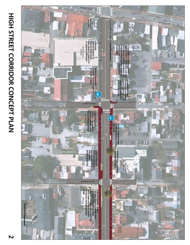
South High Street Corridor Plan
    This corridor study, with funding from the Chester County’s Vision Partnership Program, provides a long-term planning blueprint for safely
    accommodating all users of High Street in the Borough of West Chester, Chester County, PA. This plan is intended to serve as a resource to
    West Chester Borough, West Chester University, PennDOT, SEPTA, and all corridor stakeholders to guide the improvement and transformation of
    South High Street.

    PROJECT SPONSOR
    West Chester Borough
    401 E. Gay Street
    West Chester, PA 19380

    FUNDING PROVIDED BY
    Chester County Vision Partnership Program

    CONSULTANT
    Traffic Planning and Design, Inc.
    1025 Andrew Drive, Suite 110
    West Chester, PA 19380

1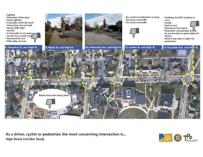
STEERING COMMITTEE MEMBERS:
Mike Perrone, West Chester Borough Manager

O’B Laing, West Chester Borough Public Works

Kevin Gore, West Chester Borough Planning and Zoning

Sgt. Chris Daly, West Chester Borough Police Department

Scott Bohn, West Chester Borough Police Department (retired)

Kevin Myers, Chester County Planning Commission

Mason Gilbert, Chester County Planning Commission

Mark Cassel, SEPTA

Matthew Anderson, PennDOT District 6-0

Vince Cerbone, PennDOT District 6-0

Bradley Flamm, West Chester University

Dr. John Villella, West Chester University

                                                               2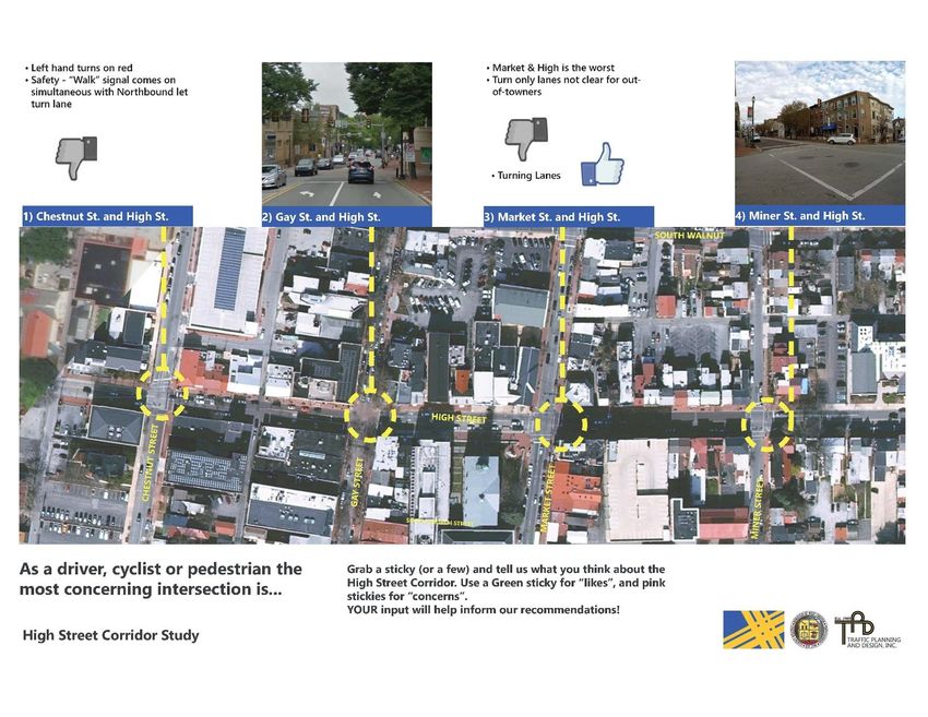
CRAFTING A CORRIDOR PLAN FOR HIGH STREET

    As the primary north-south roadway connecting downtown West Chester to West Chester University,
    High Street is a bustling corridor for all modes: cars, trucks, buses, pedestrians, and even bicyclists. An
    average of 14,000 to 17,000 vehicles a day traverse the blocks of South High Street, two SEPTA bus routes,
    countless pedestrians, and a small number of bicyclists -- whether on-road or on the sidewalk. At
    approximately 34 feet across curb-to-curb, High Street (a PennDOT-owned roadway) shoulders a
    significant demand for space, accommodating on-street parking for businesses and residents and much-
    needed left-turn bays at signalized intersections. Perhaps due to all these demands, South High Street
    doesn’t have quite the “polish” or cohesiveness that North High Street or Market Street or Gay Street
    enjoys. South High Street today has more grit than polish. The distinctive brick sidewalks – iconic of West
    Chester – have been disrupted by mature trees or replaced entirely with less-distinct concrete sidewalks.
    For all of its busyness and pedestrian activity (night and day), High Street today is sporadically and
    inconsistently lit. The corridor lacks ornamental street lighting (which is prevalent across the downtown
    business improvement) and intersection lighting – especially at its many crosswalks – doesn’t meet current
    lighting standards.

    Given the key role that South High Street plays in the fabric of West Chester, this corridor plan seeks to
    develop a cohesive vision and blueprint for improving South High Street. It is a plan that will guide the
    efforts of the Borough, PennDOT, West Chester University, or any private redevelopment that is proposed
    in the future. Just as importantly, it serves as a plan that improves safety for all users: pedestrians, motorists,
    bicyclists, and transit riders and ultimately, a plan that transforms South High Street in a manner that aligns
    its form with its critical function.

3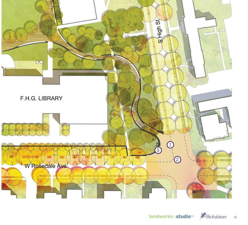
Figure 1: Study Context and Limits

                                     4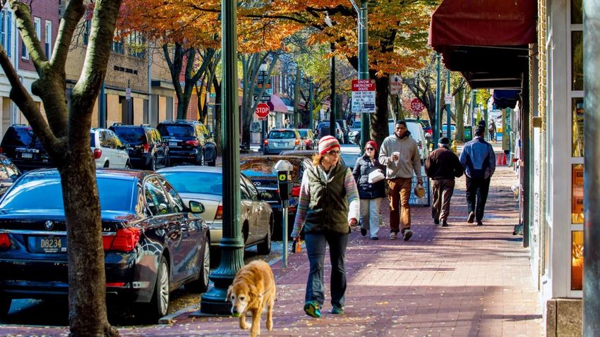
A PLAN FOR IMPROVING MULTIMODAL USER SAFETY
    The South High Street Corridor (Chestnut Street to Rosedale Avenue) experienced 138 reportable crashes between 2014 and 2018. Over this five-
    year period, one-quarter of these crashes (34) involved a pedestrian. Therefore, a primary focus of this Corridor Plan is to improve the safety of
    High Street for all users, modes, and abilities.

    KNITTING TOGETHER MULTIPLE PARTIES AND PROJECTS
    Prior to the commencement of this Corridor Plan, both West Chester Borough and PennDOT recognized the need for improving South High Street.
    Both agencies were pursuing funding to improve the Corridor. Additionally, West Chester University had completed its own campus master plan,
    which included recommendations for South High Street. Yet, in the absence of a cohesive corridor plan, these projects were being advanced
    somewhat independently of one each another without a consistent design palette or vision. Therefore, this Corridor Plan establishes the framework
    and vision for High Street. These projects – collectively a multi-million dollar investment in South High Street – provide an opportunity to immediately
    implement the Corridor Plan.

    Chester County Community Revitalization Grant
    Through the Chester County Community Revitalization Program (CRP), the Borough has secured $400,000 of funding to conduct improvements
    along High Street. West Chester Borough is matching this grant with $100,000 of local funding. According to the Chester County Community
    Development Department, the CRP program provides funding for infrastructure improvements, streetscape activities, economic development
    opportunities, and other projects that promote revitalization of Chester County’s urban centers. This will provide construction funding to complete
    a large part of the improvements recommended in this plan along the southern
    portion of High Street around the Campus area.

    PennDOT Highway Safety Funding
    PennDOT District 6-0 applied for design and construction funding through the
    Federal Highway Safety Improvement Program (HSIP) for the section of High Street
    between Rosedale Avenue and Miner Street. This section of roadway met the
    criterion to qualify for funding through this program as it contained several crash
    clusters, including pedestrian crashes, bicycle crashes, rear-end crashes, and other
    focal points of the program. PennDOT Central Office performed a statewide
    network screening analysis based on the Highway Safety Manual that goes beyond
    the number of reportable crashes to include speed limits, the number of travel lanes
    and several other factors. The High Street corridor experienced higher than
    expected crash rates based on other roads with a similar topology. While High
    Street does qualify for the HSIP program, it was not selected for funding through
    PennDOT’s statewide competitive funding application process to receive federal

5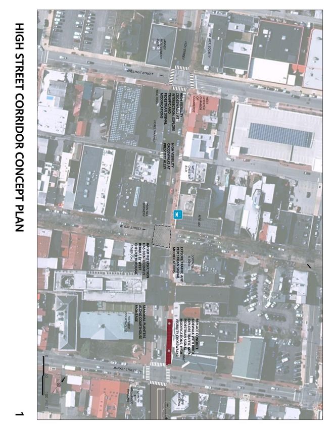
funding. PennDOT District 6-0 then applied to the Delaware Valley Regional Planning Commission (DVRPC) for regional HSIP funding through the
2021 Transportation Improvement Program. This project has been selected for funding by DVRPC for funding in the Fiscal Year 2021-24
Transportation Improvement Plan to receive a total of just over $1.8 million. This funding is to design and install streetscaping items, signalization
improvements, as well as provide lighting and pedestrian improvements along the High street Corridor.

West Chester University - Presidential Walk                     Figure 2: Concept plans for the proposed Presidential Walk
West Chester University identified a significant
reconfiguration to the pedestrian connection from the
Rosedale Avenue/High Street intersection to the academic
quad within the University’s Landscape Master Plan. The
concept, known as the Presidential Walk, also would
reconfigure the northwest corner of the High/Rosedale
intersection with the installation of new hardscaping and
a fountain feature. The University submitted land
development plans to West Chester Borough in Spring
2020 to advance this concept to construction. The
Consultant Team reviewed these plans and incorporated
these concepts into the overall Corridor Plan.

                                                                                                                                                         6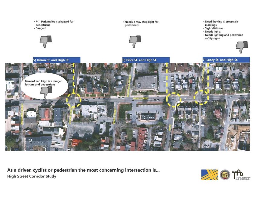
HIGH STREET - TODAY
        Existing Conditions

7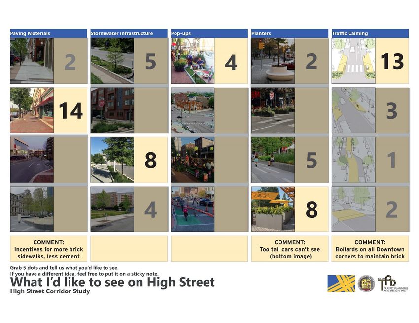
HIGH STREET - TODAY                                                      Chestnut Street                   Chestnut Street
High Street is the primary north/south roadway within West
Chester Borough. By connecting West Chester’s central business                 Gay Street                  Gay Street
district to West Chester University as well as hosting a mixture of
commercial businesses, High Street also functions as a “main               Market Street                   Market Street
street” corridor. When entering the Borough from the south,
specifically when traveling northbound on US 202, High Street
presents itself as a gateway to West Chester Borough.                       Miner Street                   Miner Street
High Street is a truly multimodal corridor. Several intersections
experience thousands of pedestrian crossings on a daily basis as          Barnard Street                   Barnard Street
university students, faculty, residents and business employees
traverse this corridor. In addition to serving vehicular and
                                                                            Union Street                   Union Street

                                                                                             High Street
pedestrian traffic, SEPTA bus routes 92 and 104 provide service
along the corridor. For a full summary of AM and PM traffic
counts see the Appendix.
                                                                             Dean Street
The “off-setting grid” of lower South High Street
                                                                                                           Magnolia Street
While much of the Borough’s street network follows a                  Price Street (PA 52)
conventional grid-pattern, South High Street between Dean
Street and Linden Street is laid out with an off-setting grid                                              Lacy Street
pattern – with South High Street serving like the seam stitching
together two different, off-setting grid networks. Most notably in       Sharpless Street
the context of this Corridor Plan, this off-setting street design
creates several unsignalized intersections where pedestrians                                               Nields Street
must cross High Street without the protection of a traffic signal.
This stretch of High Street also coincides with large
concentrations of off-campus housing; therefore, there are a
                                                                       University Avenue
large number of pedestrians traversing High Street.                                                        Linden Street
                                                                        Rosedale Avenue                    Rosedale Avenue

                                                                                                                             8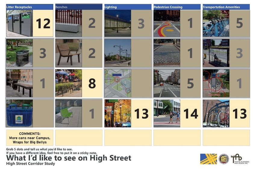
Pedestrian Activity
    To gain a better understanding of the corridor’s pedestrian activity, the Consultant Team collected 12-hour pedestrian counts at all intersections
    between Price Street and Rosedale Avenue. During the course of 12-hours on this late-spring weekday, over 10,000 pedestrian crossings of High
    Street were observed. Approximately half of the High Street crossings occurred at the signalized intersection of Rosedale Avenue.

    The intersection of High Street and Rosedale Avenue recorded almost 4,500 pedestrian crossings of High Street in a 12-hour period.

9
Figure 3: Weekday Pedestrian Crossings by Intersection/ Hour
High Street Corridor - Weekday Pedestrian Crossings by Hour
North
Price
South
North
Lacey
South
Sharpless
North
South
North
Nields
South
University
North
South
North
Linden
South
Rosedale
North
South
0 500 1,000 1,500 2,000 2,500
No. of Pedestrian Crossings
6:00 7:00 8:00 9:00 10:00 11:00 12:00 13:00 14:00 15:00 16:00 17:00
Pedestrian crossings chart (2019-11 Existing Counts Summary.xlsx)
10Transit Ridership Figure 4: SEPTA 104 Routing (Previous and Current)
Two SEPTA routes, the Route 92 and 104, operate along South High
Street. SEPTA’s Route 92 operates from Exton to West Chester to
Paoli/King of Prussia, while SEPTA’s Route 104 operates from West
Chester to Upper Darby. Until 2018, SEPTA’s Route 104 ran south along
High Street before turning onto Sharpless Street and then down Church
Street, with a main stop just south of University Avenue. Average daily
ridership from this service pattern is displayed in Figure 5.
Since Fall 2018, however, both routes run entirely along High Street
through the Study Area. From a transit perspective, these routing
adjustments further elevate the importance of High Street.
Unfortunately, in the present condition, there are no bus shelters or
other transit amenities (e.g. trash receptacles, next-to-arrive
information) along High Street.
Linden Street at High Street (NB) has become the main SEPTA 104 bus stop
since the 104 route was moved off of Church Street
11Figure 5: Average Daily Ridership - 2018
Note: numbers indicate combined boarding and departures. Based on SEPTA staff observations, the majority of boardings/alightings at the former University Avenue/Church
Street bus stop have moved to High Street/Linden Street.
12Lighting Conditions
The current lighting within the study area is
provided by a variety of pedestrian-scale and
traffic scale lights in a non-uniform
arrangement. The current lighting
arrangement leaves many zones along the
street and sidewalk illuminated to less than
recommended levels. The measurement of
the contrast between dark and light areas is
referred to as uniformity, which is measured
by comparing the maximum to minimum or
maximum to average luminance. Due to the
location and configuration of High Street, this
is considered to be a collector street with high
pedestrian volumes. In basic terms, the
higher the numbers of vehicles and
pedestrians, the brighter the street should be
illuminated at night. Intersections, bus stops,
and delineated pedestrian crossings should be
even brighter.
13Crash Analysis
The Consultant Team obtained all available crash data for the last five years (2014-2018) through PennDOT’s crash reporting system. Additionally,
the West Chester Borough Police Department provided data on non-reportable crashes and analysis. Collectively, the Consultant Team and
Borough PD identified areas of high crash clusters, as summarized in Figure 6.
The area along High Street that has the highest concentration of crashes over the past five years is the intersection at Barnard Street. This is an
unsignalized intersection with the 7-Eleven convenience store (a significant trip generator) located just south of the intersection. The second
concentration of crashes occurs at the intersection of Rosedale Avenue and portions of High Street just north of the intersection, which has a large
concentrations of pedestrian activity and crossings. The third location that stands out is the intersection at Gay Street, which is another intersection
with heavy pedestrian crossings.
14Figure 6: Total Crashes: 2014-2018
HighStreetCrashAnalysis14_18Heat.pdf
1516
THE PUBLIC PULSE
     Feedback from the Public

17
THE PUBLIC PULSE
The first public meeting was held on January 30, 2020 and was attended by more than 75 attendees. The public was asked to visit several boards
set up throughout the meeting room to share their thoughts on the corridor. They were asked to provide input on the following:
• The best thing about High Street is…
• The biggest issue with High Street is…
• As a driver or cyclist, the most concerning intersection is…
• I would improve High Street by…
• What improvements or amenities I would like to see on High Street…
The preceding pages summarize the feedback given by the public at this public meeting.
Overall, the public shared valuable insights that largely echoed the concerns of the Steering Committee and were supported by the existing conditions
analysis. The Consultant Team incorporated intersection-specific comments and suggestions into the Corridor Improvement Plan, where appropriate.
1819
What we like about High Street
Figure 7: What we like about High Street

                                           20
What we see as High Street’s challenges
Figure 8: The biggest issue with High Street
21Specific Challenges
Figure 9: Location-Specific Public Comments
2223
24
How we’d improve High Street

     Figure 10: How we'd improve High Street

25
A REFINED VISION FOR HIGH STREET
Corridor Improvement Plan
26A REFINED VISION FOR HIGH STREET
Corridor Vision
The public comments and existing conditions data were synthesized to create a vision for the future of the High Street Corridor. While the health,
safety and welfare of the public are the driving factors in the development of the corridor, aesthetics, comfort and consistency help to create an
improved environment for all modes of travel along the corridor. The results of the public engagement were very clear, the public embraces the
existing streetscape located within the Borough’s Historic District, while desiring improvements for all modes along the corridor. The concept on
the following pages presents this vision graphically and addresses the comments offered by the public.
27Figure 11: Public preferences for High Street
2829
Materials Palette

Materials create the fabric of an urban environment. These materials will create consistency and legibility of a streetscape and create a sense of
place that is unique to the borough. The following materials were selected with input from the public, stakeholders and the steering committee.
Examples of the selected materials can be seen on the summarized public input boards, “What I’d like to see on High Street” (Figure 10). The
materials will include paving, furnishings, and green infrastructure. All of the materials selected will conform to the Borough’s Subdivision and Land
Development Ordinance, Appendix A, Article IV, Design Standards.

 The vision for the corridor is to emulate the existing streetscape within the Borough's Historic core. (Image Credit: visitphilly.com)

The ground plane of a streetscape is arguably the most important element. Safety, durability and aesthetics factor into the selection. The existing
Historic District streetscape will be emulated using clay paver sidewalks (brick). This brick paving will strengthen the connection of the Historic Core
to the West Chester University Campus. Brick paved sidewalks are vernacular to the Borough. They are durable, and allow for unnoticeable repair in
the event of utility work. The timeless design of brick sidewalk embraces the historic feel of the Borough.

                                                                                                                                                           30
Historically accurate brick paving patterns as shown in the Design Guidelines for The West Chester Historic District.
Similarly, street furnishings were also chosen for many of the same reasons as paving materials and the public was clear in their input, the vision for
the corridor was to extend the historic streetscape to campus. Benches, streetlighting, granite curbs, and planters should all match the vernacular
forms found in the Historic District. Compacting trash and recycling receptacles have been proven elsewhere in the Borough and are also
recommended along this corridor.
31Figure 12: Street Furniture Design Guidelines
The Borough's Design Guidelines offer guidance on the selection of street furnishings.
32The Silva cell system provides the necessary uncompacted soil volume for healthy street trees while also providing a
Existing waste receptacles, bench and durable, safe and stable sidewalk surface.
streetlight on High Street.
Plant material is also an important part of any streetscape’s material palette. Large shade trees are a dominant streetscape element in West Chester
and will certainly be included along the High Street corridor where the absence of above and below ground utilities allow trees to grow.
Contiguous “tree trenches” of specialized, compaction-resistant soils will provide favorable conditions for a long-lived and healthy tree canopy.
West Chester Borough has adopted the Silva Cell System as the standard for planting trees in sidewalk areas. This advanced system provides an
underground vault of uncompacted soil to allow tree roots to grow and spread well below the pavement surface. This system reduces the chance
of pavement heave while providing a strong, durable pavement surface. The Silva Cell can also be used to capture surface stormwater and slowly
release it into the groundwater table before it has a chance to enter the storm sewer system. The volume of available, quality soil is directly
attributable to the mature size, health and longevity of a street tree. Each tree planted in the West Chester streetscape should have 1 to 3 cubic
feet of soil for every square foot of anticipated mature canopy area. This would equate to approximately 1,500 cubic feet of soil required for each
large shade tree with an anticipated 35’ canopy. In areas where open planting beds or lawn are in the vicinity, the Silva Cell can be used to provide
a bridge of growing media from the tree to the open soil area, therefore dramatically reducing the required volume of soil within the Silva Cell
33System. In areas where trees are located continuously along a street, the Silva Cells can provide a continuous trench of available soil that can be
shared by the adjacent trees. This shared soil trench can also significantly reduce the volume of soil required for a solitary tree. In areas where
utility laterals pass through the tree trench and preclude the use of the Silva Cells, CU Structural soil, a structural matrix of stone and soil, can be
used to surround the utilities and continue the positive pathway for root systems. In general, about 2 cubic feet of CU Structural soil should be
used for every square foot of anticipated canopy and the CU Structural soil depth should be 24”- 30” of soil media. The two aforementioned soil
systems can be used together successfully within the same tree’s root system.
Hardy, native or adapted hybrid trees should be selected from the Borough’s Approved Tree List. Other hardy and native trees may also be
considered if they are proven successful in similar streetscape conditions. In locations where overhead wires preclude large shade trees, smaller
species can still provide benefits of aesthetics, stormwater retention and shade without the need for canopy pruning. To provide a resilient canopy
along High Street, a variety of shade trees should be chosen to avoid a major loss of canopy in the event of disease or infestation. Great care
should be taken in the selection to avoid nut or seed pod bearing trees along pedestrian areas to avoid trip and slip hazards. Additionally,
placement (and ongoing maintenance) of street trees should be carefully examined/confirmed in close proximity to bus stops to ensure safe
passenger access.
34Lighting Standards / Design
In order to continue the design precedent established in the Borough’s historic district, the ornate cast iron poles and acorn-style luminaires of the
historic business district will be included in the High Street corridor streetscape. Luminaires can retain the historic and aesthetic style of those
luminaires along Market Street while also incorporating the latest technology.
In high vehicle and pedestrian conflict environments such as the High Street corridor, lighting design standards are rigorous in order to maximize
safety. Deviations from these standards may result in dramatic losses in safety. According to IESNA RP-8-18A, “not meeting uniformity or veiling
luminance ratio recommendations may produce results that are more detrimental to minimum visibility than not providing any lighting”.
Existing ornamental lighting on the 100-block of South High Street (between Market Street and Miner Street).
When designing the enhanced streetscape, many factors affect lighting conditions including obvious design criteria such as spacing, mounting height
and intensity of light sources, but other factors such as glare, growing trees, light pollution in residential areas, the intensity of pedestrian use and
even lighting color (kelvin temperature) also factor into the design.
According to IESNA RP-8-18, the High Street corridor is classified as a collector Street with High Pedestrian Activity. The minimum design criteria for
this street classification are as follows:
35Average Luminance (Lavg): 0.8 cd/m2
Average Uniformity Ratio (Lavg/ Lmin): 3.0
Maximum Uniformity Ratio (Lmax/Lmin): 5.0
Maximum Veiling Luminance Ratio (Lv,max/ Lavg): 0.4
In basic terms, the High Street Corridor should be relatively bright, and evenly lit.
As recommended in other report sections, the High Street corridor streetscape will use design precedents set within the very
successful Market Street corridor. Light poles and fixtures will be similar to the Market Street corridor but will take advantage
of the latest LED technology and lighting controls to meet the design criteria identified above.
As lighting technology continues to advance rapidly, the Borough may opt to take advantage of the various technological
benefits that can be incorporated into a smart streetlight. A few of the potential technological benefits include, but are not
limited to: remotely operated dimming and light control, error/ malfunction notifications, cameras, noise detection, Wi-Fi, 5G
cellular networks, and cellphone-based crowd remote density monitoring. In order to take full advantage of potential current
and future smart lighting technology, all new light fixtures should be installed with 7-pin Nema style twist lock photocells
receptacles. Some minor modifications that may be necessary to take full advantage of the available technologies include
different diffuser/ lens material of the acorn globes, and the incorporation of a nema-socket photocell on the top of the
luminaire where a simple finial is now used in the Market Street lights.
A
IES Roadway Lighting Committee, editor. “Chapter 11 Street Lighting.” Recommended Practice for Design and Maintenance
of Roadway and Parking Facility Lighting, The Illuminating Engineering Society, 2018, pp. 11–1-11–12.
36Transit Amenities
Chester County’s Public Transportation Figure 13 - Recommended Amenities by Ridership
Plan and Multimodal Handbook
recommends the following transit
amenities based on daily ridership.
These recommendations were
considered in the development of the
Corridor Improvement Plan, especially
at the High Street/Linden Street bus
stop. Further design guidance is
available via SEPTA Bus Stop Design
Guidelines, Second Edition (December
2019).
Source: Chester County Multimodal Handbook
Recently installed bus shelters along Marshall Street serving Chester County Hospital.
3738
CONCEPTUAL IMPROVEMENT PLAN
     This plan graphically depicts the long-term vision for the High Street Corridor. While implementable, it may take a number of years to see the plan
     to fruition. This narrative will describe the proposed conditions on each panel.

     Panel 1: Chestnut Street to Market Street

     While the current streetscape is well-loved and developed, the following improvements may be made in this area to implement the vision for the
     corridor.
         • Signal modifications will be explored to increase safety and efficiency for all modes.
         • Addition of high-visibility crosswalks throughout the corridor will increase safety for pedestrians throughout the corridor
         • Lighting conditions will be evaluated, and a consistent lighting design will be applied throughout the corridor that meets IESNA standards
             and conforms to the Borough Design Guidelines.
         • Addition of seasonal planters in front of the Historic Courthouse, will offer seasonal interest and color to the streetscape.
         • Replacement of existing concrete sidewalk near the Market Street intersection will add to the aesthetic of the Borough’s Historic District.

39
Figure 14: Corridor Concept Plan
40Panel 2: Market Street to Barnard Street
Significant physical improvements to the streetscape are recommended to begin at the intersection of Miner Street and High Street where the
prior streetscape improvements to the 100 block of South High Street (and Market Street) end. The following list of improvements will provide safe
and comfortable travel and create a sense of place along High Street.
• Improvements to deter pedestrian and vehicle conflicts near the Bicentennial Garage may include additional signage and design of
physical elements that further deter left-turn vehicular movements upon exit.
• Introduction of curb extensions to shorten crosswalk length, and integration of green infrastructure into the streetscape.
• Continuation of brick sidewalk paving to match the established streetscape to the north.
• Additional street trees will provide urban greening and consistency along the corridor.
• Redesigned entrance at 7-Eleven will control access to reduce modal conflicts, and may reduce crashes in the vicinity, while adding green
infrastructure.
• Concrete aprons for vehicular driveways will provide contrasting pavement color and texture to alert pedestrians of vehicular access
throughout the corridor.
4142
Panel 3: Union Street to Lacey Street
     Development of this portion of the corridor is critical to realize the Community’s vision for the corridor, connection the Borough’s Historic and
     Commercial core to the Campus of West Chester University. While the changes to the streetscape are significant, this portion of the corridor
     creates a noticeable transition between the urban center and academic landscape.
         • Curb Extensions at Union Street intersection allows for enhanced SEPTA stops both northbound and southbound.
         • The realignment of Dean and Magnolia streets creates an opportunity to improve sight distance, create a safer intersection for all users
             and creates a potential valuable public space that will benefit the community.
         • The Block of High Street between Union and Magnolia Streets will be widened to safely accommodate parallel parking on both sides of the
             roadway.
         • The landscape median will serve as a gateway that signals to travelers of all modes the transition from the urban core to the University
             section of High Street. The addition of street trees and continuation of brick paving will enhance this connection.
         • Additionally, an enlarged plaza space at the Price St. intersection (southbound) will allow for transit amenities such as benches, planters
             and litter receptacles.

43
44
Panel 4: Lacey Street to University Avenue
     The Consultant Team modeled the potential impact of the two newly proposed signals according to PennDOT standards and concluded that High
     Street would continue to operate at acceptable level of service in both existing and future conditions. Refer to the Signalization Analysis in the
     Appendix for more detail.

     This section of the corridor focuses on enhancing safety for all modes along the corridor.
         • Curb extensions will allow for shortened crossing times for pedestrians and additional green infrastructure to soften the streetscape.
         • The proposed signal improvements and curb extensions would potentially allow SEPTA to relocate and/or consolidate bus stops on
              southbound High Street between Nields Street and Linden Street.
         • The continuation of brick sidewalk and shade trees on the streetscape enhances the University’s connection to the Borough’s core.
              Coordination and cooperation between the Borough and WCU is critical for the success of the corridor vision implementation.
         • Pedestrians approaching High Street at Lacey and Nields Streets would be encouraged to cross High Street at adjacent signalized
              intersections at Price Street, Sharpless Street, and University Avenue. These intersections should be monitored closely to determine if
              further engineering, education, or enforcement strategies are appropriate.

     There was not full consensus from the Steering Committee regarding the crosswalk treatments of the Lacey Street/High Street and
     Nields Street/High Street intersections. As this section of High Street advances into design, further investigation and coordination between the
     Borough and PennDOT is recommended to assure that all parties are supportive of the ultimate treatment for these two unsignalized intersections.

45
46
Panel 5: Linden Street to Rosedale Avenue
     The final length of the corridor is characterized to be a re-envisioned streetscape that creates an environment that is identifiable as the University
     but has the distinct feel of West Chester Borough.
         • The brick streetscape is continued with widened brick sidewalks and maintained landscape verge, and additional shade trees.
         • The Linden Street intersection will be reconfigured to create a simpler, safer intersection that may reduce illicit crossing, while the
             expanded paving in in front of the coffee shop allows for the introduction of a robust Transit stop with bus shelter and transit related
             amenities.
         • Finally, the Rosedale Avenue intersection will feature signal modifications for a leading pedestrian interval, and either a raised intersection
             or crosswalks with decorative paving to welcome travelers to both the Borough and WCU.

47
48
NORTH-SOUTH BICYCLING PLAN FOR HIGH STREET                                Figure 15: Bicycle Routes in West Chester

     Due to a combination of High Street’s limited cartway width, traffic
     volume, and demand for on-street parking, dedicated bike facilities
     such as a bike lane were considered infeasible along South High Street.
     Rather, using the Borough’s Bicycle Routing Map (as shown in Figure
     15), bicyclists would be encouraged to traverse north-south on
     parallel, less-stressful roadways. Specifically, southbound bicyclists
     would be directed to Church Street, which already is striped with
     sharrow (share-the-road) legends. Northbound bicyclists would be
     directed to either Darlington Street or Walnut Street as both of these
     roadways have been approved by Borough Council for the installation
     of sharrows as well.

                                                                               See: WestChester_BikeFriendlyMap_wPhasing.pdf

49
A BALANCED IMPLEMENTATION STRATEGY – EDUCATION / ENCOURAGEMENT / ENFORCEMENT
The Consultant Team scanned and presented best practices for education, encouragement, and enforcement strategies. These lists were presented
to the Steering Committee and ranked by the Committee using Mentimeter, an online survey platform. These results are presented below.
Education tactics
The steering committee was strongly in favor of developing a public awareness campaign to raise awareness of pedestrian, bicycle and motorist laws
and behavior. Secondly, the committee showed value and interest in a comprehensive student orientation program regarding safety for West Chester
University students that covers save behaviors for motorists, bicycles, pedestrians and overall personal safety. Finally, for educating motorists, the
use of speed limit feedback signs was ranked favorably.
Figure 16: Ranking of Education Strategies
50Encouragement tactics
As summarized in Figure 17, a list of ideas were developed to engage the community and encourage safer behavior along the High Street
Corridor. Developing neighborhood safety programs that engage residents to help with safety in their neighborhoods such as neighborhood slow
zones was the top selection from the steering committee followed closely by providing bonuses to West Chester University students to attend
safety courses.
Figure 17: Ranking of Encouragement Strategies
51Enforcement tactics
Among enforcement tactics (as ranked in Figure 18), the most popular of which involves working with Borough police to develop strategies to
target high crash areas to reduce overall crashes which is a priority of the Police throughout all corridors of the Borough. While ranked third,
there was significant concern about the use of crossing guards along High Street. For these reasons, this tactic was not carried forward to the list
of recommended strategies.
Figure 18: Ranking of Enforcement Strategies
52ASSEMBLING THE PUZZLE PIECES
Implementation Plan
53ASSEMBLING THE PUZZLE PIECES – IMPLEMENTATION PLAN
This plan is intended to serve as a resource to West Chester Borough, West Chester University, PennDOT, SEPTA, and all corridor stakeholders to
guide the improvement and transformation of South High Street. The Implementation Plan outlines a course for advancing the corridor vision
and improvement plan.
PRIORITY EDUCATION, ENCOURAGEMENT, ENFORCEMENT TACTICS
South High Street Working Group
❑ Develop (continue) a South High Street working group to continue to monitor safety data, education/education/enforcement tactics
The development of this Corridor Plan and the assembly of the Steering Committee has brought together all key stakeholders of South High
Street, including Borough staff, Borough Police Department, West Chester University, PennDOT, SEPTA, and Chester County. This group
should continue to convene on a regular/periodic basis to review relevant data, monitor the implementation the Plan’s recommendations,
and outline next steps for the South High Street Corridor.
Education
❑ Tactic 1 - Develop a public education campaign to raise awareness of pedestrian, bicycle and motorist laws and behaviors
Raising public awareness about roadway safety is critical in reducing roadway conflicts. Samples include developing a creative signage
campaign such as “Drive Attentively and Respectfully.”, “Slow Down. Careers in the Making.”, “Make Eye Connect Before Crossing!”, “Cross
at Crosswalks Only” and “Cross Here” signs.
❑ Tactic 2 - Develop a Student Orientation program for first-year students/transfers at West Chester University
A safety orientation program about bicycle, pedestrian, vehicular and overall safety for incoming first year students reviewing laws and rules
of the road would be greatly beneficial to new students getting acclimated to their new surroundings. Examples of items to review include
making eye contact with drivers before crossing, wearing bright colored clothes at night, don’t text and walk, don’t text and drive,
importance of observing the speed limit and other potential lifesaving behaviors.
❑ Tactic 3 - Deploy feedback signs along the corridor at critical locations
Deploying reminders to motor vehicles with dynamic messages such as “Your Speed is…” have been shown to have a positive impact on
driver behavior.
54Encouragement
❑ Tactic 1 - Develop neighborhood safety programs - Programs that engage the residents of the community to help with safety within their
neighborhoods such as neighborhood slow zones are much
more effective than programs without engagement that may
seem forced upon the community.
❑ Tactic 2 - Offer an incentive program to WCU students for
attending a safety class
Examples of such bonuses include free coffee, movie passes,
meal credits on Ram Card and other affordable incentives that
encourage students to attend the safety course. A possible education/encouragement campaign brand for High Street
❑ Tactic 3 - Work with neighborhoods to develop street art programs
This is another example of engaging the community and also gives them a sense of ownership of the types of art that will be deployed within
their neighborhood.
Enforcement
❑ Tactic 1 - Work with borough police to develop strategies for targeting high crash areas to reduce overall crashes
Identifying crash hot spots and creating enforcement strategies on how to mitigate these areas will have a profound effect on improving
corridor safety.
❑ Tactic 2 - Deploy Variable Message Sign boards at critical locations along the corridor with instructions to drivers and pedestrians to
obey the laws
Providing reminders to drivers and pedestrians to obey traffic and safety laws has a positive impact on behaviors.
55OPINION OF PROBABLE COST
The Consultant Team developed an opinion of probable cost for the Corridor Concept Plan.
Figure 19: Opinion of Probable Constructed Cost
High Street Corridor -- Opinion of Probable Constructed Cost
Cost Summary
Chestnut Street to Market Street to Union Street to Lacey Street to University Avenue to
Items / Section Market Street Union Street Lacey Street University Avenue Rosedale Avenue
Materials & Labor $89,600 $936,100 $2,307,200 $1,339,900 $1,862,300
Drainage items $13,400 $140,400 $346,100 $201,000 $279,300
Striping and Signage (3%) $2,700 $28,100 $69,200 $40,200 $55,900
Misc. Con. Items $5,000 $5,000 $5,000 $5,000 $5,000
Mobilization (4%) $4,400 $44,400 $109,100 $63,400 $88,100
Maintenance and Protection of Traffic (6%) $6,600 $66,600 $163,700 $95,200 $132,200
Construction Survey/Stakeout (3%) $3,300 $33,300 $81,800 $47,600 $66,100
Subtotal $125,000 $1,253,900 $3,082,100 $1,792,300 $2,488,900
Escalation (3 years at 3%) $11,600 $116,300 $285,800 $166,200 $230,800
Contingency (25%) $34,200 $342,600 $842,000 $489,600 $679,900
Construction Inspection (12%) $20,500 $205,500 $505,200 $293,800 $408,000
Total Section Cost $191,300 $1,918,300 $4,715,100 $2,741,900 $3,807,600
Total Project Cost: $13,374,200
*Does not include:
Surveying/Engineering/Permitting/Legal Fees
Acquisition Costs for Right-of-Way/Easements/Releases
Utility pole relocation, underground utility relocation/exploration
Construction Management
or any other items not specifically listed above.
56IMPLEMENTING THE CORRIDOR PLAN
Through Programmed Projects
Chester County Community Revitalization Grant
As noted in the Plan’s introduction, the Borough has secured $400,000 of funding to conduct improvements along High Street through Chester
County’s Community Revitalization Program. Commencement of design for this project can be on hold awaiting the conclusion of this Corridor
Plan. Through the discussion of the Steering Committee, PennDOT shared that their safety funding (see below) cannot fund brick sidewalks,
decorative lighting, or green infrastructure elements. Therefore, these decorative features will be advanced and funded by the Chester County CRP
grant.
PennDOT Highway Safety Project
High Street has been programmed for $1.8 million in regional safety funds through the Delaware Valley Regional Planning Commission’s 2021-24
Transportation Improvement Plan. Primarily this funding will install the two new traffic signals proposed at Sharpless Street and University Avenue
as well as overhead intersection lighting and pedestrian bump-outs/curb-extensions.
Regular communication will be required between West Chester Borough and PennDOT to keep the design of these two concurrent projects
aligned and coordinated. Both parties should establish an ongoing communication strategy (i.e. monthly conference calls) to review design
milestones and coordination issues.
57Additional Grant Opportunities
While the Borough has already secured grant funding for High Street, additional grant funding may be required to fully advance the Corridor
Improvement Plan -- whether immediately or upon the completion of the aforementioned projects. Grants well-suited for this Plan include:
TRANSPORTATION ALTERNATIVES SET-ASIDE – PENNDOT/DVRPC MULTIMODAL TRANSPORTATION FUND - CFA/DCED
» Primary Purpose: multimodal improvements » Primary Purpose: roadway, bridge, multimodal, transit, freight improvements
» Amount: $250,000 - $1,000,000; pre-construction match » Amount: $100,000 - $3,000,000; 30% match
» Application Window: Spring 2021 (anticipated) » Application Deadline: July 1, 2021 (anticipated)
» More Information: http://tinyurl.com/TPD-TASetAside » More Information: http://tinyurl.com/TPD-MTF-CFA
AUTOMATED RED LIGHT ENFORCEMENT (ARLE) - PENNDOT MULTIMODAL TRANSPORTATION FUND - PENNDOT
» Primary Purpose: signal upgrades » Primary Purpose: roadway, bridge, multimodal, transit, freight improvements
» Amount: $20,000 - $400,000 » Amount: $100,000 - $3,000,000; 30% match
» Application Window: June 1 - July 1, 2021 (annually) » Anticipated Deadline: November 2021 (anticipated)
» More Information: http://tinyurl.com/TPD-ARLE » More Information: http://tinyurl.com/TPD-MTF-PennDOT
Land development/redevelopment
Beyond grants and programmed projects, the Borough should seek to implement the Corridor Improvement Plan through proposed
development/redevelopment along the South High Street Corridor. The Consultant Team and Steering Committee should continue to work with
the Borough Planning Commission to ensure the Corridor Plan is acknowledged in the Borough’s Comprehensive Plan, Zoning Ordinance, and
Subdivision Land Development Ordinance.
58APPENDICES
Additional Technical Details
59TURNING MOVEMENT COUNTS
COUNTS- AM-PM Peaks.pdf / Report Graphics
6061
62
SIGNALIZATION ANALYSIS

     The traffic operations through the key study area corridor were analyzed to evaluate the potential impact of the two newly proposed signals at
     Sharpless Street and University Avenue. The analyses were conducted in accordance with the Highway Capacity Manual methodologies and
     standard PennDOT protocol using Synchro and SimTraffic software. Traffic simulation analyses were used to model exiting traffic conditions to
     more accurately reflect current traffic operations and the impacts that high pedestrian activity at non-signalized intersections have on vehicular
     traffic flow. The key study area corridor was evaluated under current conditions and future conditions with optimal corridor signal timing and
     the introduction of the two proposed traffic signals.

     The results of the current traffic operations analysis reveal that there are instances of poor traffic signal progression along the High Street
     corridor and several locations where a high amount of uncontrolled pedestrian crossings contribute to corridor vehicular congestion. While a
     more optimal signal timing program would provide better corridor progression, there are still notable instances of vehicle queuing between
     intersections. The analysis results indicate that the two newly proposed signals fit within the corridor traffic operations and do not translate into
     additional congestion issues. The two newly proposed signals reduce intersection congestion and between intersection queuing by providing
     controlled pedestrian crossing while maintaining pedestrian connectivity.

63
High Street Corridor - Queue Interaction
Block Time in %
Segment Direction Storage
A-0 A-1 A-2b
Weekday AM Peak
Price Street - NB -- -- --
[325']
Sharpless Street SB 1% 1% --
Sharpless Street - NB 1% 1% --
[475']
University Avenue SB 7% 6% --
University Avenue - NB 6% 4% 3%
[175']
Linden Street SB 5% 1% --
Weekday PM Peak
Price Street - NB -- -- --
[325']
Sharpless Street SB -- -- --
Sharpless Street - NB 1% -- --
[475']
University Avenue SB 1% 2% --
University Avenue - NB -- 5% --
[175']
Linden Street SB 1% 2% --
A-0: No-Build
A-1: Optimize Existing Traffic Signals
A-2b: Add Two New Traffic Signals (Sharpless/University) with Geometric Changes
Block time shows for how long of the simulated hour the queue will block
upstream intersections.
6465
OPINION OF PROBABLE COST – BY SECTION

                                        66
67
68
You can also read