Sailing Directions CEN 304
←
→
Page content transcription
If your browser does not render page correctly, please read the page content below

CEN 304                          Sailing
                              Directions
SECOND EDITION
Corrected to
Monthly Edition No. 02/2021

                                   Detroit River
                                  Lake St. Clair
                                  St. Clair River
The Canadian Hydrographic Service produces and distributes Nautical Charts, Sailing Directions, Tide and Current Tables and the
Atlas of Tidal Currents of the navigable waters of Canada. These publications are available from authorized Canadian Hydrographic
Service Chart Dealers. For information about these publications, please contact:
Canadian Hydrographic Service
Fisheries and Oceans Canada
200 Kent Street
Ottawa, Ontario
Canada
K1A 0E6
Phone: 613-998-4931
Toll free: 1-866-546-3613
E-mail: chsinfo@dfo-mpo.gc.ca
or visit the CHS web site for dealer location
and related information at:
www.charts.gc.ca
Fisheries and Oceans Canada
information line
1-613-993-0999
Canadian Coast Guard Search and Rescue
Rescue Co-ordination Centre Trenton (Great Lakes area)
1-800-267-7270
© Her Majesty the Queen in Right of Canada, 2020.
DFO/2020-2034
Catalogue No. Fs72-3/4-2020E-PDF
ISBN 978-0-660-35797-3
Ottawa, 2020
(Aussi disponible en français)
Cover photograph
Capt. Henry Jackman, unloading in Sarnia
Photo by: CHS, Rick Martin
Pictograph legend
Anchorage Light Pilotage
Caution Lifesaving station Radio calling-in point
Current Marina Wharf
CEN 304                                                                      Sailing
                                                                          Directions
SECOND EDITION
Corrected to
Monthly Edition No. 02/2021

                                                                                                       Detroit River
                                                                                                      Lake St. Clair
                                                                                                      St. Clair River

                                                                Second Edition

                                                               2020
                               Nautical Charts Protect Lives, Property and the Marine Environment
                                                Fisheries and Oceans Canada

             Users of this publication are requested to forward information regarding newly discovered dangers, changes in
          aids to navigation, the existence of new shoals or channels, printing errors, or other information that would be useful
                     for the correction of nautical charts and hydrographic publications affecting Canadian waters to:

                                                          Director General
                                                   Canadian Hydrographic Service
                                                    Fisheries and Oceans Canada
                                                      Ottawa, Ontario Canada
                                                               K1A 0E6
Table of Contents
                                                     Lake Huron
                                                                           Preface .  .  .  .  .  .  .  .  .  .  .  .  .  .  .  .  .  .  .  . IV
                                                                           Explanatory Notes  .  .  .  .  .  .  .  .  .  .  .  .  .  . IV
                                           Chapter 3              Sarnia   References to Other Publications  .  .  .  .  .  . V
                                                                           Abbreviations . . . . . . . . . . . . . . . . .VI

                                                        St. Claire River
                                                                           Corrections .  .  .  .  .  .  .  .  .  .  .  .  .  .  .  .  .  . VI
        UNITED STATES OF AMERICA

                                                                                                                        Chapter

                               Chapter 2
                                                                                                                        1
                                                                                                                        Detroit River

                                            Lake St. Clair
                                                                           Detroit River
                                                                           General .  .  .  .  .  .  .  .  .  .  .  .  .  .  .  .  .  .  .  .  .  .  .  .  . 1-1
                                                                           Lower Livingstone Channel  .  .  .  .  .  .  .  .  .  .  .  .  .  .  .  1-3
                                                                           Amherstburg Channel .  .  .  .  .  .  .  .  .  .  .  .  .  .  .  .  .  .  1-3
     Chapter 1                                                             Livingstone Channel .  .  .  .  .  .  .  .  .  .  .  .  .  .  .  .  .  .  .  1-4
     Detroit
                                                                                Amherstburg .  .  .  .  .  .  .  .  .  .  .  .  .  .  .  .  .  .  .  . 1-5
                      Windsor
                                            CANADA                         Ballards Reef Channel . . . . . . . . . . . . . . . . . . 1-7
                                                                           Fighting Island Channel .  .  .  .  .  .  .  .  .  .  .  .  .  .  .  .  .  1-8
                          er

                                                                           Fighting Island to Lake St. Clair .  .  .  .  .  .  .  .  .  .  .  .  1-11
               Detroit Riv

                                                                           Port of Windsor .  .  .  .  .  .  .  .  .  .  .  .  .  .  .  .  .  .  .  .  . 1-10

                                                   Lake Erie

II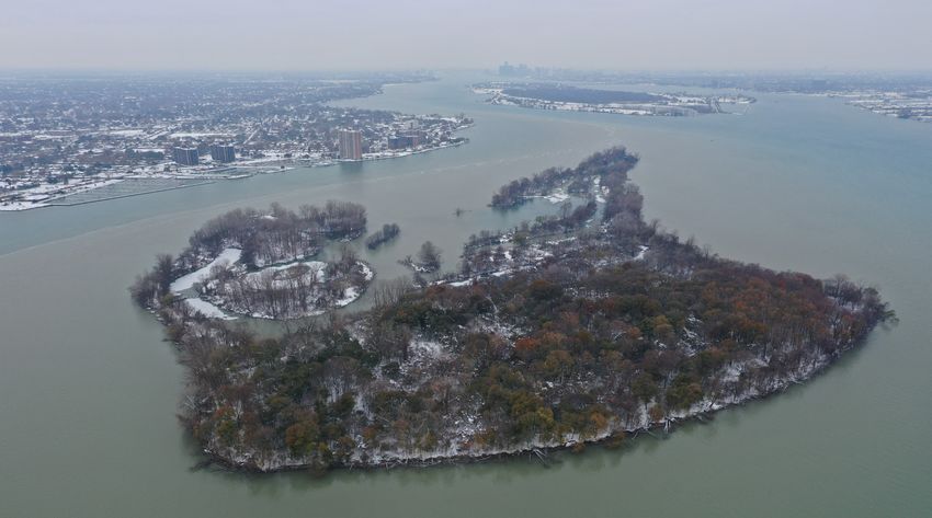
Chapter                                                                                   Chapter

                                             2                                                                                         3
                                            Belle River                                                                                 Sarnia Harbour

Lake St. Clair                                                                          St. Clair River
General .  .  .  .  .  .  .  .  .  .  .  .  .  .  .  .  .  .  .  .  .  .  .  .  . 2-1   General .  .  .  .  .  .  .  .  .  .  .  .  .  .  .  .  .  .  .  .  .  .  .  .  . 3-1
Main ship channel .  .  .  .  .  .  .  .  .  .  .  .  .  .  .  .  .  .  .  .  2-2           South Channel .  .  .  .  .  .  .  .  .  .  .  .  .  .  .  .  .  .  . 3-2
South east coast of Lake St. Clair.  .  .  .  .  .  .  .  .  .  .  . 2-2                Chenail Ecarté and Sydenham River  .  .  .  .  .  .  .  .  .  .  3-4
    Pike Creek  .  .  .  .  .  .  .  .  .  .  .  .  .  .  .  .  .  .  .  .  . 2-2           Sydenham River .  .  .  .  .  .  .  .  .  .  .  .  .  .  .  .  .  . 3-5
    Puce River  .  .  .  .  .  .  .  .  .  .  .  .  .  .  .  .  .  .  .  .  . 2-3           Wallaceburg  .  .  .  .  .  .  .  .  .  .  .  .  .  .  .  .  .  .  .  . 3-5
    Belle River  .  .  .  .  .  .  .  .  .  .  .  .  .  .  .  .  .  .  .  .  . 2-3      Continuation of St. Clair River .  .  .  .  .  .  .  .  .  .  .  .  .  .  3-6
    Ruscom River .  .  .  .  .  .  .  .  .  .  .  .  .  .  .  .  .  .  .  .  2-4        Sarnia  .  .  .  .  .  .  .  .  .  .  .  .  .  .  .  .  .  .  .  .  .  .  .  .  .  .  3-9
    Stoney Point  .  .  .  .  .  .  .  .  .  .  .  .  .  .  .  .  .  .  .  . 2-4
    Thames River .  .  .  .  .  .  .  .  .  .  .  .  .  .  .  .  .  .  .  .  2-4
    Chatham  .  .  .  .  .  .  .  .  .  .  .  .  .  .  .  .  .  .  .  .  .  . 2-6
                                                                                        Appendices
NE coast of Lake St. Clair .  .  .  .  .  .  .  .  .  .  .  .  .  .  .  .  2-6          Sail Plan .  .  .  .  .  .  .  .  .  .  .  .  .  .  .  .  .  .  .  .  .  .  .  .  . A-1
    Mitchell’s Bay .  .  .  .  .  .  .  .  .  .  .  .  .  .  .  .  .  .  .  .  2-6      Distance Table .  .  .  .  .  .  .  .  .  .  .  .  .  .  .  .  .  .  .  .  .  . A-3
U.S. shores of Lake St. Clair  .  .  .  .  .  .  .  .  .  .  .  .  .  . 2-7
                                                                                        Index
                                                                                        Index .  .  .  .  .  .  .  .  .  .  .  .  .  .  .  .  .  .  .  .  .  .  .  .  .  .  .  l-1

                                                                                                                                                                                III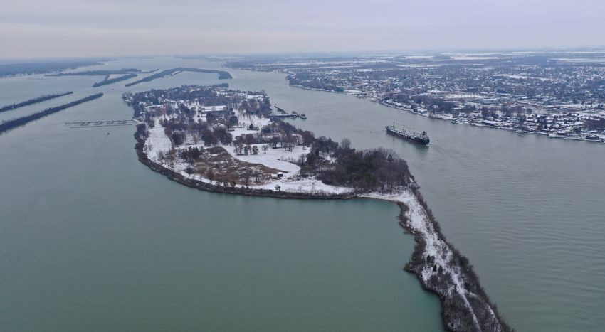
Preface
The Second Edition of Sailing Directions, CEN 304 — Detroit River, Lake St. Clair, St. Clair River 2020, has been
compiled from Canadian Government and other information sources. All hydrographic terms used in this booklet are
in accordance with the meanings given in the Hydrographic Dictionary (Special Publication No. 32), published by the
International H
ydrographic Organization.
General information for the Great Lakes is grouped within one booklet, Sailing Directions, CEN 300 — General
Information, Great Lakes, 1996. It contains navigational information and a brief description of the main port facilities as
well as geographic, oceanographic and atmospheric characteristics.
The detailed description of the geographical areas is given in a series of booklets. Their limits are printed on the
back cover of the booklets. The appropriate descriptive booklet(s) should be consulted in conjunction with the
CEN 300 — General Information booklet.
The photographs are by the Canadian Hydrographic Service, Department of Fisheries and Oceans, Burlington, Ontario.
Explanatory Notes
Canadian Sailing Directions expand charted details and Units and terminology
provide important information of interest to navigation used in this booklet
which may not necessarily be found on charts or in other
marine publications. They are intended to be read in Latitude and longitude given in brackets are approximate
conjunction with the charts quoted in the text. and are intended to facilitate reference to the chart quoted.
Bearings and directions refer to True North (geographic)
Remarks and are given in degrees from 000° clockwise to 359°. The
bearings of conspicuous objects, ranges and light sectors
Buoys are described in detail only where they have special are given from seaward. Courses always refer to the
navigational significance, or where the scale of the chart is course to be made good.
too small to clearly show all the details.
Tidal streams and currents are described by the
Chart references, in italics, refer to the largest scale direction towards which they flow. The ebb stream is
Canadian chart. Occasionally a smaller scale chart caused by a falling tide and the flood stream is caused by
may be quoted where its use is more a ppropriate. a rising tide. Winds are described by the direction from
which they blow.
Tidal information relating to the vertical movements of
the water is not given and the Canadian Tide and Current Distances, unless otherwise stated, are expressed in
Tables should be consulted. However, abnormal changes nautical miles. For practical purposes, a nautical mile is
in water level are noted. considered to be the length of one minute of arc, measured
along the meridian, in the latitude of the position. The
Names have been obtained from the Geonames database
international nautical mile, which has now been adopted
administered by Natural Resources Canada (NRCan).
by most maritime nations, is equal to 1852 m (6076 ft).
Where an obsolete name still appears on the chart or is
of local usage, it is given in brackets following the Speeds are expressed in knots, which means 1 nautical
official name. mile per hour.
Wreck information is included where drying or Depths, unless otherwise stated, are referred to chart
submerged wrecks are relatively permanent features datum. As depths are liable to change, particularly those
and are of navigation or anchoring significance. in dredged channels and alongside wharves, it is strongly
recommended these be c onfirmed by the appropriate
local authority.
IV
Elevations and vertical clearances are given above Deadweight tonnage and masses are expressed in metric
Higher High Water, Large Tide. In non-tidal waters they tonnes of 1000 kilograms (2204.6 pounds). The kilogram
are referred to chart datum. is used to describe relatively small masses.
Heights of objects, distinct from elevations, refer to the Public wharf is a wharf that is available for public use,
heights of the structures above the ground. though certain fees may be charged by local authorities. It
may be shown as “Government Wharf” or “Govt Whf” on
The List of Lights, Buoys and Fog Signals number is older charts.
shown in brackets after the navigational aid (light, leading
lights, buoy). The expression “seasonal” indicates that it is Conspicuous objects, natural or artificial, are those which
operational for a certain period during the year; mariners stand out clearly from the background and are easily
should consult the List of Lights, Buoys and Fog Signals identifiable from a few miles o ffshore in normal visibility.
to determine the period of operation. The expression
“private” means that the navigational aid is privately The expression “small craft” refers to pleasure craft and
maintained; it will not necessarily be mentioned in the small vessels with shallow draught.
List of Lights, Buoys and Fog Signals and its characteristics
may change without issuance of a Notice to Shipping. Diagrams are large scale cartographic representations of
harbours, wharves, anchorages, or marinas.
Time, unless otherwise stated, is expressed in local
standard or daylight time. For the waters described in this Pictographs are symbols shown at the beginning of the
booklet, local time is Eastern Standard Time (EST) . paragraphs to allow quick reference to information or to
emphasize details. The Pictograph Legend is shown on
the inside front and back covers of this booklet.
References to other publications
Canadian Coast Guard
• List of Lights, Bouys and Fog Signals
• Radio Aids to Marine Navigation (Atlantic, St. Lawrence, Great Lakes, Lake Winnipeg and Eastern Arctic)
• Ice Navigation in Canadian Waters
• Annual Edition of Notices to Mariners
• The Canadian Aids to Navigation System
• Merchant Ship Search and Rescue Manual (CANMERSAR)
• The International Code of Signals
Environment Canada
• Great Lakes Marine Weather Guide
• Great Lakes Climatological Atlas
Canadian Hydrographic Service
• Canadian Tidal Manual
• Chart No. 1 — Symbols, Abbreviations and Terms
• Tides in Canadian Waters
• Notes on the Use of Loran-C Charts
• Canadian Tide and Current Tables
• Catalogue of Nautical Charts and Publications (Great Lakes)
St. Lawrence Seaway Authority
• The Seaway Handbook
V
Abbreviations
Units Directions Various
°C degree Celsius N north A.P.A. Atlantic Pilotage Authority
cm centimetre NNE north northeast CCG Canadian Coast Guard
fm fathom NE northeast CHS Canadian Hydrographic Service
ft foot ENE east northeast DFO Department of Fisheries and Oceans, Canada
h hour E east DWT deadweight tonnage
ha hectare ESE east southeast ETA estimated time of arrival
HP horsepower SE southeast ETD estimated time of departure
kHz kilohertz SSE south southeast HF high frequency
km kilometre S south HW high water
kn knot SSW south southwest LW low water
kPa kilopascal SW southwest MCTS Marine Communications and Traffic Services
m metre WSW west southwest NAD North American Datum
M million, mega W west No. number
mb millibar WNW west northwest SAR Search and Rescue
min minute NW northwest U.S.A. United States of America
MHz megahertz NNW north northwest VHF very high frequency
mm millimetre VTS Vessel Traffic Services
NM nautical mile
t metric tonne
° degree (plane angle)
' minute (plane angle)
Corrections
All corrections published through Notices to Mariners up to and including the Monthly Edition shown in the table below
have been incorporated in this edition. This booklet should be kept up-to-date by applying corrections published in Section 4
of the monthly Canadian Notices to Mariners at: www.notmar.gc.ca.
This booklet should not be used without reference to the pertinent
corrections in Notices to Mariners.
Record of corrections to this Sailing Directions booklet
from monthly Notices to Mariners.
N/M No. Inserted by N/M No. Inserted by N/M No. Inserted by N/M No. Inserted by
VI
Chapter 1

                                                                                     Detroit River
                                                             General
                                                Belle Isle

                      Detroit                                Charts 2123, 14848, 14853
                                              Windsor        1         Detroit River is 28 miles (51 km) long from
                                                             Detroit River light at its mouth in Lake Erie to its head at
                                                             Windmill Point, at the SW corner of Lake St. Clair. It is
                                                             navigated by the largest vessels on the Great Lakes.
                           Detroit River

                                                             2         The southern part, or lower river, is broad and has
                                                             many islands and shallow areas. The river banks are lower
                                                             than in the upper river, and the bottom consists mainly of
                                                             sediment and boulders. A 5.5-mile section (8.8-km) north
                                                             of the south end of Bois Blanc Island is, however, mainly
                                                             bedrock and boulders. Dredged channels allow the passage
                                                             of large ships.
Detroit River light
                                                             3         For the northern 12 miles (22.2 km), upstream of
                                                             Fighting Island, the river is a single deep channel except at
                        CAN

                                                             its head where it is divided by Peche Island and Belle Isle.
                          U.S

                                           Lake Erie         The water is mainly deep, the bottom is of sediment, and
                            ADA
                              .A.

                                                             the river banks are steep.
                                                             4         Depths and vertical clearances under cables and
                                                             bridges on Detroit River refer to the sloping surface of the
                                                             river corresponding to a Lake St. Clair elevation of 572.3 ft
                                                             (174.4 m) above IGLD 1985 and a Lake Erie elevation
                                                             of 569.2 ft (173.5 m) above IGLD 1985. More informa-
                                                             tion on chart datums is given in Sailing Directions booklet
                                                             CEN 300 — General Information, Great Lakes.
                                                             5         Real-time water level information for Detroit Riv-
                                                             er at Amherstburg is available from the Canadian Hydro-
                                                             graphic Service Automated Water Level Gauge, telephone
                                                             number 519‑736‑4357. (More information on water levels
                                                             is given in Sailing Directions booklet CEN 300 — General
                                                             Information, Great Lakes.)
                                                             6         Charted depths in St. Lawrence Seaway channels
                                                             are reported to be maintained by periodic dredging. Latest
                                                             information on depths should be obtained from local au-
                                                             thorities. Controlling depths in the channels are announced
                                                             by United States Coast Guard Local Notice to Mariners.
                                                                     7        Caution. — Seasonal fluctuations of water
                                                                     level give a normal range of about 2 ft (0.6 m) in
                                                             monthly mean levels in the river. Strong east or west winds,
                                                             however, can raise or lower water levels in the west end of
                                                             Lake Erie and Detroit River by as much as 6 ft (1.8 m) in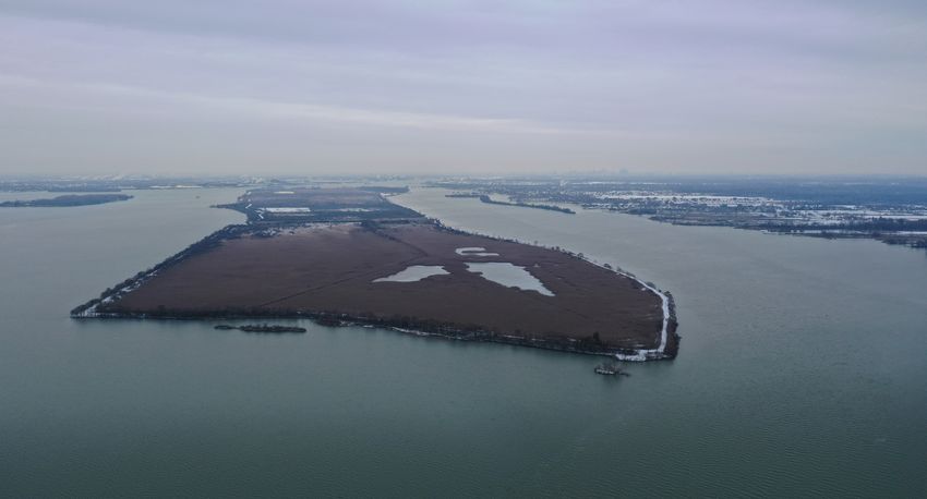
1-2             CEN 304
                    Detroit River — Lake St. Clair — St. Clair River

eight hours. Atmospheric pressure changes may also cause                  Navigation Safety Regulations, quoted in Sailing Directions
fluctuations of 1 foot (0.3 m) or more.                                   booklet CEN 300 — General Information, Great Lakes.
8         On the 5th and 20th days of each month during the               12        The speed limit for the harbour at Windsor is set by
navigation season, the U.S. Corps of Engineers, Detroit                   the Windsor Port Authority at 8 knots (15 km/h), except for the
District, publishes a bulletin of the predicted range of water            channel south of Peche Island. The speed limit in this channel,
levels. When the water level in the west end of Lake Erie                 between buoys DP2 and DP5, is 5 knots (9.4 km/h). The wat-
falls 1 inch (2.54 cm) or more below the predicted level,                 ers inside the limits of the formerly named Peche Island Prov-
the United States Coast Guard, Sector Detroit, broadcasts                 incial Park are subject to a speed limit of 3.2 knots (6 km/h).
low water warnings on Channel 12 (156.60 MHz) on the                              13        There are Marine Communications and
odd hour plus 55 minutes.                                                         Traffic Services (MCTS) calling-in points in Detroit
                                                                          River and its approaches. For details consult the St. Clair
            [from U.S. Coast Pilot 6, Chapter 7, partial]                 and Detroit River Navigation Safety Regulations and the
                                                                          Radio Aids to Marine Navigation (Atlantic, St. Lawrence,
9          The following currents are based on the aver-                  Great Lakes, Lake Winnipeg, Arctic and Pacific).
ages of water flow through the entire cross section of the                14        Canadian Government regulations are available at:
river, that is, from bank to bank and from the surface to the             http://laws.justice.gc.ca/.
bottom during normal water flow conditions. Normal water
                                                                          15        Most of the marinas on the Canadian side of De-
flow conditions are encountered when there is no wind,
                                                                          troit River are Customs telephone reporting site/marine for
Lake St Clair is at a stage of 573.9 feet [174.9 m], and the
                                                                          pleasure craft: http://www.cbsa-asfc.gc.ca/do-rb/services/
lower Detroit River [Lake Erie] stage is 571.0 feet [174.0
                                                                          trsm-sdtm-eng.html.
m] above mean water level at Rimouski, QC, on Inter-
national Great Lakes Datum 1985 [IGLD 1985], that is 1.6
                                                                                   [from U.S. Coast Pilot 6, Chapter 7, partial]
feet [0.5 meter] and 1.8 feet [0.5 m] above their respective
Low Water Datums. The current encountered at midstream
                                                                          16        ENCs US4MI11M, US5MI12M, US5MI30M,
 Current Rates on Detroit River                                           US5MI28M, US5MI29M, US5MI22M, Charts 14830,
                           High water     Medium water   Low water flow   14848, 14852, 14854.–Detroit River Light (42°00'03"N.,
                           flow (knots)   flow (knots)   (knots)          83°08'28"W.), 55 feet [17 m] above the water, is shown
 Livingstone Channel            0.7           0.6              0.6        from a white conical tower with black top, on a hexagonal
 Upper Entrance light                                                     pier in the entrance to the Detroit River at the junction of
 Fighting Island Channel        1.3           1.3              1.2        East and West Outer Channels; a sound signal and racon
 North light                                                              are at the light.
 1.5 miles below                1.4           1.3              1.2        17        Channels.–East Outer Channel and West Outer
 Ambassador Bridge                                                        Channel, dredged and well marked, lead northward
 Lower end of Belle Isle        1.2           1.1              1.0        through the shallows at the upper end of Lake Erie to the
                                                                          mouth of the Detroit River. Immediately north of Detroit
is usually about 1.5 times the average velocity. Greater                  River Light, the channels merge to form lower Livingstone
velocities may be expected when the difference between the                Channel. A Federal project provides for a depth of 28.5 feet
                                                                          [8.6 m] in East Outer Channel and 22 feet [6.7 m] in West
lake levels is greater, or when lake stages are higher.
                                                                          Outer Channel. (See Notice to Mariners and latest edition
          10      Detroit River is a designated pilotage area.
                                                                          of the above charts for controlling depths.)
          There are pilot exchange points south of Ambassa-
                                                                          18        East Outer Channel is a two-way passage. West
dor Bridge (42°19'N, 83°04'W) and in Lake Huron off the
                                                                          Outer Channel may be used by downbound vessels whose
head of St. Clair River. For more information on pilotage,
                                                                          drafts permit. (See 33 CFR 162.130, through 162.140,
consult Sailing Directions booklet CEN 300 — General                      chapter 2 [of U.S. Coast Pilot 6], for regulations.) East
Information, Great Lakes, the Annual Edition of Notices                   Outer Channel Light 1E is equipped with a racon and a
to Mariners and Radio Aids to Marine Navigation (Atlan-                   seasonal sound signal.
tic, St. Lawrence, Great Lakes, Lake Winnipeg, Arctic and                 19        ... A Federal project provides for a depth of 29.0
Pacific).                                                                 feet [8.8 m] in lower Livingstone Channel.
11          There are speed limits on Detroit River for all               20        An unmarked temporary dumping ground is in the
vessels with an overall length of 65.6 ft (20 m) or more.                 approach to the Detroit River between East and West Outer
The speed limits are listed in the St. Clair and Detroit River            Channels.
CHAPTER 1
Detroit River
1-3
21 The lower part of the Detroit River west of Living- Lower Livingstone Channel
stone Channel is open and generally shallow with several
small islands. Natural channels with depths of about 13 feet 25 Lower Livingstone Channel (42°01'N,
[4 m] and less, marked by buoys, provide access for small 83°08'W) is for two-way traffic from Detroit River light
craft. for the 2.3 miles (4.2 km) to the southern junction of
22 West of the lower end of the revetments in Living- Amherstburg Channel and upper Livingstone Channel.
stone Channel, a small-craft channel marked by buoys 26 Detroit River Pier light D30 (640) is shown
at an elevation of 33.4 ft (10.2 m) from a white cylin-
leads from the open part of the lower Detroit River between
drical tower with a red band at the top and marked D30.
Sugar Island, MI and Meso Island, MI along the Grosse
27 Bar Point Pier light D33 (642), at the southern
Ile shore and thence west of Stony Island, MI. In the nar- junction of Amherstburg Channel and Livingstone Chan-
row part of this channel between Stony Island and Grosse nel, is shown at an elevation of 45.9 ft (14 m) from a white
Ile, a line of submerged bridge abutments cross the channel cylindrical tower marked D33.
with a least depth of ½ foot [0.1 m]. Submerged cables fol-
low the same line south and north of the abutments.
23 A natural channel marked by buoys leads from Amherstburg Channel
open water in the lower part of the Detroit River along
the east side of Celeron Island and connects with Trenton Charts 14853, 14848
Channel at Gibraltar. The least depth in this channel is
28 Bois Blanc Island (42°06'N, 83°07'W), in Can-
about 7 feet [2.1 m]. adian waters 5.5 miles (10.2 km) north of Detroit River light,
24 Sugar Island Cut, about 400 feet [121.9 m] wide, is known locally as Bob-Lo Island. At the south end of
is an opening between the east side of Sugar Island and a the island there is Bois Blanc Island Lighthouse and
compensating revetment that extends west from the west Blockhouse National Historic Site of Canada. Am-
revetted wall of Livingstone Channel. herstburg is on the mainland east of Bois Blanc Island.
LIVINGSTONE CHANNEL AND AMHERSTBURG CHANNEL FROM SOUTH (2019)1-4 CEN 304
Detroit River — Lake St. Clair — St. Clair River
29 Amherstburg Channel, for upbound traffic, orange triangular daymark with a black vertical stripe and
passes east of Bois Blanc Island; it has three reaches. Hack- marked D65. The rear light (664) is shown at an elevation
ett Reach extends 3.2 miles (5.9 km) NNE from the junction of 45 ft (13.7 m) from a white skeleton tower with a fluores-
with Livingstone Channel to the south end of Bois Blanc cent-orange inverted triangular daymark with a black vertical
Island; Amherstburg Reach extends 1 mile (1.8 km) to the stripe. The lights are visible on the line of the range.
north end of Bois Blanc Island; Limekiln Crossing Reach ex- 37 Limekiln Crossing leading lights, in line bear-
tends 1 mile (1.8 km) to the junction with Ballards ing 003°, are 1.5 miles (2.8 km) north of the Hackett Reach
Reef Channel. range lights. The front light (672) is shown at an eleva-
30 Hackett Reach, Amherstburg Reach and Limekiln tion of 25 ft (7.6 m) from a white skeleton tower with a
Crossing Reach are divided along their length into two fluorescent-orange triangular daymark with a black vertical
halves; the shallow-draught channel is on the eastern side stripe. The rear light (673) is shown at an elevation of 40 ft
of these reaches and the deeper channel is on the west. The (12.2 m) from a white cylindrical tower with a fluorescent-
deep-draught channel and the shallow-draught channel are orange triangular daymark with a black vertical stripe. The
each 300 ft (91.4 m) wide. The channels are buoyed, and lights are visible on the line of the range.
range lights indicate the centreline of the deep channel on 38 Light D69 (669), 0.3 mile (0.6 km) north of the
each reach or course. rear Amherstburg range light, is shown at an elevation of
31 Caution. — Due to the current, extra care 27.5 ft (8.4 m) from a white cylindrical tower with a green
is necessary when turning from Hackett Reach into upper part and marked D69. Light D71 (670), 0.16 mile
Amherstburg Reach. (0.3 km) farther north, is shown at an elevation of 33 ft
32 Bar Point leading lights, in line (10.1 m) from a white cylindrical tower, 24 ft (7.3 m) high,
bearing 013½°, are on the south part of the dyke with a green upper part and marked D71.
extending south from Bois Blanc Island. The front light 39 A self-propelled barge is reported to operate a
D49 (648) is shown at an elevation of 31 ft (9.4 m) from ferry service to Bois Blanc Island from a wharf on the
a white cylindrical tower with a green upper part and a mainland near the Hackett Reach rear light. This ferry is
fluorescent-orange triangular daymark with a black vertical reported to operate on demand.
stripe and marked D49. The rear light (649) is shown at 40 Several submerged cables cross Amherstburg
an elevation of 60 ft (18.3 m) from a white skeleton tower Channel.
with a fluorescent-orange inverted triangular daymark with a
black vertical stripe. The lights are visible on the line of the
range. Livingstone Channel
33 Light D53 (653), 0.6 mile (1.1 km) NNE of the
Bar Point rear range, is shown at an elevation of 31 ft 41 The northern part of Livingstone Channel, from
(9.4 m) from a white cylindrical tower, with a green upper Bar Point Pier light D33 to Ballards Reef Channel
part and marked D53. (42°08'N, 83°07'W) (described below), is for downbound
34 Hackett Reach leading lights, in line bearing 015°, traffic; it passes west of Bois Blanc Island. Much of the chan-
are in the town of Amherstburg. The front light (656) is nel runs between rubble dykes. The sides of the channel are
shown at an elevation of 45 ft (13.7 m) from a white cylin- marked by lights and buoys.
drical tower with a fluorescent-orange triangular daymark 42 Hole-in-the-Wall, a gap in the Livingstone Chan-
with a black vertical stripe. The rear light (657) is shown at nel dykes NW of Bois Blanc Island, allows small craft to
an elevation of 81 ft (24.8 m) from a white skeleton tower cross the main channel. A strong SW current flows through
with a fluorescent-orange inverted triangular daymark with Hole-in-the-Wall.
a black vertical stripe. The lights are visible on the line of 43 Livingstone Channel Upper Entrance
the range. light (677), on a white square crib at the north end
35 Light D61 (660), on the east side of Bois Blanc of the Livingstone Channel near the intersection of Ballards
Island, is shown at an elevation of 33 ft (10.1 m) from Reef Channel and Livingstone Channel, is shown at an
a white cylindrical tower, 24 ft (7.3 m) high, with a green elevation of 42.3 ft (12.9 m) from a white cylindrical
upper part and marked D61. tower 20 ft (6.1 m) high.
36 Amherstburg leading lights are in line bear- 44 Livingstone Channel lights. — On the west side of
ing 356°. The front light D65 (663), on the south end of Livingstone Channel, Lights 25 (US 7240), 23 (US 7250),
the dyke 0.4 mile (0.7 km) north of Bois Blanc Island, 21 (US 7260) and 19 (US 7275) are shown from black
is shown at an elevation of 30 ft (9.2 m) from a white masts with a green square daymark. Lights DL17 (696),
cylindrical tower with a green upper part and a fluorescent- DL15(694) and DL13 (692) are shown from white cylin-CHAPTER 1
Detroit River
1-5
BOIS BLANC ISLAND AND AMHERSTBURG (2019)
drical towers with a green upper part and are visible from all Amherstburg
points of approach on channel side . Lights 23 and 19 show 48 The town of Amherstburg, with a population
a higher intensity up and down the channel. of 21 936 (2016), is a tourist resort with much historic
45 Marking the east side of the channel, Lights appeal, having been a major battleground in the War
26 (US 7245) and 24 (US 7255) are shown from red masts of 1812 and also the northern end of the Underground
with a red triangular daymark; Light 24 shows a higher Railroad for escaping slaves. There are also chemical,
intensity up and down channel. Lights DL22 (701), distillation and manufacturing plants in the area.
49 A Canadian Coast Guard Base lies
DL20 (699), DL18 (697), DL16 (695) and DL14 (693)
between the Hackett Reach leading lights. The
are shown from a white cylindrical tower, 24 ft (7.3 m) south wharf has a buoy maintenance and storage build-
high, with a red upper part. ing; the wharf is 250 ft (76.2 m) long and has a depth of
46 The limits of Amherstburg Harbour are 21 ft (6.4 m). A protected basin formed by the northern
defined as all of the waters of the Detroit River and of Lake part of the south wharf has a depth of 3 ft (0.9 m). The north
Erie on the Canadian side of the International Boundary wharf, 290 ft (88.4 m) long, has workshops and office build-
south of the southerly limit of Windsor Harbour and ings. In an emergency, temporary berthing at the Canadian
Coast Guard Base may be requested through the Canadian
west of the meridian of longitude 83°05'00"W. The
Coast Guard. There is a launching ramp at the base.
southerly limit of Windsor Harbour is a straight line
50 Amherstburg is a Customs telephone reporting
drawn from Fighting Island North light at the International station/marine for pleasure craft.
Boundary (42°14'N, 83°08'W) in a 046½ ° direction to the 51 The former Allied Chemical wharf, at the
high water mark on the shore. upper end of Amherstburg, is a series of dolphins
47 Amherstburg Harbour is a Public Harbour connected by catwalks. The wharf is 300 ft (91.4 m)
administered by Town of Amherstburg. For harbour long with a depth of 21 ft (6.4 m).
regulations see Sailing Directions booklet CEN 300 - 52 A Canadian Coast Guard Rescue Cut-
ter is based at Amherstburg from the beginning of
General Information, Great Lakes.1-6 CEN 304
Detroit River — Lake St. Clair — St. Clair River
AMHERSTBURG COAST GUARD BASE (2019)
April to mid-December each year, though these dates are [from U.S. Coast Pilot 6, Chapter 7, partial]
subject to change (see information on Search and Rescue
in S ailing Directions booklet CEN 300 — General Infor- 58 Grosse Ile, MI, about 8 statute miles [7 nm] long
and 1.5 statute miles [1.3 nm] wide, is the largest island
mation, Great Lakes).
in the Detroit River. It extends along the west side of the
53 Caution. — Extra care is neces-
dredged river channels from about the midpoint of upper
sary when anchoring in Amherstburg
Livingstone Channel north to about the midpoint of Fight-
Channel between its upper end and the south end of Bois
ing Island Channel opposite the city of Wyandotte, MI. Tren-
Blanc Island; the current may cause an anchor to drag ton Channel separates the west side of the island from the
and overturn rocks which then become obstructions. mainland. The north end of the island, Point Hennepin,
54 A submerged water intake north of the front MI, is a waste disposal site; the rest of the island consists
structure of the Fort Malden range lights extends 300 ft mostly of residential communities and private facili-
(91.4 m) into the river. ties.
55 Caution. — Small craft operators have re- 59 Thorofare Canal, a large shallow drainage ditch
ported striking two submerged obstructions between about 3.5 [3] miles long, crosses the body of Grosse
the west side of Bois Blanc Island and the Livingstone Chan- Ile in a northeast-southwest direction. Several highway
bridges and overhead cables cross this ditch. Passage should
nel dyke.
not be attempted without local knowledge.
56 There are several small wharves and mar-
60 A slow-no wake speed is enforced within 1,000 feet
inas in the area of Amherstburg Channel.
[305 m] of shore of Grosse Ile, except in Trenton Channel
57 Amherstburg Yacht Club, 1 mile (1.8 km) farther
and in the channel between the northeast side of the island
north, has depths of 1 to 2 ft (0.3 to 0.6 m) and offers dockage, and Mamajuda Island Shoal. A slow-no wake speed is en-
ramp, pump-out, drinking water, some groceries, restrooms, forced in Thorofare Canal and in the canals between Grosse
showers, Wi-Fi, ice and gasoline and diesel fuel. Ile and the small islands off its south end.CHAPTER 1
Detroit River
1-7
FIGHTING ISLAND FROM SOUTH (2019)
Ballards Reef Channel 66 Fort Malden leading lights, in line bear-
ing 162½°, are on the east shore opposite the Amherst-
61 Ballards Reef Channel (42°09'N, 83°07'W) burg leading lights. This range marks the centre-line
is 2 miles (3.7 km) long from its southern end at the of Ballards Reef Channel. The front light (667) is shown
junction with Limekiln Crossing Reach of the Amherstburg from a white skeleton tower, 22 ft (6.7 m) high, with a
fluorescent-orange triangular daymark with a black verti-
Channel to its northern end at the junction with Fight-
cal stripe. The rear light (668) is shown from a white
ing Island Channel. The channel is well marked by buoys;
skeleton tower, 52.2 ft (15.9 m) high, with a fluorescent-
leading lights indicate the centre-line.
orange inverted triangular daymark with a black vertical
62 Caution. — Due to strong currents
stripe. The lights are visible on the line of the range.
at the junction of Livingstone Channel and
67 Light D77 (678), on a pier on the west side of
Ballards Reef Channel, mariners are cautioned to favour the
Ballards Reef Channel, is shown at an elevation of 37
west side of the channel.
ft (11.3 m) from a white square structure with a green
63 Three submerged cables cross the main shipping vertical stripe on each corner and marked D77.
channels near the junction of Ballards Reef Channel and 68 Canard River flows into Detroit River east of
Livingstone Channel. Ballards Reef Channel. The channel leading to the river
64 Caution. — The base of an old light struc- entrance is marked by private buoys.
ture lies 26 ft (7.9 m) north of Livingstone Channel 69 Anderdon Harbour Light Tavern, on the east shore
Upper Entrance light. This obstruction is submerged by 0.1 mile (0.2 km) north of Limekiln Crossing rear leading
about 2 ft (0.6 m) and is marked by an uncharted red spar light, has depths of 1 to 5 ft (0.3 to 1.5 m) and offers dock-
buoy. age to their customers (overnight berthing by prior arrange-
65 An auxiliary channel passing east of Fighting ment).
Island joins Ballards Reef Channel and is marked by spar 70 Fighting Island (42°13'N, 83°07'W), in Can-
buoys. All vessels whose draughts permit should use this adian waters east of the main shipping channel, is a marsh or
auxiliary channel in order to relieve congestion in the main waste bed fill and gravel island 3 miles (5.6 km) long
shipping channel. and 0.4 mile (0.7 km) wide with an elevation of 13 ft1-8 CEN 304
Detroit River — Lake St. Clair — St. Clair River
(4 m). Many swans and bald eagles are reported living in 82 Holiday Harbour Marina, home of the Sun
this area. Turkey Island, low and marshy with a few trees, Parlour Boat Club, 0.1 mile (0.2 km) farther north, has
and Grassy Island lie between Fighting Island and the depths of 4 to 5 ft (1.2 to 1.5 m) and offers dockage with
Canadian mainland. power and water, ramp, engine repairs, 15-tonne hoist,
71 The community of La Salle (42°14'N, fishing boat rentals, picnic area, showers, ice, boat hardware,
83°06'W), population 30 180 (2016), lies east of the a swimming pool and recreation hall, used boat sales, and
north end of Fighting Island. a taxi shuttle to Windsor Casino. There is a privately
72 Several submerged cables cross the channel maintained light on each side of the entrance. It was for
between La Salle and Fighting Island. sale in 2017.
73 There are many marinas at La Salle and 83 Mona’s Place, on the east shore 0.2 mile (0.4 km)
along the mainland side of the channel east of Fighting north of Grassy Island, has depths of 3 to 5 ft (0.9 to 1.5 m)
Island. La Salle is a Customs telephone reporting site/ and offers water, pump out, ramp, snack bar, ice, gasoline
marine for pleasure craft. and diesel fuel. Mona’s Place is a Customs telephone
74 Acali Place Marina, 2 miles (3.7 km) south of reporting site/marine for pleasure craft.
La Salle, has depths of 2 ft (0.6 m) in the approaches and 84 Westport Marina, at La Salle, has depths of 5
3 ft (0.9 m) at the wharves and offers dockage with power to 6 ft (1.5 to 1.8 m) and offers dockage with power and
and water, pump out, ramp, repairs, 20-tonne hoist, pic- water, pump out, ramp, repairs, 35-tonne hoist, boat hard-
nic and camping area,showers and ice. Under new owner- ware, marine electronics repair, showers and ice. It was for
ship in 2018.
sale in 2018.
75 Boat Doctor’s River Run Marina, 0.15 mile
85 Park Haven Marina, 0.15 mile (0.27 km) farther
(0.27 km) north of Acali Place Marina, has depths of 2 ft
north, has depths of 1 to 2 ft (0.3 to 0.6 m) and offers
(0.6 m) in the approaches and up to 4 ft (1.2 m) at the
dockage with power and water, pump out, repairs, 5-tonne
wharves and offers dockage with power and water, ramp,
hoist, new and used boat parts, picnic area, showers and ice.
32-tonne hoist, picnic area, camping, showers, ice and
inside storage. The entrance channel to this marina is
privately buoyed.
76 Mueller’s Marina, next north, has depths of 3 ft
Fighting Island Channel
(0.9 m) in the approaches and 5 ft (1.5 m) at the wharves
and offers dockage with power and water, ramp and picnic
[from U.S. Coast Pilot 6, Chapter 7, partial]
area.
77 Riverfront Harbour Marina, a private facility
86 Fighting Island Channel extends from the upper
just north of Mueller’s Marina, has depths of 1 ft (0.3 m).
end of Ballards Reef Channel, about 2 [1.7] miles below
78 St. Clair Marine, 1.6 miles (3 km) south of
La Salle, has depths of l ft (0.3 m) in the approaches and 1 the head of Grosse Ile, along the west side of Fighting
to 2 ft (0.3 to 0.6 m) at the wharves and offers dockage Island to the natural deep water north of Fighting Island.
with power and water, repairs, 30-tonne hoist, mast stepper, A Federal project provides for a depth of 28.5 feet [8.7 m]
winter storage and boat hardware. in Fighting Island Channel. (See Notice to Mariners and
79 La Salle Mariner’s Yacht Club, a private club latest edition of charts for controlling depths.)
0.1 mile (0.2 km) north of St. Clair Marine, has depths of 5 87 Anchorage.–A deep-draft anchorage, marked on
to 13 ft (1.5 to 4 m). the west side by buoys, is on the west side of the south end
80 Island View Marine Store & Marina, on the east of Fighting Island Channel. The anchorage is used when
shore opposite Grassy Island, has depths of 2 ft (0.6 m) conditions are unfavorable for proceeding through the con-
and offers dockage with power and water, pump out, ramp, fined deep channels leading south into Lake Erie. Vessels
repairs and salvage, 15-tonne hoist, boat sales and service, using this anchorage should be careful to avoid Mamajuda
boat hardware, picnic area, showers, ice, some groceries, Island Shoal, a long shoal extending from the north end
bait, tackle and snack bar. of Grosse Isle (Point H ennepin) into the north side of the
81 Beattie’s Sunset Marina (formerly Pilot House anchorage.
Marina), next north, has depths of 2 to 3 ft (0.6 to 0.9 m) 88 A buoyed natural channel leads north from the
and offers dockage with power and water, ramp, repairs, northwest part of the anchorage between the upper end
25-tonne hoist, picnic area, swimming pool, showers, of Grosse Ile and Mamajuda Island Shoal and joins
laundromat, ice, and snack bar and restaurant with licensed with Trenton Channel at Wyandotte, MI. The controlling
dining room. It was for sale in 2017. depth in the channel is about 21 feet [6.4 m].CHAPTER 1
Detroit River
1-9
89 Fighting Island North light (684.3), on a chapter 2 [of U.S. Coast Pilot 6], for drawbridge regula-
pier on the east side of the north entrance to Fighting tions.)
Island Channel, is shown at an elevation of 34.8 ft (10.6 m) 96 Wyandotte, MI, fronts Trenton Channel for
from a white cylindrical tower, with a red upper part. about 3 [2.6] miles opposite Point Hennepin. The city is an
90 A submerged water intake extending from the important industrial center, and numerous stacks in the city
United States’ shore passes under Trenton Channel, are prominent from the river.
Grassy Island and Fighting Island Channel to an intake crib 97 A slow-no wake speed is enforced within 1,000 feet
200 ft (61 m) east of Fighting Island Channel. The intake [305 m] of shore in the waters of the Detroit River adjacent to
crib is marked at each end by a privately maintained light. the city of Wyandotte.
Several other submerged pipelines cross Fighting Island 98 Towage.–Tugs for Wyandotte are available from
Channel and Trenton Channel. Detroit. (See Towage under Detroit.)
99 Wharves.–City of Wyandotte, Power Plant
[from U.S. Coast Pilot 6, Chapter 7, partial] Wharf: 0.5 [0.4] mile north of Point Hennepin; 630 feet
[192 m] of berthing space; 18 to 23 feet [5.5 to 7 m]
91 ENCs US5MI21M, US5MI22M, US5MI30M, alongside; deck height, 8 feet [2.4 m]; open storage for
US5MI28M, US5MI29M, Charts 14848, 14854, 60,000 tons [54,431 tonnes] of coal; receipt of coal;
14853.–Ecorse C hannel is a buoyed, natural deep owned and operated by City of Wyandotte.
water channel that follows the curve of the Michigan 100 Small-craft facilities.–Several marinas in the north
shoreline from the junction of Fighting Island Chan- part of the city provide transient berths, gasoline, diesel fuel,
nel and Trenton Channel southwest for about 1.2 water, ice, electricity, sewage pump-out, launching ramps,
[1] miles to its lower junction with Trenton Channel. and marine supplies. Lifts to 45 tons [40.8 tonnes] are avail-
Between the upper and lower junctions, Ecorse Chan- able for hull, engine, and radio equipment repairs.
nel is separated from Trenton Channel by Mud Island, 101 Trenton, MI, just south of Wyandotte, fronts Tren-
MI and the shoals that extend northeast and southwest ton Channel opposite Grosse Ile for about 4 [3.5] miles.
from it. Ecorse Channel has a controlling depth of about The stacks of the Detroit Edison Co., 0.5 [0.4] mile south-
10 feet [3 m] at its northeast end, with deeper water in the west of the Grosse Ile Parkway bridge, are prominent from
lower part. Ecorse, MI, is on the west side of the channel the river, especially from the south.
at the mouth of the Ecorse River. 102 Towage.–Tugs for Trenton are available from De-
92 A slow-no wake speed is enforced within troit. (See Towage under Detroit.)
1,000 feet [305 m] of shore in the waters of the Detroit 103 Quarantine, customs, immigration, and agri-
River adjacent to the city of Ecorse. cultural quarantine.–(See chapter 3 [of U.S. Coast Pilot 6],
93 Trenton Channel extends from the north end Vessel Arrival Inspections, and appendix [of U.S. Coast
of Fighting Island Channel southwest to the Mich- Pilot 6] for addresses.)
igan shore, thence south along the shore for about 6 104 Quarantine is enforced in accordance with the
[5.2] miles to a turning basin at the upper end of the regulations of the U.S. Public Health Service. (See Public
city of Trenton, thence 3 [2.6] miles to another turn- Health Service, chapter 1 [of U.S. Coast Pilot 6].)
ing basin at the lower end of the city. The dredged channel, 105 A slow-no wake speed is enforced within 1,000 feet
marked by buoys, is separated from the main part of the [305 m] of shore within the limits of Trenton.
Detroit River by Grassy Island and Grosse Ile. (See Notice 106 Wharves.–Trenton has three deep-draft facilities;
to Mariners and latest editions of charts for controlling the alongside depths are reported depths. For information
depths.) on the latest depths, contact the operators.
94 From the lower end of the Trenton Channel lower 107 Small-craft facilities.–Two marinas at Trenton
turning basin, a depth of about 6 feet [1.8 m] can be car- provide gasoline, diesel fuel, water, ice, electricity, marine
ried through the narrow, crooked natural channels between supplies, a 10‑ton [9.1‑tonne] hoist, and launching ramps.
Grosse Ile and the mainland to the town of Gibraltar and the 108 ENCs US5MI21M, US5MI30M, US5MI28M,
open river below Grosse Ile. US5MI29M, Charts 14848, 14853.–Gibraltar, MI is a
95 The Grosse Ile Toll highway bridge, a swing span town on the Michigan mainland opposite the south end of
with a clearance of 10 feet [3 m], crosses Trenton Channel 2.2 Grosse Ile, about 2 [1.7] miles below the Trenton Channel
[1.9] miles below Point Hennepin. The Grosse Ile Park- lower turning basin. Private lights and a private 239°
way bridge, crossing Trenton Channel just above the lower lighted range mark the entrance channel to Gibraltar from
turning basin, has a swing span with a clearance of 18 feet the Detroit River. The range should be followed closely
[5.5 m]. (See 33 CFR 117.1 through 117.59 and 117.631, because of rocks along the south side of the channel. A1-10 CEN 304
Detroit River — Lake St. Clair — St. Clair River
FIGHTING ISLAND ANCHORAGE AND ZUG ISLAND FROM NE (2018)
slow-no wake speed is enforced within 500 feet [152.4 m] The 2,500‑ton [2,268‑tonne] drydock is 170 feet [51.8 m]
of shore within the limits of Gibraltar. Marinas inside the long with a width of 50 to 55 feet [15.2 to 16.8 m] and
entrance channel provide gasoline, diesel fuel, water, ice, a depth of 13 feet [4 m] over the keel blocks. Portable
sewage pump out, and marine supplies. Hoist to 40 tons equipment is available for making general repairs to ves-
[36.3 tonnes] are available for hull and engine repairs. sels at berth anywhere in the harbor.
109 Lake Erie Metropark Marina, developed by 113 ENCs US5MI21M, US5MI22M, US5MI30M,
the Michigan State Waterways Commission, about 3 US5MI28M, US5MI29M, US5MI22M, Charts 14848,
[2.6] miles south of Gibraltar, provides transient berths 14853, 14854.–River Rouge discharges into the De-
with electricity, water, and sewage pump-out for boats no troit River at the south end of the city of Detroit, about 2
greater than 30 feet [9.1 m]. The entrance is marked by pri- [1.7] miles above Fighting Island. A Federal project has
vate lighted and unlighted buoys and a 270° lighted range. improved River Rouge as far as a turning basin about 2.5
110 Above Fighting Island, for about 9 [7.8] miles to [2.2] miles above the entrance.
Belle Isle, the Detroit River narrows into a single channel 114 Short Cut Canal 21 is the section at the entrance
from 0.35 to 0.5 [0.3 to 0.43] mile wide. In this stretch the to River Rouge from Detroit River to the junction with
river is generally clear, with depths of 29 to 43 feet [8.8 to Old Channel. The canal avoids the large bend in the old
13.1 m] at midriver. Buoys mark the principal shoals that river channel (Old Channel) at the lower part of River
extend off the banks of the river. Rouge, and shortens the distance to facilities upstream by
111 Wharves.–There are several deep-draft facili- more than 1 [0.8] mile. The connection between Short Cut
ties along the west side of the river between the north end Canal 21 and Old Channel has created Zug Island, which
of Fighting Island and the mouth of the River Rouge, 2 is occupied by large industrial corporations.
[1.7] miles upstream. (For a complete description of the 115 The Federal Project provides for a depth of 21 feet
facilities, refer to Port Series No. 45, published and sold [6.4 m] in Short Cut Canal 21 and River Rouge to a turning
by the U.S. Army Corps of Engineers. See Appendix A [of basin at the head of the project, with 21 feet [6.4 m] in the
U.S. Coast Pilot 6] for address.) … basin. Old Channel has a project depth of 25 feet [7.6 m]
112 Repairs.–Nicholson Terminal and Dock Co. from the entrance to just below the first bascule bridge,
operates a floating drydock at the inner end of their pier. thence 18 feet [5.5 m] to about 0.5 [0.4] mile above theCHAPTER 1
Detroit River
1-11
Major Port Facilities Windsor Harbour
Name Wharf Length Depth † Elevation †† Remarks
ft (m) ft (m) ft (m) Note: All information in this table was provided by local authorities.
User should consult local authorities for latest conditions.
Sterling fuels 1,000 (305) 27 (8.2) 8 (2.4) Complete vessel bunkering facility, operation all year, 24 hours a day.
Windsor Port Authority Open storage area of 12 acres (5 ha) for stone, sand and bulk materials.
Confederation Dock Canada Building Materials Company cement mixing plant occupies NW corner of wharf.
Canada Building Materials Slip 760 (232) ― Slip not used for docking vessels.
River front 315 (96) 27 (8.2) For self-unloading vessels.
Windsor Port Authority Open storage area of 25 acres (10 ha) for stone, sand and bulk materials.
Lafarge Construction Materials 806 (246) 25 (7.6) 4 (1.2) For self-unloading vessels. Operated by Lafarge Construction Materials.
Adams Cartage Slip 850 (259) 16 (4.9) Open storage for 90,720 tonnes, also covered storage. Not in use in 1995.
River front 150 (45.7) 25 (7.6) 4 (1.2)
Pyramid Aggregates 450 (137) 20 (6.1) 3 (0.9) Open storage area of 150,000 sq ft (13,935 m²). Not in use in 1995.
Premier Concrete Dock Ltd. 1,000 (305) 21 (6.4) 3 (0.9) Used by the owners for handling building aggregates and bulk cement into silos.
Open storage area of 13.4 acres (5.4 ha).
Canadian Pacific Railway 150 (45.7) 25 (7.6) 4 (1.2) Railroad ferry terminal. Ceased operations in May 1994.
Dieppe Park Dock 800 (244) 26 (7.9) 4 (1.2) Owned by the City of Windsor. Used by visiting non-commercial ships.
Administered by the Department of Parks and Recreation.
Canadian National Railways 36 (11) 4 (1.2) Railroad ferry terminal. Ceased operations.
Canadian Salt Co. Ltd. 730 (223) 26 (7.9) 7 (2.1) Open storage area of 300,000 sq ft (27,900 m²).
Ojibway Mine Road and railway connections.
ADM Grainco 1,278 (389) 27 (8.2) 6 (1.8) An elevator with a capacity of 105,000 tonnes of grain handles soya beans, corn, wheat, or oil
seeds, as well as meal from the adjacent ADM-Agri Industries Ltd. plant.
Windsor Grain Terminal
Modern conveyor equipment for loading and unloading. Access to major railways and highways.
Morterm Limited. Slip 2,400 (732) 16 to 23 ft Terminal area of 180 acres (73 ha). Direct railway and road connections.
(4.9 to 7m) 157,000 sq ft (14,587 m²) of covered storage. 15 fork-lift trucks, 2 mobile cranes.
River front 750 (229) 27 (8.2) Open storage area of 50 acres (20 ha).
Ontario Hydro
J. Clark Keith Generating Station 730 (223) 21 (6.4) 3 (0.9) Not in use in 1995.
Southwestern Sales West Dock 1,400 (427) 21 (6.4) 2 (0.6) Open storage area of 21 acres (8.5 ha). Road and railway connections.
Canadian Salt Co. Ltd.
Sandwich Dock 410 (125) 27 (8.2) 4 (1.2) Operated by the Van de Hogen Group for handling inbound shipments of lumber.
Kennette Contracting Co. Ltd. 450 (137) 26 (7.9) 5 (1.5) Open storage area of 21 acres (8.5 ha) for bulk materials.
Road and railway connections. Privately owned. Not in use in 1995.
Van de Hogen Material Handling Inc. 410 (125) 26 (7.9) 4 (1.2) Major storage and distribution centre with complete handling capabilities. 56 acres (22.6 ha) of
open storage; 80,000 sq ft (7,433 m²) of covered storage.
Coco Harbour Terminals 630 (192) 28 (8.5) 4 (1.2) Available for receiving and storing aggregate.
Hiram Walker and Sons Ltd. 2,200 (671) 24 (7.3) 6 (1.8) Private wharf receiving bulk grain from self-unloading vessel up to 750 feet (229 m) in length.
Open storage area 1,800 x 200 feet (549 x 61 m), bulk materials including sand from
Ford Motor Company of Canada Ltd. 1,800 (549) 8 (2.4)
self-unloading vessels. Private dock.
Southwestern Sales East Dock 700 (213) 28 (8.5) 3 (0.9) Bulk storage with a rubble wall. Stone and sand discharged by self-unloading vessels only.
† Depth below chart datum. †† Elevation above chart datum.
mouth, thence 17 feet [5.2 m] to the junction with Short Cut 117 Wharves.–Both sides of River Rouge and Short
Canal 21. (For detailed channel information and minimum Cut Canal 21 are lined by industrial corporations and their
depths as reported by the U.S. Army Corps of Engineers deep-draft facilities. The alongside depths given in the
table are reported depths; for information on the latest
(USACE), use NOAA Electronic Navigational Charts.
depths contact the operator. Many of the facilities have
Surveys and channel condition reports are available through railway, water, and electrical shore-power connections.
the USACE hydrographic survey website listed in Appendix 118 Supplies.–Bunker fuel is available at several fa-
A. [of U.S. Coast Pilot 6]) The north side of the entrance cilities in the river, or by barge or truck. A supply company
to Short Cut Canal 21 is marked by a lighted buoy. Rapid on the west side of Old Channel has supplies and provi-
shoaling occurs in the canal and river because of the soft sions.
bottom. A number of cables, water mains, and tunnels cross
under the canal and river; masters should exercise caution
when dropping anchors.
Fighting Island to Lake St. Clair
116 Regulations.–A speed limit of 4 mph
[3.5 knots] is enforced in River Rouge and Short Cut Can- Charts 14853, 14848
al 21. (See 33 CFR 162.130 through 162.140, chapter 2 119 The upper Detroit River extends 13 miles (24 km)
[of U.S. Coast Pilot 6], for navigation regulations.) from the north end of Fighting Island Channel to Lake1-12 CEN 304
Detroit River — Lake St. Clair — St. Clair River
St. Clair. Fleming Channel, at the head of the river, leads [from U.S. Coast Pilot 6, Chapter 7, partial]
south of Belle Isle to Lake St. Clair.
120 Detroit River is a designated pilotage 124 The most prominent feature on the Detroit
area. There are pilot exchange points south of River is the Renaissance Center (42°19'44"N.,
83°02'24"W.). The flashing light atop the building is
A mbassador Bridge (42°19'N, 83°04'W) and in Lake
reported to be visible for more than 20 [17.4] miles.
Huron off the head of St. Clair River. For more informa-
tion on pilotage, consult Sailing Directions booklet
CEN 300 — General Information, Great Lakes, the Annual Port of Windsor
Edition of Notices to Mariners and Radio Aids to Marine
Navigation (Atlantic, St. Lawrence, Great Lakes, Lake Win- 125 Port of Windsor (42°19'N, 83°04'W) extends
for 14 miles (25.9 km) along the Canadian shores of Detroit
nipeg, Arctic and Pacific).
River and Lake St. Clair. The SW limit of the harbour is a
121 An anchorage area north of Fighting Island is straight line drawn from Fighting Island North light at the
4000 ft (1219 m) long and 800 ft (243.8 m) wide, International Boundary in a 046½° direction to the shore. The
with depths of 29 to 35 ft (8.8 to 10.7 m). The SE corner is NE limit of the port is the northerly extension of the east
marked by a light buoy. limit of the city of Windsor to the International Boundary.
122 An obstruction charted near the middle of the 126 The city of Windsor, with a population of
anchorage area is an unknown amount of anchor cable. 217 188 (2016) and a metropolitan area population of
329 144, has more than 500 industries and is a major
123 Fighting Island North Anchorage light (688),
Canadian automobile manufacturing centre. Windsor is the
on the east shore at the north end of the anchorage
principal outlet for Ontario agricultural products; major
area, is shown at an elevation of 31.8 ft (9.7 m) from a canning companies operating in Windsor take advantage of
yellow cylindrical mast with a yellow square daymark the extended growing season and crop varieties. Windsor is
with a black anchor symbol in the centre. also the home of Ontario’s first major casino.
PECHE ISLAND AND WINDSOR FROM N (2019)CHAPTER 1
Detroit River
1-13
127 Windsor is a Customs land border reporting station 139 Five overhead power cables, with a vertical clearance
for passengers, general public, and commercial highway of 165 ft (50.3 m), cross the river 1.5 miles (2.8 km) SW of
traffic; a vessel clearing station for commercial traffic; Ambassador Bridge. The cables are supported on each shore
and a telephone reporting site/marine for pleasure craft. by a skeleton tower, 292 ft (89 m) high; both towers have air
128 Immigration and agricultural inspection obstruction lights.
facilities are also available at Windsor. 140 A submerged cable crosses the river near the
129 Port of Windsor is administered by the Windsor overhead power cables; a submerged pipeline and a
Port Authority. Regulations, information and rates may be submerged power cable cross the river 0.2 mile (0.4 km)
obtained from the office of the Port Authority at 3190 Sand- SW of the overhead power cables. Another submerged
wich Street, Windsor, ON, N9C 1A6. pipeline crosses north of the anchorage area.
130 Port of Windsor was used by 2381 ships, fer- 141 Canadian Maritime Transport operates a truck ferry
ries and barges in 2014, with a total of 5.4 million tonnes just downstream of the Morterm terminal. Cargoes handled
of cargo. Commodities handled include aggregates, salt, include hazardous materials and oversize/overweight tractor
lumber, petroleum, general cargo, grain, other dry and liquid trailers.
bulk. 142 Caution. — Two tunnels connect Wind-
131 The normal navigation season is from April 15 to sor and Detroit. The ConRail tunnel lies 0.75 mile
December 15. Depending on weather conditions, navigation (1.4 km) ENE of Ambassador Bridge; the Detroit-Windsor
may begin as early as March 20 and end as late as Janu- tunnel, for general highway traffic, is 0.9 mile (1.7 km)
ary 31. Local use of the harbour continues all year. farther east. Mariners are cautioned not to anchor near the tun-
132 Tugs are available locally or from Detroit. Major nels.
repairs can be carried out by Romeo Machine Shop. There is
no dry dock. Marine radar and radio repairs can be carried [from U.S. Coast Pilot 6, Chapter 7, partial]
out by KELCOM. Garbage service, heavy lift equipment
and fork lift trucks are available. Information on services 143 A shoal with a least depth of 14 feet [4.3 m] ex-
can be obtained from the Harbour Master. tends off the U.S. shoreline between the two tunnels. Buoys
133 (Windsor Harbour wharves are listed in the mark the upper and lower ends of the shoal.
table.) 144 Anchorage.–A designated deep-draft anchor-
134 (Shipyards in the Great Lakes area are listed in Sail- age is in U.S. waters between the upper tunnel and Belle
ing Directions booklet CEN 300 — General Information, Isle. (See 33 CFR 110.1 and 110.206, chapter 2 [of
Great Lakes.) U.S. Coast Pilot 6], for limits and regulations.)
135 All types of marine supplies, stores, fresh provi- 145 Small-craft facility.–A public docking facility
sions and water are available in Windsor. Complete ship constructed by the city and the Michigan State Waterways
bunkering services are available at the Sterling Fuels Commission is on the north side of the river about 2.8
wharf. [2.4] miles above the Ambassador Bridge. Water, electri-
136 Windsor Port Authority monitors VHF Chan- city, and sewage pump-out station are available.
nel 14. Canadian and United States’ railroads service the 146 The harbormaster assigns berths.
harbour. Transport truck lines operate between Windsor and 147 Peche Island, formerly a provincial park, is in the
all parts of Ontario as well as the States of Michigan, Ohio, east part of Port of Windsor at the Detroit River entrance;
Indiana and Illinois. Windsor International Airport offers in 2014 there were no facilities for boaters. A natural
connections with other airports in Canada and the United channel passing south of Peche Island is marked by buoys.
States, as well as charter flights to the Caribbean. 148 A submerged pipeline and a submerged power
137 Conspicuous objects in Windsor are the chimney cable cross the channel south of Peche Island. Another
at Hiram Walker and Sons; the lighted Home of Canadian submerged power cable leads in a NE and north direction
Club sign WSW of Belle Isle; and the church cupolas to the Peche Island leading lights (described in Chap-
between the Ford plant and Hiram Walker and Sons. ter 2).
138 Ambassador Bridge, connecting Windsor and 149 HMCS Hunter Naval Reserve has opened a facility
Detroit, carries vehicular traffic. This bridge has a high- at the former Mill Cove Marina, on the east shore 0.5 mile
level suspension span with a vertical clearance of 156 ft SW of Ambassador Bridge.
(47.5 m) above chart datum for a width of 100 ft (30.5 m) 150 Lakeview Park Marina, a municipal marina
at mid-channel; the vertical clearance decreases to 133 ft on the mainland south of Peche Island, has depths of
(40.5 m) over the main shipping channel, on each side of 4 to 8 ft (1.2 to 2.4 m) and offers dockage with power and
the river. water, pump out, ramp, picnic area, showers, laun-You can also read