REPORT Good Practice in Environmental Impact Assessment for Coastal Engineering in the Pacific - SPREP
←
→
Page content transcription
If your browser does not render page correctly, please read the page content below

REPORT

Good Practice in Environmental
Impact Assessment for Coastal
Engineering in the Pacific

          Secretariat of the Pacific Regional Environment
Client:
          Programme

Reference: PA2846-RHD-02-GU-RP-EN-0001
Status:   S0/P01.01
Date:     16 January 2022
Internal use only

                                                                                  HASKONING AUSTRALIA PTY LTD.

                                                                                                       Level 9 Office 22
                                                                                                      307 Queen Street
                                                                                                    Brisbane QLD 4000
                                                                                                               Australia
                                                                                                      Water & Maritime
                                                                                 Trade register number: ACN153656252

                                                                                     project.admin.australia@rhdhv.com E
                                                                                                royalhaskoningdhv.com W

            Document title: Good Practice in Environmental Impact Assessment for Coastal Engineering in
                            the Pacific
      Document short title: Coastal Impact Assessment Good Practice Guide
              Reference:    PA2846-RHD-02-GU-RP-EN-0001
                  Status:   P01.01/S0
                    Date:   16 January 2022
           Project name:    AP 4/12/19/1 - Development of Guidance Note for Coastal Engineering Good
                            Practice in Impact Assessment
           Project number: PA2846
                 Author(s): Sian John and Andrew Fielding

                   Drafted by: Sian John and Andrew Fielding

                  Checked by: Sian John

                       Date: 16.01.2022

              Approved by:

                       Date:

 Classification

 Internal use only

Unless otherwise agreed with the Client, no part of this document may be reproduced or made public or used for any
purpose other than that for which the document was produced. Haskoning Australia PTY Ltd. accepts no responsibility
or liability whatsoever for this document other than towards the Client.

Please note: this document contains personal data of employees of Haskoning Australia PTY Ltd.. Before publication
or any other way of disclosing, consent needs to be obtained or this document needs to be anonymised, unless
anonymisation of this document is prohibited by legislation.

16 January 2022        COASTAL IMPACT ASSESSMENT GOOD PRACTICE         PA2846-RHD-02-GU-RP-EN-0001           i
                       GUIDE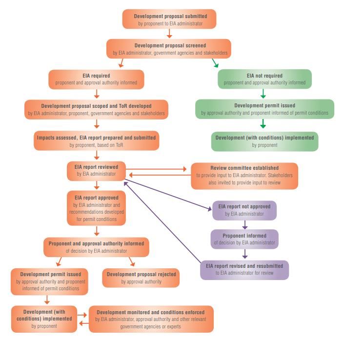
Internal use only

Table of Contents

1           Introduction                                                                         1
1.1         Guidance on EIA                                                                       1
1.2         Aims and Targets                                                                      1
1.3         This Guidance Note                                                                    2

2           The Pacific                                                                          3
2.1         Pacific Context                                                                       3
2.2         Pacific Approach                                                                      4

3           Coastal Engineering Project Types                                                    5
3.1         Dredging and Excavation                                                               5
3.2         Reclamation                                                                           6
3.3         Port or Harbour                                                                       6
3.4         Jetty or Boat Ramp                                                                    6
3.5         Breakwater                                                                            6
3.6         Seawalls, Groynes and Other erosion protection measures                               6
3.7         Beach Nourishment                                                                     7
3.8         Biomimicry                                                                            8

4           Supporting Studies                                                                   8
4.1         Physical Resources                                                                    9
4.1.1       Hydrographic survey                                                                  10
4.1.2       Geotechnical Investigation                                                           10
4.1.3       Metocean assessment (meteorology, tides and waves)                                   11
4.1.4       Coastal process modelling – hydrodynamic and morphodynamic                           11
4.1.5       Water quality monitoring and modelling                                               11
4.2         Biological Resources                                                                 12
4.2.1       Marine ecological survey and assessment                                              13
4.2.2       Terrestrial ecological survey and assessment                                         13
4.3         Socio-economic Resources                                                             13
4.3.1       Context                                                                              13
4.3.2       Heritage, or cultural, assessment                                                    13

5           Typical Impacts & Mitigation Strategies                                              14
5.1         Changes to Coastal Processes                                                         14
5.1.1       Potential effects                                                                    14
5.1.2       Mitigation strategies                                                                15

16 January 2022     COASTAL IMPACT ASSESSMENT GOOD PRACTICE   PA2846-RHD-02-GU-RP-EN-0001   ii
                    GUIDE
Internal use only

5.2         Changes to Marine Water and Sediment Quality                                          16
5.2.1       Potential impacts                                                                     16
5.2.2       Mitigation strategies                                                                 16
5.3         Benthic Communities and Habitats                                                      17
5.3.1       Potential impacts                                                                     18
5.3.2       Mitigation strategies                                                                 19
5.4         Marine Fauna and Avifauna                                                             20
5.4.1       Potential impacts                                                                     20
5.4.2       Mitigation strategies                                                                 21
5.5         Changes to Terrestrial Water and Sediment Quality                                     22
5.5.1       Potential impacts                                                                     22
5.5.2       Mitigation                                                                            22
5.6         Terrestrial Flora                                                                     23
5.6.1       Potential impacts                                                                     23
5.6.2       Mitigation strategies                                                                 24
5.7         Effects on Air Quality                                                                24
5.7.1       Potential impacts                                                                     24
5.7.2       Mitigation strategies                                                                 25
5.8         Noise Effects                                                                         25
5.8.1       Potential impacts                                                                     25
5.8.2       Mitigation strategies                                                                 26
5.9         Other Societal or Community Effects                                                   26
5.9.1       Potential impacts                                                                     26
5.9.2       Mitigation strategies                                                                 27

6           Effective EIA of Coastal Engineering Projects                                         29
6.1         Terms of Reference                                                                    29
6.2         Scoping                                                                               29
6.3         Stakeholder Engagement                                                                30
6.4         Monitoring, Management, and Enforcement                                               31

7           References                                                                            32

Table of Tables
Table 1: EIA parameters and data sources for the Ebeye seawall, RMI                               9

16 January 2022     COASTAL IMPACT ASSESSMENT GOOD PRACTICE   PA2846-RHD-02-GU-RP-EN-0001   iii
                    GUIDE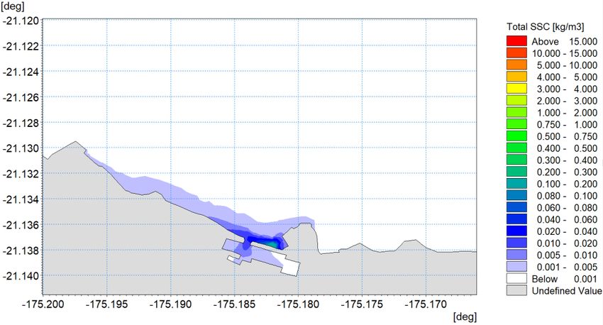
Internal use only

Table of Figures
Figure 1: EIA process                                                                            3
Figure 2: Green (‘soft’) and Gray (‘hard’) coast protection options (Source: (MfE, 2017) after
living-shoreline.pdf (noaa.gov))                                                                 7
Figure 3: Conceptual coastal process model of Nui’s southern coast, Tuvalu                       12
Figure 4: (a) Maximum surface total suspended solids (one-month simulation) without a silt
curtain and (b) sediment deposition thickness (two-month simulation) with a silt curtain,
Nukulaelae Port, Tonga                                                                           18

16 January 2022   COASTAL IMPACT ASSESSMENT GOOD PRACTICE    PA2846-RHD-02-GU-RP-EN-0001   iv
                  GUIDE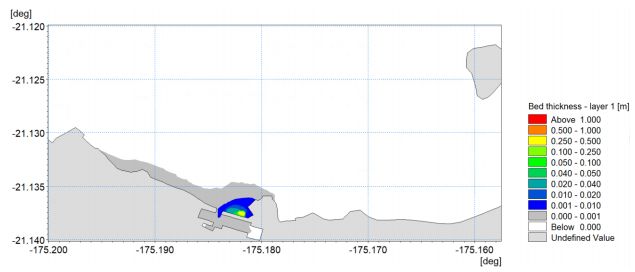
Internal use only

Glossary
Area of influence: the area affected by a              Cumulative impacts: changes in the
development project, which is beyond the project       environment resulting from the combined,
footprint. It may be upstream and/or downstream        incremental effects of past, present and future
of the project site and include the wider              human activities; environmental change (e.g.,
catchment, watershed, coastal/ocean zone,              climate change); and physical events. Physical
airshed or buffer zones; an off-site resettlement      events can be of natural or human origin and
zone; and areas that are culturally significant or     may include extreme weather events and natural
used for livelihood activities. The area of            or human-induced disasters.
influence is determined by a project’s resource
requirements and the nature and magnitude of           Disaster: severe, adverse disruption to the
its impacts, and it may vary across different          normal functioning of a community, society or
development phases of a project. Can also              ecosystem due to hazardous events interacting
referred to as a ‘zone of influence’.                  with vulnerable social and/or ecological
                                                       conditions. Can cause widespread human,
Baseline: a description of pre-development or          material, economic and/or environmental losses.
current environmental conditions of a project’s
area of influence. In assessing the ‘do-nothing’       Ecosystem-based management: an integrated,
(no development) scenario, an impact                   holistic approach to achieving environmental,
assessment should consider how the pre-                social and economic goals across “ridge-to-reef”
development baseline would evolve without the          or “whole-of-island” areas, typically combining
project.                                               land-use and development planning with
                                                       environmental protection and production needs.
Biomimicry: is a practice that learns from
and mimics the strategies found in nature to           Environment: encompasses natural and
solve human design challenges. It encompasses          biophysical, social (people, culture, health,
habitat creation (e.g., wetland creation) and          heritage, amenity) and economic aspects, and
translocation (e.g., coral gardens).                   the relationships between these different
                                                       aspects.
Climate change: long-term changes in climate
conditions, i.e., changes in the mean and/or the       Environmental hazard: an event or action that
variability of a property of climate, such as          has the potential to cause significant impacts on
precipitation, temperature or wind force. These        a community, society or ecosystem.
changes persist for an extended period, typically      Environmental hazards can be natural (e.g.,
a decade or longer. Climate change can                 cyclone, flood, earthquake, tsunami, volcanic
influence and alter the scale, scope, frequency        eruption, drought, landslide), human-induced
and intensity of disaster risks.                       (e.g., oil spill) or technological (e.g.,
                                                       infrastructure failure) in origin. They are not
Coastal development: any physical                      impacts (or disasters) in themselves but have the
development that occurs in the coastal                 potential to cause them.
environment or coastal zone (see below). Entire
islands may be in the coastal zone, especially if      Environmental impact assessment (EIA): a
they are small low-lying or atolls.                    process for identifying and managing a
                                                       development or project’s potential impacts on the
Coastal zone: the area over which the sea has          environment, and the potential impacts of the
an influence; with its inland extent typically taken   environment on a development. Refer to SPREP
to be Mean High Water Spring tides. This may           (2016) Strengthening environmental impact
be extend from the transition to upland forest out     assessment (EIA) guidelines for Pacific Island
to the reef edge.                                      countries and territories (PICT).

16 January 2022    COASTAL IMPACT ASSESSMENT GOOD PRACTICE     PA2846-RHD-02-GU-RP-EN-0001     v
                   GUIDE
Internal use only
Environmental impact assessment report Geographic Information System (GIS):
(EIA report) or environmental impact software used to spatially analyse
statement (EIS): the document prepared by or environmental, social, economic and engineering
on behalf of the development proponent as part datasets to help identify development risks,
of the EIA process, which details the project impacts and opportunities, and assess different
type, its timeframe and scale, likely impacts and development options. GIS can produce
impact significance, proposed impact mitigation informative visual materials (e.g. maps) to
measures (for negative impacts) and support stakeholder communication throughout
optimisation measures (for positive impacts), and the entire EIA process.
monitoring requirements.
Impact: a negative or positive change as a result
Environmental management plan (EMMP): a of an action, activity or event. Refers to the
project specific plan that describes all mitigation impact of a project on the environment, as well
measures and monitoring and reporting actions as the impact of the environment on a project
to be undertaken by the project proponent. An due to an environmental hazard or change.
EMMP should include a schedule and assign Examples of negative impacts include
responsibility to particular personnel (or roles) for degradation of ecosystem services, loss of life or
undertaking mitigation measures and monitoring injury, property or infrastructure damage, and
and reporting on a project’s environmental social unrest. Examples of positive impacts
performance to regulatory authorities. include environmental recovery and restoration,
increased food security, property or
Environment Officer: the member of the infrastructure improvements, and increased local
contractor’s team responsible for monitoring and job opportunities.
ensuring environmental performance. Generally
answerable to the PICT Department of Intertidal zone: is the area where the ocean
Environment. meets the land between high (MHWS) and low
(MLWS) tides. This zone is intermittently wet and
Environmental, social and cultural assets: dry. The subtidal zone is seawards of the
tangible and intangible assets that are valued intertidal zone and always wet.
and enjoyed by residents and visitors to the
Pacific. Examples of ‘environmental assets’ Mitigation: measures or actions taken by a
include areas of particular ecological project proponent to address the impacts
significance, national parks, community identified through the EIA process. Mitigation
reserves, protected areas, forests, mangroves, measures should follow the impact mitigation
seagrass beds, coral reefs, beaches, cliffs, hierarchy and be detailed in an EMMP. The
blowholes, rivers, waterfalls, streams, wetlands, mitigation hierarchy, in order of preference, is
freshwater springs, waterholes, as well as plants avoid negative impacts, minimise negative
and animals (especially species that are native, impacts that cannot be avoided, rehabilitate or
endemic or threatened). Examples of ‘social remedy negative impacts that cannot be
assets’ include land and other resources that minimised, and offset (or compensate for)
customary owners have given their approval to negative impacts that cannot be remedied.
share with local community groups and
networks, tourists, and local businesses, as well Noumea Convention: The Convention for the
as local knowledge, community facilities, utilities Protection of Natural Resources and
and transport. Examples of ‘cultural assets’ Environment of the South Pacific Region and its
include cultural heritage sites and environments, Protocols obliges Parties to endeavour to take all
physical structures, historical places, cultural appropriate measures to prevent, reduce and
knowledge and practices, museums and control pollution from any source and to ensure
collections, art and live performances. sound environmental management and
16 January 2022 COASTAL IMPACT ASSESSMENT GOOD PRACTICE PA2846-RHD-02-GU-RP-EN-0001 vi
GUIDEInternal use only
development of natural resources, using the best Stakeholder: any person, organisation,
practicable means at their disposal and in institution or business who has interests in, or is
accordance with their capabilities. Ten Pacific affected by, a development or project issue or
countries are Party to the Noumea Convention. activity, including local community members and
customary land/resource owners.
Project footprint: the land and/or ocean area
occupied by project buildings, facilities, Strategic environmental assessment: a
infrastructure or activities. higher-level assessment process that can be
used to: (1) prepare a strategic development or
Project proponent: an individual, company or resource use plan for a defined land and/or
government ministry/department/agency ocean area, (2) examine the potential
planning to undertake a development or project. environmental impacts associated with the
implementation of government policies, plans
Residual effects: those effects (or impacts) that and programmes, (3) produce general
are predicted to remain once mitigation has been environmental management policies or design
implemented. guidelines for different classes/types of
development. See SPREP (2020) Strategic
Resilience: the ability of a community or system Environmental Assessment (SEA) Guidelines for
(human and/or natural) to sustain itself, to PICT.
respond to and recover from extreme events and
disturbances, or to use extreme events and Vulnerability: the sensitivity of a development,
disturbances as an opportunity for renewal and human community or ecosystem to damage and
positive transformation. loss resulting from a hazardous event or
disturbance.
16 January 2022 COASTAL IMPACT ASSESSMENT GOOD PRACTICE PA2846-RHD-02-GU-RP-EN-0001 vii
GUIDEInternal use only
Abbreviations
ADB Asian Development Bank
CBD Convention on Biological Diversity
CLO community liaison officer
dB decibels
EIA environmental impact assessment
EIS environmental impact statement
EMMP environmental management plan
ERP emergency response plan
FRDP Framework for Resilient Development in the Pacific 2017–2030
GIS geographic information system
GRM grievance redress mechanism
HIV/AIDS human immunodeficiency virus / acquired immunodeficiency syndrome
IUCN International Union for Nature Conservation
LiDAR light detection and ranging remote sensing system
MEA multilateral environmental agreement
MCA multi criteria analysis
MHWS mean high water spring tides
MLWS mean low water spring tides
MSL mean sea level
NGOs non-governmental organisations
PICT Pacific Island countries and territories
PPE protective personal equipment
SDG United Nations Sustainable Development Goals
SEA strategic environmental assessment
SIA social impact assessment
SIDS small island developing states
SPREP Secretariat of the Pacific Regional Environment Programme
SSC suspended sediment concentration
STI sexually transmitted infection
ToR terms of reference
UNFCCC United Nations Framework Convention on Climate Change
UXO unexploded ordnance (typically associated with World War II)
16 January 2022 COASTAL IMPACT ASSESSMENT GOOD PRACTICE PA2846-RHD-02-GU-RP-EN-0001 viii
GUIDEInternal use only
1 Introduction
1.1 Guidance on EIA
Environmental impact assessment (EIA) is a process that is used to assess and manage individual
development projects, by identifying and mitigating the developments impact on the environment and the
environments impact on the development (or project). The EIA process aims to maximise positive benefits
and minimising negative impacts for local communities and their environment. When implemented
correctly, EIA can help to support the achievement of green growth targets, climate change resilience, and
the United Nations Sustainable Development Goals (SDGs)1.
Across the Pacific, the Secretariat of the Pacific Regional Environment Programme (SPREP) has been
promoting the use of EIA and delivering EIA capacity-building for more than twenty-five years. In 2016
SPREP member countries endorsed new regional EIA guidelines Strengthening environmental impact
assessment: Guidelines for Pacific island countries and territories (PICT) (SPREP, 2016). The Regional
EIA Guidelines provide a detailed overview of EIA and offer practical tips and tools to support PICT
government officers with managing the EIA process. They do not provide details on how to assess and
mitigate impacts from specific developments, including the many projects in the Pacific that entail coastal
engineering.
Coastal environments are biologically productive and ecologically diverse; they supply valuable resources
to support Pacific island lifestyles, livelihoods and cultural practices; and they provide critical natural
defences against storms, cyclones, tsunami, flooding and erosion, the frequency of which is expected to
increase with climate change. Coastal engineering projects can make a positive contribution to Pacific
island countries and territories as long as they are designed to ensure that important coastal areas are not
degraded and EIA can play an important role in ensuring this.
Given this, SPREP determined that guidance on good practice in EIA – scoping, data collection, impact
assessment, mitigation, and monitoring and management – for coastal development, adaptation and
engineering projects would be valuable and this report was born in line with Objective 4.1 of SPREP’s
Strategic Plan 2017–2026 2. The guidance provided is designed to support PICT governments in meeting
their obligations to undertake, require and review EIAs for coastal development, in line with the multilateral
environmental agreements (MEAs) to which they are party (Section 2.2).
1.2 Aims and Targets
The aims of the Coastal Impact Assessment Good Practice Guide are to:
1. Increase awareness and understanding of the EIA process across PICT.
2. Promote good practice in EIA for coastal engineering projects.
3. Encourage government agencies and developers to comply with national EIA regulatory
frameworks and, in the absence of these, to follow regional EIA guidance.
4. Support sustainable and resilient coastal development that protects environmental, social and
cultural assets.
1
THE 17 GOALS | Sustainable Development (un.org)
2
To “Strengthen national sustainable development planning and implementation systems including through use of Environmental
Impact Assessments, Strategic Environmental Assessments, and spatial planning”.
16 January 2022 COASTAL IMPACT ASSESSMENT GOOD PRACTICE PA2846-RHD-02-GU-RP-EN-0001 1
GUIDEInternal use only
The EIA guidelines are intended for:
• Government officers who are responsible for managing or providing input into the EIA process.
• SPREP members.
• Marine businesses and operators, both small and large.
• National marine and coastal development associations.
• Customary and private land and resource owners.
• Members of civil society organisations and local community groups who have an interest in
coastal development and EIA.
1.3 This Guidance Note
SPREP’s Strategic Plan 2017-2026 recognises that the people and environment of the Pacific benefit from
commitment to and best practice in environmental governance. Good environmental governance is
supported by regulation and a structured process for the environmental assessment of development, as
well as the mitigation of adverse effects, monitoring and appropriate environmental management. Each one
is dependent on the other and benefits from thorough but straight forward guidance.
The Regional EIA Guidelines (SPREP, 2016), as well as the EIA guidelines for coastal tourism
development in PICT (SPREP, 2018) and Strategic Environmental Assessment (SEA) Guidelines for PICT
(SPREP, 2020), have been effectively used in the Pacific and have facilitated improvements in EIA
processes, its management and awareness. They have built capacity, but the broad descriptions provided
are limited regarding the specific assessment of coastal development and adaptation projects and in the
design of associated mitigation and management measures. With the challenges presented by climate
change (including drought, floods, coastal erosion / inundation and salinisation) and the vulnerability of
PICT, such projects will only become more important and need to be assessed appropriately.
SPREP 2016 provides guidance on the general EIA process for PICT by:
• Emphasising the importance of assessing the potential impacts of development on the
environment and the potential impacts of the environment on development, especially impacts
related to climate change and disasters.
• Providing a clear overview of the EIA process, supported by an Environmental management
Plan (EMMP) toolkit that includes templates and checklists for EMMP scoping, mitigation
measures, reporting, monitoring, and review.
• Providing information on the type of baseline studies that are required to support certain
investigations and the forms of assessment that are appropriate (or can be applied, e.g., where
there is a lack of resources) in different circumstances.
• Introducing the concept of SEA, an approach that provides context for EIA by identifying what
forms of development are environmentally sound and appropriate; pinpointing locations where
developments are/are not permissible; stipulating desired types and characteristics of
developments; and identifying broad environmental management measures that are advocated.
• Setting out considerations and recommendations for effective EIA in the Pacific.
• Providing guidance to Pacific Island countries should they wish to develop their own national EIA
guidelines.
• Linking the EIA process to MEAs.
The general approach to impact assessment advocated is consistent across the SPREP documents and
the SPREP core priority areas – of climate change resilience, island and ocean ecosystems, effective
waste management and pollution control and environmental governance – are evident. This Good
Practice Guide does not make alterations to this established EIA process (shown in Figure 1), rather it
builds upon it, with a specific coastal engineering, adaptation and management focus. It aims to provide
specific examples, approaches and mitigation measures relevant to the coastal environment.
16 January 2022 COASTAL IMPACT ASSESSMENT GOOD PRACTICE PA2846-RHD-02-GU-RP-EN-0001 2
GUIDEInternal use only
Figure 1: EIA process
2 The Pacific
2.1 Pacific Context
The Pacific Ocean covers one third of the Earth’s surface and is one of the world’s largest active carbon
sinks. It has an immense biodiversity, with as little as 20% of its flora and fauna having been properly
researched. The Pacific Islands are characterised by extremes in physical geography and remoteness.
For example, Tuvalu consists of six coralline atolls (Nanumea, Nui, Nukufetau, Funafuti, Nukulaelae,
Vaitupu) and three table reef islands (Nanumaga, Niutao, Niulakita), with a total land mass of some 26km 2
spread across an economic zone of 757,000km2, which is more than 1,100km from its closest neighbour,
Fiji. The environmental profile of the region is one of high degrees of endemism and levels of biodiversity,
16 January 2022 COASTAL IMPACT ASSESSMENT GOOD PRACTICE PA2846-RHD-02-GU-RP-EN-0001 3
GUIDEInternal use only
but relatively small numbers of species. There is a high degree of economic and cultural dependence on
the natural environment and a clear vulnerability to climate change and a wide range of natural disasters
(Mimura, 1999). The social profile of the region, in the context of EIA, is one of high levels of education but
a lack of direct experience and resource sharing (rather than specialisation).
The Pacific region is blessed with coral reefs and their ecosystems. More than 80% of Pacific islanders
live in or near coastal areas and draw from the coral reefs for their livelihood. The reefs support
approximately 25% of all marine life, including over 4,000 species of fish, providing valuable spawning,
nursery, refuge and feeding areas for large varieties of organisms. Coral reefs also play vital roles as
natural breakwaters, minimising wave impacts during storms and cyclones (Marto, Papageorgiou, &
Klyuev, 2017).
At the regional level, the inter-relatedness of the economic and ecological characteristics of the islands is
manifest in several areas. Natural resources, such as water, vegetation, soil, near-shore systems, and
wildlife, ultimately dictate the capacity of islands to accept and sustain development. For islands, resource
productivity is intricately linked to the function of neighbouring ecosystems, such that damage to one
ecosystem invariably impacts on other ecosystems, and to a much greater degree than is the case for
continental societies.
Pacific nations rank among the most vulnerable in the world to natural disasters. Between 1950 and 2004,
extreme natural disasters, such as cyclones, droughts, and tsunamis, accounted for 65 percent of the total
economic impact from disasters on the region’s economies. Further, ten of the fifteen most extreme
events reported over the past half century have occurred in the last fifteen years (Rahman, 2016).
2.2 Pacific Approach
From the late 1980s onwards, EIA awareness and application began to be widely promoted in regional
and international MEAs, to which many SPREP members are party, such as the:
• Convention for the Protection of the Natural Resources and the Environment of the South Pacific
Region (Noumea Convention);
• Rio Declaration on Environment and Development (Rio Declaration);
• Convention on Biological Diversity (CBD); and,
• United Nations Framework Convention on Climate Change (UNFCCC).
In the years that have followed, EIA has been adopted and legislated by most countries around the world
and used to assess both public and private development projects. In the Pacific, project-scale EIA was
initially introduced in association with projects
funded by the Asian Development Bank and
The World Bank. During the 1990s and 2000s,
Pacific countries started to incorporate EIA into Nassau, The Cook Islands
their national environmental policies and
legislation. SPREP helped to facilitate the EIA requirements can change in PICT based on
uptake of EIA by providing educational traditional governance structures and should always
be checked at both a National and island /island group
publications and training, hands-on assistance. level.
All Pacific island countries, with the exception of
For example, The Cook Islands Environment Act 2003
Nauru, now have legislation in place that does not apply on the remote island of Nassau (or on
provides substantive provisions for EIA two other Cook Islands) because the Island has a
traditional leader in place, with a higher status than
application. However, despite the widespread the Government, and is governed by traditional rule .
adoption of EIA, a number of countries are still Hence the EIA undertaken for their Harbour
learning how to use the tool to maximum effect; improvement took the form of an ‘Environment
Report’ (not an EIA under the 2003 Act).
especially within the context of staffing, financial
and technical resource constraints, and in terms
16 January 2022 COASTAL IMPACT ASSESSMENT GOOD PRACTICE PA2846-RHD-02-GU-RP-EN-0001 4
GUIDEInternal use only
of the need to comprehensively assess and address the social impacts of development and the potential
impacts the environment may have on development.
Most SPREP member countries and territories have EIA legislation, thus, EIA is a compulsory part of their
development planning and assessment processes, but experience in its application is limited. The EIA
process is commonly applied or triggered as a legal requirement for gaining development approval, or at
the request of funding agencies and financial lending institutions who seek to encourage sustainable and
accountable development.
3 Coastal Engineering Project Types
For ease, ‘coastal engineering’ is used herein as a catch all for coastal engineering, coastal management,
and coastal adaptation projects.
Coastal engineering involves the planning, design, construction and maintenance of works aimed at
protecting or adapting shorelines, reclaiming land from the sea, countering subsidence, facilitating
navigation and providing marine facilities, and ecosystem enhancement and restoration. Broad categories
of coastal engineering activities and projects typical of the Pacific region are described below.
3.1 Dredging and Excavation
Dredging typically involves removing
sediment (sand, silt and mud) from below Nui Small Boat Harbour, Tuvalu
water to create the required depth for the
safe navigation of vessels or to win material
(sand) as a resource. Excavation typically Dredging will include the removal of sand and rock
from the bottom of the channel and the removal of
involves removing rock or coral platforms to solid coralline rock from the side walls, to create a
achieve the required depth for safe turning basin within the reef platform. The proposed
channel has been aligned to maximize its overlay with
navigation or to enable the construction of a the existing channel to minimize the dredging
jetty or harbour. Dredging and excavation are requirements of the project and reduce its
environmental impact.
a common part of coastal development
projects in the Pacific due to the reliance on The length of the existing channel will not change but
the last 300m from the mouth will be enlarged to be
marine transport and the requirement to a minimum of 20m and up to 40m wide in the turning
provide access for vessels to land though basin and at its mouth to allow for safer access for
small passenger vessels/work boats.
coralline platforms and table reefs.
The channel will be dredged to a maximum depth of -
The impact of mining beach sand and other 3.30m below mean sea level (MSL) at its mouth, with
aggregates for construction purposes on two steps up to a level of -2.5m below MSL in the
turning basin. These depths have been determined
Pacific islands has significantly affected based on the tidal variation within the channel to
coastal processes and their coastal ensure there is sufficient under keel clearance for the
workboats at mean low water spring tides (MLWS).
environments. Consequently, in most Pacific
countries and territories, the removal of The dredging will be carried out by 40- or 50-ton
excavators using a hydraulic rock breaker and bucket
beach gravels and sands is now restricted. In attachments for the removal of th e reef material,
Tuvalu, no person shall remove from the rather than the use of a grinder/suction head due the
marginal economics of mobilizing such equipment for
foreshore any sand, gravel, reef mud, coral a remote island. Dredging from the reef platform
or other like substances without having first would be limited to low tidal conditions , which would
obtained a license for that purpose from the limit the plume, whereas dredging from a floating
barge could occur for longer periods.
Kaupule in whose area of authority such
foreshore lies, and licenses will only be
provided for personnel use (e.g., house
building).
16 January 2022 COASTAL IMPACT ASSESSMENT GOOD PRACTICE PA2846-RHD-02-GU-RP-EN-0001 5
GUIDEInternal use only
3.2 Reclamation
Reclamation is raising the seabed or intertidal zone below the high-water mark above the high-water mark
by depositing solid material that creates land on top of previously marine or coastal environment. The
placement of such material typically needs to be contained by pilled walls, rock armour or rock
baskets/bags. Many Pacific islands are constrained by lack of available land, meaning that reclamation
may be viewed as an option to alleviate this. Reclamation (and land raising) may also be undertaken as
an adaptation strategy due to sea level rise.
3.3 Port or Harbour
A port or harbour is an essential node in a
supply chain. Most Pacific countries or Maritime Transport Master Plan, Tonga
territories have one major port that serves
as its international hub for imports and
Due to Tonga’s relative isolation, spatial dispersion
exports and is of critical importance, over a large area of the South Pacific and
representing a vital link for Pacific islands to dependence on imports, international, regional,
other regions. Many other islands have internal transport links are crucial. But in 2022 28%
of its islands either have no wharfs or wharfs with
harbours via which goods and services are
significant damage that cannot be functionally used;
transhipped. This includes the movement of 22% of its islands have wharfs that are significantly
people for essential health care, education, damaged but still functional (although not safe) ; and
and social and cultural events. Some 22% if its islands have wharfs that have moderate
damage, which impacts their function.
islands have neither. Port and harbours
typically include fully enclosed (walled),
reclaimed areas and piled structures.
3.4 Jetty or Boat Ramp
By contrast to a port or harbour that may allow an interisland vessel to moor or, if small, work boats to
moor (which transfer people and goods from the vessel to the harbour), many islands have simple piled
jetties that can only accommodate small boats for the transfer or people and goods to and from work
boats in the open ocean. Some islands simply have boat ramps, which may be concrete structures or flexi
mats pinned to the seabed.
3.5 Breakwater
A breakwater is a coastal structure (usually a rock and rubble mound structure) projecting into the sea that
can shelter vessels from waves and currents, prevent siltation of a navigation channel or protect a shore
area. Breakwaters are mostly associated with marine facilities such as harbours or jetties.
3.6 Seawalls, Groynes and Other erosion protection measures
Hard structures are frequently constructed to prevent erosion of coastal landscapes and infrastructure and
mitigate the risks to populations and economic activities. Coastal structures are usually built using
materials (at least for certain coasts and beaches) that do not form naturally, such as concrete, large
armour stone, steel (steel baskets and rock), or timber, are relatively permanent (typical with a 50-yr
design life) and are spatially fixed within an otherwise dynamic coastal zone (see Figure 2); the
consequence of which will often be the loss of the beach overtime.
Seawalls are onshore structures with the principal function of preventing erosion or alleviating overtopping
and flooding of the land and the structures behind due to storm surges and waves. Seawalls are built
parallel to the shoreline as a reinforcement of a part of the coastal profile. Quite often, seawalls are used
16 January 2022 COASTAL IMPACT ASSESSMENT GOOD PRACTICE PA2846-RHD-02-GU-RP-EN-0001 6
GUIDEInternal use only
to protect promenades, roads, and houses seaward of the crest edge of the natural beach profile.
Seawalls range from vertical face structures (such as gravity concrete walls, tied walls using steel or
concrete piling, and stone-filled cribwork) to sloping structures with typical surfaces being reinforced
concrete slabs, concrete armour units, or stone rubble.
Figure 2: Green (‘soft’) and Gray (‘hard’) coast protection options (Source: (MfE, 2017) after living-shoreline.pdf
(noaa.gov))
Groins are built perpendicular to the shore to stabilize a stretch of natural or
artificially nourished beach against erosion that is due primarily to a net longshore
loss of beach material. Groins function only when longshore transport occurs. Groins
are narrow structures, usually straight and perpendicular to the pre-project shoreline.
The effect of a single groin is the accretion of beach material on the updrift side and erosion on the
downdrift side; both effects extend some distance from the structure.
Detached breakwaters are small, relatively short, non-shore-connected nearshore breakwaters with the
principal function of reducing beach erosion. They are built parallel to the shore just seaward of the
shoreline in shallow water depths, using solid concrete structures, piles of stone/concrete blocks, or rubble
mound. Multiple detached breakwaters spaced along the shoreline can provide protection to substantial
shoreline frontages.
Soft engineering includes engineering approaches to set back and stabilise dunes or planting (in a
geotextile matrix or similar) and focusses on retaining the natural defences (through dune management,
maintenance of sediment supply, maintaining healthy foreshore vegetation and wetlands, managing
access and so on). It may include a buried revetment or seawall.
3.7 Beach Nourishment
Beach nourishment, or beach filling, is the practice of adding often large quantities of sand or sediment to
beaches to combat erosion and increase beach width. Often referred to as a “soft armouring” technique, it
is sometimes viewed as a superior alternative to hard armouring. With sea level rise and storms
16 January 2022 COASTAL IMPACT ASSESSMENT GOOD PRACTICE PA2846-RHD-02-GU-RP-EN-0001 7
GUIDEInternal use only
threatening to erode sandy beaches, it is likely that nourishment will become more prevalent. However,
this approach will be limited in the Pacific by the availability (or lack of availability) of sand.
3.8 Biomimicry
In the context of coastal engineering projects in
PICT, biomimicry can take the form of
Seagrass restoration, Kiribati
constructed wetlands, seagrass restoration,
coral gardens, artificial reefs and planted The Seagrass Restoration Guidelines for Kiribati
mangrove forests. [REF] discuss the multitude of methods
available for undertaking restoration works.
Constructed wetlands are frequently designed However, whether the proposal involves
to restore natural wetland habitats and restoring seagrass beds, mangrove forests or
wetlands, the considerations are similar. In
ecosystems but can serve other purposes, often
brief, the proponent should consider:
related to water or sewage filtration and
treatment (as alternatives to more industrial • Site selection and habitat suitability -
environmental conditions suited to the
processes). Natural wetlands and seagrass growth of the selected species.
beds support significant biodiversity and • If there are suitable donor sites to populate
particularly fish. the restoration area.
• Community participation - utilising local
Coral gardening is a method of growing knowledge of the species and what is
translocated coral polyps to help restore reefs. needed for it to thrive.
Sometimes called coral farming, this gardening • Scale - larger areas are more likely to
succeed than small areas .
method involves taking small coral fragments
• Cost - is it feasible to attempt the
and growing them through asexual reproduction restoration?
until they are mature. Ocean-based nurseries
take coral fragments and grow them
underwater. They attach the pieces to steel structures and monitor them, with the view to transplanting
coral into degraded natural reefs.
An artificial reef is a human-made underwater structure that closely approaches or extends above the
surface of the water. These reefs provide excellent habitats for marine life and are often built specifically
for this purpose. In addition, reefs can protect nearby beaches from erosion.
If such measures are proposed as part of a mitigation strategy for a coastal engineering project, they must
be supported through a long-term management programme and expert knowledge.
4 Supporting Studies
To assess the environmental effects of coastal engineering projects, similar studies are typically required
to identify sensitive receptors and quantify potential impacts. These studies are discussed below.
A guide such as this cannot provide specific details of the level of investigation or detail required by a
specific project, but it is important to be proportionate in determining survey requirements (i.e., where an
effect is expected to be limited, the surveys commissioned can be higher level, whereas if an effect is
expected to the significant detailed modelling (e.g., dredged plume modelling) may be required). Section
6.2 on Scoping provides further details. In some cases, a desktop study of available evidence can usefully
be undertaken as a first step to determine the requirement, or not, for further investigation. Table 1
provides an example of the environmental and social topics on which data was sought and the data
sources for a coastal protection project in Ebeye, the Republic of the Marshall Islands (RMI).
Where feasible and/or appropriate, the use of standardised data collection methods and presentation
formats should be encouraged, so that the same level of rigour applies across all developments.
16 January 2022 COASTAL IMPACT ASSESSMENT GOOD PRACTICE PA2846-RHD-02-GU-RP-EN-0001 8
GUIDEInternal use only
Developers should also be encouraged to present EIA data in a spatial format (using a GIS), to assist with
understanding the physical location and extent of a development, and the scope and scale of impacts.
Table 1: EIA parameters and data sources for the Ebeye seawall, RMI
EIA parameter (topic) Source of information
Physical Environment
Field studies (geotechnical survey); published data on ‘borrow
Geological Resources – soils, sands, reef flat, freshwater lens
pits’ (aggregate extraction sites)
Coastal Processes – waves, water levels, tides and
Desktop studies; site observations; numerical modelling
erosion/sediment transport
Bathymetry and Topography Field survey; LiDAR data
Wind and Temperature Sourced from closest weather station
Natural Hazards – cyclones, tsunamis, volcanic activity and
Desktop studies
earthquakes
Desktop studies; Pacific Climate Change Science Program of
Climate Change – sea level rise, rainfall, cyclonic intensity
Australia - RMI
Noise Baseline noise sampling during site investigations
Air Quality (dust) Baseline dust sampling during site investigations
Biological Environment
Terrestrial Ecology – flora, fauna and land use Aerial imagery; CBD Reports (RMIEPA); ecological survey
Marine Ecology – coral reef health, fish/reptile/mammal LiDAR imagery; ecological survey; coral reef mapping; State of
assemblage, intertidal reef flat, marine ecosystem services Environment Report (SPREP)
Protected Areas – nationally protected, community managed Pacific Islands Protected Area portal – SPREP; local
and area uses government databases
Vulnerable and Endangered Species – endemic, rare and IUCN Red List; CBD Reports; State of Environment Report
valuable species (SPREP)
National Biodiversity Strategy and Action Plan; National
Invasive and Alien Species
Invasive Species Action Plan; stakeholder engagement
Social Environment
Stakeholder consultation; land records, lease records, land
Landownership and Land Use
agency; satellite imagery
Demographics and Education Census data; key informant interviews
Health and medical services and facilities Desktop studies; key informant interviews; focus groups
Gender Gender and Development Office consultation; focus group
Economy and Employment Census data; informant interviews/focus groups; ADB reports
Cultural Resources Desktop studies; consultation with traditional leaders
Vulnerable Persons – youth, elderly, disable persons Desktop study; focus groups discussions
Development Project Reports; Development Plans; key
Infrastructure and Utilities
informant interviews
4.1 Physical Resources
As for most EIAs, an EIA for a PICT coastal engineering project will begin with a description of the
physical resources of the study area, including its geology, topography, hydrography, reefs, and soils.
In the Pacific, it is also relevant to consider seismicity and volcanic activity. Of equal importance will be
metocean and hydrodynamic conditions (coastal processes), and climate (including tropical cyclones) /
16 January 2022 COASTAL IMPACT ASSESSMENT GOOD PRACTICE PA2846-RHD-02-GU-RP-EN-0001 9
GUIDEInternal use only
Hydrographic Survey Methods
climate change – sea level rise but also
increased storminess, increased intensity and
A variety of methods can be employed to determin e
frequency of rainfall and heat, and incidence horizontal location and vertical depth, however,
of drought. global positioning systems (GPS), using differential
or real time kinematic (RTK) corrections via an
electronic single beam or multibeam echosounder,
4.1.1 Hydrographic survey are the most common method for collecting
hydrographic data. A weighted line and a survey
A hydrographic survey maps the terrain of the tape can also be used.
sea floor (bathymetry) by determining the
Multibeam echosounders transmit sound signals
depth of an overlying water body. and analyse the return signal that has bounced off
Hydrographic surveys are used for a range of the seafloor or other objects. Multibeam sonars
applications in coastal engineering projects, emit sound waves from directly beneath a ship's
hull to produce fan-shaped coverage of the
including estimating sediment volumes during seafloor. Thes e systems measure and record the
dredging, charting and ship navigation, and time for the signal to travel from the transmitter to
understanding nearshore/offshore coastal the seafloor and back to the receiver. Multibeam
surveys are the most expensive survey method but
processes.
provide the clearest picture. It is the quickest
Hydrographic surveys may include the collection method for large areas; however, more
processing time is required than for other methods.
following:
With single beam echosounders the sound is
• A survey plan to define the extent of the transmitted straight down in a focused beam,
data to be collected. typically a 3-20° cone. This yields a single depth
measurement from somewhere inside the ‘beam’.
• Physical field survey by an appropriately
Taken in a continuous string, a single beam
qualified surveyor. echosounder produces a seafloor profile. Single
• Data analysis and reporting. beam echosounder do not record the average depth
• Data outputs that may include 2D and/or within the area of the beam on the seafloor. Rather
the first sound return for each "ping" provides the
3D mapping as well as data files for GIS depth. Therefore, the shallowest depth within the
input. cone is recorded. In areas with a rough seafloor
and/or large relief, this means that the "least
depth" within the cone of transmitted sound is
4.1.2 Geotechnical Investigation recorded, which can reduce accuracy. Single beam
surveys are the most cost -effective way to obtain a
The purpose of a geotechnical investigation is survey of an area. These surveys can be collected
to understand the ground conditions below a and processed quickly when the equipment is
development site. This will generally aim to available.
understand the properties and distribution of
geological units within the area for use in Leadline surveys have a long history in the
maritime sector. This kind of manual survey has
engineering design, construction or
been replaced by echosounding for the most part,
infrastructure planning. due to the improvements in data collection speed,
accuracy and point density. Leadline surveys will
A geotechnical investigation may include the
generally require a boat, a surveyor’s tape to
following: measure range along a station, a weighted line
• Desk study: a review of available marked to measure depth and an accurate tide
gauge. Leadline surveys are a good alternative in
information and data prior to an on-site situations when the equipment and resources do
investigation. not allow for an echosound survey or the area to be
• On-site investigations: including drilling, surveyed is small.
test pitting, in-situ testing etc.
• Laboratory testing: testing samples
recovered from on-site investigations.
• Factual reporting: geotechnical logs, laboratory results and investigation methodologies.
• Interpretive reporting: reporting containing interpretation of the investigation results (e.g., design
parameters, geotechnical construction advice, and geological cross sections).
The requirements of a geotechnical investigation will differ depending on the design requirements of a
project, site conditions, available information, and site constraints. Generally, on-site geotechnical
16 January 2022 COASTAL IMPACT ASSESSMENT GOOD PRACTICE PA2846-RHD-02-GU-RP-EN-0001 10
GUIDEInternal use only
investigations are not required to inform an EIA (desk study information is typically sufficient) but further
detail can be informative.
4.1.3 Metocean assessment (meteorology, tides and waves)
Metocean refers to the study of meteorology and physical oceanography. In a coastal engineering context,
these studies are primarily used to measure and assess wind, wave, tides, storm tides and climatic
conditions that may influence a particular area and/or project.
A metocean study can be incorporated at various stages of coastal engineering projects but is typically
undertaken in the early stages of a project to assist with defining design criteria, ranging in complexity
from simply understanding the broad metocean conditions to providing detailed assessment of specific
conditions (e.g., strength of cyclones, tidal influence, storm surge impact etc.).
Metocean assessments should aim to include the following:
1. Project definition (i.e., scope, objectives).
2. Collection and analysis of field data or data from established suitable global models (e.g.,
WaveWatch III).
3. Development of a ‘conceptual’ site model (assessing all influencing parameters).
4. Model selection, development, and calibration/uncertainty analysis.
5. Assessment of model predictions and outcomes to inform project design.
Metocean information on wind, waves, tides is required to inform EIA of coastal engineering projects, but
existing information is often available and sufficient. Typically of more importance is hydrodynamic
modelling, which requires metocean inputs, to predict the influence of any new structure in the coastal
zone on coastal processes and, from this, on sedimentary process, water quality, ecology etc.
4.1.4 Coastal process modelling – hydrodynamic and morphodynamic
Hydrodynamic modelling is the study of fluids in motion. Many forces can be responsible for fluid motion,
either acting alone or in combination with each other. In a coastal engineering context, these forces are
typically generated by tides, winds and waves, together with topographic gradients and bodies of water
meeting, such as oceans, rivers, wastewater outlets etc. Coastal morphodynamic (or geomorphodynamic)
modelling refers to the study of the interaction and adjustment of the seafloor or coastal topography and
hydrodynamic processes (or forces), involving the motion of sediment. Seabed features and structures will
be impacted directly by hydrodynamic motion generated by these forces, which in turn will affect the fluids
behaviour and hydrodynamic and morphodynamic processes (sediment transport).
A change in a forcing factor (such as the direction and strength of a tidal current due to the construction of
a breakwater) does not mean that an impact will occur, but if that change affects water quality or
sedimentary processes, then an impact may arise (typically on local ecology).
Coastal process modelling facilitates the understanding and quantification of these complex interactions
and enables the development of effective coastal infrastructure. It is fundamental to coastal engineering
EIA and typically includes the five steps set out above for metocean assessment. But, again, the effort
invested in such should be proportionate to the effects predicted. For a major Port development or vertical
seawall, a detailed hydrodynamic model and sediment transport assessment should be undertaken. For a
jetty or boat ramp, or soft engineering solution, a conceptual coastal process model may be sufficient (see
Figure 3).
4.1.5 Water quality monitoring and modelling
The purpose of water quality monitoring is to provide data on the health of water bodies and facilitate the
effective management of catchments, water resources and the environment. Fundamentally, monitoring
16 January 2022 COASTAL IMPACT ASSESSMENT GOOD PRACTICE PA2846-RHD-02-GU-RP-EN-0001 11
GUIDEInternal use only
consists of a systematic and planned series of measurements or observations that are appropriately
analysed and reported, to generate information and knowledge about a water body.
Figure 3: Conceptual coastal process model of Nui’s southern coast, Tuvalu
As a general approach, a water quality monitoring study may include the following:
• Setting objectives, including defining water quality objectives for construction and operational
phases of a project (e.g., suspended sediment levels in a defined area are not to exceed 10% of
the range of the levels typically encountered in the water body for a defined time).
• Establishing the parameters and locations to be monitored (i.e., vis-à-vis sensitive receptors).
• Field sampling (of the baseline, during and post works conditions).
• Laboratory and data analysis.
• Reporting and modelling (if relevant).
Modelling water quality can be a useful tool in predicting and presenting the position and momentum of
possible pollutants in a water body and can inform EIA where this is a significant risk.
4.2 Biological Resources
Ecological survey and assessment will facilitate the identification, prediction and evaluation of potential
ecological impacts resulting from a project. The assessment should seek to protect and conserve the
ecological value within and surrounding the project site. Generally, its content will be defined based on the
environment potentially impacted and the type and scale of the project. The following will be included:
16 January 2022 COASTAL IMPACT ASSESSMENT GOOD PRACTICE PA2846-RHD-02-GU-RP-EN-0001 12
GUIDEInternal use only
• Desk based assessment of available data.
• Baseline ecological survey – the scope of which will vary dependent on the identification of
sensitive and/or important habitats and species (about which more may need to be known).
• Identification of ecological sensitive receptors.
• Evaluation of the significance of potential impacts on sensitive receptors
• Recommendations for mitigation measures and monitoring (if applicable).
4.2.1 Marine ecological survey and assessment
For coastal engineering projects in PICT, a marine ecological survey of the beach, reef platform, reef
edge, reef crest and reef slope is likely to be essential. That is, it should cover the project footprint and
area of influence (based on the coastal process and water quality assessment). This could include
offshore mooring sites. Such surveys will need to be undertaken through a combination of walking, wading
snorkelling and diving (depending on conditions). A manta tow approach (via a boat) may be used where
sea conditions are rough.
The focus of the survey should be on the benthic substrate and species (and in particular corals), fish,
macroalgae, invertebrates and (in some cases) cetaceans; and threatened and protected species.
4.2.2 Terrestrial ecological survey and assessment
A terrestrial habitat survey is also likely to be required, dependent on the scope of the project, and should
typically focus on the identification of endemic habitats and species – flora, fauna and avifauna.
4.3 Socio-economic Resources
4.3.1 Context UXO desktop, Niutao, Tuvalu
In the Pacific, population, education, health and
health infrastructure; livelihoods, subsistence and Tuvalu was used as a staging base for US aerial
incomes; land tender, ownership and use; attacks in the Battle of Tarawa in Kiribati during
World War II. Bomber bases were established on
transport, energy, water supply/sanitation and Funafuti, Nanumea and Nukufetau, being the
waste management infrastructure; and cultural only islands big enough to accommodate them.
resources (particularly grave sites at the coast) Funafuti, Nanumea and Nui were the only
are all of relevance. Each island typically has its islands to be bombed.
own governance structure and expectations Milsearch undertook historical desk -top
regarding gender and respect, that need to be research into military activities that may have
resulted in the presence of UXO on Niutao
understood in the development of social impact Island. This found that VMF-422 squadron
mitigation strategies. ditched the USMC F4U-1D Corsair aircraft onto
Niutao Island’s western foreshore. However, it
Although coastal engineering projects may affect was determined that this does not represent a
air quality and the noise environment of PICT, UXO risk to the island or the Tuvalu Outer
baseline air quality and noise surveys are Island Maritime Infrastructure Project.
generally not warranted where air quality is Historical records indicate that Niutao Island
expected to be very good and noise levels limited was not impacted by any other event able to
(i.e., the baseline is easy to quantify). generate remnant World War II UXO
contamination on the island, or its immediate
surrounds. Further risk assessment was not
4.3.2 Heritage, or cultural, considered to be necessary nor recommended.
assessment
The purpose of a heritage impact assessment is to identify and evaluate the potential impacts of a
proposed development on the cultural significance of a place. Typically, a heritage impact assessment
16 January 2022 COASTAL IMPACT ASSESSMENT GOOD PRACTICE PA2846-RHD-02-GU-RP-EN-0001 13
GUIDEYou can also read