Release Guide - Hexagon AB
←
→
Page content transcription
If your browser does not render page correctly, please read the page content below
Release Guide
                              2021.0

Release Guide
LuciadFusion 2021.0

10 June 2021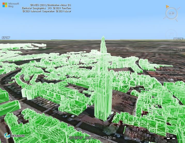
Contents
About this release ........................................................................................................................... 3
Benefits of the new features ........................................................................................................... 4
   Support for Apache Maven ............................................................................................................ 4
      Sample code to get you started .................................................................................................. 4
   Crawl and serve Hexagon Smart Point Cloud data ........................................................................ 5
      Sample code to get you started .................................................................................................. 5
   Crawl and serve ECW data as ECWP............................................................................................ 6
      Sample code to get you started .................................................................................................. 6
   Add your own custom service type ................................................................................................. 6
      Sample code to get you started .................................................................................................. 7
   Support for the Normaal Amsterdams Peil vertical datum .............................................................. 8
   MrSID format update...................................................................................................................... 8
   Other improvements ...................................................................................................................... 9
About Hexagon .............................................................................................................................. 10

10 June 2021                                                                                                                      2
About this release
The 2020.1 release of LuciadFusion puts the developer at the center of everything. LuciadFusion now
offers support for Maven and an API to manage and set up your own custom services. Two new
service types have been added as well: ECWP and HSPC, focusing on better integration with other
Hexagon products. Moreover, we updated our support to include some new formats and references.

                                Figure 1: The Luciad Product Portfolio.

10 June 2021                                                                                      3
Benefits of the new features
Support for Apache Maven
Maven1 is a development project management and build automation tool. It facilitates managing the
components and dependencies of your software project.
The 2021.0 release of LuciadFusion includes a set of scripts and Project Object Model (POM) files for
all libraries within the product distribution. Convenience POM files reflecting the product structure with
its tiers and optional components have been added. Support for obfuscation is also included.
Sample code to get you started
To get you started, we have created a step-by-step guide: “Using LuciadFusion in a Maven
repository.” This is part of a new section on Maven in the product documentation.
The release also includes example scripts that illustrate how to set up a project based on the
LuciadFusion samples.

         Figure 2: An example script illustrates how to set up a project based on the LuciadFusion samples.

1
    http://maven.apache.org/

10 June 2021                                                                                                  4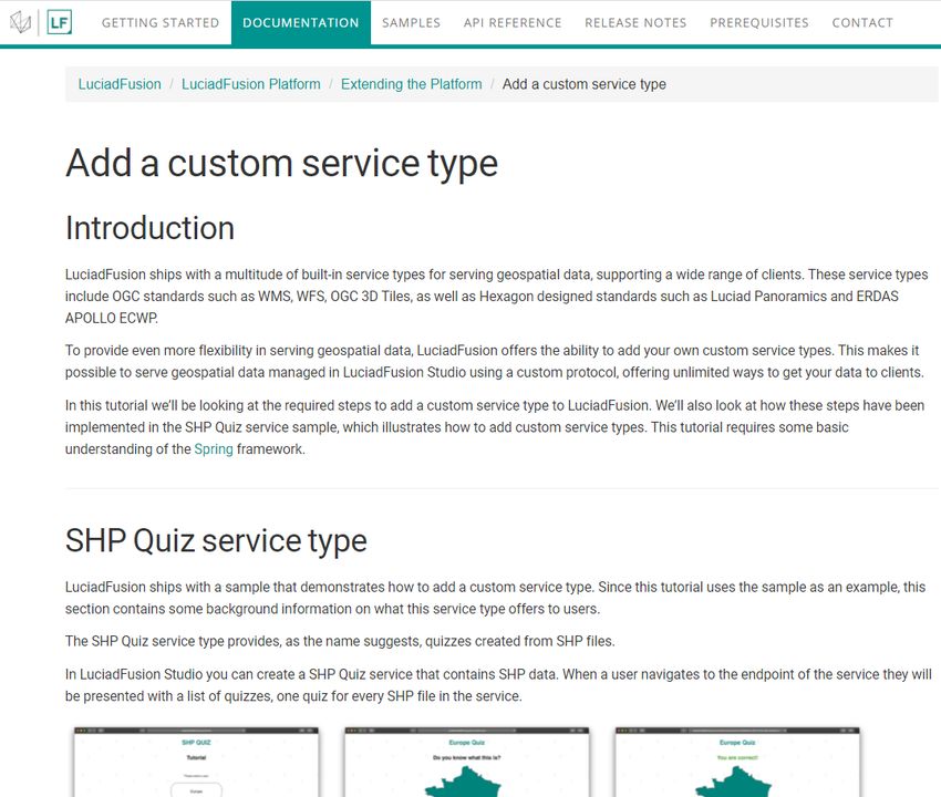
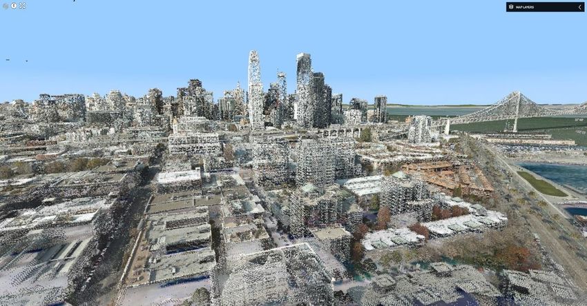
Crawl and serve Hexagon Smart Point Cloud data
LuciadFusion now directly supports point clouds in the Hexagon Smart Point Cloud format (HSPC).
Certain Hexagon scanners allow exporting point clouds in HSPC, a 3D-tiled format. Hexagon
customers can avoid additional conversion steps into LAS, E57, or OGC 3D Tiles. Advantages
compared to OGC 3D Tiles are better compression of the tile payload and precise encoding of the
point locations.
A new HSPC service type has been added to LuciadFusion. This means that data in the HSPC format
can be served as HSPC service, preserving all the benefits of the HSPC encoding. Note that
LuciadRIA offers a direct connector for HSPC services.
Sample code to get you started
The new HSPC service type is illustrated via the integration into LuciadFusion studio. The
LuciadFusion Studio end user guide has been updated and now explains how to use this service type.
The documentation on the LuciadFusion services and service types has been restructured and
updated to reflect the changes.

 Figure 3: The new HSPC service type is available as an option when creating a new service in LuciadFusion.

               Figure 4: LuciadRIA can directly consume HSPC data served by LuciadFusion.

10 June 2021                                                                                                  5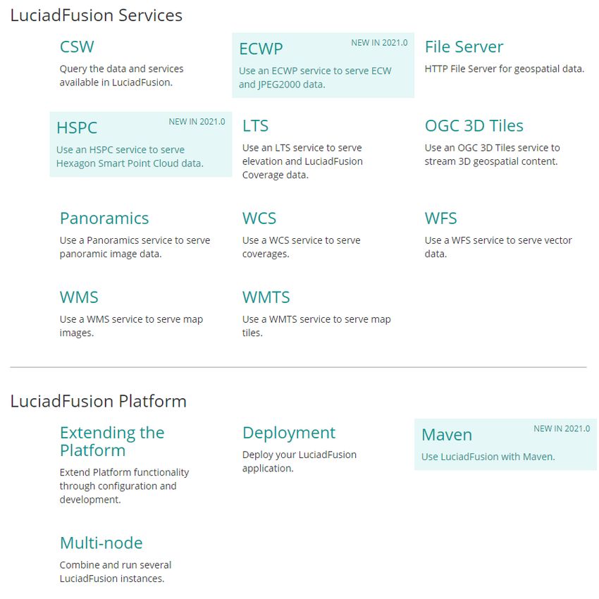
Crawl and serve ECW data as ECWP
The ECW2 imagery format provides exceptional compression while retaining the image’s full visual
quality. LuciadFusion has supported the ECW file format for many years. To serve these files, you
could use the OGC WMS or WMTS service types. While this offers the desired visual quality and the
benefit of interoperability, it does not feature the same exceptional compression and low storage
requirement.
Therefore, LuciadFusion now also supports serving ECW data via the ECW Protocol (ECWP), as
ECWP service type. You can find this capability in the Advanced Raster Connectors component, an
option within the LuciadFusion Advanced Tier and included in the Pro Tier.
Sample code to get you started
The new ECWP service type is illustrated via the integration into LuciadFusion studio. The
LuciadFusion Studio end user guide has been updated and now explains how to use this service type.
The documentation on the LuciadFusion services and service types has been restructured and
updated to reflect the changes.

    Figure 5: The new ECWP service type is available as an option when creating a new service in LuciadFusion.

Add your own custom service type
LuciadFusion ships with built-in service types for serving geospatial data and support a wide range of
clients. These service types include OGC service standards as well as Hexagon standards, like the
abovementioned newly added HSPC and ECWP service types.
To provide even more flexibility in serving geospatial data, you can now also add your own service
types to LuciadFusion. This feature allows you to use a custom protocol for serving geospatial data
managed in LuciadFusion Studio. As a result, you now have unlimited options for getting your data to
clients.
For example, you may want to combine some of the available analysis capabilities of LuciadFusion
into a custom processing chain and offer that as a processing service. An example is the sample
service that offers terrain analysis capabilities based on elevation data and returns the result as a
map layer.

2
    https://www.hexagongeospatial.com/products/power-portfolio/compression

10 June 2021                                                                                                     6
Or you may need to create a completely custom processing service, important for your application
domain, based off some of the data sets that are managed via LuciadFusion. The return type of such
a service is not limited to geospatial data or maps.
Once you have added your own service type to the platform using the new service configuration API,
it is fully supported and integrated. LuciadFusion Studio users can set up custom services based on
any data or products that are appropriate. Afterwards, the services can be monitored within the
LuciadFusion Studio Services overview.
Sample code to get you started
The implementation of the LuciadFusion TEA service sample offers an illustration of the new API for
defining and adding custom service types. Furthermore, a how-to guide has been created explaining
the addition of custom processing services: “Add a custom service type.”
Figure 6: A how-to guide explains step-by-step how to integrate your custom service type into the LuciadFusion
Platform.
10 June 2021 7Support for the Normaal Amsterdams Peil vertical datum
Amsterdam Ordnance Datum, or Normaal Amsterdams Peil (NAP)3, is a vertical datum. It was
originally created for use in the Netherlands, but it is now used in large parts of Western Europe.
LuciadFusion now supports this vertical datum, as well as the associated EPSG reference
EPSG:74154. As a LuciadFusion user, this just works for you. You can open, visualize, and use data
in this reference or referring to this vertical datum.
Figure 7: One of the landmarks used for the NAP vertical datum is the church tower in Amersfoort (building data
by 3dbag.nl).
MrSID format update
LuciadFusion’s support for imagery in the MrSID format has been updated to support generation 4
data files. In addition to the upgrade, the MrSID decoder now also includes support for multispectral
imagery. This integrates seamlessly with the existing support for multi-band and multi-spectral images
and image operators.
You can find this capability in the Advanced Raster Connectors component, which is an option within
the LuciadFusion Advanced Tier and included in LuciadFusion Pro.
Note that MrSID is a proprietary format, and the third-party software component needed to decode the
imagery no longer supports 32-bit Linux. As a result of an update to this library, LuciadFusion 2021.0
can no longer support decoding MrSID data on 32-bit Linux. Please contact us if you are deploying a
LuciadFusion-based application or service on 32-bit Linux that uses MrSID data.
3
https://en.wikipedia.org/wiki/Amsterdam_Ordnance_Datum
4
https://www.spatialreference.org/ref/epsg/7415/
10 June 2021 8Other improvements
• Support for data in the NITF format has been improved. Nested elements are better
supported in this release. You can find this capability in the Defense Standards component,
an option within the LuciadFusion Pro Tier.
• When creating a new service, LuciadFusion Studio will automatically pre-select the most likely
service type.
• The LuciadFusion OGC WMTS services now support the GetFeatureInfo operation. This
operation can be used to retrieve attribute information about features included within the
WMTS result. Note that the LuciadLightspeed WMTS client also supports this operation.
Moreover, it is integrated by default into Lucy.
• LuciadFusion now supports PostgreSQL13. You can find this capability in the Database
Connectors component, which is an option within the LuciadFusion Advanced Tier and
included within the Pro Tier.
• The documentation on LuciadFusion services and service types has been restructured. There
is now a dedicated documentation category where each LuciadFusion service is explained in
a separate section.
Figure 8: The structure of the LuciadFusion documentation has been improved. A dedicated section on
LuciadFusion services and service types has been added.
10 June 2021 9About Hexagon Hexagon is a global leader in sensor, software and autonomous solutions. We are putting data to work to boost efficiency, productivity, and quality across industrial, manufacturing, infrastructure, safety, and mobility applications. Our technologies are shaping urban and production ecosystems to become increasingly connected and autonomous — ensuring a scalable, sustainable future. Hexagon’s Geospatial division creates solutions that deliver a 5D smart digital reality with insight into what was, what is, what could be, what should be, and ultimately, what will be. Hexagon (Nasdaq Stockholm: HEXA B) has approximately 21,000 employees in 50 countries and net sales of approximately 4.4bn USD. Learn more at hexagon.com and follow us @HexagonAB. 10 June 2021 10
Copyright
© 2021 Hexagon AB and/or its subsidiaries and affiliates. All rights reserved. Hexagon has registered
trademarks in many countries throughout the world. Visit the Trademarks Page
http://www.hexagongeospatial.com/legal/trademarks for information about the countries in which the
trademarks are registered. See Product Page and Acknowledgments for more information.

Product Documentation Terms of Use
PLEASE READ THESE TERMS CAREFULLY BEFORE USING HEXAGON GEOSPATIAL’S
DOCUMENTATION ("DOCUMENT"). USE OF THIS DOCUMENT INDICATES ACCEPTANCE OF
THIS AGREEMENT WITHOUT MODIFICATION. IF YOU DO NOT AGREE TO THE TERMS
HEREOF ("TERMS"), DO NOT USE THIS DOCUMENT.

Use Of This Document
All materials in this Document are copyrighted and any unauthorized use may violate worldwide
copyright, trademark, and other laws. Subject to the terms of this Agreement, Hexagon Geospatial (a
Division of Intergraph Corporation) and Intergraph’s subsidiaries ("Intergraph") hereby authorize you
to reproduce this Document solely for your personal, non-commercial use. In consideration of this
authorization, you agree to retain all copyright and other proprietary notices contained therein. You
may not modify the Materials in any way or reproduce or publicly display, perform, or distribute or
otherwise use them for any public or commercial purpose, except as specifically authorized in a
separate agreement with Hexagon Geospatial.

The foregoing authorization specifically excludes content or material bearing a copyright notice or
attribution of rights of a third party. Except as expressly provided above, nothing contained herein
shall be construed as conferring by implication, estoppel or otherwise any license or right under any
copyright, patent or trademark of Hexagon Geospatial or Intergraph or any third party.

If you breach any of these Terms, your authorization to use this Document automatically terminates.
Upon termination, you will immediately destroy any downloaded or printed Materials in your
possession or control.

Disclaimers
ALL MATERIALS SUPPLIED HEREUNDER ARE PROVIDED "AS IS", WITHOUT WARRANTY OF
ANY KIND, EITHER EXPRESSED OR IMPLIED, INCLUDING, BUT NOT LIMITED TO, ANY
IMPLIED WARRANTIES OF MERCHANTABILITY, FITNESS FOR A PARTICULAR PURPOSE, OR
NON-INFRINGEMENT. Hexagon Geospatial does not warrant that the content of this Document will
be error-free, that defects will be corrected, or that any Hexagon Geospatial Website or the services
that make Materials available are free of viruses or other harmful components.

Hexagon Geospatial does not warrant the accuracy and completeness of this Document. Hexagon
Geospatial may make changes to this Document at any time without notice.

Limitation Of Liability
IN NO EVENT SHALL HEXAGON GEOSPATIAL BE LIABLE FOR ANY DIRECT, INDIRECT,
INCIDENTAL, SPECIAL OR CONSEQUENTIAL DAMAGES, OR DAMAGES FOR LOSS OF
PROFITS, REVENUE, DATA OR USE, INCURRED BY YOU OR ANY THIRD PARTY, WHETHER IN
AN ACTION IN CONTRACT OR TORT, ARISING FROM YOUR ACCESS TO, OR USE OF, THIS
DOCUMENT.

Indemnification
You agree to defend, indemnify, and hold harmless Hexagon Geospatial, its officers, directors,
employees, and agents from and against any and all claims, liabilities, damages, losses or expense,
including reasonable attorneys' fees and costs, arising out of or in any way connected with your
access to or use of this Document.

Use Of Software

10 June 2021                                                                                        11
Use of software described in this Document is subject to the terms of the end user license agreement
that accompanies the software, if any. You may not download or install any software that is
accompanied by or includes an end user license agreement unless you have read and accepted the
terms of such license agreement. Any such software is the copyrighted work of Hexagon Geospatial,
Intergraph or its licensors. Portions of the user interface copyright 2012- Telerik AD.
Links To Third Party Websites
This Document may provide links to third party websites for your convenience and information. Third
party websites will be governed by their own terms and conditions. Hexagon Geospatial does not
endorse companies or products to which it links.
Third party websites are owned and operated by independent parties over which Hexagon Geospatial
has no control. Hexagon Geospatial shall not have any liability resulting from your use of the third
party website. Any link you make to or from the third party website will be at your own risk and any
information you share with the third party website will be subject to the terms of the third party
website, including those relating to confidentiality, data privacy, and security.
Trademarks
The trademarks, logos and service marks ("Marks") displayed in this Document are the property of
Hexagon Geospatial, Intergraph or other third parties. Users are not permitted to use Marks without
the prior written consent of Hexagon Geospatial, Intergraph or the third party that owns the Mark.
"Intergraph" is a registered trademark of Intergraph Corporation in the United States and in other
countries. Other brands and product names are trademarks of their respective owners.
Find additional trademark information http://www.hexagongeospatial.com/legal/trademarks.
Procedure For Making Claims Of Copyright Infringement
Notifications of claimed copyright infringement should be sent to Hexagon Geospatial by mail at the
following address: Intergraph Corporation, Attn: Intergraph Legal Department, P.O. Box 240000,
Huntsville, Alabama 35824.
US Government Restricted Right
Materials are provided with "RESTRICTED RIGHTS." Use, duplication, or disclosure of Materials by
the U.S. Government is subject to restrictions as set forth in FAR 52.227-14 and DFARS 252.227-
7013 et seq. or successor provisions thereto. Use of Materials by the Government constitutes
acknowledgment of Hexagon Geospatial or Intergraph’s proprietary rights therein.
International Use
You may not use or export Materials in violation of U.S. export laws and regulations. Hexagon
Geospatial makes no representation that Materials are appropriate or available for use in every
country, and access to them from territories where their content is illegal is prohibited.
Hexagon Geospatial provides access to Hexagon Geospatial international data and, therefore, may
contain references or cross references to Hexagon Geospatial products, programs and services that
are not announced in your country. These references do not imply that Hexagon Geospatial intends to
announce such products, programs or services in your country.
The Materials are subject to U.S. export control and economic sanctions laws and regulations and
you agree to comply strictly with all such laws and regulations. In addition, you represent and warrant
that you are not a national of, or otherwise located within, a country subject to U.S. economic
sanctions (including without limitation Iran, Syria, Sudan, Cuba, and North Korea) and that you are not
otherwise prohibited from receiving or accessing the Materials under U.S. export control and
economic sanctions laws and regulations. Hexagon Geospatial makes no representation that the
Materials are appropriate or available for use in every country, and access to them from territories
where their content is illegal is prohibited. All rights to use the Materials are granted on condition that
such rights are forfeited if you fail to comply with the terms of this agreement.
10 June 2021 12Revisions Hexagon Geospatial reserves the right to revise these Terms at any time. You are responsible for regularly reviewing these Terms. Your continued use of this Document after the effective date of such changes constitutes your acceptance of and agreement to such changes. Applicable Law This Document is created and controlled by Hexagon Geospatial in the State of Alabama. As such, the laws of the State of Alabama will govern these Terms, without giving effect to any principles of conflicts of law. You hereby irrevocably and unconditionally consent to submit to the exclusive jurisdiction of the United States District Court for the Northern District of Alabama, Northeastern Division, or the Circuit Court for Madison County, Alabama for any litigation arising out of or relating to use of this Document (and agree not to commence any litigation relating thereto except in such courts), waive any objection to the laying of venue of any such litigation in such Courts and agree not to plead or claim in any such Courts that such litigation brought therein has been brought in an inconvenient forum. Some jurisdictions do not allow the exclusions or limitations set forth in these Terms. Such exclusions or limitations shall apply in all jurisdictions to the maximum extent allowed by applicable law. Questions Contact us https://www.hexagongeospatial.com/about-us/our-company/contact-us with any questions regarding these Terms. 10 June 2021 13
You can also read